
Extraction of Aquaculture Pond Region in Coastal Waters of Southeast China Based on Spectral Features and Spatial Convolution

Abstract
1. Introduction
2. Study Area and Data Sources
2.1. Study Area
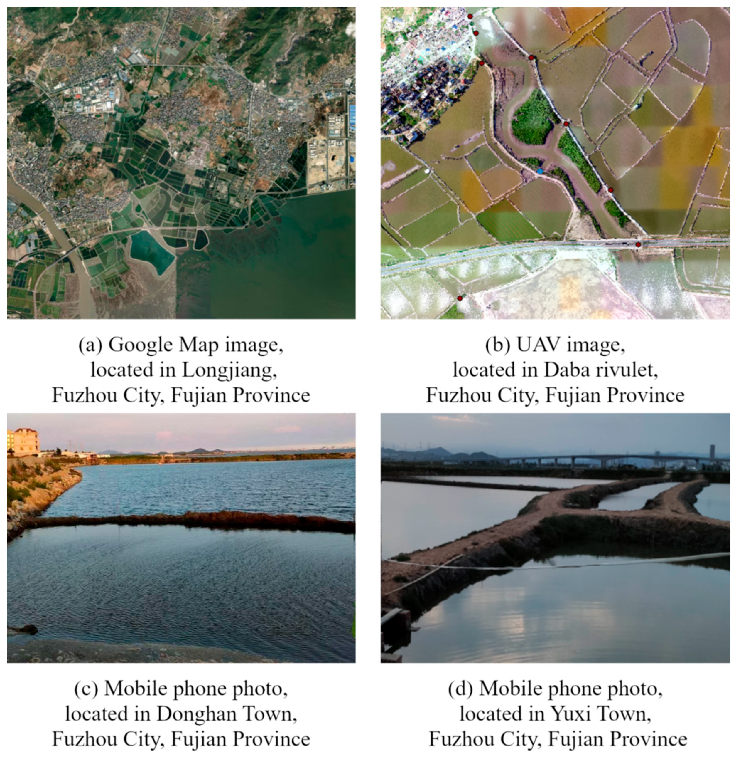
2.2. Data Sources
3. Research Methods
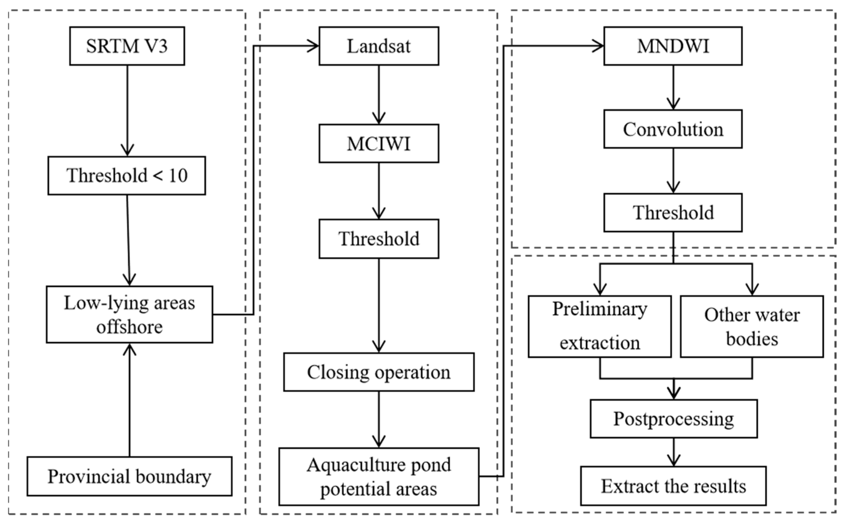
3.1. Delineation of Aquaculture Coverage Area Supported by DEM
3.2. Elimination of Non-Water Information Based on Morphological and Spectral Characteristics
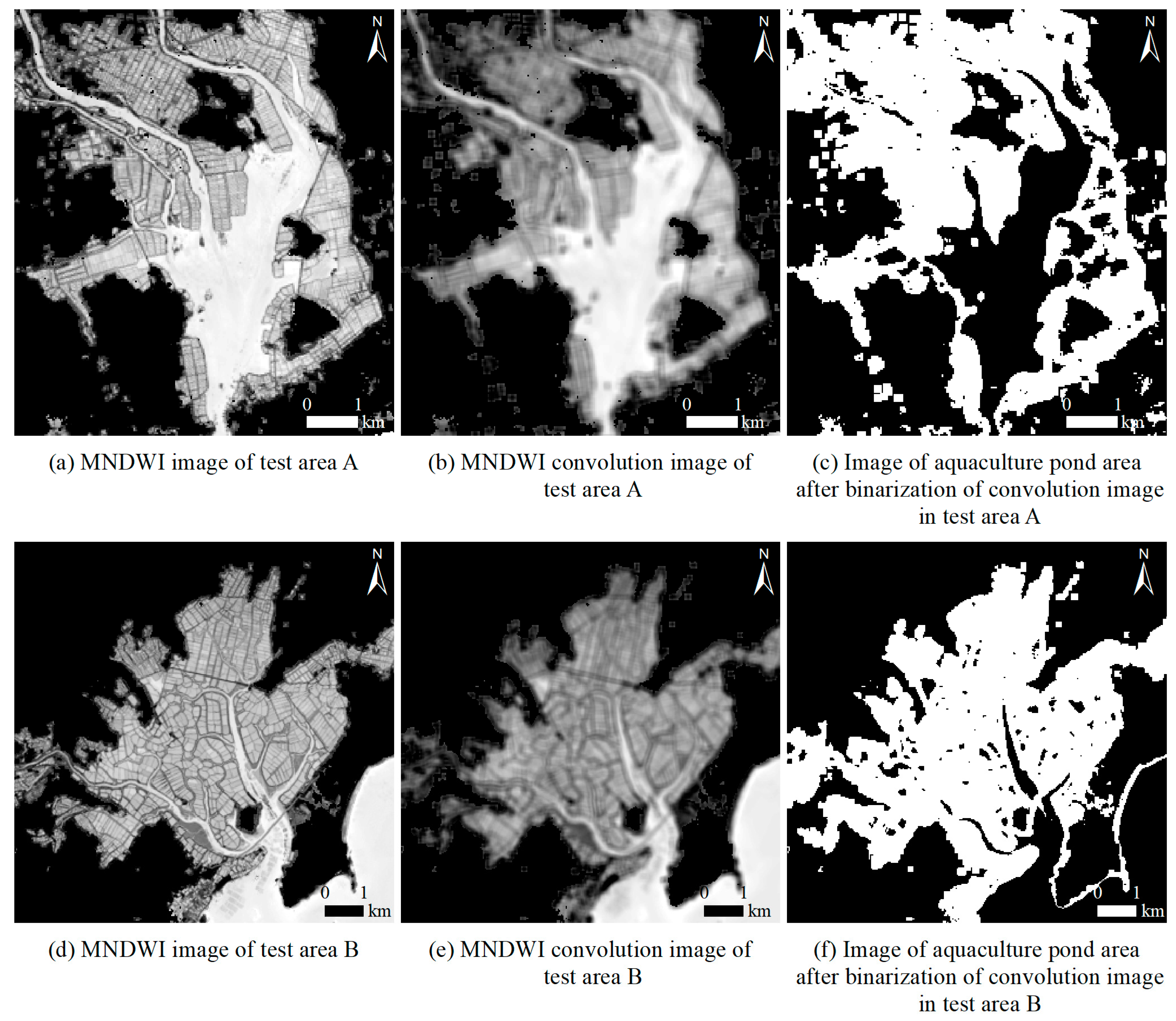
3.3. Information Elimination of Non-Aquaculture Water Body Based on Spatial Convolution
3.4. Postprocessing
4. Results and Analysis
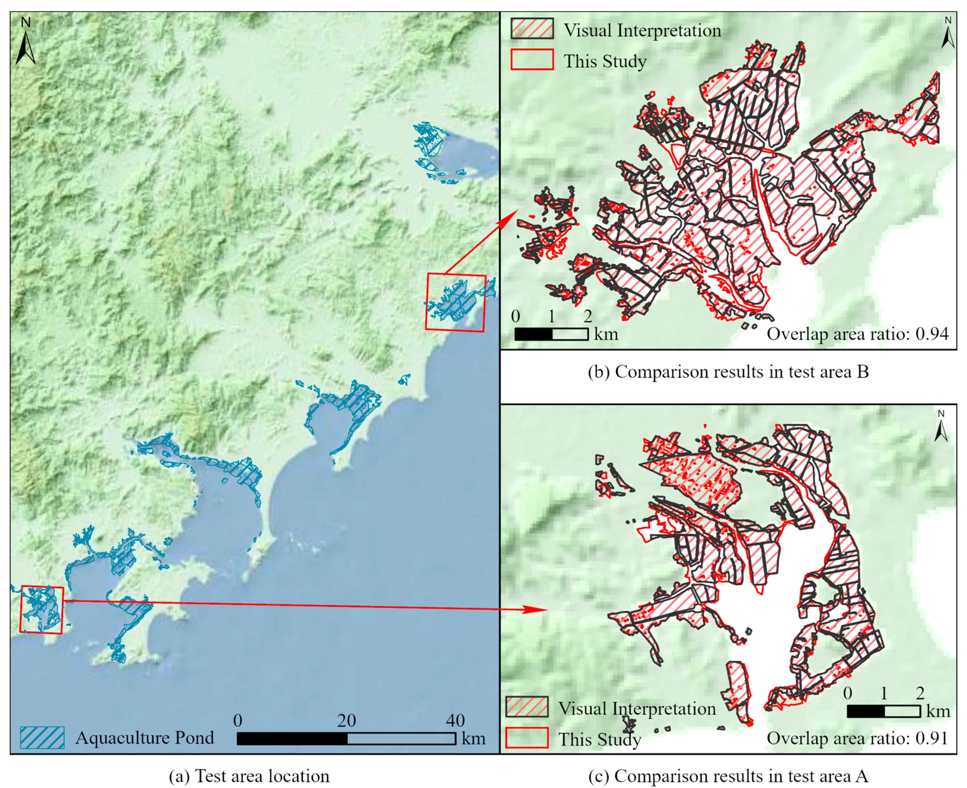
4.1. Extraction Results and Accuracy Evaluation of Aquaculture Area
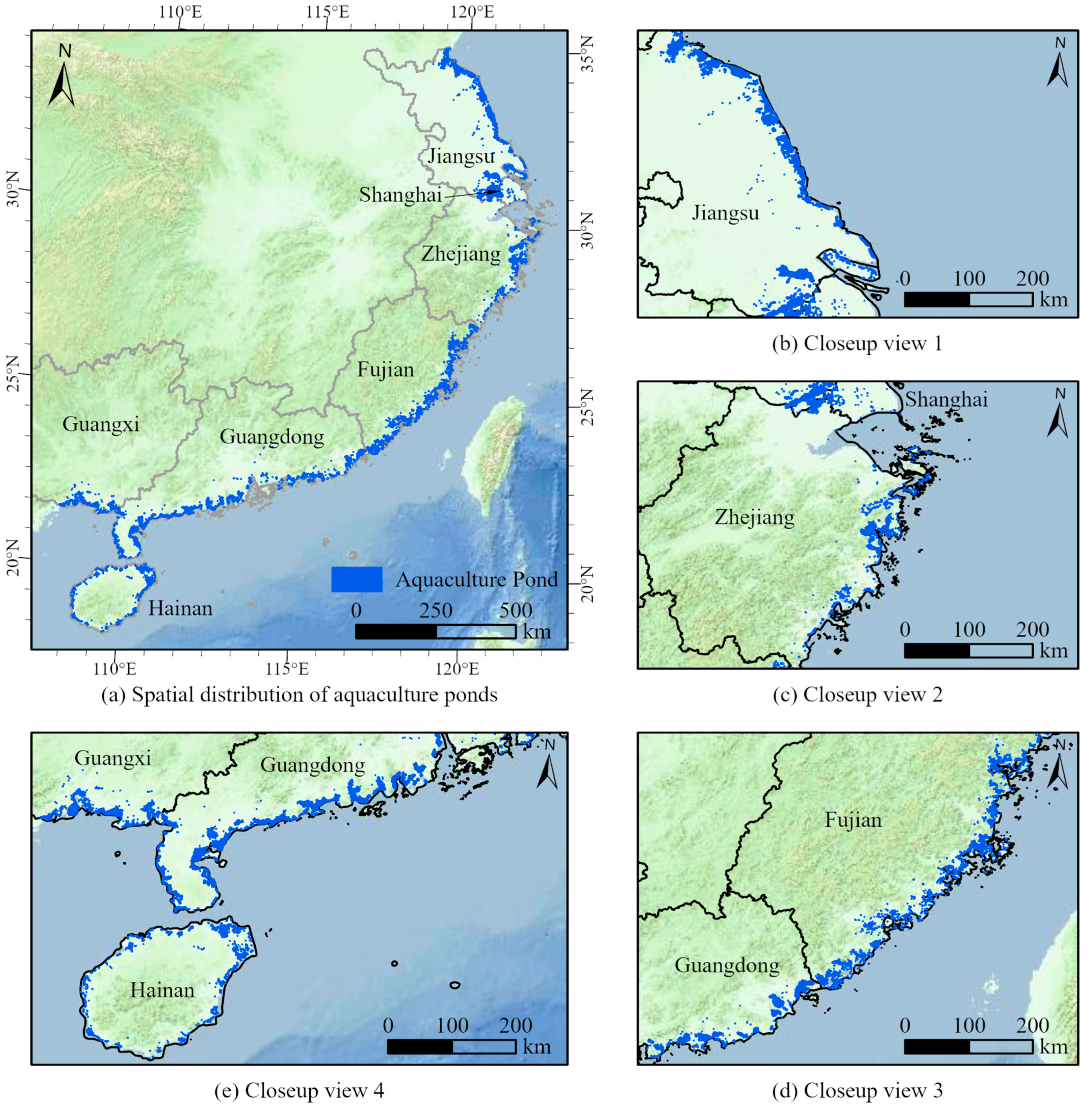
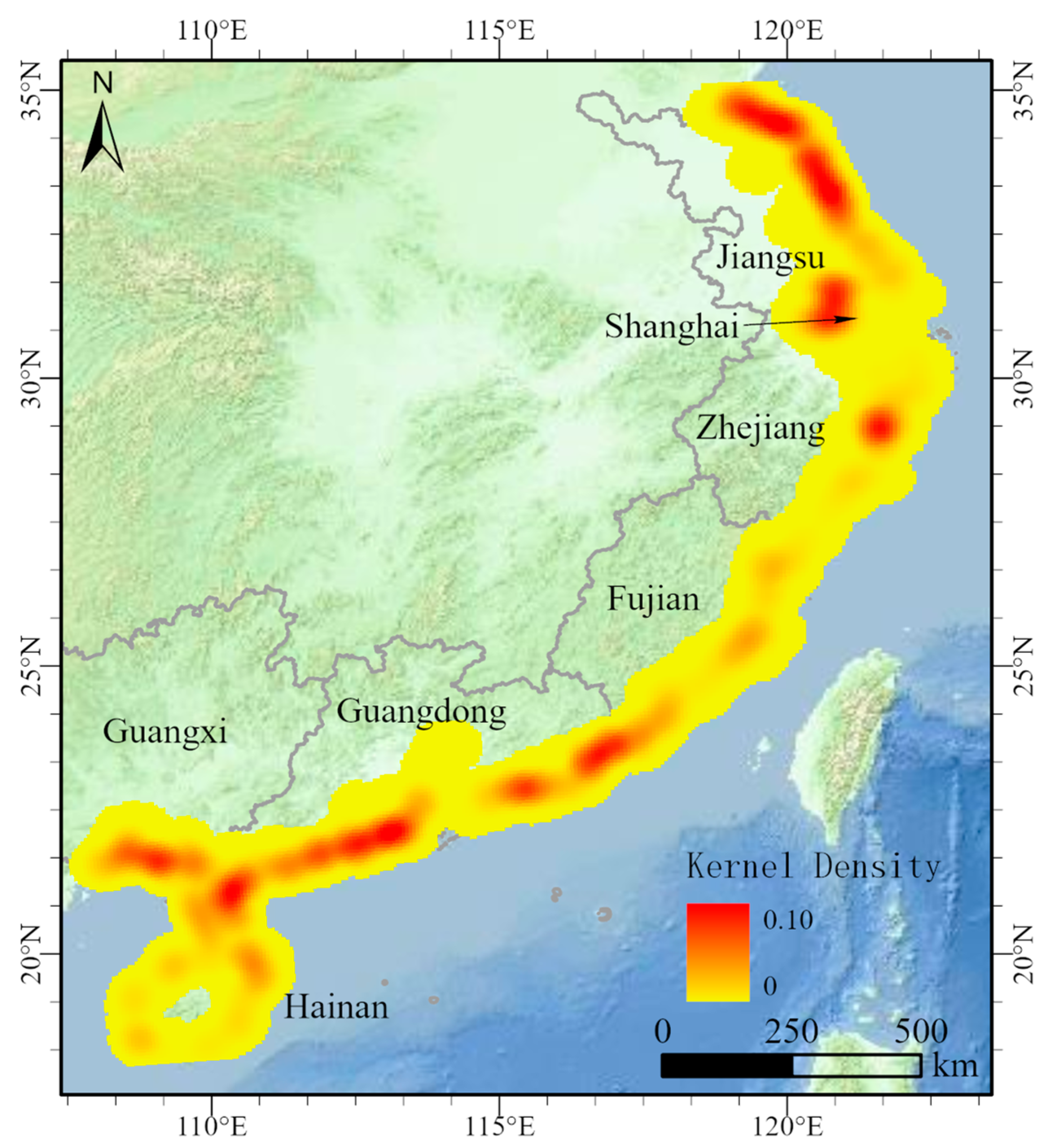
4.2. Spatial Distribution and Density Analysis of Aquaculture Area
5. Discussion
- Replace individual extraction with whole recognition. Under the 30 m spatial resolution of Landsat series satellites, the relatively fragmented land patches along the coast, small-scale aquaculture ponds, and dikes constituted a large number of mixed pixels. Thus, it was unrealistic to extract each pit and pond. The extraction of the aquaculture pond area as a whole not only improved the identification accuracy, but also conformed to the attributes of aquaculture land use type. This method met the management needs of the fishery survey on spatial distribution and change statistics of aquaculture ponds at a specific scale.
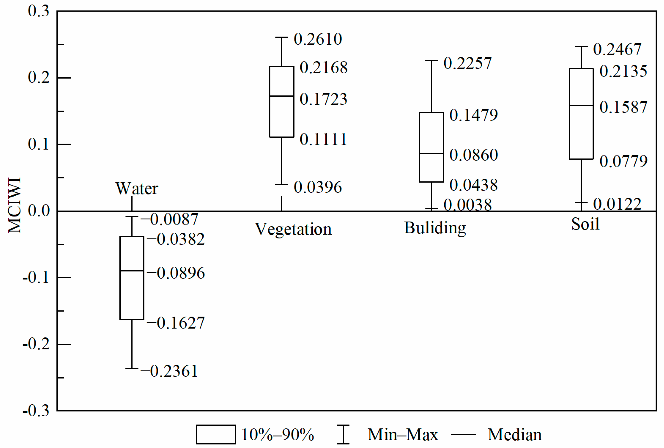
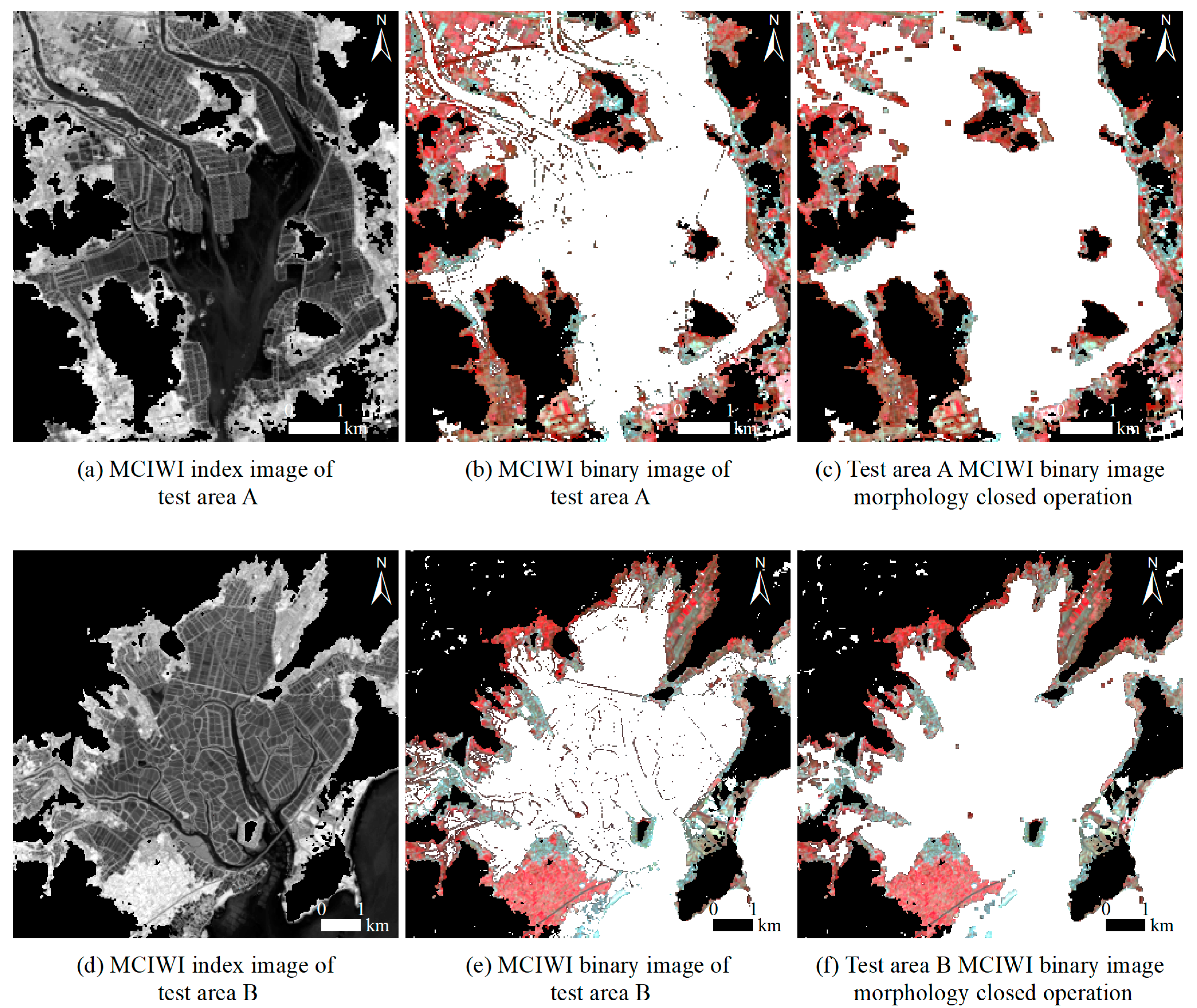
- Combine double water spectral indices. In essence, an aquaculture pond is a special water body divided by complex roads and dikes. Therefore, a water spectral index can theoretically realize the identification and extraction of an aquaculture pond, but it was difficult for the traditional single spectral index to achieve large-scale effective separation. MCIWI offered the advantage of distinguishing the land–water boundary and highlighting large areas of water (Figure 5), whereas MNDWI offered the advantage of distinguishing fine water and highlighting the grid characteristics of aquaculture ponds (Figure 7). The combination of indices made up for the shortcoming of a single spectral index, and effectively realized the separation of aquaculture and non-aquaculture water bodies.
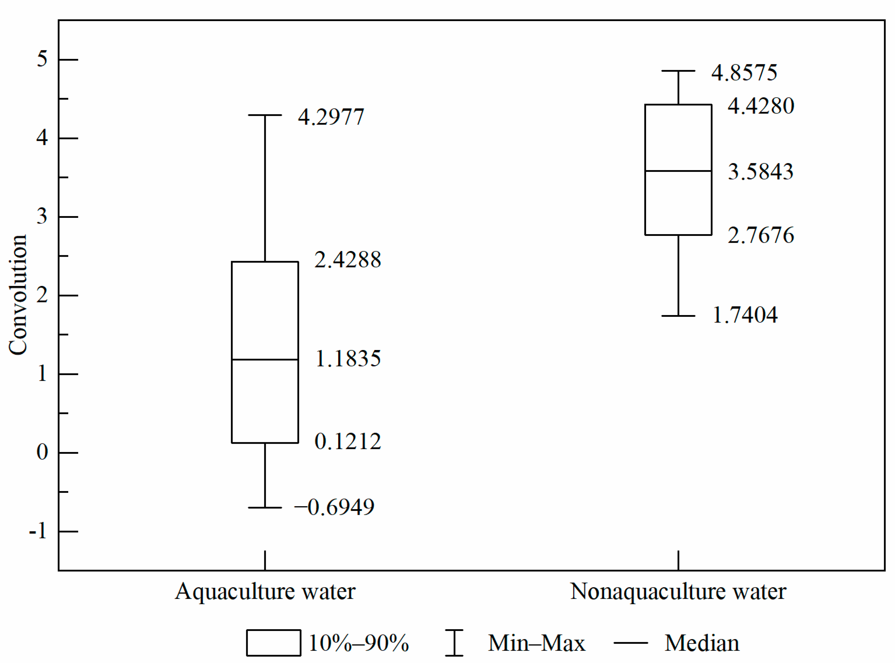
- Conduct spatial convolution filtering. Spectral characteristics and threshold processing alone cannot distinguish between aquaculture and non-aquaculture water bodies. Based on the network characteristics of aquaculture ponds, which are segmented by roads and dikes, we tested a texture index and a spatial index, and found that after low-pass filtering convolution of the MNDWI image, the differences in characteristics between the two types of water bodies can be significantly stretched (Figure 8 and Figure 9). Therefore, this provided good extraction for the aquaculture pond.
- Under the spatial resolution of the Landsat image and the perspective of provincial scale, the aquaculture pond identified as a whole by region inevitably contains sub-pixel-scale channels and dikes in the region. The width of such ground objects is between 3 m and 10 m. This area is included in the extraction results of the aquaculture pond, which is one of the sources of error.
- Scattered or small scattered aquaculture ponds interspersed between tidal flats and seawater forms mixed pixels with surrounding features, resulting in misclassification or missing classifications, which is the second source of error.
- Objective reasons, such as fishermen’s irregular pond-clearing behavior and the influence of cloud cover in the optimal collection phase, can lead to the partial probability of a dry pond, and such information is misclassified as land, which is the third source of error.
6. Conclusions
Author Contributions
Funding
Institutional Review Board Statement
Informed Consent Statement
Data Availability Statement
Acknowledgments
Conflicts of Interest
References
- FAO. FAO Yearbook. In Fishery and Aquaculture Statistics 2018; FAO: Roma, Italy, 2020. [Google Scholar]
- Several Opinions of the State Council on Promoting the Sustainable and Healthy Development of Marine Fishery. Available online: http://www.gov.cn/zwgk/2013-06/25/content_2433577.htm (accessed on 25 June 2013).
- Fishery Highlight Serialization in the 13th Five-Year Plan|Accelerating the Transformation and Upgrading in Fishery and Achieving Tangible Results of High Quality Developments. Available online: http://www.yyj.moa.gov.cn/gzdt/202012/t20201208_6357773.htm (accessed on 8 December 2020).
- Fu, Y. Classification of Coastal Mariculture Area and Its Spatial Characteristics in China. Doctoral Thesis, Zhejiang University, Hangzhou, China, 2020. [Google Scholar]
- Wu, L.; Yang, S. Discussion on structure optimization and management of aquaculture ecosystem. Mar. Sci. 2002, 26, 15–17. [Google Scholar] [CrossRef]
- Li, S. Water pollution in inland aquaculture and its control measures. J. Fish. Sci. 2005, 24, 34–35. [Google Scholar] [CrossRef]
- Chen, L.; Ren, C.; Zhang, B.; Li, L.; Wang, Z.; Song, K. Spatiotemporal Dynamics of Coastal Wetlands and Reclamation in the Yangtze Estuary during Past 50 Years (1960s–2015). Chin. Geogr. Sci. 2018, 28, 386–399. [Google Scholar] [CrossRef]
- Zhou, M.; Wu, M.; Zhang, G.; Zhao, L.; Hou, X.; Yang, Y. Analysis of Coastal Zone Data of Northern Yantai Collected by Remote Sensing from 1990 to 2018. Appl. Sci. 2019, 9, 4466. [Google Scholar] [CrossRef]
- Xu, M.; Cui, B.; Lan, S.; Li, D.; Wang, Y.; Jiang, B. Exploring Dynamic Change of the Tidal Flat Aquaculture Area in the Shandong Peninsula (China) using Multitemporal Landsat Imagery (1990–2015). J. Coast. Res. 2020, 99, 197. [Google Scholar] [CrossRef]
- Jayanthi, M.; Nila Rekha, P.; Kavitha, N.; Ravichandran, P. Assessment of impact of aquaculture on Kolleru Lake (India) using remote sensing and Geographical Information System. Aquac. Res. 2006, 37, 1617–1626. [Google Scholar] [CrossRef]
- Sun, N.; Zhu, W.; Cheng, Q. GF-1 and Landsat observed a 40-year wetland spatiotemporal variation and its coupled environmental factors in Yangtze River estuary. Estuar. Coast. Shelf Sci. 2018, 207, 30–39. [Google Scholar] [CrossRef]
- Alonso-Pérez, F.; Ruiz-Luna, A.; Turner, J.; Berlanga-Robles, C.A.; Mitchelson-Jacob, G. Land cover changes and impact of shrimp aquaculture on the landscape in the Ceuta coastal lagoon system, Sinaloa, Mexico. Ocean. Coast. Manag. 2003, 46, 583–600. [Google Scholar] [CrossRef]
- Gusmawati, N.; Soulard, B.; Selmaoui-Folcher, N.; Proisy, C.; Mustafa, A.; Le Gendre, R.; Laugier, T.; Lemonnier, H. Surveying shrimp aquaculture pond activity using multitemporal VHSR satellite images—Case study from the Perancak estuary, Bali, Indonesia. Mar. Pollut. Bull. 2018, 131, 49–60. [Google Scholar] [CrossRef]
- Li, F.; Liu, K.; Tang, H.; Liu, L.; Liu, H. Analyzing Trends of Dike-Ponds between 1978 and 2016 Using Multi-Source Remote Sensing Images in Shunde District of South China. Sustainability 2018, 10, 3504. [Google Scholar] [CrossRef]
- Cui, B.; Zhong, Y.; Fei, D.; Zhang, Y.; Liu, R.; Chu, J.; Zha, J. Floating raft aquaculture area automatic extraction based on fully convolutional network. J. Coast. Res. 2019, 90, 86–94. [Google Scholar] [CrossRef]
- Cui, B.; Fei, D.; Shao, G.; Lu, Y.; Chu, J. Extracting Raft Aquaculture Areas from Remote Sensing Images via an Improved U-Net with a PSE Structure. Remote Sens. 2019, 11, 2053. [Google Scholar] [CrossRef]
- Liu, Y.; Yang, X.; Wang, Z.; Lu, C.; Li, Z.; Yang, F. Aquaculture area extraction and vulnerability assessment in Sanduao based on richer convolutional features network model. J. Oceanol. Limnol. 2019, 37, 1941–1954. [Google Scholar] [CrossRef]
- Nguyen-Van-Anh, V.; Hoang-Phi, P.; Nguyen-Kim, T.; Lam-Dao, N.; Vu, T.T. The influence of satellite image spatial resolution on mapping land use/land cover: A case study of Ho Chi Minh City, Vietnam. In IOP Conference Series: Earth and Environmental Science; IOP Publishing: Bristol, UK, 2021; Volume 652, p. 12002. [Google Scholar] [CrossRef]
- Cheng, B.; Liu, Y.; Liu, X.; Wang, G.; Ma, X. Research on Extraction Method of Coastal Aquaculture Areas on High Resolution Remote Sensing Image based on Multi-features Fusio. Remote Sens. Technol. Appl. 2018, 33, 296–304. [Google Scholar] [CrossRef]
- Huang, S.; Song, K.; Luo, J.; Zhao, J.; Ma, R. A remote sensing extraction algorithm of enclosure culture area in shallow lakes based on gradient transform. J. Lake Sci. 2017, 29, 490–497. [Google Scholar] [CrossRef][Green Version]
- Wang, J.; Sui, L.; Yang, X.; Wang, Z.; Liu, Y.; Kang, J.; Lu, C.; Yang, F.; Liu, B. Extracting Coastal Raft Aquaculture Data from Landsat 8 OLI Imagery. Sensors 2019, 19, 1221. [Google Scholar] [CrossRef]
- Zhang, X.; Ma, S.; Su, C.; Shang, Y.; Wang, T.; Yin, J. Coastal oyster aquaculture area extraction and nutrient loading estimation using a GF-2 satellite image. IEEE J. Sel. Top. Appl. Earth Obs. Remote Sens. 2020, 13, 4934–4946. [Google Scholar] [CrossRef]
- Sridhar, P.N.; Surendran, A.; Ramana, I.V. Auto-extraction technique-based digital classification of saltpans and aquaculture plots using satellite data. Int. J. Remote Sens. 2008, 29, 313–323. [Google Scholar] [CrossRef]
- Fu, Y.; Deng, J.; Ye, Z.; Gan, M.; Wang, K.; Wu, J.; Yang, W.; Xiao, G. Coastal aquaculture mapping from very high spatial resolution imagery by combining Object-Based neighbor features. Sustainability 2019, 11, 637. [Google Scholar] [CrossRef]
- Virdis, S.G.P. An object-based image analysis approach for aquaculture ponds precise mapping and monitoring: A case study of Tam Giang-Cau Hai Lagoon, Vietnam. Environ. Monit. Assess. 2014, 186, 117–133. [Google Scholar] [CrossRef]
- Disperati, L.; Virdis, S.G.P. Assessment of land-use and land-cover changes from 1965 to 2014 in Tam Giang-Cau Hai Lagoon, central Vietnam. Appl. Geogr. 2015, 58, 48–64. [Google Scholar] [CrossRef]
- Kang, J.; Sui, L.; Yang, X.; Liu, Y.; Wang, Z.; Wang, J.; Yang, F.; Liu, B.; Ma, Y. Sea Surface-Visible Aquaculture Spatial-Temporal Distribution Remote Sensing: A Case Study in Liaoning Province, China from 2000 to 2018. Sustainability 2019, 11, 7186. [Google Scholar] [CrossRef]
- Sui, B.; Jiang, T.; Zhang, Z.; Pan, X.; Liu, C. A modeling method for automatic extraction of offshore aquaculture zones based on semantic segmentation. ISPRS Int. J. Geo-Inf. 2020, 9, 145. [Google Scholar] [CrossRef]
- Liang, C.; Cheng, B.; Xiao, B.; He, C.; Liu, X.; Jia, N.; Chen, J. Semi-/Weakly-Supervised semantic segmentation method and its application for coastal aquaculture areas based on Multi-Source remote sensing images—Taking the fujian coastal area (Mainly sanduo) as an example. Remote Sens. 2021, 13, 1083. [Google Scholar] [CrossRef]
- Ren, C.; Wang, Z.; Zhang, B.; Li, L.; Chen, L.; Song, K.; Jia, M. Remote Monitoring of Expansion of Aquaculture Ponds Along Coastal Region of the Yellow River Delta from 1983 to 2015. Chin. Geogr. Sci. 2018, 28, 430–442. [Google Scholar] [CrossRef]
- Zhang, T.; Yang, X.; Hu, S.; Su, F. Extraction of coastline in aquaculture coast from multispectral remote sensing images: Object-Based region growing integrating edge detection. Remote Sens. 2013, 5, 4470–4487. [Google Scholar] [CrossRef]
- Gorelick, N.; Hancher, M.; Dixon, M.; Ilyushchenko, S.; Thau, D.; Moore, R. Google Earth Engine: Planetary-scale geospatial analysis for everyone. Remote Sens. Environ. 2017, 202, 18–27. [Google Scholar] [CrossRef]
- Xia, Z.; Guo, X.; Chen, R. Automatic extraction of aquaculture ponds based on Google Earth Engine. Ocean. Coast. Manag. 2020, 198, 105348. [Google Scholar] [CrossRef]
- Meilianda, E.; Pradhan, B.; Syamsidik; Comfort, L.K.; Alfian, D.; Juanda, R.; Syahreza, S.; Munadi, K. Assessment of post-tsunami disaster land use/land cover change and potential impact of future sea-level rise to low-lying coastal areas: A case study of Banda Aceh coast of Indonesia. Int. J. Disaster Risk Reduct. 2019, 41, 101292. [Google Scholar] [CrossRef]
- Chen, D.; Wang, Y.; Shen, Z.; Liao, J.; Chen, J.; Sun, S. Long Time-Series mapping and change detection of coastal zone land use based on google earth engine and Multi-Source data fusion. Remote Sens. 2022, 14, 1. [Google Scholar] [CrossRef]
- Tew, Y.L.; Tan, M.L.; Samat, N.; Chan, N.W.; Mahamud, M.A.; Sabjan, M.A.; Lee, L.K.; See, K.F.; Wee, S.T. Comparison of three water indices for tropical aquaculture ponds extraction using google earth engine. Sains Malays. 2022, 51, 369–378. [Google Scholar] [CrossRef]
- Yu, Z.; Di, L.; Rahman, M.S.; Tang, J. Fishpond mapping by spectral and Spatial-Based filtering on google earth engine: A case study in singra upazila of bangladesh. Remote Sens. 2020, 12, 2692. [Google Scholar] [CrossRef]
- Xu, Y.; Hu, Z.; Zhang, Y.; Wang, J.; Yin, Y.; Wu, G. Mapping aquaculture areas with Multi-Source spectral and texture features: A case study in the pearl river basin (Guangdong), China. Remote Sens. 2021, 13, 4320. [Google Scholar] [CrossRef]
- Yang, P.; Tan, L.; Huang, J.; He, Q.; Tong, C. Diurnal variations of CH4 and N2O fluxes from the drained aquaculture pond in the minjiang river estuary during early winter. Environ. Sci. 2018, 39, 300–309. [Google Scholar] [CrossRef]
- Ren, C.; Wang, Z.; Zhang, Y.; Zhang, B.; Chen, L.; Xi, Y.; Xiao, X.; Doughty, R.B.; Liu, M.; Jia, M.; et al. Rapid expansion of coastal aquaculture ponds in China from Landsat observations during 1984–2016. Int. J. Appl. Earth Obs. Geoinf. 2019, 82, 101902. [Google Scholar] [CrossRef]
- Duan, Y.; Li, X.; Zhang, L.; Liu, W.; Liu, S.; Chen, D.; Ji, H. Detecting spatiotemporal changes of large-scale aquaculture ponds regions over 1988–2018 in Jiangsu Province, China using Google Earth Engine. Ocean. Coast. Manag. 2020, 188, 105144. [Google Scholar] [CrossRef]
- Duan, Y.; Li, X.; Zhang, L.; Chen, D.; Liu, S.; Ji, H. Mapping national-scale aquaculture ponds based on the Google Earth Engine in the Chinese coastal zone. Aquaculture 2020, 520, 734666. [Google Scholar] [CrossRef]
- Yang, B.; Chen, F.; Luo, Z. Extraction of complex water information based on MODIS Improved combined water Index (MCIWI). J. Southwest Univ. 2011, 33, 112–119. [Google Scholar] [CrossRef]
- Otsu, N. A Threshold Selection Method from Gray-Level Histograms. IEEE Trans. Syst. Man Cybern. 1979, 9, 62–66. [Google Scholar] [CrossRef]
- Zhang, G.; Wu, M.; Wei, J.; He, Y.; Niu, L.; Li, H.; Xu, G. Adaptive threshold model in google earth engine: A case study of ulva prolifera extraction in the south yellow sea, China. Remote Sens. 2021, 13, 3240. [Google Scholar] [CrossRef]
- Donchyts, G.; Schellekens, J.; Winsemius, H.; Eisemann, E.; van de Giesen, N. A 30 m Resolution Surface Water Mask Including Estimation of Positional and Thematic Differences Using Landsat 8, SRTM and OpenStreetMap: A Case Study in the Murray-Darling Basin, Australia. Remote Sens. 2016, 8, 386. [Google Scholar] [CrossRef]
- Xu, H. Modification of normalised difference water index (NDWI) to enhance open water features in remotely sensed imagery. Int. J. Remote Sens. 2006, 27, 3025–3033. [Google Scholar] [CrossRef]


| Attribute Data | Validation Data | User’s Accuracy | |
|---|---|---|---|
| Aquaculture Pond Areas | Nonaquaculture Pond Areas | ||
| Aquaculture pond areas | 205 | 27 | 0.88 |
| Non-aquaculture pond areas | 8 | 260 | 0.97 |
| Producer’s accuracy | 0.96 | 0.91 | |
| Total accuracy = 93% | Kappa = 0.86 | ||
| Region * | Extraction Area/km2 | Percentage/% |
|---|---|---|
| Jiangsu | 1858.96 | 29.28 |
| Shanghai | 62.23 | 0.98 |
| Zhejiang | 490.59 | 7.73 |
| Fujian | 552.59 | 8.70 |
| Guangdong | 2458.60 | 38.73 |
| Guangxi | 522.87 | 8.24 |
| Hainan | 402.67 | 6.34 |
| Total | 6348.51 | 100 |
Publisher’s Note: MDPI stays neutral with regard to jurisdictional claims in published maps and institutional affiliations. |
© 2022 by the authors. Licensee MDPI, Basel, Switzerland. This article is an open access article distributed under the terms and conditions of the Creative Commons Attribution (CC BY) license (https://creativecommons.org/licenses/by/4.0/).
Share and Cite
Wang, L.; Li, Y.; Zhang, D.; Liu, Z. Extraction of Aquaculture Pond Region in Coastal Waters of Southeast China Based on Spectral Features and Spatial Convolution. Water 2022, 14, 2089. https://doi.org/10.3390/w14132089
Wang L, Li Y, Zhang D, Liu Z. Extraction of Aquaculture Pond Region in Coastal Waters of Southeast China Based on Spectral Features and Spatial Convolution. Water. 2022; 14(13):2089. https://doi.org/10.3390/w14132089
Chicago/Turabian StyleWang, Lin, Yefan Li, Dongzhu Zhang, and Zhicai Liu. 2022. "Extraction of Aquaculture Pond Region in Coastal Waters of Southeast China Based on Spectral Features and Spatial Convolution" Water 14, no. 13: 2089. https://doi.org/10.3390/w14132089
APA StyleWang, L., Li, Y., Zhang, D., & Liu, Z. (2022). Extraction of Aquaculture Pond Region in Coastal Waters of Southeast China Based on Spectral Features and Spatial Convolution. Water, 14(13), 2089. https://doi.org/10.3390/w14132089