
Impacts of Gauge Data Bias on the Performance Evaluation of Satellite-Based Precipitation Products in the Arid Region of Northwestern China


Abstract
:1. Introduction
2. Materials and Methods
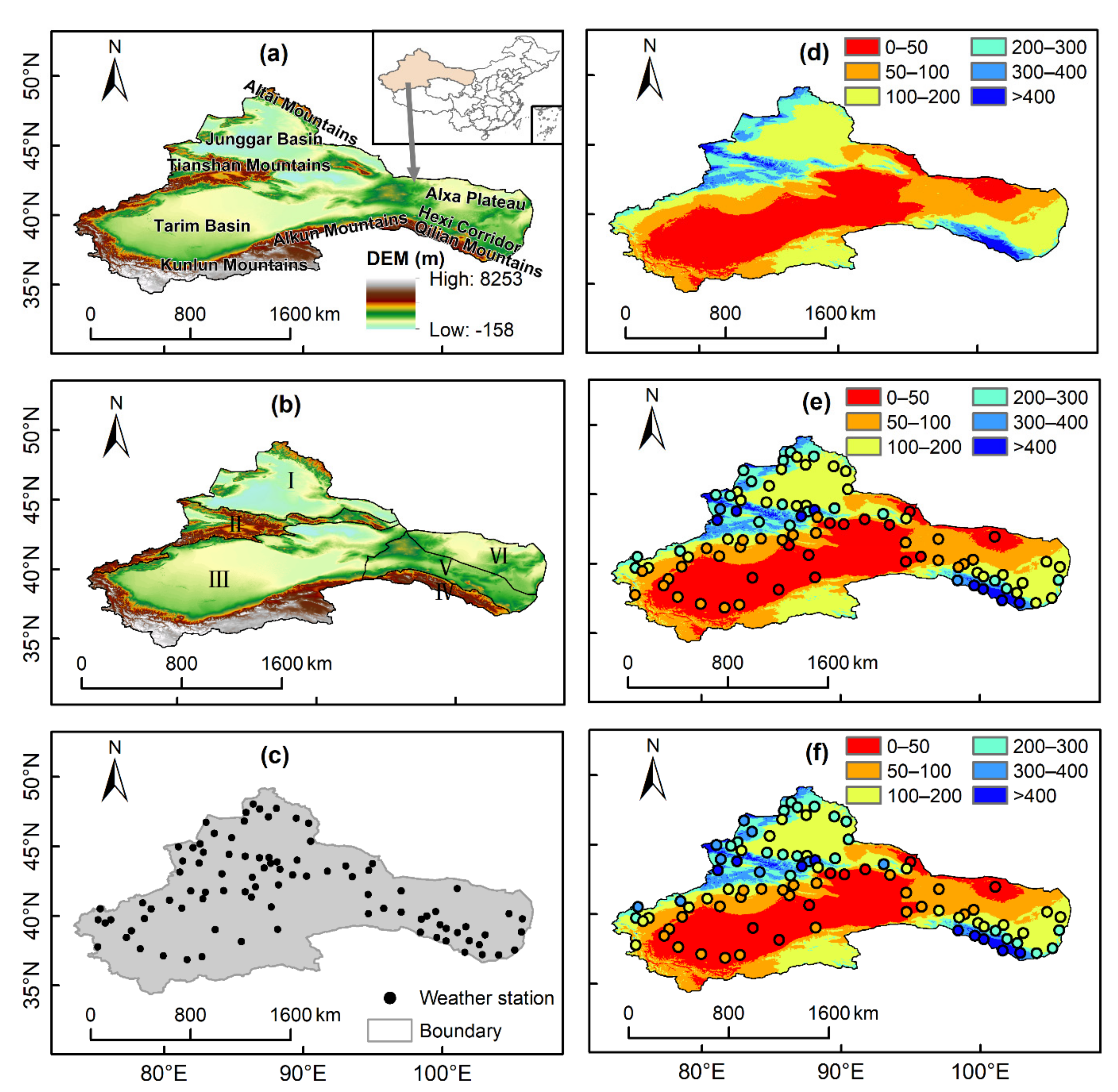
2.1. Study Area
2.2. Datasets
2.2.1. Ground Observation Data
2.2.2. Satellite Precipitation Products
2.3. Methods
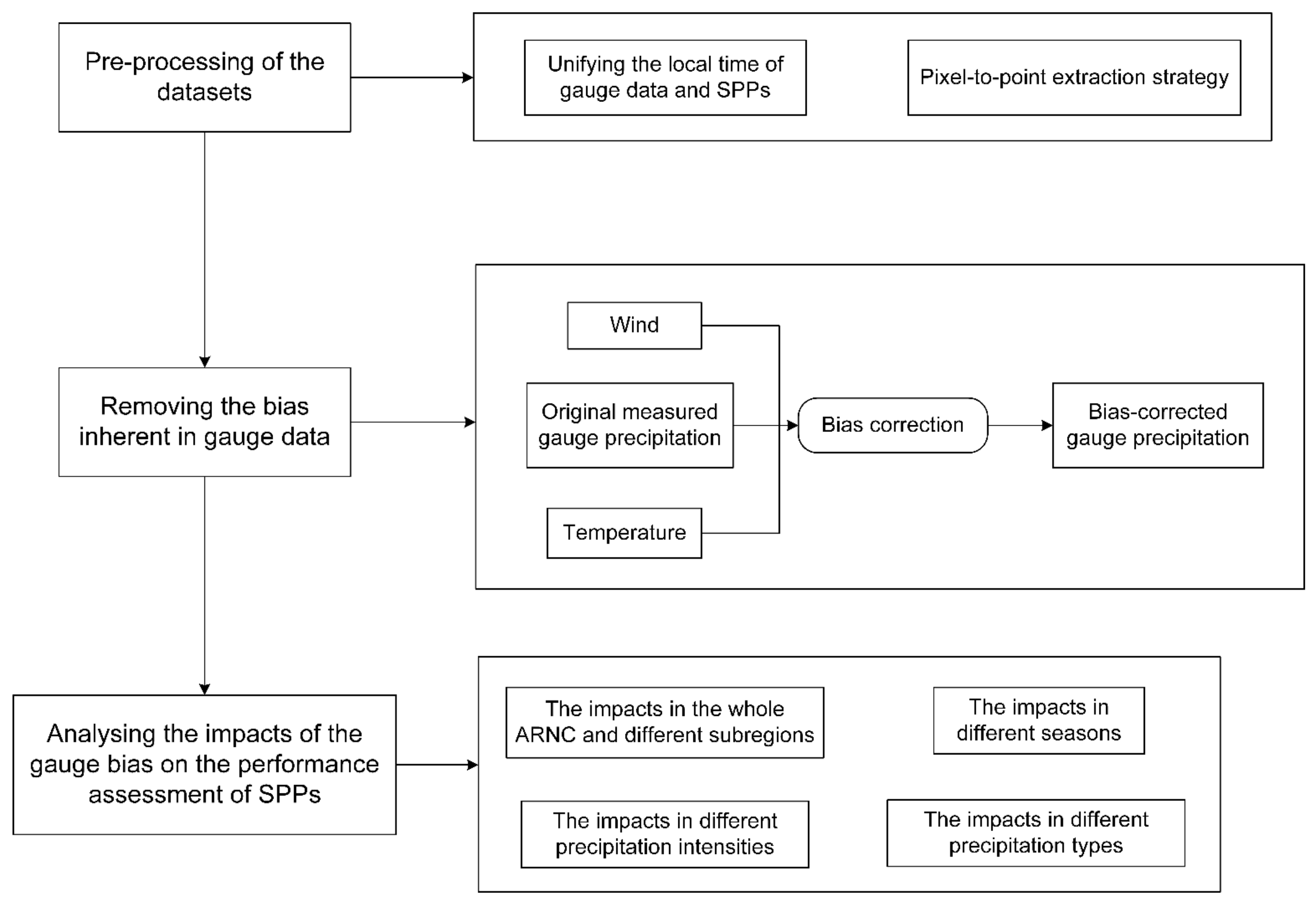
2.3.1. Preprocessing of the Datasets
2.3.2. Evaluation Metrics
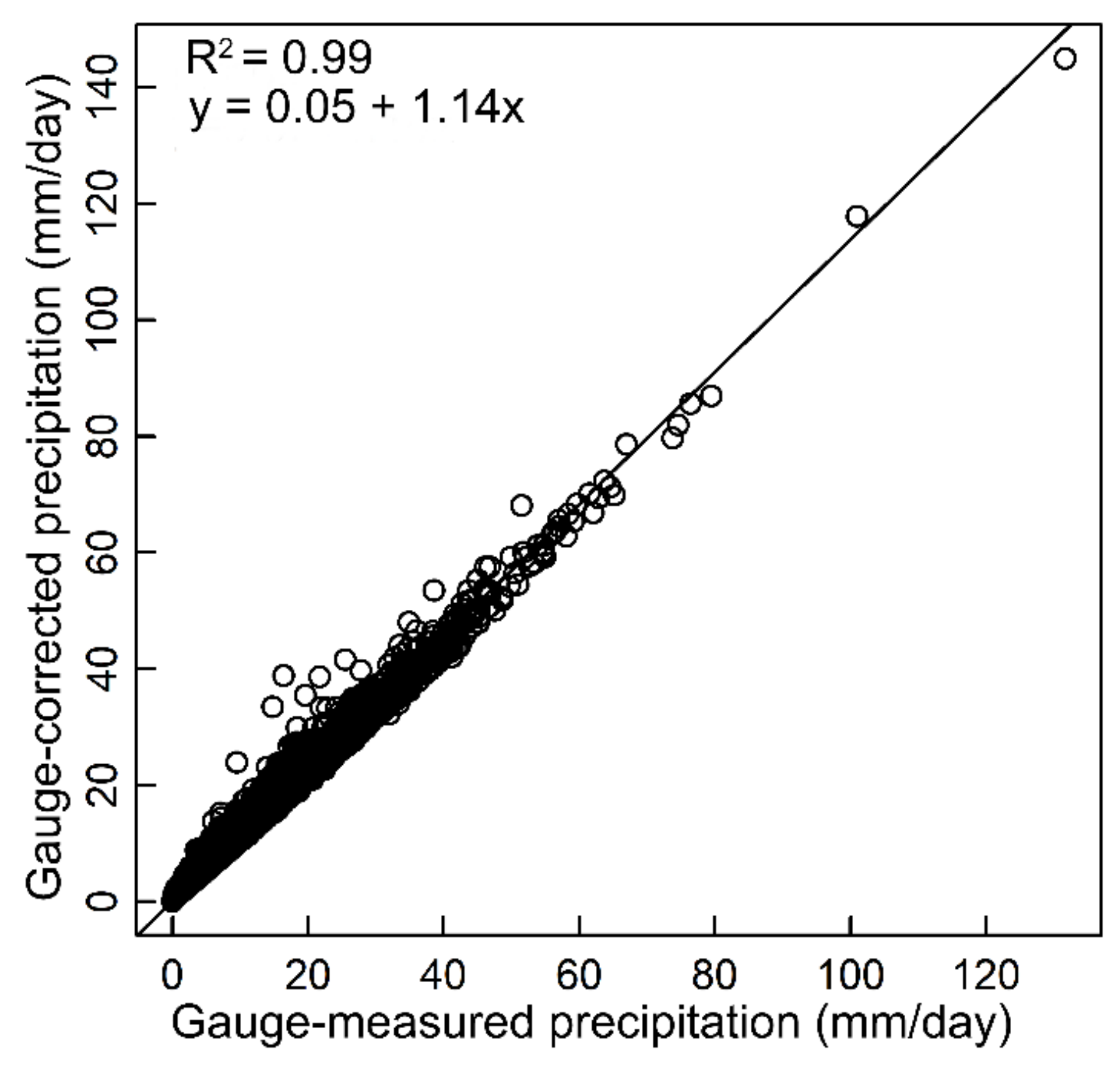
2.3.3. Bias-Correction Method
3. Results
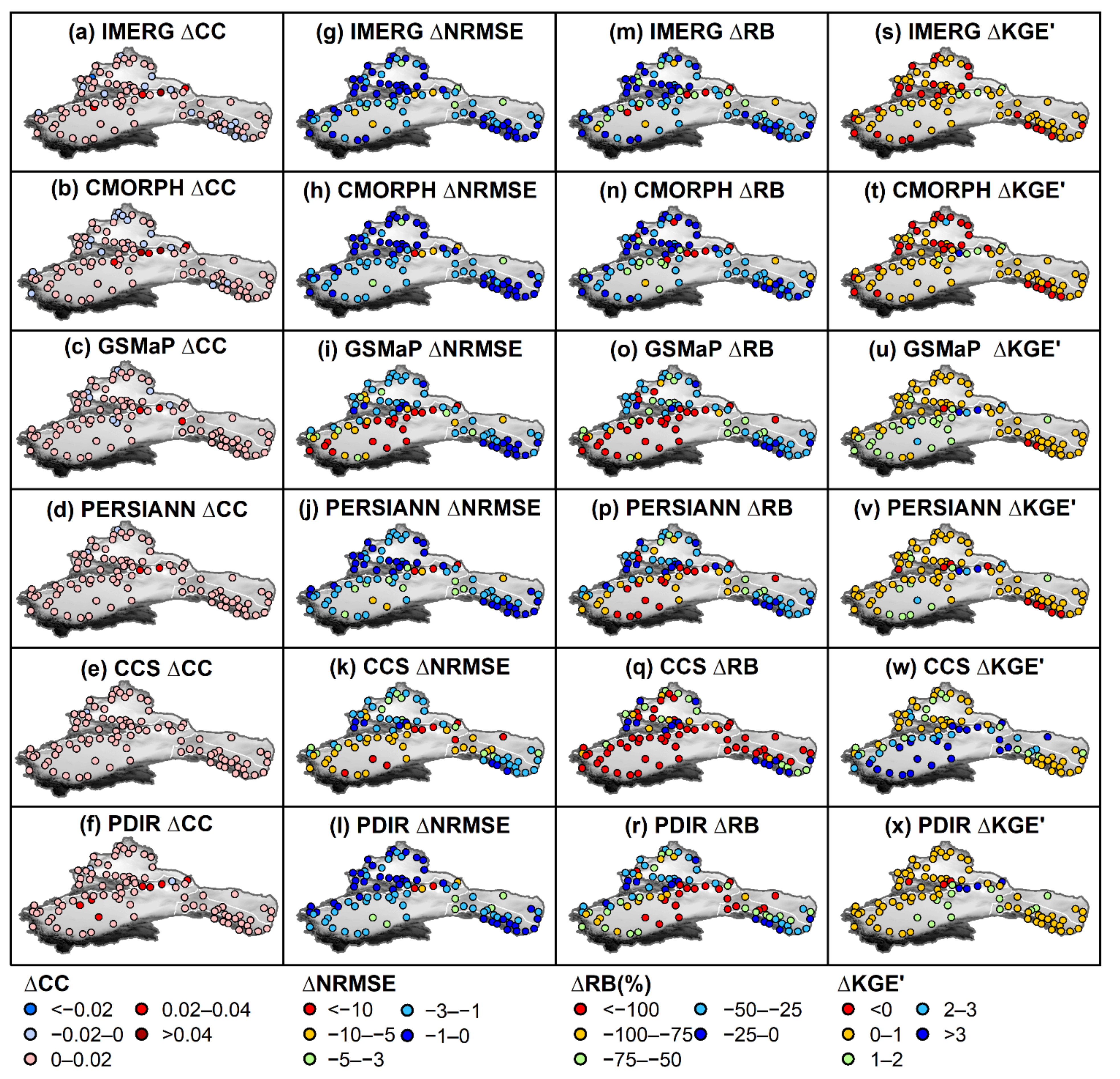
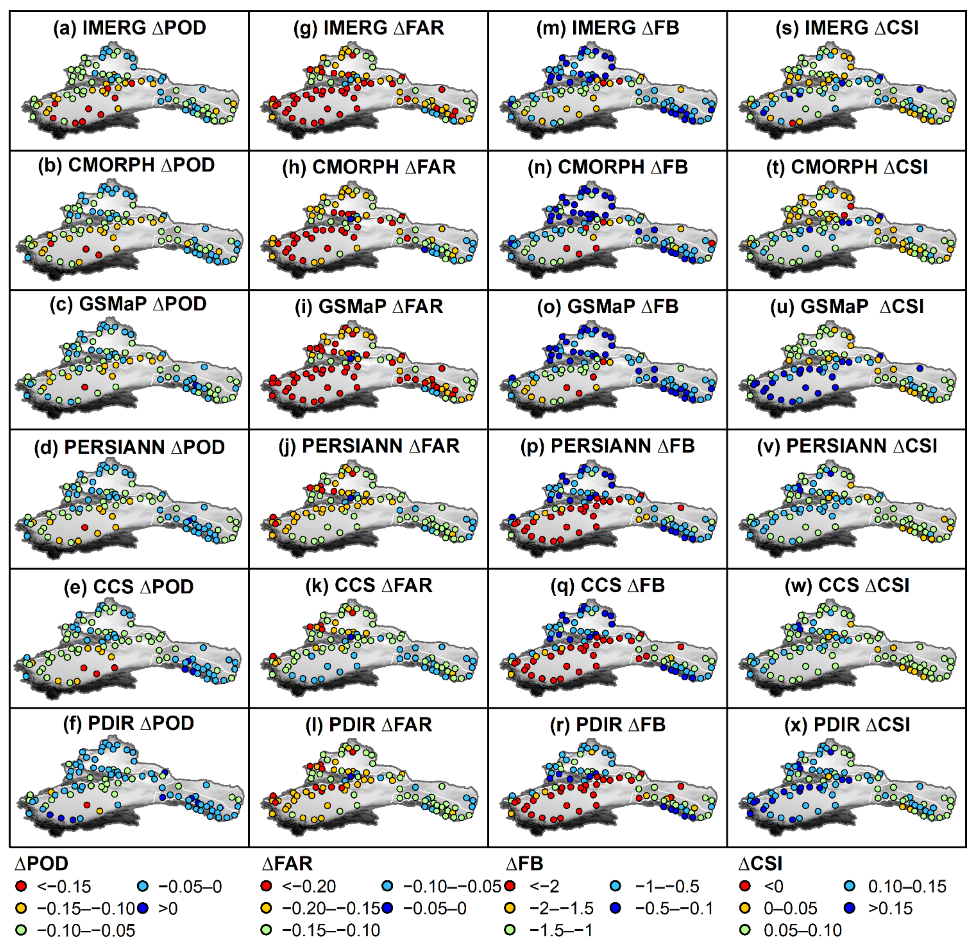
3.1. Spatial Variations of the Changes of Evaluation Metrics
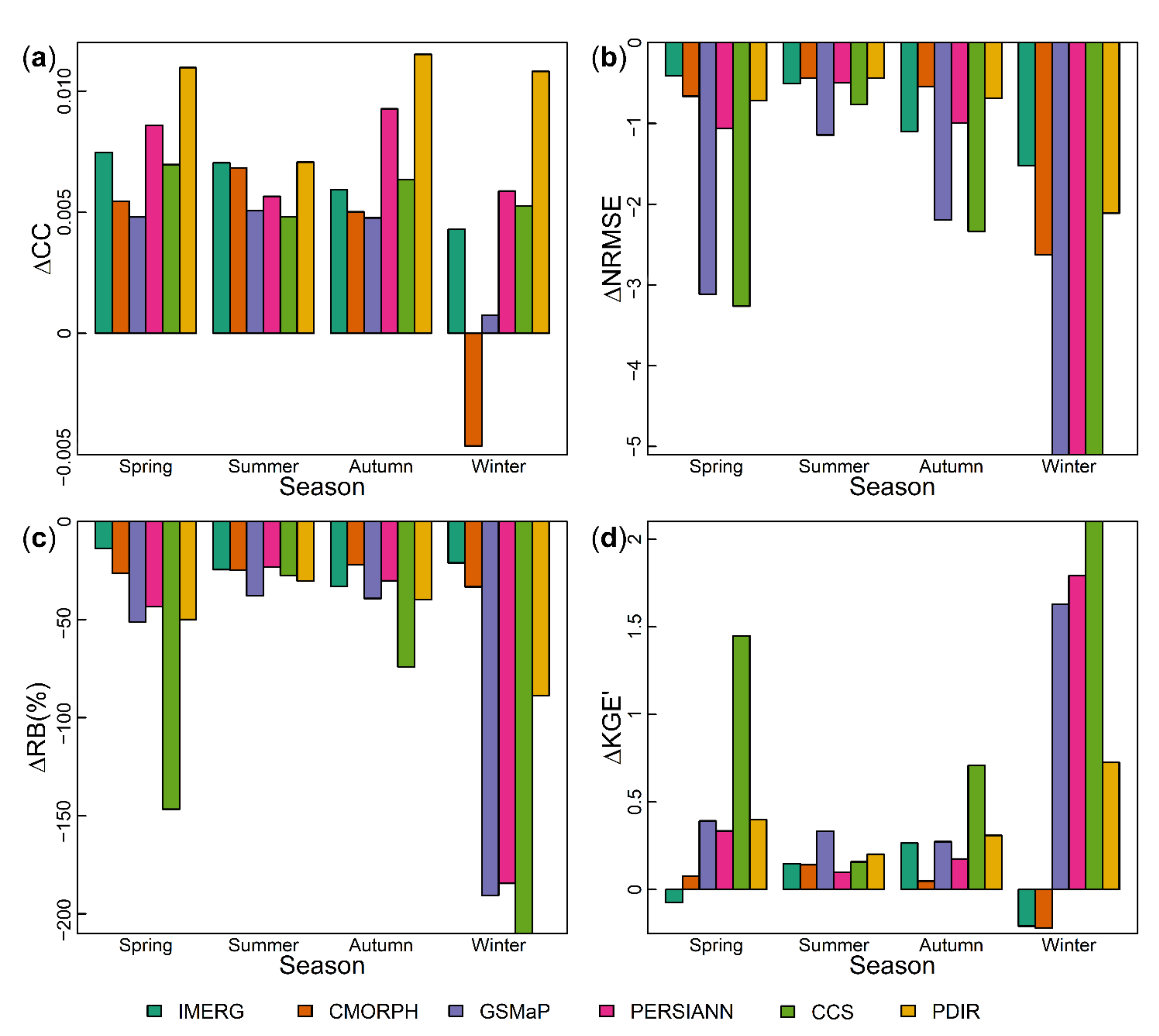
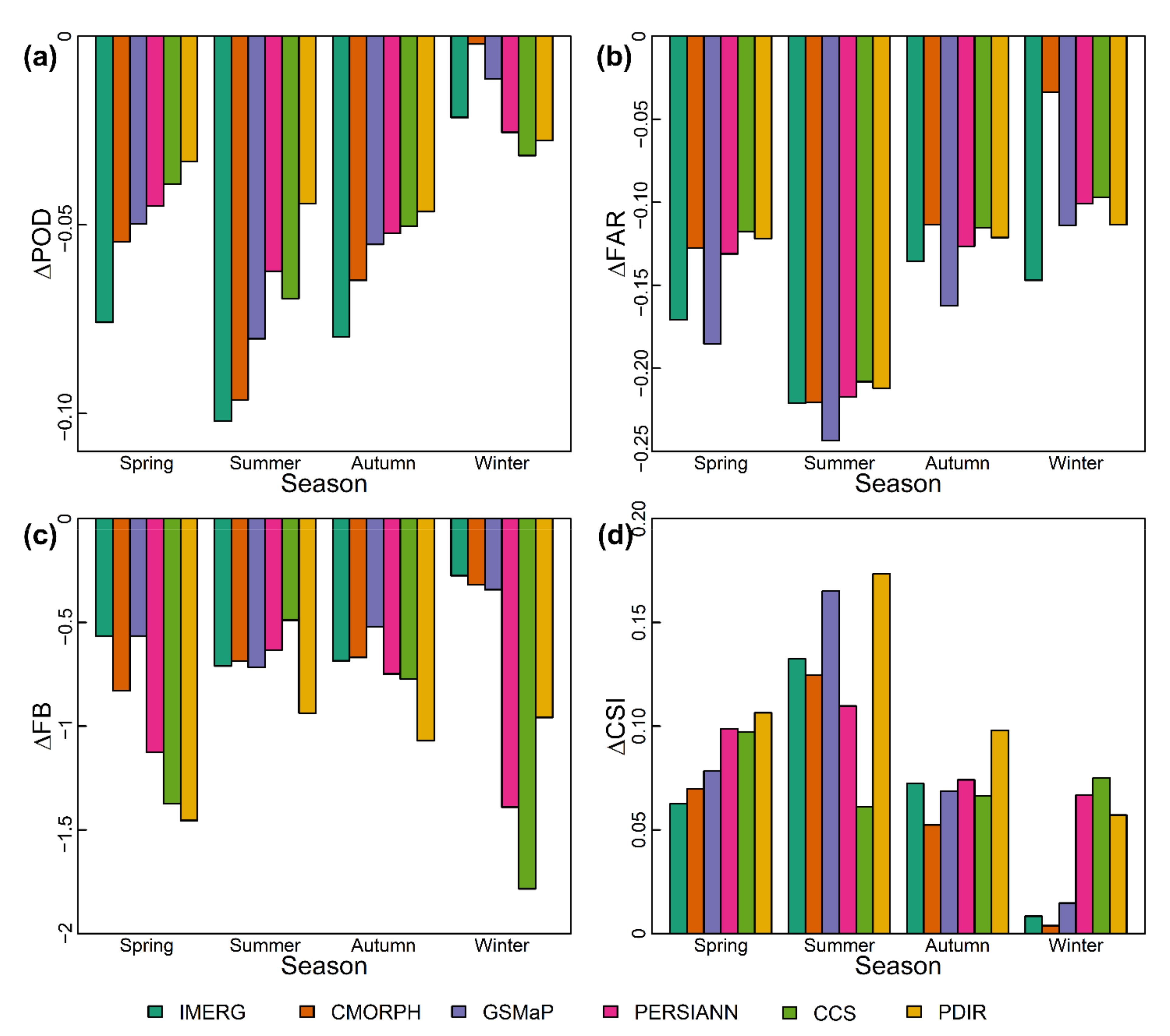
3.2. Seasonal Variations of the Changes of Evaluation Metrics
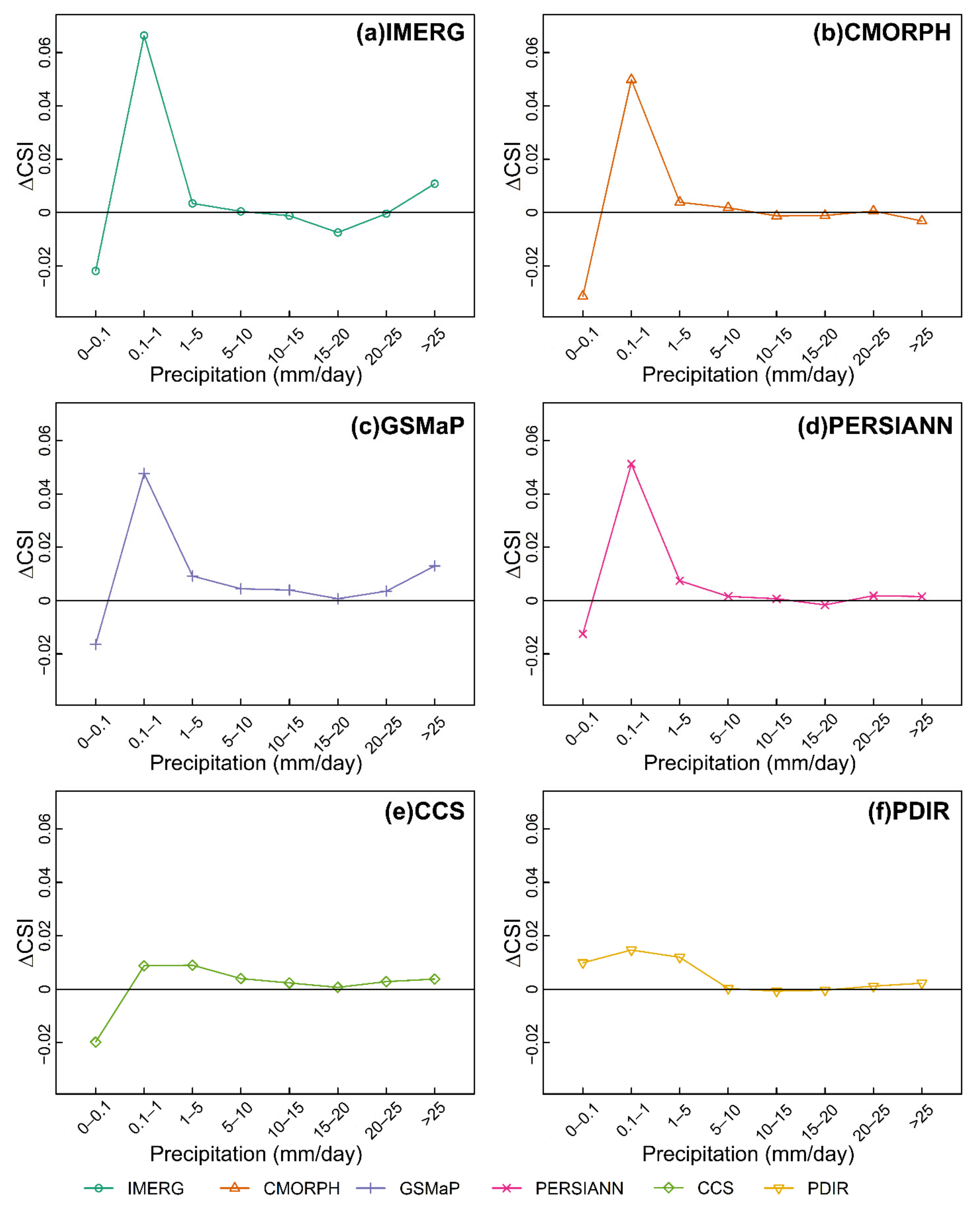
3.3. The Changes of Detection Ability for Different Ranges of Precipitation Intensity
3.4. The Changes of Accuracy for Different Precipitation Phases
3.5. The Performance of SPPs before Bias Correction and after Bias Correction
4. Summary and Discussion
5. Conclusions
- Over ARNC, the overall performances of six SPPs are undervalued by the gauge bias. For different aspects of performance, the bias makes the error, the probability of detection, and the false alarm rate of SPPs overvalued, and the relative bias and frequency bias undervalued. The correlation of SPPs is robust to the bias in gauge measurements;
- Whether before bias correction or after bias correction, the performance of IMERG is best over ARNC among six SPPs. PERSIANN, CCS, and PDIR, despite providing more precipitation details (higher resolution), do not show superior performance among the selected SPPs. The performances of all six SPPs are still not very satisfactory even after bias correction and needed to be improved for applications in ARNC;
- For different subregions, seasons, SPP, precipitation intensity, and precipitation phase, the impacts of gauge bias on the performance assessment are different. Among six subregions, the performance (accuracy and the detectability of precipitation events) assessment is most affected by gauge bias in SX. Compared to other SPPs, the accuracy of CCS and the detection ability of PDIR are the most undervalued, respectively. Each SPP shows a seasonal pattern of the impacts of bias, but the seasonal patterns vary across different SPPs. For different ranges of precipitation intensity, the detection ability of precipitation events with 0.1–1 mm/day for IMERG, CMORPH, GSMaP, and PERSIANN is significantly undervalued, but the impact of bias on the detection ability of precipitation events with >1 mm/day for six SPPs seems small. The impact of gauge bias on the accuracy assessment of snow estimation is more significant than that of rain estimation for six SPPs.
Author Contributions
Funding
Institutional Review Board Statement
Informed Consent Statement
Data Availability Statement
Acknowledgments
Conflicts of Interest
References
- Fang, J.; Yang, W.; Luan, Y.; Du, J.; Lin, A.; Zhao, L. Evaluation of the TRMM 3B42 and GPM IMERG products for extreme precipitation analysis over China. Atmos. Res. 2019, 223, 24–38. [Google Scholar] [CrossRef]
- Wei, L.; Jiang, S.; Ren, L.; Wang, M.; Zhang, L.; Liu, Y.; Yuan, F.; Yang, X. Evaluation of seventeen satellite-, reanalysis-, and gauge-based precipitation products for drought monitoring across mainland China. Atmos. Res. 2021, 263, 105813. [Google Scholar] [CrossRef]
- Maggioni, V.; Massari, C. On the performance of satellite precipitation products in riverine flood modeling: A review. J. Hydrol. 2018, 558, 214–224. [Google Scholar] [CrossRef]
- Alexander, S.; Block, P. Integration of seasonal precipitation forecast information into local-level agricultural decision-making using an agent-based model to support community adaptation. Clim. Risk Manag. 2022, 36, 100417. [Google Scholar] [CrossRef]
- Letu, H.; Yang, K.; Nakajima, T.Y.; Ishimoto, H.; Nagao, T.M.; Riedi, J.; Baran, A.J.; Ma, R.; Wang, T.; Shang, H.; et al. High-resolution retrieval of cloud microphysical properties and surface solar radiation using Himawari-8/AHI next-generation geostationary satellite. Remote Sens. Environ. 2020, 239, 111583. [Google Scholar] [CrossRef]
- Massari, C.; Brocca, L.; Pellarin, T.; Abramowitz, G.; Filippucci, P.; Ciabatta, L.; Maggioni, V.; Kerr, Y.; Fernandez Prieto, D. A daily 25 km short-latency rainfall product for data-scarce regions based on the integration of the Global Precipitation Measurement mission rainfall and multiple-satellite soil moisture products. Hydrol. Earth Syst. Sci. 2020, 24, 2687–2710. [Google Scholar] [CrossRef]
- Michaelides, S.; Levizzani, V.; Anagnostou, E.; Bauer, P.; Kasparis, T.; Lane, J.E. Precipitation: Measurement, remote sensing, climatology and modeling. Atmos. Res. 2009, 94, 512–533. [Google Scholar] [CrossRef]
- Huffman, G.J.; Adler, R.F.; Bolvin, D.T.; Nelkin, E.J. The TRMM Multi-Satellite Precipitation Analysis (TMPA). In Satellite Rainfall Applications for Surface Hydrology; Springer: Dordrecht, The Netherlands, 2010; pp. 3–22. [Google Scholar]
- Joyce, R.J.; Janowiak, J.E.; Arkin, P.A.; Xie, P. CMORPH: A Method that Produces Global Precipitation Estimates from Passive Microwave and Infrared Data at High Spatial and Temporal Resolution. J. Hydrometeorol. 2004, 5, 487–503. [Google Scholar] [CrossRef]
- Huffman, G.J.; Bolvin, D.T.; Braithwaite, D.; Hsu, K.-L.; Joyce, R.; Kidd, C.; Nelkin, E.J.; Sorooshian, S.; Tan, J.; Xie, P. Algorithm Theoretical Basis Document (ATBD) Version 06 NASA Global Precipitation Measurement (GPM) Integrated Multi-satellitE Retrievals for GPM (IMERG). Natl. Aeronaut. Space Adm. 2019, 1–34. [Google Scholar]
- Kubota, T.; Aonashi, K.; Ushio, T.; Shige, S.; Takayabu, Y.N.; Kachi, M.; Arai, Y.; Tashima, T.; Masaki, T.; Kawamoto, N.; et al. Global Satellite Mapping of Precipitation (GSMaP) Products in the GPM Era. In Satellite Precipitation Measurement; Springer: Cham, The Netherlands, 2020; pp. 355–373. [Google Scholar]
- Hsu, K.; Gao, X.; Sorooshian, S.; Gupta, H.V. Precipitation Estimation from Remotely Sensed Information Using Artificial Neural Networks. J. Appl. Meteorol. 1997, 36, 1176–1190. [Google Scholar] [CrossRef]
- Hong, Y.; Hsu, K.-L.; Sorooshian, S.; Gao, X. Precipitation Estimation from Remotely Sensed Imagery Using an Artificial Neural Network Cloud Classification System. J. Appl. Meteorol. 2004, 43, 1834–1853. [Google Scholar] [CrossRef] [Green Version]
- Nguyen, P.; Ombadi, M.; Gorooh, V.A.; Shearer, E.J.; Sadeghi, M.; Sorooshian, S.; Hsu, K.; Bolvin, D.; Ralph, M.F. PERSIANN Dynamic Infrared–Rain Rate (PDIR-Now): A Near-Real-Time, Quasi-Global Satellite Precipitation Dataset. J. Hydrometeorol. 2020, 21, 2893–2906. [Google Scholar] [CrossRef] [PubMed]
- Huang, A.; Zhao, Y.; Zhou, Y.; Yang, B.; Zhang, L.; Dong, X.; Fang, D.; Wu, Y. Evaluation of multisatellite precipitation products by use of ground-based data over China. J. Geophys. Res. Atmos. 2016, 121, 10654–10675. [Google Scholar] [CrossRef]
- Sharifi, E.; Steinacker, R.; Saghafian, B. Multi time-scale evaluation of high-resolution satellite-based precipitation products over northeast of Austria. Atmos. Res. 2018, 206, 46–63. [Google Scholar] [CrossRef]
- Alijanian, M.; Rakhshandehroo, G.R.; Mishra, A.K.; Dehghani, M. Evaluation of satellite rainfall climatology using CMORPH, PERSIANN-CDR, PERSIANN, TRMM, MSWEP over Iran. Int. J. Climatol. 2017, 37, 4896–4914. [Google Scholar] [CrossRef]
- Palomino-Ángel, S.; Anaya-Acevedo, J.A.; Botero, B.A. Evaluation of 3B42V7 and IMERG daily-precipitation products for a very high-precipitation region in northwestern South America. Atmos. Res. 2019, 217, 37–48. [Google Scholar] [CrossRef]
- Mahmoud, M.T.; Hamouda, M.A.; Mohamed, M.M. Spatiotemporal evaluation of the GPM satellite precipitation products over the United Arab Emirates. Atmos. Res. 2019, 219, 200–212. [Google Scholar] [CrossRef]
- Beck, H.E.; Vergopolan, N.; Pan, M.; Levizzani, V.; van Dijk, A.I.J.M.; Weedon, G.P.; Brocca, L.; Pappenberger, F.; Huffman, G.J.; Wood, E.F. Global-Scale Evaluation of 22 Precipitation Datasets Using Gauge Observations and Hydrological Modeling. In Satellite Precipitation Measurement; Springer: Cham, The Netherlands, 2020; pp. 625–653. [Google Scholar]
- Babaousmail, H.; Hou, R.; Ayugi, B.; Gnitou, G.T. Evaluation of satellite-based precipitation estimates over Algeria during 1998–2016. J. Atmos. Sol.-Terr. Phys. 2019, 195, 105139. [Google Scholar] [CrossRef]
- Yu, C.; Hu, D.; Liu, M.; Wang, S.; Di, Y. Spatio-temporal accuracy evaluation of three high-resolution satellite precipitation products in China area. Atmos. Res. 2020, 241, 104952. [Google Scholar] [CrossRef]
- Amjad, M.; Yilmaz, M.T.; Yucel, I.; Yilmaz, K.K. Performance evaluation of satellite- and model-based precipitation products over varying climate and complex topography. J. Hydrol. 2020, 584, 124707. [Google Scholar] [CrossRef]
- Sevruk, B. Adjustment of tipping-bucket precipitation gauge measurements. Atmos. Res. 1996, 42, 237–246. [Google Scholar] [CrossRef]
- Yang, D.; Ishida, S.; Goodison, B.E.; Gunther, T. Bias correction of daily precipitation measurements for Greenland. J. Geophys. Res. Atmos. 1999, 104, 6171–6181. [Google Scholar] [CrossRef]
- Ye, B.; Yang, D.; Ding, Y.; Han, T.; Koike, T. A Bias-Corrected Precipitation Climatology for China. J. Hydrometeorol. 2004, 5, 1147–1160. [Google Scholar] [CrossRef]
- Zhang, Y.; Ohata, T.; Yang, D.; Davaa, G. Bias correction of daily precipitation measurements for Mongolia. Hydrol. Process. 2004, 18, 2991–3005. [Google Scholar] [CrossRef]
- Goodison, B.E.; Louie, P.Y.T.; Yang, D. WMO solid precipitation measurement intercomparision. Instrum. Obs. Methods WMO 1998, 67, 212. [Google Scholar]
- Yang, D.; Kane, D.; Zhang, Z.; Legates, D.; Goodison, B. Bias corrections of long-term (1973–2004) daily precipitation data over the northern regions. Geophys. Res. Lett. 2005, 32, L19501. [Google Scholar] [CrossRef]
- Yang, D.; Wang, N.; Ye, B.; Ma, L. Recent advances in precipitation-bias correction and application. Sci. Cold Arid Reg. 2009, 1, 0193–0198. [Google Scholar]
- Li, N.; Li, Y.; Yao, N. Bias correction of the observed daily precipitation and re-division of climatic zones in China. Int. J. Climatol. 2018, 38, 3369–3387. [Google Scholar] [CrossRef]
- Yang, D. A case study of the wetting loss experiments in the rain gauge. Meteorol. Mon. 1987, 13, 16–18. [Google Scholar]
- Yang, D. Research on Analysis and Correction of Systematic Errors in Precipitation Measurement in Urumqi River Basin, Tianshan. Ph.D. Thesis, Lanzhou Institute of Glaciology and Geocryology, Lanzhou, China, 1988. [Google Scholar]
- Yang, D.; Shi, Y.; Kang, E.; Zhang, Y.; Yang, X. Results of solid precipitation measurement intercomparison in the alpine area of Urumqi River Basin. Chin. Sci. Bull. 1991, 36, 1105–1109. [Google Scholar]
- Yao, N.; Li, Y.; Li, N.; Yang, D.; Ayantobo, O.O. Bias correction of precipitation data and its effects on aridity and drought assessment in China over 1961–2015. Sci. Total Environ. 2018, 639, 1015–1027. [Google Scholar] [CrossRef] [PubMed]
- Zhang, L.; Gao, L.; Zhao, L.; Qiao, Y.; Shi, J. Review on correction of errors in precipitation measurement. Adv. Earth Sci. 2017, 32, 723–730. [Google Scholar]
- Zhang, Y.; Ren, Y.; Ren, G.; Wang, G. Bias Correction of Gauge Data and its Effect on Precipitation Climatology over Mainland China. J. Appl. Meteorol. Climatol. 2019, 58, 2177–2196. [Google Scholar] [CrossRef]
- Deng, X.; Liu, Y.; Liu, Z.; Yao, J. Temporal-spatial dynamic change characteristics of evapotranspiration in arid region of Northwest China. Acta Ecol. Sin. 2017, 37, 2994–3008. [Google Scholar]
- Ma, L.; Zhang, T.; Frauenfeld, O.W.; Ye, B.; Yang, D.; Qin, D. Evaluation of precipitation from the ERA-40, NCEP-1, and NCEP-2 Reanalyses and CMAP-1, CMAP-2, and GPCP-2 with ground-based measurements in China. J. Geophys. Res. 2009, 114, D09105. [Google Scholar] [CrossRef]
- Liu, Y.; Yu, E.; Yang, J.; Huang, W. Characteristics of Spatial and Temporal Variation of Actual Evapotranspiration in the Arid Region of Northwest China from 1960 to 2019. Res. Soil Water Conserv. 2021, 28, 75–80. [Google Scholar] [CrossRef]
- Yao, J.; Yang, Q.; Liu, Z.; Li, C. Spatial-temporal change of precipitation in arid region of the Northwest China. Acta Ecol. Sin. 2015, 35, 5846–5855. [Google Scholar]
- Schneider, U.; Finger, P.; Rustemeier, E.; Ziese, M.; Becker, A. Global Precipitation Analysis Products of the GPCC. Glob. Precip. Climatol. Centr. 2021, 17. [Google Scholar]
- Xie, P.; Joyce, R.; Wu, S.; Yoo, S.-H.; Yarosh, Y.; Sun, F.; Lin, R. Reprocessed, Bias-Corrected CMORPH Global High-Resolution Precipitation Estimates from 1998. J. Hydrometeorol. 2017, 18, 1617–1641. [Google Scholar] [CrossRef]
- Aonashi, K.; Awaka, J.; Hirose, M.; Kozu, T.; Kubota, T.; Liu, G.; Shige, S.; Kida, S.; Seto, S.; Takahashi, N.; et al. GSMaP Passive Microwave Precipitation Retrieval Algorithm: Algorithm Description and Validation. J. Meteorol. Soc. Jpn. Ser. II 2009, 87, 119–136. [Google Scholar] [CrossRef] [Green Version]
- Ushio, T.; Sasashige, K.; Kubota, T.; Shige, S.; Okamoto, K.; Aonashi, K.; Inoue, T.; Takahashi, N.; Iguchi, T.; Kachi, M.; et al. A Kalman Filter Approach to the Global Satellite Mapping of Precipitation (GSMaP) from Combined Passive Microwave and Infrared Radiometric Data. J. Meteorol. Soc. Jpn. Ser. II 2009, 87, 137–151. [Google Scholar] [CrossRef] [Green Version]
- Mega, T.; Ushio, T.; Takahiro, M.; Kubota, T.; Kachi, M.; Oki, R. Gauge-Adjusted Global Satellite Mapping of Precipitation. IEEE Trans. Geosci. Remote Sens. 2019, 57, 1928–1935. [Google Scholar] [CrossRef]
- Kobayashi, S.; Ota, Y.; Harada, Y.; Ebita, A.; Moriya, M.; Onoda, H.; Onogi, K.; Kamahori, H.; Kobayashi, C.; Endo, H.; et al. The JRA-55 Reanalysis: General Specifications and Basic Characteristics. J. Meteorol. Soc. Jpn. Ser. II 2015, 93, 5–48. [Google Scholar] [CrossRef] [Green Version]
- Baez-Villanueva, O.M.; Zambrano-Bigiarini, M.; Ribbe, L.; Nauditt, A.; Giraldo-Osorio, J.D.; Thinh, N.X. Temporal and spatial evaluation of satellite rainfall estimates over different regions in Latin-America. Atmos. Res. 2018, 213, 34–50. [Google Scholar] [CrossRef]
- Guo, H.; Chen, S.; Bao, A.; Hu, J.; Gebregiorgis, A.; Xue, X.; Zhang, X. Inter-Comparison of High-Resolution Satellite Precipitation Products over Central Asia. Remote Sens. 2015, 7, 7181–7211. [Google Scholar] [CrossRef] [Green Version]
- Mekonnen, K.; Melesse, A.M.; Woldesenbet, T.A. Spatial evaluation of satellite-retrieved extreme rainfall rates in the Upper Awash River Basin, Ethiopia. Atmos. Res. 2021, 249, 105297. [Google Scholar] [CrossRef]
- Wang, G.; Zhang, X.; Zhang, S. Performance of Three Reanalysis Precipitation Datasets over the Qinling-Daba Mountains, Eastern Fringe of Tibetan Plateau, China. Adv. Meteorol. 2019, 2019, 7698171. [Google Scholar] [CrossRef] [Green Version]
- Tang, G.; Clark, M.P.; Papalexiou, S.M.; Ma, Z.; Hong, Y. Have satellite precipitation products improved over last two decades? A comprehensive comparison of GPM IMERG with nine satellite and reanalysis datasets. Remote Sens. Environ. 2020, 240, 111697. [Google Scholar] [CrossRef]
- Yang, M.; Liu, G.; Chen, T.; Chen, Y.; Xia, C. Evaluation of GPM IMERG precipitation products with the point rain gauge records over Sichuan, China. Atmos. Res. 2020, 246, 105101. [Google Scholar] [CrossRef]
- Zhang, L.; Li, X.; Cao, Y.; Nan, Z.; Wang, W.; Ge, Y.; Wang, P.; Yu, W. Evaluation and integration of the top-down and bottom-up satellite precipitation products over mainland China. J. Hydrol. 2020, 581, 124456. [Google Scholar] [CrossRef]
- Yang, D.; Jiang, T.; Zhang, Y.; Kang, E. Analysis and Correction of Errors in Precipitation Measurement at the Head of Urumqi River, Tianshan. J. Glaciol. Geocryol. 1988, 10, 384–399. [Google Scholar]
- Sevruk, B.; Hamon, W. International comparison of national precipitation gauges with a reference pit gauge. WMO Instrum. Obs. Methods Rep. 1984, 17, 111. [Google Scholar]
- Dinku, T.; Ceccato, P.; Connor, S.J. Challenges of satellite rainfall estimation over mountainous and arid parts of east Africa. Int. J. Remote Sens. 2011, 32, 5965–5979. [Google Scholar] [CrossRef]
- Joyce, R.J.; Xie, P. Kalman Filter–Based CMORPH. J. Hydrometeorol. 2011, 12, 1547–1563. [Google Scholar] [CrossRef]
- Sevruk, B. Method of Correction for Systematic Error in Point Precipitation Measurement for Operational Use; WMO. Tech. Doc.; WMO: Geneva, Switzerland, 1982; 91p. [Google Scholar]


| Dataset | Version | Resolution | Period | Reference |
|---|---|---|---|---|
| IMERG | Final Run v06B IMERG_uncal | 0.1°/0.5 h | 2003–2015 | Huffman et al. [10] |
| CMORPH | V1.0 Raw, satellite-only | 0.25°/3 h | 2003–2015 | Joyce et al. [9] |
| GSMaP | GSMaP_MVK v7/GSMaP_RNL v6 | 0.1°/1 d | 2003–2015 | Kubota et al. [11] |
| PERSIANN | — | 0.25°/6 h | 2003–2015 | Hsu et al. [12] |
| PERSIANN−CCS | — | 0.04°/6 h | 2003–2015 | Hong et al. [13] |
| PDIR−Now | — | 0.04°/6 h | 2003–2015 | Nguyen et al. [14] |
| Name | Formula | Optimal Value | Value Range |
|---|---|---|---|
| Correlation coefficient/CC | 1 | [0, 1] | |
| Relative bias/RB | 0 | (−∞,+∞) | |
| Normalized root mean square error/NRMSE | 0 | (−∞,+∞) | |
| Modified Kling–Gupta efficiency/KGE′ | 1 | (−∞,1] | |
| Probability of detection/POD | 1 | [0, 1] | |
| False alarm ratio/FAR | 0 | [0, 1] | |
| Frequency bias/FB | 0 | (−∞,+∞) | |
| Critical success index/CSI | 1 | [0, 1] |
| Subregion | NX | TM | SX | QM | HC | AP | ARNC | |
|---|---|---|---|---|---|---|---|---|
| ∆CC | IMERG | 0.004 | 0.004 | 0.010 | 0.005 | 0.003 | 0.009 | 0.005 |
| CMORPH | 0.002 | 0.001 | 0.013 | 0.002 | 0.005 | 0.005 | 0.004 | |
| GSMaP | 0.005 | 0.002 | 0.006 | 0.005 | 0.006 | 0.008 | 0.004 | |
| PERSIANN | 0.006 | 0.003 | 0.010 | 0.007 | 0.008 | 0.009 | 0.007 | |
| CCS | 0.007 | 0.004 | 0.005 | 0.005 | 0.007 | 0.007 | 0.005 | |
| PDIR | 0.009 | 0.006 | 0.015 | 0.001 | 0.008 | 0.012 | 0.008 | |
| Mean | 0.006 | 0.003 | 0.010 | 0.004 | 0.006 | 0.008 | 0.006 | |
| ∆NRMSE | IMERG | −0.81 | −0.27 | −2.19 | −0.23 | −1.05 | −0.89 | −0.77 |
| CMORPH | −0.77 | −0.32 | −1.68 | −0.14 | −0.78 | −0.74 | −0.66 | |
| GSMaP | −2.35 | −1.11 | −9.52 | −0.41 | −1.51 | −1.16 | −2.63 | |
| PERSIANN | −1.10 | −0.39 | −2.60 | −0.30 | −1.22 | −0.97 | −0.98 | |
| CCS | −2.39 | −1.37 | −7.03 | −0.81 | −2.90 | −2.55 | −2.54 | |
| PDIR | −0.71 | −0.27 | −1.70 | −0.27 | −1.13 | −0.75 | −0.70 | |
| Mean | −1.36 | −0.62 | −4.12 | −0.36 | −1.43 | −1.18 | −1.38 | |
| ∆RB | IMERG | −28.5% | −15.9% | −41.6% | −14.4% | −32.3% | −28.5% | −25.0% |
| CMORPH | −29.2% | −17.2% | −40.7% | −14.8% | −32.4% | −39.1% | −25.8% | |
| GSMaP | −52.6% | −33.2% | −122.1% | −20.8% | −38.3% | −36.5% | −48.7% | |
| PERSIANN | −41.8% | −19.7% | −86.8% | −15.1% | −39.3% | −33.3% | −36.5% | |
| CCS | −93.6% | −53.1% | −266.8% | −33.6% | −101.2% | −87.6% | −95.6% | |
| PDIR | −45.1% | −20.4% | −81.4% | −21.8% | −53.5% | −41.6% | −40.1% | |
| Mean | −48.5% | −26.6% | −106.6% | −20.1% | −49.5% | −44.4% | −45.3% | |
| ∆KGE′ | IMERG | 0.10 | −0.02 | 0.33 | −0.08 | 0.26 | 0.20 | 0.09 |
| CMORPH | 0.11 | −0.01 | 0.31 | −0.04 | 0.21 | 0.30 | 0.10 | |
| GSMaP | 0.43 | 0.26 | 1.19 | 0.04 | 0.31 | 0.30 | 0.40 | |
| PERSIANN | 0.31 | 0.04 | 0.83 | −0.04 | 0.29 | 0.21 | 0.26 | |
| CCS | 0.91 | 0.49 | 2.66 | 0.23 | 0.98 | 0.84 | 0.93 | |
| PDIR | 0.34 | 0.04 | 0.76 | 0.07 | 0.47 | 0.32 | 0.30 | |
| Mean | 0.37 | 0.13 | 1.01 | 0.03 | 0.42 | 0.36 | 0.35 | |
| Subregion | NX | TM | SX | QM | HC | AP | ARNC | |
|---|---|---|---|---|---|---|---|---|
| ∆POD | IMERG | −0.06 | −0.07 | −0.12 | −0.05 | −0.07 | −0.08 | −0.08 |
| CMORPH | −0.04 | −0.06 | −0.10 | −0.03 | −0.07 | −0.04 | −0.07 | |
| GSMaP | −0.05 | −0.06 | −0.08 | −0.04 | −0.05 | −0.06 | −0.06 | |
| PERSIANN | −0.04 | −0.06 | −0.08 | −0.02 | −0.04 | −0.06 | −0.05 | |
| CCS | −0.05 | −0.05 | −0.09 | −0.01 | −0.03 | −0.04 | −0.05 | |
| PDIR | −0.04 | −0.05 | −0.05 | −0.03 | −0.03 | −0.04 | −0.04 | |
| Mean | −0.05 | −0.06 | −0.09 | −0.03 | −0.05 | −0.05 | −0.06 | |
| ∆FAR | IMERG | −0.19 | −0.13 | −0.26 | −0.09 | −0.18 | −0.15 | −0.18 |
| CMORPH | −0.18 | −0.12 | −0.25 | −0.08 | −0.12 | −0.08 | −0.15 | |
| GSMaP | −0.21 | −0.14 | −0.28 | −0.09 | −0.20 | −0.16 | −0.20 | |
| PERSIANN | −0.17 | −0.12 | −0.15 | −0.09 | −0.13 | −0.10 | −0.15 | |
| CCS | −0.17 | −0.12 | −0.12 | −0.09 | −0.11 | −0.08 | −0.13 | |
| PDIR | −0.17 | −0.13 | −0.17 | −0.09 | −0.13 | −0.10 | −0.15 | |
| Mean | −0.18 | −0.13 | −0.21 | −0.09 | −0.15 | −0.11 | −0.16 | |
| ∆FB | IMERG | −0.52 | −0.44 | −1.13 | −0.21 | −0.65 | −0.65 | −0.60 |
| CMORPH | −0.45 | −0.43 | −1.11 | −0.31 | −0.93 | −1.40 | −0.66 | |
| GSMaP | −0.44 | −0.41 | −1.28 | −0.22 | −0.60 | −0.65 | −0.58 | |
| PERSIANN | −0.70 | −0.51 | −2.45 | −0.24 | −0.91 | −0.94 | −0.90 | |
| CCS | −0.69 | −0.54 | −2.70 | −0.24 | −1.11 | −1.16 | −0.97 | |
| PDIR | −0.87 | −0.63 | −2.73 | −0.29 | −1.24 | −1.29 | −1.09 | |
| Mean | −0.61 | −0.49 | −1.90 | −0.25 | −0.91 | −1.02 | −0.80 | |
| ∆CSI | IMERG | 0.08 | 0.06 | 0.10 | 0.03 | 0.09 | 0.08 | 0.07 |
| CMORPH | 0.05 | 0.05 | 0.10 | 0.05 | 0.07 | 0.06 | 0.06 | |
| GSMaP | 0.07 | 0.05 | 0.15 | 0.03 | 0.10 | 0.09 | 0.09 | |
| PERSIANN | 0.10 | 0.06 | 0.11 | 0.04 | 0.08 | 0.06 | 0.09 | |
| CCS | 0.10 | 0.07 | 0.09 | 0.04 | 0.07 | 0.06 | 0.08 | |
| PDIR | 0.12 | 0.09 | 0.14 | 0.06 | 0.10 | 0.08 | 0.11 | |
| Mean | 0.09 | 0.06 | 0.12 | 0.04 | 0.09 | 0.07 | 0.08 | |
| Metrics | Type | IMERG | CMORPH | GSMaP | PERSIANN | CCS | PDIR |
|---|---|---|---|---|---|---|---|
| ∆CC | Rain | 0.007 | 0.007 | 0.006 | 0.007 | 0.004 | 0.009 |
| Mixed | 0.005 | 0.004 | 0.003 | 0.009 | 0.006 | 0.016 | |
| Snow | 0.006 | −0.001 | 0.000 | 0.008 | 0.006 | 0.014 | |
| ∆NRMSE | Rain | −0.65 | −0.53 | −1.69 | −0.66 | −1.52 | −0.55 |
| Mixed | −0.50 | −0.48 | −3.76 | −1.24 | −3.70 | −0.64 | |
| Snow | −1.34 | −1.84 | −13.42 | −4.46 | −13.75 | −1.68 | |
| ∆RB | Rain | −24.7% | −24.9% | −41.1% | −28.3% | −57.9% | −35.8% |
| Mixed | −13.1% | −17.9% | −38.6% | −40.1% | −157.9% | −35.4% | |
| Snow | −21.6% | −26.3% | −135.4% | −128.2% | −531.2% | −78.6% | |
| ∆KGE′ | Rain | 0.14 | 0.13 | 0.36 | 0.17 | 0.54 | 0.27 |
| Mixed | −0.10 | −0.03 | 0.03 | 0.28 | 1.56 | 0.21 | |
| Snow | −0.21 | −0.22 | 0.94 | 1.20 | 5.30 | 0.62 |
| Product | IMERG | CMORPH | GSMaP | PERSIANN | CCS | PDIR | |
|---|---|---|---|---|---|---|---|
| RB | RB_B | 28.8% | 33.1% | 150.9% | 88.2% | 393.2% | 106.9% |
| RB_A | 3.8% | 7.3% | 102.3% | 51.7% | 297.5% | 66.8% | |
| KGE′ | KGE′_B | 0.40 | 0.27 | −0.69 | −0.20 | −3.05 | −0.38 |
| KGE′_A | 0.49 | 0.37 | −0.29 | 0.06 | −2.12 | −0.08 | |
| FB | FB_B | 0.57 | 0.71 | 0.50 | 1.34 | 1.52 | 1.84 |
| FB_A | −0.04 | 0.05 | −0.08 | 0.44 | 0.55 | 0.74 | |
| CSI | CSI_B | 0.35 | 0.28 | 0.34 | 0.25 | 0.23 | 0.26 |
| CSI_A | 0.42 | 0.34 | 0.43 | 0.34 | 0.31 | 0.37 | |
Publisher’s Note: MDPI stays neutral with regard to jurisdictional claims in published maps and institutional affiliations. |
© 2022 by the authors. Licensee MDPI, Basel, Switzerland. This article is an open access article distributed under the terms and conditions of the Creative Commons Attribution (CC BY) license (https://creativecommons.org/licenses/by/4.0/).
Share and Cite
Xie, W.; Yi, S.; Leng, C. Impacts of Gauge Data Bias on the Performance Evaluation of Satellite-Based Precipitation Products in the Arid Region of Northwestern China. Water 2022, 14, 1860. https://doi.org/10.3390/w14121860
Xie W, Yi S, Leng C. Impacts of Gauge Data Bias on the Performance Evaluation of Satellite-Based Precipitation Products in the Arid Region of Northwestern China. Water. 2022; 14(12):1860. https://doi.org/10.3390/w14121860
Chicago/Turabian StyleXie, Wenhao, Shanzhen Yi, and Chuang Leng. 2022. "Impacts of Gauge Data Bias on the Performance Evaluation of Satellite-Based Precipitation Products in the Arid Region of Northwestern China" Water 14, no. 12: 1860. https://doi.org/10.3390/w14121860
APA StyleXie, W., Yi, S., & Leng, C. (2022). Impacts of Gauge Data Bias on the Performance Evaluation of Satellite-Based Precipitation Products in the Arid Region of Northwestern China. Water, 14(12), 1860. https://doi.org/10.3390/w14121860