Spatial Differentiation of Pond Landscapes across an Urban-Rural Gradient in the Pearl River Delta Region
Abstract
1. Introduction
2. Materials and Methods
2.1. Study Area
2.2. Data Sources and Processing
2.2.1. Google Imagery
2.2.2. Ponds Labels
2.3. Ponds Extraction Method and Evaluation Metrics
2.3.1. Ponds Extraction Method
2.3.2. Evaluation Metrics
2.4. Urban-Rural Gradient Classification Method
- Indicator selection, including three land use cover indicators and four landscape model variable indicators: construction land (X1), construction land core area (X2), construction land islet (X3), woodland (X4), woodland core area (X5), woodland islet (X6), and cultivated land (X7). The landscape model variable indicators (X2, X3, X5 and X6) were analysed using the GuidosToolbox (GTB3.0) software [47]. The proportion (%) of the total land area of the town represented by each land use was used for analysis. The above data were based on interpretation of the 2020 Remote Sensing Monitoring Data Set of China Multi-Period Land Use/Cover Change Data Set, with a spatial resolution of 30 m.
- Principal component analysis (PCA): SPSS software (IBM, Armonk, NY, USA) was used to conduct a PCA on the above seven indicators, and take the index whose initial eigenvector is larger than 1 as the principal component.
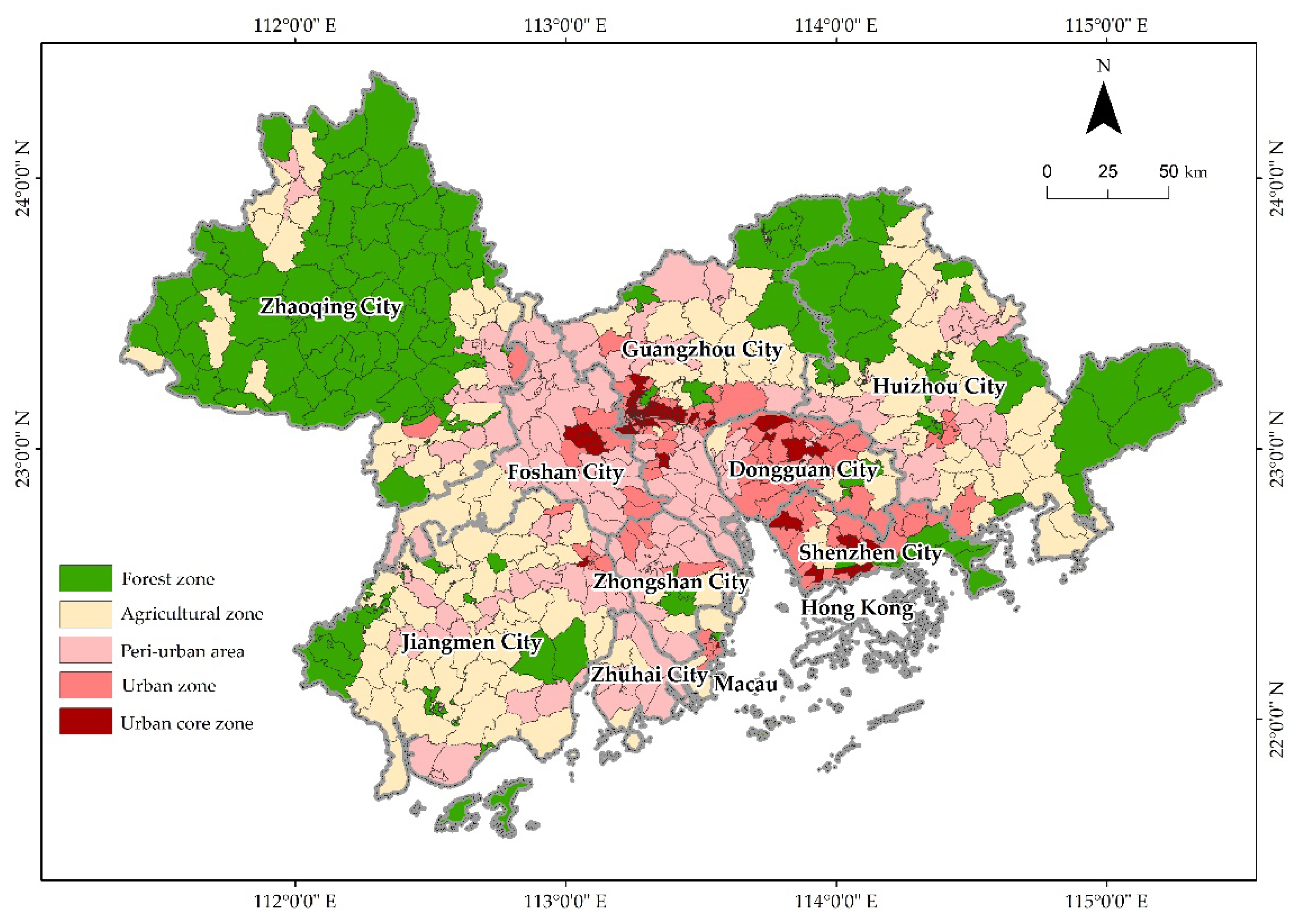
- Grouping and clustering: based on the results of the PCA, the Spatial Analyst extension module of ArcGIS 10.2 (ESRI, Redlands, CA, USA) was applied for grouping and clustering (using grouping rules that are not constrained by space), and the 665 towns were divided into five types alone the urban-rural gradient. According to the urbanisation characteristics of the PRD, these were urban core, urban, peri-urban, agricultural, and forest zone. The gradual transition from the urban core to the forest represents a gradual reduction in the influence of human activities on the landscape.
2.5. Quantification of Spatial Differentiation
3. Results
3.1. Assessment of Ponds Mapping Result
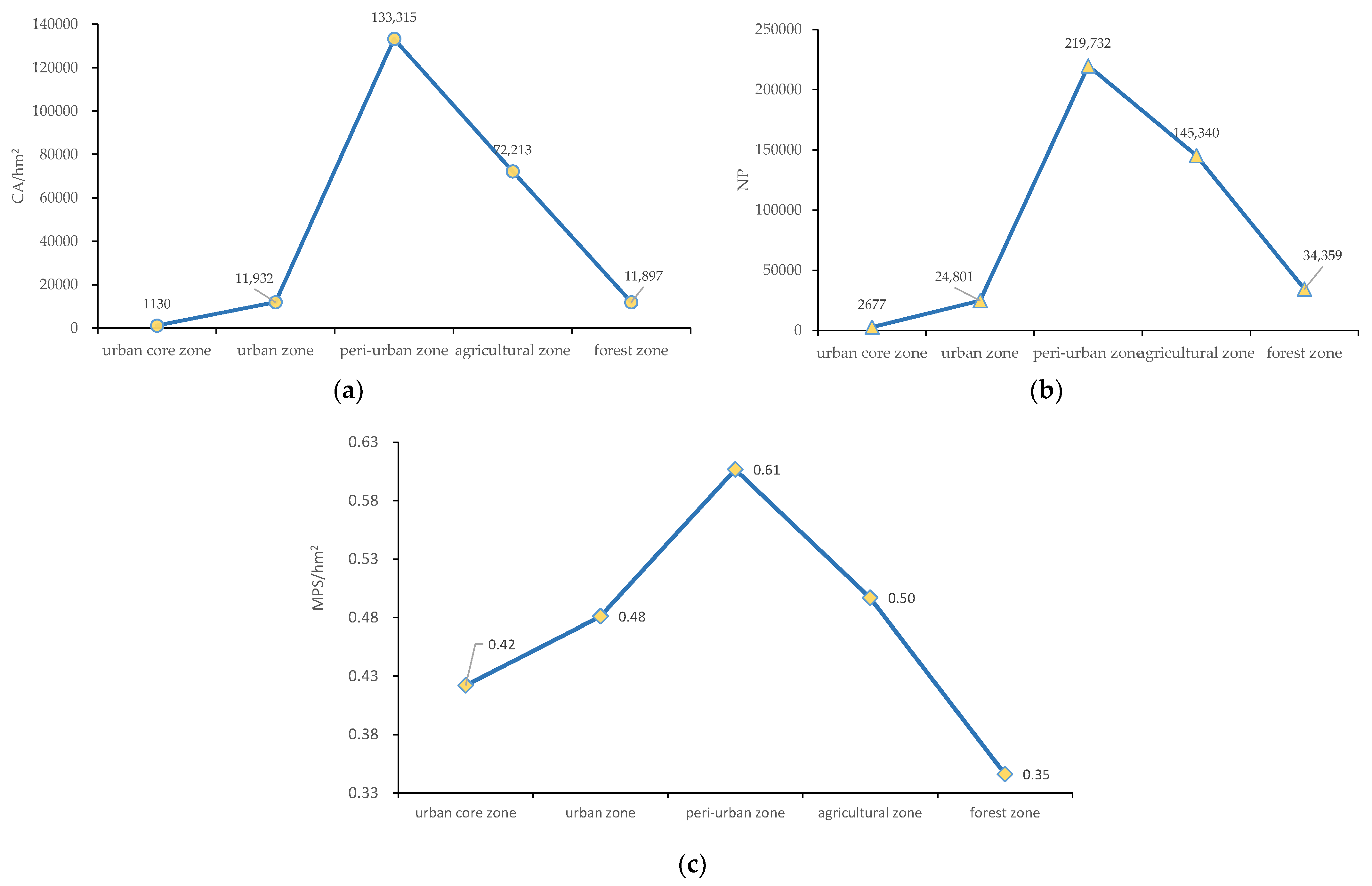
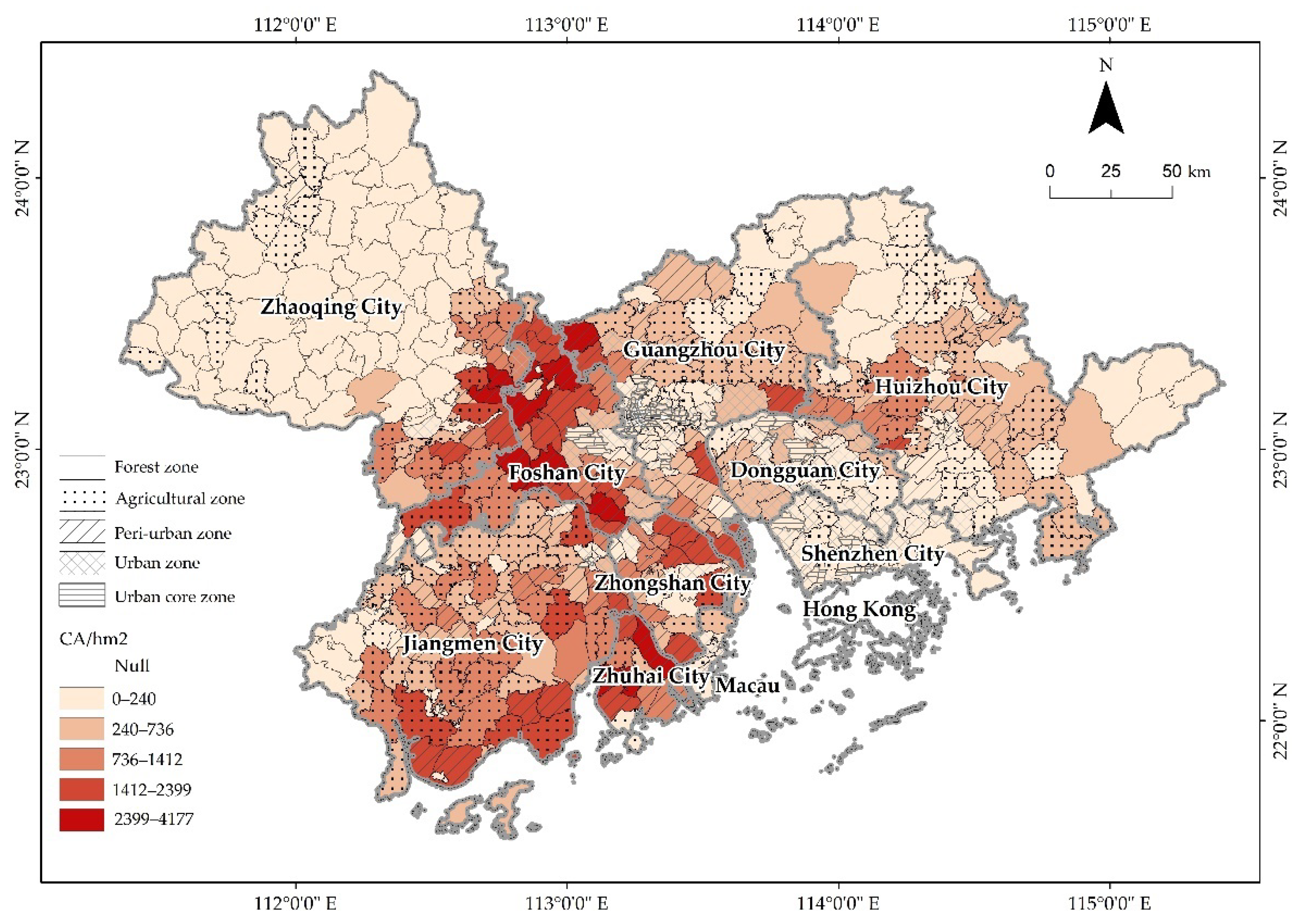
3.2. Urban-Rural Gradient Division of PRD with Towns as Units and Overall Characteristics of the Pond Landscape
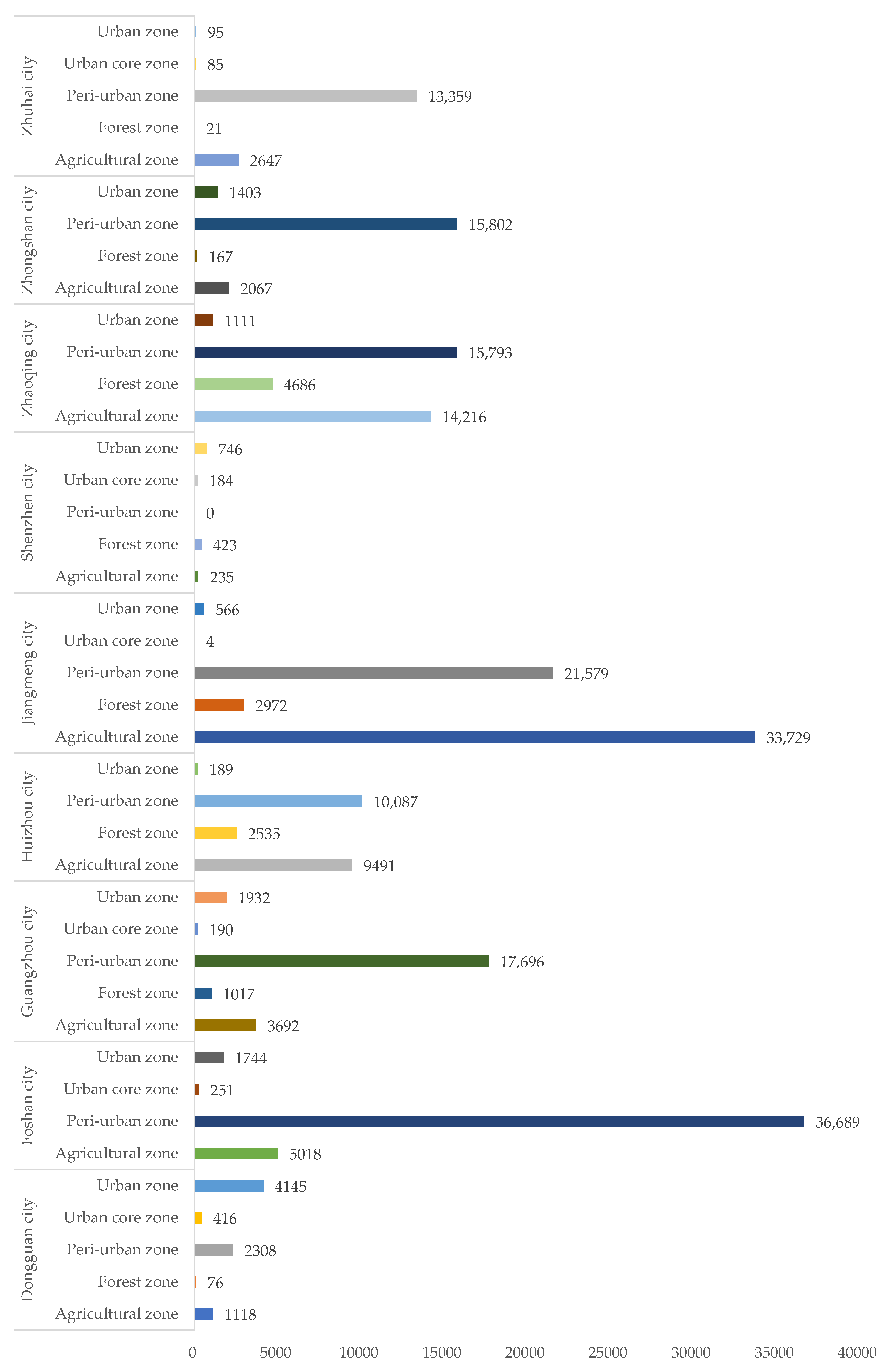
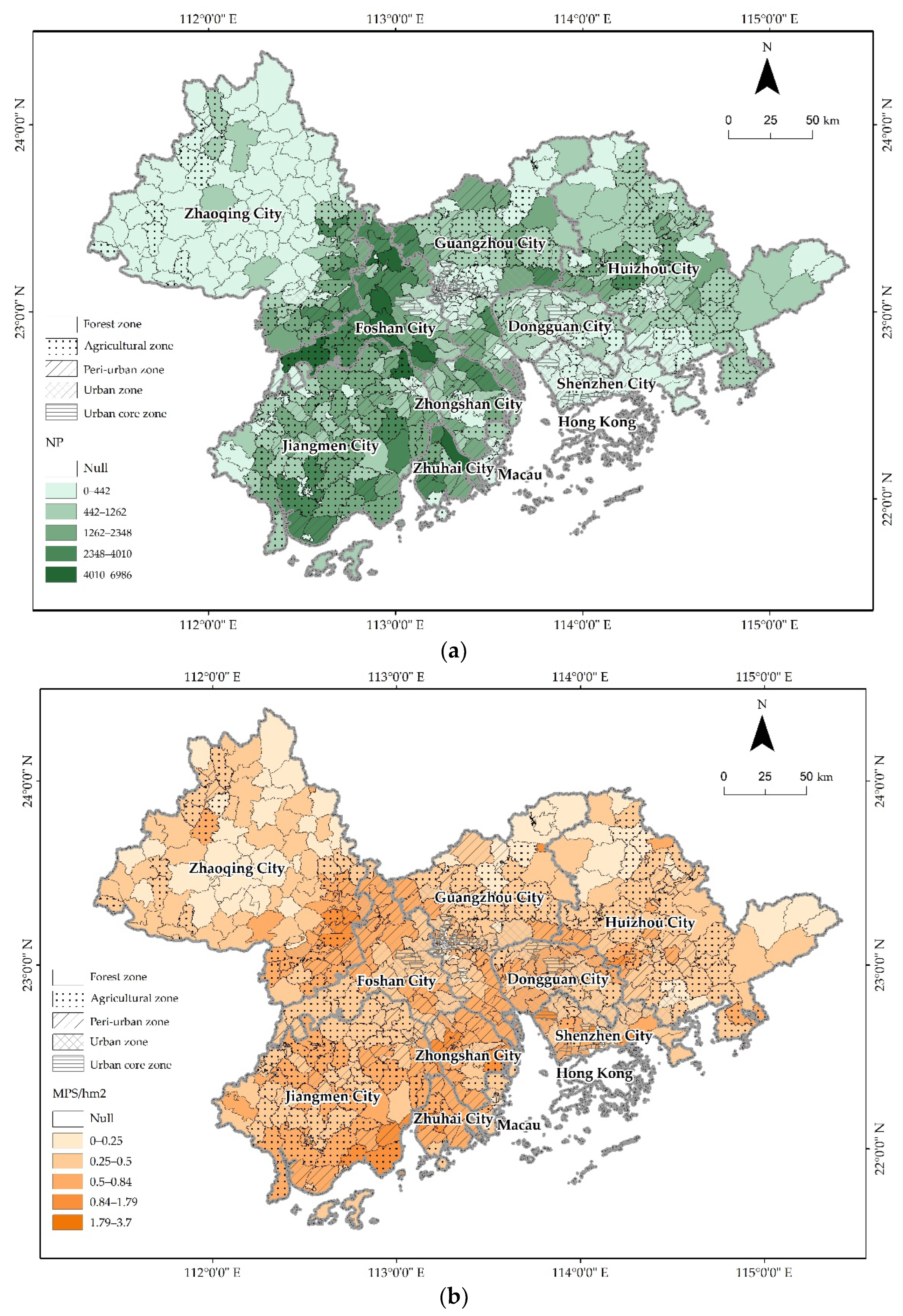
3.3. Spatial Differentiation of Pond Landscapes across the Urban-Rural Gradient in the PRD with Towns as Units
4. Discussion
4.1. Influence of Natural Environment and Human Activities on Spatial Differentiation in Pond Landscapes across an Urban-Rural Gradient
4.2. Influence of Urban-Rural Gradient Landscape Heterogeneity on Pond Conservation and Management
4.3. Mapping of Ponds in the PRD and Future Directions
5. Conclusions
Author Contributions
Funding
Institutional Review Board Statement
Informed Consent Statement
Data Availability Statement
Acknowledgments
Conflicts of Interest
References
- Biggs, J.; von Fumetti, S.; Kelly-Quinn, M. The importance of small waterbodies for biodiversity and ecosystem services: Implications for policy makers. Hydrobiologia 2017, 793, 3–39. [Google Scholar] [CrossRef]
- Hill, M.J.; Greaves, H.M.; Sayer, C.D.; Hassall, C.; Milin, M.; Milner, V.S.; Marazzi, L.; Hall, R.; Harper, L.R.; Thornhill, I.; et al. Pond ecology and conservation: Research priorities and knowledge gaps. Ecosphere 2021, 12, e03853. [Google Scholar] [CrossRef]
- Edwards, P. Aquaculture environment interactions: Past, present and likely future trends. Aquaculture 2015, 447, 2–14. [Google Scholar] [CrossRef]
- Cheng, F.Y.; Basu, N.B. Biogeochemical hotspots: Role of small water bodies in landscape nutrient processing. Water Resour. Res. 2017, 53, 5038–5056. [Google Scholar] [CrossRef]
- Gilbert, P.J.; Cooke, D.A.; Deary, M.; Taylor, S.; Jeffries, M.J. Quantifying rapid spatial and temporal variations of CO2 fluxes from small, lowland freshwater ponds. Hydrobiologia 2017, 793, 83–93. [Google Scholar] [CrossRef]
- Holgerson, M.A.; Raymond, P.A. Large contribution to inland water CO2 and CH4 emissions from very small ponds. Nat. Geosci. 2016, 9, 222–226. [Google Scholar] [CrossRef]
- Ruggiero, A.; Cereghino, R.; Figuerola, J.; Marty, P.; Angelibert, S. Farm ponds make a contribution to the biodiversity of aquatic insects in a French agricultural landscape. Comptes Rendus Biol. 2008, 331, 298–308. [Google Scholar] [CrossRef]
- Casanova, M.T.; DouglasHill, A.; Brock, M.A.; Muschal, M.; Bales, M. Farm ponds in New South Wales, Australia: Relationship between macrophyte and phytoplankton abundances. Mar. Freshw. Res. 1997, 48, 353–360. [Google Scholar] [CrossRef]
- Cereghino, R.; Ruggiero, A.; Marty, P.; Angelibert, S. Biodiversity and distribution patterns of freshwater invertebrates in farm ponds of a south-western French agricultural landscape. Hydrobiologia 2008, 597, 43–51. [Google Scholar] [CrossRef]
- Swartz, T.M.; Miller, J.R. Managing farm ponds as breeding sites for amphibians: Key trade-offs in agricultural function and habitat conservation. Ecol. Appl. 2019, 29, e01964. [Google Scholar] [CrossRef]
- Davies, S.R.; Sayer, C.D.; Greaves, H.; Siriwardena, G.M.; Axmacher, J.C. A new role for pond management in farmland bird conservation. Agric. Ecosyst. Environ. 2016, 233, 179–191. [Google Scholar] [CrossRef]
- Froneman, A.; Mangnall, M.J.; Little, R.M.; Crowe, T.M. Waterbird assemblages and associated habitat characteristics of farm ponds in the Western Cape, South Africa. Biodivers. Conserv. 2001, 10, 251–270. [Google Scholar] [CrossRef]
- Riley, W.D.; Potter, E.C.E.; Biggs, J.; Collins, A.L.; Jarvie, H.P.; Jones, J.I.; Kelly-Quinn, M.; Ormerod, S.J.; Sear, D.A.; Wilby, R.L.; et al. Small Water Bodies in Great Britain and Ireland: Ecosystem function, human-generated degradation, and options for restorative action. Sci. Total Environ. 2018, 645, 1598–1616. [Google Scholar] [CrossRef] [PubMed]
- Wisser, D.; Frolking, S.; Douglas, E.M.; Fekete, B.M.; Schumann, A.H.; Voeroesmarty, C.J. The significance of local water resources captured in small reservoirs for crop production—A global-scale analysis. J. Hydrol. 2010, 384, 264–275. [Google Scholar] [CrossRef]
- European Pond Conservtion Network. Available online: https://www.europeanponds.org/ (accessed on 25 December 2021).
- Chen, W.J.; He, B.; Nover, D.; Lu, H.M.; Liu, J.; Sun, W.; Chen, W. Farm ponds in southern China: Challenges and solutions for conserving a neglected wetland ecosystem. Sci. Total Environ. 2019, 659, 1322–1334. [Google Scholar] [CrossRef]
- Hill, M.J.; Hassall, C.; Oertli, B.; Fahrig, L.; Robson, B.J.; Biggs, J.; Samways, M.J.; Usio, N.; Takamura, N.; Krishnaswamy, J.; et al. New policy directions for global pond conservation. Conserv. Lett. 2018, 11, e12447. [Google Scholar] [CrossRef]
- Ouyang, X.; Lee, S.; Wang, W. The ‘Perfect’ Conversion: Dramatic Increase in CO2 Efflux from Shellfish Ponds and Mangrove Conversion in China. Sustainability 2021, 13, 13163. [Google Scholar] [CrossRef]
- Ren, C.; Wang, Z.; Zhang, Y.; Zhang, B.; Chen, L.; Xi, Y.; Xiao, X.; Doughty, R.B.; Liu, M.; Jia, M.; et al. Rapid expansion of coastal aquaculture ponds in China from Landsat observations during 1984–2016. Int. J. Appl. Earth Obs. Geoinf. 2019, 82, 101902. [Google Scholar] [CrossRef]
- Duan, Y.; Tian, B.; Li, X.; Liu, D.; Sengupta, D.; Wang, Y.; Peng, Y. Tracking changes in aquaculture ponds on the China coast using 30 years of Landsat images. Int. J. Appl. Earth Obs. Geoinf. 2021, 102, 102383. [Google Scholar] [CrossRef]
- Chen, W.; Li, T.; Zhang, L.; Zhang, H.; Yan, M.; Du, Y. Change monitoring of aquaculture ponds on the west bank of Ha Long Bay based on remote sensing technology and analysis of its impact on production-living-ecological land. Bull. Surv. Mapp. 2020, 9, 66–71. [Google Scholar]
- Duan, Y.; Li, X.; Zhang, L.; Liu, W.; Liu, S.a.; Chen, D.; Ji, H. Detecting spatiotemporal changes of large-scale aquaculture ponds regions over 1988-2018 in Jiangsu Province, China using Google Earth Engine. Ocean. Coast. Manag. 2020, 188, 105144. [Google Scholar] [CrossRef]
- Mao, D.; Wang, Z.; Wu, J.; Wu, B.; Zeng, Y.; Song, K.; Yi, K.; Luo, L. China’s wetlands loss to urban expansion. Land Degrad. Dev. 2018, 29, 2644–2657. [Google Scholar] [CrossRef]
- Boothby, J. Pond conservation: Towards a delineation of pondscape. Aquat. Conserv. Mar. Freshw. Ecosyst. 1997, 7, 127–132. [Google Scholar] [CrossRef]
- Fang, W.-T.; Chou, J.-Y.; Lu, S.-Y. Simple Patchy-Based Simulators Used to Explore Pondscape Systematic Dynamics. PLoS ONE 2014, 9, e86888. [Google Scholar] [CrossRef] [PubMed]
- Huang, S.-L.; Lee, Y.-C.; Budd, W.W.; Yang, M.-C. Analysis of Changes in Farm Pond Network Connectivity in the Peri-Urban Landscape of the Taoyuan Area, Taiwan. Environ. Manag. 2012, 49, 915–928. [Google Scholar] [CrossRef] [PubMed]
- Wang, Z.; Zhu, G. A Study on Characteristic Changes and Causes of Pond Landscape Systems in the Process of Urbanization. Acta Sci. Nat. Univ. Pekin. 2017, 53, 701–709. [Google Scholar] [CrossRef]
- Burgin, S.; Franklin, M.J.M.; Hull, L. Wetland Loss in the Transition to Urbanisation: A Case Study from Western Sydney, Australia. Wetlands 2016, 36, 985–994. [Google Scholar] [CrossRef]
- Lo, C.P. Environmental impact on the development of agricultural technology in China: The case of the dike-pond (‘jitang’) system of integrated agriculture-aquaculture in the Zhujiang Delta of China. Agric. Ecosyst. Environ. 1996, 60, 183–195. [Google Scholar] [CrossRef]
- Wang, X.; Yan, F.; Zeng, Y.; Chen, M.; Su, F.; Cui, Y. Changes in Ecosystems and Ecosystem Services in the Guangdong-Hong Kong-Macao Greater Bay Area since the Reform and Opening Up in China. Remote Sens. 2021, 13, 1611. [Google Scholar] [CrossRef]
- Li, F.; Liu, K.; Tang, H.; Liu, L.; Liu, H. Analyzing Trends of Dike-Ponds between 1978 and 2016 Using Multi-Source Remote Sensing Images in Shunde District of South China. Sustainability 2018, 10, 3504. [Google Scholar] [CrossRef]
- Liu, K.; Wang, S.; Xie, L.; Zhuang, J. Spatial Evolution Analysis of Dike-Pond Systems in Foshan City. Trop. Geogr. 2008, 28, 513–517. [Google Scholar] [CrossRef]
- Ye, C. Change Characteristics and Spatial Types of Dike-pond in the Pearl River Delta. J. East China Inst. Technol. 2013, 36, 315–322. [Google Scholar] [CrossRef]
- Lin, M.; Feng, R.; Ji, S. Analysis on mode change and landscape pattern of the Dike-pond agriculture in Zhongshan. Guangdong Agric. Sci. 2014, 41, 184–197. [Google Scholar] [CrossRef]
- Xiao, W.; Gong, J.; Wei, X. Spatio-temporal change and its driving factors of dike-pond landscape in Zhongshan, 1980–2015. Ecol. Sci. 2019, 38, 64–73. [Google Scholar] [CrossRef]
- Guo, Y.; Liu, Y.; Oerlemans, A.; Lao, S.; Wu, S.; Lew, M.S. Deep learning for visual understanding: A review. Neurocomputing 2016, 187, 27–48. [Google Scholar] [CrossRef]
- Kamilaris, A.; Prenafeta-Boldu, F.X. Deep learning in agriculture: A survey. Comput. Electron. Agric. 2018, 147, 70–90. [Google Scholar] [CrossRef]
- Zhao, Z.-Q.; Zheng, P.; Xu, S.-T.; Wu, X. Object Detection With Deep Learning: A Review. IEEE Trans. Neural Netw. Learn. Syst. 2019, 30, 3212–3232. [Google Scholar] [CrossRef]
- Province, S.B.O.G. Statistical Yearbook of Guangdong Province 2021; China Statistic Press: Beijing, China, 2021. [Google Scholar]
- Hu, P.; Li, F.; Hu, D.; Sun, Y.; Chen, X. Spatial and temporal characteristics of urban expansion in Pearl River Delta urban agglomeration from 1980 to 2015. Acta Ecol. Sin. 2021, 41, 7063–7072. [Google Scholar] [CrossRef]
- Xu, Z. The River System Landscape and Structural Problems of the Pearl River Delta. Chin. Landsc. Archit. 2009, 25, 54–58. [Google Scholar] [CrossRef]
- Committee, F.R. The Pearl River Delta Agricultural Records (Preliminary Draft); The Writing Group of The Pearl River Delta Agricultural Records of Foshan Revolutionary Committee: Foshan, China, 1976. [Google Scholar]
- Kenneth Ruddle, G.Z. Integrated Agriculture-Aquaculture in South China: The Dike-Pond System of the Zhujiang Delta; Cambridge University Press: Cambridge, MA, USA, 1987. [Google Scholar]
- Ottinger, M.; Clauss, K.; Kuenzer, C. Large-Scale Assessment of Coastal Aquaculture Ponds with Sentinel-1 Time Series Data. Remote Sens. 2017, 9, 440. [Google Scholar] [CrossRef]
- Kaminski, A.; Bauer, D.M.; Bell, K.P.; Loftin, C.S.; Nelson, E.J. Using landscape metrics to characterize towns along an urban-rural gradient. Landsc. Ecol. 2021, 36, 2937–2956. [Google Scholar] [CrossRef]
- Cai, Z.; Fang, C.; He, Q.; Yan, J.; Gao, D.; Liu, Z. Urban-rural Gradient Identification and Ecosystem Service Response in the Main Urban Area of anchang Based on Landscape Clustering. Res. Environ. Sci. 2021, 35, 806–817. [Google Scholar] [CrossRef]
- Vogt, P.; Riitters, K. GuidosToolbox: Universal digital image object analysis. Eur. J. Remote Sens. 2017, 50, 352–361. [Google Scholar] [CrossRef]
- Wu, J. Landscape Ecology: Pattern, Process, Scale and Hierarchy; Higher Education Press: Beijing, China, 2007. [Google Scholar]
- Li, Y.; You, L.; Chen, Y.; Huang, J. Spatial-temporal characteristics of multi-pond landscape change and their driving factors in the Chaohu Basin, China. Acta Ecol. Sin. 2018, 38, 6280–6291. [Google Scholar] [CrossRef][Green Version]
- Liu, X.; Chen, J.; Wang, J. Variations and Influencing Factors of Urban Ponds in Guangzhou’s Rapid Urbanization Zone. Urban Insight 2017, 49, 50–60. [Google Scholar] [CrossRef]
- Jiang, P.; Chen, D.; Li, M. Farmland landscape fragmentation evolution and its driving mechanism from rural to urban: A case study of Changzhou City. J. Rural. Stud. 2021, 82, 1–18. [Google Scholar] [CrossRef]
- Liu, J.; Hull, V.; Carter, N.; Viña, A.; Yang, W. Framing sustainability of coupled human and natural systems. In Pandas and People: Coupling Human and Natural Systems for Sustainability; Oxford University Press: Oxford, UK, 2016; Volume 33. [Google Scholar] [CrossRef]
- Liu, J.; Dietz, T.; Carpenter, S.; Alberti, M.; Folke, C.; Moran, E.; Pell, A.; Deadman, P.; Kratz, T.; Lubchenco, J.; et al. Complexity of Coupled Human and Natural Systems. Science 2007, 317, 6. [Google Scholar] [CrossRef]
- Li, L.; Lei, G.; Lin, M.; Li, J. Development Status and Countermeasures of Extension Agriculture in Shunde District, Foshan City. S. China Rural. Area 2012, 28, 22–30. [Google Scholar] [CrossRef]
- Boothby, J. Framing a strategy for pond landscape conservation: Aims, objectives and issues. Landsc. Res. 1999, 24, 67–83. [Google Scholar] [CrossRef]
- Knapp, S.; Schmauck, S.; Zehnsdorf, A. Biodiversity Impact of Green Roofs and Constructed Wetlands as Progressive Eco-Technologies in Urban Areas. Sustainability 2019, 11, 5846. [Google Scholar] [CrossRef]
- Chou, R.J.; Wu, C.T.; Huang, F.T. Fostering Multi-Functional Urban Agriculture: Experiences from the Champions in a Revitalized Farm Pond Community in Taoyuan, Taiwan. Sustainability 2017, 9, 2097. [Google Scholar] [CrossRef]
- Han, X.; Yu, K.; Li, D.; Wang, S. Building the Landscape Security Pattern Of Dike-Pond System With Urban Functions—A Case of Magang Part of Shunde District, Foshan City. Areal Res. Dev. 2008, 27, 107–110. [Google Scholar] [CrossRef]
- Swartz, T.M.; Miller, J.R. The American Pond Belt: An untold story of conservation challenges and opportunities. Front. Ecol. Environ. 2021, 19, 501–509. [Google Scholar] [CrossRef]
- Ottinger, M.; Bachofer, F.; Huth, J.; Kuenzer, C. Mapping Aquaculture Ponds for the Coastal Zone of Asia with Sentinel-1 and Sentinel-2 Time Series. Remote Sens. 2022, 14, 153. [Google Scholar] [CrossRef]
- Van Meter, K.J.; Basu, N.B. Signatures of human impact: Size distributions and spatial organization of wetlands in the Prairie Pothole landscape. Ecol. Appl. 2015, 25, 451–465. [Google Scholar] [CrossRef]

| Evaluation Metrics | Definition | Formula |
|---|---|---|
| Acc | Accuracy of ponds or background | |
| mAcc | Average accuracy of both classes (ponds and background) | |
| IoU | The ratio of the intersection and the union of ponds or background | |
| mIoU | The average IoU for both classes (ponds and background) |
| Class | Acc (%) | IoU (%) |
|---|---|---|
| Ponds | 92.64 | 89.02 |
| Background | 99.57 | 92.64 |
| mAcc (%) | mIoU (%) |
|---|---|
| 96.11 | 93.92 |
| CA (hm2) | Number of Towns in Urban Core Zone | Number of Towns in Urban Zone | Number of Towns in Peri-Urban Zone | Number of Towns in Agricultural Zone | Number of Towns in Forest Zone |
|---|---|---|---|---|---|
| 2399–4177 | 0 | 0 | 11 | 0 | 0 |
| 1412–2399 | 0 | 0 | 25 | 10 | 0 |
| 736–1412 | 0 | 2 | 27 | 26 | 1 |
| 240–736 | 0 | 15 | 46 | 52 | 10 |
| <240 | 100 | 101 | 47 | 56 | 136 |
Publisher’s Note: MDPI stays neutral with regard to jurisdictional claims in published maps and institutional affiliations. |
© 2022 by the authors. Licensee MDPI, Basel, Switzerland. This article is an open access article distributed under the terms and conditions of the Creative Commons Attribution (CC BY) license (https://creativecommons.org/licenses/by/4.0/).
Share and Cite
Chen, C.; Jiang, H.; Liu, X.; Huang, G.; Lai, Y.; Jing, W. Spatial Differentiation of Pond Landscapes across an Urban-Rural Gradient in the Pearl River Delta Region. Water 2022, 14, 1637. https://doi.org/10.3390/w14101637
Chen C, Jiang H, Liu X, Huang G, Lai Y, Jing W. Spatial Differentiation of Pond Landscapes across an Urban-Rural Gradient in the Pearl River Delta Region. Water. 2022; 14(10):1637. https://doi.org/10.3390/w14101637
Chicago/Turabian StyleChen, Caixia, Hao Jiang, Xulong Liu, Guangqing Huang, Yong Lai, and Wenlong Jing. 2022. "Spatial Differentiation of Pond Landscapes across an Urban-Rural Gradient in the Pearl River Delta Region" Water 14, no. 10: 1637. https://doi.org/10.3390/w14101637
APA StyleChen, C., Jiang, H., Liu, X., Huang, G., Lai, Y., & Jing, W. (2022). Spatial Differentiation of Pond Landscapes across an Urban-Rural Gradient in the Pearl River Delta Region. Water, 14(10), 1637. https://doi.org/10.3390/w14101637


