
Monitoring and Analysis of Water Level Changes in Mekong River from ICESat-2 Spaceborne Laser Altimetry


Abstract
:1. Introduction
2. Materials and Methods
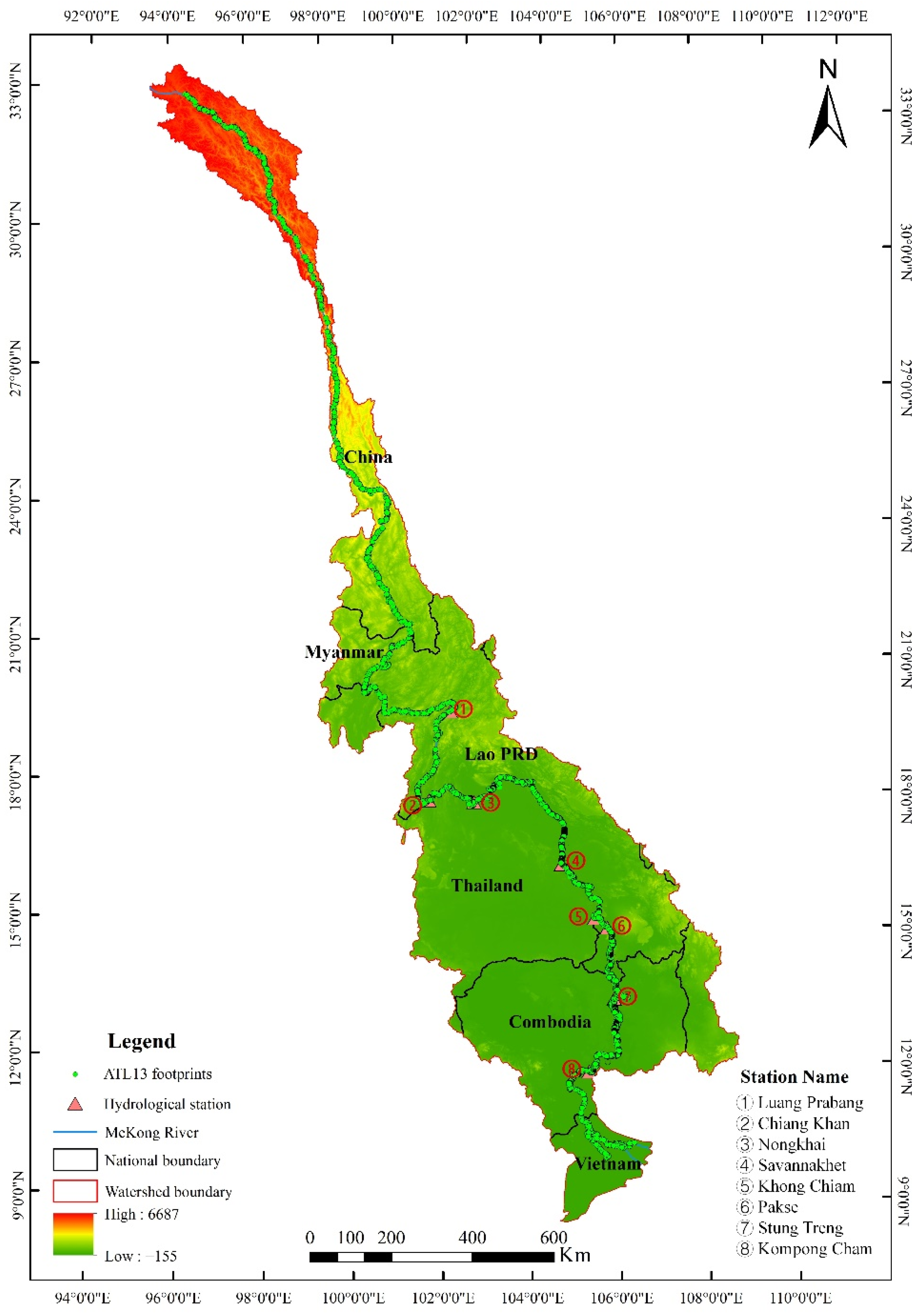
2.1. Study Area
2.2. ICESat-2 Altimetry Data
2.3. Remote Sensing Data
- (1)
- Landsat Images. The present study used Landsat OLI images with 30 m spatial resolution (image set No.: Landsat/lt05/C01/t1_sr) to map the boundary of the Mekong River via the Google Earth Engine (GEE) platform (https://code.earthengine.google.com (accessed on 5 November 2021)). The timeseries of images were selected over the dry season (November 2019 to April 2020) corresponding with the period of the minimum river boundary, thereby ensuring that photons falling on the river surface were picked out to represent river water level.
- (2)
- DEM data. The Shuttle Radar Topography Mission (SRTM) DEM data with 30 m spatial resolution (data number: USGS/SRTMGL1_003) on the GEE platform were used to remove false water surfaces, such as mountains shadows, and to enhance extraction precision of the water surface. The data were updated in February 2000.
2.4. In Situ Water Level of Hydrological Station
3. Methods
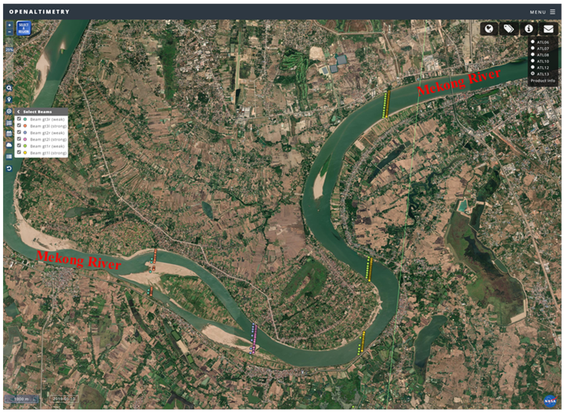
3.1. Extraction of the River Boundary
3.2. Extraction of ICESat-2 Water Level
- (1)
- Data filtering. The theory behind the ATL13 algorithm [43] indicated that the “qf_bckgrd”, “qf_bias_em”, “qf_bias_fit”, and “stdev_water_surf” quality flags can be directly utilized to filter out erroneous or low-quality observation values. The “qf_bckgrd” indicates the background rate of short segments, the “qf_bias_em” represents errors in calculated elevation due to a shift in slope and wavy surface, “qf_bias_fit” represents the height bias between the centroid elevations of the observed surface water histogram and the fitted integrated histogram, and “stdev_water_surf” represents the standard deviation of the water surface. The following combinations of flags indicates invalid data [28]: (1) “qf_bckgrd” = 6; (2) “qf_bias_em” ≥ 3 or “qf_bias_em” = −3; (3) “qf_bias_fit” ≥ 3 or “qf_bias_fit” = −3; (4) “stdev_water_surf” > 2.
- (2)
- Extraction of water level from ATL13 data. After data filtering, the river boundary was used to select the photons falling on the river surface. The orthometric heights EMG2008 and significant wave heights were then derived. The instantaneous water level was calculated by the orthometric height EMG2008 minus the significant wave height.
- (3)
- Outlier removal. Outliers in the river surface remained evident after data filtering. Therefore, 2-sigma criteria were adopted to remove the outliers of each ground track for each observation time. Finally, the remaining observations were used to calculate the average water levels for each observation time.
3.3. Uncertainty Estimation and Accuracy Validation
- (1)
- Estimation of uncertainty in ICESat-2 water level
- (2)
- Validation of measurement precision of ICESat-2 water level
4. Results and Discussion
4.1. Performance of ICESat-2 ATL13 Data
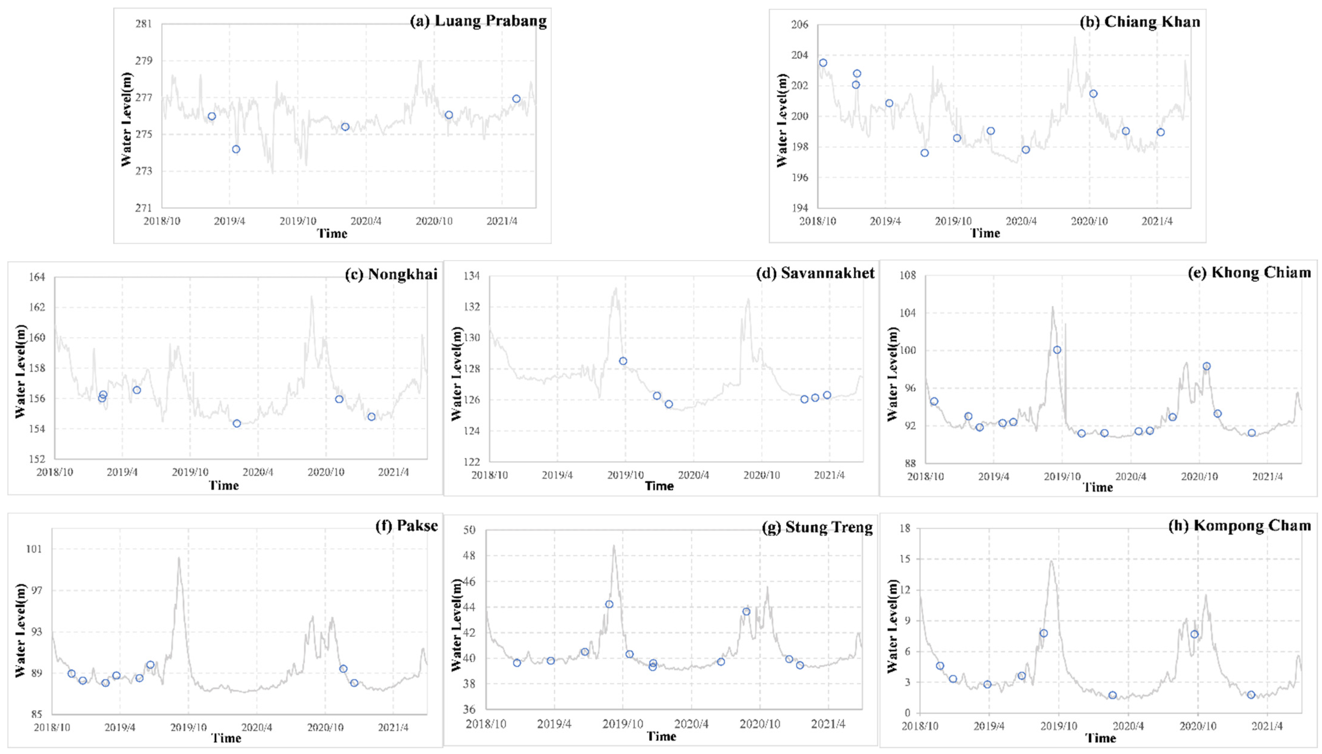
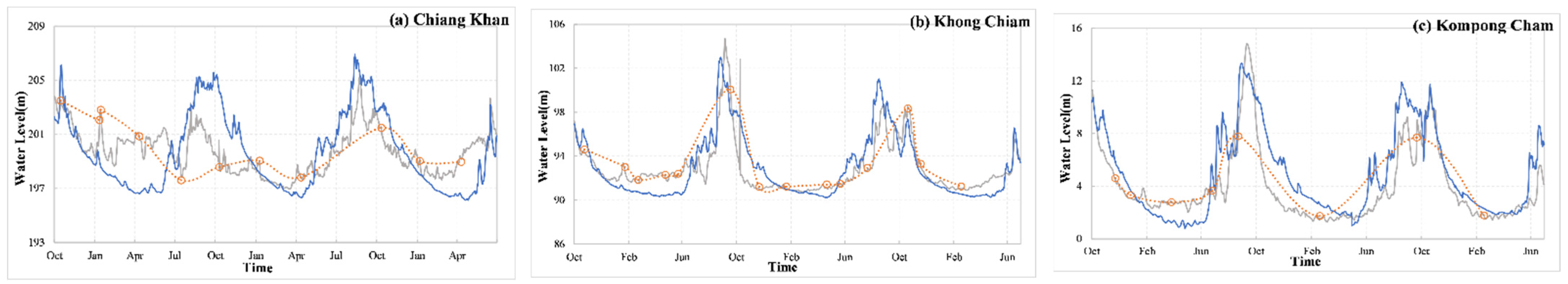
4.2. Analysis of Changes in Water Level
4.3. Comparison of Precision of Water Level Measurements with Those of Previous Studies
5. Conclusions
- (1)
- Remote-sensed water level data extracted from ICESat-2 laser altimetry data showed a high accuracy and a low measurement uncertainty when compared to in situ data, with an MSD, bias, and RMSE of 0.04, −0.05 m, and 0.19 m, respectively. Therefore, these remote-sensed water level data can be applied to supplement in situ water level for areas lacking observation records.
- (2)
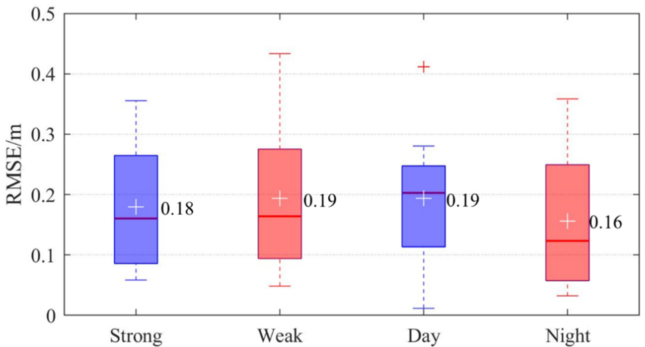
- Although all the ICESat-2 water level data could be applied for water level monitoring, the measurement precision of data under different acquisition conditions showed that there was not a clear difference between measurement precision of strong beam data and weak beam data (difference in RMSE of 0.01 m), whereas nighttime measurements were more accurate than daytime measurements (RMSEs of 0.16 m and 0.19 m, respectively).
- (3)
- The variation in water level among different stations along the Mekong River from 2018 to 2021 showed that variations in water level due to natural factors were similar between the upstream and downstream of Mekong River, although there were also intra-annual and inter-annual changes. An analysis of changes in water levels between two periods representative of before and after hydropower development showed that hydropower development generally decreased the range of water level during the flooding season and increased the water level during the dry season. These changes were conducive to the regulation of water resources.
Author Contributions
Funding
Institutional Review Board Statement
Informed Consent Statement
Data Availability Statement
Acknowledgments
Conflicts of Interest
References
- Pekel, J.F.; Cottam, A.; Gorelick, N.; Belward, A.S. High-resolution mapping of global surface water and its long-term changes. Nature 2016, 540, 418–422. [Google Scholar] [CrossRef] [PubMed]
- Guo, H.D. Big Earth Data in Support of the Sustainable Development Goals (2020): The Belt and Road; Science Press: Beijing, China, 2021. [Google Scholar]
- World Economic Forum. Global Risks 2015; Davos-Klosters: Geneva, Switzerland, 2015. [Google Scholar]
- Durand, M.; Gleason, C.J.; Garambois, P.A.; Bjerklie, D.; Smith, L.C.; Roux, H.; Rodriguez, E.; Bates, P.D.; Pavelsky, T.M.; Monnier, J.; et al. An intercomparison of remote sensing river discharge estimation algorithms from measurements of river height, width, and slope. Water Resour. Res. 2016, 52, 4527–4549. [Google Scholar] [CrossRef] [Green Version]
- Thilakarathne, M.; Sridhar, V. Characterization of future drought conditions in the Lower Mekong River basin. Weather Clim. Extrem. 2017, 17, 47–58. [Google Scholar] [CrossRef]
- Yun, X.B.; Tang, Q.H.; Wang, J.; Liu, X.C.; Zhang, Y.Q.; Lu, H.; Wang, Y.L.; Zhang, L.; Chen, D.L. Impacts of climate change and reservoir operation on streamflow and flood characteristics in the Lancang-Mekong River Basin. J. Hydrol. 2020, 590, 125472. [Google Scholar] [CrossRef]
- Yun, X.B.; Tang, Q.H.; Li, J.B.; Lu, H.; Zhang, L.; Chen, D.L. Can reservoir regulation mitigate future climate change induced hydrological extremes in the Lancang-Mekong River Basin? Sci. Total Environ. 2021, 785, 147322. [Google Scholar] [CrossRef]
- He, D.M.; Liu, C.M.; Feng, Y.; Hu, J.M.; Ji, X.; Li, Y.G. Progress and perspective of international river researches in China. Acta Geogr. Sin. 2014, 69, 1284–1294. (In Chinese) [Google Scholar]
- Yu, Y.; Zhao, J.S.; Li, D.; Wang, Z.J. Effects of Hydrologic Conditions and Reservoir Operation on Transboundary Cooperation in the Lancang–Mekong River Basin. J. Water Resour. Plan. Manag. 2019, 145, 04019020. [Google Scholar] [CrossRef]
- Xu, H.; Song, Y.P.; Goldsmith, Y.; Lang, Y.C. Meridional ITCZ shifts modulate tropical/subtropical Asian monsoon rainfall. Sci. Bull. 2019, 64, 1737–1739. [Google Scholar] [CrossRef] [Green Version]
- Sulistioadi, Y.B.; Tseng, K.-H.; Shum, C.K.; Hidayat, H.; Sumaryono, M.; Suhardiman, A.; Setiawan, F.; Sunarso, S. Satellite radar altimetry for monitoring small rivers and lakes in Indonesia. Hydrol. Earth Syst. Sci. 2015, 19, 341–359. [Google Scholar] [CrossRef] [Green Version]
- He, D.M.; Liu, H.; Feng, Y.; Ni, G.H.; Kong, L.J.; Long, A.H.; Zhang, C.C. Perspective on theories and methods study of transboundary water resources under the global change. Adv. Water Sci. 2016, 27, 928–934. (in Chinese) [Google Scholar] [CrossRef]
- Liu, K.-T.; Tseng, K.-H.; Shum, C.K.; Liu, C.-Y.; Kuo, C.-Y.; Liu, G.M.; Jia, Y.Y.; Shang, K. Assessment of the impact of reservoirs in the upper Mekong River using satellite radar altimetry and remote sensing imageries. Remote Sens. 2016, 8, 367. [Google Scholar] [CrossRef] [Green Version]
- Seyler, F.; Calmant, S.; Silva, J.S.D.; Moreira, D.M.; Mercier, F.; Shum, C.K. From TOPEX/Poseidon to Jason-2/OSTM in the Amazon basin. Adv. Space Res. 2013, 51, 1542–1550. [Google Scholar] [CrossRef]
- Silva, S.D.J.; Calmant, S.; Seyler, F.; Filho, O.C.R.; Cochonneau, G.; Mansur, W.J. Water levels in the Amazon basin derived from the ERS 2 and ENVISA T radar altimetry missions. Remote Sens. Environ. 2010, 114, 2160–2181. [Google Scholar] [CrossRef]
- Tourian, M.J.; Tarpanelli, A.; Elmi, O.; Qin, T.; Brocca, L.; Moramarco, T.; Sneeuw, N. Spatiotemporal densification of river water level time series by multimission satellite altimetry. Water Resour. Res. 2016, 52, 1140–1159. [Google Scholar] [CrossRef] [Green Version]
- Huang, Q.; Li, X.D.; Han, P.F.; Long, D.; Zhao, F.Y.; Hou, A.Z. Validation and application of water levels derived from Sentinel-3A for the Brahmaputra River. Sci. China Technol. Sci. 2019, 62, 1760–1772. [Google Scholar] [CrossRef]
- Shu, S.; Liu, H.X.; Beck, R.A.; Frappart, F.; Korhonen, J.; Xu, M.; Yang, B.; Hinkel, K.M.; Huang, Y.; Yu, B.L. Analysis of Sentinel-3 SAR altimetry waveform retracking algorithms for deriving temporally consistent water levels over ice-covered lakes. Remote Sens. Environ. 2020, 239, 111643. [Google Scholar] [CrossRef]
- Jiang, L.G.; Andersen, O.B.; Nielsen, K.; Zhang, G.Q.; Bauer-Gottwein, P. Influence of local geoid variation on water surface elevation estimates derived from multimission altimetry for Lake Namco. Remote Sens. Environ. 2019, 221, 65–79. [Google Scholar] [CrossRef]
- Villadsen, H.; Andersen, O.B.; Stenseng, L.; Nielsen, K.; Knudsen, P. CryoSat-2 altimetry for river level monitoring-Evaluation in the Ganges-Brahmaputra River basin. Remote Sens. Environ. 2015, 168, 80–89. [Google Scholar] [CrossRef]
- Michailovsky, C.I.; McEnnis, S.; Berry, P.A.M.; Smith, R.; Bauer-Gottwein, P. River monitoring from satellite radar altimetry in the Zambezi River basin. Hydrol. Earth Syst. Sci. 2012, 16, 2181–2192. [Google Scholar] [CrossRef] [Green Version]
- Scharroo, R.; Bonekamp, H.; Ponsard, C.; Parisot, F.; von Engeln, A.; Tahtadjiev, M.; Vriendt, K.; Montagner, F. Jason continuity of services: Continuing the Jason altimeter data records as Copernicus Sentinel-6. Ocean Sci. 2016, 12, 471–479. [Google Scholar] [CrossRef] [Green Version]
- Shi, L.W.; Xu, K.; Liu, P.; Yang, S.B.; Wang, L.; Yu, X.F. Height Precision of SAR Altimeter and Conventional Radar Altimeter Based on Flight Experimental Data. IEEE J. Sel. Top. Appl. Earth Obs. Remote Sens. 2016, 9, 2676–2686. [Google Scholar] [CrossRef]
- Song, C.Q.; Ye, Q.H.; Cheng, X. Shifts in water-level variation of Namco in the central Tibetan Plateau from ICESat and CryoSat-2 altimery and station observations. Sci. Bull. 2015, 60, 1287–1297. [Google Scholar] [CrossRef] [Green Version]
- Wang, X.W.; Gong, P.; Zhao, Y.Y.; Xu, Y.; Cheng, X.; Niu, Z.G.; Luo, Z.C.; Huang, H.B.; Sun, F.D.; Li, X.W. Water-level changes in China’s large lakes determined from ICESat/GLAS data. Remote Sens. Environ. 2013, 132, 131–144. [Google Scholar] [CrossRef]
- Ryan, J.C.; Smith, L.C.; Cooley, S.W.; Pitcher, L.H.; Pavelsky, T.M. Global characterization of inland water reservoirs using ICESat-2 altimetry and climate reanalysis. Geophys. Res. Lett. 2020, 47, e2020GL088543. [Google Scholar] [CrossRef]
- Xiang, J.; Li, H.; Zhao, J.Y.; Cai, X.B.; Li, P. Inland water level measurement from spaceborne laser altimetry: Validation and comparison of three missions over the Great Lakes and lower Mississippi River. J. Hydrol. 2021, 597, 126312. [Google Scholar] [CrossRef]
- Xu, N.; Zheng, H.Y.; Ma, Y.; Yang, J.; Li, X.Y.; Wang, X.H. Global estimation and assessment of monthly lake/reservoir water level changes using ICESat-2 ATL13 Products. Remote Sens. 2021, 13, 2744. [Google Scholar] [CrossRef]
- Abshire, J.B.; Sun, X.L.; Riris, H.; Sirota, J.M.; McGarry, J.F.; Palm, S.; Yi, D.H.; Liiva, P. Geoscience Laser Altimeter System (GLAS) on the ICESat Mission: On-orbit measurement performance. Geophys. Res. Lett. 2005, 32, L21S02. [Google Scholar] [CrossRef] [Green Version]
- Baghdadi, N.; Lemarquand, N.; Abdallah, H.; Bailly, J.S. The relevance of GLAS/ICESat elevation data for the monitoring of river networks. Remote Sens. 2011, 3, 708–720. [Google Scholar] [CrossRef] [Green Version]
- Yang, J.; Ethan Yang, Y.C.; Chang, J.X.; Zhang, J.R.; Yao, J. Impact of dam development and climate change on hydroecological conditions and natural hazard risk in the Mekong River Basin. J. Hydrol. 2019, 579, 124177. [Google Scholar] [CrossRef]
- Wang, S.X.; Zhang, L.P.; Li, Y.; She, D.X. Extreme flood in the Lancang River basin under climate change. Clim. Change Res. 2019, 15, 23–32. (In Chinese) [Google Scholar]
- Hoang, L.P.; Lauri, H.; Kummu, M.; Kopomen, J.; van Vliet, M.T.H.; Supit, I.; Leemans, R.; Kabat, P.; Ludwig, F. Mekong River flow and hydrological extremes under climate change. Hydrol. Earth Syst. Sci. 2016, 20, 3027–3041. [Google Scholar] [CrossRef] [Green Version]
- Tang, Q.H.; Liu, X.C.; Zhou, Y.Y.; Wang, J.; Yun, X.B. Cascading impacts of Asian water tower change on downstream water systems. Bull. Chin. Acad. Sci. 2019, 34, 1306–1312. (In Chinese) [Google Scholar]
- Zhu, X.X.; Nie, S.; Wang, C.; Xi, X.H.; Wang, J.S.; Li, D.; Zhou, H.Y. A noise removal algorithm based on OPTICS for photon-counting LiDAR data. IEEE Geosci. Remote Sens. Lett. 2021, 8, 1471–1475. [Google Scholar] [CrossRef]
- Nie, S.; Wang, C.; Xi, X.H.; Luo, S.Z.; Li, G.Y.; Tian, J.Y.; Wang, H.T. Estimating the vegetation canopy height using micro-pulse photon-counting LiDAR data. Opt. Express 2018, 26, A520–A540. [Google Scholar] [CrossRef]
- Neuenschwander, A.; Pitts, K. The ATL08 land and vegetation product for the ICESat-2 Mission. Remote Sens. Environ. 2019, 221, 247–259. [Google Scholar] [CrossRef]
- Lao, J.Y.; Wang, C.; Zhu, X.X.; Xi, X.H.; Nie, S.; Wang, J.L.; Cheng, F.; Zhou, G.Q. Retrieving building height in urban areas using ICESat-2 photon-counting LiDAR data. Int. J. Appl. Earth Obs. 2021, 104, 102596. [Google Scholar] [CrossRef]
- MRC (Mekong River Commission). Hydrometeorological Database of the Mekong River Commission; Mekong River Commission: Vientiane, Laos, 2011. [Google Scholar]
- Xu, H.Q. A study on information extraction of water body with the modified normalized difference water index (MNDWI). Natl. Remote Sen. Bull. 2005, 9, 589–595. (In Chinese) [Google Scholar]
- Otsu, N. Threshold selection method from gray-level histograms. IEEE Trans. Syst. Man Cybern. 1979, 9, 62–66. [Google Scholar] [CrossRef] [Green Version]
- Peng, Y.; He, G.J.; Wang, G.Z.; Yin, R.Y. Inland surface water products with 30m spatial resolution in Lanmei watershed. China Sci. Data 2020, 5, 97–105. (In Chinese) [Google Scholar]
- Jasinski, M.F.; Stoll, J.D.; Hancock, D.; Robbins, J.; Nattala, J.; Morison, J.; Jones, B.M.; Ondrusek, M.E.; Pavelsky, T.M.; Parrish, C.; et al. ATLAS/ICESat-2 L3A Inland Water Surface Height, Version 3; NASA National Snow and Ice Data Center Distributed Active Archive Center: Boulder, CO, USA, 2020. [Google Scholar]
- Yuan, C.; Gong, P.; Bai, Y.Q. Performance assessment of ICESat-2 laser altimeter data for Water-Level measurement over lakes and reservoirs in China. Remote Sens. 2020, 12, 770. [Google Scholar] [CrossRef] [Green Version]
- Urban, T.J.; Schutz, B.E.; Neuenschwander, A.L. A survey of ICESat coastal altimetry applications: Continental coast, open ocean island, and inland river. Terr. Atmos. Ocean. Sci. 2008, 19, 1–19. [Google Scholar] [CrossRef] [Green Version]
- Hall, A.C.; Schumann, G.J.-P.; Bamber, J.L.; Bates, P.D.; Trigg, M.A. Geodetic corrections to Amazon River water level gauges using ICESat altimetry. Water Resour. Res. 2012, 48, W06602. [Google Scholar] [CrossRef] [Green Version]
- Zakharova, E.; Nielsen, K.; Kamenev, G.; Kouraev, A. River discharge estimation from radar altimetry: Assessment of satellite performance, river scales and methods. J. Hydrol. 2020, 583, 124561. [Google Scholar] [CrossRef]
- Pham, H.T.; Marshall, L.; Johnson, F.; Sharma, A. Deriving daily water levels from satellite altimetry and land surface temperature for sparsely gauged catchments: A case study for the Mekong River. Remote Sens. Environ. 2018, 212, 31–46. [Google Scholar] [CrossRef]

| Location | Stations | River Width (m) | Num | Mean (m) | MSD (m) | Bias (m) | RMSE (m) |
|---|---|---|---|---|---|---|---|
| Upper Mekong | Luang Prabang | 450 | 9 | 276.04 | 0.06 | −0.28 | 0.30 |
| Chiang Khan | 600 | 23 | 201.14 | 0.03 | −0.02 | 0.05 | |
| Central Mekong | Nongkhai | 620 | 12 | 155.69 | 0.04 | 0.04 | 0.07 |
| Savannakhet | 760 | 11 | 127.03 | 0.03 | 0.23 | 0.25 | |
| Khong Chiam | 450 | 28 | 93.61 | 0.02 | −0.31 | 0.39 | |
| Pakse | 1400 | 16 | 88.69 | 0.03 | −0.12 | 0.18 | |
| Lower Mekong | Stung Treng | 1085 | 20 | 39.90 | 0.04 | 0.11 | 0.12 |
| Kompong Cham | 900 | 17 | 4.67 | 0.05 | −0.04 | 0.13 | |
| Mean of river | 0.04 | −0.05 | 0.19 | ||||
Publisher’s Note: MDPI stays neutral with regard to jurisdictional claims in published maps and institutional affiliations. |
© 2022 by the authors. Licensee MDPI, Basel, Switzerland. This article is an open access article distributed under the terms and conditions of the Creative Commons Attribution (CC BY) license (https://creativecommons.org/licenses/by/4.0/).
Share and Cite
Lao, J.; Wang, C.; Nie, S.; Xi, X.; Wang, J. Monitoring and Analysis of Water Level Changes in Mekong River from ICESat-2 Spaceborne Laser Altimetry. Water 2022, 14, 1613. https://doi.org/10.3390/w14101613
Lao J, Wang C, Nie S, Xi X, Wang J. Monitoring and Analysis of Water Level Changes in Mekong River from ICESat-2 Spaceborne Laser Altimetry. Water. 2022; 14(10):1613. https://doi.org/10.3390/w14101613
Chicago/Turabian StyleLao, Jieying, Cheng Wang, Sheng Nie, Xiaohuan Xi, and Jinliang Wang. 2022. "Monitoring and Analysis of Water Level Changes in Mekong River from ICESat-2 Spaceborne Laser Altimetry" Water 14, no. 10: 1613. https://doi.org/10.3390/w14101613
APA StyleLao, J., Wang, C., Nie, S., Xi, X., & Wang, J. (2022). Monitoring and Analysis of Water Level Changes in Mekong River from ICESat-2 Spaceborne Laser Altimetry. Water, 14(10), 1613. https://doi.org/10.3390/w14101613