Article

Uncertain Accelerated Sea-Level Rise, Potential Consequences, and Adaptive Strategies in The Netherlands

by
Jos van Alphen
1,*,
Marjolijn Haasnoot
2 and
Ferdinand Diermanse
2
1
Staff Delta Programme Commissioner, 2511 WB The Hague, The Netherlands
2
Deltares, 2600 MH Delft, The Netherlands
*
Author to whom correspondence should be addressed.
Water 2022, 14(10), 1527; https://doi.org/10.3390/w14101527
Submission received: 22 January 2022 / Revised: 20 April 2022 / Accepted: 6 May 2022 / Published: 10 May 2022

Abstract

:
Recent observations and publications have presented the possibility of a high and accelerated sea-level rise (SLR) later this century due to ice sheet instability and retreat in Antarctica. Under a high warming scenario, this may result in a sea level in 2100 that is up to 2 m higher than present and 5 m in 2150. The large uncertainties in these projections significantly increase the challenge for investment planning in coastal strategies in densely populated coastal zones such as the Netherlands. In this paper, we present the results of two studies that were carried out within the framework of the Dutch Delta Programme. The first study showed that it is not only the absolute SLR that presents a challenge but also the annual rate of rise. The latter impacts the lifetime of constructions such as barriers and pumping stations. When the rate of sea-level rise increases up to several centimeters per year, the intended lifetime of a flood defense structure may be reduced from a century to several decades. This new challenge requires new technologies, experiments, strategies, and governance. The second study explored different strategies for the long term to adapt to high SLR (>1 m) and assessed the consequences thereof on adaptation and developments in the coming 2–3 decades. We believe that strategic choices have to be made regarding the permanent closure of estuaries, the pumping or periodic storage of high river discharges, agriculture in an increasingly saline coastal area, and the maintenance of the coastline by beach nourishments. These strategic choices have to be complemented by no-regret measures such as spatial reservations for future sand extraction (for beach nourishments) and future expansion of flood defenses, water discharge, and water storage. In addition, it is advised to include flexibility in the design of new infrastructure.

1. Introduction

Coastal regions, especially deltas, have many benefits, such as supply of fresh water, sediments and nutrients from debouching rivers, wealthy and productive ecosystems that guarantee food by fisheries, aquaculture and agriculture, flat land to be developed, and access to international trade. Therefore, these areas attract people to live, work, and recreate, leading to continuous high investments in assets and infrastructure. As a result, coastal cities and communities are home to about 10% of the world’s population [1], especially in megacities such as Amsterdam, Buenos Aires, Hamburg, London, Miami, New York, Sydney, and Tokyo and rapidly expanding cities such as Bangkok, Dhaka, Ho Chi Minh City, Jakarta, Lagos, Manila, Mumbai, Shanghai, and Yangon. On the other hand, these areas are vulnerable to coastal erosion, floods and droughts, and pollution, and frequently suffer from related damage, casualties, and disruption.
Sea-level rise (SLR) is expected to impose large challenges to coastal zones. Without population change and additional adaptation, the population exposed to 100 yr coastal floods is projected to triple at 1.4 m SLR relative to the 2020 level. By 2100, the value of global assets within the 100 yr coastal floodplain is projected to vary between USD 7.9 and 14.2 trillion, depending on the emission scenario [2].
Between 1901 and 2018, the global mean sea level increased by 0.20 m. Between 1901 and 1971, the average rate of SLR was 1.3 mm/year, increasing to 1.9 mm/year between 1971 and 2006, and further increasing to 3.7 mm/year between 2006 and 2020 [3]. This SLR acceleration is human-made, and will probably continue this century [3]. Future climate change and SLR projections are driven by emissions and/or concentrations from illustrative Representative Concentration Pathways (RCPs) and Shared Socio-economic Pathways (SSPs) scenarios, respectively [2]. Depending on the greenhouse gas emission scenario, climate change may result in a SLR in 2100 (relative to 1995–2014) of 0.28–0.55 (assuming an extremely low emission scenario SSP1–1.9) to 0.98–1.88 m (assuming an extremely high emission scenario SSP5-8.5). Due to deep uncertainty in ice-sheet processes in Greenland and Antarctica, a SLR of 2 m in 2100 and 5 m in 2150 cannot be ruled out [3].
These large uncertainties in the projections significantly increase the challenge for investment planning in coastal management strategies in low-lying densely populated coastal zones such as the Netherlands. Planning and implementation of coastal defense projects may take many decades. E.g., after the 1953 storm, surge completion of the Delta-works dams, sluices, and storm surges barriers in the southwestern part of the Netherlands took 45 years. This long lead time for planning and implementation, as well as the large potential consequences of coastal flooding, makes it crucial to consider uncertain but possible high-end sea-level rise projections already for nearby investment decisions in water management and land use. To adapt to uncertain climate change, the Netherlands follows an adaptive approach with short-term actions and long-term options to be implemented depending on how the future unfolds [4].
This paper describes the approach of the Dutch government in dealing with projections of uncertain but potential accelerated SLR. We present the consequences regarding coastal management, flood protection, fresh water supply, and water drainage. The challenge of SLR may be dealt with by a wide variety of strategies, ranging from advancing seawards with a new higher coastal defense, maintaining and elevating the present coast, accommodation of water, and adapting land use to retreat from places at high risk [5]. This paper presents examples of these strategies that are being developed for the Netherlands. In this way, this paper illustrates the enormous potential impact of accelerating SLR on densely populated coastal areas. Hence, it also underlines the need to reduce greenhouse gas emissions in order to mitigate SLR and avoid these dramatic consequences. Moreover, it contributes to the debate on the urgency and strategies to adapt on SLR, as advocated in the recent IPCC WG2 report [2].

2. The Netherlands and the Delta Programme

The Netherlands is situated in the delta of the rivers Rhine, Meuse, Scheldt, and Ems along the North Sea coast. The coastal region consists of sandy beaches and dunes, estuaries, intertidal areas, and low-lying polders. These polders are densely populated, including the capital Amsterdam, government seat The Hague, and mainport Rotterdam. About 26% (10,500 km2) of the Netherlands’ territory is below mean sea level, and about 60% is vulnerable to floods from the North Sea, rivers, or lakes (Figure 1). This flood-prone area contains about 60% of the population of 17 million and produces about 60% of the gross domestic product (GDP) of about EUR 800 billion. Because of the large number of inhabitants and high value of assets, the Netherlands has a high level of flood protection, provided by a comprehensive system of dams, seawalls, storm surge barriers, dikes, dunes, pumps, sluices, and regular beach nourishments. Two major floods in 1916 and 1953 resulted in closing of the major tidal inlets and estuaries from the sea, which altogether shortened the original Dutch coastline of 1200 km to about 300 km. This flood protection and water management system is complemented by a well-developed governance system of district water boards, national agencies (Rijkswaterstaat), funding, legislation [6], and well-experienced knowledge institutes and private parties (e.g., dredgers). Maintenance and regular upgrading of this flood defense system to changing conditions costs about EUR 1.2 billion annually [7].
As a result of growing concern about the potential impact of climate change and SLR on the Dutch delta, in 2010, the government initiated the Delta Programme. The aim of the Delta Programme is to maintain the Dutch delta as an attractive place to live, work, and recreate for present and future generations [8]. The Delta Programme has a long-term time horizon, up to 2100. To make the inherent uncertainty in climate and socio-economic developments manageable, an adaptive approach has been adopted, including scenarios, adaptive strategies, and periodic (every 6 years) review [4]. A ‘Signal’ group of independent experts advises the Delta Commissioner on an annual basis on relevant new developments and knowledge that might influence the goals and implementation of the Delta Programme [9].
Figure 1. Flood-prone areas in the Netherlands, present situation. NAP is ordnance datum, which is about mean sea level. Dike rings are areas protected by flood defenses. (Reprinted with permission from Haasnoot et al., 2020 [10]).
Water 14 01527 g001
In 2014, the Delta Commissioner proposed strategies and measures to prepare for climate change, related to a 1.5 and 3.5 °C global warming scenario and anticipating a SLR of 0.3–1.0 m in 2100 (relative to 1990) [11]. This was in line with the most recent national climate change scenarios of the Royal Dutch Meteorological Institute [12]), which were based on 5th IPCC Assessment Report [13]. In 2017, the Signal group advised the Delta Commissioner to pay more attention to a possible acceleration of SLR and its potential consequences for the Dutch delta [14].
The Dutch delta is extremely vulnerable to SLR and an acceleration may have a major impact on the livability of the delta for future generations. This acceleration may unfold in the second half of this century, so present measures are sufficient until at least 2050. However, in SLR-related flood-prone areas, up to 2050, an estimated EUR 600 billion of investments is planned in urban developments, infrastructure, sustainable energy, and climate adaptation [15]. These types of investments predominantly involve projects with a lifetime of 50–100 years, which also determine future land use, and may trigger or block future adaptation options. Considering a potential acceleration of SLR within this lifetime, it becomes necessary to analyze whether these planned investments increase future risk, how this can be avoided, and which strategic choices have to be made. To answer these questions, in 2017, the Delta Commissioner initiated a study to assess the potential impact of accelerated SLR on the Dutch delta, followed in 2019 by an inventory of potential strategies and measures to deal with this accelerated SLR.

3. Materials and Methods

This paper describes the approach and main results of the SLR impact assessment on the Dutch delta and the inventory of potential strategies to deal with this threat.
Whether and how a natural delta adapts to SLR depends on the balance between the amount of sediment supplied to the delta by rivers, waves, and currents and the volume that is necessary for intertidal areas, riverbeds, and land to keep pace with SLR. Apart from the Wadden Sea, the Dutch delta is not natural anymore: rivers have been embanked and most floodplains have been turned into polder systems (and hence cut off from natural sediment supply), the coastline is artificially maintained with beach nourishments, the inlets and estuaries have been closed with dams or protected by storm surge barriers, and former lakes have been drained and turned into polders, with ground surface levels up to 6 m below the mean sea level. The impact of SLR on the Dutch delta is established on three essential elements of delta management: coastline maintenance, flood protection, and fresh water supply.
Our inventory was based on a scenario-neutral approach [16], based on [17], wherein we assessed the consequences conditional on the magnitude and rate of SLR (up to 3 m and 60 mm/year) on the present strategies. Scenarios could then be used to assess when this may occur. For example, in an RCP2.6 or RCP4.5 emission scenario, 1 m SLR may occur beyond or around 2100. In an RCP8.5 scenario, also including a contribution of melting Antarctic land ice, 1 m SLR may already be reached around 2070 and meet 1.95 m in 2100 [18].
The assessment of SLR consequences was primarily based on model computations and simulations, see [10] for more details. Necessary volumes of beach nourishments were estimated by using the area of the marine coastal zone (4000 km2) multiplied by different rates of SLR. Conceptual 0-dimensional water balance models were used to get a first impression of different combinations of storage and pumping capacities to manage river floods. Two-dimensional hydrodynamic model (WAQUA [19]) computations established hydraulic loads to assess related dike reinforcement efforts and storm surge barrier closure frequencies. Additionally, probabilistic model computations were carried out to assess impacts of sea-level rise on flood risks. The slow response of groundwater salinization to SLR was investigated by a regional 3D variable density groundwater flow model [20]. The results of this model provided input data for the National Water Model, a combination of groundwater, subsurface water, and surface water simulation models as well as water demand models to assess (fresh) water availability and demands in the Netherlands [21]. To estimate the effect of salinization on fresh water intake locations along the main rivers, a 3D hydraulic model supplied data on salt intrusion at values of 0, 2, and 4 m SLR.
These model computations provided an overview of critical consequences of SLR on our present water supply and flood management infrastructure (see Figure 2). For example, at 1 m SLR, the Eastern Scheldt storm surge barrier closure frequency may be increased from the current 1.5 to 45 times a year, if current closure criteria remain unchanged. This will have major consequences on the required maintenance effort, but also on the preservation of the intertidal habitats behind the barrier.
For the inventory of future strategies, the generic IPCC adaptation strategies (protect, accommodate and retreat) [4] were used as a starting point and slightly altered for the specific situation in the Netherlands. This alteration was based on an inventory of 189 plans to deal with SLR that were collected since 2008 [22]. An indicator list was developed to ‘score’ strategies on criteria such as technical and societal feasibility, impacts on flood protection and water resources, adaptability, and relation with other transitions. An expert elicitation workshop and a multi-day student hackathon were organized to provide a quick-scan assessment of adaptation measures and strategies and to provide further inspiration on potential alternative adaptation strategies. Finally, adaptation pathways were designed to connect the various strategies and measures in sequence and to identify potential triggers for a shift of strategies and illuminate lock-ins that may block future adaptation needs, e.g. urban developments along to be raised flood defenses. Recommendations for low-regret actions were formulated to prepare for adaptations in the years to follow. Examples are pilots to develop new techniques to increase beach nourishment volumes and spatial reservations for future expansion of water-related infrastructure.

4. Results

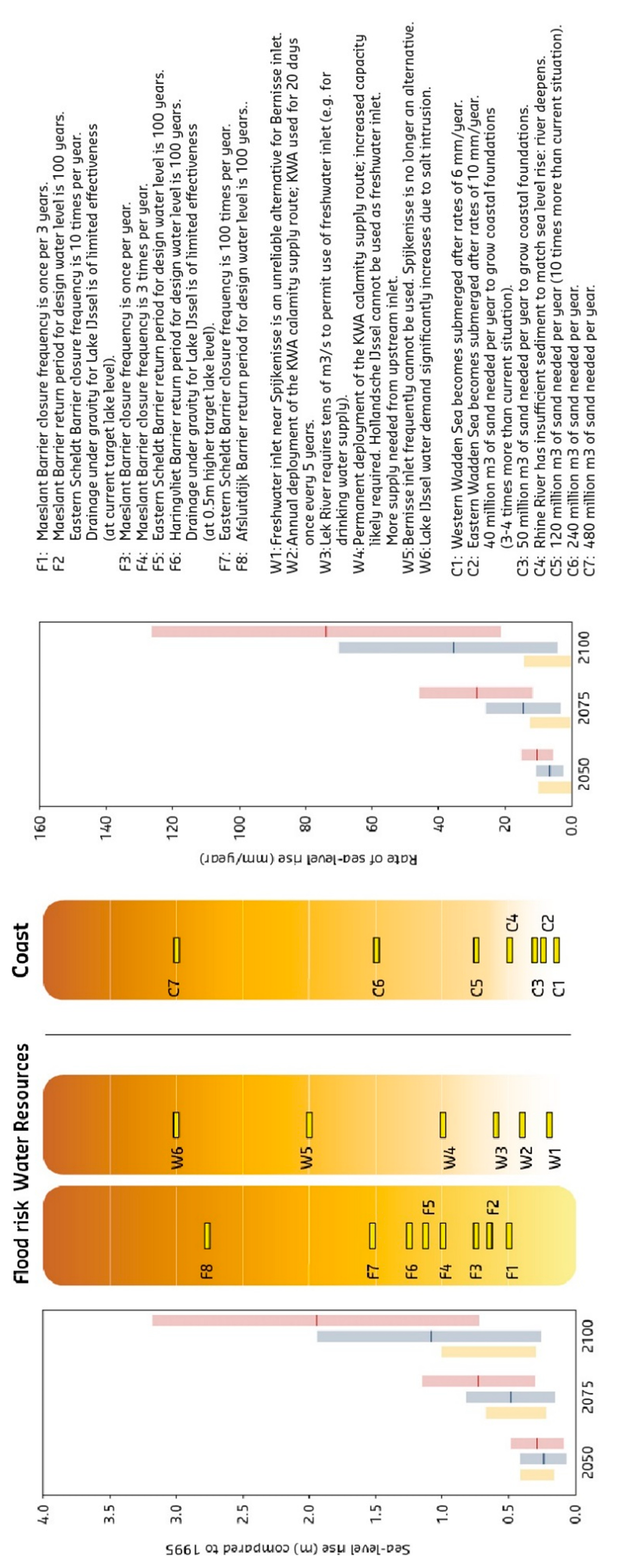
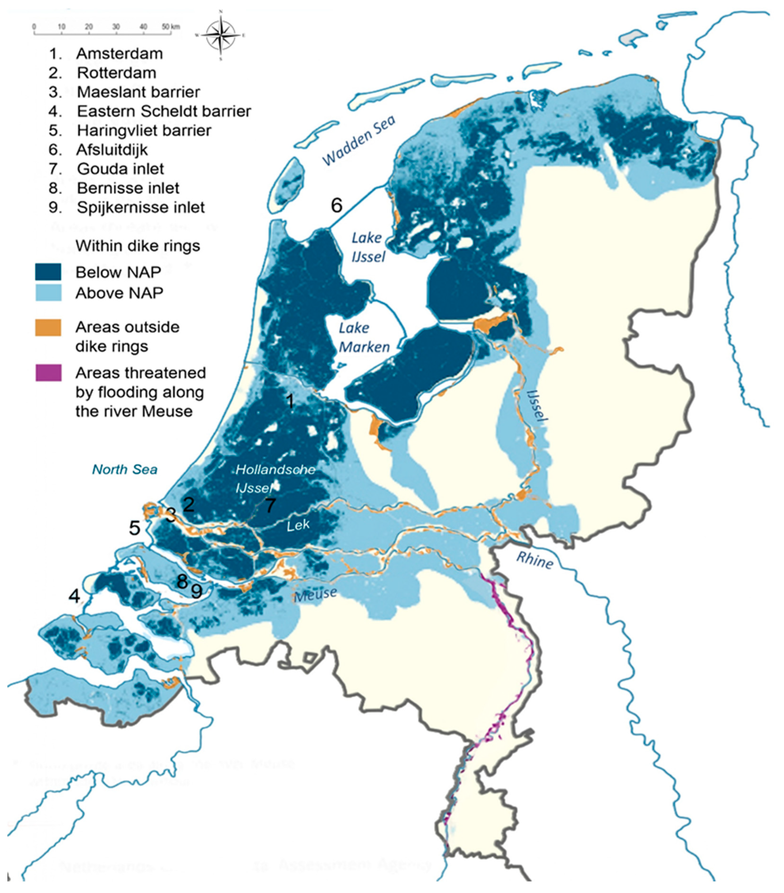
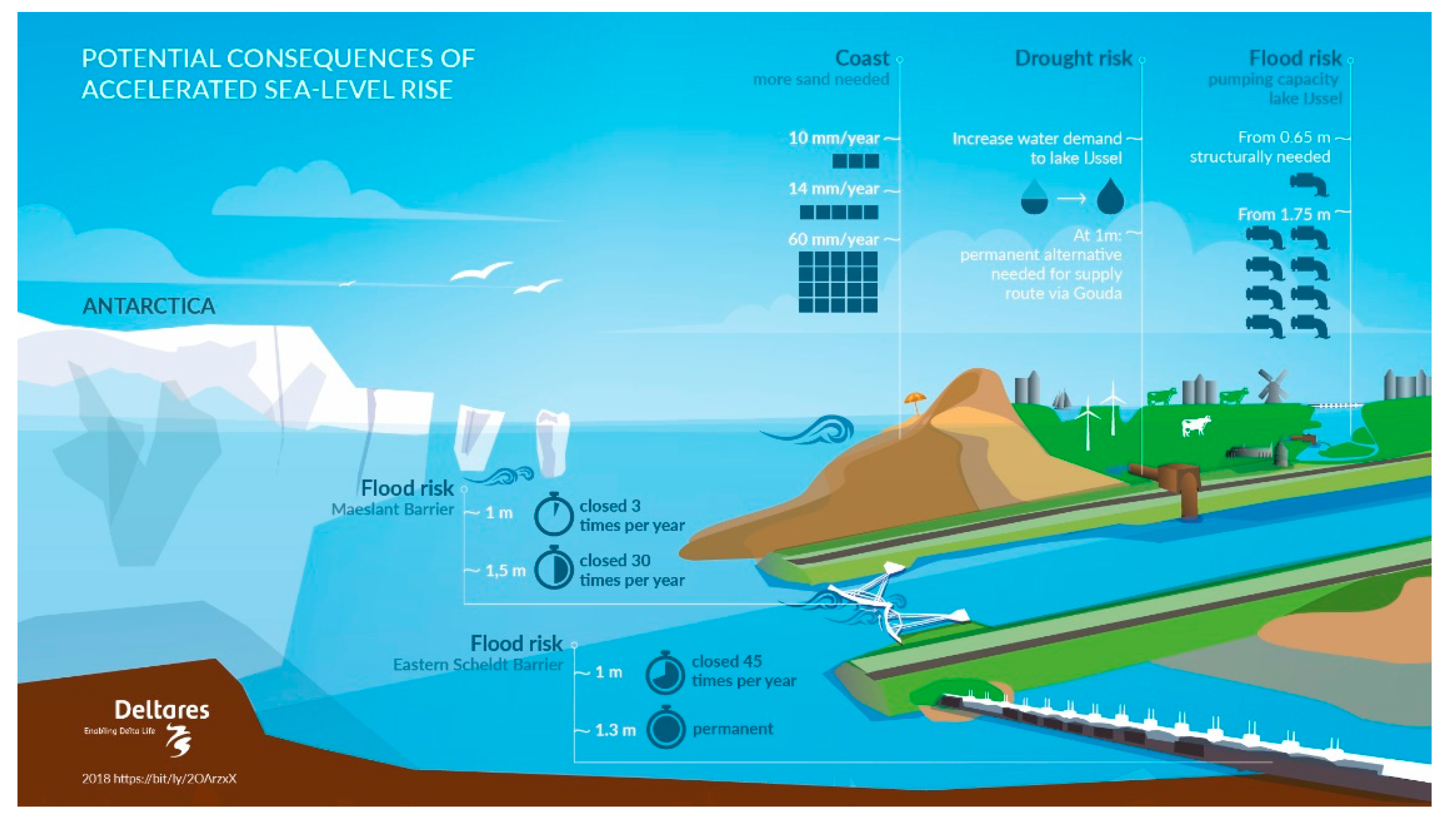
4.1. The Potential Impact of Sea-Level Rise on the Dutch Delta

An accelerated SLR may affect the Dutch delta in different ways. The consequences of a potential accelerated SLR on present water management structures and strategies according to the adopted ‘what if’ scenarios are described below. Figure 2 illustrates the potential consequences of SLR on coastal maintenance, water demand, pumping capacity, and closure frequency of storm surge barriers. Figure 3 summarizes some critical consequences (‘tipping points’) of SLR magnitude (left) or SLR rate (right) on flood defense and water supply infrastructure and coastal zone management. The most important locations are shown in Figure 1.
Maintenance of the sandy coastline requires increasing volumes of sand nourishments to compensate for erosion and to keep up with SLR. This volume is proportional to the annual rate of sea-level rise. The global averaged SLR accelerated to about 4 mm/year the last decade, but along the Dutch coast, this acceleration is difficult to assess due to large interannual variability in wind climate and thermal expansion. [Le Bars, personal communication]. With this annual SLR of 2 mm/year, the volume of sand nourishments on eroded beaches and erosive tidal channels is 12 million m3/year on average. An accelerated SLR may increase this volume at the end of the century with more than a factor 10 (K7 in Figure 3). The relatively shallow Dutch continental shelf (depth of 20–40 m) consists of vast sandy deposits originating from glacial times. The increase in potential demand for beach nourishments would make spatial reservations for sand extraction necessary, taking account of the rapid development of large offshore wind energy farms.
Large parts of the coastal area consist of intertidal basins, such as the Wadden Sea, which is a UNESCO heritage site. Preservation of the 4700 km2 intertidal habitats such as shoals and mudflats requires sediment supply that enables these areas to keep pace with SLR. Otherwise, these areas may lose surface area and eventually drown. This can have large consequences on ecology, fisheries, and recreation, and also on flood protection, since these shallow areas reduce wave action and hydraulic loads on the flood defenses. For the Wadden Sea, it is expected that natural sediment supply by tidal action may fall short when SLR exceeds an annual rate of 6–10 mm/year (which may be around 2050) [23]. (see also K1 and K2 in Figure 3).
Flood protection against storm surges is provided by a system of dams, seawalls, and storm surge barriers. With accelerating SLR and without improvements of the flood defenses, the current design conditions for these flood defenses may be met more frequently. The level of protection may drop and the flooding probability may increase. Storm surge barriers are of special interest, since SLR increases the closure frequency. E.g., the Maeslant barrier, which protects Rotterdam, is designed to close 1/10 per year (once every decade). At 1 m SLR, it may need to be closed 3 times per year (V4 in Figure 3), and at 1.5 m SLR, it may be closed 30 times a year. This may induce a larger maintenance effort. Furthermore, the barrier was not designed to close that often and may therefore meet its end-of-life time earlier than was originally intended. More importantly, it also increases the probability of a closure coinciding with a flood wave on the river, increasing riverine flood risk in the area that is protected by the barrier. To maintain the present level of flood protection, an upgrade of the storm surge barrier becomes necessary before the designed end-of-life of the barrier, and/or large dike improvement works.
Excessive river discharge and rainfall is discharged by gravity from large lakes and canals into the North Sea. With SLR, the interval during which gravity drainage into the sea is possible is gradually shortened, and consequently, the natural discharge capacity is reduced. To maintain the required discharge capacity, the sluices have to be widened and/or complemented with pumps. When SLR exceeds 0.65 m above the present level, the low tide along the Afsluitdijk may equal the level of Lake Ijssel. Then, discharge under gravity is no longer possible and drainage should be entirely performed by pumps. This requires a pumping capacity of about 1200–3200 m3/s, depending on the accepted lake level fluctuations. In the ‘what if’ scenarios, this may become necessary from 2070 onward. Artificial drainage of the river discharge of Rhine and Meuse through their present river outlets near Rotterdam may require even larger pumping capacities.
In the coastal region, there is a continuous inward saline influx in river mouths and through ground water into the deep lying polders. Presently, the influx through surface waters is counterbalanced by the outflow of fresh riverine water, except during periods of low discharge. Polders that are suffering from upwelling saline groundwater are flushed with fresh water that is transferred from upstream intakes, such as Gouda, which serves 1100 km2 of polder area. The Gouda intake supplies about 80 Mm3 per year on average, mainly during summer. With increasing SLR, the salinization influx may increase. Fresh water intakes for drinking water, agriculture, and industrial purposes may close more frequently or have to be transferred to more upstream fresh water locations. To maintain the present agricultural land use and crop types, the fresh water demand for flushing may increase, which requires expansion of the present supply route and supply volumes. For the Gouda intake, the required fresh water supply may increase to 120 Mm3 in 2100 and 185 Mm3 per year in 2200.
Most existing large flood and water management structures in the Netherlands are designed for a lifetime of 100–200 years, i.e., according to the present SLR of 2 mm/year, for an SLR of 0.20–0.40 m. An accelerated SLR (e.g., up to 30 mm/year) may reduce this lifetime significantly. Figure 4 illustrates that in the RCP8.5 scenario, the lifetime of a 50 cm SLR design may be reduced from 65 years presently to only 10 years at the end of the century. To solve this challenge, we must think of more robust measures that can handle a large SLR (to achieve a long lifetime), or measures that are adaptive (to gradually expand, reinforce, or increase in height when necessary), or more fundamentally, entirely different strategies of delta management.
The important message of these observations is that from 2050 onward, large uncertainty appears in the expected SLR, depending on what will occur with Antarctic land ice loss, but also that the potential consequences for the Dutch delta may be huge and may accumulate on all aspects that are relevant for delta management in a rather short time, i.e., several decades.

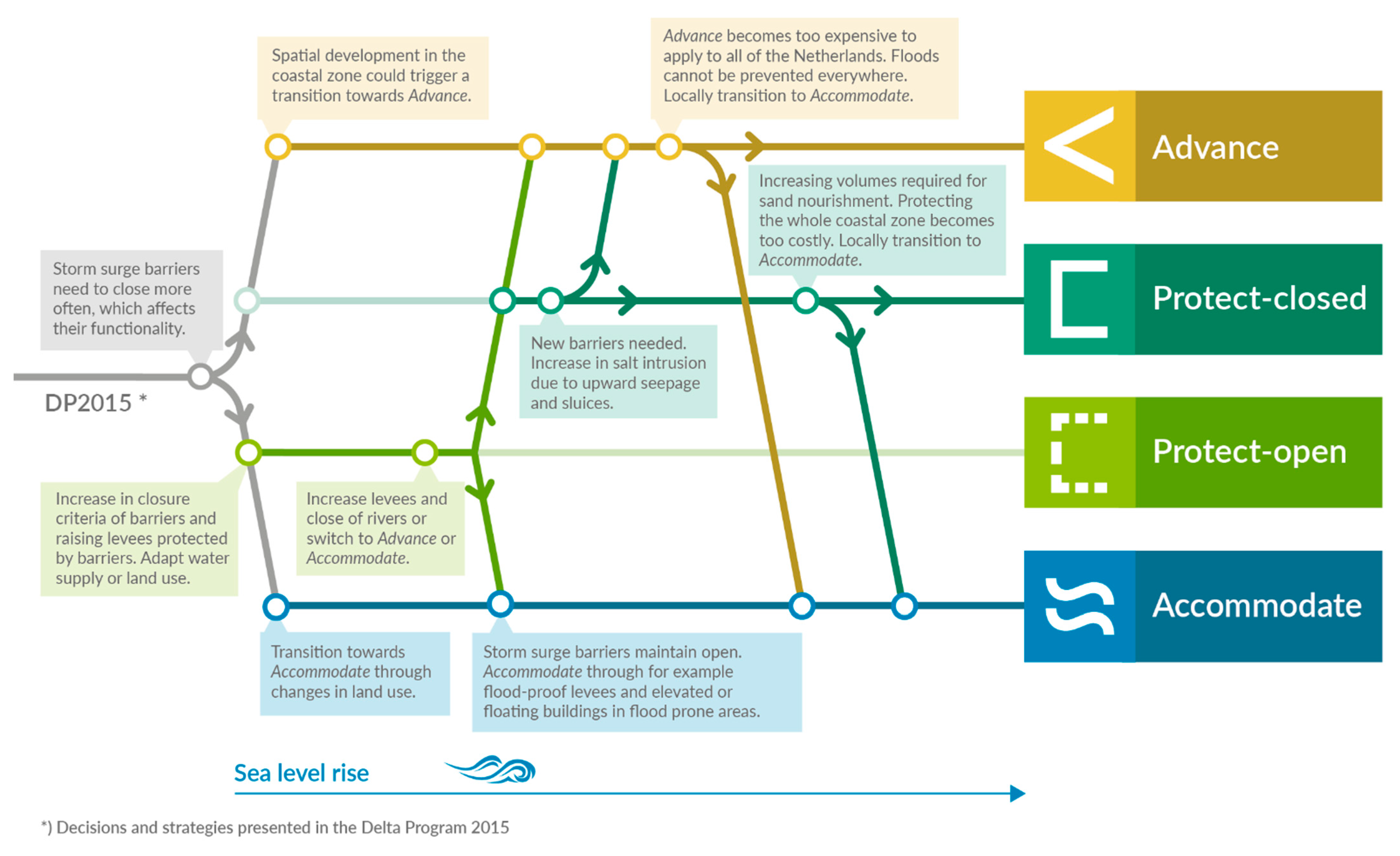
4.2. Strategies to Cope with Sea-Level Rise

Experiences with previous Dutch major water management programmes show that policy development, plan preparation, decision making, and implementation may take several decades: the Deltaworks programme, initiated after the devastating 1953 flood, took about 45 years to complete, and the Room for the River programme, initiated after the 1993 and 1995 flood events of the Rhine and Meuse Rivers, lasted 20 years until finalization. With these experiences in mind, and potential consequences of accelerated SLR emerging from 2050 onward, studies and preparations for new strategies should start now to be ready when this might become necessary.
In [5], three different types of strategies were distinguished:
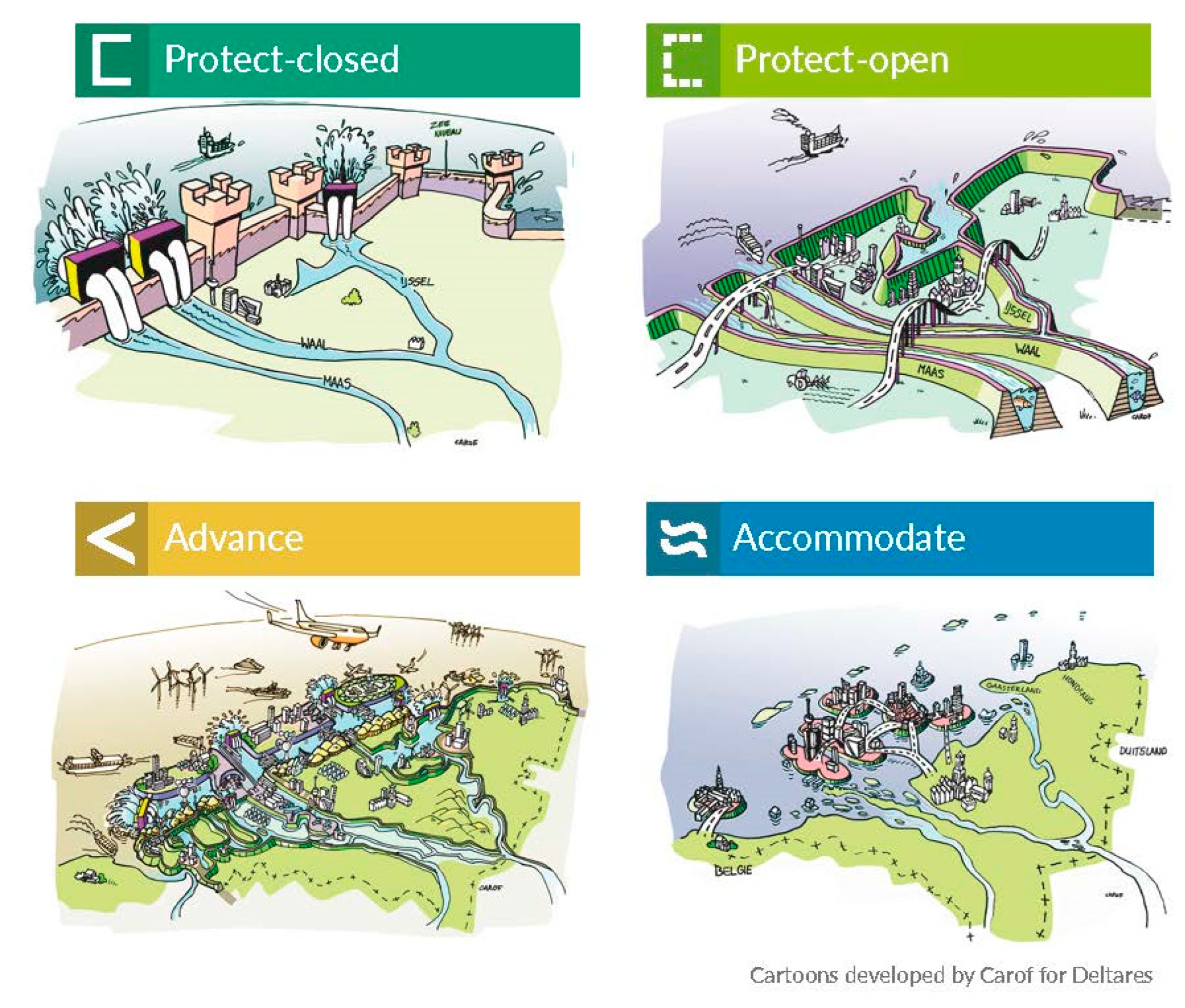
Retreat, which involves reducing the exposure to coastal hazards by moving people, assets, and activities landward to higher ground. This choice can be motivated by excessive economic or environmental impacts of protection or long-term adaptation needs;
Accommodate, which implies that people continue to use the land at risk but do not attempt to prevent the land from being flooded. This option includes creating emergency flood shelters, elevating buildings on piles or mounds, converting agriculture to fish farming, or growing flood or salt tolerant crops;
Protect, which involves hard structures such as seawalls and dikes, as well as nature-based solutions such as dunes and vegetation, to protect the land from the sea so that existing land uses can continue. Protection can be provided by strengthening the existing coastline or by advancing a higher new coastline.
With growing attention for SLR in the last decade, many ideas to cope with SLR have been proposed for the Dutch delta [22]. Inspired by the abovementioned IPCC typology for the Dutch delta, these strategies are now categorized as follows (see Figure 5, [24]):
Protect (‘freeze’): continue the present policy to preserve the territory of the Netherlands by increasing volumes of beach nourishments, and raising dikes and seawalls. Present land use can be continued, but requires increasing efforts in flood protection and water management. Regarding the estuaries, two variants of protection emerge:
(a)
Close them off from the sea completely by dams, navigation locks, and sluices. This ‘protect-closed’ strategy protects the inland area against SLR and the related salinization. However, handling river discharge requires enormous pumping stations, with a capacity of several thousand m3/s, in combination with large areas for temporary flood storage.
(b)
Maintain the open connection with the sea. In this ‘protect-open’ strategy, rising sea level extends its influence upstream along the rivers, flooding unembanked (harbor) areas and requiring extensive dike improvement programmes to maintain flood protection standards. In addition, a large inland area may be affected by salinization of surface waters.
The ‘accommodate’ strategy is based on the ‘living with water’ concept. For the Dutch delta, this could be a combination of ‘retreat’ (‘flee’, horizontal retreat) and ‘accommodate’ (vertical retreat, by creating mounds, raising buildings, or creating ring dikes to protects urban areas, or by introducing floating solutions). In this strategy, flood defenses are maintained to the present height, but not raised to rising sea level. As a result, low-lying areas may experience more frequent flooding (e.g., from presently 1:10.000 to 1:10 years in the future). This strategy may have a large societal impact since large parts of the country must be re-organized or abandoned and millions of inhabitants must adapt or migrate to higher ground.
The ‘advance’ (‘fight’) strategy is new compared to the original IPCC types. In this strategy, the present coastline is extended seaward to build a more robust coastal flood defense. It can be considered as a special kind of protect strategy, also creating 100–500 km2 of new land. A more radical alternative is the construction of a new (closed) coastline 10–20 km offshore, protecting the present coastline and creating a brackish reservoir in which river discharge during river flood events can be buffered before it is pumped across this new coastline. The present land use can be continued; moreover, the new coastline creates 500 km2 for urban and industrial developments, recreation, and nature, and possibly, a new airport. The sand volumes necessary to expand the present shoreface or to construct an offshore coastline vary between 10 and 20 billion m3.
These different strategies all involve prolonged and massive investments in construction and maintenance and have profound impacts on present and future land use. Especially, the ‘living with water’ strategy may cause large societal and political debate, since the Dutch culture has been for a thousand years based on protection against floods and reclaiming land from the sea. On the other hand, elements of this ‘amphibious’ strategy already exist locally, but are less known and widespread. For example, to provide additional flood discharge and storage capacity, in the former Noordwaard, polder houses have been removed or relocated to outside the flood plain or to mounds [25] (see Figure 6). Along parts of the coasts (e.g., Wadden Sea and Westerschelde), managed realignment is implemented to restore salt marshes and to aid coastal defense [26].
Policy development, decision making, elaboration, and implementation of the measures can take several decades. However, there is still a lot of uncertainty regarding future SLR, and starting a debate on the appropriate strategy right now may seem much too early when assuming a best-case scenario in which global warming is kept to a maximum of 2 °C, or even when considering the likely range of projections with a higher global warming scenario. On the other hand, the planned investments up to EUR 600 billion in housing, infrastructure, sustainable energy, and agriculture in flood-prone areas may substantially increase the future risk potential, and create a further ‘lock in’ of continued developments in low-lying flood-prone polders when fundamental choices are avoided.
The adaptive approach of the Delta Programme tries to find a balance between ‘too little too late’ and ‘too much too early’, to determine the measures that are necessary (or ‘low regret’) for now, maintain open options for future additional measures, and monitor developments in order to timely decide on accelerating present strategies or implementing additional measures [4]. Adaptation pathways connect present investment agendas with future perspectives by different combinations of measures, identifying where a change of strategy is still possible and how to avoid ‘lock in’ [27]. ‘Lock-in’ situations can be avoided by low-regret measures, including spatial reservations for potential future measures such as sand extraction, water storage, and flood defense reinforcements.
Adaptive strategies can benefit from flexible measures, which are easy to alter, speed up, or slow down depending on the measured climate change. Examples are ‘nature-based’ solutions such as beach nourishments. Robust measures that can cope with high-end scenarios may be preferred when the adjustment costs are relatively high compared to a more robust initial design [28]. This is especially the case with investments in ‘hard’ infrastructure such as locks, seawalls, and dams. An interesting hybrid example is the expansion of the pumping station in IJmuiden, where the expensive ground works and foundation was already constructed in a robust way for the worst-case scenario (SLR + 0.85 m in 2100), while the pumps are only placed for the best-case scenario (SLR + 0.35 m in 2100), creating flexibility to place additional pumps when necessary [29]
Potential adaptation pathways are presented in Figure 7 and can be explained as follows:
  • Until 2050, SLR projections for different emission scenarios vary only little. Therefore, a continuation of the present protect strategy seems logical as a first step. A complicated societal debate is avoided, choices can be postponed until more knowledge about SLR becomes available, and present land use can be continued by increasing the present technical measures in flood protection and water management, presumably up to a sea-level rise of 2 m and a related rate of SLR. The increasing volumes involved in beach nourishments (up to 60 million m3/year) can be dredged on the Dutch continental shelf. This strategy largely depends on scaling up present sand extraction and beach nourishments operations of generally 1–5 million m3 per project. An interesting pilot is the so-called ‘Sand motor’, a 1.28 km2 beach nourishment of 21.5 million m3, costing about EUR 70 million. After 10 years of monitoring, it was concluded that the ‘Sand motor’ acted as a ‘feeder beach’ from which the sand is transported to adjacent dunes and beaches by natural processes such as wind, tidal currents, and waves [30]. It also illustrated the ‘benefits of scale’ effect, since such larger volumes enable the use of more efficient large vessels and nourishment techniques, and reduces the costs of material mobilization and demobilization costs for ground works. As a consequence, the usual beach nourishment costs were almost halved.
  • In addition to these kind of pilots, low-regret measures can be taken, such as spatial reservations for sand extraction in the North Sea, to avoid conflicts with other marine users, including wind farm developers. Nevertheless, a large loss of intertidal areas in the Wadden Sea cannot be prevented if SLR rates consistently exceed 6 mm/year (western Wadden Sea) or 10 mm/year (Eastern Wadden sea). Nor can the salt intrusion be fully avoided. In this way, the protection pathway is continued, with the risk of large transfer cost for future generations, if a shift to other strategies is needed.
  • With rising sea levels, the first dilemma that may emerge is whether to permanently close the estuaries or to keep them open to facilitate free river discharge. To keep both options open in the coming decades, it is necessary to avoid new developments in unembanked areas (or at least make them flood-proof), and reserve space for future dike improvements. A first inventory shows that future dike raising requires 12–17 m additional horizontal space per meter raised. This requires valuable space, especially in urban areas such as Rotterdam, which can only be used for temporary activities. Furthermore, in the closed option, drainage of river discharge requires large pumping capacity, up to several thousand m3/s or even more. This pumping requirements can be reduced when flood waters can be temporarily stored. This storage capacity can be found in present water systems, or in creating new systems in the coastal zone, attached to the river mouths. Model simulations can help find the optimum combination of dike raising, storage volumes, and pumping capacity.
  • Regarding agriculture and horticulture, a gradual transition to salt (and drought)-tolerant crops is low-regret, since salinization of the coastal area is expected in both the retreat and protection strategies.
  • With continued SLR and increasing technical efforts, a fundamental choice between ‘advance’ or ‘retreat’ becomes inevitable. The ‘advance’ strategy can be seen as a next step in the present protective strategy, heavily relying on technical measures such as flood defenses and pumps. Therefore, some experts advocate to start with this strategy already, and avoid short-term expenses on maintenance and on upgrading the present flood and water management infrastructure. The retreat strategy marks a significant ‘change of mind’, which may be reached after a long societal debate, or become reality when natural disaster creates a ‘fait accompli’.
Worldwide, many examples exist of large-scale technical measures that may be necessary to handle a SLR of 2 m or even more. Examples are the Japanese 10 m high tsunami seawalls (costs up to USD 30 million/km [31]) and even more expensive ‘super levees’ such as the 36 m high and 33 km long Seamangum closure dike in South Korea (cost USD 1.7 billion, [32], the 300 m3/s Mubarak pumping station in the Aswan dam, large-scale land reclamations by sand nourishments for urban development in Palm Jumeirah, Dubai (cost USD 12 billion for 5.6 km2) and Eko City, Lagos (USD 6 billion for 10 km2) [33]. Additionally, examples exist of (managed) retreat or ‘living with water’ measures, such as mounds and shelters in the tsunami-affected coastal zone of Japan, cyclone shelters in Bangladesh, and raised buildings in the Mississippi delta, but these areas are often less populated than the Dutch delta.

4.3. The First Step

A choice for one of these strategies has large consequences for present and future land use, requires a solid preparation and societal debate, and is not necessary at the present rate of SLR, as there is still time to prepare. Furthermore, the Netherlands does not necessarily have to choose only one of the four strategies. A regional differentiation of the strategies, in which some areas receive extra protection while in other areas a retreat or accommodate strategy is applied, is a viable option as well, especially when there are large differences in population density and flood hazard.
To support a timely preparation on SLR, in 2019, the Delta Commissioner and Minister of Infrastructure and Water Management jointly initiated a 6-year comprehensive research programme that consists of the following tracks [34]:
  • research aimed to reduce the uncertainty regarding SLR. This requires international cooperation on polar research, but also on monitoring SLR in coastal seas;
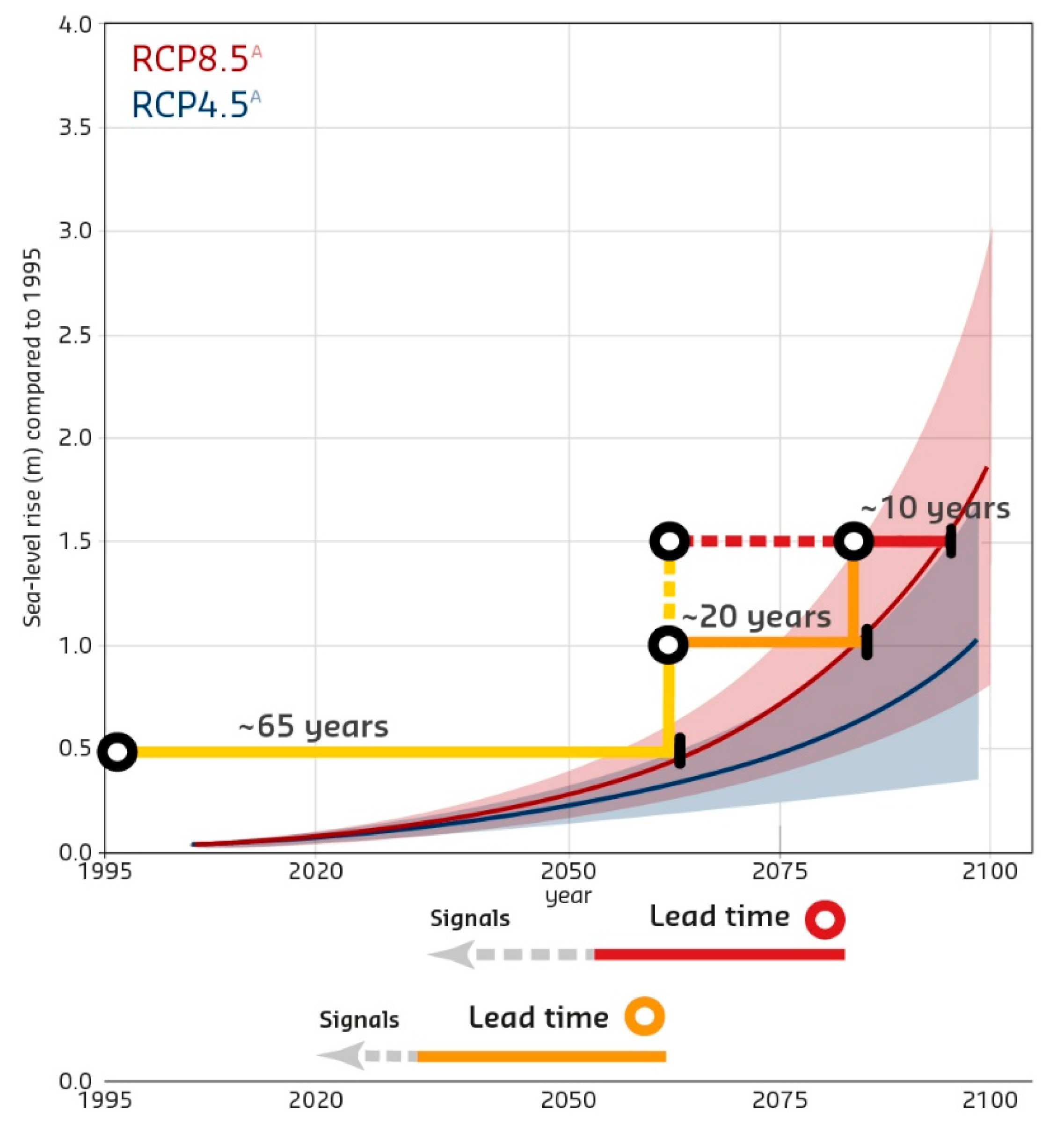
  • develop a method to signal a potential acceleration of SLR timely and with sufficient confidence. This involves statistical research on SLR data and projections;
  • establish the potential effects on the flood risk and water management of the Dutch delta and related infrastructure and establish the lifetime of the present policies. Detailed model computations for different SLR scenarios must be performed to predict future coastal erosion, necessary beach nourishment volumes, hydraulic loads and required flood defense strengthening, storage and pumping capacities, and increase of fresh water supply. Special attention is paid to the discharge of river water with the rising sea-level [35], which is a major challenge for many deltas worldwide;
  • explore long-term options which might become necessary when present policies become short. In this situation, the present territory and land use of the Netherlands might be affected by regular or permanent flooding and salt intrusion. In cooperation with other authorities and NGOs, it must be explored whether present investment agendas on, e.g., housing, infrastructure, and sustainable energy may occupy land that might be necessary for future strategies to deal with SLR, and how these agendas can be aligned to create synergy with these future strategies;
  • prepare the implementation of the necessary policies and measures by:
    o
    collecting expertise and knowledge on large-scale long-term societal transitions;
    o
    starting pilots to gain experience with the possibilities to scale up present techniques and methods (e.g., building with nature);
    o
    propose spatial reservations for future sand extraction, flood protection, water discharge, storage, and supply; and
    o
    introducing the adaptive approach in the design of projects that are planned for the coming years in housing, infrastructure, and replacement of present (aging) infrastructure.
This research programme is a joint cooperation of several ministries, water management authorities, provinces, municipalities, knowledge institutes and universities, private parties, NGOs, and neighboring countries, under the leadership of the Delta Programme Commissioner and Minister of Infrastructure and Water Management. The results will become available in 2026, to give input to the next 6-year evaluation of the Delta Programme.

5. Discussion and Conclusions

SLR is becoming a worldwide threat for coastal areas, especially because of its potentially accelerating rate. Whether and when this will occur is still uncertain, and depends largely on the success of CO2 reduction measures, global warming, and the response of Antarctica’s land ice. The exploration of adaptation pathways helps to manage this uncertainty by enabling timely adaptation and limiting regret of investments. As sea levels rise faster, adaptive measures must be implemented at an increasing frequency or to a higher sea level. This is challenging for investments with a long lifetime or for measures that need decades to prepare and implement in an orderly way, such as coastal defenses or managed retreat. With accelerating SLR, the time required may become a limit. Therefore, long-term planning and accelerated implementation, particularly in the next decade, is important to close the gaps between present and necessary adaptation [2].
Using the Dutch approach as an inspiration for other urbanized coastal zones threatened by SLR, it is recommended to start a comprehensive programme consisting of:
  • research into the behavior of Antarctic ice, combined with the development of a method to signal SLR acceleration in a timely way with sufficient confidence;
  • research into the consequences of accelerated SLR on present water management infrastructure such as flood defenses, storm surge barriers, locks and pumping stations, and fresh water intake locations. How will SLR affect their lifetime, maintenance, replacement, or reconstruction? Consequently, what will be the effect on the land use that this affected infrastructure serves? Which strategic choices in water management and land use strategies become inevitable? E.g., is the present type of fresh-water-based agriculture in the coastal zone sustainable with increasing salinization due to SLR? Or do we continue with new urban development in low-lying coastal areas which require increasing efforts to maintain dry?;
  • the exploration of long-term strategies (e.g., ‘protect’, ‘advance’, ‘accommodate’, and ‘retreat’) that might become necessary when present policies start to fail. Vice versa, identify necessary short-term measures to keep these future strategies open and avoid regret investments. An important no-regret measure is the spatial reservation for future sand extraction (for beach nourishments) and for future expansion of flood defenses, water discharge, and water storage.
  • flexible measures, which are important to bridge the coming decades of uncertainty in SLR. Nature-based solutions, such as beach nourishments or stimulating natural sedimentation on flood defense forelands, are relatively cheap and more flexible to adapt to changing conditions than concrete structures. In addition, they have beneficial side effects on, e.g., nature restoration and recreation. Pilots may be helpful to improve the effectiveness of these measures and establish their ‘scaling up’ potential, as illustrated by the Sand motor mega beach nourishment [30].
  • adaptive design. When decisions have to be made regarding the (re)construction of long-lifetime robust infrastructure, an adaptive design should be promoted, to make future expansion possible without excessive costs.
The first results of this Dutch sea-level rise programme illustrate the large potential impact of accelerating SLR on densely populated coastal areas. Although adaptive options can be formulated, the implementation will require large and long-lasting efforts and cause strong societal and political debates. This underlines the need to reduce greenhouse gas emissions in order to mitigate SLR, avoid these dramatic consequences, and reduce adaptation efforts.

Author Contributions

Conceptualization, J.v.A., M.H. and F.D.; methodology, M.H. and F.D.; software, F.D. and M.H.; formal analysis and investigation, F.D. and M.H.; writing—original draft preparation, J.v.A., M.H. and F.D.; writing—review and editing, J.v.A.; visualization, M.H. All authors have read and agreed to the published version of the manuscript.

Funding

This research received no external funding.

Institutional Review Board Statement

Not applicable.

Informed Consent Statement

Not applicable.

Conflicts of Interest

The authors declare no conflict of interest.

References

  1. Global Commission on Climate Adaptation. Adapt Now: A Global Call for Leadership on Climate Resilience; Global Center on Adaptation: Rotterdam, The Netherlands; World Resources Institute: Washington, DC, USA, 2019. [Google Scholar]
  2. IPCC. Summary for Policymakers. In Climate Change 2022: Impacts, Adaptation and Vulnerability. Contribution of Working Group II to the Sixth Assessment Report of the Intergovernmental Panel on Climate Change; Cambridge University Press: Cambridge, UK, 2022; Available online: https://www.ipcc.ch/report/ar6/wg2/ (accessed on 9 May 2022).
  3. IPCC. Summary for Policymakers. In Climate Change 2021: The Physical Science Basis. Contribution of Working Group 1 to the Sixth Assessment Report of the Intergovernmental Panel on Climate Change; Cambridge University Press: Cambridge, UK, 2021; Available online: https://www.ipcc.ch/report/ar6/wg1/#SPM (accessed on 20 March 2022).
  4. Bloemen, P.J.T.M.; Hammer, F.; Van der Vlist, M.J.; Grinwis, P.; Van Alphen, J. DMDU into practice: Adaptive Delta Management in the Netherlands. In Decision Making under Deep Uncertainty: From Theory to Practice; Marchau, V.A.W.J., Walker, W.E., Bloemen, P.J.T.M., Popper, S.W., Eds.; Springer International Publishing: Cham, Switzerland, 2019; pp. 321–351. [Google Scholar] [CrossRef] [Green Version]
  5. IPCC. Strategies for Adaptation to sea Level Rise; Report of the Coastal Zone Management Subgroup, IPCC Response Strategies Working Group; Ministry of Transport and Public Works, Rijkswaterstaat, Tidal Water Division: The Hague, The Netherlands, 1990; Available online: https://puc.overheid.nl/rijkswaterstaat/doc/PUC_26288_31/ (accessed on 9 May 2022).
  6. OECD. Water Governance in the Netherlands, Fit for the Future? OECD Studies on Water; OECD Publishing: Paris, France, 2014. [Google Scholar] [CrossRef]
  7. Deltacommissaris. The 2022 Delta Programme, Every New Development Climate-Proof; Ministry of Infrastructure and Water Management: The Hague, The Netherlands, 2021; Available online: https://english.deltaprogramma.nl/documents/publications/2021/09/21/dp-2022-in-english---print-version (accessed on 20 March 2022).
  8. Deltacommissaris. The 2011 Delta Programme, Working on the Delta; Ministry of Transport; Public Works and Water Management: The Hague, The Netherlands, 2010. [Google Scholar]
  9. Haasnoot, M.; van’t Klooster, S.; Van Alphen, J. Designing a monitoring system to detect signals to adapt to uncertain climate change. Glob. Environ. Chang. 2018, 52, 273–285. [Google Scholar] [CrossRef]
  10. Haasnoot, M.; Kwadijk, J.; Van Alphen, J.; LeBars, D.; Van den Hurk, B.; Diermanse, F.; Van der Spek, A.; Oude Essink, G.; Delsman, J.; Mens, M. Adaptation to uncertain sea-level rise: How uncertainty in Antarctic mass-loss impacts coastal adaptation strategy of the Netherlands. Environ. Res. Lett. 2020, 15, 034007. [Google Scholar] [CrossRef]
  11. Deltacommissaris. The 2015 Delta Programme, Working on the Delta. The Decisions to Keep the Netherlands Safe and Liveable; Ministry of Infrastructure and the Environment: The Hague, The Netherlands, 2014. [Google Scholar]
  12. Royal Dutch Meteorological Institute KNMI. KNMI’14 Climate Scenarios for the Netherlands; A Guide for Professionals in Climate Adaptation; KNMI: De Bilt, The Netherlands, 2015; 34p, Available online: https://www.knmiprojects.nl/projects/climate-scenarios/documents/publications/2015/01/01/brochure-knmi14-climate-scenarios (accessed on 24 December 2021).
  13. IPCC. Climate Change 2014: Synthesis Report. Contribution of Working Groups I, II and III to the Fifth Assessment Report of the Intergovernmental Panel on Climate Change; IPCC: Geneva, Switzerland, 2014; 151p. [Google Scholar]
  14. Deltacommissaris. The 2018 Delta Programme, Continuing the Work on a Sustainable and Safe Delta; Ministry of Infrastructure and the Environment: The Hague, The Netherlands, 2017. [Google Scholar]
  15. Hekman, A.; Booister, N. Ruimte voor de Toekomst, Flexibel Invullen van Investeringsopgaven om Effecten van Zeespiegelstijging in de Toekomst te Kunnen Opvangen; White Paper; SWECO Nederland: De Bilt, The Netherlands, 2021. (In Dutch) [Google Scholar]
  16. Broderick, C.; Murphy, C.; Wilby, R.L.; Matthews, T.; Prudhomme, C.; Adamson, M. Using a scenario-neutral framework to avoid potential maladaptation to future flood risk. Water Resour. Res. 2019, 55, 1079–1104. [Google Scholar] [CrossRef] [PubMed]
  17. Kwadijk, J.; Haasnoot, M.; Mulder, J.P.M.; Hoogvliet, M.M.C.; Jeuken, A.B.M.; Van der Krogt, R.A.A.; Van Oostrom, N.G.C.; Schelfhout, H.A.; Van Velzen, E.H.; Van Waveren, H.; et al. Using adaptation tipping points for climate change and sea level rise: A case study in the Netherlands. Wiley Interdiscip. Rev. Clim. Chang. 2010, 1, 729–740. [Google Scholar] [CrossRef]
  18. Slangen, A.; Haasnoot, M.; Winter, G. Rethinking Sea-Level Projections Using Families and Timing Differences. Earth Futures 2022, 10, e2021EF002576. [Google Scholar] [CrossRef]
  19. Zijl, F.; Sumihar, J.; Verlaan, M. Application of data assimilation for improved operational water level forecasting on the northwest European shelf and North Sea. Ocean Dyn. 2015, 65, 1699–1716. [Google Scholar] [CrossRef] [Green Version]
  20. Oude Essink, G.H.P.; Van Baaren, E.S.; De Louw, P.G.B. Effects of climate change on coastal groundwater systems: A modeling study in the Netherlands. Water Resour. Res. 2010, 46. [Google Scholar] [CrossRef]
  21. De Lange, W.J.; Prinsen, G.F.; Hoogewoud, J.C.; Veldhuizen, A.A.; Verkaik, J.; Oude Essink, G.H.P.; Van Walsum, P.E.V.; Delsman, J.R.; Hunink, J.C.; Massop, H.T.L.; et al. An operational, multi-scale, multi-model system for consensus-based, integrated water management and policy analysis: The Netherlands Hydrological Instrument. Environm. Model. Softw. 2014, 59, 98–108. [Google Scholar] [CrossRef] [Green Version]
  22. Deltares. Kustwiki. Available online: https://publicwiki.deltares.nl/display/KWI/Projects (accessed on 28 March 2022). (In Dutch).
  23. Van der Spek, A.J.F. The development of the tidal basins in the Dutch Wadden Sea until 2100: The impact of accelerated sea-level rise and subsidence on their sediment budget—A synthesis. Netherlands J. Geosci. 2018, 97, 71–78. [Google Scholar] [CrossRef] [Green Version]
  24. Haasnoot, M.; Diermanse, F.; Kwadijk, J.; de Winter, R.; Winter, G. Strategieën voor adaptatie aan hoge en versnelde zeespiegelstijging, een verkenning; Deltares rapport 11203724-004; Deltares: Delft, The Netherlands, 2019. (In Dutch) [Google Scholar]
  25. Van Alphen, S. Room for the River: Innovation, or Tradition? The Case of the Noordwaard. In Adaptive Strategies for Water Heritage; Hein, C., Ed.; Springer: Cham, Switzerland, 2020; pp. 309–323. [Google Scholar] [CrossRef] [Green Version]
  26. Marijnissen, R.J.C.; Kok, M.; Kroeze, C.; Van Loon-Steensma, J.M. Flood risk reduction by parallel flood defences—Case-study of a coastal multifunctional flood protection zone. Coast. Eng. 2021, 167, 103903. [Google Scholar] [CrossRef]
  27. Haasnoot, M.; Kwakkel, J.H.; Walker, W.E.; Ter Maat, J. Dynamic Adaptive Policy Pathways: A New Method for Crafting Robust Decisions for a Deeply Uncertain World. Glob. Environ. Chang. 2013, 23, 485–498. [Google Scholar] [CrossRef] [Green Version]
  28. Van Alphen, J. The Delta Programme and updated flood risk management policies in the Netherlands. J. Flood Risk Manag. 2016, 9, 310–319. [Google Scholar] [CrossRef]
  29. De Neuville, R.; Smet, K.; Cardin, M.A.; Ranjbar-Bourani, M. Dynamic adaptive planning (DAP): The case of intelligent speed adaptation. In Decision Making under Deep Uncertainty: From Theory to Practice; Marchau, V.A.W.J., Walker, W.E., Bloemen, P.J.T.M., Popper, S.W., Eds.; Springer International Publishing: Cham, Switzerland, 2019; pp. 223–252. [Google Scholar] [CrossRef] [Green Version]
  30. Available online: Sand Motor—Building with Nature Solution to Improve Coastal Protection along Delfland Coast (The Netherlands). Available online: https://climate-adapt.eea.europa.eu/metadata/case-studies/sand-motor-2013-building-with-nature-solution-to-improve-coastal-protection-along-delfland-coast-the-netherlands (accessed on 20 March 2022).
  31. Seven Years after Tsunami, Japanese Live Uneasily with Seawalls. Available online: https://www.reuters.com/article/us-japan-disaster-seawalls/seven-years-after-tsunami-japanese-live-uneasily-with-seawalls-idUSKCN1GL0DK (accessed on 20 March 2022).
  32. Saemangeum Seawall. Available online: https://en.wikipedia.org/wiki/Saemangeum_Seawall (accessed on 20 March 2022).
  33. Out of the Deep: 7 Massive Land Reclamation Projects. Available online: https://ww3.rics.org/uk/en/modus/natural-environment/land/out-of-the-deep--7-massive-land-reclamation-projects--.html (accessed on 20 March 2022).
  34. Sea Level Rise Knowledge Programme. Available online: https://english.deltaprogramma.nl/delta-programme/knowledge-development/sea-level-rise-knowledge-programme (accessed on 30 March 2022).
  35. De Bruijn, K.; Diermanse, F.L.M.; Weiler, O.M.; De Jong, J.S.; Haasnoot, M. Protecting the Rhine-Meuse delta against sea level rise: What to do with the river’s discharge? J. Flood Risk Manag. 2022, e12782. [Google Scholar] [CrossRef]
Figure 2. The consequences of accelerated SLR for the main elements of Dutch water management.
Water 14 01527 g002
Figure 3. The consequences of accelerated SLR on measures related to flood risk, water management, and coastal maintenance. Left panel is sea-level height, right panel is SLR rate. The colored bars represent different SLR scenarios for the Netherlands: yellow = Delta scenarios 2014, blue: RCP 4.5, and pink: RCP8.5. The horizontal yellow bars in the three central columns represent the tipping points in present flood risk, water management, and coastal management policies, referred to by codes and explained below the diagram (Reprinted with permission from Haasnoot et al., 2020 [10]).
Water 14 01527 g003
Figure 4. The effect of accelerated SLR on the lifetime of investments. In the present situation, a design for 50 cm holds 65 years. The potential acceleration later this century reduces the lifetime of a 50 cm design to about 10 years (Reprinted with permission from Haasnoot et al., 2020 [10]).
Water 14 01527 g004
Figure 5. Potential types of strategies for the Netherlands to adapt to accelerated SLR (copyright of Carof, for Deltares).
Water 14 01527 g005
Figure 6. Relocated houses on flood-free mounds in Noordwaard flood storage and bypass area (picture from Brabants Dagblad).
Water 14 01527 g006
Figure 7. Adaptation pathways for the Netherlands to adapt to accelerated SLR. DP2015 represents the present strategies, adopted in 2014 [11].
Water 14 01527 g007
Publisher’s Note: MDPI stays neutral with regard to jurisdictional claims in published maps and institutional affiliations.

