Article

Identification Sources and High-Risk Areas of Sediment Heavy Metals in the Yellow River by Geographical Detector Method

1
School of Environmental and Municipal Engineering, Lanzhou Jiaotong University, Lanzhou 730070, China
2
Key Laboratory of Yellow River Water Environment in Gansu Province, Lanzhou Jiaotong University, Lanzhou 730070, China
*
Author to whom correspondence should be addressed.
Water 2021, 13(8), 1103; https://doi.org/10.3390/w13081103
Submission received: 1 March 2021 / Revised: 20 March 2021 / Accepted: 13 April 2021 / Published: 16 April 2021
(This article belongs to the Section Water Erosion and Sediment Transport)

Abstract

:
In order to determine the key influencing factors, risk areas, and source pathways of heavy metals in the sediment of the Yellow River, 37 samples were collected in the surface sediment (0–5 cm) of the Inner Mongolia section of the Yellow River main stream for the determination of heavy metals copper (Cu), nickel (Ni), zinc (Zn), chromium (Cr), lead (Pb), and cadmium (Cd). Based on the geographical detector model (GDM) and ArcGIS 10.2 software, this paper selected 6 heavy metals and 15 influencing factors, including 8 natural factors and 7 anthropogenic factors, to detect key influencing factors, risk areas, and sources of heavy metals. The results showed that: (1) The average contents of heavy metals Cr and Cd in the sediments exceeded the average value in soil, the world average concentration in the shales, and the first-level standard of soil environmental quality in China, and they were the main risk metals; (2) Vegetation coverage (VC) was the largest influencing factor for the spatial distribution of heavy metals in the sediment, followed by per capita income (PI), and land use type (LUT) and road network density (RD) were smaller influencing factors. The interactions of the factors were enhanced; (3) The Wuhai section for a risk area was mainly polluted by Cd and Pb, which were caused by atmospheric deposition and industrial emission. The Baotou section for a risk area was mainly polluted by Cr, which mainly originated from river transportation and industrial discharge. The conclusions can provide a scientific basis for the environmental protection and management of the different areas in the Inner Mongolia section of the Yellow River.

1. Introduction

Heavy metals are toxic [1] and can accumulate within the bodies of humans, endangering health [2]. At present, heavy metals Cu, Ni, Zn, Cr, Pb, and Cd have been listed as environmental pollutants of priority control in China [3]. Sediments are sources and sinks of river heavy metals. When environmental conditions such as pH, electrical conductivity (EC), chemical oxygen demand (COD), and organic matter change, heavy metals fixed in sediments can be released from sediments again and cause secondary river pollution [4]; therefore, sediments act as indicators of heavy metal pollution in rivers [5]. Rivers are mainly available resources of freshwater for human survival and development. Therefore, heavy metals in river sediments have been a research hotspot domestically in China and internationally [6].
Many achievements have been obtained on the concentration characteristics, spatial and temporal distribution, risk assessment, and source determination of heavy metal pollution in river sediments [7,8,9,10]. However, research on influencing factors is less prominent, with studies typically focusing on the analysis of single-factor influences, such as industry [11], agriculture [12], land use type [13], vegetation [14], pH value [15], salt content [16], total organic matter [17], and economic development [18], etc. There are few reports on the effects of multiple factors on heavy metals in river sediments. At present, multiple statistical methods such as regression analysis [19], correlation analysis, principal component analysis, and cluster analysis are often employed to determine key influencing factors [20,21]. These methods do not take into account the spatial characteristics of the factors and only use statistical methods to determine the main influencing factors by analyzing causal relationships between the factors. The factor type in these methods must be numerical rather than qualitative. The geographic detector model (GDM) proposed by Wang et al. in 2010 [22] considers the spatial features of factors in employing statistical analysis. Therefore, GDM requires that geographical factors (heavy metals) and their influencing factors should first exist in spatial variability. If a specific influencing factor contributed to heavy metals, this heavy metal would show a spatial distribution similar to that of the influencing factor. The GDM can quantitatively detect influence degrees not only each factor but also their interaction. In addition, GDM has no restriction on factor type, including numerical and qualitative types. On the whole, GDM is a useful tool to answer four questions: (1) Among these influencing factors, what are the main contributors to heavy metal pollution? (2) What is the degree of influence of each factor? (3) Are the influences of these factors on heavy metals independent or mutual? (4) Where are the high-risk areas of heavy metal pollution? In recent years, GDM has been proved to be feasible and applied in many fields, such as pollution [23], ecology [24], economy [25], geography [26], etc.
The Yellow River, called “mother river” in China, is the main water source for the regions it passes through, including the Inner Mongolia autonomous region, and its water quality is associated with the economic development and ecological security of these regions [27]. With the rapid development of industry and agriculture in China, a lot of wastewater containing heavy metals is discharged into the Yellow River, causing heavy metal pollution, especially Cd and Cr [28]. Previous research on sediment heavy metals in the Yellow River focused on analyzing the spatial distribution and assessing pollution [28,29,30]. However, this research did not determine the contributions of influencing factors to the concentration of sediment heavy metals. The identification of sources of heavy metals and high-risk areas was important to formulate policies for controlling heavy metal pollution in the Yellow River basin.
Therefore, the research objects of this paper considered 6 sediment heavy metals and 15 influencing factors in the Inner Mongolia section of the upper stream Yellow River. Based on the GDM, the research purposes were as follows: (1) to assess the pollution level and analyze spatial distribution characteristics of heavy metals; (2) to identify the key factors influencing the spatial distribution of heavy metals and the type of interaction between factors; (3) to discern the main risk areas and their main heavy metal pollutants; (4) to identify heavy metal sources according to the characteristics of the study area.

2. Materials and Methods
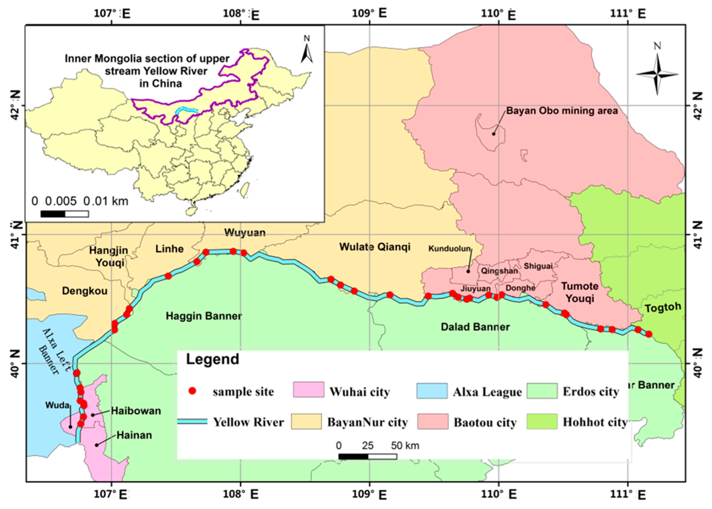
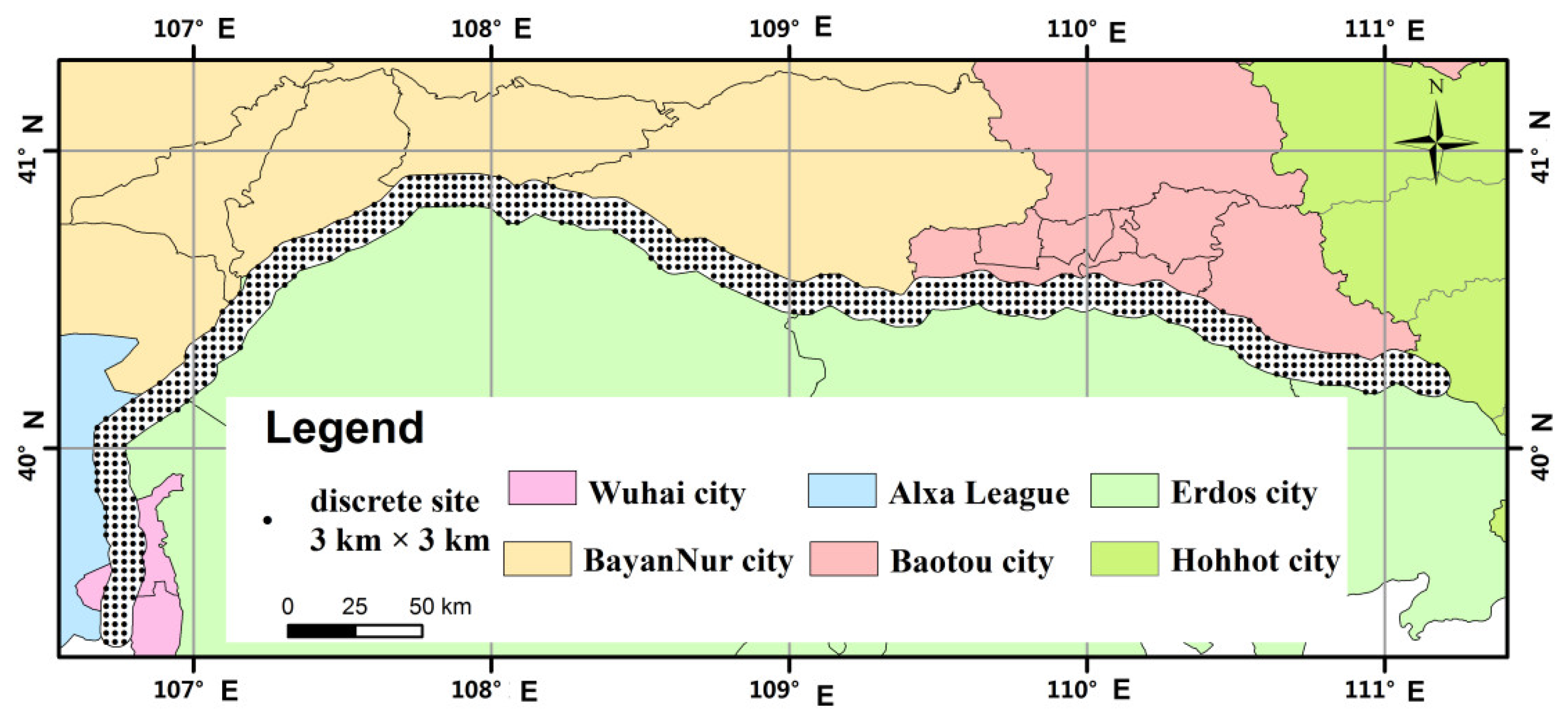
2.1. Study Area

The study area focuses on the Inner Mongolia section located in the upper stream Yellow River, which flows through Wuhai City (Hainan, Wuda, and Haibowan District), Alxa League (Alxa Left Banner), Byan Nur City (Dengkou, Hangjin Youqi, Linhe, Wuyuan, and Wulate Qianqi), Baotou City (Jiuyuan, Donghe, and Tumote Youqi), and Hohhot City (Togtoh) for 627 km [31] (Figure 1). The Yellow River provides a water source for industry and agriculture development in the Inner Mongolia region [32]. This region, which has rich mineral resources and obvious human activities, is characterized by a temperate continental monsoon climate, and its annual rainfall ranges from 150 to 400 mm. Wuhai is an industrial city dominated by coal mines. Bayan Nur City is a concentration distribution region of the Hetao plain, mainly developing irrigated agriculture. Baotou, which possesses the largest Bayan Obo rare earth mine in the world, is an industrial city of metallurgy, rare earth, and machinery (Tumote Youqi is mainly for irrigated agriculture). This section is adjacent to the Ulan Buhe Desert to the west, the Kubuqi Desert to the south, and the Yinshan Mountains to the north. Therefore, the main traffic arteries are few and only distributed on the north side of the main stream of the Yellow River.

2.2. Sample Collection and Data Measure

According to accessibility and administrative units, thirty-seven sample sites were set along the Inner Mongolia section of the Yellow River. Three equal parts (each part about 300 g) of the surface sediment (0–5 cm) were collected at different riverine bottoms of each sample site using a grab sampler. Furthermore, three equal parts (each part about 300 g) of surface soil (3–6 cm) were collected with a small spade at different locations of the corresponding shore of each sediment sampling site with small human activities. Each sample was evenly mixed, sealed in a polyethylene bag at the laboratory, and stored at 4 °C prior to analysis. At the same time, the geographic positions and altitudes of the sample sites were measured by a handheld GPS.
All samples were air-dried, ground in a stainless-steel grinder chamber, passed through a 100-mesh nylon sieve, and then digested with mixed acid (HCl-HNO3-HF). The concentrations of heavy metals (Cu, Ni, Zn, Cr, Pb, and Cd) were determined by inductively coupled plasma–mass spectrometry (ICP-MS). The organic matter content (TOC), pH value, and salinity concentration (EC) in the sediment samples were determined simultaneously by the combustion loss method [33], the glass electrode method [34], and the electrical conductivity method [35], respectively. In order to ensure the accuracy of data, three groups of parallel experiments were conducted for each sample, and the relative standard deviations were all less than 10%.

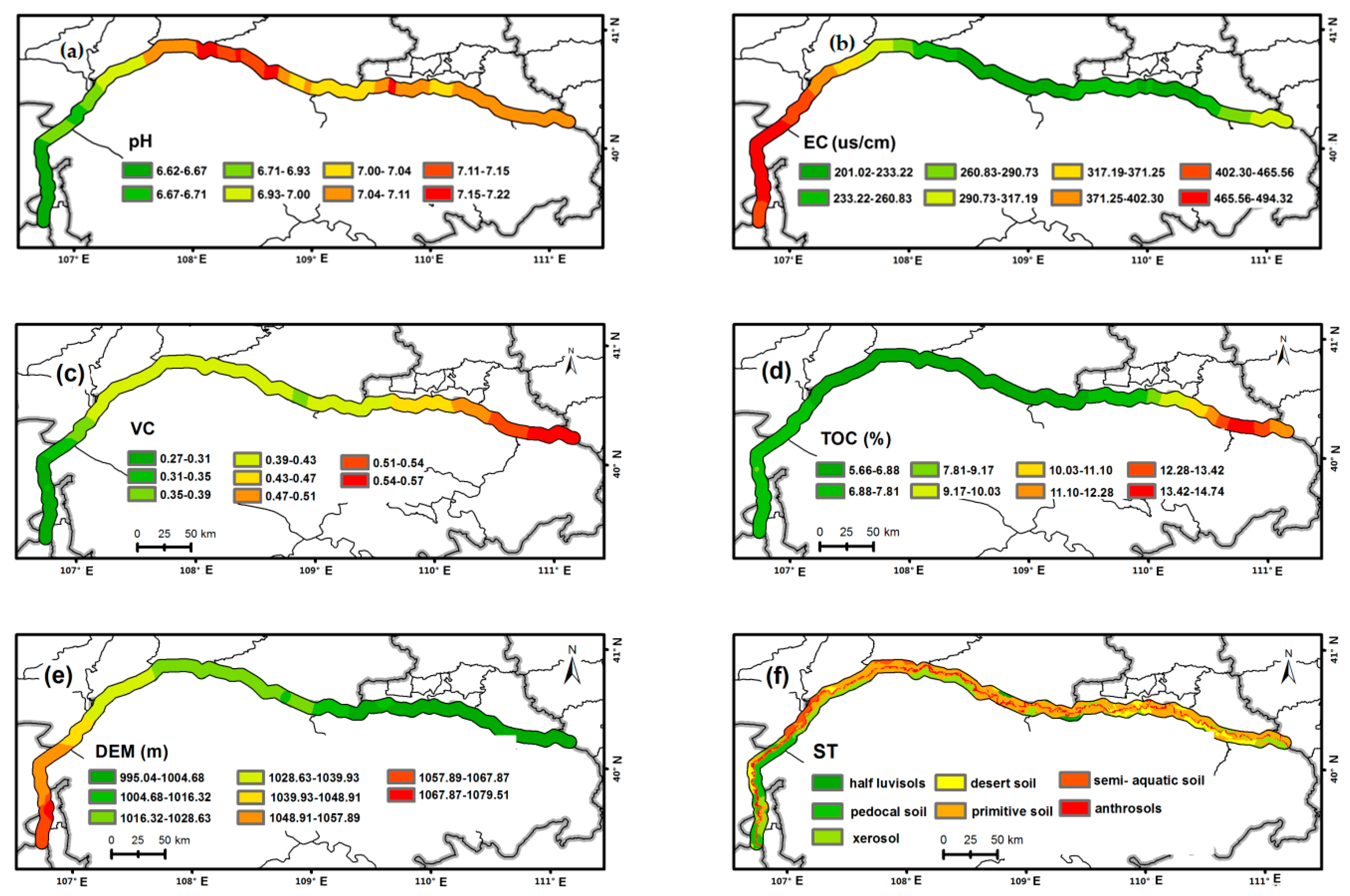
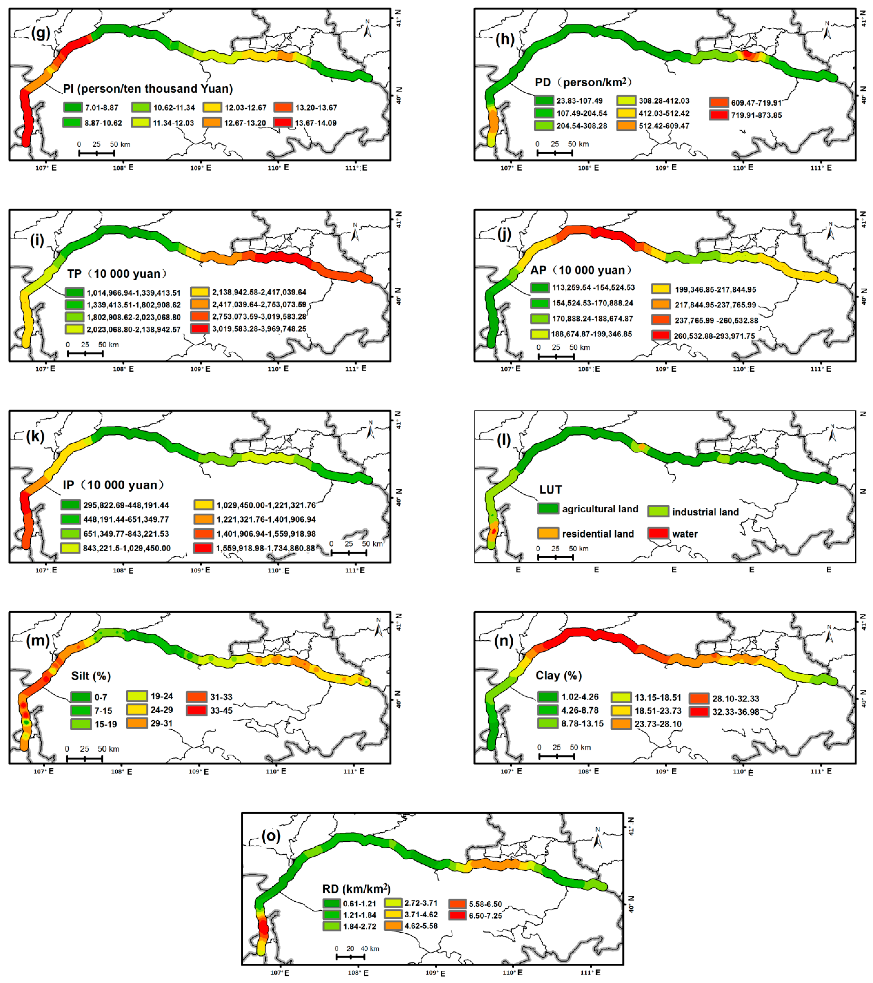
2.3. Factor Selection and Data Acquisition

Heavy metals in river sediments were derived from not only natural sources such as vegetation coverage and grain size but also human activities such as industrial and agricultural production and transportation. Considering that there is a strong positive correlation between clay particles and TOC in the sediment, only TOC was selected as the influencing factor in this study. Combining the river sediment characteristics and data availability, this study finally selected 8 natural factors, including pH, EC, vegetation coverage (VC), TOC, DEM, soil types (ST), soil clay concentration (Clay), and soil silt concentration (Silt), as well as 7 anthropogenic factors, including per capita income (PI), population density (PD), total production (TP), agricultural production (AP), industrial production (IP), land use types (LUT), and road network density (RD).
pH, EC, and TOC data of each sample site were derived from sediment measurements. DEM data were obtained from handheld GPS (Global Positioning System) determination. VC, ST, RD (including expressways, national roads, provincial roads and urban roads), Silt, and Clay data were acquired from the Data Center for Resources and Environmental Sciences (RESDC), Chinese Academy of Sciences (available online at http://www.resdc.cn, accessed on 13 April 2019), and processed and obtained by ArcGIS10.2 software (ESRI, Redlands, CA, USA). LUT was determined by field investigation and remote-sensing image data. PI, PD, TP, AP, and IP data of each county or district were acquired, calculated based on demographic data and economic data from the Inner Mongolia Statistical Yearbook 2018 [36] published by China Statistics Press, and assigned to the sediment sample sites included.

2.4. GDM

The GDM is a statistical method based on the spatial differentiation theory to detect the spatial correlation between geographical factors and influencing factors [37,38]. The three components of the GDM (factor detector, risk detector, and interaction detector) were employed in this study, and they solved the four problems mentioned earlier. Their principles are described below.
The factor detector, the core part of the GDM, can ascertain the influencing level of factors on the spatial distribution of heavy metals by   Q D , H . When the   Q D , H value is larger, the explanatory power of the factor on the spatial distribution of the heavy metal is stronger. This influencing factor is responsible for the spatial differentiation of the heavy metal. The   Q D , H is calculated as follows:
  Q D , H = 1 i m N D , i σ HD , i 2 N σ H 2
where D represents an influencing factor, H represents a sediment heavy metal, m is the number of categories of factor D , N D , i is the number of samples in the “i” category of factor D , N is the total number of samples of heavy metal H , σ HD , i 2 is the variance of the “i” category of factor D to heavy metal H , and σ H 2 is the total variance of heavy metal H .
The risk detector searches a category that is the largest average concentration of heavy metals is the high-risk category, and its distribution area is the high-risk area. A t-test was used to determine whether the difference between the categories was significant, expressed by the formula:
t H i = 1 H i = 2 = H ¯ i = 1 H ¯ i = 2 [ Var ( H ¯ i = 1 ) n i = 1 + Var ( H ¯ i = 2 ) n i = 2 ] 1 / 2  
where “ Var ” represents variance, H i is the average values of the “i” category, and n i is the number of samples of the “i” category. With the null hypothesis H 0 : H ¯ i = 1 = H ¯ i = 2 , there is a significant difference between the average values of the two categories if H 0 is rejected at a confidence level α. “Yes” in the GDM means that there is a significant difference between the two categories and “No” means contrarily.
The interaction detector is used to detect the explanatory power of the interaction between any two factors and heavy metals. By comparing the   Q D , H values of the combined and separate effects of the two factors on the heavy metals, it can ascertain whether the interaction between the two factors is enhanced or weakened when they work together or whether their influences on heavy metals are independent of each other. Five interaction types are identified:
  • Nonlinearity weakness: Q(D1 ∩ D2) < MIN(Q(D1),Q(D2));
  • Nonlinearity weakness for a single factor;
  • MIN(Q(D1),Q(D2)) < Q(D1 ∩ D2) < MAX(Q(D1),Q(D2));
  • Enhancement of nonlinearity: Q(D1 ∩ D2) > Q(D1) + Q(D2);
  • Enhancement of two factors: Q(D1 ∩ D2) > MAX(Q(D1),Q(D2));
  • Independence: Q(D1 ∩ D2) = Q(D1) + Q(D2).

2.5. Data Processing and Graphics Production

Based on ArcGIS 10.2 software, the sampling site data were interpolated by Kriging to obtain an interpolation graph. A buffer of 3 km was found on both sides of the Inner Mongolia section of the Yellow River. The interpolation graph and buffer were extracted by a mask, and the extracted result was classified. The numerical data were divided into 8 categories according to the natural grading breakpoint method, and the qualitative data was divided into actual types. Finally, the spatial distribution map was completed.
In order to meet the data requirements of the GDM, the sample sites were first dispersed to form a dot grid of 3 km × 3 km (Figure 2). Secondly, the values of each factor were extracted to discrete points. Finally, each record ( H , D ) was inputted into the GDM for detection and analysis.

3. Results and Analysis

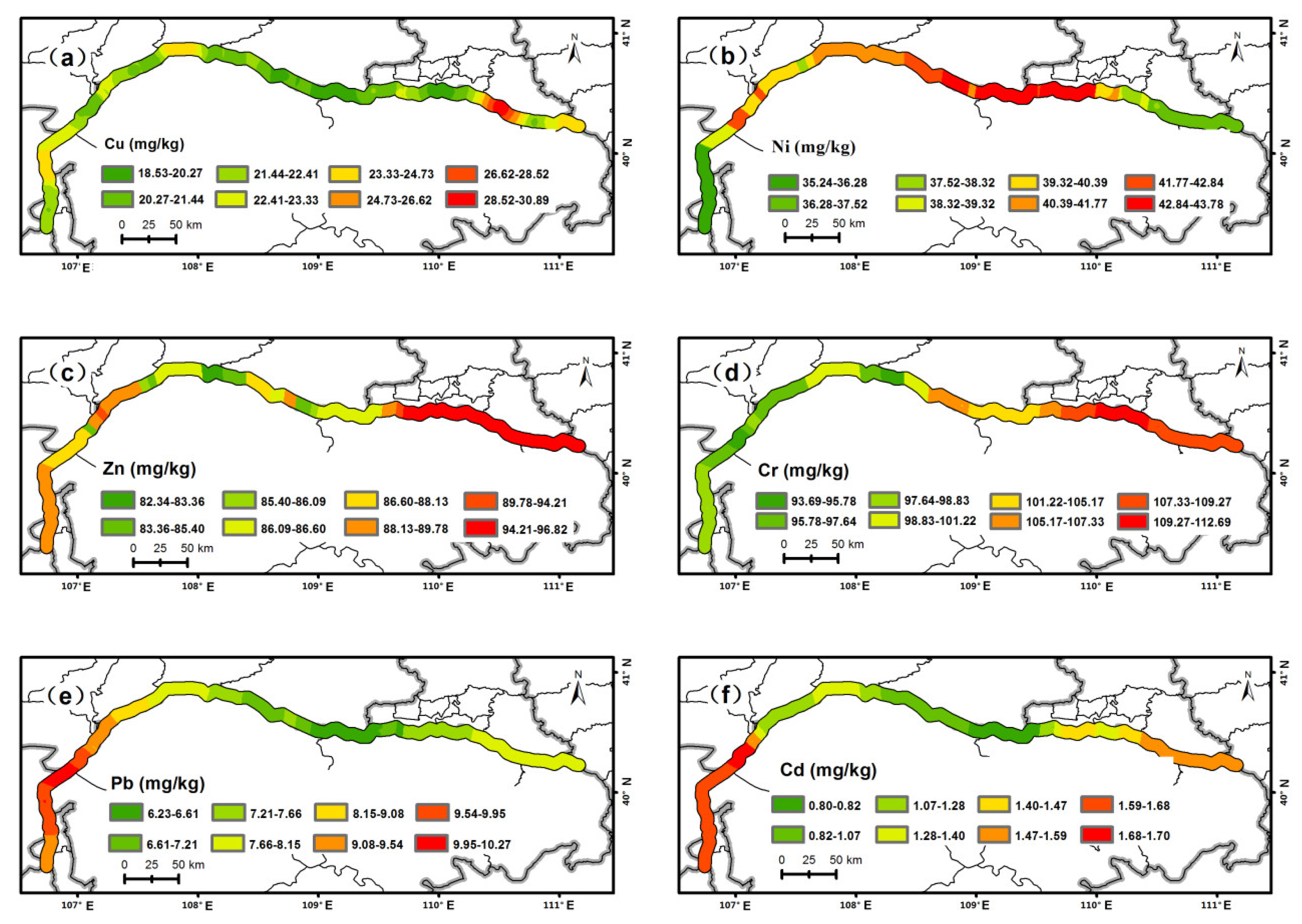
3.1. Concentrations of Heavy Metals in Sediment

Descriptive statistics of heavy metal concentrations in sediments from the Inner Mongolia section of the Yellow River are presented in Table 1. The average concentrations of Cu, Ni, Cr, Pb, and Cd, except for Zn, in the sediment of the Inner Mongolia section of the Yellow River were higher than their corresponding average values in soil, especially the average concentrations of Cr and Cu, which were 2.51 and 1.29 times their soil values (Table 1). Compared with the world average concentration in the shales [39] and the first-level standard of the soil environmental quality of China [40], only the average concentrations of Cr and Cd were higher, indicating they were greatly affected by human beings and were the main risk factors in the study area. The coefficient of variations (CVs) of Cr, Zn, and Cu ranged from 21.54% to 33.13%, which were moderate variation (15% < CV < 36%), and the CVs of the others reached high variation, indicating that all heavy metals possessed spatial differentiation. In particular, the CVs of Pb and Cd (48.16% and 82.14%, respectively) showed a larger spatial differentiation than the other heavy metals, revealing that their distributions demonstrated greater variability. Conclusions could also be obtained from their spatial distribution maps (Figure 3). The low concentration value of Cu was primary, and its high-concentration areas were only concentrated in Tumote Youqi of Baotou City. The spatial distribution pattern of the Ni concentration was “low at both ends and high in the middle,” and its high-value areas mainly appeared in Wulate Qianqi and Jiuyuan District. The high-value distributions of Zn and Cr concentrations were identical, which were displayed in Jiuyuan District, Donghe District, and Tumote Youqi of Baotou City. The spatial distribution patterns of Pb and Cd concentrations were similar, with the highest values concentrated in Wuhai City, Alashan Left Banner, and Dengkou County.

3.2. GDM Analysis

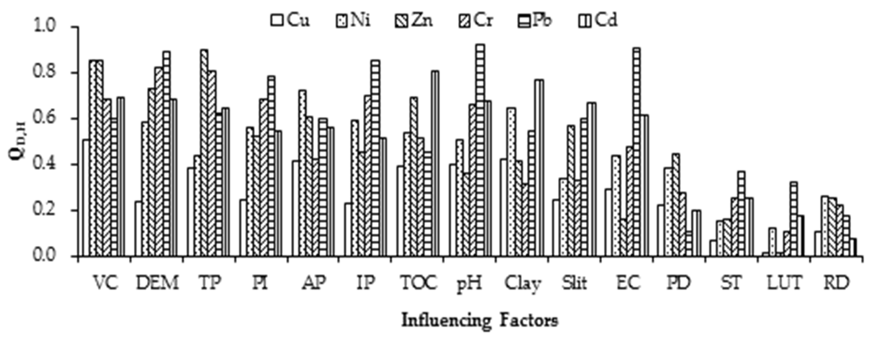
3.2.1. Detection of Key Influencing Factors and Risk Area

Key influencing factors of the spatial differentiation of each heavy metal were revealed by the factor detector, and combined with the risk detector, their risk categories and risk areas were further identified. On the whole, the explanatory powers of VC (   Q D , H > 0.50) and PI (excluding Cu, Q D , H > 0.50) for the spatial differentiation of heavy metals in sediments were greater, suggesting they were key factors of all heavy metals, whereas those of LUT (excluding Pb,   Q D , H < 0.20) and RD ( Q D , H < 0.30) were smaller (Figure 4). However, the leading factors between heavy metals were different. The explanatory power of each factor to Cu was not great among those of VC ( Q D , H = 0.51), Clay ( Q D , H = 0.42), and AP (   Q D , H = 0.41), which were higher and acted as the key influencing factors. Their risk categories were Category 8, Category 3–4, and Category 5, respectively, and their risk areas were mainly Tumote Youqi (Figure 5, Table 2). Key influencing factors of Ni were VC ( Q D , H = 0.86), AP (   Q D , H = 0.73) and Clay ( Q D , H = 0.65), which were the same as Cu. Risk categories of VC, AP, and Clay of Ni were Category 4–5, Category 8, and Category 6, respectively, and the risk areas were Wulate Qianqi and Jiuyuan District, which were different from Cu. Category 8 of TP, Category 1 of DEM, and Category 6 of VC were risk categories and key factors of Zn and Cr, and their risk areas were the same, which were all Baotou City. Key natural factors and risk categories of Pb were pH ( Q D , H = 0.92) with Category 1 and EC (   Q D , H = 0.92) with Category 8. The key anthropogenic factor was IP (   Q D , H = 0.86) with Category 7, and the risk areas were Wuhai City, Alashan Left Banner, and Dengkou County. The first key natural factor of Cd was TOC ( Q D , H = 0.81), and its risk category and risk area were Category 5–6 and Tumote Youqi, respectively. The second was Clay (   Q D , H = 0.77); its risk category was Category 1, and the risk area was Wuhathe City. The first key anthropogenic factor of Cd was TP ( Q D , H = 0.81) with a risk Category 5 and a risk area for Wuhathe City and Alashan Left Banner. The second was AP (   Q D , H = 0.57) with a risk category of Category 3 and risk area for Dengkou County.
Based on the factor detector, relatedness between heavy metals was confirmed. Cu had a small correlation with other heavy metals ( Q D , H < 0.50), whereas Cd had a large correlation with other heavy metals (   Q D , H > 0.50). In addition, the correlation between Zn and Cr, Cd, and Pb was the strongest (Figure 6).

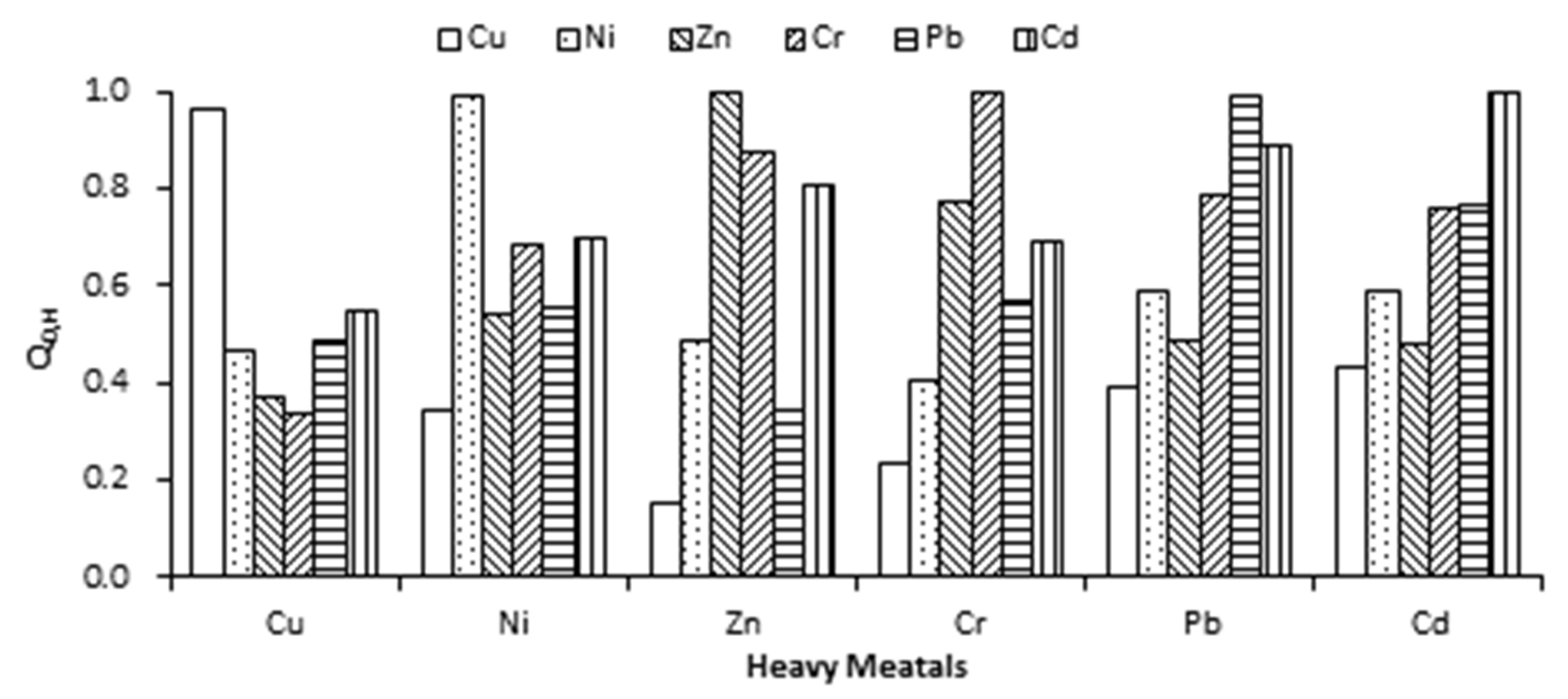
3.2.2. Detection of Interaction of Factors

By comparing the Q D , H values of the effect of double factors and a single factor on heavy metals in sediments, the interaction type of factors was ascertained for mostly the double-factor enhancement type, a few for the nonlinear enhancement type, and no independence and weakness types (Table 3). Factors of important interactions for heavy metals, except for Ni (VC ∩ PH), were all anthropogenic and natural factors, such as Cu for AP ∩ EC, Zn and Cd for TP ∩ pH, and Cr and Pb for IP ∩ pH. Single PD and RD had a small effect on heavy metals in sediments, but their interaction with other factors was mostly greater for the nonlinear enhancement type. Therefore, the contribution of PD and RD to the spatial differentiation of heavy metals could not be ignored.

4. Discussion

Key influencing factors detected by geographic detectors had important contributions to the spatial differentiation of heavy metals in sediments, but they could not be directly regarded as the main pollution sources of heavy metals. The determination of sources of heavy metals in sediments involved not only key influencing factors but also risk categories and risk area environments. The risk category of key influencing factors of heavy metals was high (category > 4) or low (category < 4), indicating that there might be a positive or negative correlation between heavy metals and this factor. If this influencing factor for the anthropogenic factor had a higher risk category, it was usually a source of heavy metal. This result needed to be further confirmed in the risk area.
The correlation between Cu and other metals was small, showing that they might not have a common source of pollution, and the source of Cu was single. The risk category of the first key influencing factor, the VC of Cu, was the highest (Category 8), suggesting that the highest concentration of Cu was located in the region with the biggest VC. High VC could slow down the speed of the water retreat of the farmland and facilitated Cu deposition to the river sediment. The risk category of the key anthropogenic factor AP was higher (Category 5), indicating that agricultural activities such as fertilization, pesticides, and livestock feeds were sources of Cu in the sediment [41,42]. Tumote Youqi, a risk area of Cu, was based on agricultural production and had a significant accumulation of Cu in the sediment [29]. Chen et al. revealed that the Cu concentration was higher when using fertilizers of Tumote Youqi [43]. These results further ascertained that the sources of Cu were agricultural activities under a high VC.
The risk categories of key natural factors such as the VC and Clay of Ni were all higher, indicating that the highest concentration of Ni was under the environment with a higher VC and Clay. The risk categories of main anthropogenic factors AP and IP were 8 and 3–4, respectively, showing that the sources of Ni were the main agricultural activities and a few for industrial emissions. However, the sources of Ni were different in risk areas Wulate Qianqi and Jiuyuan District. Sources of Ni in Wulate Qianqi, which was dominated by irrigated agriculture, were agricultural activities. This result is consistent with the findings of Guan et al. [29] and Wang [44]. Sources of Ni in Jiuyuan District dominated by industrial production were industrial emissions, which were the main sources of Ni in the soil of this region [45].
Key influencing factors and their risk categories of Zn and Cr were TP with Category 8, DEM with Category 1, and VC with Category 6, with the strongest correlation, indicating that the highest concentrations of Zn and Cr were located in the region with the highest TP, the lowest DEM, and the highest VC in the Inner Mongolia section of the Yellow River, and they might have the same or similar pollution sources. Due to TP for their first key anthropogenic factor, primary sources of Zn and Cr were production activities. Zn was mainly from agricultural production because of AP for its second key anthropogenic factor. Cr was mainly from industrial production because of IP for its second key anthropogenic factor. In addition, the risk category of DEM was the lowest, indicating that Zn and Cr might come from migration. Baotou City as a risk area of Zn and Cr is the most economically developed and the largest industrial city in the Inner Mongolia Autonomous Region, possessing a large number of mineral resources and the world’s largest Bayan Obo rare earth mine distribution. Some scholars found that the soil and road dust in Baotou City had a significant enrichment of Zn and Cr from industrial emissions [46,47,48,49]. Therefore, combined with the above results of the GDM, sources of Zn and Cr in the sediment might also come from industrial production.
The first and second influencing factors and their risk categories of Pb were pH with Category 1 and EC with Category 8, showing that the highest concentrations of Pb existed in acidic and highly saline sediments. A low pH may improve metal mobilization from terrestrial sources and their subsequent retention in river sediment [50]. High salinity (EC) can enhance the adsorption of heavy metals by the sediment [51]. The risk category of the main anthropogenic factor IP of Pb was higher (Category 7), indicating that the main source of Pb was industrial emissions. The first and second influencing factors and their risk categories of Cd were TOC with Category 5–6 and Clay with Category 1, showing that the highest concentrations of Cd were located in the river section of higher TOC sediment and low Clay in soil. TOC concentration has a positive correlation with the metal concentration [52]; therefore, a high TOC has a high concentration of Cd in the sediment. Clay is a metal carrier, and high Clay has a strong adsorption capacity to metals [53]. Many metals with low clay content in soil are liable to flowing into rivers and depositing in the sediment. TP with Category 5 risk was a key anthropogenic factor of Cd, inferring that the main sources of Cd were production activities, including agricultural and industrial production. In addition, DEM with Category 7 risk was an important factor of Pb and Cd, indicating that they might come from atmospheric deposition. Pb and Cd had the strongest correlation, indicating that they both possibly came from the same sources, which might be atmospheric deposition and industrial emissions, according to the above results. Wuhai City as a risk area of Pb and Cd possesses rich coal resources and is an important industrial city of the Inner Mongolia Autonomous Region. The exploitation and use of coal released much Pb and Cd and caused atmosphere and soil pollution in Wuhai City [54,55], which further confirmed the results of the GDM.

5. Conclusions

Based on the GDM, the influences of 15 factors on 6 heavy metals in sediments from the Inner Mongolia section of the Yellow River were analyzed, and the following conclusions were drawn:
(1)
The accumulation of Cr and Cd in the sediment of the Inner Mongolia section of the Yellow River was the most obvious, and they were the main risk metals in the study area. All heavy metals possessed spatial differentiation. Pb and Cd had a larger spatial differentiation than other heavy metals.
(2)
All 15 factors had influences on the spatial distribution of heavy metals in sediments, and VC and PI had a greater influence. The interaction types between the factors were ascertained for mostly the double-factor enhancement type, a few nonlinear enhancement type, and no independence and weakness type.
(3)
Wuhai City and Baotou City were the main risk areas in the Inner Mongolia section of the Yellow River. Wuhai City was chiefly polluted by Cd and Pb, and Baotou City was mainly polluted by Cr.
(4)
Heavy metals in the sediment of the Inner Mongolia section of the Yellow River had different sources. Cu was mainly from agricultural sources such as fertilization. Ni mainly came from agricultural production and a few from industrial emissions. Zn and Cr were derived from migration and various production activities. Pb and Cd were mainly derived from atmospheric deposition and industrial coal emissions.

Author Contributions

Conceptualization, J.R. and J.H.; methodology, J.H. and H.F.; software, J.H.; formal analysis, L.T.; investigation, J.H., H.F. and L.T.; data curation, H.F. and L.T.; writing—original draft preparation, J.H.; writing—review and editing, J.R. and J.H.; visualization, J.H. and H.F.; supervision, J.H.; funding acquisition, J.R. All authors have read and agreed to the published version of the manuscript.

Funding

This research was funded by the National Natural Science Foundation of China (Grant No. 51668034).

Institutional Review Board Statement

Not applicable.

Informed Consent Statement

Not applicable.

Data Availability Statement

No new data were created or analyzed in this study. Data sharing is not applicable to this article.

Conflicts of Interest

The authors declare no conflict of interest.

References

  1. Barletta, M.; Lima, A.R.A.; Costa, M.F. Distribution, sources and consequences of nutrients, persistent organic pollutants, metals and microplastics in South American estuaries. Sci. Total Environ. 2019, 651, 1199–1218. [Google Scholar] [CrossRef] [PubMed]
  2. Ke, X.; Gui, S.; Huang, H.; Zhang, H.; Wang, C.; Guo, W. Ecological risk assessment and source identification for heavy metals in surface sediment from the Liaohe River protected area, China. Chemosphere 2017, 175, 473–481. [Google Scholar] [CrossRef] [PubMed]
  3. Zhang, Y.; Yu, Y.; Li, S.; Zhu, Y.; Wei, W. Characteristics and ecological risk assessment of heavy metal in sediments Chao river, north China. Environ. Sci. Technol. 2020, 43, 169–179. [Google Scholar]
  4. Zhao, G.; Ye, S.; Yuan, H.; Ding, X.; Wang, J.; Laws, E.A. Surface sediment properties and heavy metal contamination assessment in river sediments of the Pearl River Delta, China. Mar. Pollut. Bull. 2018, 136, 300–308. [Google Scholar] [CrossRef] [PubMed]
  5. Xia, F.; Qu, L.; Wang, T.; Luo, L.; Chen, H.; Dahlgren, R.A.; Zhang, M.; Mei, K.; Huang, H. Distribution and source analysis of heavy metal pollutants in sediments of a rapid developing urban river system. Chemosphere 2018, 207, 218–228. [Google Scholar] [CrossRef] [PubMed] [Green Version]
  6. Vu, C.T.; Lin, C.; Shern, C.-C.; Yeh, G.; Le, V.G.; Tran, H.T. Contamination, ecological risk and source apportionment of heavy metals in sediments and water of a contaminated river in Taiwan. Ecol. Indic. 2017, 82, 32–42. [Google Scholar] [CrossRef]
  7. Zhang, Z.; Lu, Y.; Li, H.; Tu, Y.; Liu, B.; Yang, Z. Assessment of heavy metal contamination, distribution and source identification in the sediments from the Zijiang River, China. Sci. Total Environ. 2018, 645, 235–243. [Google Scholar] [CrossRef]
  8. Chen, H.; Teng, Y.; Li, J.; Wu, J.; Wang, J. Source apportionment of trace metals in river sediments: A comparison of three methods. Environ. Pollut. 2016, 211, 28–37. [Google Scholar] [CrossRef]
  9. Zhuang, Q.; Li, G.; Liu, Z. Distribution, source and pollution level of heavy metals in river sediments from South China. Catena 2018, 170, 386–396. [Google Scholar] [CrossRef]
  10. Shui, L.; Pan, X.; Chen, X.; Chang, F.; Wan, D.; Liu, D.; Hu, M.; Li, S.; Wang, Y. Pollution Characteristics and Ecological Risk Assessment of Heavy Metals in Sediments of the Three Gorges Reservoir. Water 2020, 12, 1798. [Google Scholar] [CrossRef]
  11. El Zrelli, R.; Courjault-Rade, P.; Rabaoui, L.; Castet, S.; Michel, S.; Bejaoui, N. Heavy metal contamination and ecological risk assessment in the surface sediments of the coastal area surrounding the industrial complex of Gabes city, Gulf of Gabes, SE Tunisia. Mar. Pollut. Bull. 2015, 101, 922–929. [Google Scholar] [CrossRef] [PubMed]
  12. Han, D.; Cheng, J.; Hu, X.; Jiang, Z.; Mo, L.; Xu, H.; Ma, Y.; Chen, X.; Wang, H. Spatial distribution, risk assessment and source identification of heavy metals in sediments of the Yangtze River Estuary, China. Mar. Pollut. Bull. 2017, 115, 141–148. [Google Scholar] [CrossRef] [PubMed]
  13. Arfaeinia, H.; Dobaradaran, S.; Moradi, M.; Pasalari, H.; Mehrizi, E.A.; Taghizadeh, F.; Esmaili, A.; Ansarizadeh, M. The effect of land use configurations on concentration, spatial distribution, and ecological risk of heavy metals in coastal sediments of northern part along the Persian Gulf. Sci. Total Environ. 2019, 653, 783–791. [Google Scholar] [CrossRef] [PubMed]
  14. Goldyn, B.; Chudzinska, M.; Baralkiewicz, D.; Celewicz-Goldyn, S. Heavy metal contents in the sediments of astatic ponds: Influence of geomorphology, hydroperiod, water chemistry and vegetation. Ecotoxicol. Environ. Saf. 2015, 118, 103–111. [Google Scholar] [CrossRef]
  15. Zang, F.; Wang, S.; Nan, Z.; Ma, J.; Wang, Y.; Chen, Y.; Zhang, Q.; Li, Y. Influence of pH on the release and chemical fractionation of heavy metals in sediment from a suburban drainage stream in an arid mine-based oasis. J. Soils Sediments 2017, 17, 2524–2536. [Google Scholar] [CrossRef]
  16. Shi, C.; Ding, H.; Zan, Q.; Li, R. Spatial variation and ecological risk assessment of heavy metals in mangrove sediments across China. Mar. Pollut. Bull. 2019, 143, 115–124. [Google Scholar] [CrossRef]
  17. Jahan, S.; Strezov, V. Comparison of pollution indices for the assessment of heavy metals in the sediments of seaports of NSW, Australia. Mar. Pollut. Bull. 2018, 128, 295–306. [Google Scholar] [CrossRef]
  18. Wang, L.; Zeng, X.; Duan, C.; Yu, H.; Yang, M. Analysis on influencing factors of heavy metal pollution in sediments of Poyang Lake based on STIRPAT Model. China Environ. Sci. 2020, 40, 3683–3692. [Google Scholar]
  19. Wu, Q.; Qi, J.; Xia, X. Long-term variations in sediment heavy metals of a reservoir with changing trophic states: Implications for the impact of climate change. Sci. Total Environ. 2017, 609, 242–250. [Google Scholar] [CrossRef] [PubMed]
  20. Zhu, L.; Liu, J.; Xu, S.; Xie, Z. Deposition behavior, risk assessment and source identification of heavy metals in reservoir sediments of Northeast China. Ecotoxicol. Environ. Saf. 2017, 142, 454–463. [Google Scholar] [CrossRef] [PubMed]
  21. Aguilar Pesantes, A.; Peña Carpio, E.; Vitvar, T.; María Mahamud López, M.; Menéndez-Aguado, J.M. A Multi-Index Analysis Approach to Heavy Metal Pollution Assessment in River Sediments in the Ponce Enríquez Area, Ecuador. Water 2019, 11, 590. [Google Scholar] [CrossRef] [Green Version]
  22. Wang, J.; Li, X.; Christakos, G.; Liao, Y.; Zhang, T.; Gu, X.; Zheng, X.Y. Geographical detectors-based health risk assessment and its application in the neural tube defects study of the Heshun Region, China. Int. J. Geogr. Inf. Sci. 2010, 24, 107–127. [Google Scholar] [CrossRef]
  23. Qiao, P.; Yang, S.; Lei, M.; Chen, T.; Dong, N. Quantitative analysis of the factors influencing spatial distribution of soil heavy metals based on geographical detector. Sci. Total Environ. 2019, 664, 392–413. [Google Scholar] [CrossRef]
  24. Wang, B.; Yang, T. Evaluation and driving force analysis of ecosystem service value in Yinchuan City from 1980 to 2018. Arid Land Geogr. 2021, 44, 552–564. [Google Scholar]
  25. Miao, X.; Liang, Q. Spatial differentiation of county economic development level and its influencing factors in Zhejiang Province based on geographical detector. J. Zhejiang Norm. Univ. 2020, 43, 460–467. [Google Scholar]
  26. Jia, L.; Yao, S.; Deng, Y.; Li, Y.; Hou, M.; Gong, Z. Spatial and temporal characteristics of soil erosion and its geographical detection in the Weihe River Basin. J. Ecol. Rural Environ. 2021, 37, 305–314. [Google Scholar]
  27. Yin, L.; Feng, X.; Fu, B.; Wang, S.; Wang, X.; Chen, Y.; Tao, F.; Hu, J. A coupled human-natural system analysis of water yield in the Yellow River basin, China. Sci. Total Environ. 2021, 762, 143141. [Google Scholar] [CrossRef] [PubMed]
  28. Ren, J.; Hao, J.; Tao, L. Concentrations, spatial distribution, and pollution assessment of heavy metals in surficial sediments from upstream of Yellow River, China. Environ. Sci. Pollut. Res. Int. 2021, 28, 2904–2913. [Google Scholar] [CrossRef] [PubMed]
  29. Guan, Q.; Wang, L.; Pan, B.; Guan, W.; Sun, X.; Cai, A. Distribution features and controls of heavy metals in surface sediments from the riverbed of the Ningxia-Inner Mongolian reaches, Yellow River, China. Chemosphere 2016, 144, 29–42. [Google Scholar] [CrossRef] [PubMed]
  30. Rao, Q.; Sun, Z.; Tian, L.; Li, J.; Sun, W.; Sun, W. Assessment of arsenic and heavy metal pollution and ecological risk in inshore sediments of the Yellow River estuary, China. Stoch. Environ. Res. Risk Assess. 2018, 32, 2889–2902. [Google Scholar] [CrossRef]
  31. Lu, J.; Ma, L. Analysis of water demand for channel forming and sediment transport in the Upper Reaches of the Yellow River in Inner Mongolia. Trans. Chin. Soc. Agric. Eng. 2020, 36, 123–128. [Google Scholar]
  32. Wang, X.; Qi, L. Bacterial diversity and community structure types in surface sediments of Inner Mongolia section of the Yellow River. Acta Ecol. Sin. 2020, 40, 578–589. [Google Scholar]
  33. Hu, C.; Ma, Y.; Guo, C.; Li, D.; Pei, Q. Optimization of the experiment conditions for estimating organic matter content with Loss-on-ignition Method. Earth Environ. 2016, 44, 110–118. [Google Scholar]
  34. Wang, X.; Zhang, Y.; Huang, B.; Xie, E.; Fan, W.; Hu, W.; Zhao, Y. Accumulation and sources of heavy metals in agricultural soil in a city typical of the Yangtze River Delta, China. Acta Pedol. Sin. 2021, 58, 82–90. [Google Scholar]
  35. Huang, L.; Zhang, H.; Lao, L.; Li, S.; Jie, Z. Research progress of electrical conductivity in soil salt detection. Low Temp. Archit. Technol. 2018, 40, 77–91. [Google Scholar]
  36. Inner Mongolia Statistical Bureau. Inner Mongolia Statistical Yearbook 2018; China Statistic Press: Beijing, China, 2018.
  37. Zhao, Y.; Deng, Q.; Lin, Q.; Zeng, C.; Zhong, C. Cadmium source identification in soils and high-risk regions predicted by geographical detector method. Environ. Pollut. 2020, 263, 114338. [Google Scholar] [CrossRef]
  38. Wang, J.; Xu, C. Geodetector: Principle and prospective. Acta Geogr. Sin. 2017, 72, 116–334. [Google Scholar]
  39. Turekian, K.; Wedepohl, K. Distribution of the elements in some major units of the earth’s crust. Geol. Soc. Am. Bull. 1961, 72, 175–192. [Google Scholar] [CrossRef]
  40. The State Environmental Protection Administration (SEPA). The National Standard of Soil Environmental Quality Standard of the People’s Republic of China (GB15618-1995); The People’s Republic of China State Environmental Protection Agency: Beijing, China, 1995.
  41. Marrugo-Negrete, J.; Pinedo-Hernández, J.; Díez, S. Assessment of heavy metal pollution, spatial distribution and origin in agricultural soils along the Sinú River basin, Colombia. Environ. Res. 2017, 154, 380–388. [Google Scholar] [CrossRef] [PubMed]
  42. Lu, A.; Wang, J.; Qin, X.; Wang, K.; Han, P.; Zhang, S. Multivariate and geostatistical analyses of the spatial distribution and origin of heavy metals in the agricultural soils in Shunyi, Beijing, China. Sci. Total Environ. 2012, 425, 66–74. [Google Scholar] [CrossRef]
  43. Chen, L.; Ni, W.; Li, X.; Sun, B. Investigation and analysis of heavy metal content in common fertilizer. J. Zhejiang Sci-Tech Univ. 2009, 26, 223–227. [Google Scholar]
  44. Wang, L. Spatial Variation and Causal Factors of Heavy Metals and Phosphorus in Surface Sediment from the Catchment of the Ningxia-Inner Mongolian Reaches, Yellow River. Ph.D. Thesis, Lanzhou University, Lanzhou, China, July 2016. [Google Scholar]
  45. Sun, P.; Li, Y.; Zhang, L.; Li, Y.; Wang, W.; Yu, W. Heavy metal pollution in topsoil from the baotou industry area and its potential ecological risk evaluation. Rock Miner. Anal. 2016, 35, 433–439. [Google Scholar]
  46. Han, X. Pollution of Heavy Metals and Polycyclic Aromatic Hydrocarbons in Surface Dust of Baotou City. Ph.D. Thesis, Shanxi Normal University, Xi’an, China, November 2019. [Google Scholar]
  47. Shi, D.; Lu, X.; Xu, X.; Han, X. Study on pollution and source of heavy metals in the re-suspended road dust from baotou urban area, China. Environ. Sci. Technol. 2019, 42, 16–23. [Google Scholar]
  48. Pan, Y.; Li, H. Investigating Heavy Metal Pollution in Mining Brownfield and Its Policy Implications: A Case Study of the Bayan Obo Rare Earth Mine, Inner Mongolia, China. Environ. Manag. 2016, 57, 879–893. [Google Scholar] [CrossRef] [PubMed]
  49. Li, K.; Liang, T.; Wang, L.; Yang, Z. Contamination and health risk assessment of heavy metals in road dust in Bayan Obo Mining Region in Inner Mongolia, North China. J. Geogr. Sci. 2015, 25, 1439–1451. [Google Scholar] [CrossRef] [Green Version]
  50. Luo, L.; Mei, K.; Qu, L.; Zhang, C.; Chen, H.; Wang, S.; Di, D.; Huang, H.; Wang, Z.; Xia, F.; et al. Assessment of the Geographical Detector Method for investigating heavy metal source apportionment in an urban watershed of Eastern China. Sci. Total Environ. 2019, 653, 714–722. [Google Scholar] [CrossRef] [PubMed] [Green Version]
  51. Bai, J.; Zhao, Q.; Lu, Q.; Wang, J.; Reddy, K.R. Effects of freshwater input on trace element pollution in salt marsh soils of a typical coastal estuary, China. J. Hydrol. 2015, 520, 186–192. [Google Scholar] [CrossRef]
  52. Ünlü, S.; Alpar, B. An assessment of metal contamination in the shelf sediments at the southern exit of Bosphorus Strait, Turkey. Toxicol. Environ. Chem. 2015, 97, 723–740. [Google Scholar] [CrossRef]
  53. Gan, H.; Lin, J.; Liang, K.; Xia, Z. Selected trace metals (As, Cd and Hg) distribution and contamination in the coastal wetland sediment of the northern Beibu Gulf, South China Sea. Mar. Pollut. Bull. 2013, 66, 252–258. [Google Scholar] [CrossRef]
  54. Wu, H.; Shi, C.; Zhang, Y.; Zhao, T.; Hu, P.; Liu, Y.; Chen, T. Characteristics and Source Apportionment of Dustfall Pollution in the Coal Mine Area and Surrounding Areas of Wuhai City in Spring. Huan Jing Ke Xue Huanjing Kexue 2020, 41, 1167–1175. [Google Scholar]
  55. Bu, Q.; Li, Q.; Zhang, H.; Cao, H.; Cao, Y. Concentrations, Spatial Distributions, and Sources of Heavy Metals in Surface Soils of the Coal Mining City Wuhai, China. J. Chem. 2020, 2020. Available online: http://new66.net/s/S8SKGS (accessed on 1 January 2020). [CrossRef]
Figure 1. Spatial distribution of sampling sites in sediments from Inner Mongolia section of Yellow River.
Water 13 01103 g001
Figure 2. Distribution of discrete points in Inner Mongolia section of the Yellow River.
Water 13 01103 g002
Figure 3. Spatial Distribution of sediment heavy metal (a) Cu, (b) Ni, (c) Zn, (d) Cr, (e) Pb, and (f) Cd in Inner Mongolia section of the Yellow River.
Water 13 01103 g003
Figure 4. Influences of different factors on the explanatory power of sediment heavy metals with Q D , H value in the Inner Mongolia section of the Yellow River.
Water 13 01103 g004
Figure 5. Spatial distribution of heavy metal influencing factor (a) pH, (b) EC, (c) VC, (d) TOC, (e) DEM, (f) ST, (g) PI, (h) PD, (i) TP, (j) AP, (k) IP, (l) LUT, (m) Silt, (n) Clay, and (o) RD in sediment of Inner Mongolia section of Yellow River.
Water 13 01103 g005aWater 13 01103 g005b
Figure 6. Comparisons of explanatory power between heavy metals in sediment of Inner Mongolia section of Yellow River.
Water 13 01103 g006
Table 1. Statistic characteristics of heavy metals in sediments from Inner Mongolia section of Yellow River and refences (sample numbers = 37; unit: mg/kg).
CharacteristicCuNiZnCrPbCdReferences
Min10.288.5260.9365.690.500.23This study
Max45.5467.39149.40149.6719.984.36This study
Average22.4738.8989.70101.878.161.38This study
SD7.4514.8319.8921.953.931.13This study
CV (%)33.1338.1322.1821.5448.1682.14This study
Average Value in Soil 117.4231.91142.3040.537.451.21This study
World Average Concentration in Shales 45689590200.3Turekian and Wedepohl [39]
Grade I of Soil in China354010090350.20The State Environmental Protection Administration (SEPA) [40]
1 calculated by heavy metal mean in soil of river bank of Inner Mongolia section.
Table 2. Influencing factors and risk detection results of heavy metals in the sediment of the Inner Mongolia section of the Yellow River.
Element Explanatory Power Order
12345
CuInfluencing FactorVCClayAPpHTOC
Q D , H Value 0.510.420.410.400.39
Risk Category83–4567–8
Risk AreaTumote Dengkou; Tumote Tumote Tumote; WuyuanTumote
NiInfluencing FactorVCAPClayIPDEM
Q D , H Value 0.860.730.650.590.59
Risk Category4–5863–43
Risk AreaByan Nur; Jiuyuan Wulate; WuyuanWulate; JiuyuanWulate; JiuyuanWulate
ZnInfluencing FactorTPVCDEMTOCAP
Q D , H Value 0.900.860.740.690.61
Risk Category86173
Risk AreaBaotouDongheBaotouTumoteJiuyuan
CrInfluencing FactorDEMTPIPVCPI
Q D , H Value 0.830.810.710.690.69
Risk Category183–46–75
Risk AreaBaotouBaotouJiuyua; Donghe Donghe; Tumote Jiuyuan
PbInfluencing FactorpHECDEMIPPI
Q D , H Value 0.920.920.900.860.78
Risk Category18778
Risk AreaWuhai; AlxaWuhai; Alxa; DengkouWuhaiWuhaiWuhai; Alxa; Linhe
CdInfluencing FactorTOCClayVCDEMpH
Q D , H Value 0.810.770.690.690.68
Risk Category5–611–271
Risk AreaWulateWuhai Wuhai; AlxaWuhaiWuhai; Alxa
Table 3. Interaction of spatial differentiation risk factors of heavy metals in sediments from the Inner Mongolia section of the Yellow River.
Interaction LevelQ (D1 ∩ D2)Q (D1) + Q(D2)Interaction Type
CufirstAP ∩ EC (0.8886)0.4116 + 0.3928 = 0.8044enhancement of nonlinearity
secondAP ∩ VC (0.8250)0.4116 + 0.5058 = 0.9174enhancement of two factors
NifirstVC ∩ pH (0.9720)0.8603 + 0.5127 = 1.3730enhancement of two factors
secondVC ∩ AP (0.9633)0.8603 + 0.7282 = 1.5885enhancement of two factors
ZnfirstTP ∩ pH (0.9845)0.9030 + 0.3626 = 1.2656enhancement of two factors
secondTP ∩ VC (0.9562)0.9030 + 0.8591 = 1.7621enhancement of two factors
CrfirstIP ∩ pH (0.9968)0.7066 + 0.6643 = 1.3709enhancement of two factors
secondTP ∩ pH (0.9847)0.8090 + 0.6643 = 1.4733enhancement of two factors
PbfirstIP ∩ pH (0.9872)0.8551 + 0.9240 = 1.7791enhancement of two factors
secondIP ∩ PI (0.9815)0.8551 + 0.7844 = 1.6395enhancement of two factors
CdfirstTP ∩ pH (0.9987)0.6458 + 0.6819 = 1.3277enhancement of two factors
secondTP ∩ PI (0.9915)0.6456 + 0.5452 = 1.1908enhancement of two factors
Publisher’s Note: MDPI stays neutral with regard to jurisdictional claims in published maps and institutional affiliations.

