Abstract
The Andes are defined by human struggles to provide for, and control, water. Nowhere is this challenge more apparent than in the unglaciated western mountain range Cordillera Negra of the Andes where rain runoff provides the only natural source of water for herding and farming economies. Based on over 20 years of systematic field surveys and taking a political ecology and resilience theory focus, this article evaluates how the Prehispanic North-Central highlands Huaylas ethnic group transformed the landscape of the Andes through the largescale construction of complex hydraulic engineering works in the Cordillera Negra of the Ancash Province, North-Central Peru. It is likely that construction of these engineered landscapes commenced during the Middle Horizon (AD 600–1000), reaching their apogee under the Late Intermediate Period (Huaylas group, AD 1000–1450) and Inca (AD 1450–1532) period, before falling into disuse during the early Spanish colony (AD 1532–1615) through a combination of disease, depopulation, and disruption. Persistent water stress in the western Pacific-facing Andean cordillera was ameliorated through the construction of interlinked dams and reservoirs controlling the water, soil, and wetlands. The modern study of these systems provides useful case-studies for infrastructure rehabilitation potentially providing low-cost, though technologically complex, solutions to modern water security.
1. Introduction
Water is a critical human resource, and cultural transformations in the Prehispanic South American Andes have been defined by how they have managed and harnessed it [1,2,3]. Nowhere is the need to control this resource more evident than along the drier western Pacific-facing Andean mountain-range [4]. Here, aside from the Cordillera la Viuda in central Peru [5], the whole of the mountain range is bereft of glacial ice cover and therefore relies exclusively on seasonal rainfall and winter sea-fog (garúa) for hydrological replenishment. Furthermore, yearly precipitation in the Cordillera Negra is half (c. 500 mm) of the average levels for the nearby ice-capped Cordillera Blanca (c. 1000 mm) [6]. Therefore, the Cordillera Negra not only does not benefit from glacier runoff but is also considerably drier than the other mountain ranges in the region.
In this article, I study the Ancash highlands of the north-central Andes focusing primarily on the Late Intermediate Period (AD 1000–1400) and the Huaylas ethnic group that inhabited this mountain range. As one of a large number of balkanized ethnic groups following the demise of the Middle Horizon (AD 600–1000) Wari in the central Andean highlands [7], the Huaylas constituted a very loosely bonded cultural unit with a common language, economy, set of beliefs (ancestor worship and especially water cult), and material culture.
In the latter case, the Huaylas shared a crude ceramic style, known generically as Aquilpo [8], with other neighboring ethnic groups to the north and south of the Ancash region. Practicing a highly specialized form of late Prehispanic agropastoralism [9], the Huaylas settled the area roughly bounded by the Cordillera Negra to the west, Cordillera Blanca to the east, the Central Andean Huayhuash Cordillera to the South and the Cañon del Pato and Santa Valley to the North [10], during the period immediately preceding the Inca expansion into the area.
Against a backdrop of a long highland drought [2] followed by fluctuating climate and water availability [11] for the 500 years following c. AD 1000 in the Andes, and taking an explicitly political ecology approach [12,13], this article analyses how the Huaylas generated societal resilience through large-scale landscape transformation. This involved the wholesale construction of dams, reservoirs, artificially irrigated wetlands, terraces, canals, and other hydraulic infrastructure, which, in turn, converted this otherwise marginal landscape into a highly productive zone able to sustain substantial human populations.
Landscape transformation and water availability were generally generated through the construction of reservoirs and dams towards water storage both physically and geologically [14]. Although scholars [15,16] have previously argued that the available evidence indicates that dams and reservoirs (represas, reservorios, and estanques) were not a major hydrological feature of either Prehispanic water storage or water flow regulation in the Andes, this has recently been revised given the overwhelming evidence for these features across large swathes of the central Andes, e.g., [17,18,19,20,21], with their use extending into Northwest Argentina [22].
That this use of technology provided the wherewithal for large local populations is attested by the large number of Late Intermediate Period settlements in the area. Perhaps surprisingly, this intricately constructed landscape was instigated and maintained by the Huaylas at a community and village level (respectively the ayllu and llacta) without obvious elite or state interference contrario sensu stricto [23], see also [24].
Incorporation into the Inca Empire brought with it state-sanctioned modifications to the hydraulic system without overtly affecting the underlying economic lifestyle and societal rationale of the Huaylas, beyond a shift to greater internal social hierarchy, including the possible Inca appointment of hereditary curaca or chiefs, such as Huacachillac Apu, Lord of the Huaylas [25]. Nevertheless, given the mountainous and often inaccessible nature of the central Andean highlands, small-holder farming has persisted and is still a way of life throughout the region [26,27,28]. In such cases, water management, as in the past, tends to still be organized at the community level [29].
Here, I evaluate the Huaylas landscape and hydraulic transformation in the Cordillera Negra as an important proxy for how community-based societies during the Late Intermediate Period in the Andes actively modified their environment providing the means for successful exploitation of the local ecology, especially water, under the aegis of a vibrant agropastoralist political economy [30], thus, leading to increased water security for these Prehispanic populations. In turn, these segmented acephalous ethnic groups were the backbone of Late Intermediate Period highland society and represented the constituent blocks of the later Inca and their eponymous empire.
In turn, I use this Huaylas case-study as a proxy for how technologically savvy groups can harness hydrological resources to provide resilience and water security under climate stress. Taking this comparison further, we advocate that Huaylas, and late Inca, landscape transformation and integrated approach to water management during the Prehispanic Period provides a potential model towards a modern best-practice use of available water resources, especially in a time of renewed hydraulic demand and deteriorating climatic conditions.
1.1. Climate and Community during the LATE Intermediate Period
The Middle Horizon (AD 600–1000), the period immediately prior to the Late Intermediate Period (AD 1000–1400), in the highlands was characterized by a long cycle of higher than average precipitation [11] and with it a concomitant cultural effervescence seen in the emergence of large consolidated cultural entities, such as the Central Andean Tiwanaku [31] and Wari polities [32]. These subsequently collapsed during the eleventh and twelfth century ushering in a period of balkanized highland communities [7].
While interpretations based around deteriorating climatic conditions are fraught with difficulties [33], nevertheless, climate post-AD 1000 took a definite turn for the worst. A recently published article shows that drought conditions in the Southern Andean highlands commenced in the mid-tenth century with arid condition extending into the thirteenth century [34], see also [35,36] for pertinent revisions of Arnold et al.’s article. It is during the Late Intermediate Period that we have the start of the warmer Medieval Climate Anomaly (MCA) dated at between ~1050 and ~1300 AD followed by a highly unstable phase leading to the onset of the Little Ice Age (LIA) ~1400 AD [37,38].
Variations on this theme see the LIA starting somewhat later at ~1500 A.D., although this is based solely on the Quellcaya data whose results are skewed by the Amazon Basin signal [39]. Nevertheless, the various authors coincide that there is a warmer, drier period during the early LIP followed by a long period of unsettled climatic conditions before the advent of colder, wetter conditions towards the end of the LIP [11,40]. These broad conclusions are also lent support by proxy data from sedimentary δ18Ocal levels taken at Laguna Pumacocha located in the eastern Central Andes, which suggests that the period between AD 900–1100, during the MCA, was particularly arid, whilst the late phase between AD 1400–1820, during the LIA, was very wet [41].
Therefore, the paleo-environmental evidence would suggest that, although the agricultural frontier might have benefitted from the warmer conditions prevalent during the eleventh to early fourteenth century, the increased aridity would likely have necessitated a greater investment in water procurement technology. In turn, this might have been a prime motivator behind increased terrace construction during and after the Middle Horizon [42] as well as potentially, investments in wetland management [43].
It is possible that rural communities at this stage gravitated around the use of an Andean highland resource suite involving maize (and potatoes) combined with domesticated camelid exploitation concentrated on the intermediate kichwa/suni (2300–4100 m) ecozones [44]. While it is likely that this agropastoralist economic package had a long pedigree [45], the increasingly specialized agropastoralism enhanced through recourse to hydraulic engineering was most likely a late Middle Horizon and Early Intermediate Period innovation.
The unsettled climatic conditions that pervaded throughout most of the Late Intermediate Period might have favored an increase in pastoralism given the mobile nature and environmental threshold tolerance of camelid vis-à-vis individual plant species. Likewise, this possibly led to increasing herder predominance within these bimodal, segmentary agropastoralist communities, e.g., [46,47].
Needless to say, segmentary social organization is very prevalent in herder-dominated societies both in the Andes and elsewhere [48,49], lending support to the idea that Late Intermediate Period segmentary organization may well have had its roots in the increasing importance of herding and herder society during this period [50]. Similarly, scholars have noted the segmentary organization prevalent in community anarchism as a potential viable model for understanding past Andean kin-group and village organization [51]. This type of organization has also been described as ‘ordered anarchy’ [52] and describes an acephalous political structure without clearly defined leaders or rulers.
In this regard, the Cordillera Negra Huaylas population of the Late Intermediate Period combined a remarkable number of hydrological technologies, which included dams, reservoirs, canals, and irrigated terraces with a patent lack of internal socio-political hierarchy. Ethnohistoric evidence [53,54] for Huaylas hierarchical social organization is likely a reflection of later social changes under Inca and Spanish hegemony, rather than the state of affairs during much of the Late Intermediate Period. Instead of institutionalized elites for the Huaylas we have a much more fluid situation in which few chiefs are born into power, rather there was a favoring of transient leadership with political power vested in the existing corporate lineage groups otherwise known as the ayllu.
Indeed, two types of authority seem to have existed throughout the Andean highlands, and among the Huaylas, at this time; authority-in-death by which important personages in life, once dead became venerated kin known as mallqui [55] with influence over day-to-day actions, and that of religio-technical authorities, such as water adjudicators, otherwise known as cilquiua [56] or water camayuc or cochacamayuc [57]. Similar to the modern varayoc or alcalde de agua (water mayor) [58,59,60,61], these individuals or specialized groups were responsible for the equitable distribution of water, as well as maintenance of the existing hydrological infrastructure through recourse to community faenas or labor, known generically as the minka, which included terrace upkeep, the dredging of reservoirs, and canal cleaning among others [24].
For the Late Intermediate Period, it was usually the herders within these agropastoralist communities who exercised the greater political control, and potentially control over water resources [62,63]. This pre-eminence of herder groups is well documented for the area of the central Andes 47, where subservient lower yunga (500–2300 m) populations were inducted into repairing the high-altitude dams controlled by the agro-pastoralist kichwa/suni (2300–4100) and puna (4100–4800) dwellers. As such, these agro-pastoralists were followers or ‘sons’ of the Andean thunder-God, purveyor of water, fertility, and animals.
Consequently, irrigation water for use in farming by lower-lying agriculturalists was often dependent upon alliances and bargaining with the herder component of these unequal, moiety-organized agro-pastoralist societies. In the study area, crucial water storage infrastructure, including dams and anthropogenically altered wetlands, were located within the herding specialized uplands. Furthermore, extant evidence shows that within these Late Intermediate Period landscapes, herder economies where not just restricted to the puna ecozone but vied, depending on climate, environmental and landscape conditions, with agriculture to extend the pastoralist boundary altitudinally downwards to cover a large chunk of the agricultural suni (3500–4100) ecozone, this served to increase the available pasturage in certain areas by as much as 50% [64].
1.2. Survey and the Study Area
The research area lies between 89°77′ to 90°04′ North and 171°70′ to 171°81′ within the Cordillera Negra, in the Ancash Province of Peru (Figure 1). Here, the Cordillera Negra mountain-range reaches a maximum height of c. 5200 m. More specifically, the research area encompasses part of the northern section of the Cordillera Negra bounded by the Chaclancayo River in the south and the Uchpacancha River to the north, comprising the Pamparomás watershed, centered on the eponymous town.
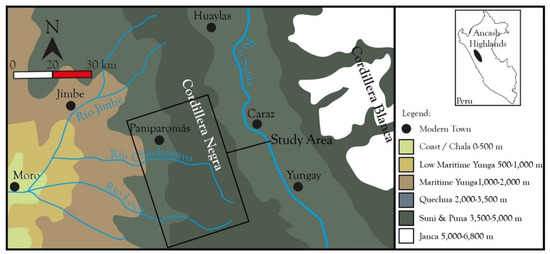
Figure 1.
Map of the study area.
The eastern peaks of the Cordillera Negra divide this area from the north–south running intermontane Santa Valley, forming the eastern boundary of our study region. Towards the west the limit of the area of research is set at 2300 m, the altitudinal division between the yunga and kichwa eco-zones. Downstream, both these highland rivers join the Colcap and Loco rivers to form the coastal Nepeña River down to the Pacific.
Geologically the upper Cordillera Negra is composed of Tertiary Volcanic Calipuy formations interspersed with pockets of earlier Cretacian geology, such as the Inca, Chulec, and Pariahuanca/Pariatambo formations; these are mainly solid Andesite conglomerates that are known for their hard though brittle nature (Figure 2). The predominance of Andesite in this cordillera makes for a rock-type with low permeability averaging 10–20 m [2,65], which permits the formation of substantial natural water basins or lakes; the fracturing of the brittle Andesite in turn generates a higher degree of permeability through crack porosity of the rock. Fresh Andesite has an 8% porosity, while weathered Andesite has porosity between 10–20% [66].
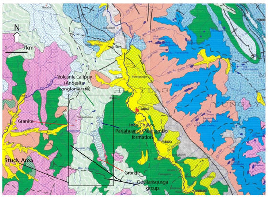
Figure 2.
Geology of the study area showing the main groups, formations, and types [67].
Andesite porosity reinforces geological water storage through the replenishment of underground aquifers that then feed into puquios or natural springs. The presence of a large area of igneous granite around the modern town of Pamparomás, on the lower limit of the survey area along the Chaclancayo River, provides an important quarrying source for stone construction material, especially for the dams and other hydrological features found in the area. Seismically, it is an area of considerable activity as can be evidenced by the numerous fault-lines throughout these still-young fold mountains. This is a key factor in the creation of fissures and the weathering of the underlying Andesite rock of this region.
This region of the Cordillera Negra also represents the intersection between two major recognized eco-zones: the páramo and puna. The Páramo is a cold and humid landscape scarred by ancient glacial action; the average temperatures gravitate around 12 °C with extreme shifts between −23 °C and 23 °C. The often-water-logged soils are acidic (pH 3.7–5.5) and composed of humic black to dark brown earth. As the elevation increases, rock and sand proportions increase leading to a general decrease in water retention. Low atmospheric pressure, intense ultra-violet radiation, extremes of heat loss and accumulation lead to the endemic plant suites whose growth is slow and with low productivity. If severely disrupted, this ecosystem can take a long time to recover [68].
Similarly, the puna, is traditionally described as a harsh, usually dry Alpine meadow tundra located above the treeline; its soils are also highly humic, although with restricted sedimentation [69]. Our area is on the boundary of the puna type identified as humid [70]. The humid puna has daily temperature fluctuations between 25 and −20 °C; ground frost occurs some 300 days a year. The upper puna or puna brava has less sedimentation and is increasingly rugged, cold, and harsh. Traditionally thought of as a setting for a predominantly herding economy, the humid puna nevertheless has a long tradition of agricultural cultivation, usually of bitter potatoes (Solanum x juzepczukii and Solanum x curtilobum) [71].
Both the páramo and puna are what have been described as alpine type ecozones where it is, ‘summer every day and winter every night’ [72]. In the case of the Cordillera Negra, precipitation averages a yearly 500 mm, which is sufficient for rainfed agriculture and for the replenishment of existing páramo/puna wetlands. Nevertheless, the main problem in the Cordillera Negra is, and has always been, the lack of a reliable water supply throughout the year [73]. This means that, if unimpeded, the seasonal rains flow swiftly downslope to the sea. Natural lakes and springs, whilst common to the area [67,74], are not normally very large and are insufficient for local needs.
Prehispanic people appear to have tackled this longstanding problem through the construction of a series of dams and reservoirs that spanned side-valleys and ravines possibly as part of an integrated management of water resources that stretched across whole tributaries and covered the Andean highland section of drainages.
Viewed as whole-of-tributary systems, they potentially significantly increased the water-holding capacity of the affected areas and, in turn, held back a large proportion of the rich highland sediments that would otherwise have been eroded downwards to the coast. Furthermore, scholars have been at pains to highlight the importance that herding and subsequently the puna and páramo ecozones had in the past, with some stating that the herding economy was at least equal to, or greater, than that of agriculture [75].
1.3. Hydraulic Infrastructure and Watershed Management
Elsewhere, I have described how it is useful to think of water technology in the Andes in terms of ‘dry’ or ‘wet’; in which ‘dry’ designates those in which water flows intermittently, for instance terraces, and ‘wet’ are those features in which water is almost always present, such as dams [3]. The same article provides dense descriptions of the main different types of hydrological features found in the Andes. For our purposes here, I will summarize the main features of the technologies pertinent to our study area (Table 1).

Table 1.
Types and categories of hydrological features referred to here.
A crucial aspect of these hydrological features is that they are not present in isolation, rather they are found as packages across the Cordillera Negra, likely creating an interlaced system that links water management strategies from the herding-intense puna down through the mixed herding-farming suni and subsequently to the predominantly agricultural kichwa. In end-effect we appear to have a seamless system of water management linking these agro-pastoralist communities across the gradient of the Cordillera Negra. Nevertheless, this seamlessness is possibly the result of centuries of technological accumulation across watersheds.
Within our study area, I surveyed a total of over 100 archaeological sites, including settlements, tombs, and sacred standing stones. Within this total, there are 21 specific hydrological features and areas (Figure 3). These hydrological features and groups of features were the lynchpin towards harnessing the regions scarce water resources leading to greater economic productivity. A cursory appraisal of the survey data on Figure 3 suffices to show the potentially integrated nature of hydrological technology found in the Pamparomás watershed.
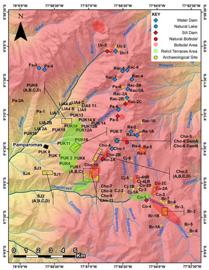
Figure 3.
Map of the study area showing the location of hydrological features, including relict terrace areas and wetlands (bofedal).
The Pamparomás watershed is essentially fed by two large rivers the southern Chaclancayo and the northern Uchpacancha. These two water sources are mentioned in an important local historical document pertaining to a long-running court case over land and water rights between Dominican monks and the local community dating to the end of the 18th and beginning of the 19th century [76]. Here, the Uchpacancha River is known as ‘Río Grande’ or big river, with three other rivers, including the Chaclancayo and its three main tributaries, making up the main water sources for the Pamparomás watershed area (Figure 4 & Table 2).
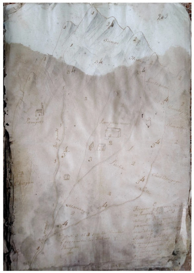
Figure 4.
Map of the Pamparomás area showing the main water sources, Anexo de los Religiosos de Predicadores de Sto. Domingo con los Indios de Pamparomás (Huaráz, setiembre 1803).
Table 2.
The dam and reservoir infrastructure in the study area by the principal river.
Extrapolating from the modern map of the area (Figure 3) I can identify the other two smaller rivers in the 1803 map as the modern Sisuran and Collapampa rivers. In toto, these four collect their waters from natural lakes or anthropogenic dams located in the high-altitude puna/páramo headwater zone directly in respect to the Uchpacancha, Sisuran, and Collapampa rivers or indirectly, as in the case of the Chanclancayo, which gathers it from three smaller tributaries—the Chorillos, Rico, and Colpa.
In fact, the hydraulic system in the study area can be divided into two large blocks, with the Sisuran and Collapampa feeding into the larger Uchpacancha drainage constituting one of these and the Chaclancayo and its tributaries the other. In this respect, the Uchpacancha includes ten water and three silt dams, while the Chaclancayo has four and two, respectively. The large number of water reservoirs positioned above the circum-Pamparomás basin would have sustained the kichwa and suni ecozone agriculture of this area. Nevertheless, the more undulating Chaclancayo drainage also includes the huge Collpacocha silt dam [Co 1], as well as large areas of silt reservoirs making it a particularly productive pastoralist landscape.
Throughout the system, other smaller streams and springs feed into all these rivers, but these constitute the hydrological mainstay of the watershed and, thereby, the areas in which past populations built their hydrological infrastructure. In some instances, these waters fed directly onto terrace systems, and three large areas of abandoned or relict terraces have been identified. It is probable that there were others, but they were most likely dismantled by sub-modern and modern cultivation.
Terrace agriculture is no longer practiced in the area; yet, in the past, these terrace systems were very well integrated into the larger water management system of the area. In this regard, water from the Chorrillos side-valley located in the Chaclancayo drainage, especially from the huge Yanacocha water dam [Cho 1] was diverted by means of an irrigation canal to the Pukio terraces located above the modern town of Pamparomás Figure 5.
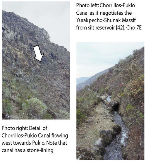
Figure 5.
Stone-lined Chorrillos-Pukio canal.
The crucial point to understand about the construction of this hydraulic infrastructure is the likely interconnectedness of the different features through time. Essentially, beginning in the late Middle Horizon (AD 600–1000) and Late Intermediate Period (AD 1000–1400), the local populations invested heavily in hydraulic engineering to offset increased water insecurity.
It is probable that, through a long process of accretion, these local Huaylas generated an integrated system of water, silt and land management that stretched from the top of the cordillera down to the confluence of the Uchpacancha and Chaclancayo rivers at the site of Tincu near the village of Ullpán (c. 1400 m), thereby, combining herding and farming across this whole altitudinal range. Even so, significant local tributary differences existed. In this regard, altitude is a key determinant in how the hydraulic system of this valley were constituted such that the four main types of ‘wet’ hydrological features invariably occurred in a particular order:
- water dams,
- silt dams,
- silt reservoirs, and
- water reservoirs.
These structures also share a common constructive technique given that they are built of granite blocks on the outside along both faces, while the area between the wall is infilled with a compacted coarse gravel and soil/clay admixture (Figure 6). The stone used in the construction of these features are usually rough-cut, although two, Collpacocha [Co 1] and Yanacocha Hembra [Rac 6], have better cut stone in their construction, perhaps suggesting a later construction date, possibly linked to the Inca expansion into the area.
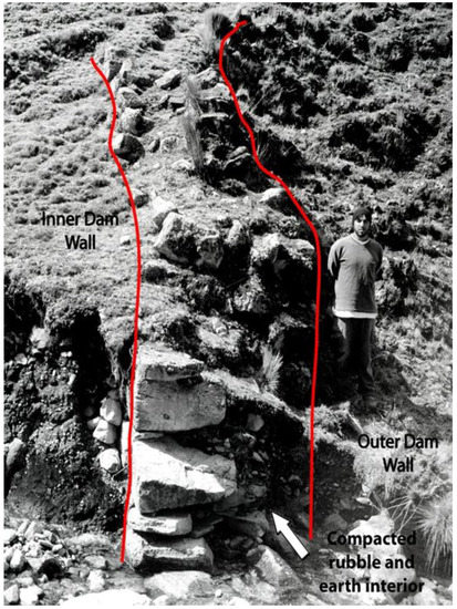
Figure 6.
Profile of the Estanque Dam [Ti 1] showing the inner and outer stone walls, including the central soil and stone infill.
For instance, Collpacocha [Co 1] is located alongside a small Inca administrative site [77]. This construction technique lends the structures robustness and durability, but importantly not fixed rigidity, allowing the structures to resist seismic movement, a common occurrence in this part of the Andes. By way of comparison, modern micro-dams in the area are built using steel rods and cement creating rigid structures, which are all too susceptible to fracture during seismic events [78].
1.3.1. Water Dams
On an individual basis, all these structures are found at different altitudinal heights, with water dams located above 4150 m, within the puna/paramo ecozone. At this altitude, there is little sedimentation from the surrounding geology. Even today, the dammed lakes have little accumulated sediment. It is also likely that the dams were built to augment already pre-existing glacial lakes located within Andesite rock basins. Of all the lakes identified in the study region only one, Itchicocha, was natural providing an example of how these lakes looked like before human intevention. These Prehispanic structures are gravity dams, which use their weight and bulk to provide the wherewithal to hold back water, as such they are roughly triangular with a broader base and narrower crest, mimicking the triangular nature of water pressure.
Water pressure is proportionally greater at the base of a dam, whilst that at the top it is negligible. Normally, the base of modern gravity dams is equal to, or greater than, 0.7-times the height of the dam. Ancient dams typically exceeded this ratio, as seen in all the dams within the study area. Constructively, the gravity dams usually anchor or seal at least one, and where possible both, of their walls onto the natural rock outcrops that exist in this rugged landscape. This is a simple way of giving greater stability and strength to the structure.
The water dams in the study area usually have a varying number of sluice outtakes (known locally as desfogues), whilst a few of the dams have a single sluice located at the base of the structure allowing for a single on-off unregulated flow, likely through the use of a stone-plug. It is possible that the base-level sluice was also used to rid the basin of excess sediment, although it is likewise likely that this would not have been all that effective leading to gradual sedimentation of these structures, especially the lower-lying silt dams (see below).
Some of the more complex structures, such as Yanacocha Hembra [Rac 6], have two sluices, one at the base and one at the crest of the wall, while other examples, such as Ricococha Baja [Ra 1A], have up to six sluices (Figure 7 and Figure 8), allowing for a greater regulation of water flow from the dam, this is similar to the Prehispanic Yanascocha dam registered in the Central Andes by Frank Salomon [17], reiterating that these type of constructions were likely ubiquitous across large stretches of the Andes, especially along the drier Pacific-facing cordilleras.
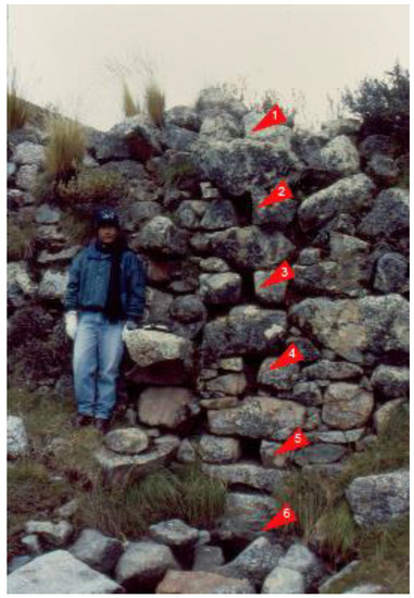
Figure 7.
External face of Ricococha Baja [Ra 1] showing six sluices.
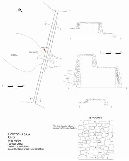
Figure 8.
Plan and profile of Ricococha Baja [Ra 1].
1.3.2. Silt Dams
Ethnohistoric evidence shows that, during the Prehispanic period, there was anthropogenic wetland or bodedal management [56]. This has been validated both archaeologically, e.g., [14], and anthropologically, e.g., [79]. In principle, the basic concept behind this is that, through wetland management and enlargement, large areas of the puna can be turned into a rich plant biota for camelids, especially the more delicate and softer plant-eating alpaca (Lama pacos) [80].
The difference is striking, while a Ha. of normal puna pasture is adequate for between 1 and 2.25 animals [81], a Ha. of bofedal is sufficient for 3.25 animals [82]. In the study area, I have two main types of bofedal or wetland creation: silt dams and silt reservoirs. Both are integral elements to the Prehispanic agropastoralist economies of the area.
In this regard, silt dams bear striking similarities to normal water dams in that they are roughly the same size, constructed of double-faced walls, in-filled with compacted earth, gravel and clay, making an impermeable barrier behind which sediment and water are stored, sometimes they are also anchored or sealed onto natural rock outcrops, although this is not always the case (Figure 9 and Figure 10). The central section of most of the dams is further reinforced by step-like walling, most likely because of the added pressure present in this segment of the structure.
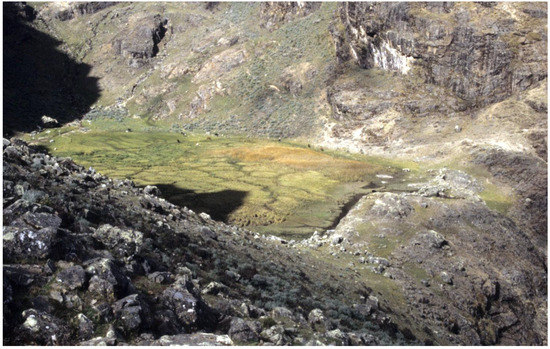
Figure 9.
Huancacocha silt dam [Rac 1].
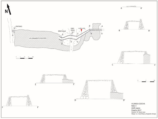
Figure 10.
Plan of the Huancacocha silt dam [Rac 1].
The main difference with water dams is the altitude at which these structures appear, between 3800 and 4450 m. With the sole exception of the small silt dam at Tsaquicocha [Pa 5], located at 4625 m, all the other silt dams are altitudinally lower than their water cousins and in three cases, Tsaquicocha [Uc 3] on the Uchpacancha River, Oleron Cocharuri [Cho 2], and Huancacocha [Rac 1] on the Sisuran River, they are located directly below important water dams, respectively, Negrahuacanan [Uc 2], Yanacocha [Cho 1], and Sacracocha [Rac 2], as part and parcel of an integrated water and soil management system.
Nevertheless, it is also possible that these structures represented an earlier construction phase of water dams at a lower altitude, and it was only after they had sedimented over, effectively becoming silt dams, that this new role was then envisaged for them. Only further research, especially the dating of the lake sediments, e.g., by isotope ratios or pollen, will resolve this issue. That said, it is likely that the construction of these silt dams, whether intentional or not would have been preceded by a period when the area behind the dam wall would have contained an ever-decreasing water basin. This is evident from the soil-sampling data from Collpacocha (Co 1, see below).
Although these features in the area have been interpreted as secondary erosion dams [83] to counteract the effects of periodic landslides known as huaicos, they had more than this one function. Silt dams, like the silt reservoirs that I will describe later, were more than simply features to stop erosion flooding; rather, the silt platforms that they created allowed better pasture to flourish while retaining rich deposits of mineral salts that could also animals ingest through soil-munching. This underscores one of the reasons why silt dams were located altitudinally in areas where sedimentation naturally occurred.
Other differences with water dams existed, for instance, silt dams are not necessarily anchored onto rock outcrops, and they usually have only one discernible outtake sluice located along the base of the structure, usually at its centre. The basic principle governing the silt dam is that of geologic water storage [84]; in this case, the accumulated soil basin acting as an aquifer in which water is stored, filtered and purified through the soil. Since the soil also acts as a barrier to water seepage, the sluice should be viewed rather as a ‘sieve’ drain that siphons excess water out of the basin, whilst the soil retains enough saturated moisture for the growth of bofedal-type conditions for animals.
Silt dams were the result of a slow process of soil accretion or varve-formation [85] through years of careful nurture. Therefore, it is highly probable that some of the larger silt dams retained a small spectrum of water until this was eventually silted over. This seems to have been the case with Collpacocha [Co 1] where soil auguring revealed that the area nearest the dam wall was a lake for a considerable period of time [18]. Likewise, the overflowing conditions experienced today on many of these silt dams, such as Collpacocha [Co 1] and Huancacocha [Rac 1], are not indicative of the way they would have looked during the Prehispanic period.
It is likely that periodic partial de-silting of the structures occurred, with this excess mineral-rich silt possibly reused on nearby terraces and fields for use in agriculture. De-silting has been evidenced in similar structures, such as in the Indian gabarband silt-traps [86], providing a useful analogy for what might have happened in the Andes. Nor is the idea of soil removal a new one in Andean studies, it had already been documented ethnohistorically in the Sixteenth Century [87] and has been suggested as a wide-ranging practice during the Prehispanic period and subsequently [88].
In total, our study area evidences five silt dams: Oleron Cocharuri [Cho 2]; Collpacocha [Co 1]; Tsaquicocha [Pa 5]; Huancacocha [Rac 1]; and Tsaquicocha [Uc 3], covering an area totalling 372,027 m² of anthropogenically enhanced bofedal sufficient to maintain a herd of over 1000 animals for a year, although we also have to consider that these silt dams and their wetlands would likely only have been used at the end of the dry season (July–September) when these might have represented some of the last extant good pasturage before the highland rains.
1.3.3. Silt Reservoirs
Altitudinally below the silt dams, there are a series of irregular, accidented open areas or pampas, especially on the Chorrillos and Rico side-valleys, within which, a series of small, horseshoe-shaped walls were built (Figure 11). This elevation range is significant as, these reservoirs represent a natural progression from the slightly higher-placed silt dams, while also impinging into what has traditionally been viewed as agricultural land along the upper suni range, but which, during the Late Intermediate Period (AD 1000–1450), seems to have been given over to herding [64]. These features trap silt and water behind the wall, thus, creating small bofedal-like wetlands.
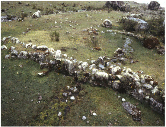
Figure 11.
Two silt reservoirs from Putacayoc-Kaukayoc [Cho 7].
I refer to these features as ‘silt reservoirs’, from the local Spanish term for them—reservorios de limo. They occur below the silt dams and above the agricultural terraces and fields, between c. 3900 and 4400 m, ranging between 7 and 20 m in length, with an average height that ranges between 0.6 and 2 m. These features are similar to erosion-controlling check terraces [89], but are here used to generate small compact wetlands for pasture. They tend to be thicker at the centre of the wall, varying between 0.6 and 1.2 m, although some of the larger constructions reach widths of up to 1.6 m across the center. As with the water dams that they resemble, albeit not in scale, they have a drainage sluice along the central base of the structure, from which excess water seeps out.
Analogous to the other stone features reviewed here, these silt reservoirs are also built with a double-faced stone wall, in-filled with compacted rock and clay. They are set perpendicular to water flow, impeding its uninterrupted movement; this acts as a silt trap and as an erosion barrier to the annual hill-wash episodes and high energy highland discharges that periodically occur in these largely tree-denuded landscape. In turn, the entrapment of silt permits the creation of small bofedal micro-environments behind the walls.
Like the silt and water dams, these silt reservoirs utilise, where possible, the natural rock outcrops, although, as with silt dams, this is not always the case. In total, across the study area, the silt reservoirs cover an approximate area of 300,415 m², representing over 300 Ha. of bofedal. Together with the silt dams above, this totals in the region of c. 700 Ha. of improved pasture reiterating yet again the importance of these types of technology for the provision of pasture at a local level.
1.3.4. Water Reservoirs
Next, there are what Andean scholars have defined as water reservoirs, likely translating from reservorio the Spanish for pond or tank, a small water catchment structure [15,88] similar in principle to the water dams but at a much-reduced scale. Reservoirs have been documented on the coast usually in close association with irrigation canals and the agricultural fields they feed into [90]. Reservoirs in the highlands follow a similar pattern [91], with the added take that these agricultural fields can also be terraces, such that reservoirs serve to regulate water into agricultural terrace systems. This close association between cultivated fields and reservoirs means that these features are normally located at a lower altitude, within the kichwa and suni ecozones.
In our study area, reservoirs appear between 2500 and 3800 m, hugging the limits of viable cultivation. These reservoirs come in a variety of shapes and sizes; round, ovular or roughly rectangular, contorting themselves to the available space, while varying between 10 to 15 m in relative diameter or length, with an average depth of between 1.5 and 3 m. Construction is of a rough coursed-stone internal wall and either a similar external wall or an earthen embankment (Figure 12).
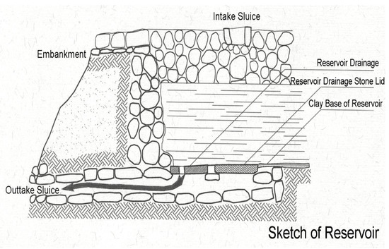
Figure 12.
Sketch of the internal plan of a reservoir adapted from [91].
Reservoirs are fully enclosed structures so that walls bound the structure on all sides. In turn, a canal, either earthen or stone-walled, acts as a feeder channel, diverting water towards the reservoir. An outtake sluice is located at the bottom of the reservoir near to an outtake canal that channels the water from here to the irrigated fields.
As with all hydraulic structures, they are difficult to date, especially if they are found disassociated from datable archaeological sites. Nevertheless, the Prehispanic reservoir of Nununga [Cj 1] (Figure 13) is closely associated to mortuary structures or chullpas [Cj 2] with late Middle Horizon and Late Intermediate Period (AD 900–1400) material providing a potential terminus ante quem for the construction and use of this reservoir. Likewise, in the Chorrillos side-valley, dating of ceramic material found in the adjacent settlements and tombs gives us a similar use date (late MH-LIP). In this side-valley, the water reservoirs are directly placed alongside the agricultural terrace systems of Llanapaccha [Cho 8], thereby, providing water to them.
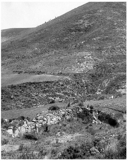
Figure 13.
Water reservoir of Nununga [Cj 1].
1.3.5. Agricultural Terraces
Finally, below the silt terraces there are agricultural terraces. As previously mentioned, these are all now in disuse, but two major types exist in their abandoned state within the study area: sloping field terraces and bench terraces. In all cases, while overall cultivation land is lost through terrace construction, this is ameliorated by the deeper soil matrix created by their construction [15]. Aside from this greater potential productivity, terraces also control erosion and humidity, creating a more sustainable micro-climate amenable to a greater variety of crops, such as maize [75].
Sloping field terraces are the most common type of terracing found in the Andes, usually in side-valleys away from rivers or intermittent streams [15]. Sloping field terraces are built along the natural slope with soil accumulation occurring behind a retainer wall. Although the cultivation zone itself is sloped, the terrace wall acts to level the slope through soil accumulation, allowing for the control of erosion, water run-off, and moisture retention. Sloping field terraces are usually partitioned into discrete parcels incorporating side walls; these can act as conveyors or deflectors of water flow.
These terraces are sometimes irrigated by overhead feeder canals, although the vast majority sustain themselves on the yearly rains, localized springs or slope seepage. These features are, therefore, not regimented into equidistant parallel strips but can occur haphazardly along a mountain flank. The vast majority of these terraces have been documented for areas above 3500 m. In the Central Andes, at this height, there is usually sufficient rainfall for at least one crop a year. In the study area, sloping field terraces have been found at the top of the Chaclancayo Valley around the Huaylas-Inca site of Intiaurán [Co 2] where the land opens up into a wide undulating expanse of suni-puna located between 3800 and 4300 m.
Nevertheless, the study area has larger expanses of abandoned bench terraces. Bench terraces convey a classic image of Andean highland agriculture in which close-fitting stone retaining walls, usually between 1 and 5 m in height, step upwards along the valley sides usually arranged in parallel vertical rows. The walls slope inward, presenting a level planting surface that is typically fed by some form of integrated canal irrigation system.
The terraces of Llanapaccha [Cho 8B], for instance, incorporated a system of main canals fed by catchment reservoirs built alongside the Chorrillos River, from where water was diverted to feed the terraces (Figure 14). Internally, water from the three main canals, offset at the top, middle, and lower parts along the terraced slope would have cascaded downwards throughout the whole system.
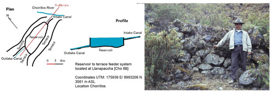
Figure 14.
Right image—Bench terraces of Cho 8B Llanapaccha; Left image—Plan of reservoir and bench terraces at Cho 8B Llanapaccha.
Excavation at one of the bench terraces at Intiaurán [Co 2] revealed that the terrace had a base of small to large cobbles over which a richer humic soil level was present. The first level allowed for good drainage of the terrace, while the second provided the soil matrix necessary for successful agriculture. This is similar to what other researchers have documented across the Andes [88], e.g., [92,93,94]. Bench terracing is found at the lower end of the Chorrillos side-valley, where the Rico Valley joins the Chaclancayo and in a wide area above the modern town of Pamparomás, this last was fed by an important stone-lined canal that connected Chorrillos to the Pukio area (see above).
As can be seen, this area of the Cordillera Negra during, at least, the Late Intermediate Period (AD 1000–1400) and likely earlier, manifested a highly intricate management of water that straddled both herding and farming zones as part of integrated, complex agropastoralist Huaylas communities. Given that the Huaylas settled the Cordillera Negra from at least the Fortaleza River in the South to the Santa in the North, this water management system and the concomitant agropastoralist organisation unpinning it most likely extended itself across this whole mountain range.
Evidence from further north seems to bear this out [21], and, while extensive research to the south is still lacking in this respect, preliminary unpublished surveys by research colleagues seem to show the same pattern emerging in the southern Aija Valley [95].
2. Discussion
The above review details the strong technological interconnectedness within a bounded area across relatively short rivers and side-valleys highlighting the rich hydrological suite employed by the ancient Huaylas populations to counteract the persistent effects of water insecurity in the Cordillera Negra during the Late Intermediate Period and subsequently.
Furthermore, it was this insecurity that must have precipitated these technological investments in the first place. Fluctuating water availability in the face of worsening climatic and environmental conditions, possibly from the late Middle Horizon (AD 600–1000) onwards, necessitated further and sustained technological investment, and it was through these cumulative actions that resilience was generated within the ecological system providing water security to the communities in the area [96].
Resilience within ecological systems is affected by both slow-moving and fast-moving variables in the social sphere that can impact, negatively or positively, these same systems [97]. These social variables can be as important as ecological ones in the long-term stability and equilibrium (or not) of the system, with human ability to adapt to these variable conditioning how a given socio-ecological system bounces back to an appropriate state of equilibrium after disturbance [97].
In this sense, the increasing relevance of the social in ecological systems pushes us to consider the interrelatedness between resilience studies and the wider political ecology behind human decisions in regards to their environment [98,99,100]. In this regard, it is then possible to chart the development of hydraulic technology and the variables determining its success and failure within the context of the Cordillera Negra.
While Middle Horizon (AD 600–1000) Wari or Wari-inspired changes in food production through recourse to hydraulic technology might well have provided the impetus towards the wholescale technological transformation of the Cordillera Negra landscape at this time; it is evident that it was only under the Late Intermediate Period (AD 1000–1400) that small-scale communities move towards stabilising water security played out in its most technologically complex expression.
As previously stated, against a backdrop of increasingly dry and erratic weather patterns commencing towards AD 900, Huaylas communities in the Cordillera Negra negotiated increasing water insecurity through recourse to technology. Herein, it is possible to see a series of slow-moving social and ecological variables that underpinned human strategies in the region, these included the ecological spectrum, climate change, accompanying land degradation, and changes in the water regime, with social variables that emphasised the emergence of community-centred, specialised agropastoralism employing accretional and incremental technological transformation of the landscape to abet wetlands and provide the water security necessary for successful farming and herding production across the vertically stacked ecozones of the region.
From a political ecology standpoint, these small-scale, acephalous communities had little centralised leadership or outside interference, with water and engineering managed and controlled at the local level. Nevertheless, no system is entirely stable [101], and against the slow-moving variables described above, there would have been other fast-moving social and ecological variables that would have affected the resilience of the ecological system, such as persistent drought [2] due to fluctuating patterns of ENSO (El Niño–Southern Oscillation) [102] and SASM (South American Summer Monsoon) [41] during the early Late Intermediate Period, combined with the social variables of rising internecine warfare and raiding as the struggle for resources became more acute throughout the Late Intermediate Period.
This was especially so post-AD 1250, after which there was a general move by human groups to more-easily defended ridge and hill-top settlements [103,104]. It is likely that, this human migration to higher areas, especially in the suni and puna ecozones, further reinforced the socio-economic power of herders within these societies, given that these areas were much better suited to an intensive, specialised pastoralism than any other economic activity.
The incorporation of the Huaylas region into the Inca Empire (AD 1400–1532) bought new social variables into the ecological system, mainly regarding a more extractive political economy. In the short-term, this led to further investments in hydraulic technology in the area, especially around the important wetland of Collpacocha [Co 1] associated with the nearby Inca administrative site of Intiaurán [77] and elsewhere in the study area [105].
Nevertheless, the Inca empire likely brought with it greater political stability, largely ameliorating the effects of internecine warfare and raiding, which, in turn, would have helped guarantee water security and with it a more secure economic return from the region’s ecological system. It is during this period that local population numbers probably reached their Prehispanic peak, with the study area being part of the Inca guaranga (nominally 1000 households) of Mato [106], later the Spanish colonial district of San Luis de Macati, modern-day Macate [25].
At this time and throughout much of the Sixteenth Century, Huaylas was still considered the richest and most populated of the north-central provinces, a reflection of the prosperity and importance that this area held throughout the Inca period and subsequent early colonial era [107]. Even so, Spanish colonisation of the Andes and the Huaylas brought with it new social variables that strongly impacted the prevailing resilience of the study area’s ecological system.
The social (and biological) variables that adversely affected Huaylas resilience were principally two: disease and depopulation. Conservative estimates for the study area put population decline between AD 1534 and 1629 at 63% [18], although the final figure was likely higher given that the Andes experienced considerable population decline already prior to the arrival of the Spanish in AD 1532. European diseases predated the arrival of Francisco Pizarro by at least eight years, decimating in the region of 25–50% of the indigenous population before the Spanish even made landfall in the Central Andes [108].
Even in the Nineteenth Century, travellers to Pamparomás noted the abject poverty as well as reduced state and population of the area [109]. These two factors played havoc on the prevailing ecological system as human depopulation led to the wholesale abandonment of huge swathes of the highlands, especially the upper suni and puna areas, which were largely emptied of people and animals. A declining population required significantly less water, leading to the neglect of much of the ancient installed hydrological capacity of the region, including the water dams, anthropogenically enhanced wetlands and terrace systems.
Only since the mid-twentieth century and, in particular, since the 1970s, has the population recovered sufficiently to start re-stressing the ecological system, a system that is now ill-equipped from a technological standpoint to ensure resilience and water security. There is a danger that new pressures on the system, such as the introduction of water-intense cash crops, for instance avocado, coupled with the greater human use of water due to changing hygiene habits together with climate change will tilt the prevailing ecological system into irreversible crisis, as ecological system transformation leads to ill-adaptation and eventual collapse.
A governmental and NGO-led political ecology emphasising the construction of steel and concrete micro-dams [110] offers short term resilience and a partial solution to water security given that these modern dams, often located on top of, and destroying, their Prehispanic ancestors have a shelf life of some 100 years; considering that endemic seismic activity and a lack of maintenance in the region could reduce this to effectively between 20 and 30 years. New thinking is urgently required if we are to break this cycle of water insecurity and undue stress on the resilience of the region’s ecological system.
3. Conclusions
To conclude, the sheer ubiquity of ancient water engineering systems in the Cordillera Negra is countermanded by their almost complete abandonment in the present. On the basis of a recently funded project, I aim to start reverting this condition through the rehabilitation of part of these ancient systems, while respecting modern rural economic practices that emphasis farming, rather than herding.
Using the past as our model, the underlying aim is to reinstall some of the pre-existing Prehispanic resilience into the modern water management systems of this increasingly water insecure region. Indeed, water insecurity is understood by experts as the single-most important human threat resource in the face of climate change and ever-retreating tropical glaciers [111]. In the non-glaciated Cordillera Negra, this is a particularly pernicious concern, a sentiment echoed by local communities and populations.
While both old and new dams control water and soil erosion, feed subterranean aquifers, and provide water for people’s livelihoods, modern concrete micro-dams are expensive, rely on non-local expertise, and have a curtailed functional lifespan. When they break down, the funds to repair them are not readily available, leading to a significant decrease in existing water levels for the impacted communities.
By way of contrast, the ancient dams of the area were the product of century-long engineering projects that seamlessly integrated these technologies with their immediate landscape. They were based on local know-how and were easily maintained by the community. Crucially, for these cash-strapped regions, these stone and clay constructions are cheap to build and upkeep. They are also resilient, after close to 1000 years of negligible maintenance, most of them are still standing and potentially functioning.
In this regard, our rehabilitation project is rooted in a respect for community and local knowledge and allied to flexible modern engineering to shore up the effectiveness of these ancient structures. I contend that modern engineering can only provide partial solutions to increasing water insecurity in the Andes, and that the marriage between past and present knowledge and technology can deliver a better, locally informed answer to future water security and climate change in the Cordillera Negra.
Thinking ahead, ancient dams are common to the Andean highlands; therefore, success on this rehabilitation project will provide a further cheap, easily applicable, community-based solution to water scarcity across large areas of these hydrologically challenged highlands. Let us hope it does.
Funding
Funding for this research was provided by Alexander von Humboldt Foundation (2010–2011), Anthony Wilkins Fund (2001–2003), British Academy (2008–2010), Chadwick Fund (2001-2003), Crowther-Beynon Fund (2001–2003), Dorothy Garrod Fund (2001–2003), Gerda Henkel Foundation (2021–2023), Leverhulme Trust (2008–2010), Ridgeway-Venn Fund (2001–2003), and the (2001–2004).
Institutional Review Board Statement
Not applicable.
Informed Consent Statement
Not applicable.
Conflicts of Interest
The author declares no conflict of interest.
References
- Kosok, P. Life, Land, and Water in Ancient Peru; An Account of the Discovery, Exploration, and Mapping of Ancient Pyramids, Canals, Roads, Towns, Walls, and Fortresses of Coastal Peru with Observations of Various Aspects of Peruvian Life, Both Ancient and Modern; Long Island University Press: New York, NY, USA, 1965. [Google Scholar]
- Ortloff, C.R. Water Engineering in the Ancient World: Archaeological and Climate Perspectives on Societies of Ancient South America, the Middle East, and South-East Asia; Oxford University Press: Oxford, UK, 2010. [Google Scholar]
- Lane, K. Water Technology in the Andes. In Encyclopaedia of the History of Science, Technology, and Medicine in Non-Western Cultures; Selin, H., Ed.; Springer: New York, NY, USA, 2014; pp. 1–24. [Google Scholar]
- Mark, B.G.; Mckenzie, J.M. Tracing Increasing Tropical Andean Glacier Melt with Stable Isotopes in Water. Environ. Sci. Technol. 2007, 41, 6955–6960. [Google Scholar] [CrossRef]
- Olarte Navarro, B. La Cuenca Del Río Chillón: Problemática y Potencial Productivo. Ing. Ind. 2007, 25, 53–68. [Google Scholar] [CrossRef]
- Tremolada, P.; Villa, S.; Bazzarin, P.; Bizzotto, E.; Comolli, R.; Vighi, M. POPs in Mountain Soils from the Alps and Andes: Suggestions for a ‘Precipitation Effect’ on Altitudinal Gradients. Water Air. Soil Pollut. 2008, 188, 93–109. [Google Scholar] [CrossRef]
- Covey, R.A. Multiregional Perspectives on the Archaeology of the Andes during the Late Intermediate Period (c. A.D. 1000–1400). J. Archaeol. Res. 2008, 16, 287–338. [Google Scholar] [CrossRef]
- Lanning, E.P. Current Research: Highland South America. Am. Antiq. 1965, 31, 139–140. [Google Scholar]
- Lane, K. Through the Looking Glass: Re-Assessing the Role of Agro-Pastoralism in the North-Central Andean Highlands. World Archaeol. 2006, 38, 493–510. [Google Scholar] [CrossRef]
- Pärssinen, M. Tawantinsuyu: El Estado Inca y Su Organización Política; Travaux de l’Institut Francais d’Études Andines; IFEA/Fondo Editorial de la Pontificia Universidad Católica del Perú/Embajada de Finlandia: Lima, Peru, 2003. [Google Scholar]
- Mächtle, B.; Eitel, B. Fragile Landscapes, Fragile Civilizations—How Climate Determined Societies in the Pre-Columbian South Peruvian Andes. Catena 2012, 107, 62–73. [Google Scholar] [CrossRef]
- Morehart, C.T.; Millhauser, J.K.; Juarez, S. Archaeologies of Political Ecology: Genealogies, Problems, and Orientations. Archaeol. Pap. Am. Anthropol. Assoc. 2018, 29, 5–29. [Google Scholar] [CrossRef]
- Robbins, P. Political Ecology: A Critical Introduction; Critical Introductions to Geography; Blackwell Publishing: Oxford, UK, 2004. [Google Scholar]
- Lane, K. Water, Silt and Dams: Prehispanic Geological Storage in the Cordillera Negra, North-Central Andes, Peru. Rev. Glaciares Ecosistemas Mont. 2017, 2, 41–50. [Google Scholar]
- Denevan, W.M. Cultivated Landscapes of Native Amazonia and the Andes; Oxford Geographical and Environmental Studies Series; Clark, G., Ed.; Oxford University Press: Oxford, UK, 2001. [Google Scholar]
- Scarborough, V.L. The Flow of Power: Ancient Water Systems and Landscapes; School of American Research Press: Santa Fe, NM, USA, 2003. [Google Scholar]
- Salomon, F. Collquiri’s Dam: The Colonial Re-Voicing of an Appeal to the Archaic. In Native Traditions in the Postconquest World: A Symposium at Dumbarton Oaks, 2nd through 4th October 1992; Hill Boone, E., Cummins, T., Eds.; Dumbarton Oaks Research Library and Collection: Washington, DC, USA, 1998; pp. 265–293. [Google Scholar]
- Lane, K. Engineering the Puna: The Hydraulics of Agro-Pastoral Communities in a North-Central Peruvian Valley. Ph.D. Thesis, University of Cambridge, Cambridge, UK, 2006. [Google Scholar]
- Vivanco Pomacanchari, C. Obras Hidráulicas de Etapa Prehispánica En Huaccana, Chincheros—Apurímac. Arqueol. Soc. 2015, 30, 315–333. [Google Scholar] [CrossRef]
- Palacios, J. Agua: Ritual y Culto En Yañac (Ñaña): La Montaña Sagrada; Universidad Peruana Unión: Lima, Peru, 2017. [Google Scholar]
- Combey, A. Dynamiques Spatiales et Mobilités Dans La Cordillère Noire: Permanences et Évolutions, Vallon De Capado, Ancash, Pérou Horizon Ancien (900–300 Av. J.-C.)–Horizon Récent (1460–1532 Apr. J.-C.); Sorbonne: Paris, France, 2018. [Google Scholar]
- Lanzelotti, S.L. Indicadores Para El Reconocimiento de Represas Arqueológicas. Relac. Soc. Argent. Antropol. 2011, XXXVI, 177–196. [Google Scholar]
- Wittfogel, K.A. Oriental Despotism: A Comparative Study of Total Power; Yale University Press: New Haven, CT, USA, 1957. [Google Scholar]
- Lane, K. Engineered Highlands: The Social Organisation of Water in the Ancient North-Central Andes (AD 1000–1480). World Archaeol. 2009, 41, 169–190. [Google Scholar] [CrossRef]
- Aibar Ozejo, E. La Visita de Guaraz En 1558. Cuad. Semin. Hist. Inst. Riva Agüero 1968, 9, 5–21. [Google Scholar]
- Brush, S.B.; Gulliet, D.W. Small-Scale Agro-Pastoral Production in the Central Andes. Mt. Res. Dev. 1985, 5, 19–30. [Google Scholar] [CrossRef]
- Zimmerer, K.S. Wetland Production and Smallholder Persistence: Agricultural Change in a Highland Peruvian Region. Ann. Assoc. Am. Geogr. 1991, 81, 443–463. [Google Scholar] [CrossRef]
- Mayer, E. The Articulated Peasant: Household Economies in the Andes; Westview Press: Boulder, CO, USA, 2002. [Google Scholar]
- Rasmussen, M.B. Andean Waterways: Resource Politics in Highland Peru; University of Washington State: Seattle, WA, USA; London, UK, 2015. [Google Scholar]
- Grant, J.L.; Lane, K. The Political Ecology of Late South American Pastoralism: An Andean Perspective A.D. 1000–1615. J. Polit. Ecol. 2018, 25, 446–469. [Google Scholar]
- Kolata, A.L. Tiwanaku and Its Hinterland; Smithsonian Institution Press: Washington, DC, USA, 1996. [Google Scholar]
- Schreiber, K.J. Wari Imperialism in Middle Horizon Peru; Anthropological Papers of the Museum of Anthropology; University of Michigan Press: Ann Arbor, MI, USA, 1992; Volume 28. [Google Scholar]
- Calaway, M.J. Ice-Cores, Sediments and Civilization Collapse: A Cautionary Tale from the Lake Titicaca. Antiquity 2005, 79, 778–790. [Google Scholar] [CrossRef]
- Arnold, T.E.; Hillman, A.L.; Abbott, M.B.; Werne, J.P.; McGrath, S.J.; Arkush, E.N. Drought and the Collapse of the Tiwanaku Civilization: New Evidence from Lake Orurillo, Peru. Quat. Sci. Rev. 2021, 251, 106693. [Google Scholar] [CrossRef]
- Marsh, E.J.; Contreras, D.; Bruno, M.C.; Vranich, A.; Roddick, A.P. Comment on Arnold et al. “Drought and the Collapse of the Tiwanaku Civilization: New Evidence from Lake Orurillo, Peru” [Quat. Sci. Rev. 251: 106693]. Quat. Sci. Rev. 2021, 251, 107004. [Google Scholar] [CrossRef]
- Sandweiss, D.H.; Maasch, K.A.; Landazuri, H.A.; Leclerc, E. Comment on Arnold et al. (2021): CP in the MCA? Quat. Sci. Rev. 2021, 269, 107053. [Google Scholar] [CrossRef]
- Kellerhals, T.; Brütsch, S.; Sigl, M.; Knüsel, S.; Gäggeler, H.W.; Schwikowski, M. Ammonium Concentration in Ice Cores: A New Proxy for Regional Temperature Reconstruction? J. Geophys. Res. 2010, 115, D16123. [Google Scholar] [CrossRef] [Green Version]
- Neukom, R.; Luterbacher, J.; Villalba, R.; Küttel, M.; Frank, D.; Jones, P.D.; Grosjean, M.; Wanner, H.; Aravena, J.-C.; Black, D.E.; et al. Multiproxy Summer and Winter Surface Air Temperature Field Reconstructions for Southern South America Covering the Past Centuries. Clim. Dyn. 2011, 37, 35–51. [Google Scholar] [CrossRef] [Green Version]
- Thompson, L.G.; Mosley-Thompson, E.; Davis, M.E.; Zagorodnov, V.S.; Howat, I.M.; Mikhalenko, V.N.; Lin, P.N. Annually Resolved Ice Core Records of Tropical Climate Variability over the Past ~1800 Years. Science 2013, 340, 945–950. [Google Scholar] [CrossRef] [Green Version]
- Baker, P.A.; Seltzer, G.O.; Fritz, S.C.; Dunbar, R.B.; Grove, M.J.; Tapia, P.M.; Cross, S.L.; Rowe, H.D.; Broda, J.P. The History of South American Tropical Precipitation for the Past 25,000 Years. Science 2001, 291, 640–643. [Google Scholar] [CrossRef] [Green Version]
- Bird, B.W.; Abbott, M.; Vuille, M.B.; Rodbell, D.T.; Stansell, N.D.; Rosenmeier, M.F. A 2300-Year-Long Annually Resolved Record of the South American Summer Monsoon from the Peruvian Andes. Proc. Natl. Acad. Sci. USA 2011, 108, 8583–8588. [Google Scholar] [CrossRef] [Green Version]
- Schreiber, K.J. Conquest and Consolidation: A Comparison of the Wari and Inka Occupations of a Highland Peruvian Valley. Am. Antiq. 1987, 52, 266–284. [Google Scholar] [CrossRef]
- Vining, B.; Williams, P.R. Crossing the Western Altiplano: The Ecological Context of Tiwanaku Migrations. J. Archaeol. Sci. 2020, 113, 105046. [Google Scholar] [CrossRef]
- Finucane, B.; Maita Agurto, P.; Isbell, W.H. Human and Animal Diet at Conchopata, Peru: Stable Isotope Evidence for Maize Agriculture and Animal Management Practices during the Middle Horizon. J. Archaeol. Sci. 2006, 33, 1766–1776. [Google Scholar] [CrossRef]
- Browman, D.L. Origins and Development of Andean Pastoralism: An Overview of the Past 6000 Years. In The Walking Larder: Patterns of Domestication, Pastoralism and Predation; Clutton-Block, J., Ed.; Unwin-Hyman: London, UK, 1989; pp. 256–268. [Google Scholar]
- Duviols, P. Huari y Llacuaz: Agricultores y Pastores: Un Dualismo Prehispánico de Oposición y Complementaridad. Rev. Mus. Nac. 1973, 39, 153–191. [Google Scholar]
- Rostworowski, M. Conflicts over Coca Fields in XVIth-Century Peru; Studies in Latin American Ethnohistory and Archaeology; Marcus, J., Ed.; University of Michigan Press: Ann Arbor, MI, USA, 1988; Volume 21. [Google Scholar]
- Orlove, B.S. Native Andean Pastoralists: Traditional Adaptations and Recent Changes. In Contemporary Nomadic and Pastoral Peoples: Africa and Latin America; Salzman, P.C., Ed.; College of William and Mary: Williamsburg, VI, USA, 1982; Volume 17, pp. 95–136. [Google Scholar]
- Salzman, P.C. Pastoralists: Equality, Hierarchy, and the State; Westview Press: Oxford, UK, 2004. [Google Scholar]
- Lane, K. The State They Were in: Community, Continuity and Change in the North-Central Andes, 1000AD–1608AD. In Socialising Complexity: Structure, Integration and Power; Kohring, S., Wynne-Jones, S., Eds.; Oxbow: Oxford, UK, 2007; pp. 76–99. [Google Scholar]
- Fleming, D. Can We Ever Understand the Inca Empire? In 28th Northeast Conference on Andean Archaeology and Ethnohistory; State University of New York: New York, NY, USA, 2016. [Google Scholar]
- Evans-Pritchard, E.E. The Nuer: A Description of the Modes of Livelihood and Political Institutions of a Nilotic People; Oxford University Press: Oxford, UK, 1940. [Google Scholar]
- Zuloaga Rada, M. La Conquista Negociada: Guarangas, Autoridades Locales e Imperio en Huaylas Perú; IEP: Lima, Peru, 2012. [Google Scholar]
- Espinoza Soriano, W. Etnia Guaylla (Ahora Huaylas). Investig. Soc. 2013, 17, 179–190. [Google Scholar] [CrossRef]
- Isbell, W.H. Mummies and Mortuary Monuments: A Postprocessual Prehistory of Central Andean Social Organization; University of Texas Press: Austin, TX, USA, 1997. [Google Scholar]
- Guaman Poma de Ayala, F. Nueva Crónica y Buen Gobierno; Fondo de Cultura Economica: Lima, Peru, 1993; Volume 1–3. [Google Scholar]
- de Avila, F. Ritos y Tradiciones de Huarochirí, 2nd ed.; Travaux de l’Institut Francais d’Études Andines; IFEA, Banco Central de Reserva Del Peru, Universidad Particular Ricardo Palma: Lima, Peru, 1999; Volume 116. [Google Scholar]
- Paerregaard, K. Complementarity and Duality: Oppositions between Agriculturists and Herders in an Andean Village. Ethnology 1992, 31, 15–26. [Google Scholar] [CrossRef]
- Mitchell, W.P.; Guillet, D. Irrigation at High Altitudes: The Social Organization of Water Control Systems in the Andes; Ehrenreich, J.D., Ed.; Society for Latin American Anthropology Publication Series; American Anthropological Association: Washington, DC, USA, 1994; Volume 12. [Google Scholar]
- Gelles, P.H. Water and Power in Highland Peru: The Cultural Politics of Irrigation and Development; Rutgers University Press: New Brunswick, NB, USA, 2000. [Google Scholar]
- Trawick, P.B. The Struggle for Water in Peru: Comedy and Tragedy in the Andean Commons; Stanford University Press: Stanford, UK, 2003. [Google Scholar]
- Zuidema, R.T. Kinship and Ancestor Cult in Three Peruvian Communities. Hernández Príncipe’s Account of 1622. Bull. Inst. Fr. DÉtudes Andin. 1973, 2, 16–33. [Google Scholar]
- Gose, P. Segmentary State Formation and the Ritual Control of Water under the Incas. Comp. Stud. Soc. Hist. 1993, 35, 480–514. [Google Scholar] [CrossRef]
- Lane, K.; Grant, J.L. A Question of Altitude: Exploring the Limits of Highland Pastoralism in the Prehispanic Andes. In The Archaeology of Andean Pastoralism; Capriles, J.M., Tripcevich, N., Eds.; University of New Mexico Press: Albuquerque, Mexico, 2016; pp. 139–157. [Google Scholar]
- Pérez-Flores, P.; Wang, G.; Mitchell, T.M.; Meredith, P.G.; Nara, Y.; Sarkar, V.; Cembrano, J. The Effect of Offset on Fracture Permeability of Rocks from the Southern Andes Volcanic Zone, Chile. J. Struct. Geol. 2017, 104, 142–158. [Google Scholar] [CrossRef]
- Jamtveit, B.; Kobchenko, M.; Austrheim, H.; Malthe-Sørenssen, A.; Røyne, A.; Svensen, H. Porosity Evolution and Crystallization-Driven Fragmentation during Weathering of Andesite. J. Geophys. Res. Solid Earth 2011, 116, B12204. [Google Scholar] [CrossRef]
- INRENA. Base de Datos de Recursos Naturales e Infrastructura: Departamento de Ancash-Primera Aproximacion; INRENA/Ministerio de Agricultura: Lima, Peru, 2000; p. 166. [Google Scholar]
- Luteyns, J.L. Páramos: Why Study Them? In Páramo: An Andean Ecosystem under Human Influence; Balslev, H., Luteyns, J.L., Eds.; Academic Press: London, UK; New York, NY, USA, 1992; pp. 1–14. [Google Scholar]
- Luteyns, J.L.; Churchill, S.P. Vegetation of the Tropical Andes: An Overview. In Imperfect Balance: Landscape Transformations in the Precolumbian Americas; Lentz, D.L., Ed.; Columbia University Press: New York, NY, USA, 2000; pp. 281–310. [Google Scholar]
- Custred, G. Las Punas de Los Andes Centrales. In Pastores de Puna: Uywamichiq Punarunakuna; Flores Ochoa, J.A., Ed.; Instituto de Estudios Peruanos (IEP): Lima, Peru, 1977; pp. 55–85. [Google Scholar]
- Young, K.R.; León, B.; Herrera-MacBryde, O. Peruvian Puna. In Centres of Plant Diversity: A Guide and Strategy for Their Conservation; Davis, S.D., Heywood, V.H., Herrera-MacBryde, O., Villa-Lobos, J., Hamilton, A.C., Eds.; WWF/IUCN: Cambridge, UK, 1997; Volume 3, pp. 470–476. [Google Scholar]
- Hedberg, O. Features of Afroalpine Plant Ecology; Acta Phytogeographica Suecica; Almqvist & Wiksells Boktryckeri AB: Uppsala, Sweden, 1964. [Google Scholar]
- Tosi, J.A. Zonas de Vida Natural En El Peru; Instituto Interamericano de Ciencias Agricolas de la OEA, Zona Andina: Lima, Peru, 1960. [Google Scholar]
- ONERN. Inventario Nacional de Lagunas y Represamientos; ONERN: Lima, Peru, 1984. [Google Scholar]
- Treacy, J.M. Las Chacras de Coporaque; Estudios de la Sociedad Rural; Instituto de Estudios Peruanos: Lima, Peru, 1994. [Google Scholar]
- Anonymous. Anexo de Los Religiosos de Predicadores de Sto. Domingo con los Indios de Pamparomás, Archivo Comunitario de Pamparomás: Pamparomas, 1774. [Google Scholar]
- Lane, K.; Contreras Ampuero, G. An Inka Administrative Site in the Ancash Highlands, North-Central Andes. Past Newsl. Prehist. Soc. 2007, 56, 13–15. [Google Scholar]
- Llosa Larrabure, J. Elaboración e Implementación de Un Programa Nacional de Adaptación al Cambio Climático, Con Énfasis En Zonas Seleccionadas de La Sierra Centro y Sur Del País; CONCYTEC/OAJ—Contrato de Subvención No064: Lima, Peru, 2008. [Google Scholar]
- Palacios Rios, F. Pastizales de Regadío Para Alpacas En La Puna Alta (El Ejemplo de Chichillapi). In Comprender la agricultura campesina en los Andes Centrales: Perú-Bolivia; Morlon, P., Ed.; IFEA/CBC: Lima, Peru, 1996; pp. 207–212. [Google Scholar]
- Verzijl, A.; Guerrero Quispe, S. The System Nobody Sees: Irrigated Wetland Management and Alpaca Herding in the Peruvian Andes. Mt. Res. Dev. 2013, 33, 280–293. [Google Scholar] [CrossRef]
- CEDEP. Experiencia de Repoblamiento de Alpacas en La Sierra de Ancash; CEDEP, Lima as Internal Memo, Centro de Estudios para el Desarrollo y la Participación: Lima, Peru, 1997. [Google Scholar]
- Browman, D.L. High Altitude Camelid Pastoralism of the Andes. In The World of Pastoralism: Herding Systems in Comparative Perspective; Galaty, J.G., Johnson, D.L., Eds.; Guilford Press: New York, NY, USA, 1990; pp. 323–352. [Google Scholar]
- Freisem, C. Vorspanische Speicherbecken in Den Anden: Eine Komponente Der Bewirtschaftung von Einzugsgebieten Das Beispiel Nepeñatal—Peru. Diploma Thesis, Technische Universität Berlin, Berlin, Germany, 1998. [Google Scholar]
- Fairley, J.P. Geologic Water Storage in Precolumbian Peru. Lat. Am. Antiq. 2003, 14, 193–206. [Google Scholar] [CrossRef]
- Leet, L.D. Physical Geology; Prentice Hall: Engelwood Cliffs, NJ, USA, 1982. [Google Scholar]
- Possehl, G.L. The Chronology of Gabarbands and Palas in Western South Asia. Expedition 1975, 17, 33–37. [Google Scholar]
- Cieza de León, P. Crónica Del Peru: Segunda Parte, 3rd ed.; Colección Clásicos Peruanos; Franklin Pease, G.Y., Ed.; Pontificia Universidad Católica del Peru/Academia Nacional de la Historia: Lima, Peru, 1996. [Google Scholar]
- Donkin, R.A. Agricultural Terracing in the Aboriginal New World; Viking Fund Publications in Anthropology 56; University of Arizona Press: Tucson, AZ, USA, 1979. [Google Scholar]
- Zuccarelli Freire, V.; Meléndez, A.S.; Rodriguez Oviedo, M.; Quesada, M.N. Erosion Control in Prehispanic Agrarian Landscapes from Northwestern Argentina: El Alto-Ancasti Highlands Case Study (Catamarca, Argentina). Geoarchaeology 2021, 1–21. [Google Scholar] [CrossRef]
- Netherly, P.J. The Management of Late Andean Irrigation Systems on the North Coast of Peru. Amercian Antiq. 1984, 49, 227–254. [Google Scholar] [CrossRef]
- Venturi, F.; Villanueva, S. El Manejo Del Agua en la Cordillera Negra: Estudio Elaborado Por Encargo Del Programa Cordillera Negra en Los Distritos de Huaylas y Huata; Programa Cordillera Negra, Programa de Lucha Contra la Pobreza en Zonas Rurales de la Region Chavin: Huaraz, Peru, 2002. [Google Scholar]
- Bonavia, D. Investigaciones Arqueológicas En El Mantaro Medio. Rev. Mus. Nac. 1967, 35, 211–294. [Google Scholar]
- Schjellerup, I. Andenes y Camellones En La Región de Chachapoyas. In Andenes y Camellones en el Peru Andino: Historia, Presente y Futuro; de la Torre, C., Burga, M., Eds.; CONCYTEC: Lima, Peru, 1986; pp. 133–150. [Google Scholar]
- Keeley, H.C.M. Soils of Prehistoric Terrace Systems in the Cusichaca Valley, Peru. Br. Archaeol. Rep. Int. Ser. 1985, 232, 547–568. [Google Scholar]
- Herrera, A. CROPP Report on Archaeological Field Reconnaissance in the Pescado River Valley, La Merced District, Aija Province, Cordillera Negra, Conducted January 2nd to January 6th 2021; CROPP: Bogota, Colombia, 2021; pp. 1–18. [Google Scholar]
- Holling, C.S. Engineering Resilience vs. Ecological Resilience. In Engineering within Ecological Constraint; Schulze, P.C., Ed.; National Academy Press: Washington, DC, USA, 1996; pp. 31–43. [Google Scholar]
- Beymer-Farris, B.A.; Bassett, T.J.; Bryceson, I. Promises and Pitfalls of Adaptive Management in Resilience Thinking: The Lens of Political Ecology. In Resilience and the Cultural Landscape: Understanding and Managing Change in Human-Shaped Environments; Plieninger, T., Bieling, C., Eds.; Cambridge University Press: Cambridge, UK, 2012; pp. 283–299. [Google Scholar]
- Peterson, G. Political Ecology and Ecological Resilience: An Integration of Human and Ecological Dynamics. Ecol. Econ. 2000, 35, 323–336. [Google Scholar] [CrossRef]
- Turner, M.D. Political Ecology I: An Alliance with Resilience. Prog. Hum. Geogr. 2013, 38, 616–623. [Google Scholar] [CrossRef]
- Kull, C.A.; Haripriya, R. Political Ecology and Resilience: Competing Interdisciplinarities? In Interdisciplinarités entre Natures et Sociétés; Hubert, B., Mathieu, N., Eds.; PIE Peter Lang: Brussels, Belgium, 2016; pp. 71–87. [Google Scholar]
- Lentz, D.L. Introductions: Definitions and Conceptual Underpinnings. In Imperfect Balance: Landscape Transformations in the Precolumbian Americas; Lentz, D.L., Ed.; Columbia University Press: New York, NY, USA, 2000; pp. 1–13. [Google Scholar]
- Sandweiss, D.H.; Andrus, C.F.T.; Kelley, A.R.; Maasch, K.A.; Reitz, E.J.; Roscoe, P.B. Archaeological Climate Proxies and the Complexities of Reconstructing Holocene El Niño in Coastal Peru. Proc. Natl. Acad. Sci. USA 2020, 117, 8271. [Google Scholar] [CrossRef] [Green Version]
- Langlie, B.S.; Arkush, E.N. Managing Mayhem: Conflict, Environment, and Subsistence in the Andean Late Intermediate Period, Puno, Peru. In The Archaeology of Food and Warfare; VanDerwarker, A.M., Wilson, G.D., Eds.; Springer: Basel, Switzerland, 2016; pp. 259–289. [Google Scholar]
- Arkush, E. Hillforts of the Ancient Andes: Colla Warfare, Society, and Landscape; University Press of Florida: Gainesville, FL, USA, 2011. [Google Scholar]
- Lane, K. Hincapié En Los Andes Nor-Centrales: La Presencia Inca En La Cordillera Negra, Sierra de Ancash. In Arquitectura Prehispánica Tardía: Construcción y Poder en Los Andes Centrales; Lane, K., Luján Dávila, M., Eds.; UCSS/CEPAC: Lima, Peru, 2011; pp. 123–170. [Google Scholar]
- Ampuero, F.; Yupanqui, I. Información Hecha Por Francisco de Ampuero y Doña Ines Yupanqui, Su Mujer, Vecinos de La Cuidad de Los Reyes, Sobre La Recompensa Que Piden Se Les Haga Del Repartimiento de Guíalas, Cuyas Guarangas Disfruto Contarguacho. Rev. Mus. Nac. 1976, XLII, 272–288. [Google Scholar]
- Levillier, D.R. Gobernantes de Perú: Cartas y Papeles Siglo XVI: El Virrey Garcia de Hurtado de Mendoza, Marques de Cañete; Documentos del Archivo de Indias; Colección de Publicaciones Históricas de la Biblioteca de Congreso Argentino: Madrid, Spain, 1926; Volume XIII. [Google Scholar]
- Cook, N.D. Born to Die: Disease and New World Conquest, 1492–1650; University of Cambridge Press: Cambridge, UK, 1998. [Google Scholar]
- Raimondi, A. El Peru, Tomo I, Parte Preliminar; Imprenta del Estado: Lima, Preu, 1874. [Google Scholar]
- Junta de Desarrollo Distrital de Pamparomás. Proyecto: Uso Productivo Del Agua y Desarrollo Agroecológico de La Microcuenca Chaclancayo; Junta de Desarrollo Distrital de Pamparomas: Pamparomas, Peru, 2000. [Google Scholar]
- Gleick, P.H.; Ajami, N.; Juliet, C.-S.; Cooley, H.; Donneley, K.; Fulton, J.; Ha, M.-L.; Herberger, M.; Moore, E.; Morrison, J.; et al. The World’s Water Volume 8: The Biennial Report on Freshwater Resources Paperback; Island Press: Washington, DC, USA, 2014. [Google Scholar]
Publisher’s Note: MDPI stays neutral with regard to jurisdictional claims in published maps and institutional affiliations. |
© 2021 by the author. Licensee MDPI, Basel, Switzerland. This article is an open access article distributed under the terms and conditions of the Creative Commons Attribution (CC BY) license (https://creativecommons.org/licenses/by/4.0/).