Article

Retaining Relative Height Information: An Enhanced Technique for Depression Treatment in Digital Elevation Models

1
State Key Laboratory of Earth Surface Processes and Resource Ecology, Academy of Disaster Reduction and Emergency Management, Beijing Normal University, Beijing 100875, China
2
Key Laboratory of Environmental Change and Natural Disaster, Ministry of Education, Faculty of Geographical Science, Beijing Normal University, Beijing 100875, China
3
Guangdong Climate Center, Guangzhou 510640, China
*
Author to whom correspondence should be addressed.
Water 2021, 13(23), 3347; https://doi.org/10.3390/w13233347
Submission received: 14 September 2021 / Revised: 16 November 2021 / Accepted: 22 November 2021 / Published: 25 November 2021
(This article belongs to the Special Issue Research Progress on Watershed Ecohydrological Processes)

Abstract

:
This study presents an enhanced variant of the priority-flood based algorithm proposed by Wang and Liu for treating depressions in digital elevation models (DEMs). The enhanced variant redefines spill elevation, the key concept of the original algorithm, as the lowest elevation that a pixel needs to have to ensure a non-ascending path toward the border of the DEM, plus the larger of a small number (~0.001) and the difference between the unaltered elevation values of the focal pixel and its immediate downhill neighbor. This redefinition is adopted to obtain an intermediate elevation surface to direct flow and ultimately to carve the original DEM. Each carving starts from a depression bottom and propagates downstream until a downhill cell is guaranteed in the original DEM. Tests of these algorithms on a complex terrain of the 260,000 km2 Sichuan structural basin in China shows that the enhanced algorithm maximally preserves the original flow directions and extracts realistic drainage networks. Retaining the relative heights, and therefore flow directions, of cells within depressions allows the new algorithm to offer a depressionless DEM with small modification of its origin for further hydrologic applications. The enhanced depression treatment algorithm is provided as the freely available tool BNUSinkRemv.

1. Introduction

Surface topographic depressions are areas in a digital elevation model (DEM) that are bounded by cells with higher elevations. Being either natural or artificial, depressions are unavoidable in DEMs and are often necessary to be removed [1,2,3,4,5,6,7] to support hydrological analysis such as calculation of slope and topographic index [8], extraction of channel networks [9,10], and other applications [9,11,12,13,14].
With increasing accessibility to finer resolution DEMs, depression treatment algorithms that can efficiently process large DEM data sets are required. Among many [3,4,7,10,13,15,16,17,18,19,20,21], Wang and Liu [1] proposed a floating-point priority-flood algorithm with a time complexity of O ( N l o g N ) (N is the number of grid cells of a DEM) for filling depressions, determining flow directions, and labeling watersheds. Spill elevation, the key concept of their algorithm, was defined as the minimum elevation that a pixel needs to be raised by to have a non-ascending path toward the DEM edge. Its implementation leads to mathematical flat areas in the sink-filled DEM, which confound the further calculation of accurate flow directions [3]. Two priority-flood-based variants have been introduced to alleviate this difficulty in directing flow for cells within depressions. One is to incorporate the Planchon and Darboux’s [2] ε-descending path concept, i.e., to let adjacent cells along paths flowing to the depression outlet have some minimal elevation difference ε. Barnes et al. [3] described such an algorithm and cautioned the issue of selecting an appropriate positive value of ε that is large enough to direct flow but is sufficiently small to avoid other effects on the DEM’s hydrologic properties. The other is to force the neighbors of the lowest cell to point toward it regardless of their slopes, and uses the unaltered elevations as their priorities in the priority queue. This approach was developed by Metz et al. [10] and elaborated by Barnes et al. [3]. The priority-flooding algorithm has been reported to has low time complexity of about O ( N l o g N ) for floating-point data, and therefore is adopted in this study.
The goal of depression treatment algorithms is often to direct flow continuously and accurately from catchment divides to outlets with least alteration of the original DEM [4,22]. Depressions have been generally treated through filling, breaching, and the hybrid approach of these two (for more detailed review on this topic, see [7,23]). The filling method tends to be more efficient [15,16,21,23,24] while the breaching solution modifies the original DEMs to a lesser extent [7,22]. To what extent a depression treatment algorithm can achieve such a goal is affected by its capability to utilize the relative elevation information, e.g., the flow directions, in the depressions of the original DEM. The two aforementioned variants of the priority-flood algorithm efficiently help to direct flow from each cell to basin outlet. However, their modification to the original flow direction can be large. The first variant [3] raises the elevations of all cells within a depression to some similar value, indicating potentially notable obliteration of the original flow directions. Alternatively, the second variant [10] compares the unaltered elevation values in a depression. It defines flow direction as pointing from a neighbor cell to the focal cell, which pushes the latter into the priority queue. However, this may cause inconsistency with the more often adapted gradient-based definition of flow direction [11,24,25,26]. Furthermore, the second variant does not provide rectified DEMs to facilitate hydrological applications such as calculation of slope, topographic index, and others.
This study presents an improvement of the depression treatment algorithm developed by Wang and Liu [1]. In comparison with another improved variant by Metz et al. [10], the new alternative is designed to remove depressions with high computational efficiency less modification of the original DEM or flow directions. Testing of these three algorithms is also conducted using a complex terrain of a large structural basin in China.

2. The New Variant

For simpler presentation, we use the acronyms PF_WL, PF_MB, and PF_Burn to represent the priority-flood-based algorithms developed by Wang and Liu [1], Metz et al. [10], and by us, respectively.

2.1. Design to Maximally Retain the Original Elevation Information

Depression treatment algorithms generally pursue preserving as much original elevation information as possible [22,27]. Original elevation information herein refers to either the original elevation values or the flow directions derived from the unaltered DEM. Carving the depression bottom toward the depression outlet and simultaneously keeping the rest cells in a depression unchanged, is the best way to reflect the original flow direction, and to minimize the modification of original elevation information in the depression.
Figure 1 illustrates the designing process of the new variant. Figure 1a shows a small sample DEM with original elevation values. The darker the green color a cell has, the lower its elevation is. This DEM has two internal depression bottoms that are highlighted in blue and flagged as “9” in Figure 1b, which displays the D8 flow direction, i.e., the steepest downhill direction among the 8-connected neighbors of the original DEM. The outlet of the DEM is labeled as “O” on the lower border. With the constraint of maximally reflecting the original DEM, a reasonable goal of design for a depression treatment algorithm is to produce a rectified DEM as shown in Figure 1d. In Figure 1d, the three red-colored numbers are the final elevations of the three cells after depression treatment.

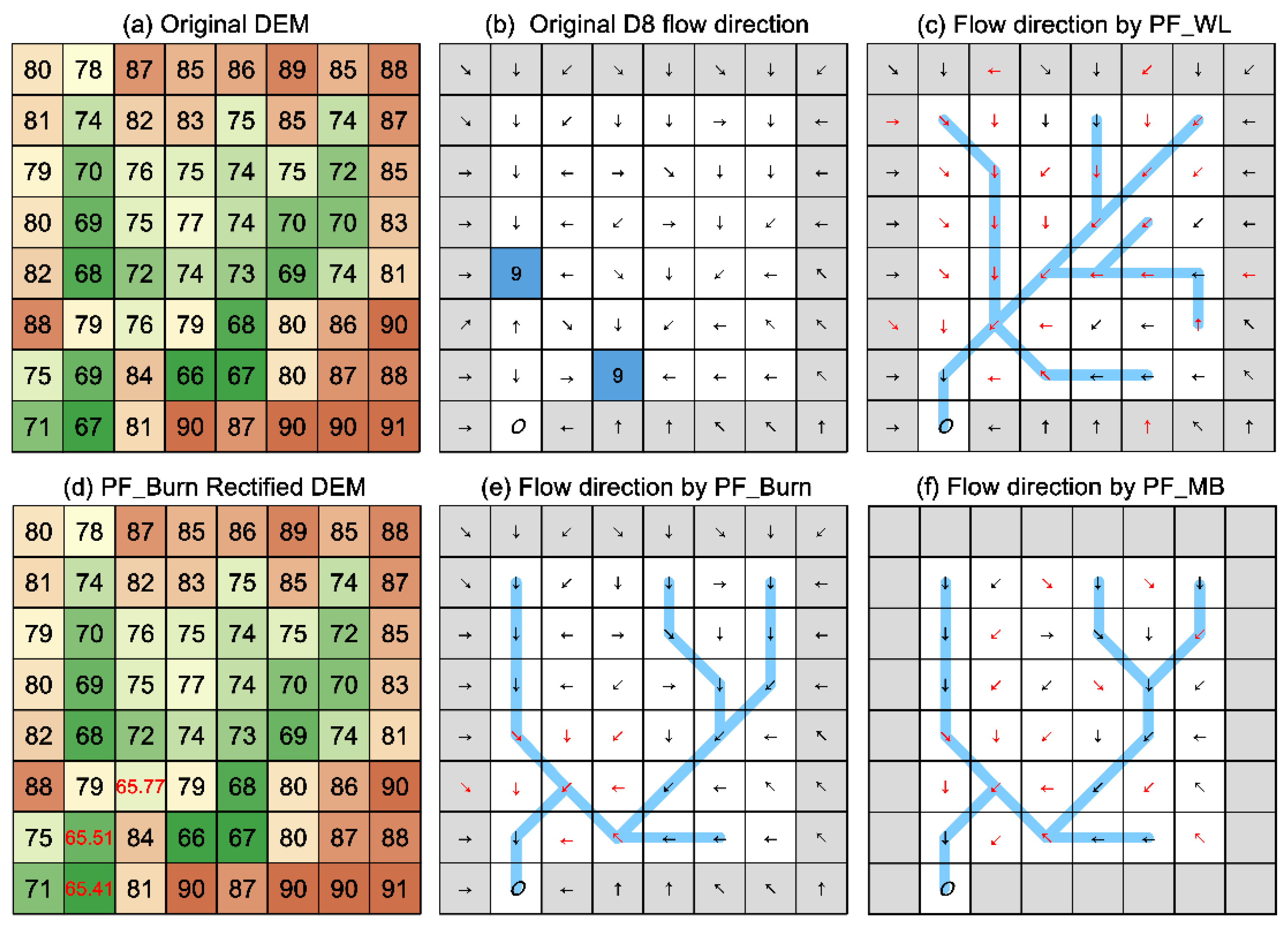
2.1.1. Brief of the Original Algorithm and Its Variant

PF_WL [1] defines spill elevation as the lowest elevation that a pixel needs to be raised by to have a non-ascending path toward the edge of the original DEM. This operation uplifts the elevation of all cells in a depression to the spill elevation of the depression outlet, completely erasing the original elevation information in the depression. Figure 1c shows the flow directions determined by the PF_WL algorithm. The cells superimposed with red-colored arrows, taking up 50% of the total number of cells (including border cells), indicate notable alteration of the original D8 flow directions as shown in Figure 1b. When compared to the original DEM, the pattern of concentrated flow path highlighted as blue segments in Figure 1c is also somewhat changed.
As a variant to PF_WL, rather than modifying the original DEM, PF_MB [10] directs flow from neighbors to focal cell, which leads to their insertions into the priority queue. Using their original elevations as the neighbors’ priority signifies that PF_MB makes use of the original elevation information in a depression. However, for the cells that are not along the path flowing from the depression bottom to the outlet of the depression, their flow directions defined by PF_MB could be different from those determined from the original DEM. This means that the original elevation information in terms of flow direction is not fully used. Importantly, noting that flow direction in this algorithm is defined as the lowest downhill rather than the notional steepest downhill direction. Figure 1f presents the flow directions produced by PF_MB. Cells on the DEM border are not processed in the PF_MB algorithm and therefore do not have flow directions. The cells assigned a red-colored arrow count for 43% of the total number of cells, indicating large modification of the original D8 flow directions (see Figure 1b). Nevertheless, the pattern of concentrated flow path highlighted as blue segments generally coincides with the original DEM.

2.1.2. Brief of the New Variant

As a new variant to PF_WL, PF_Burn redefines spill elevation as the minimum elevation that a pixel needs to be raised by to have a non-ascending path toward the border of the DEM, plus the larger of a minimal positive difference of elevation (operation 1 in Section 2.2) and the difference between the original elevation values of the pixel and its immediate downhill neighboring pixel along the path (operation 2 in Section 2.2). The minimal positive difference of elevation helps to remove depressions and ensure a strict descending flow path. Combining the priority-flood algorithm [3] with this redefinition allows PF_Burn to convert the original DEM to an intermediate elevation surface, which maximally retains the relative heights (see its explanation in Section 2.2) of the original elevation surface. Flow directions derived from the intermediate elevation surface are then used to breach the original DEM. Each breaching starts from a depression bottom and stops until a lower cell or the outlet of the DEM is encountered. Applying the PF_Burn algorithm to the original DEM yields the flow directions and the rectified DEM shown in Figure 1e,d, respectively. The nine cells superimposed with red-arrows in Figure 1e, which occupy 14% of the total area of the sample data, and the three cells labeled with red-colored elevation values in Figure 1d indicate smaller modification of the original elevation information. Overall, for this DEM sample, PF_Burn represents an improvement of PF_WL and PF_MB because it produces a depressionless DEM that maximally retains the original elevation information.

2.2. Implementation of the New Variant

The new variant, PF_Burn, consists of two stages. It first fills depressions using a modified priority-flood algorithm [3] to obtain an intermediate elevation surface SPILL to determine flow directions. Then, following these flow directions, it carves the original elevation surface DEM where necessary. It is, in nature, a breaching algorithm. The pseudo code of PF_Burn is described in Algorithm 1.
Algorithm 1. Priority-flood-based burning (PF_Burn) algorithm
1:    Let DEM be the original elevation surface (i.e., input DEM)
2:    Let SPILL be the intermediate elevation surface after depression filling
3:  Let FlowDirD8 be the output D8 flow directions
4:  Let OPEN be an empty priority queue with total order
5:  Let CLOSED be a matrix of the same sizes as DEM
6:    Calculate FlowDirD8 using DEM, assign the value of 9 for depression bottoms
7:  Initialize CLOSED to false
8:  for all c on the border of DEM
9:       SPILL (c) ← DEM(c)
10:      push c into OPEN with priority DEM(c)
11:      CLOSED(c) ← true
12:    while OPEN is not empty
13:      c ← POP(OPEN)
14:      CLOSED(c) ← true
15:      for all 8-connected neighbors n of c
16:        if CLOSED(n) then repeat the loop
17:        SPILL (n) ← SPILL (c) + max(ε, DEM(n) - DEM(c) )
18:        CLOSED(n) ← true
19:        push n into OPEN with priority DEM(n)
20:    for all c flagged as 9 (i.e., depression bottom) in FlowDirD8
21:      DEM(c) ← min(elevations of the 8 neighbors of c in DEM)
22:      n ← the neighbor of c with the steepest slope (calculated in SPILL)
23:    while DEM(c) ≤ DEM(n)
24:         DEM(n) ← DEM(c)ε
25:         FlowDirD8(c) points from c to n
26:         c = n
27:         n ← the neighbor of c with the steepest slope (calculated in SPILL)
In the first stage, a descending flow path from neighboring cells n to the center cell c is acquired by applying one of the two operations to all unprocessed neighbors n of the cell c popped from the priority queue and pushing the neighbors into the priority queue using their unaltered elevations as their priorities:
d i f f n c 0 S P I L L ( n ) = S P I L L ( c ) + ε
d i f f n c > 0 S P I L L ( n ) = S P I L L ( c ) + d i f f n c
where d i f f n c = D E M ( n ) D E M ( c ) is the relative heights between the cells of n and c. Similar to [2,4], we set the minimal positive difference of elevation ε herein to be 0.001 multiplied by the ratio of the distance between n and c to the cell size of DEM.
A negative relative height indicates that water from the neighbor n cannot flow to c according to the original DEM. Given that cell c, popped from the priority queue, is the lowest downstream cell of n, the spill elevation of n has to be raised to modify its flow direction. A positive relative height represents that water from the neighbor n can at least, but not necessarily, flow to c according to the original DEM. In this circumstance, the original flow direction of n does not need to be altered, and an approach to maintain the original flow direction could be to retain the relative height information from the original DEM in the raster of spill elevation. Apparently, after the operations of (1) and (2), the resulting intermediate elevation surface SPILL retained all the positive relative height information in the original elevation surface. This allows the calculation of flow directions that maximally reflect the flow directions determined form the original elevation surface, while guaranteeing continuous flow paths from basin divides to outlets.
In the second stage, the D8 flow direction for each cell is calculated using the original elevation surface DEM and stored in the matrix FlowDirD8. Depression bottom cells are assigned values of 9 in FlowDirD8. Starting from each depression bottom, the original elevation surface DEM is breached by tracking the flow directions calculated from the intermediate elevation surface SPILL. Each breaching propagated until a downhill cell is also guaranteed in the original elevation surface DEM. Along with the breaching process, the flow directions of the associated cells in FlowDirD8 are also updated.
At the beginning of the process, DEM stores the original elevation of each cell (including NODATA value). At the exit, (1) DEM stores the rectified elevation (if necessary) of each cell (including NODATA value). (2) The elevations of DEM are such that each cell will drain continuously across a digital landscape. (3) FlowDirD8 stores the D8 flow direction of each cell (including NODATA value). (4) The flow directions of FlowDirD8 are such that each cell will drain continuously towards the DEM border.

3. A Test Using a Complex Terrain Data

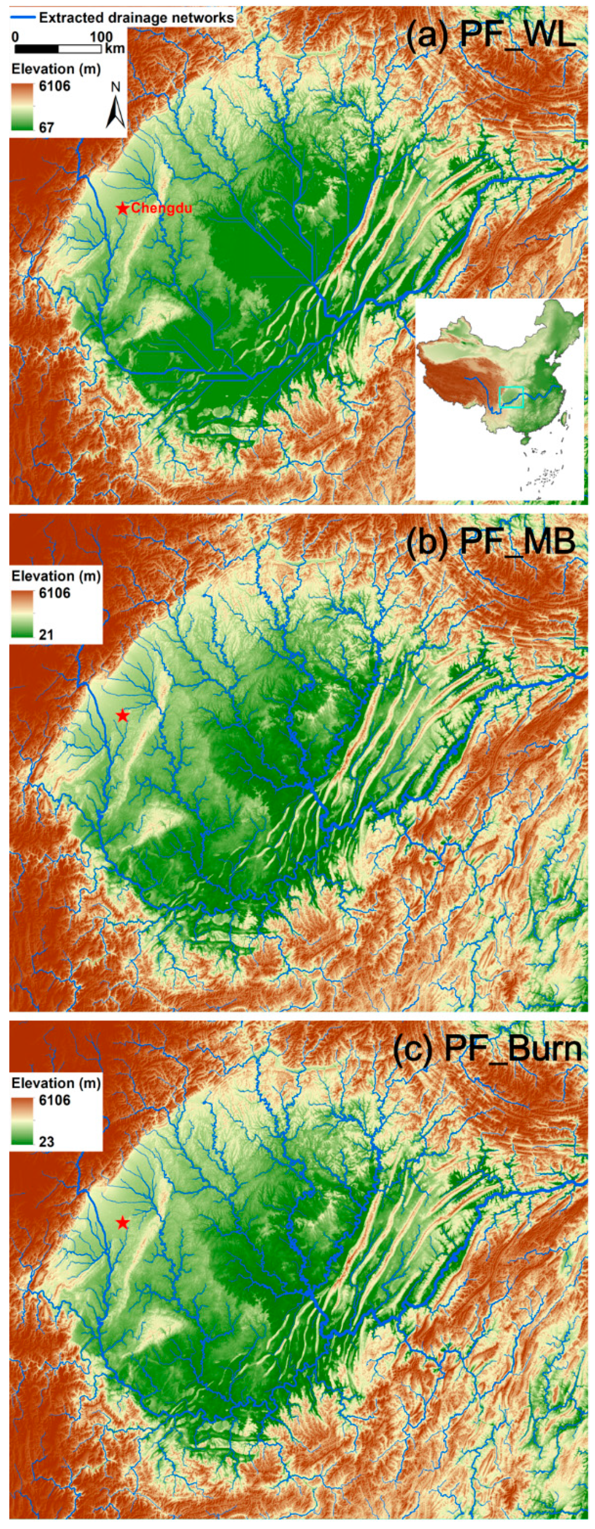
3.1. Study Area and Data

The PF_WL, PF_MB, and PF_Burn algorithms were tested using a complex terrain of a region that encloses the Sichuan Basin in Southwestern China (Figure 2). The Sichuan Basin covers 260,000 km2 and is a structural basin, i.e., a large geological depression surrounded by the Tibetan Plateau in the west, the Yunnan–Guizhou Plateau in the south, the Wu Mountains in the east, and the Daba Mountains in the north. Within the basin, the land surface is comprised of flat alluvial fans in the northwest, rolling hills in the center, mountains in the northernmost and southwest, and fold-and-valley terrain in the easternmost. The Sichuan Basin is drained by the upper reach of the Yangtze River and its tributaries. We also applied the new variant to the 90 m resolution SRTM DEM to extract river networks of the contiguous China and found it effective and efficient in depression treatment.
The 3 arc-second (approximately 90 m) SRTM DEM of the rectangular test region has a size of about 6300 × 7600 cells, covering an area of about 380,000 km2. The DEM does not contain NODATA value and has ~1.1 million depression bottoms, occupying 2.40% of its total area. The elevation varies from 20 to 6100 m. This DEM was used to test the three algorithms on the same laptop. Using the flow directions determined by each algorithm, flow accumulations were calculated. Knowing its limitation but for illustration purpose, the same flow accumulation threshold of about 10 km2 was applied to extract drainage networks. The rich topographic characteristics, large spatial extent, and notable portion of depression bottoms make the Sichuan Basin a unique area to test depression treatment algorithms.

3.2. Application of the New Variant

The test on the complex terrain data indicates that PF_Burn represents an improvement over PF_WL and PF_MB in treating depressions, with reduced alteration of the original elevation information while the high computational efficiency maintained. Figure 2a shows the major drainage networks and the depression-filled DEM obtained based on the PF_WL algorithm. Figure 2b plots the major drainage networks derived based on PF_MB, also overlaid is the original elevation surface. Figure 2c displays the major drainage network and rectified DEM based on PF_Burn, the new variant. Considering the extracted drainage network, while the one obtained based on PF_WL seems unrealistic—there are few parallel rivers—those obtained from PF_MB and PF_Burn are almost identical and coincide well with the original terrain. Regarding elevation values, while PF_MB did not alter the original DEM, PF_WL and PF_Burn modified 20.34% and 4.95% of the original elevation values, respectively. Concerning flow directions, PF_WL, PF_MB, and PF_Burn altered 20.48%, 41.27%, and 3.41% of the D8 steepest downslope flow directions calculated using the original elevation surface, respectively. PF_MB modified the original flow directions most because it did not adopt the notional definition of flow direction as the D8 steepest downslope. The processing times of PF_WL, PF_MB, and PF_Burn were comparable, with a ratio of 1:1.16:1.21.

4. Conclusions and Discussion

In this work, a variant of Wang and Liu’s [1] algorithm for topographic depression treatment was proposed. The new variant (1) redefines “spill elevation” as the lowest elevation that a cell needed to be raised by to drain toward the edge of the DEM, plus the larger of a small positive number and a relative height, which is the difference between the original elevation values of a focal cell and its immediate downstream pixel. (2) Combines this redefinition with the priority-flood algorithm [3] to generate an intermediate elevation surface to calculate flow directions; and (3) uses theses flow directions to breach the original DEM to remove depressions. Comparisons between the new variant, the original Wang and Liu [1] algorithm, and its variant described by Metz et al. [10] using a DEM of a large structural basin with complex terrain showed that the new variant tended to be most capable to retain the elevation information of the original DEM and computationally as efficient as the other two. The enhanced depression treatment algorithm developed in this study is provided as a freely-available tool BNUSinkRemv (see supplements of the online paper).
The breaching algorithm presented in this work originated from a depression filling algorithm and turned out to be advantageous. First, the new algorithm, when tested together with the Wang and Liu [1] algorithm and the variant of the priority-flood-based algorithm described by Metz et al. [10] on a DEM of a large structural basin with complex terrain, avoided introducing flat areas into the DEM and made a notable smaller amount of modifications to the original elevation information. This is attractive in the sense that it impacts the topography-based hydrologic analysis to a lesser extent [4,22,27]. Second, the new algorithm had a comparable computational efficiency to the original filling algorithms [1]. Filling algorithms have been prevalent in practices due to their long history, wide availability and high computational efficiency [7,16,17], and therefore being not too slow is another important factor for a breaching algorithm to gain popularity [7] in the era of high-resolution DEMs. Lastly, the new algorithm helped to extract realistic (or accurate) river networks, which is the goal and basis of many hydrologic studies [4,7,19]. These advantages make the new variant capable of producing depressionless DEMs with small modification and high resolution. This is important because most hydrologic analysis and modeling studies require not only realistic drainage networks but also refined DEMs. For example, we are developing a consistent approach for extracting drainage networks, assigning hydrologic unit code, and calculating height above nearest drainage (HAND) [14,28] for China on a 3 arc-second (approximately 90 m) SRTM DEM. HAND is a hydrologic variable that can be used as a new proxy predictor of inundation extent [29,30]. In this process, we encountered the parallel streams problem in some regions of China (e.g., the large structural Sichuan Basin exemplified herein) when adopting the Wang and Liu algorithm [1] for depression treatment, which led to the development of the new variant presented in this study. We believe our new variant of the priority-flood-based algorithm will help us to obtain more realistic drainage networks and produce improved HAND results.
Topographic analysis plays important roles in understanding hydrologic, geographical and environment processes [7]. The natural or artificial depressions embraced in topographic data hinder the analyses of flow paths, drainage area, topographic indices, wetness indices, river morphology, and others, and therefore have been recognized as a critical step in topographic analysis. Complementary to the depression treatment by adopting the more sophisticated flow direction determination algorithms [31,32] or full-scale hydrodynamic models [33,34,35], the enhanced variant proposed in this study for depression removal via carving adopts the simplest D8 flow direction determination approach and is helpful for producing depressionless DEMs and extracting realistic river networks with small effort.

Supplementary Materials

The following are available online at https://www.mdpi.com/article/10.3390/w13233347/s1.

Author Contributions

Conceptualization, B.C. and J.Z.; methodology, C.M., B.C. and J.Z.; software, Y.X., C.M. and H.G.; validation, C.M. and Yoa Xiao; formal analysis, B.C., J.Z. and P.S.; investigation, C.M. and J.Z.; resources, B.C. and J.Z.; data curation, C.M., Y.X. and H.G.; writing—original draft preparation, B.C.; writing—review and editing, J.Z. and P.S.; visualization, C.M. and B.C.; supervision, B.C. and J.Z.; project administration, B.C. and J.Z.; funding acquisition, B.C. and J.Z.; All authors have read and agreed to the published version of the manuscript.

Funding

This work was conducted with the financial support jointly provided by the USFS-UNC Joint Venture Agreement [16-JV-11330155-058], the key research project of Guangdong Meteorological Service [GRMC2019Z01], the Director General Scientific Research Fund of National Disaster Re-duction Center of China [202028ZZ00], and the Project of the National Natural Science Foundation of China (Grant No. 41501020).

Institutional Review Board Statement

Not applicable.

Informed Consent Statement

Not applicable.

Data Availability Statement

Not applicable.

Acknowledgments

We thank our editors and anonymous professionals for their valuable suggestions which greatly helped us to improve the quality of this work.

Conflicts of Interest

The authors declare no conflict of interest.

References

  1. Wang, L.; Liu, H. An Efficient Method for Identifying and Filling Surface Depressions in Digital Elevation Models for Hydrologic Analysis and Modelling. Int. J. Geogr. Inf. Sci. 2006, 20, 193–213. [Google Scholar] [CrossRef]
  2. Planchon, O.; Darboux, F. A Fast, Simple and Versatile Algorithm to Fill the Depressions of Digital Elevation Models. Catena 2001, 46, 159–176. [Google Scholar] [CrossRef]
  3. Barnes, R.; Lehman, C.; Mulla, D. Priority-Flood: An Optimal Depression-Filling and Watershed-Labeling Algorithm for Digital Elevation Models. Comput. Geosci. 2014, 62, 117–127. [Google Scholar] [CrossRef] [Green Version]
  4. Lidberg, W.; Nilsson, M.; Lundmark, T.; Ågren, A.M. Evaluating Preprocessing Methods of Digital Elevation Models for Hydrological Modelling. Hydrol. Process. 2017, 31, 4660–4668. [Google Scholar] [CrossRef] [Green Version]
  5. Marks, D.; Dozier, J.; Frew, J. Automated Basin Delineation from Digital Terrain Data. Geo-Processing 1983, 2, 299–311. [Google Scholar]
  6. Soille, P.; Vogt, J.; Colombo, R. Carving and Adaptive Drainage Enforcement of Grid Digital Elevation Models. Water Resour. Res. 2003, 39, 1366. [Google Scholar] [CrossRef]
  7. Lindsay, J.B. Efficient Hybrid Breaching-Filling Sink Removal Methods for Flow Path Enforcement in Digital Elevation Models. Hydrol. Process. 2015, 30, 846–857. [Google Scholar] [CrossRef]
  8. Beven, K.J.; Kirkby, M.J. A Physically Based, Variable Contributing Area Model of Basin Hydrology/Un Modèle à Base Physique De Zone D’appel Variable De L’hydrologie Du Bassin Versant. Hydrol. Sci. Bull. 1979, 24, 43–69. [Google Scholar] [CrossRef] [Green Version]
  9. Yan, Y.; Tang, J.; Pilesjö, P. A Combined Algorithm for Automated Drainage Network Extraction from Digital Elevation Models. Hydrol. Process. 2018, 32, 1322–1333. [Google Scholar] [CrossRef]
  10. Metz, M.; Mitasova, H.; Harmon, R.S. Efficient Extraction of Drainage Networks from Massive, Radar-Based Elevation Models with Least Cost Path Search. Hydrol. Earth Syst. Sci. 2011, 15, 667–678. [Google Scholar] [CrossRef] [Green Version]
  11. Jenson, S.K.; Domingue, J.O. Extracting Topographic Structure from Digital Elevation Data for Geographic Information-System Analysis. Photogramm. Eng. Remote Sens. 1988, 54, 1593–1600. [Google Scholar]
  12. Pan, F.; Stieglitz, M.; McKane, R.B. An Algorithm for Treating Flat Areas and Depressions in Digital Elevation Models Using Linear Interpolation. Water Resour. Res. 2012, 48, W00L10. [Google Scholar] [CrossRef] [Green Version]
  13. Zhang, H.; Yao, Z.; Yang, Q.; Li, S.; Baartman, J.E.M.; Gai, L.; Yao, M.; Yang, X.; Ritsema, C.J.; Geissen, V. An Integrated Algorithm to Evaluate Flow Direction and Flow Accumulation in Flat Regions of Hydrologically Corrected Dems. Catena 2017, 151, 174–181. [Google Scholar] [CrossRef]
  14. Rennó, C.D.; Nobre, A.D.; Cuartas, L.A.; Soares, J.V.; Hodnett, M.G.; Tomasella, J.; Waterloo, M.J. Hand, a New Terrain Descriptor Using Srtm-Dem: Mapping Terra-Firme Rainforest Environments in Amazonia. Remote Sens. Environ. 2008, 112, 3469–3481. [Google Scholar] [CrossRef]
  15. Barnes, R. Parallel Priority-Flood Depression Filling for Trillion Cell Digital Elevation Models on Desktops or Clusters. Comput. Geosci. 2016, 96, 56–68. [Google Scholar] [CrossRef] [Green Version]
  16. Zhou, G.; Sun, Z.; Fu, S. An Efficient Variant of the Priority-Flood Algorithm for Filling Depressions in Raster Digital Elevation Models. Comput. Geosci. 2016, 90, 87–96. [Google Scholar] [CrossRef]
  17. Wei, H.; Zhou, G.; Fu, S. Efficient Priority-Flood Depression Filling in Raster Digital Elevation Models. Int. J. Digit. Earth 2019, 12, 415–427. [Google Scholar] [CrossRef]
  18. Soille, P.; Vincent, L. Watersheds in Digital Spaces: An Efficient Algorithm Based on Immersion Simulations. IEEE Trans. Pattern Anal. Mach. Intell. 1991, 13, 583–598. [Google Scholar]
  19. Soille, P.; Gratin, C. An Efficient Algorithm for Drainage Network Extraction on Dems. J. Vis. Commun. Image Represent. 1994, 5, 181–189. [Google Scholar] [CrossRef]
  20. Zhou, G.; Zhou, J.; Li, Y. Filling Depressions Based on Sub-Watersheds in Raster Digital Elevation Models. In Proceedings of the Paper Presented at the 2017 IEEE International Geoscience and Remote Sensing Symposium (IGARSS), Fort Worth, TX, USA, 23–28 July 2017. [Google Scholar]
  21. Xiong, L.-Y.; Jiang, R.-Q.; Lu, Q.-H.; Yang, B.-S.; Li, F.-Y.; Tang, G.-A. Improved Priority-Flood Method for Depression Filling by Redundant Calculation Optimization in Local Micro-Relief Areas. Trans. GIS 2019, 23, 259–274. [Google Scholar] [CrossRef]
  22. Lindsay, J.B.; Creed, I.F. Removal of Artifact Depressions from Digital Elevation Models: Towards a Minimum Impact Approach. Hydrol. Process. 2005, 19, 3113–3126. [Google Scholar] [CrossRef]
  23. Wang, Y.-J.; Qin, C.-Z.; Zhu, A.X. Review on Algorithms of Dealing with Depressions in Grid Dem. Ann. GIS 2019, 25, 83–97. [Google Scholar] [CrossRef] [Green Version]
  24. Wolock, D.M.; McCabe, G.J., Jr. Comparison of Single and Multiple Flow Direction Algorithms for Computing Topographic Parameters in Topmodel. Water Resour. Res. 1995, 31, 1315–1324. [Google Scholar] [CrossRef]
  25. Quinn, P.; Beven, K.; Chevallier, P.; Planchon, O. The Prediction of Hillslope Flow Paths for Distributed Hydrological Modelling Using Digital Terrain Models. Hydrol. Process. 1991, 5, 59–79. [Google Scholar] [CrossRef]
  26. Tarboton, D.G. A New Method for the Determination of Flow Directions and Upslope Areas in Grid Digital Elevation Models. Water Resour. Res. 1997, 33, 309–319. [Google Scholar] [CrossRef] [Green Version]
  27. Soille, P. Optimal Removal of Spurious Pits in Grid Digital Elevation Models. Water Resour. Res. 2004, 40, 1–9. [Google Scholar] [CrossRef] [Green Version]
  28. Nobre, A.D.; Cuartas, L.A.; Hodnett, M.; Rennó, C.D.; Rodrigues, G.; Silveira, A.; Waterloo, M.; Saleska, S. Height above the Nearest Drainage—A Hydrologically Relevant New Terrain Model. J. Hydrol. 2011, 404, 13–29. [Google Scholar] [CrossRef] [Green Version]
  29. Nobre, A.D.; Cuartas, L.A.; Momo, M.R.; Severo, D.L.; Pinheiro, A.; Nobre, C.A. Hand Contour: A New Proxy Predictor of Inundation Extent. Hydrol. Process. 2016, 30, 320–333. [Google Scholar] [CrossRef]
  30. Liu, Y.; Maidment, D.; Tarboton, D.; Zheng, X.; Yildirim, A.A.; Sazib, N.; Wang, S. A Cybergis Approach to Generating High-Resolution Height above Nearest Drainage (Hand) Raster for National Flood Mapping. In Proceedings of the Paper Presented at the International Conference on Cybergis and Geospatial Data Science 2016, Urbana, IL, USA, 24 June 2016. [Google Scholar]
  31. Orlandini, S.; Moretti, G. Determination of Surface Flow Paths from Gridded Elevation Data. Water Resour. Res. 2009, 45, 1–14. [Google Scholar] [CrossRef] [Green Version]
  32. Shin, S.; Paik, K. An Improved Method for Single Flow Direction Calculation in Grid Digital Elevation Models. Hydrol. Process. 2017, 31, 1650–1661. [Google Scholar] [CrossRef]
  33. Costabile, P.; Costanzo, C. A 2d-Swes Framework for Efficient Catchment-Scale Simulations: Hydrodynamic Scaling Properties of River Networks and Implications for Non-Uniform Grids Generation. J. Hydrol. 2021, 599, 126306. [Google Scholar] [CrossRef]
  34. Xia, X.; Liang, Q.; Ming, X. A Full-Scale Fluvial Flood Modelling Framework Based on a High-Performance Integrated Hydrodynamic Modelling System (Hipims). Adv. Water Resour. 2019, 132, 103392. [Google Scholar] [CrossRef]
  35. Nguyen, P.; Thorstensen, A.; Sorooshian, S.; Hsu, K.; AghaKouchak, A.; Sanders, B.; Koren, V.; Cui, Z.; Smith, M. A High Resolution Coupled Hydrologic–Hydraulic Model (Hiresflood-Uci) for Flash Flood Modeling. J. Hydrol. 2016, 541, 401–420. [Google Scholar] [CrossRef] [Green Version]
Figure 1. Illustration of various depression treatments. (a) An 8 × 8 sample extracted from a 90-m DEM of the Sichuan Basin, which is the study area (see Section 3.1), and its associated D8 steepest downhill flow directions (b). (c) Flow directions determined by the PF_WL algorithm. (d) Depressionless DEM produced by PF_Burn algorithm (the new variant). Flow directions determined by the PF_Burn (e) and the PF_MB (f) algorithms. Red-colored arrows indicate alterations of the original D8 flow directions as shown in Figure 1b. The dark-shaded cells are border cells.
Water 13 03347 g001
Figure 2. Comparison of the drainage networks derived based on the three depression treatments, overlaid with three different 90 m DEMs of the test region that encloses the Sichuan Basin, Southwestern China. (a) The major drainage networks and the depression-filled DEM obtained based on the PF_WL algorithm. The inset in the lower-right corner shows the topography of China, the Yangtze River, and the box that bounds the test region. (b) The major drainage networks derived based on PF_MB and the original DEM. (c) The major drainage networks and rectified DEM based on PF_Burn.
Water 13 03347 g002
Publisher’s Note: MDPI stays neutral with regard to jurisdictional claims in published maps and institutional affiliations.

