
Water Quality Index (WQI) as a Potential Proxy for Remote Sensing Evaluation of Water Quality in Arid Areas


 ,
, 
 ,
, 
 ,
,
Abstract
:1. Introduction
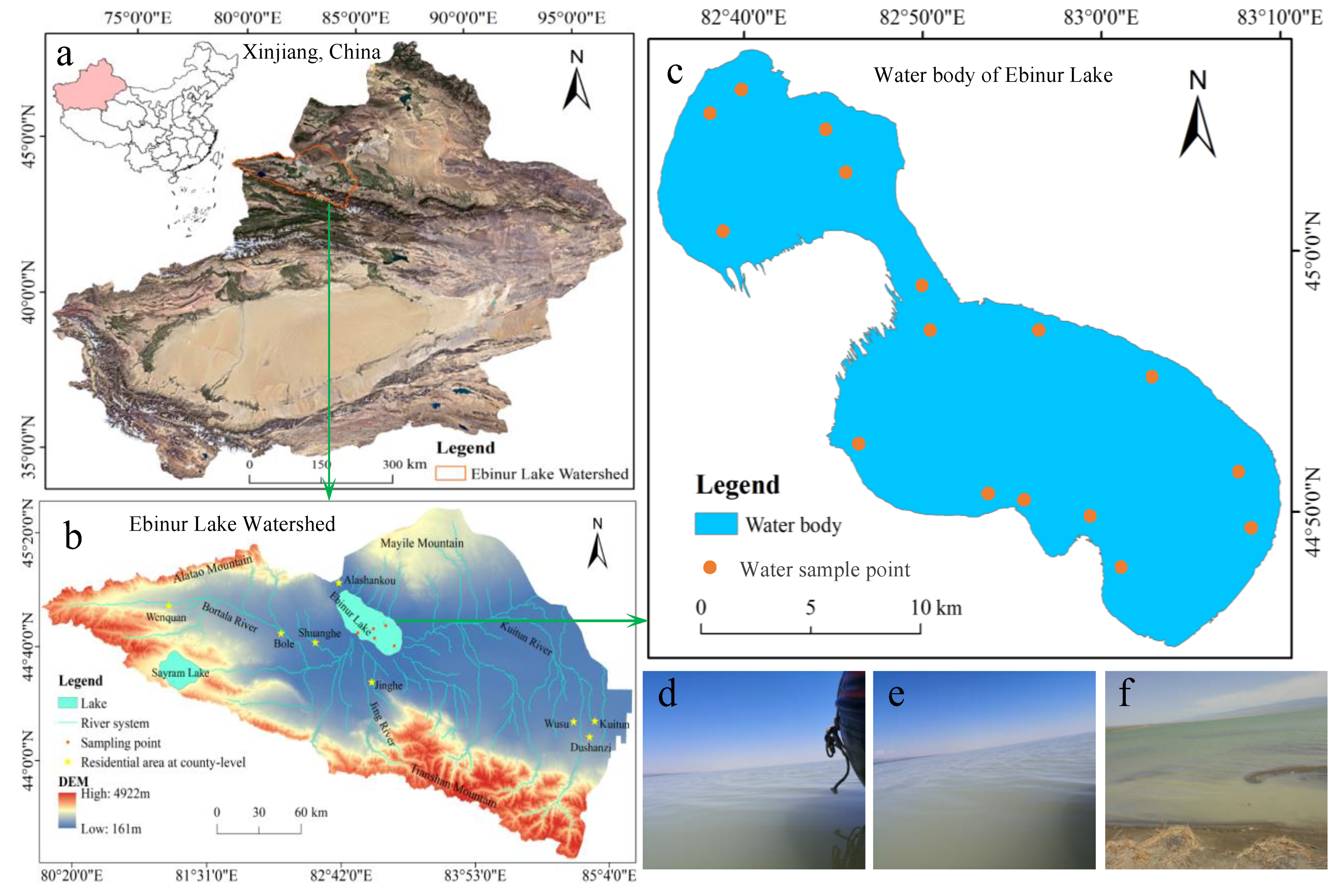
2. Study Area
3. Data and Methods
3.1. Data Collection
Water Quality Data Collection
3.2. Remote Sensing Data Collection
3.3. Methods
3.3.1. Construction of Spectral Index
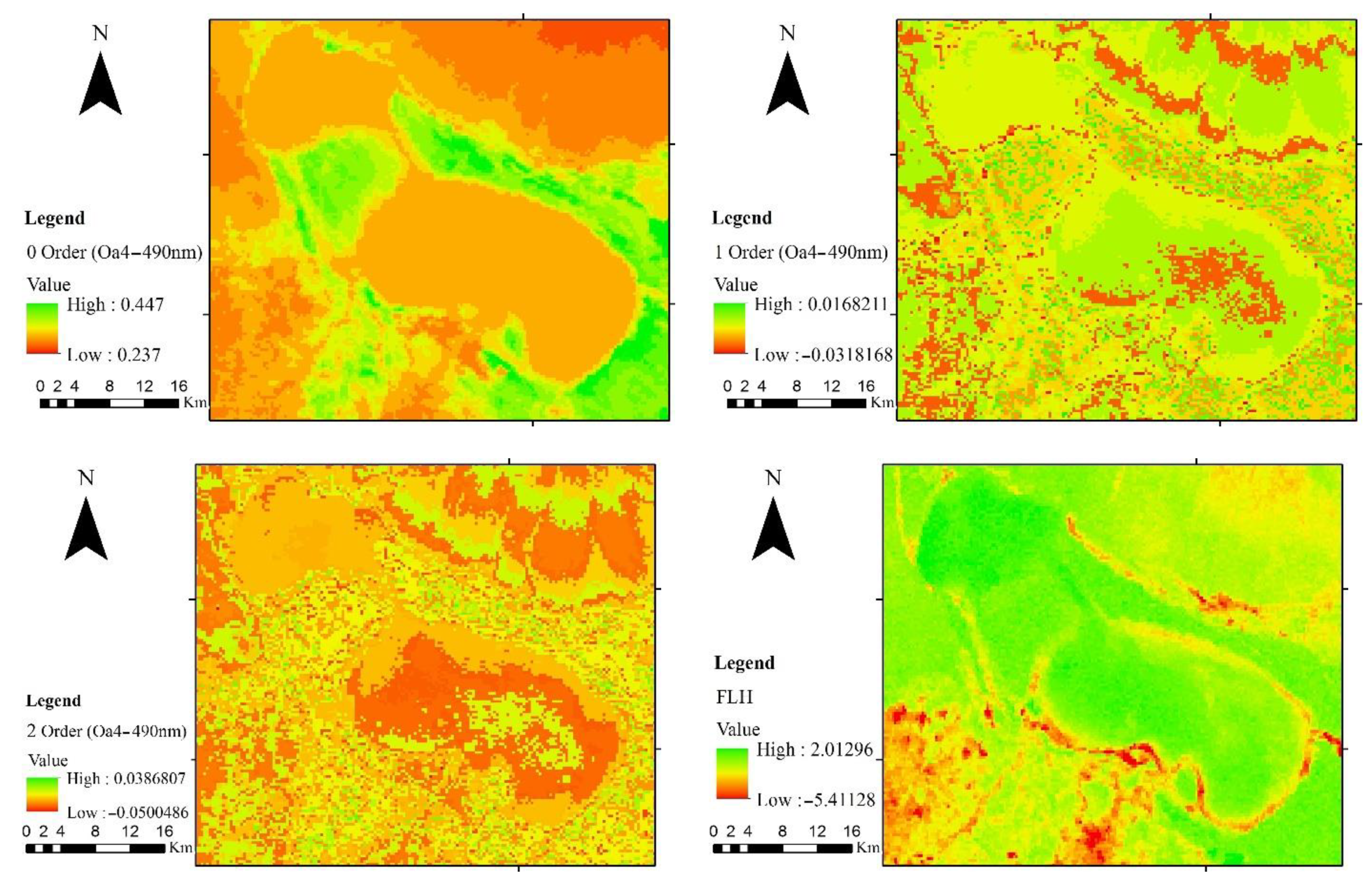
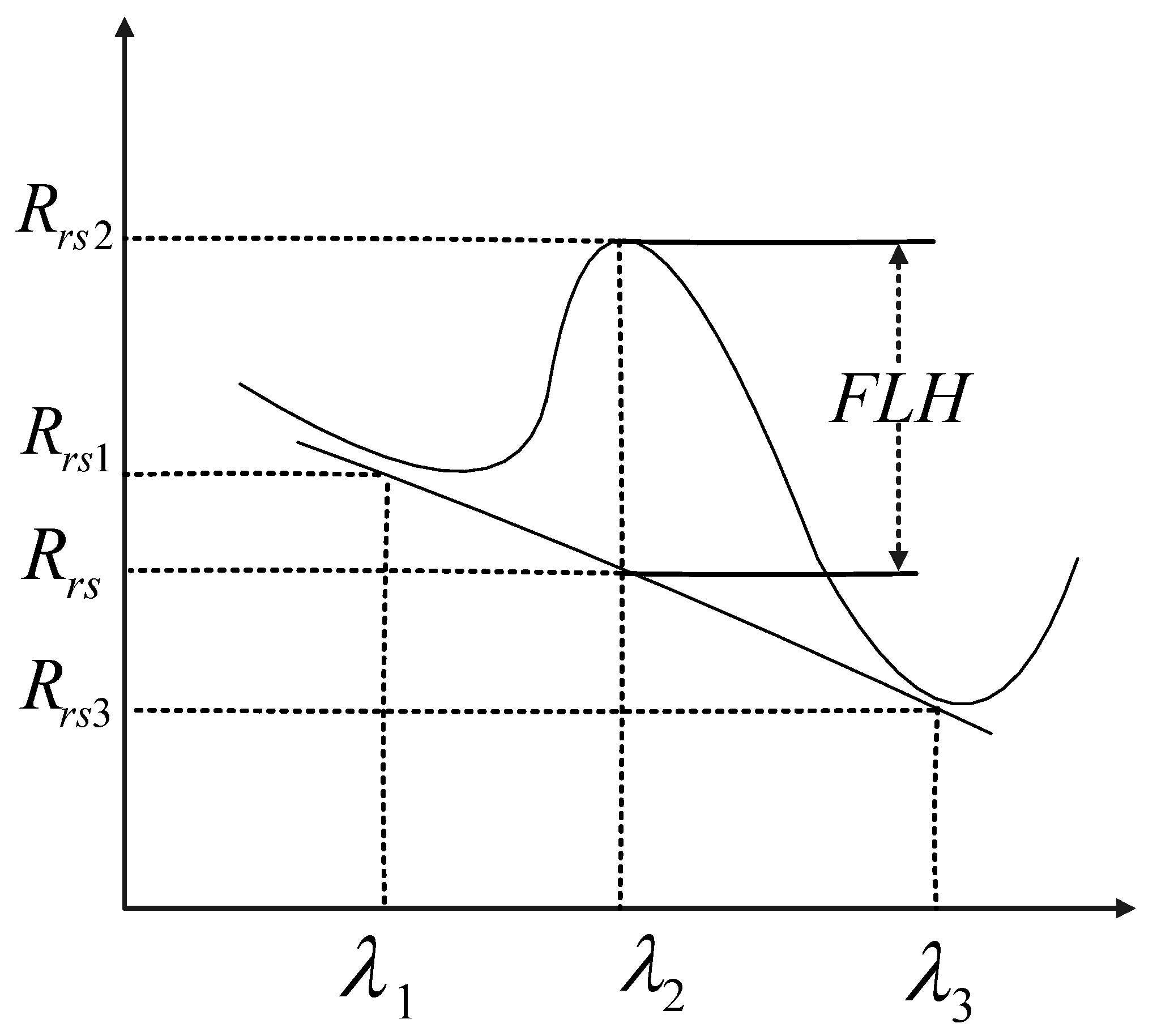
3.3.2. Fluorescence Line Height
3.3.3. Water Quality Index (WQI)
3.3.4. SVM Model
3.3.5. Estimate the Evaluation Index of the Model
4. Results and Analysis
4.1. Analysis of Spatial Variation Trend of WQI
4.2. Study on Reflectance Spectral Characteristics of Water in Ebinur Lake
4.2.1. Spectral Characteristics of Water Based on Sentinel 3 Data
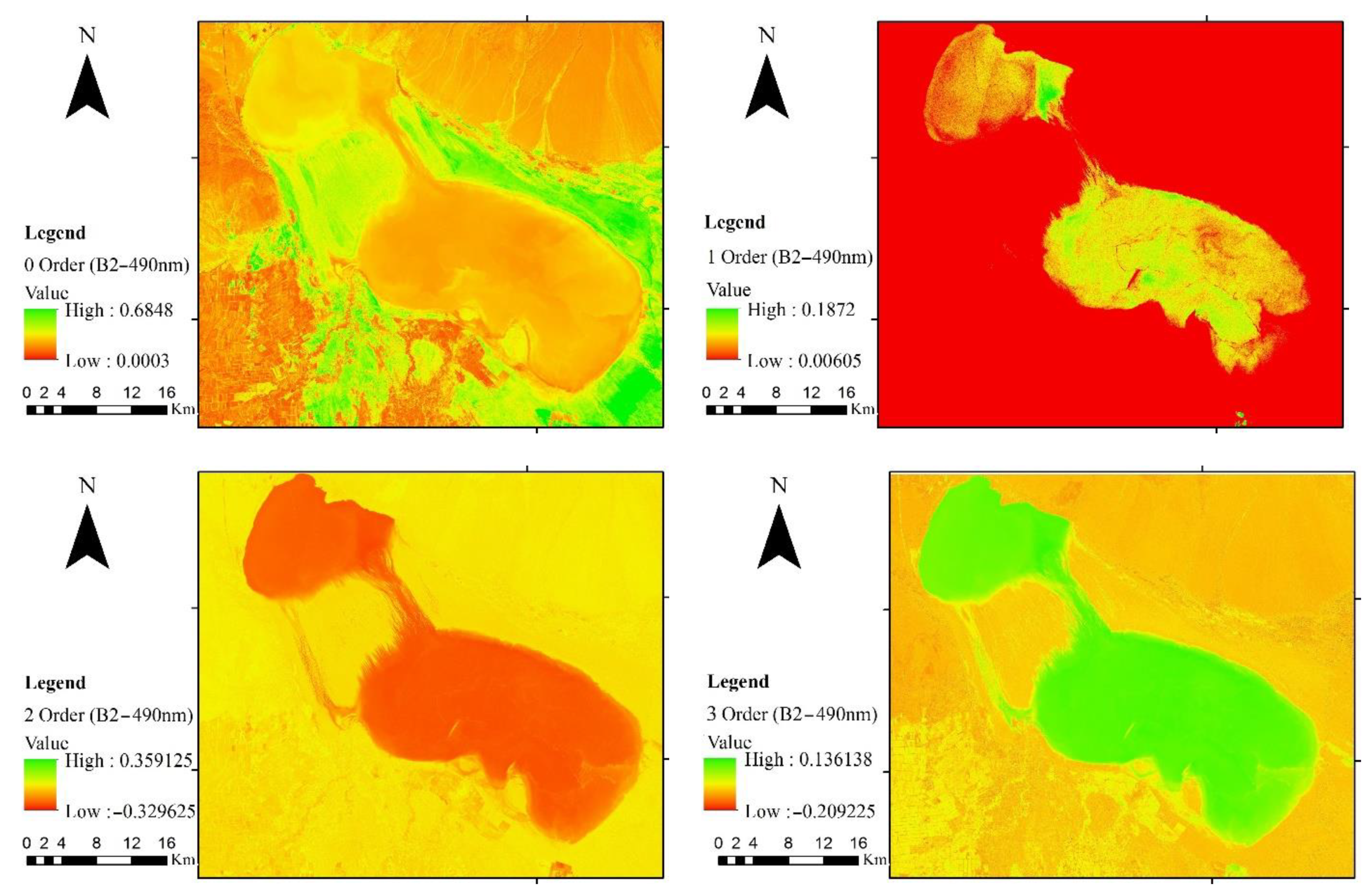
4.2.2. Spectral Characteristics of Water Based on Sentinel 2 Data
4.3. Relationship between Spectral Parameters and WQI
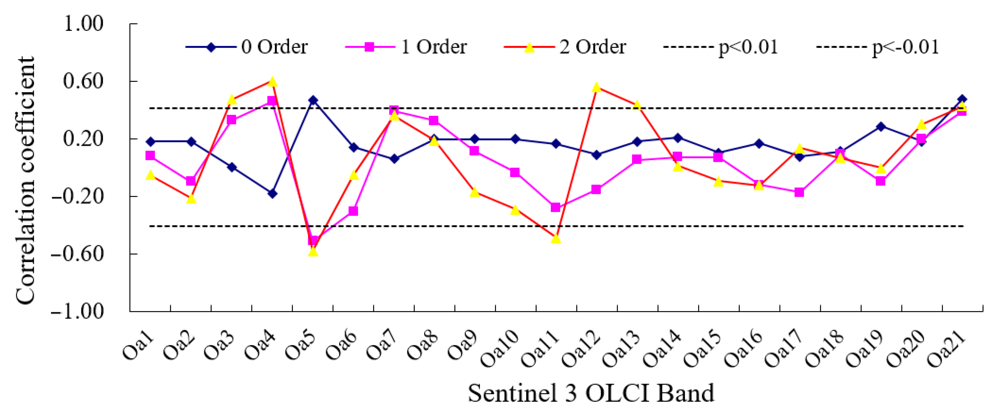
4.3.1. Relationship between WQI and Spectral Parameters from Sentinel 3 Data
- (1)
- Relationship between Single Band Reflectance and WQI
- (2)
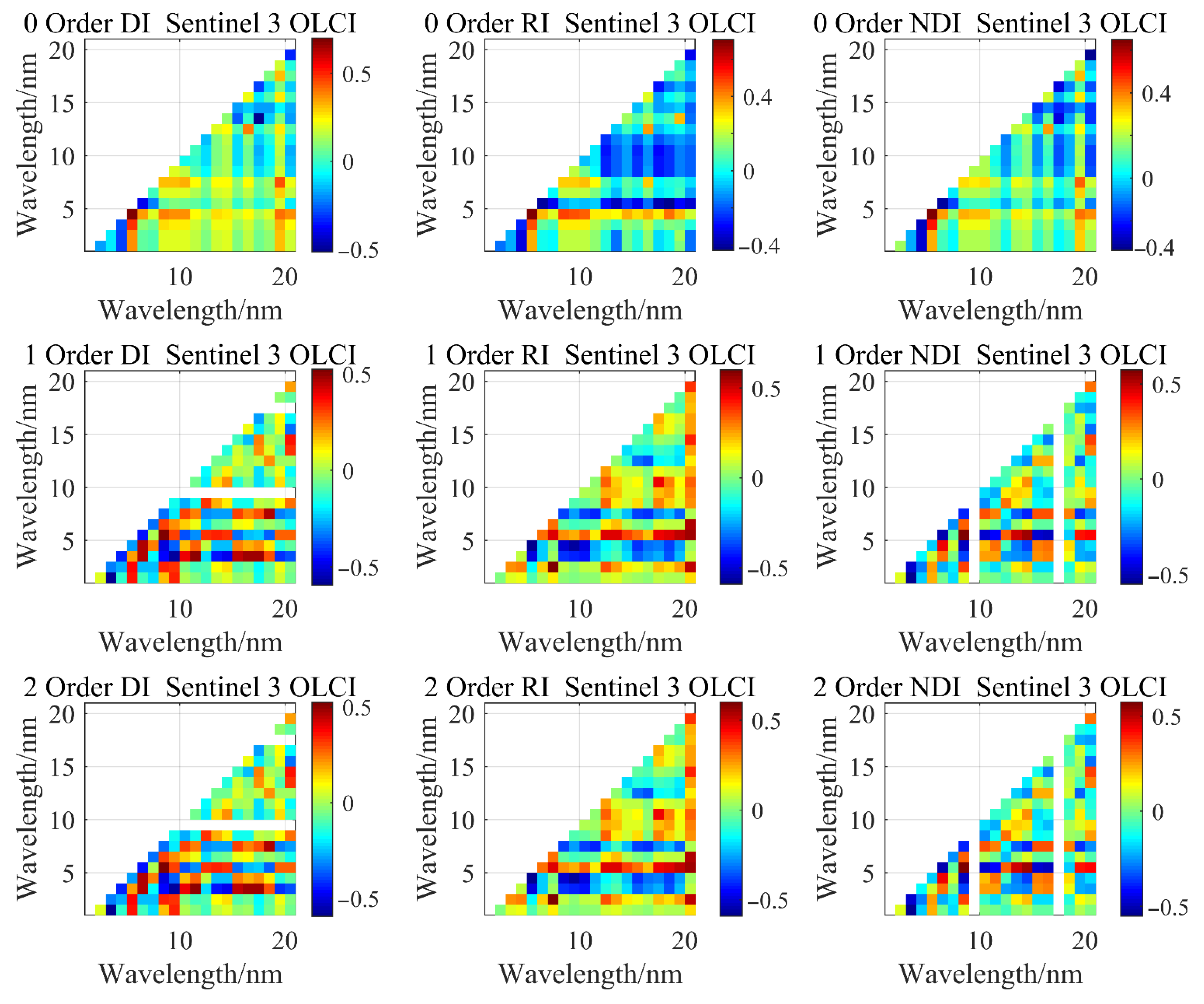
- Relationship between spectral index from Sentinel 3 data and WQI
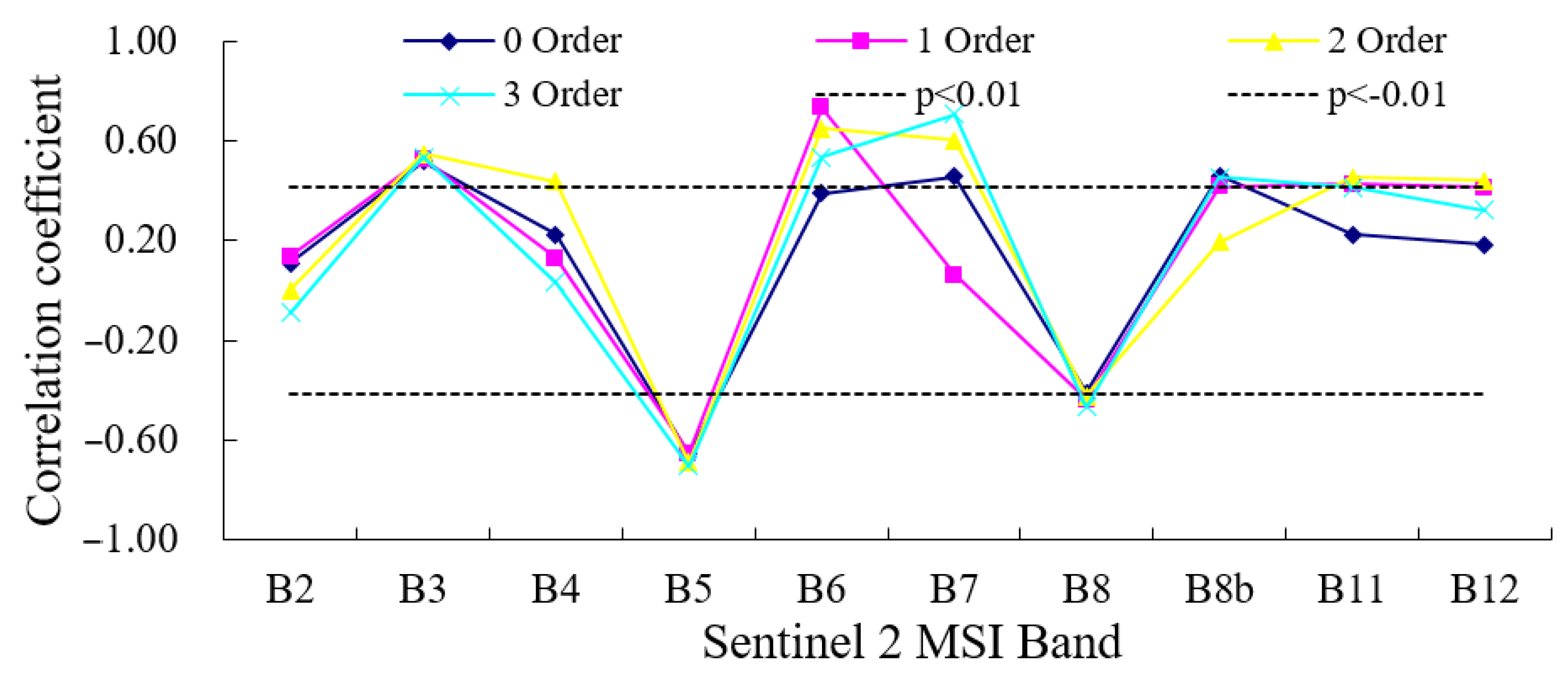
4.3.2. Relationship between WQI and Spectral Parameters from Sentinel 2 Data
- (1)
- Relationship between single band reflectance and WQI
- (2)
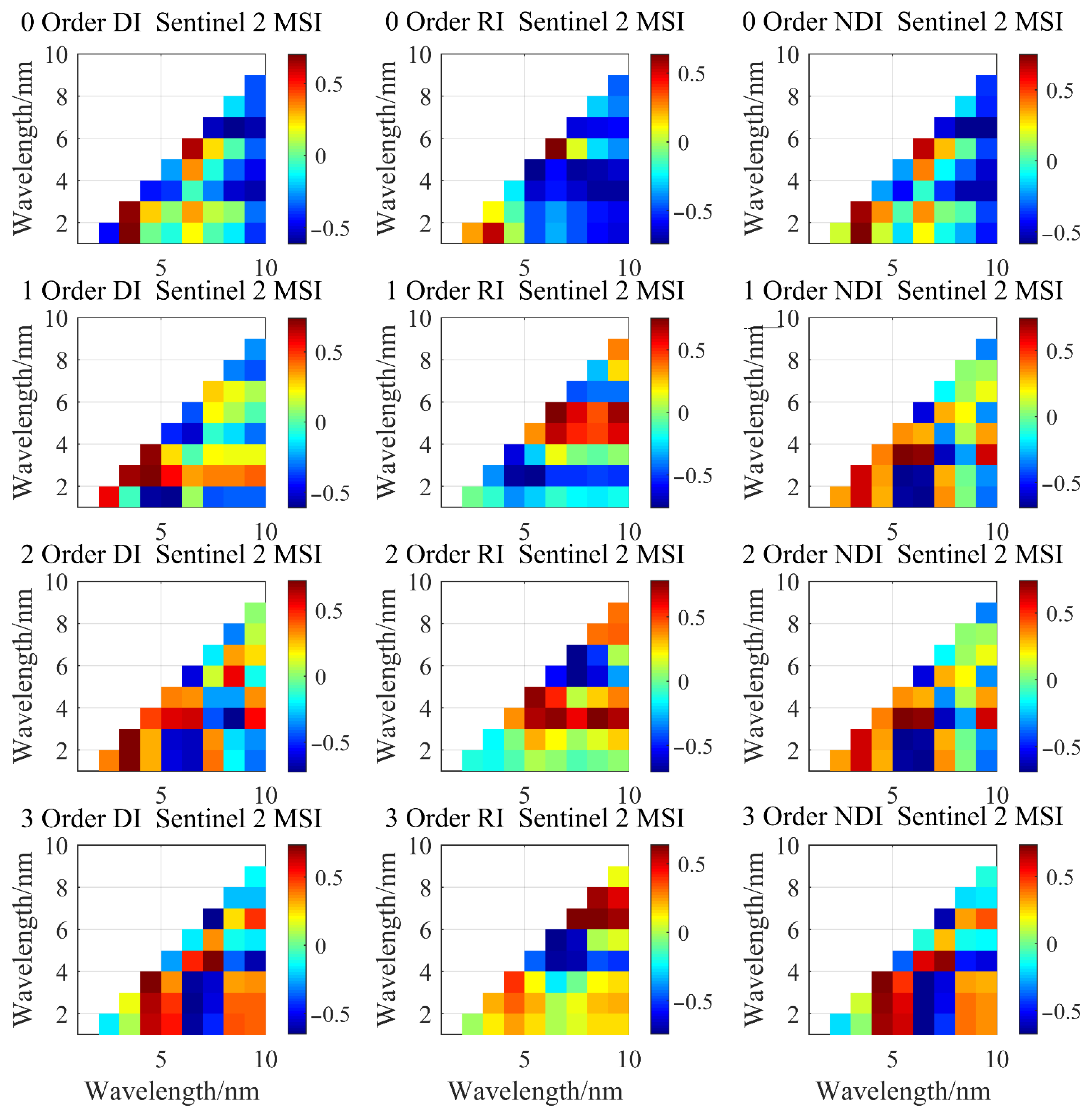
- Relationship between Spectral Index of Sentinel 2 Data and WQI
4.4. Verification and Precision Analysis of Water Quality Estimation Model
4.4.1. Validation of WQI Estimation Model by Sentinel 2 Data
4.4.2. Validation of WQI Estimation Model Supported by Sentinel 3 Data
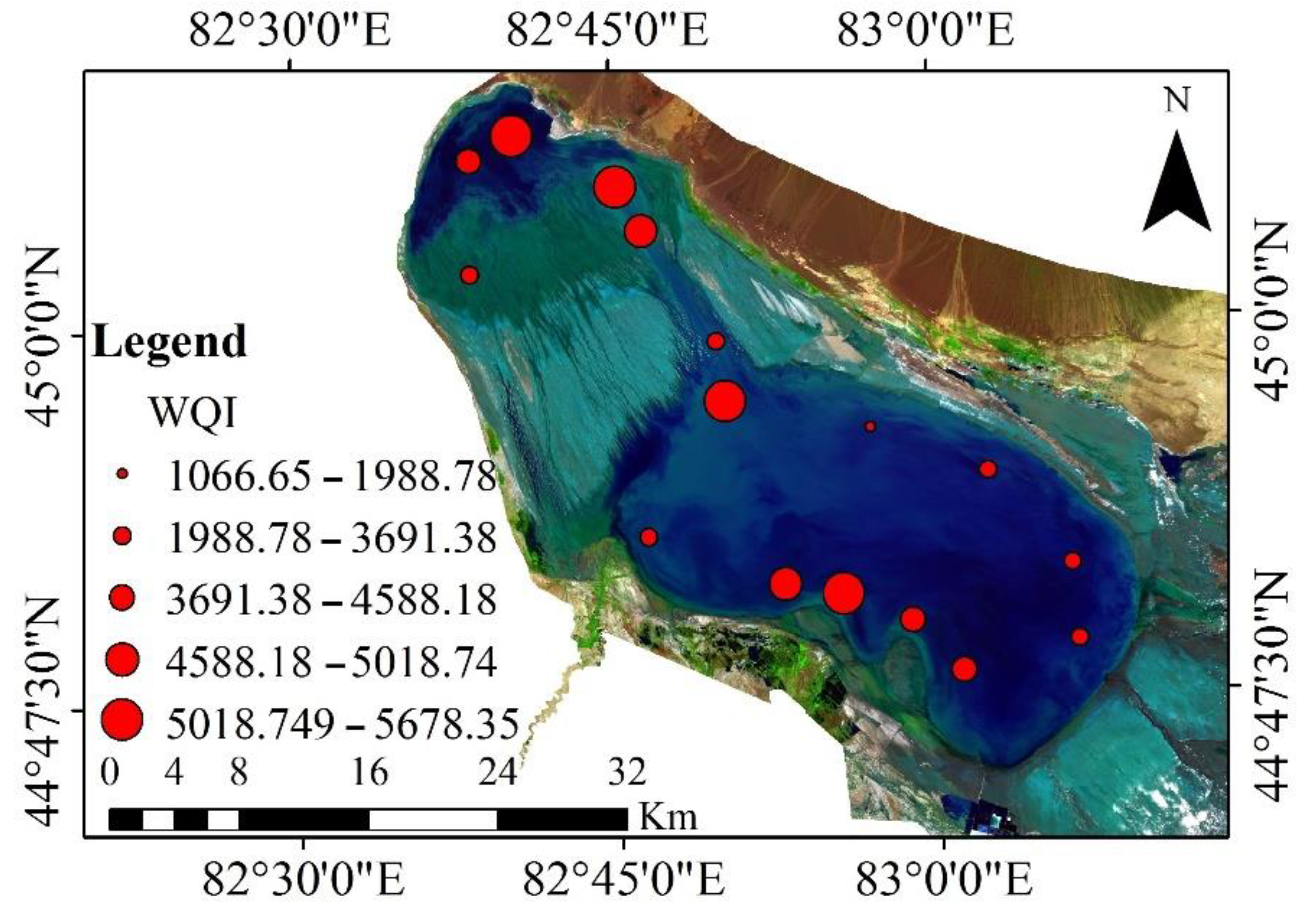
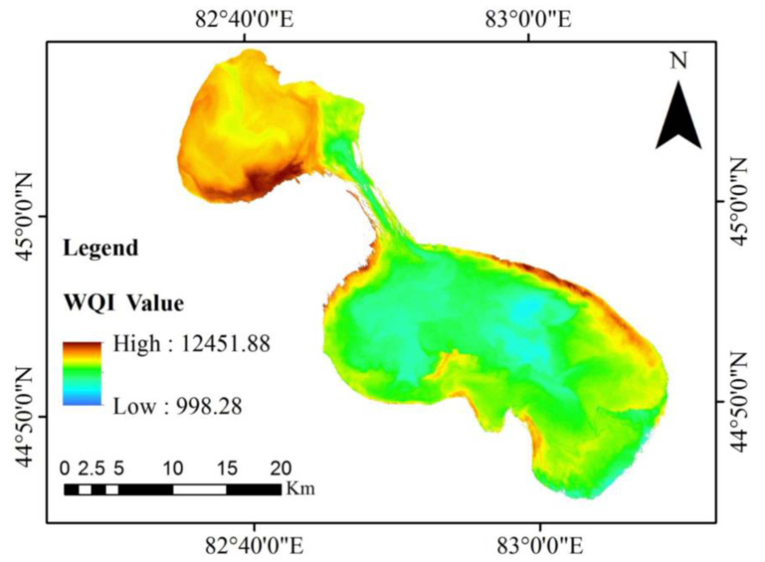
4.5. Spatial Distribution Map of WQI in Ebinur Lake
5. Discussion
5.1. Water Quality Index (WQI) as a Potential Proxy for Water Environment
5.2. Spectral Derivative Method and Spectral Indices as Useful Tools for Remote Sensing Modeling of Water Quality
6. Conclusions
- (1)
- A Water Quality Index (WQI), based on remote sensing techniques, effectively evaluated the water environment in Ebinur Lake. The Water quality of Ebinur Lake is the lowest, with a WQI value as high as 4000;
- (2)
- To better mine the information of spectral data from remote sensing, we introduced the spectral derivative method to realize the extraction of spectral information from a water body. The results show that the spectral derivative method can improve the relationship between the water body spectral and WQI, whereby the R2 value of 0.6 is at the most sensitive wavelengths;
- (3)
- When multi-source spectral data were integrated through the spectral index (DI, RI, and NDI) and fluorescence baseline, the correlation between the spectral sensitivity index and WQI was found to be greater than 0.6 at the significance level of 0.01;
- (4)
- The distribution map of WQI in Ebinur Lake was obtained by the optimal model, which was constructed based on the third derivative data of Sentinel 2 data. Results indicate that the water quality in the northwest of Ebinur Lake was the lowest in the region. In conclusion, remote sensing techniques were found to be highly effective and lay a foundation for water quality detection in arid areas.
Author Contributions
Funding
Data Availability Statement
Conflicts of Interest
References
- Cardinale, B.J. Biodiversity improves water quality through niche partitioning. Nature 2011, 472, 86–89. [Google Scholar] [CrossRef] [PubMed]
- Pekel, J.F.; Cottam, A.; Gorelick, N.; Belward, A.S. High-resolution mapping of global surface water and its long-term changes. Nature 2016, 540, 418–422. [Google Scholar] [CrossRef] [PubMed]
- Michalak, A.M. Study role of climate change in extreme threats to water quality. Nature 2016, 535, 349–350. [Google Scholar] [CrossRef] [PubMed]
- Feyisa, G.L.; Meilby, H.; Fensholt, R.; Proud, S.R. Automated Water Extraction Index: A new technique for surface water mapping using Landsat imagery. Remote Sens. Environ. 2014, 140, 23–35. [Google Scholar] [CrossRef]
- Kumar, V.; Sharma, A.; Chawla, A.; Bhardwaj, R.; Thukral, A.K. Water quality assessment of river Beas, India, using multivariate and remote sensing techniques. Environ. Monit. Assess. 2016, 188, 137. [Google Scholar] [CrossRef] [PubMed]
- Dörnhöfer, K.; Oppelt, N. Remote sensing for lake research and monitoring—Recent advances. Ecol. Indic. 2016, 64, 105–122. [Google Scholar] [CrossRef]
- Cheng, P.; Wang, X.L. The design and implementation of Remote-sensing Water Quality Monitoring System based on SPOT-5. In Proceedings of the Second IITA International Conference on Geoscience & Remote Sensing, Qingdao, China, 28–31 August 2010. [Google Scholar]
- Pulliainen, J.; Kallio, K.; Eloheimo, K.; Koponen, S.; Hallikainen, M. A semi-operative approach to lake water quality retrieval from remote sensing data. Sci. Total Environ. 2001, 268, 79–93. [Google Scholar] [CrossRef]
- Su, T.C. A study of a matching pixel by pixel (MPP) algorithm to establish an empirical model of water quality mapping, as based on unmanned aerial vehicle (UAV) images. Int. J. Appl. Earth Obs. Geoinf. 2017, 58, 213–224. [Google Scholar] [CrossRef]
- Burns, P.; Nolin, A. Using atmospherically-corrected Landsat imagery to measure glacier area change in the Cordillera Blanca, Peru from 1987 to 2010. Remote Sens. Environ. 2014, 140, 165–178. [Google Scholar] [CrossRef] [Green Version]
- Wang, X.P.; Zhang, F.; Ding, J.L. Evaluation of water quality based on a machine learning algorithm and water quality index for the Ebinur Lake Watershed, China. Sci. Rep. 2017, 7, 12858. [Google Scholar] [CrossRef] [Green Version]
- Alves, E.M.; Rodrigues, R.J.; Corrêa, C.S.; Fidemann, T.; Rocha, J.C.; Buzzo, J.L.L.; Note, P.O.; Núñez, G.F. Use of ultraviolet–visible spectrophotometry associated with artificial neural networks as an alternative for determining the water quality index. Environ. Monit. Assess. 2018, 190, 319. [Google Scholar] [CrossRef] [Green Version]
- Gogu, R.; Carabin, G.; Hallet, V.; Peters, V.; Dassargues, A. GIS-based hydrogeological databases and groundwater modelling. Hydrogeol. J. 2001, 9, 555–569. [Google Scholar] [CrossRef]
- Gholizadeh, M.H.; Melesse, A.M.; Reddi, L. A comprehensive review on water quality parameters estimation using remote sensing techniques. Sensors 2016, 16, 1298. [Google Scholar] [CrossRef] [PubMed] [Green Version]
- Kutser, T.; Paavel, B.; Verpoorter, C.; Ligi, M.; Soomets, T.; Toming, K.; Casal, G. Remote sensing of black lakes and using 810 nm reflectance peak for retrieving water quality parameters of optically complex waters. Remote Sens. 2016, 8, 497. [Google Scholar] [CrossRef]
- Giardino, C.; Bresciani, M.; Cazzaniga, I.; Schenk, K. Evaluation of multi-resolution satellite sensors for assessing water quality and bottom depth of lake garda. Sensors 2014, 14, 24116–24131. [Google Scholar] [CrossRef] [PubMed] [Green Version]
- Farhad, M.; Fatemeh, D.; Mostafa, R.; Baden, M. Introducing a water quality index for assessing water for irrigation purposes: A case study of the ghezel ozan river. Sci. Total Environ. 2017, 589, 107–116. [Google Scholar]
- Nuraslinda, A.; Pauzi, A.M.; Bakar, A.A.A. Methodology of water quality index (WQI) development for filtrated water using irradiated basic filter elements. Math. Sci. Its Appl. 2017, 1799, 040010. [Google Scholar]
- Horton, R.K. An index number system for rating water quality. J. Water Pollut. Control Fed. 1965, 37, 300–306. [Google Scholar]
- Brown, R.M.; McClelland, N.I.; Deininger, R.A.; Tozer, R.G. A water quality index-do we dare? Water Sew. Work. 1970, 117, 339–343. [Google Scholar]
- Debels, P.; Fıgueroa, R.; Urrutia, R.; Barra, R.; Niell, X. Evaluation of water quality in the Chilla’n river (Central Chile) using physicochemical parameters and a modified water quality index. Environ. Monit. Assess. 2005, 110, 301–322. [Google Scholar] [CrossRef]
- Saeedi, M.; Abessi, O.; Sharifi, F.; Maraji, H. Development of groundwater quality index. Environ. Monit. Assess. 2009, 163, 327–335. [Google Scholar] [CrossRef] [PubMed]
- Şener, Ş.; Şener, E.; Davraz, A. Evaluation of water quality using water quality index (WQI) method and gis in Aksu river (Sw-turkey). Sci. Total Environ. 2017, 584–585, 131–144. [Google Scholar] [CrossRef]
- D’Amico, F. Prompt-Particle-Events in ESA’s Envisat/MERIS and Sentinel-3/OLCI Data: Observations, Analysis and Recommendations. Master’s Thesis, University of Pisa, Pisa, Italy, 2015. [Google Scholar]
- Sibanda, M.; Mutanga, O.; Rouget, M. Examining the potential of Sentinel-2 MSI spectral resolution in quantifying above ground biomass across different fertilizer treatments. ISPRS J. Photogramm. Remote Sens. 2015, 110, 55–65. [Google Scholar] [CrossRef]
- Liu, C.J.; Duan, P.; Zhang, F.; Jim, C.Y.; Tan, M.L.; Chan, N.W. Feasibility of the Spatiotemporal Fusion Model in Monitoring Ebinur Lake’s Suspended Particulate Matter under the Missing-Data Scenario. Remote Sens. 2021, 13, 3952. [Google Scholar] [CrossRef]
- Hoge, F.E.; Lyon, P.E.; Swift, R.N.; Yungel, J.K.; Abbott, M.R.; Letelier, R.M.; Esaias, W.E. Validation of Terra-MODIS phytoplankton chlorophyll fluorescence line height. I. Initial airborne lidar results. Appl. Opt. 2003, 42, 2767. [Google Scholar] [CrossRef] [PubMed]
- Brown, R.M.; McClelland, N.I.; Deininger, R.A.; O’Connor, M.F. A Water Quality Index -Crashing the Psychological Barrier. In Indicators of Environmental Quality; Thomas, W.A., Ed.; Springer: Boston, MA, USA, 1972. [Google Scholar] [CrossRef]
- Dede, O.T.; Telci, I.T.; Aral, M.M. The Use of Water Quality Index Models for the Evaluation of Surface Water Quality: A case study for Kirmir Basin, Ankara, Turkey. Water Qual. Expo. Health 2013, 5, 41–56. [Google Scholar]
- Harkins, R.D. An Objective Water Quality Index. J. (Water Pollut. Control. Fed.) 1974, 46, 58591. [Google Scholar]
- Wu, Z.S.; Wang, X.L.; Chen, Y.W.; Cai, Y.J.; Deng, J. Assessing river water quality using water quality index in Lake Taihu Basin, China. Sci. Total Environ. 2018, 612, 914–922. [Google Scholar] [CrossRef]
- Mukate, S.; Wagh, V.; Panaskar, D.; Jacobs, J.A.; Sawant, A. Development of new integrated water quality index (IWQI) model to evaluate the drinking suitability of water. Ecol. Indic. 2019, 101, 348–354. [Google Scholar] [CrossRef]
- Wiley, E.O.; Mcnyset, K.M.; Peterson, A.T.; Robins, C.R.; Stewart, A.M. Niche modeling and geographic range predictions in the marine environment using a machine-learning algorithm. Oceanography 2003, 16, 120–127. [Google Scholar] [CrossRef] [Green Version]
- Marjanović, M.; Kovačević, M.; Bajat, B.; Voženílek, V. Landslide susceptibility assessment using SVM machine learning algorithm. Eng. Geol. 2011, 123, 225–234. [Google Scholar] [CrossRef]
- Peón, J.; Fernández, S.; Recondo, C.; Calleja, J.F. Evaluation of the spectral characteristics of five hyperspectral and multispectral sensors for soil organic carbon estimation in burned areas. Int. J. Wildland Fire 2017, 26, 230–239. [Google Scholar] [CrossRef]
- Fernández-Buces, N.; Siebe, C.; Cram, S.; Palacio, J.L. Mapping soil salinity using a combined spectral response index for bare soil and vegetation: A case study in the former Lake Texcoco, Mexico. J. Arid Environ. 2006, 65, 644–667. [Google Scholar] [CrossRef]


| Class | Threshold Value | Water Quality |
|---|---|---|
| I | ≥50 | Excellent water |
| II | (50–100) | Good water |
| III | [100–200) | Poor water |
| IV | [200–300) | Very poor water |
| V | ≥300 | Unsuitable for drinking |
| Derivative Order | RI | DI | NDI | |||
|---|---|---|---|---|---|---|
| Band | R | Band | R | Band | R | |
| 0 | Oa13/Oa17 | 0.701 | Oa4 − Oa5 | 0.705 | (Oa4 − Oa5)/(Oa4 + Oa5) | 0.701 |
| 1 | Oa5/Oa20 | 0.695 | Oa3 − Oa8 | 0.662 | (Oa3 − Oa8)/(Oa3 + Oa8) | 0.622 |
| 2 | Oa1/Oa3 | 0.602 | Oa5 − Oa21 | 0.602 | (Oa5 − Oa21)/(Oa5 + Oa21) | 0.592 |
| Derivative Order | RI | DI | NDI | |||
|---|---|---|---|---|---|---|
| Band | R | Band | R | Band | R | |
| 0 | B2/B4 | 0.706 | B5 − B6 | 0.741 | (B2 − B4)/(B2 + B4) | 0.704 |
| 1 | B3/B5 | 0.763 | B3 − B6 | 0.763 | (B3 − B5)/(B3 + B5) | 0.776 |
| 2 | B3/B4 | 0.741 | B4 − B11 | 0.778 | (B3 − B4)/(B3 − B4) | 0.731 |
| 3 | B5 − B8 | 0.736 | B5 − B7 | 0.741 | (B4 − B5)/(B4 − B5) | 0.735 |
| Order | X | Y | PSO-SVR | |||||
|---|---|---|---|---|---|---|---|---|
| R2 | RMSE | SD | RPD | Slope | N | |||
| 0 | WQIM | WQIP | 0.69 | 344.67 | 503.07 | 1.45 | 0.73 | 16 |
| 1 | WQIM | WQIP | 0.73 | 302.18 | 492.36 | 1.62 | 0.77 | 16 |
| 2 | WQIM | WQIP | 0.79 | 245.69 | 398.06 | 1.62 | 0.81 | 16 |
| 3 | WQIM | WQIP | 0.81 | 213.41 | 398.72 | 1.86 | 0.84 | 16 |
| Order | X | Y | PSO-SVR | |||||
|---|---|---|---|---|---|---|---|---|
| R2 | RMSE | SD | RPD | Slope | N | |||
| 0 | WQIM | WQIP | 0.76 | 233.14 | 412.38 | 1.76 | 0.76 | 16 |
| 1 | WQIM | WQIP | 0.73 | 342.72 | 521.09 | 1.52 | 0.72 | 16 |
| 2 | WQIM | WQIP | 0.69 | 354.47 | 519.84 | 1.46 | 0.71 | 16 |
| FLH | WQIM | WQIP | 0.80 | 200.78 | 359.28 | 1.79 | 0.84 | 16 |
Publisher’s Note: MDPI stays neutral with regard to jurisdictional claims in published maps and institutional affiliations. |
© 2021 by the authors. Licensee MDPI, Basel, Switzerland. This article is an open access article distributed under the terms and conditions of the Creative Commons Attribution (CC BY) license (https://creativecommons.org/licenses/by/4.0/).
Share and Cite
Zhang, F.; Chan, N.W.; Liu, C.; Wang, X.; Shi, J.; Kung, H.-T.; Li, X.; Guo, T.; Wang, W.; Cao, N. Water Quality Index (WQI) as a Potential Proxy for Remote Sensing Evaluation of Water Quality in Arid Areas. Water 2021, 13, 3250. https://doi.org/10.3390/w13223250
Zhang F, Chan NW, Liu C, Wang X, Shi J, Kung H-T, Li X, Guo T, Wang W, Cao N. Water Quality Index (WQI) as a Potential Proxy for Remote Sensing Evaluation of Water Quality in Arid Areas. Water. 2021; 13(22):3250. https://doi.org/10.3390/w13223250
Chicago/Turabian StyleZhang, Fei, Ngai Weng Chan, Changjiang Liu, Xiaoping Wang, Jingchao Shi, Hsiang-Te Kung, Xinguo Li, Tao Guo, Weiwei Wang, and Naixin Cao. 2021. "Water Quality Index (WQI) as a Potential Proxy for Remote Sensing Evaluation of Water Quality in Arid Areas" Water 13, no. 22: 3250. https://doi.org/10.3390/w13223250
APA StyleZhang, F., Chan, N. W., Liu, C., Wang, X., Shi, J., Kung, H.-T., Li, X., Guo, T., Wang, W., & Cao, N. (2021). Water Quality Index (WQI) as a Potential Proxy for Remote Sensing Evaluation of Water Quality in Arid Areas. Water, 13(22), 3250. https://doi.org/10.3390/w13223250