1. Introduction
The hydrological cycle is the process upon which all organisms on earth depend for their survival. It is the engine of environmental and ecological conditions on earth [
1]. Over the past few decades, several studies have revealed that river flow is linked to many environmental relationships, especially in arid and semiarid areas [
2]. Its variations are mainly due to two aspects, namely global climate change and direct human interventions. This contributes to the resulting consequences, a more pronounced scarcity of water resources and more serious environmental deterioration [
3,
4,
5,
6].
The accelerated global change leaves little time to adjust. Although the need for adaptation to climate change is recognized, there is also a need for adaptation to change affecting land use [
7]. Thus, it is essential to understand the causal chains of the processes of river flow variation. As a result, the scientific community has started to analyze the factors behind changes and the possible consequences of these changes [
8]. Several factors influence the catchment runoff, including precipitation, temperature, potential evapotranspiration, topography, soil texture, and land use [
9]. Human activities are recognized as a major factor affecting river runoff [
10]. This appears in deforestation, land use change, soil and water conservation practices, and exploitation of surface and groundwater reservoirs and water supply [
11,
12]. Human activities have many negative effects on the environment [
13]. This leads, directly or indirectly, to a modification of the quantitative and qualitative characteristics of the river flow. Indeed, changes affecting the land often lead to a significant downward trend in river flow [
14]. In addition, the effect of climate change, which modifies precipitation and promotes evapotranspiration by increasing temperature, increases the risk of disturbing the flow of wadis [
15]. Thus, the hydrological response to climate change and human activities differs from one area to another [
16].
Impact studies of climate change by hydrological models show varying results. Their applications remain limited in watersheds with inadequate data [
1]. Thus, conceptual models are replaced by methods based on statistical approaches [
17]. The statistical methods are mainly based on trend analysis and the equations of Budyko [
18]. During recent years, some research has focused on trend by addressing the influence of length of empirical time series [
19,
20]. The Budyko approach is based on the concept of climate elasticity [
18]. This approach can be used to quantify the sensitivity of river flow to climatic variation. These results will subsequently be useful in designing appropriate management strategies [
6]. Additionally, understanding of how flow is affected by land use and climate change is essential to inform adaptive soil and water management.
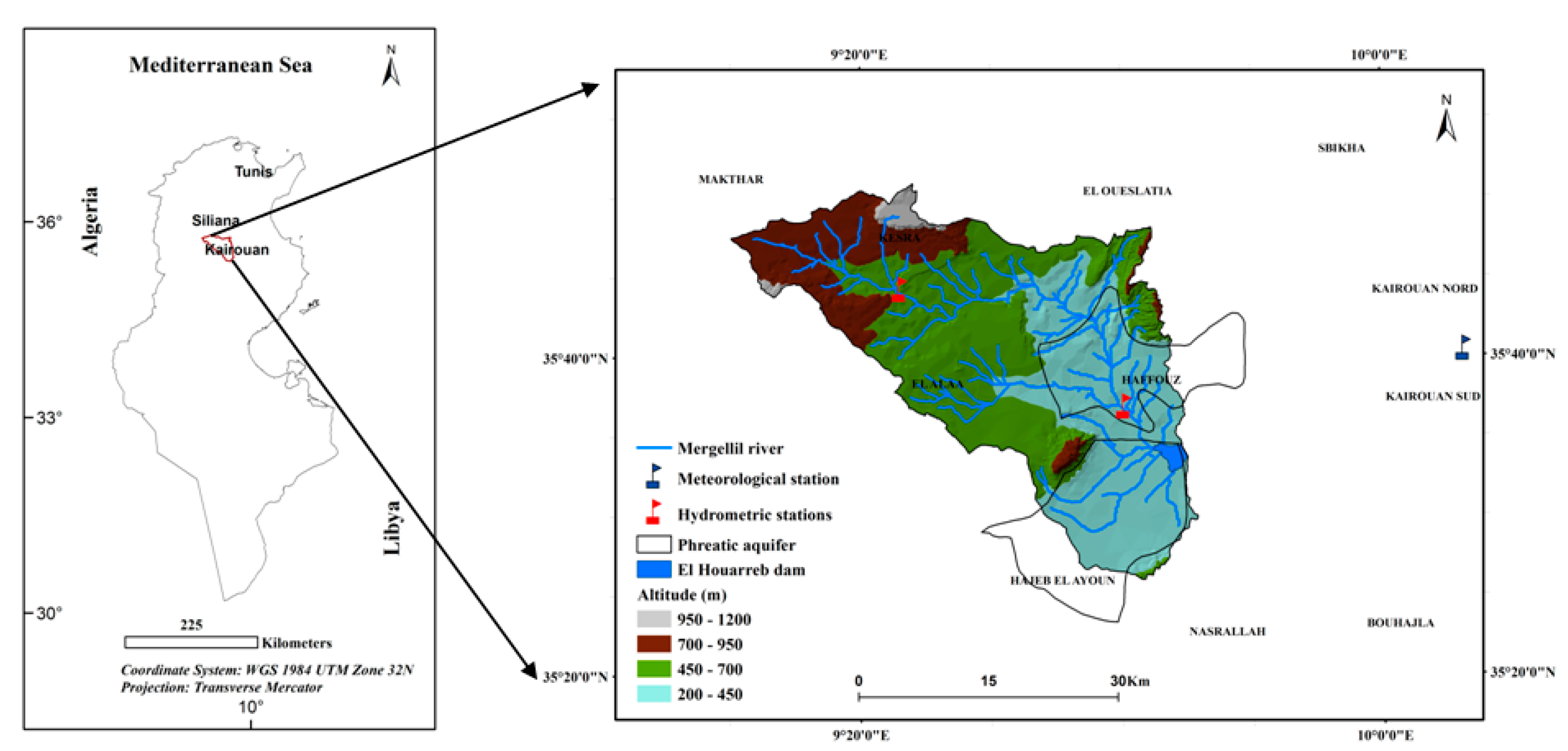
The Tunisian semiarid context provides an illustrative example of hydrological processes deeply modified by anthropogenic influence [
21]. The Merguellil Wadi, the main river in the Merguellil watershed located in central Tunisia, has undergone extremely marked “socio-hydrological” evolution. Its current state is the legacy of a long history of interactions between man and environment [
22]. In addition, the watershed is highly vulnerable to climate change that may change river flow [
23]. Further, overexploitation of groundwater, agricultural irrigation, and overgrazing can further disrupt the hydrological balance.
In view of the above, the objectives of the present study were partly to improve the understanding on the effects of climate change and direct anthropogenic changes, and partly to assess the impact of length of observed time series by the ITA method (Innovative Trend Analysis) proposed by Şen [
24,
25]. The ITA method is used in this study since its comparison with conventional methods shows certain advantages [
26]. It has been used in the detection of trends for several hydrometeorological variables such as evaporation, river, flow, and precipitation in different regions [
26,
27,
28,
29]. This method can indicate potential future impacts of climate change, management, and design of hydraulic structures [
24].
Assessment of the impact of climate change and direct human activities on streamflow is performed using the approach of Budyko [
18] and an NDVI index calculated by multispectral Landsat satellite imagery. The analyses use data from a 40-year period from the Merguellil watershed. The length of time series allows us to compare the hydrological context between shorter study periods in the Tunisian semiarid area. This is one of the first studies that performs a quantitative assessment of the impact of climate change and direct human activity on streamflow variation in the Merguellil Wadi.
4. Discussion
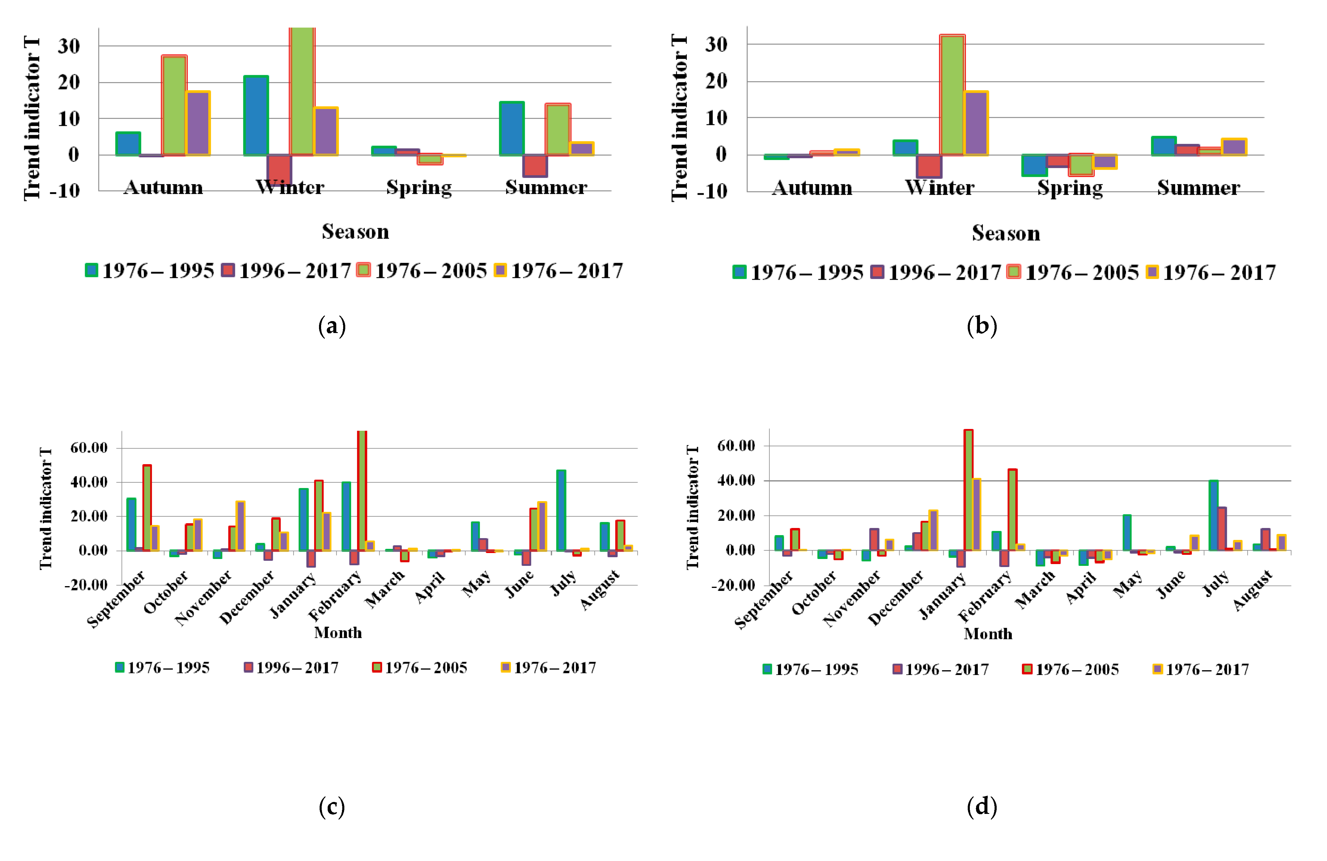
Analysis of flow trend by the ITA method in the Merguellil watershed over the periods of 20, 30, and 40 years shows that the impact of time series length on the magnitude of trends is substantial. In fact, on a monthly scale a positive trend for P1 and negative for P2 for the 20-year period is not found in the 30 and 40-year periods, respectively. Indeed, at longer observation periods (≥30 year), the trend is increasing for annual flow. However, it is decreasing for extreme values of flow rates. In addition, one can notice a concordance of the magnitude of the trends during the four periods. This concordance appears, increasing in the watershed, particularly in spring during March and April. Downstream in the watershed, the concordance of magnitudes of trends characterized autumn, summer, and September, October, March, April, and June. The ITA method has certain advantages for flow series analyses. The approach allows for more detailed interpretation of trend detection, which is useful for identifying hidden trends over time. The ITA method identified statistically significant upward and downward trends over the 30-year period. In this framework, we observed a high degree of connection of magnitudes of the trends for the 20 and 40-year series.
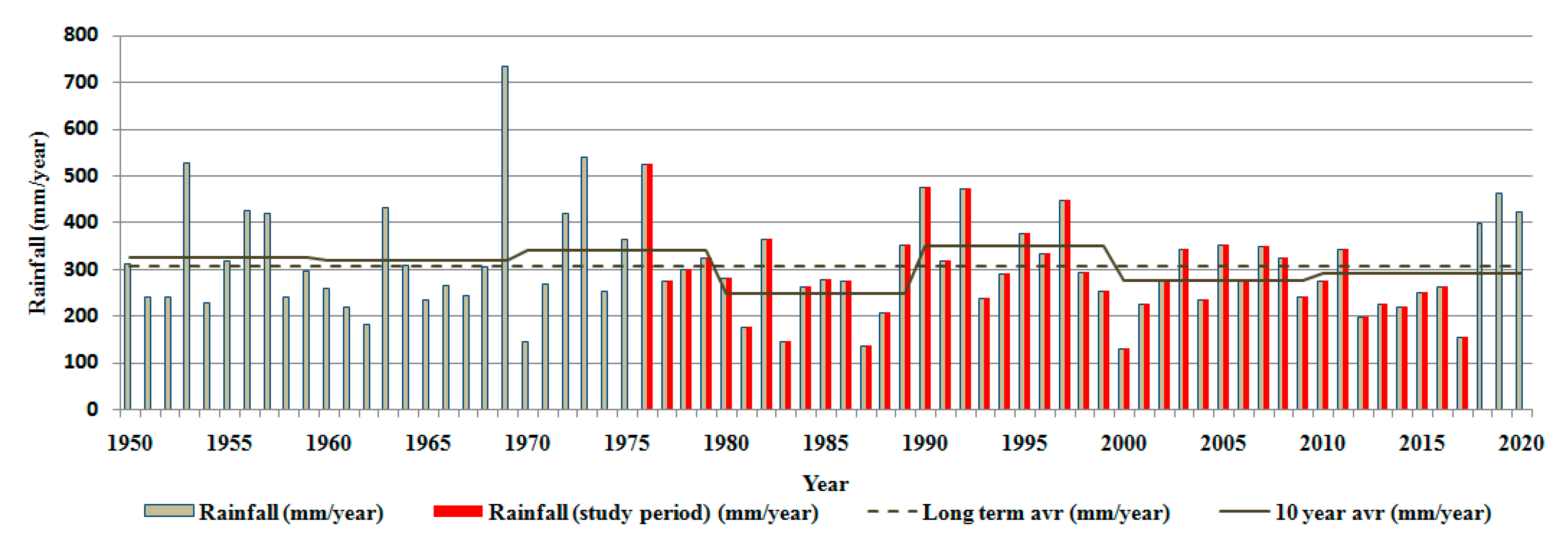
The 20-year trend magnitude results show a negative sign that is statistically significant. This is mainly due to the deficit years experienced in the study area (
Figure 2). Consequently, these results reflect the hydrological variability of the Merguellil watershed and not the hydrological trend linked to climate change. The 30-year series analysis identified a clear trend. Similarly, the 40-year series showed rather moderate amplitudes (
Figure 6). In conclusion, the 30 and 40-year series showed pronounced and moderate impact of climate change, respectively.
Statistical results of the study show that the hydrological response of stream flow is much greater upstream than downstream. The last three decades illustrate a 40% reduction in inflow to the dam. This is in accordance with what has been published in the yearly hydrological reports by the Kairouan hydrological department. Indeed, the Merguellil Wadi recorded zero flow for the first time in 1979 at Haffouz. Thus, a clear downward trend is observed between 1976–1977 and 1988–1989. This follows a succession of years of deficit due to the reduction in rainfall events of more than 30 mm [
62]. In addition, despite the surplus period over five consecutive years from 2002–2003 to 2006–2007, an absence of decrease in rainfall over the watershed and across Tunisia was recorded [
13,
63,
64,
65,
66]. Thus, the Merguellil Wadi remains in a vulnerable situation.
Climate elasticity of annual flow expresses the percentage change in flow as a function of percentage change in climatic variables. It is proportional to precipitation, temperature, and increases with temperature if precipitation decreases and decreases with temperature if precipitation increases [
67]. The results of the present study show that the climate elasticity of flow is variable. This lack of stationarity contradicts the conclusion of Sankarasubramanian et al. [
55]. In addition, it can take negative signs (
Table 5). This means that the reduction in input is combined with an increase in temperature, which tends to increase evapotranspiration, followed by a decrease in precipitation [
68,
69]. Therefore, the availability of water in the study area will likely be more critical in the future with current projections of global warming. An increase of 2 °C is likely to be followed by a significant decrease in water availability by 2 to 15% [
70].
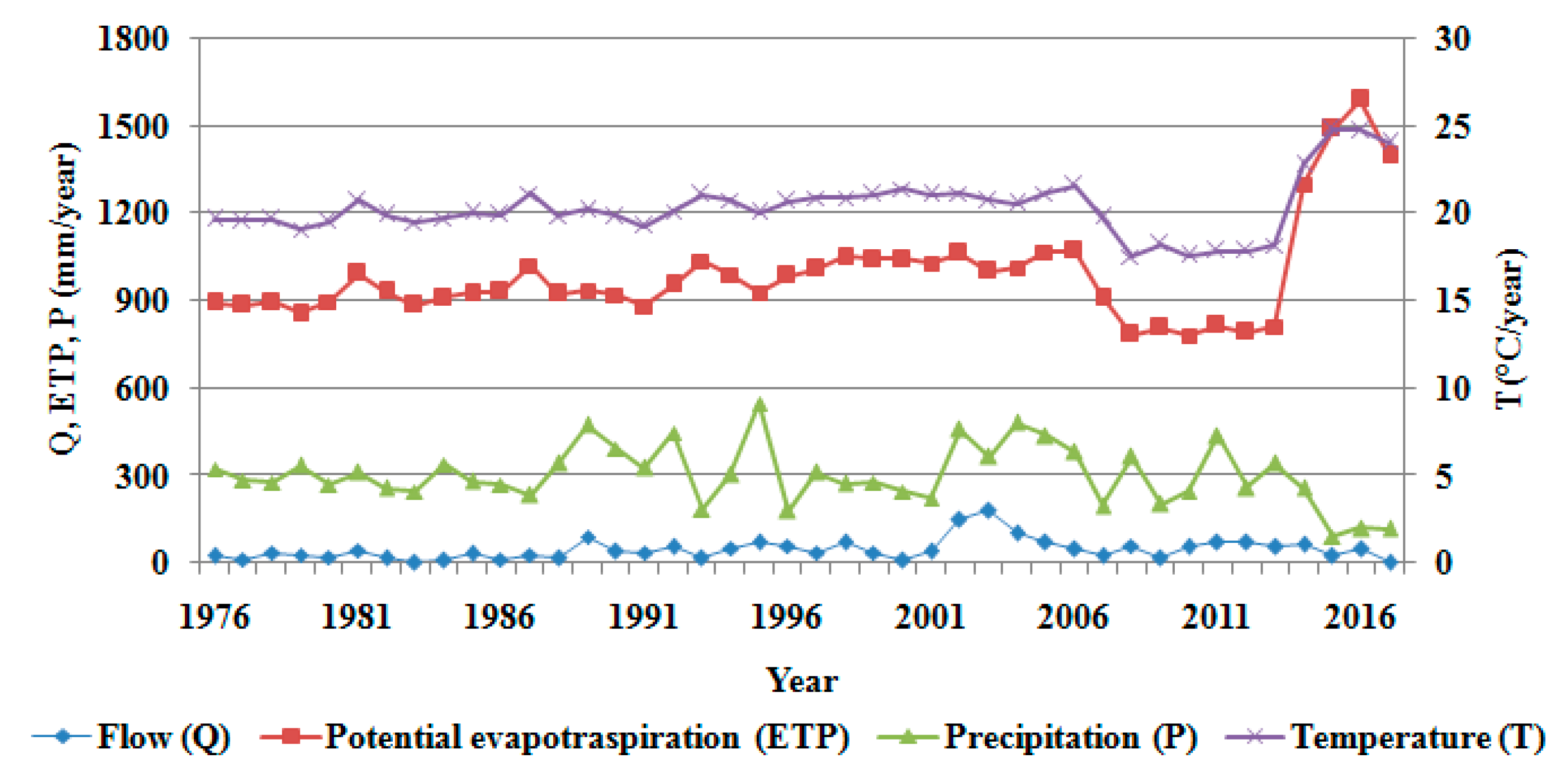
Our results suggest that the effect of climatic factors on the average annual flow increases from upstream to downstream of the watershed. This agrees with the results of Tsai [
71]. Indeed, it is quite natural that our estimates of the effects of precipitation and evapotranspiration on the average flow in the Haffouz station differ from those estimated in the north of the watershed, at the Skhira station. A forest cover and an altitude, which varies from 700 to 1200 m, characterize the north. In addition, the effect of temperature on low water flow in the Haffouz region, an area characterized by a permeable soil texture, is greater than that on the average flow in the Skhira station.
The elasticity of potential evapotranspiration throughout the study period for the upstream is higher than downstream of the watershed. This indicates that the response of the Merguellil Wadi is more sensitive to potential evapotranspiration than precipitation. Certainly, evapotranspiration through vegetation significantly affects the flow, especially at the end of the growing season [
72]. In general, the effects of non-climatic factors include changes in land use and human activities have been shown to be influencing factors for water supply. Vegetation changes in the Merguellil watershed (
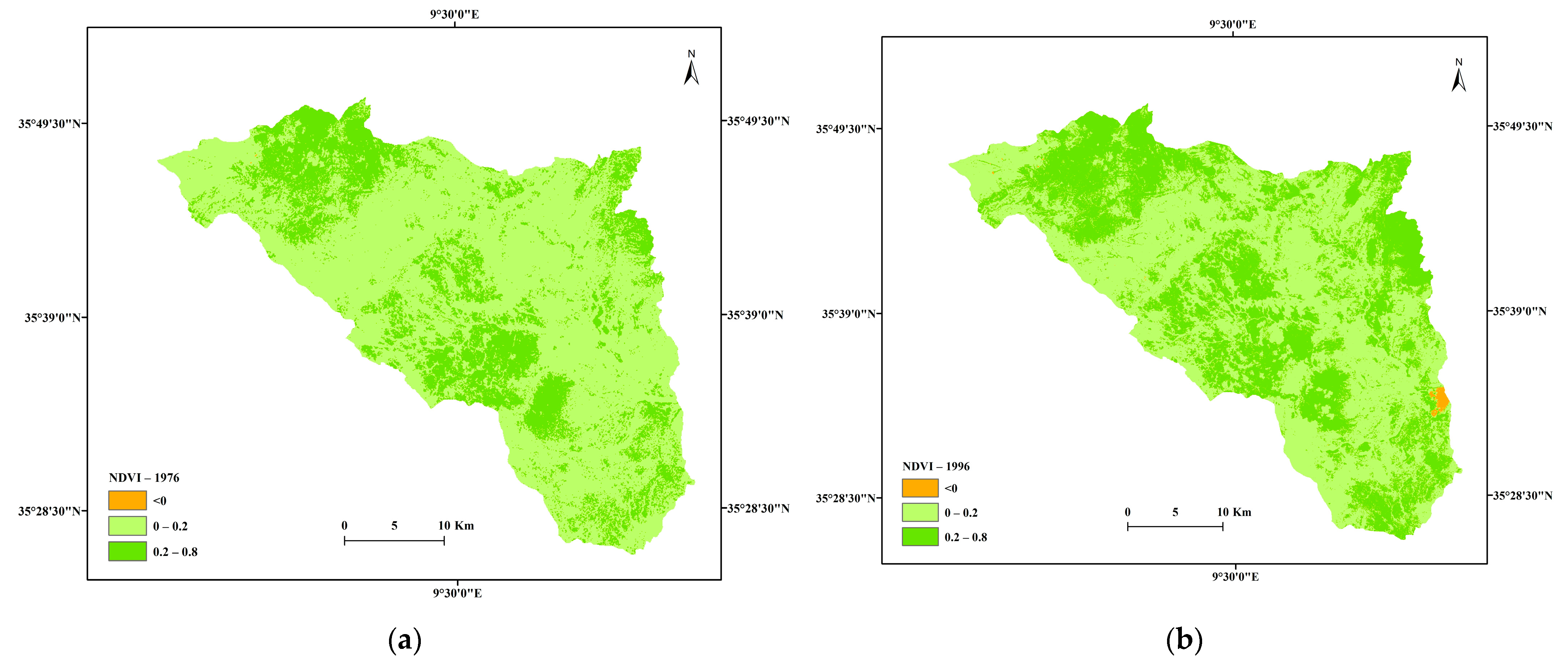
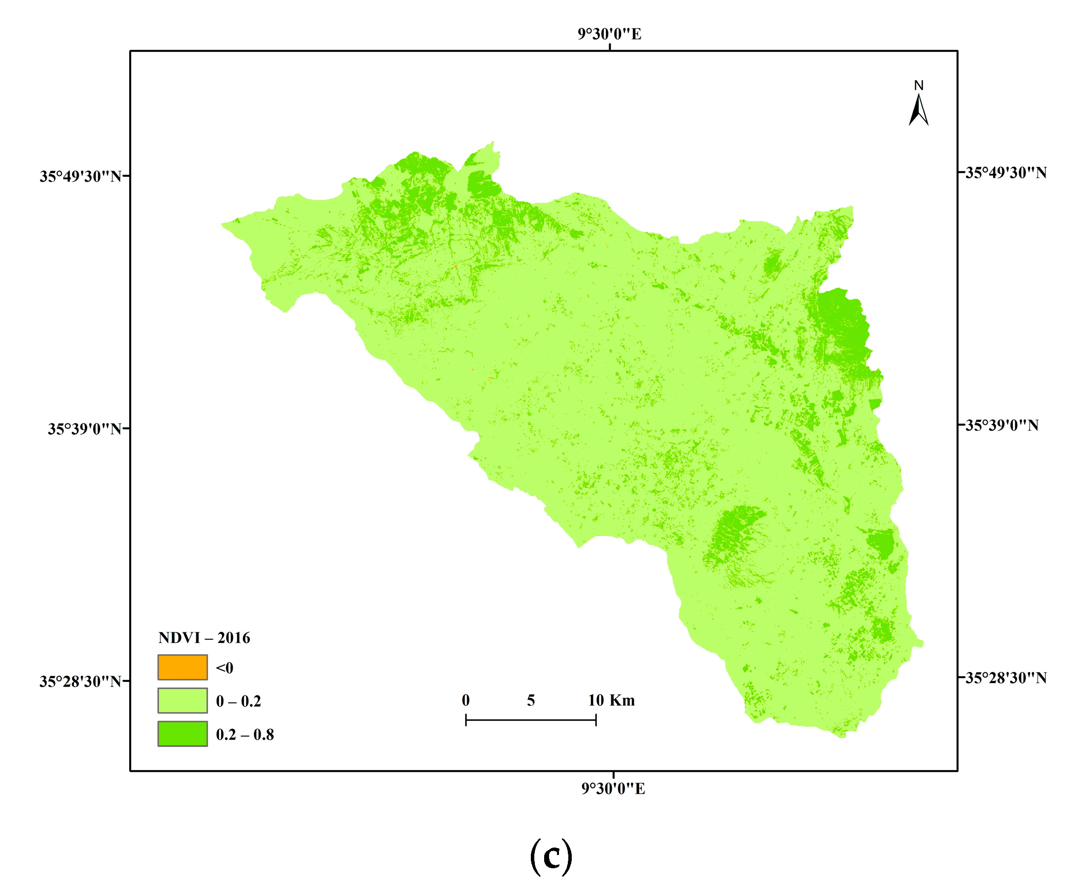
Figure 7) come about because of government intervention in the Kairouan region. This intervention aims to improve the country’s self-sufficiency in certain products (vegetables, fruits, and cereals) and the supply of agricultural products to feed the livestock [
73]. Thus, an extension of the cultivated area following governmental investments in water saving equipment linked to the development of drip irrigation between 1999 and 2005 [
74].
Although, the results of the combination of the effects of climate change and land use show a reduction in water supplies to the basin. Human contribution plays an important role for the Merguellil watershed [
22]. The growing demand of water for agricultural, domestic, and industrial purposes has led to overuse of surface and groundwater. The withdrawal of surface water will reduce the flow directly. Thus, the overexploitation of groundwater leaves a void to be filled by surface runoff, thus reducing the flow of watercourses.
Soil texture plays a role in the evolution of runoff. Indeed, upstream of the watershed (Skhira station), the riverbed of the Merguellil Wadi is formed by hard rocks with a stable section. Downstream, at the Haffouz station, the Merguellil bed is wide, formed by unstable sandy formations. It is then exposed to erosion phenomena, which means that the section changes shape almost at each passage of a flood [
34]. Water for domestic, irrigation, industrial, and tourist use is being taken from deep groundwater of the Merguellil watershed. In addition, the disturbance of the hydrological balance in the study area can be explained by feedback from local residents following the disappearance of the low flow of Wadi Merguellil and its drying up since 1981 [
34,
75]. This consequence appeared following a political strategy to draw down the groundwater system of Bouhefna, located in the center of the study area (
Figure 1), since the mid-1970s. This strategy aims to reduce water losses by evapotranspiration and for hydrogeological purposes. It therefore induces excessive hydrodynamic exploitation of underground resources [
34]. This is planned in the expansion of agricultural pumping along the Wadi, by abandoning traditional irrigation canals, installing motor pumps, and setting up deep boreholes in the alluvium of the Wadi or wells on the banks from the 1980s. The transfer of water from Bouhefna to the coastal regions presents another explanatory factor for the hydrological changes experienced in the Merguellil watershed that is widely contested by the local population [
21].
In a semiarid region such as the Merguellil watershed, the hydrological processes are characterized by an extreme spatiotemporal variability (e.g., [
76]). The high rainfall variability requires human intervention to mitigate the landscape change. We particularly mention soil and water conservation practices and careful land use/land cover management. Indeed, surface runoff is generated by exceptional events that are rare but complex [
77,
78]. However, only extreme events produce significant runoff.
The expansion of water and soil conservation management has led to a marked decrease in runoff in the Merguellil watershed [
41]. Many investigations have focused on the variability of runoff coefficient (e.g., [
79,
80,
81]). In this regard, by analyzing 114 comparable events over the period 1989–2010, Ogilvie et al. [
82] estimated a 40% reduction in the runoff coefficient following the expansion of water and soil conservation practices since 1996 with a decrease of 25% in annual flow at the basin outlet. Lacombe et al. [
83] estimated that the sharp drop in flow arriving at the El Haouareb Dam over the past 40 years is due to a reduction of runoff generated by events below 40 mm from 28 to 32% and a reduction of 41–50% for all events over the period 1989–2005.
In conclusion, this research shows the importance of the flow to identify the impact of climatic change and anthropogenic activities in a Tunisian semiarid context. Thus, it is recommended that the length of the hydrological series should not be less than 30 years when analyzing the impact of climate change on streamflow. This can therefore serve as a benchmark for future research. In addition, this study confirms the importance of using seasonal and monthly flow data in trend analysis, rather than simple annual averages which may sometimes not reveal the full spatiotemporal complexity of flow trends.
Ultimately, this study identifies the importance of the continuity of research, which has been initiated in the Merguellil watershed for more than 50 years. This continuity has made it possible to show that anthropogenic effects make water scarcity a permanent situation in a semiarid context. The purpose of this is to guide rural development agents to consider water management and saving models adapted to climate change and land use to avoid finding themselves in similar situations in the future.
5. Conclusions
This study assessed impacts of climate change and direct human activities on streamflow in the Merguellil watershed. Trend at monthly, seasonal, and annual time scales was studied using the ITA method over the period 1976–2017 divided into periods of about twenty years each (P1: 1976–1995; P2: 1996–2017), about thirty years (P3: 1976–2005), and about forty years (P4: 1976–2017). The purpose was, on the one hand, to provide a length of series capable of informing us about the impact of climate change and on the other hand, allowing us to compare the hydrological contexts between the different study periods. Analysis of the trend shows that the hydrological response of flows is much greater upstream than downstream. The average annual flow towards the outlet of the watershed, the El Houarreb Dam, has decreased significantly over the past thirty years by about 40%. Extreme low flows have increased in high and medium altitudes, thus constituting a constant pressure on the availability of water resources in the watershed where the residents depend on agricultural activities. Strong points of this study are the precision of the detection of long-term trends. A 20-year time series reflects the hydrological variability and the characteristics of the watershed. This observation time, however, does not reflect the hydrological trends linked to climate change. Indeed, only series of 30 years and more can clearly and explicitly identify the impact of climate change. From the 40-year data, we can identify climatic impact that is more objective for an optimal management of water resources. In addition, this study confirms the importance of using seasonal and monthly flow data in trend analysis. Indeed, simple annual averages cannot reveal the spatiotemporal complexity of flow trends. The calculation of the NDVI index by using the three Landsat images provided an overview for a global qualitative analysis of the contribution of human activities on streamflow variation in the watershed during the study period. The spatial distribution of land cover for the three dates considered, namely 1976, 1996, and 2016, indicates an increase in cultivated land of 14% during the 40 years of the study. The elasticities of precipitation and potential evapotranspiration throughout the study period, for the upstream of the watershed are 1.26 and −0.26, respectively. While in the downstream of the watershed, they are 1.35 and −0.35, respectively. This fact indicates that the response of the Merguellil Wadi is more sensitive to precipitation than to potential evapotranspiration. The direct impact of human activities on water supplies in the Merguellil watershed is responsible for more than about 55% of overall river flow change. Climate change contributes less than about 22%. Therefore, the study area is subject to intensive human impact due to social and economic development for more than 50 years. Direct human activities are the main factor in the reduction of river flow. Even more, these results show the impact of historical context in terms of anthropogenic effects.
Ultimately, the flow remains a variable and a key indicator for decision-makers to consider for its spatiotemporal variability. Therefore, it is recommended that the hydrological observation times should not be less than 30 years when analyzing flows. This allows restoring the impact of climate change and those of human activities in Tunisia. This information is essential for the sustainable management of water resources. In addition, it can give implications for analytical decisions on interpretations of the hydrological response and on planning and development both upstream and downstream of the watershed.


