Abstract
Check dams play an irreplaceable role in soil and water conservation in the Chinese Loess Plateau region. However, there are few analyses on the connection between check dams and the downstream channel and the impact on structural connectivity and sediment interception efficiency. Based on a field survey, this study classified the connection mode between check dams and the downstream channel, and the actual control area percentage by discharge canal in dam land was used to quantitatively evaluate the degree of the structural connectivity of sediment between the check dam and the downstream channel. The analysis results show that the connection mode can be divided into eleven categories with different structural connectivity. The different connection modes and its combination mode of check dams and downstream channels in dam systems have a large difference, and the structural connectivity of the dam system is less than or equal to that of the sum of single check dams in a watershed. The degree of structural connectivity of a dam system will be greatly reduced if there is a main control check dam with no discharge canal in the lower reaches of the watershed. Compared with a single check dam, the structural connectivity of a dam system is reduced by 0–42.38%, with an average of 11.18%. According to the difference in connection mode and structural connectivity of check dams and dam systems in the four typical small watersheds, the optimization methods for connection mode in series, parallel and hybrid dam systems were proposed. The research results can provide a reference for the impact of a check dam on the sediment connectivity and the sediment interception efficiency in a watershed and can also guide the layout of a dam system and the arrangement of drainage facilities.
1. Introduction
The Loess Plateau is the area most seriously affected by soil and water loss in the world, and its soil and water loss control has been the focus of attention and research by scholars. Since the 1950s, with the gradual implementation of a series of restoration measures, such as returning farmland to forests (grass) and the construction of check dams, the amount of sediment discharged into the Yellow River has decreased significantly. The average annual sediment discharge at the Tongguan hydrological station has decreased from 1.6 billion tons before the 1970s to 179 million tons in 2010–2020 [1], which shows that the water and soil control and management of the Loess Plateau have achieved remarkable results. However, the reduction of the sediment put into the Yellow River does not fully explain that the soil erosion of the Loess Plateau has been effectively controlled because the whole watershed has been treated as a “black box” when the sediment discharge was monitored at the outlet, and it is difficult to explain the degree and process of soil erosion on multiple scales in the watershed [2,3]. The low sediment load does not only not indicate that the watershed is in a healthy state [4], it may also ignore the hot spots of erosion in the watershed and the potential harm caused by sedimentation [5].
Among the many soil and water conservation measures in the Chinese Loess Plateau region, check dams are one of the most effective ways to intercept sediment and control erosion in both the short-term and the long-term [6]. There were 56,422 check dams in the area controlled by Tongguan hydrological station on the Loess Plateau, of which 41,008 check dams had been filled up [7,8], and there are still many uncounted small check dams [9]. As soon as a check dam is built, it begins to play a role in flood control and sediment retention in the dam-controlled watershed. Sediment deposition in check dams leads to a decrease in bed slope, which makes significant alterations in the cross-sectional geometry and characteristics of bed sediments [10,11,12]. However, the influence of check dams on longitudinal and transverse sediment connectivity has not been analyzed in depth. Some scholars considered that check dams disrupted the longitudinal sediment connectivity in a catchment [13,14,15], while some others say the opposite [12].
Usually, most of the previous studies have focused on the sediment interception efficiency of check dams under the ideal conditions that the check dam could completely intercept the upstream sediment [9], but less attention has been paid to the connection mode of check dams and its effect on the sediment connectivity [12,16], and the analysis about the connection mode and degree between check dam and downstream channel based on the different drainage buildings and spillways (DBS) [16]. In fact, as the barrier node of sediment transport in the channel, the connection modes and degrees of check dam to the downstream channel are different due to the different types of drainage measures, the sediment interception efficiency is also quite different. Due to the influence of extreme rainfall and human activities, many check dams have been damaged to varying degrees [17]; the gaps formed in damaged dam bodies act as spillways when check dams were damaged under extreme rainfall [18,19]. Whether it is the discharge channel, drainage building and spillway to meet the design standards, the discharge channel excavated in the course of agricultural production or the dam body damaged by natural or human activities, all of these will lead to the connection between dam land and the downstream channel. The discharge canal was built at the foot of the slope on one side of dam land and caused the originally disconnected check dam to be connected to the downstream channel. Therefore, many check dams have not completely intercepted the sediment from the dam land from the dam-controlled watershed; part of the sediment is transported to the downstream channel by the drainage building, discharge canal, spillway or dam body damaged gap. The connection mode between the check dam and the downstream channel is much more complicated, especially in a dam system; this has led to a huge difference in the degree of sediment connectivity. It is necessary to find new methods to evaluate the sediment interception efficiency of check dams based on the new understanding of sediment connectivity.
Therefore, based on the field investigation, the objectives of this study were to (1) analyze the connection mode between a single check dam and its downstream channel, (2) select typical small watersheds to discuss the connection mode of dam system composed of different connection modes of check dams, (3) evaluate the structural connectivity of single check dams and dam systems and (4) propose the optimization methods of the connection mode between check dams and downstream channels in the Chinese Loess Plateau region. It is expected to provide some references for evaluating the effect of check dams on the sediment connectivity and calculating the sediment interception efficiency of check dams in the regions with check dams for soil and water conservation.
2. Materials and Methods
2.1. Study Area
In this study, four small watersheds with different watershed scales, including Hejiapan small watershed (3.27 km2) and Lujiabian small watershed (15.43 km2) of Chabagou watershed, the Yangjuangou small watershed (54.00 km2) and the Majiagou small watershed (74.70 km2) of Yanhe River basin were selected as the study areas (Figure 1). The Chabagou watershed is the second tributary of the Wuding River basin, and the total area is 205 km2 with an altitude of 870–1286 m. The total area of the Yanhe River basin is 7687 km2, with an altitude of 454–1765 m. The study areas belong to the Loess hilly and gully region of the Loess Plateau, with a broken and complicated topography. The gully density in the Chabagou watershed and Yanhe River basin are 5–6 km/km2 and 2.1–4.6 km/km2, respectively. As a result of the dry continental climate, the average annual rainfall of the Chabagou watershed and Yanhe River basin are about 450 and 500 mm, respectively, with 70% concentrated from July to September, and most of them are short heavy rainfalls [20], the average annual temperature is about 9.2 °C and 8.8–10.2 °C, respectively [21,22]. Although returning farmland to a forest (grass) has been implemented, more or less sloping cropland still exists [23], especially in the Chabagou watershed. The soil types of Chabagou watershed are mainly loessial soil, the soil particles are mainly composed of silt particles, with soil particles larger than 0.05 mm accounting for 25.8%, soil particles between 0.01 and 0.05 mm accounting for 57.7%, and soil particles smaller than 0.01 mm accounting for 16.5% of the total [24]. The soil types of the Yanhe River basin are mainly loessial soil and heilusoil, of which loessial soil is widely distributed in the Loess-hilly region, hillside and gully, and heilusoil is only distributed on the top of Loess-hilly region, watershed and large gully terrace [25], which has poor soil erosion resistance, so it is easy to cause water and soil loss.
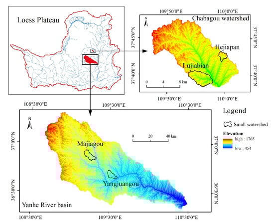
Figure 1.
Location of small watersheds.
2.2. Field Investigation and Classification of Connection Mode
To better understand the different connection modes of check dams with downstream channels, we first carried out a detailed survey of check dams in the above four small watersheds in the field, including the location, DBS, whether the dam body was damaged, the discharge canals and its distribution in the dam land and the interconnection of all the check dams in the dam system of the small watershed. Then the check dams were marked in detail on remote sensing of Google Earth, for facilitating the calculation of later related parameters.
According to the survey results, the connection modes between check dams and downstream channels can be classified into eleven categories: (1) Disconnected (Figure 2a); (2) Connected through spillway (Figure 2b); (3) Connected through shaft (Figure 2c) or horizontal pipe (Figure 2d); (4) Connected through shaft and spillway (Figure 2e), or horizontal pipe and spillway (Figure 2f); (5) Connected through shaft, horizontal pipe and spillway (Figure 2g); (6) Connected through dam body damaged gap (Figure 2h); (7) Connected through discharge canal (DC) (Figure 2i); (8) Connected through discharge canal to shaft (DS1) (Figure 2j); (9) Connected through discharge canal to spillway (DS2) (Figure 2k); (10) Connected through discharge canal to shaft and spillway (DSS) (Figure 2l); (11) Connected through discharge canal to dam body damaged gap (DD) (Figure 2m), and this kind of check dam originally did not have a drainage building, the dam body was damaged and formed a gap during its operation period or a gap was dug in the dam body artificially for the convenience of drainage. Due to the differences in the degree of ecological restoration and check dam management, the number of check dams and connection modes in different watersheds varied greatly.
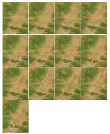
Figure 2.
Different connection modes of check dams with a downstream channel.
2.3. Distribution and Number of Check Dams in four Watersheds
Table 1 and Figure 3 show the number and distribution of check dams in four typical watersheds. There are 8, 29, 49 and 50 check dams in the Hejiapan, Lujiabian, Yangjuangou and Majiagou watersheds, respectively. The number of check dams that were disconnected and connected through discharge canals are the highest, with 38 and 31, respectively, while connected through shaft or horizontal pipe, spillway, dam body damaged gap, DD and DS2 are relatively large, and the remaining are very small.

Table 1.
Number of check dams with different connection modes in the four typical watersheds.
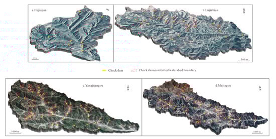
Figure 3.
Distribution of check dams in four typical watersheds.
There are only three connection modes in the Hejiapan watershed, which are disconnected, connected through shaft and DD; the number of disconnected is the highest. There are seven types of connection modes in the Lujiabian watershed; the largest number of connection modes is DD, while the other types are fewer. There are six types of connection modes in the Yangjuangou watershed; the number of disconnected and connected through discharge canal is the largest, with 20 and 23, respectively, while the other types are very few. There are eleven types of connection modes in the Majiagou watershed; the largest number of connection modes are disconnected, connected through shaft or horizontal pipe, spillway and DS2, while the other types are few.
2.4. Evaluation of Structural Connectivity Degree
In general, the area controlled by check dams is the entire area above the dam body in the catchment. In fact, due to the different connection modes of check dams to downstream channels, the actual area controlled by check dams is not the entire area above the dam body. The actual control area of the 1–6 types of connection modes is the entire dam-controlled area, while the 7–11 types of check dam with discharge canal are not the entire dam-controlled area, which is divided into two parts: the dam land-controlled area and the discharge canal-controlled area.
Figure 4 is a schematic diagram of check dams with discharge canals, in which part of the sediment from the slope directly flows into the discharge canal and then is transported to the downstream channel. Therefore, the sediment actually intercepted by the check dam is only from the slope that the dam land-controlled area. Considering that the characteristics of topography and vegetation of the check dam-controlled watershed are not very different, the degree of structural connectivity of the sediment of check dams to downstream channels (SCCD) can be evaluated by the ratio of the actual control area controlled by the discharge canal to the area of the entire area above check dam body in the watershed.
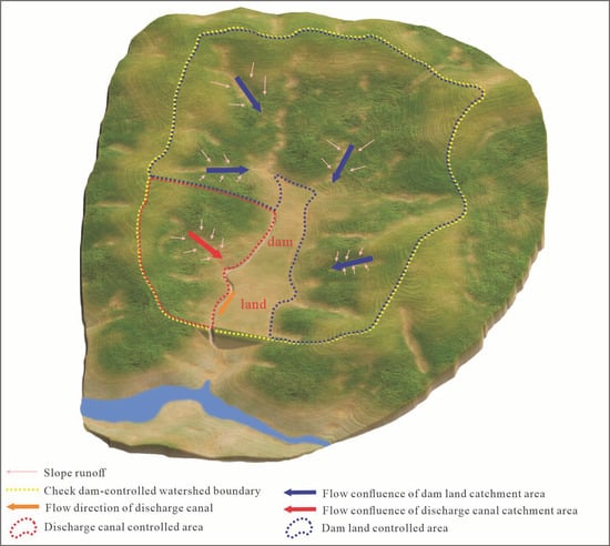
Figure 4.
Check dam connected to the downstream channel through the discharge canal.
The different connection mode types of check dams with downstream channels are identified on the remote sensing image. If there is a discharge canal in the dam land, the check dam-controlled watershed is divided into discharge canal-controlled area and dam land-controlled area. Based on the ArcGIS software platform using Formula (1), the SCCD was calculated.
where SCCD is the degree of structural connectivity of sediment for different connection mode check dams (%), the value of SCCD is between 0% and 100%, the smaller the value, the weaker the degree of connectivity of sediment. Adcc is the discharge canal-controlled area (km2), Acdc is the total area of the check dam-controlled watershed (km2).
According to the monitoring of the sediment in the Chabagou watershed and the Yanhe River basin under the conditions of a single rainfall, the sediment in the dam land has basically been unable to be transported to the dam body under non-rainstorm conditions in recent years [24]. With the restoration of ecology and less human disturbance, there is no sediment transport into the dam land. Therefore, it can be considered that under non-rainstorm conditions, although the check dams with connection modes of types 1–6 are connected to the downstream channel through DBS, their structural connectivity is disconnected. However, for the check dams with connection mode of types 7–11, sediment from the slope will be transported through the discharge canal to the downstream channel even under non-rainstorm conditions.
3. Results
3.1. Connection Mode and Degree
Table 2 shows the average SCCD of different connection modes of check dams in the four watersheds. From the perspective of different connection modes, check dams without drainage canals are disconnected, while check dams with discharge canals have different combinations of DBS and dam body damaged gap, resulting in a difference of the SCCD. The order of the average SCCD of check dams with discharge canal is: DSS > DS2 > DC > DD > DS1. The average SCCD of check dam with DS1 is the smallest, only 5.32%. While the average SCCD of check dam with DD and DC is 49.83% and 50.06%, respectively. The average SCCD of check dams with DSS and DSS2 is relatively high, 61.63% and 53.36%, respectively. It is for this reason that check dams of these two types have a longer operation time, which makes the discharge canal longer, and leads to a lower actual control area of dam land.
Table 2.
Average SCCD of different connection modes in the four watersheds.
From the perspective of the four watersheds, the average SCCD of check dams in the Hejiapan watershed accounted for the lowest percentage, only 1.13%. The reason is that the average actual control area percentage of the discharge canal is very low. The average SCCD of check dams in the Yangjuangou watershed and the Majiagou watershed is 19.11% and 22.20%, respectively. The average SCCD of the Lujiabian watershed is the largest, at 27.89%. Although the average SCCD of check dams connected through DD and DS2 ate both less than 60%, the average SCCD of check dams with only a discharge canal is 82.36%, resulting in the actual control area of discharge canal accounting for the largest proportion among the four watersheds. Therefore, if the structural connectivity of the sediment of the four watersheds is ranked by the average SCCD of check dams, the order is Lujiabian > Majiagou > Yangjuangou > Hejiapan. The SCCD is mainly affected by the length of discharge canal, and the length of the discharge canal is ultimately affected by the management degree of check dams. Due to the long operating life of the check dams in the Yangjuangou watershed, coupled with inadequate management, the check dams are generally damaged, many shafts, horizontal pipes and spillways have been completely destroyed or buried, resulting in a small number of check dams with drainage building or spillway. Although the number of check dams with discharge canals is relatively large, accounting for 55.10%, the length of the discharge canal is short, and the actual control area percentage of the discharge canal is relatively low. On the contrary, check dams of the Lujiabian watershed and the Majiagou watershed have better management, the number of check dams with a discharge canal is also large, accounting for 65.52% and 46.00%, respectively, and the length of the discharge canal is longer, the actual control area percentage of discharge canal is higher. Therefore, in order to reduce SCCD, the management of check dams should not only pay attention to the safe operation of check dams but also avoid the existence of discharge in the dam land or ensure the discharge canal is as short as possible.
3.2. Degree of Structural Connectivity for Dam System
The dam systems have been formed on the Loess Plateau [26], and the dam systems are composed of check dams with different connection modes. Whether they are series, parallel or hybrid dam systems, the connection mode is more complicated and variable (Figure 5).
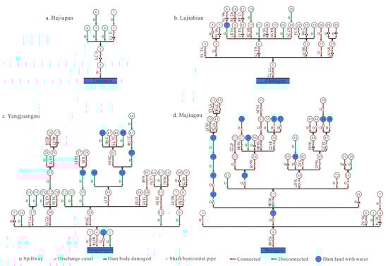
Figure 5.
Position and connection modes of check dams in the four watersheds (the number is the SCCD of each check dam).
According to the different cascade modes of each dam system, the dam system of the four watersheds can be divided into 27 small dam systems, and the area of each dam system ranges from 0.82 to 71.50 km2, with an average value of 14.25 km2. The SCCD of a single check dam is between 2.33% and 66.41%, with an average of 27.53%. While the SCCD of each small dam system is between 0% and 42.38%, with an average of 11.18% (Table 3). According to the different connection modes of each check dam in small dam systems, the connection modes of dam systems can be divided into four categories: (1) Check dam at the bottom of the dam system has a discharge canal, and if the upstream check dam has a discharge canal, it must be connected to the check dam at the bottom of the dam system (dam systems #4, #11, #23 and #24). (2) Check dam at the bottom of the dam system has a discharge canal, but other check dams upstream have no discharge canal (dam systems #5, #7 and #9). (3) Check dams upstream and at the bottom of the dam system have discharge canals, but the check dams between the upstream and the bottom of the dam system have no discharge canals, which leads to the upstream check dam not being connected to the check dam at the bottom of the dam system (dam systems #3, #6, #8, #10, #13, #17, #20, #21, #25 and #27). (4) Check dam at the bottom of the dam system has no discharge canal, while some other check dams have discharge canals (dam systems #1, #2, #9, #12, #14, #15, #16, #18, #22 and #26). Compared with the SCCD of a single dam, the SCCD of the first two types of dam systems have not changed, the SCCD of the third type of dam system decreases 1.76–22.56%, with an average of 10.03%, and the last type of dam system decreases 2.33–42.38%, with an average of 20.15%.
Table 3.
SCCD of the sum of a single check dam and dam system in the four watersheds.
Therefore, if the four types of dam systems are ranked according to the reduction degree of SCCD, the order is (4) > (3) > (2) = (1). If the check dam at the bottom of the dam system has no discharge canal, the SCCD of the dam system has decreased the most, and it is possible to intercept all the sediment from the whole catchment above under non-rainstorm conditions so as to maximize the sediment interception efficiency of the dam system. The SCCD of the other three types of connection modes with a discharge canal have not changed or are little changed. Therefore, the SCCD of a dam system is less than or equal to that of the sum of a single check dam; and the SCCD depends on the connection mode between check dams and downstream channels in the watershed.
4. Discussion
4.1. The Effect of Connection Mode on Structural Connectivity of Sediment
It is convenient to quantitatively evaluate the SCCD by using the actual control area percentage of the discharge canal. The higher the SCCD, the lower the sediment interception efficiency. At the same time, the influence of the height difference between dam land and the outlet of DBS was considered, which can also reflect the functional connectivity of sediment between the check dam and the downstream channel to a certain extent. Gao et al. [16] defined the degree of check dam connected to the downstream channel through a spillway is strong, but through shaft or horizontal pipe is weak. Hassanli et al. [27] also reported that the sediment interception efficiency of a check dam built with broken and angular rocks is higher than that built with rounded rocks, which is actually a combination of structural connectivity and functional connectivity to measure the degree of connectivity between a check dam and downstream channel. It was considered that the degree of connectivity depends on the outlet size of drainage facilities, which has certain limitations, and the influence of a discharge canal is not considered.
From the number of different connection modes between check dams and the downstream channel in the four small watersheds, it can be seen that the number of disconnected and connected (connected through the spillway, shaft, horizontal pipe and dam body damaged gap) are 38 and 35, respectively, accounting for 27.94% and 25.74%, respectively. Among them, the sediment interception efficiency of the check dam that is disconnected is 100%, and the sediment interception efficiency of check dam with a shaft, horizontal pipe, spillway and dam body damaged gap is also 100% if the sediment is not transported to the dam body. However, even if the sediment is not transported to the dam body, the sediment on the slope controlled by the discharge canal will not be intercepted in the dam land but will be directly transported to the downstream channel through the discharge canal. While there are 63 check dams with a discharge canal, accounting for 46.32% of the total, the average SCCD of the 63 check dams with a discharge canal is 50.71%, which shows that the existence of a discharge canal in the dam land has a great influence on the structural connectivity of check dams, and also affects the functional connectivity.
In fact, the connection mode between check dams and a downstream channel is not fixed; natural factors, such as rainfall, and human factors, such as lack of management, will cause changes in the connection mode, especially in the Loess Plateau, due to frequently occurring short heavy rainfall, which provides more possibilities for the changes [28,29,30]. If the check dam is disconnected from the downstream channel is damaged in extreme rainfall, it would be connected to the downstream channel through the dam body damaged gap; the check dams connected through DBS would also become the check dams connected through the dam body damaged gap due to the drainage buildings or spillway being damaged [31].
If the headrace is formed in dam land after a long period of erosion, the connection mode will be changed: the headrace becomes the discharge canal, and a check dam without a discharge canal is transformed into a check dam with a discharge canal. According to the field surveys, it is found that the discharge canal in small and medium-sized check dams only plays the role of sediment discharge, which has little influence on the dam land area (Figure 6). While drainage channels of some check dams will encroach and shrink the dam land area (Figure 7) and will not intercept sediment, some will become the sediment source with aggravating erosion [27] and promoting sediment connectivity [12].
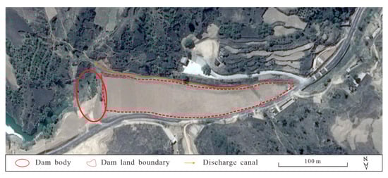
Figure 6.
Check dam with a discharge canal.
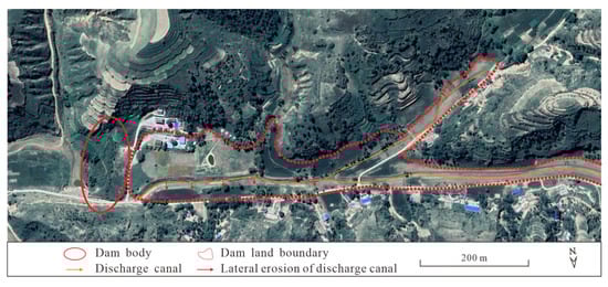
Figure 7.
Discharge canals can encroach and shrink dam land area.
4.2. Optimization of Connection Mode in Dam System
From the analysis of structural connectivity of the small watersheds in this study, it can be seen that the degree of structural connectivity of dam systems will be less than the sum of single check dams. The larger dam systems in a watershed are composed of different small dam systems, and the cascade modes of the small dam systems include series, parallel and hybrid. The layout of a dam system can adjust the water and sediment process by changing the degree of connectivity of channels. The simulation results with the MIKE model show that different cascade modes of dam systems have different degrees of attenuation on flood peak and total flood discharge: hybrid > parallel > series [32]. Zhang et al. [33] also reported that hybrid and parallel systems, as well as check dams with DBS, had better flood control capacity. In fact, this mainly focuses on the functional connectivity of dam systems and does not consider the influence of the structural connectivity of check dams and downstream channels separately. If the structural connectivity is considered, the degree of sediment connectivity and sediment interception efficiency of check dams are irregular, which is mainly affected by the connection mode.
The Hejiapan and Lujiabian watersheds are mainly parallel dam systems due to the low level of gully, while the Yangjuangou and Majiagou watersheds area mainly hybrid dam systems due to the high level of gully. It is necessary to evaluate the connection mode of each small dam system and consider the influence of different cascade modes on the structural connectivity in the whole watershed when optimizing the connection mode of check dams. The difference in connection modes and their combinations will lead to great differences in the degree of connectivity and sediment interception efficiency of the whole dam system.
Ideally, if all the check dams are not connected with the downstream channels, the sediment interception efficiency of the whole dam system will be 100%. In fact, spillway, shaft and horizontal pipes should be configured according to the actual situation and the construction requirements of check dams when building check dams, and with the extension of the operation time of check dams, the formation of gap due to the dam body was damaged, and the formation of a discharge canal in the dam land is inevitable [31], which eventually leads to various connection modes between the check dam and the downstream channel, and the degree of structural connectivity is mainly affected by the discharge canal. The existence of a discharge canal leads to the reduction of the actual control area of the check dam, thus increasing the degree of structural connectivity.
The design of connection modes between a check dam and downstream channel should follow the principles: the check dam must not be at the risk of dam-break under extreme rainstorm conditions but should ensure the connectivity between the check dam and downstream channel, and the excess water and sediment can be transported to the downstream channel in time, thus ensuring the safe operation of a single check dam and the dam system, minimizing the structural connectivity between check dam and downstream channel, and retaining water and sediment in the dam land as much as possible under extreme rainstorm conditions. Therefore, two preconditions should be followed: (1) all check dams in the dam system should have DBS and ensure the outlet of the drainage building is not blocked. Otherwise, check dams would be easily damaged under extreme rainfall conditions. For example, in the “7·26” extreme rainstorm, the dam body was intact when the discharge outlet of the shaft was opened in time, while some check dams were damaged due to the discharge outlets of the shaft were blocked [19,34]. (2) The discharge canal should be avoided in the dam land, and its length should be kept as short as possible, especially in a large check dam-controlled watershed.
For example, in Figure 8: Check dams (#6 and #9) at the top of the series of dam systems (#6→#5→#4 and #9→#8) and check dam (# 5) between the top and the bottom of the series dam system can be the check dam with DBS or a discharge canal, and check dams (#4 and #8) at the bottom of the series dam system can be a check dam with only DBS. The advantage of this design is that, because the check dam at the bottom of the series dam system has no discharge canal, the actual control area of the check dam is still the area of the whole check dam-controlled watershed; that is, the SCCD is minimized.
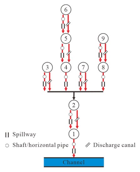
Figure 8.
Optimal connection mode in a dam system (the shaft, horizontal pipe and spillway can be in separate or combined forms).
Parallel dam systems can be divided into two situations: (1) The parallel check dams are all single check dams, and there are no other check dams upstream (#3 and #7), these single check dams are connected to a downstream channel through DBS or discharge canal. (2) Series dam systems and single check dams together form a parallel dam system (#3, #6→#5→#4, #7 and #9→#8). The series dam system is configured with the principle of a series dam system, while the single check dam is configured with the connection mode according to the principle of (1).
The series and parallel dam systems are combined to form smaller hybrid dam systems, and the smaller hybrid dam systems further constitute the larger hybrid dam systems, in which the connected mode should be optimized with reference to the principle of the series and parallel dam systems. However, it should be noted that no matter whether it is the small or the large hybrid dam system, the bottom key check dam (#1) is very important for the structural connectivity of sediment in the whole dam system [27]. The key check dam should not have a discharge canal and only be connected to the downstream channel through DBS, and if there have other check dams connected to the key check dam in series upstream (#2), these check dams can only have a discharge canal or DBS.
5. Conclusions
Based on the field survey, the connection modes between check dams and downstream channels are divided into eleven categories. The degree of structural connectivity of sediment between the check dam and downstream channel was quantitatively evaluated according to the actual control area percentage of the discharge canal. When the sediment cannot be transported to the dam body under non-rainstorm conditions, the order of the structural connectivity of sediment of the 11 connection modes is: Disconnected = shaft or horizontal pipe = spillway = shaft and spillway, or horizontal pipe and spillway = shaft, horizontal pipe and spillway = dam body damaged gap < discharge canal to shaft < discharge canal to dam damage gap < discharge canal < discharge canal to spillway < discharge canal to shaft and spillway. The different connection modes and combination forms of check dams lead to a great difference in structural connectivity of dam systems, the structural connectivity of the dam system is less than or equal to that of the sum of single check dams. The degree of structural connectivity of a dam system will be greatly reduced if the main control check dam of the dam system has no discharge canal. The optimization method of the connection mode of the series, parallel and hybrid dam systems is proposed according to the different cascade modes of dam systems. This study only discusses the structural connectivity of sediment of single check dams and dam systems, and the evaluation of functional connectivity based on structural connectivity needs to be further analyzed in future research.
Author Contributions
Conceptualization, L.B. and J.J.; investigation, all authors; data curation, L.B.; writing—original draft preparation, L.B.; writing—review and editing, all authors. All authors have read and agreed to the published version of the manuscript.
Funding
This study was supported by Open Project Fund of Key Laboratory of the Loess Plateau Soil Erosion and Water Loss Process and Control, Ministry of Water Resources (Grant Number 2019001) and National Natural Science Foundation of China (Grant Number 41771319, 42077078).
Institutional Review Board Statement
Not applicable.
Informed Consent Statement
Not applicable.
Data Availability Statement
The data presented in this study are available on request from the corresponding author.
Acknowledgments
The authors are grateful to the Editor and reviewers for their constructive comments and suggestions.
Conflicts of Interest
The authors declare no conflict of interest.
References
- Ministry of Water Resources of the People’s Republic of China. Zhongguo Heliu Nisha Gongbao; China Water&Power Press: Beijing, China, 2020.
- García-Ruiz, J.M.; Beguería, S.; Nadal-Romero, E.; González-Hidalgo, J.C.; Lana-Renault, N.; Sanjuán, Y. A meta-analysis of soil erosion rates across the world. Geomorphology 2015, 239, 160–173. [Google Scholar] [CrossRef] [Green Version]
- Shi, Z.H.; Song, C.Q. Water erosion processes: A historical review. J. Soil Water Conserv. 2016, 30, 1–10. [Google Scholar] [CrossRef]
- García-Ruiz, J.M.; Beguería, S.; Lana-Renault, N.; Nadal-Romero, E.; Cerdà, A. Ongoing and emerging questions in water erosion studies. Land Degrad. Develop. 2017, 28, 5–21. [Google Scholar] [CrossRef]
- Marchamalo, M.; Hooke, J.M.; Sandercock, P.J. Flow and sediment connectivity in semi-arid landscapes in SE Spain: Patterns and controls. Land Degrad. Develop. 2016, 27, 1032–1044. [Google Scholar] [CrossRef]
- Xu, X.Z.; Zhang, H.W.; Zhang, O.Y. Development of check-dam systems in gullies on the Loess Plateau, China. Environ. Sci. Policy. 2004, 7, 79–86. [Google Scholar] [CrossRef]
- Liu, X.Y.; Gao, Y.F.; Ma, S.B.; Dong, G.T. Sediment reduction of warping dams and its timeliness in the Loess Plateau. SHUILI XUEBAO 2018, 49, 145–155. [Google Scholar] [CrossRef]
- Chen, Z.Y.; Li, Z.B.; Wang, Z.Y. Some thoughts on the strategic positioning of check dam construction in the Loess Plateau. Soil Water Conserv. China. 2020, 9, 32–38. [Google Scholar] [CrossRef]
- Li, J.Z.; Liu, L.B. Analysis on the sediment retaining amount by warping dams above Tongguan section of the Yellow River in recent years. Yellow River 2018, 40, 1–6. [Google Scholar] [CrossRef]
- Conesa-García, C.; García-Lorenzo, R. Bed texture changes caused by check dams on ephemeral channels in Mediterranean semiarid environments. Z. Geomorpho. 2008, 52, 437–461. [Google Scholar] [CrossRef]
- Zema, D.A.; Bombino, G.; Denisi, P.; Lucas-Borja, M.E.; Zimbone, S.M. Evaluating the effects of check dams on channel geometry, bed sediment size and riparian vegetation in Mediterranean mountain torrents. Sci. Total Environ. 2018, 642, 327–340. [Google Scholar] [CrossRef] [PubMed]
- Galia, T.; Škarpich, V.; Ruman, S. Impact of check dam series on coarse sediment connectivity. Geomorphology 2021, 377, 107595. [Google Scholar] [CrossRef]
- Surian, N.; Ziliani, L.; Comiti, F.; Comiti, F.; Lenzi, M.A.; Mao, L. Channel adjustments and alteration of sediment fluxes in gravel-bed rivers of North-Eastern Italy: Potentials and limitations for channel recovery. River. Res. Applic. 2010, 25, 551–567. [Google Scholar] [CrossRef]
- Wang, H.W.; Kondolf, G.M. Upstream sediment-control dams: Five decades of experience in the rapidly eroding Dahan River basin, Taiwan. J. Am. Water Resour. Assoc. 2014, 50, 735–747. [Google Scholar] [CrossRef]
- Marchi, L.; Comiti, F.; Crema, S.; Cavalli, M. Channel control works and sediment connectivity in the European Alps. Sci. Total Environ. 2019, 668, 389–399. [Google Scholar] [CrossRef] [PubMed]
- Gao, H.D.; Jian, L.L.; Li, Z.B.; Xu, G.C.; Zhao, B.H. Mechanism underlying impact of check damson runoff based graph theory in the hilly-gully loess region. Sci. Soil Water Conserv. 2015, 13, 1–8. [Google Scholar] [CrossRef]
- Wei, X.; Li, Z.B.; Shen, B.; Li, X.G.; Li, P. The water damage and the prevention measures in construction of check dam. J. Water Resour. Water Eng. 2004, 15, 55–59. [Google Scholar]
- Wang, Z.L.; Zhang, B.S.; Liu, H.Z.; Li, C.J.; Lin, X.Z.; Yang, J.S. Damage causes and sand-blocking effects of warping dams in Dalat Banner in 2016. Adv. Sci. Technol. Water Resour. 2019, 39, 1–6. [Google Scholar] [CrossRef]
- Wang, N.; Chen, Y.X.; Bai, L.C.; Wang, H.L.; Jiao, J.Y. Investigation on soil erosion in small watersheds under “7·26” extreme rainstorm in Zizhou county, northern Shaanxi province. Bull. Soil Water Conserv. 2017, 37, 338–344. [Google Scholar] [CrossRef]
- Yu, G.Q.; Zhang, M.S.; Li, Z.B.; Li, P.; Zhang, X.; Cheng, S.D. Piecewise prediction model for watershed-scale erosion and sediment yield of individual rainfall events on the Loess Plateau, China. Hydrol. Process. 2015, 28, 5322–5336. [Google Scholar] [CrossRef]
- Yang, J.S.; Yao, W.Y.; Zheng, M.G.; Li, L. Analysis on gravitational sediment yield in the check-dam controlled basins of Chabagou watershed. SHUILI XUEBAO 2017, 48, 241–245. [Google Scholar] [CrossRef]
- Li, C.Z.; Wang, H.; Yu, F.L.; Yang, A.M.; Yan, D.H. Impact of soil and water conservation on runoff and sediment in Yanhe River basin. Sci. Soil Water Conserv. 2011, 9, 1–8. [Google Scholar] [CrossRef]
- Wang, H.L.; Jiao, J.Y.; Tang, B.Z.; Chen, Y.X.; Bai, L.C.; Wang, N.; Zhang, Y.F. Characteristics of rill erosion and its influencing factors in slope farmland after “7·26” rainstorm in Zizhou County, Shaanxi Province. Trans. Chin. Soc. Agric. Eng. 2019, 35, 122–130. [Google Scholar] [CrossRef]
- Bai, L.C.; Wang, N.; Jiao, J.Y.; Chen, Y.X.; Tang, B.Z.; Wang, H.L.; Chen, Y.X.; Yan, X.Q.; Wang, Z.J. Soil erosion and sediment interception by check dams in a watershed for an extreme rainstorm on the Loess Plateau, China. Int. J. Sediment Res. 2020, 35, 408–416. [Google Scholar] [CrossRef]
- Yu, H. The period and trend analysis of streamfall and sediment load in yan river based on time series. Master’s Thesis, Northwest Agricultural and Forestry University, Yangling, China, 2008. [Google Scholar]
- Yu, T.; Li, Z.B.; Chen, Y.T.; Yuan, S.L.; Wang, W. Analysis of structural characteristics of typical check dam system in the third subregion of loess hilly region. Res. Soil Water Conserv. 2019, 26, 26–30. [Google Scholar] [CrossRef]
- Hassanli, A.M.; Nameghi, A.E.; Beecham, S. Evaluation of the effect of porous check dam location on fine sediment retention (a case study). Environ. Monit. Assess. 2009, 152, 319–326. [Google Scholar] [CrossRef] [PubMed]
- Wei, X.; Li, Z.B.; Wu, J.H.; Li, B.B.; Du, Z. A Discussion on some deological problems in research of water damage hazards of check dam. Res. Soil Water Conserv. 2007, 14, 235–237. [Google Scholar]
- Luo, Z.B.; Yong, C.X.; Fan, J.; Shao, M.A.; Wang, S.; Jin, M. Precipitation recharges the shallow groundwater of check dams in the loessial hilly and gully region of China. Sci. Total Environ. 2020, 742, 140625. [Google Scholar] [CrossRef]
- Jiao, J.Y.; Wang, Z.J.; Wei, Y.H. Characteristics of erosion sediment yield with extreme rainstorms in Yanhe Watershed based on field measurement. Trans. Chin. Soc. Agric. Eng. 2017, 33, 159–167. [Google Scholar] [CrossRef]
- Li, L.; Wang, F.; Sun, W.Y.; Shi, X.J. Analysis of water damage of check dam in Loess Plateau. Soil Water Conserv. China 2014, 10, 20–22. [Google Scholar] [CrossRef]
- Yuan, S.L.; Li, Z.B.; Li, P.; Gao, H.D.; Wang, D.; Zhang, Z.Y. MIKE coupling model simulating effect of check dam construction on storm flood process in small watershed. Trans. Chin. Soc. Agric. Eng. 2018, 34, 152–159. [Google Scholar] [CrossRef]
- Zhang, Y.F.; Jiao, J.Y.; Tang, B.Z.; Chen, Y.X.; Wang, N.; Bai, L.C.; Wang, H.L. Channel sediment connectivity and influence factors in small watersheds under extremely rainstorm–a case study at Zizhou county, Shaanxi province. Bull. Soil Water Conserv. 2019, 39, 302–309. [Google Scholar] [CrossRef]
- Zhou, Z.Y.; Wang, X.L.; Chen, W.L.; Deng, S.H.; Liu, M.H. Numerical simulation of dam-break flooding of cascade reservoirs. Trans. Tianjin Univ. 2017, 23, 570–581. [Google Scholar] [CrossRef]
Publisher’s Note: MDPI stays neutral with regard to jurisdictional claims in published maps and institutional affiliations. |
© 2021 by the authors. Licensee MDPI, Basel, Switzerland. This article is an open access article distributed under the terms and conditions of the Creative Commons Attribution (CC BY) license (https://creativecommons.org/licenses/by/4.0/).