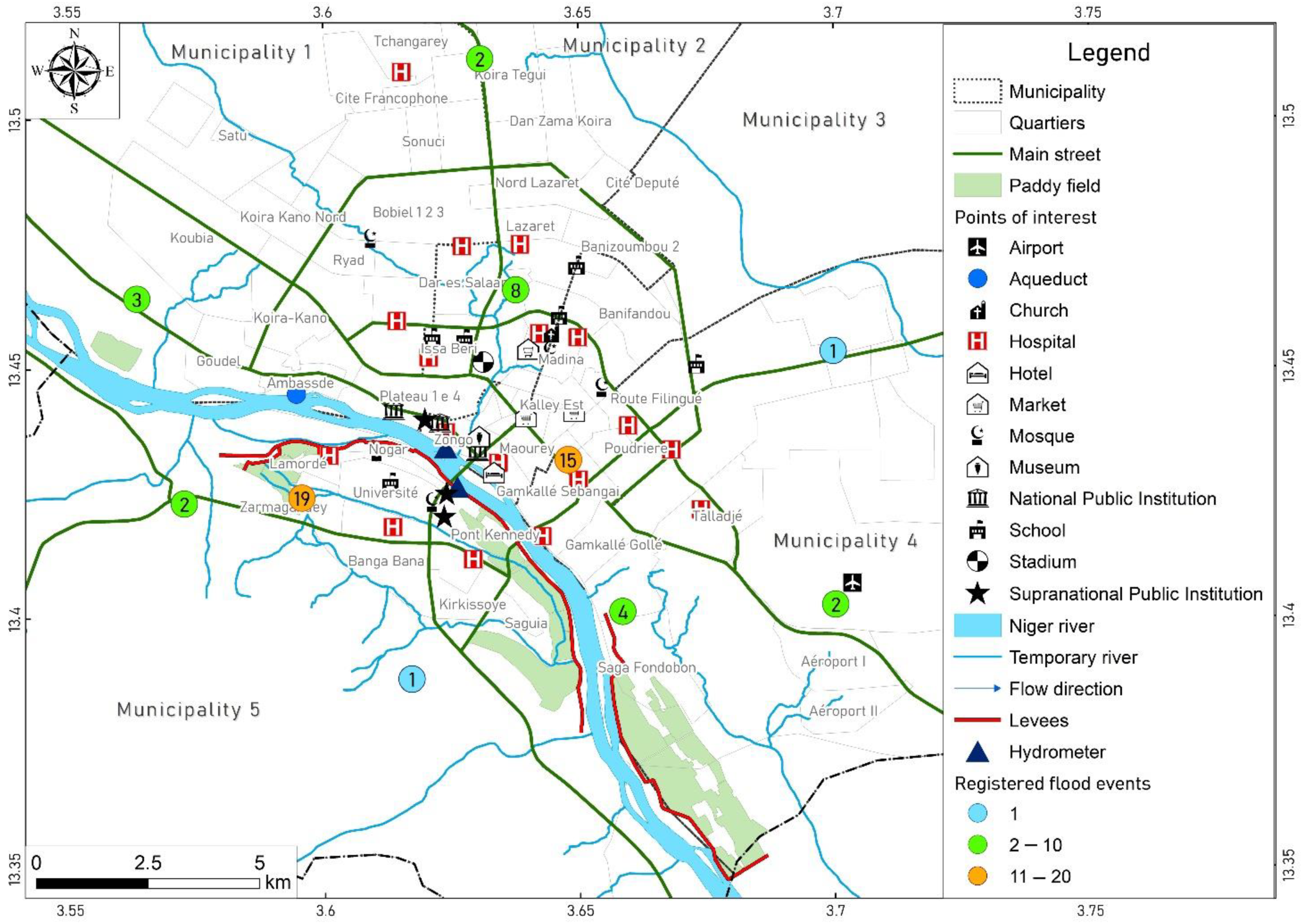
Figure 1.
Map of the Niamey city with fluvial and pluvial flood events registered between 1998 and 2019 (Source BDINA-Base de Données sur les Inondations au Niger ANADIA [
30]).
Figure 1.
Map of the Niamey city with fluvial and pluvial flood events registered between 1998 and 2019 (Source BDINA-Base de Données sur les Inondations au Niger ANADIA [
30]).
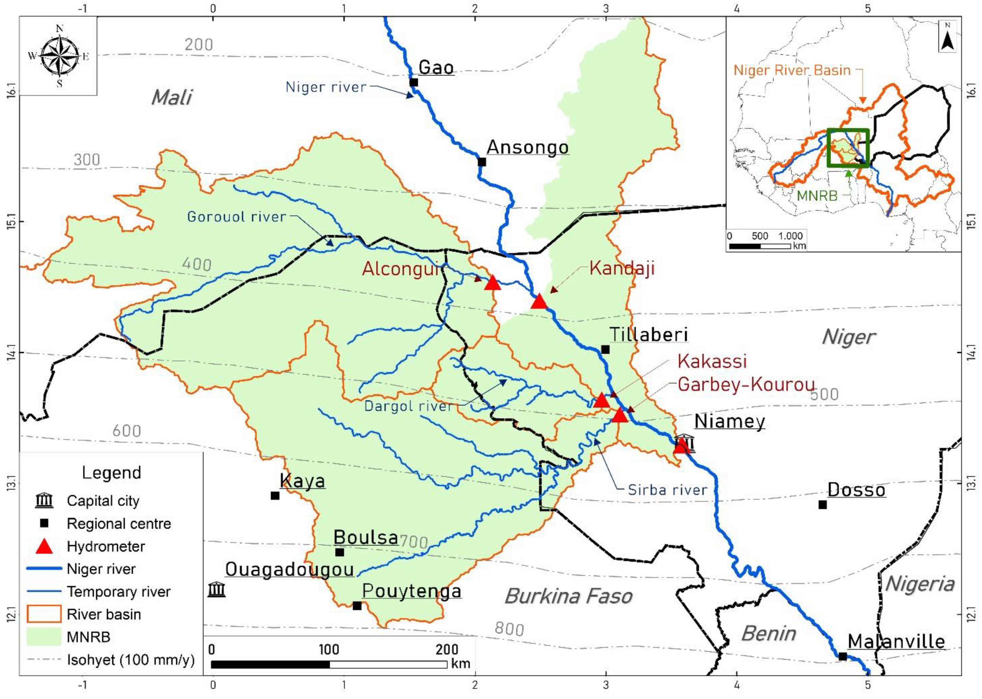
Figure 2.
Map of Middle Niger River Basin (MNRB).
Figure 2.
Map of Middle Niger River Basin (MNRB).
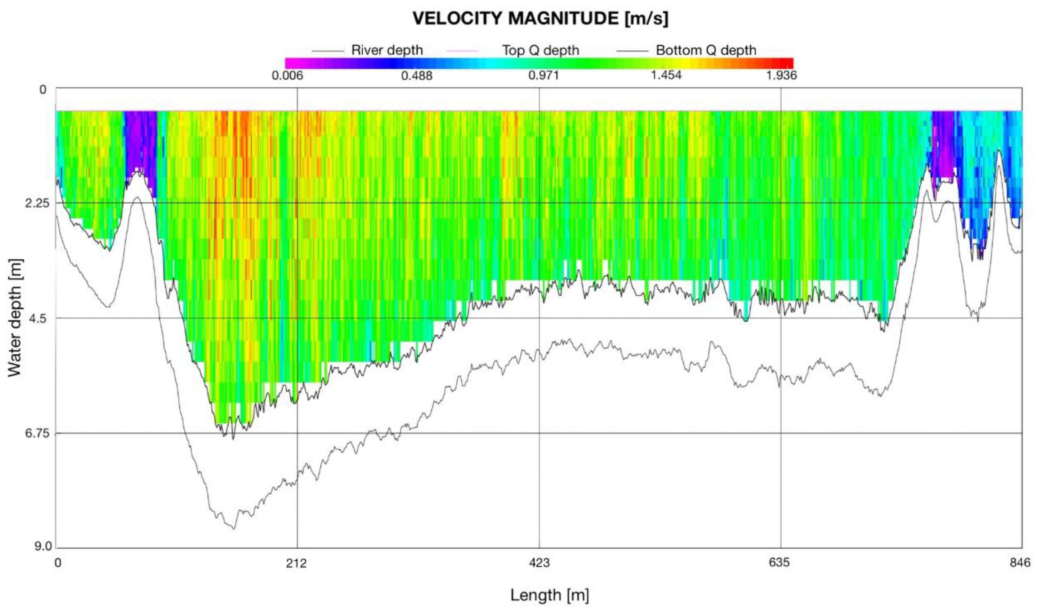
Figure 3.
Acoustic Doppler Current Profiler (ADCP) observation conducted in the Niger River in Niamey (Soumana section) on 8 September 2020 with a flow depth of 698 cm (2850 m3/s).
Figure 3.
Acoustic Doppler Current Profiler (ADCP) observation conducted in the Niger River in Niamey (Soumana section) on 8 September 2020 with a flow depth of 698 cm (2850 m3/s).
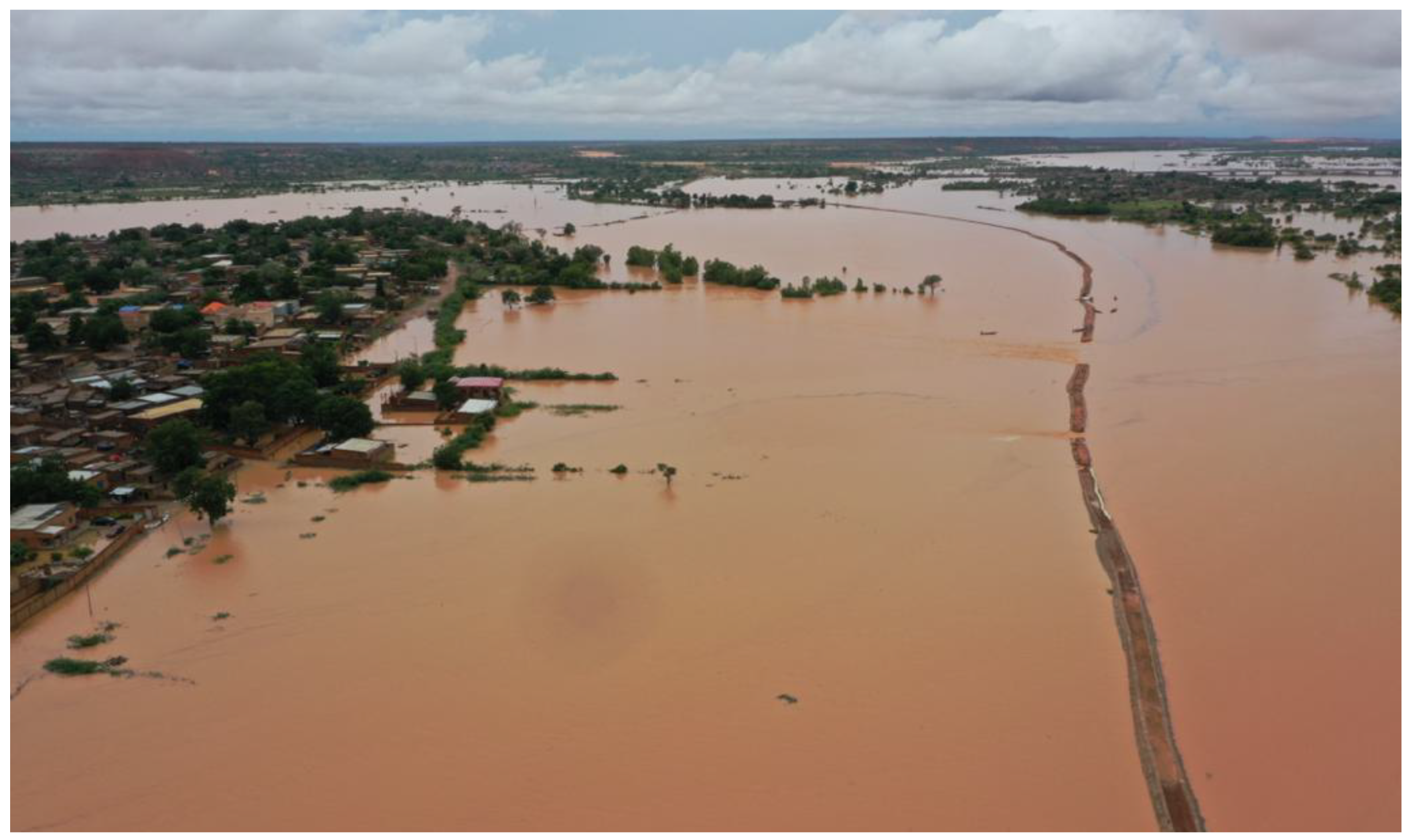
Figure 4.
The Niger River in Niamey on 7 September 2020: The Lamordé levee and district on the right bank from the downstream aerial point of view (Author: Direction Générale de la Protection Civile du Niger).
Figure 4.
The Niger River in Niamey on 7 September 2020: The Lamordé levee and district on the right bank from the downstream aerial point of view (Author: Direction Générale de la Protection Civile du Niger).
Figure 5.
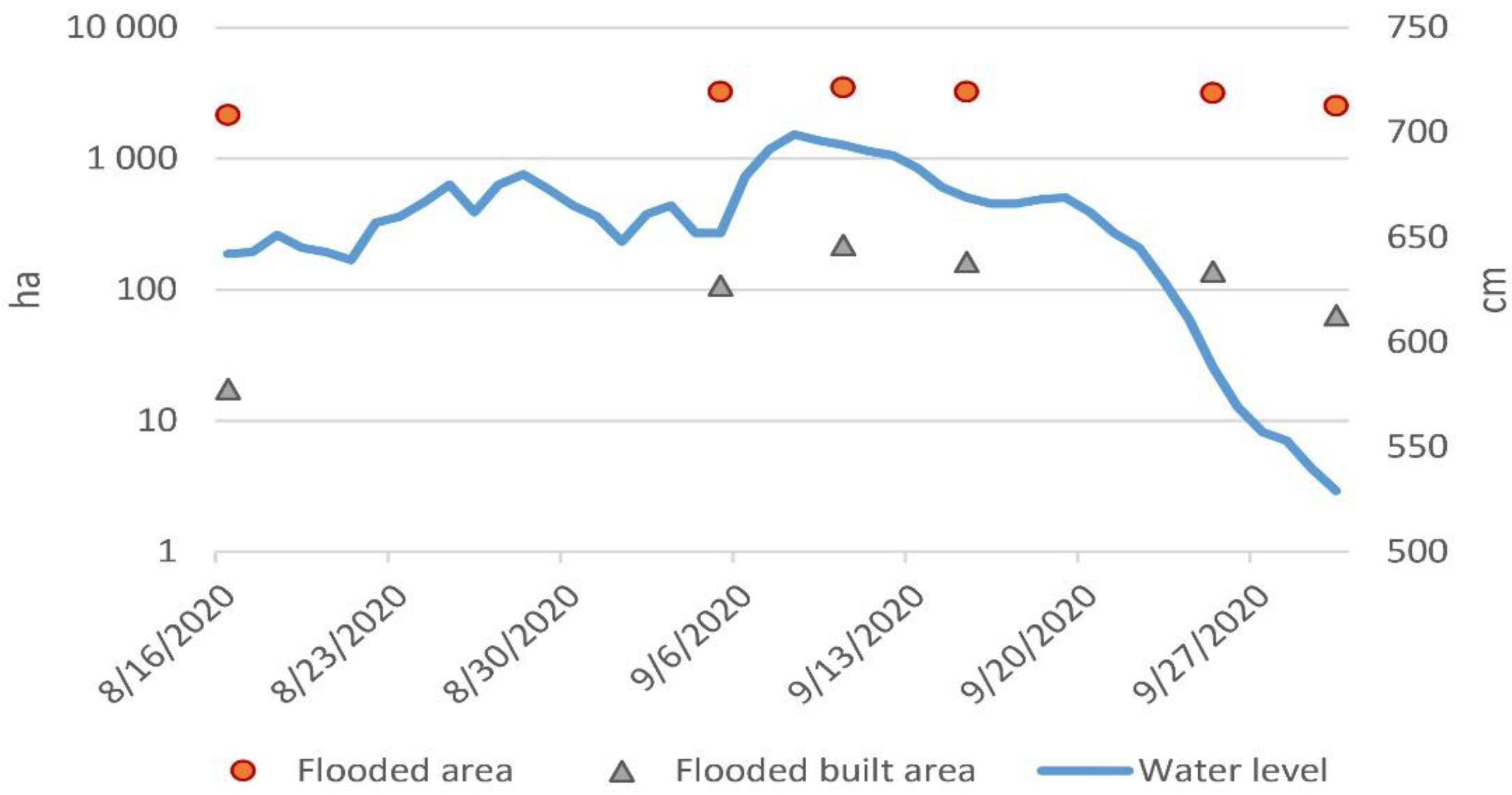
Evolution of flooded areas in Niamey during the 2020 flood (21/8, 26/8, 31/8 and 20/9 images were not usable due to cloud coverage).
Figure 5.
Evolution of flooded areas in Niamey during the 2020 flood (21/8, 26/8, 31/8 and 20/9 images were not usable due to cloud coverage).
Figure 6.
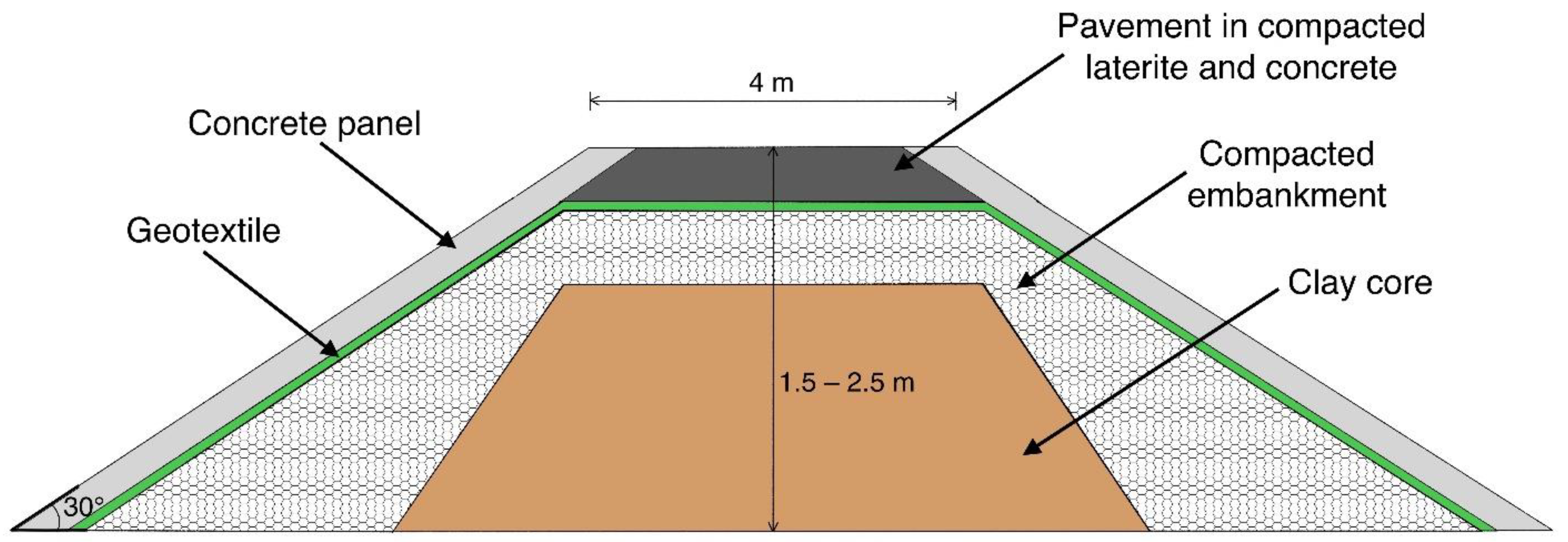
The cross−section of Niamey levees in the Lamordé (sector A) and Saga (sector D).
Figure 6.
The cross−section of Niamey levees in the Lamordé (sector A) and Saga (sector D).
Figure 7.
The Niamey levees during the 2019 and 2020 flood events: (A)(top-left) the bridges levee (sector B) raise with sandbags on 18/8/20 (h = 651 cm), (B)(top-right) the levee break in Lamordé (Sector A) on 6/9/20 (h = 679 cm), (C)(bottom-left) aerial view of Kirkissoie levee on 30/8/19 (h = 619 cm), (D)(bottom-right) aerial view of Saga levee on 30/8/19 (h = 619 cm).
Figure 8.
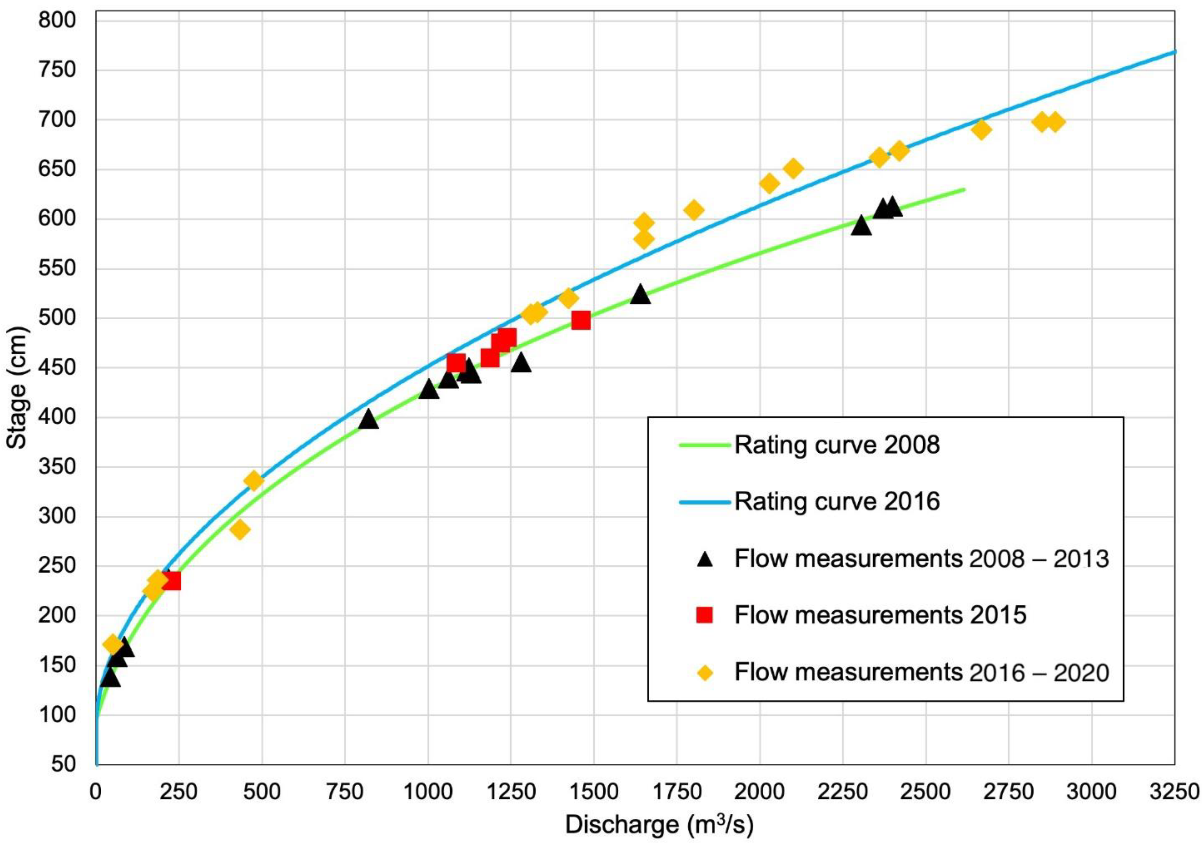
Comparison between the rating curves 2008 (green) and 2016 (blue) and the flow measurements: 2008–2013 (black triangle), 2015 (red square) and 2016–2020 (orange diamond).
Figure 8.
Comparison between the rating curves 2008 (green) and 2016 (blue) and the flow measurements: 2008–2013 (black triangle), 2015 (red square) and 2016–2020 (orange diamond).
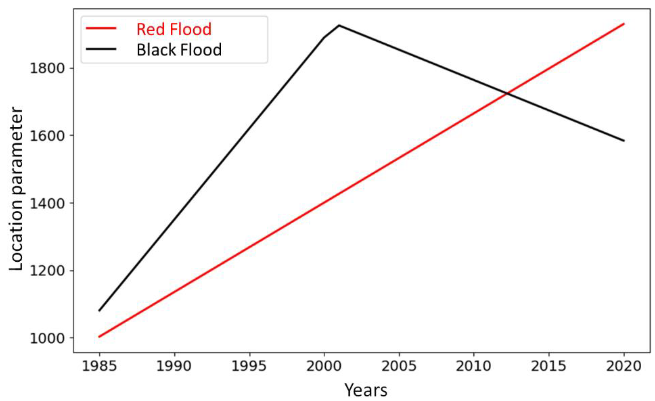
Figure 9.
Evolution of return levels for three return periods (2, 10 and 100 years): (A) (left) black and (B) (right) red floods in the Niamey City.
Figure 9.
Evolution of return levels for three return periods (2, 10 and 100 years): (A) (left) black and (B) (right) red floods in the Niamey City.
Figure 10.
Evolution of return period associated to the flows of actual hazard-thresholds in the Niamey City.
Figure 10.
Evolution of return period associated to the flows of actual hazard-thresholds in the Niamey City.
Figure 11.
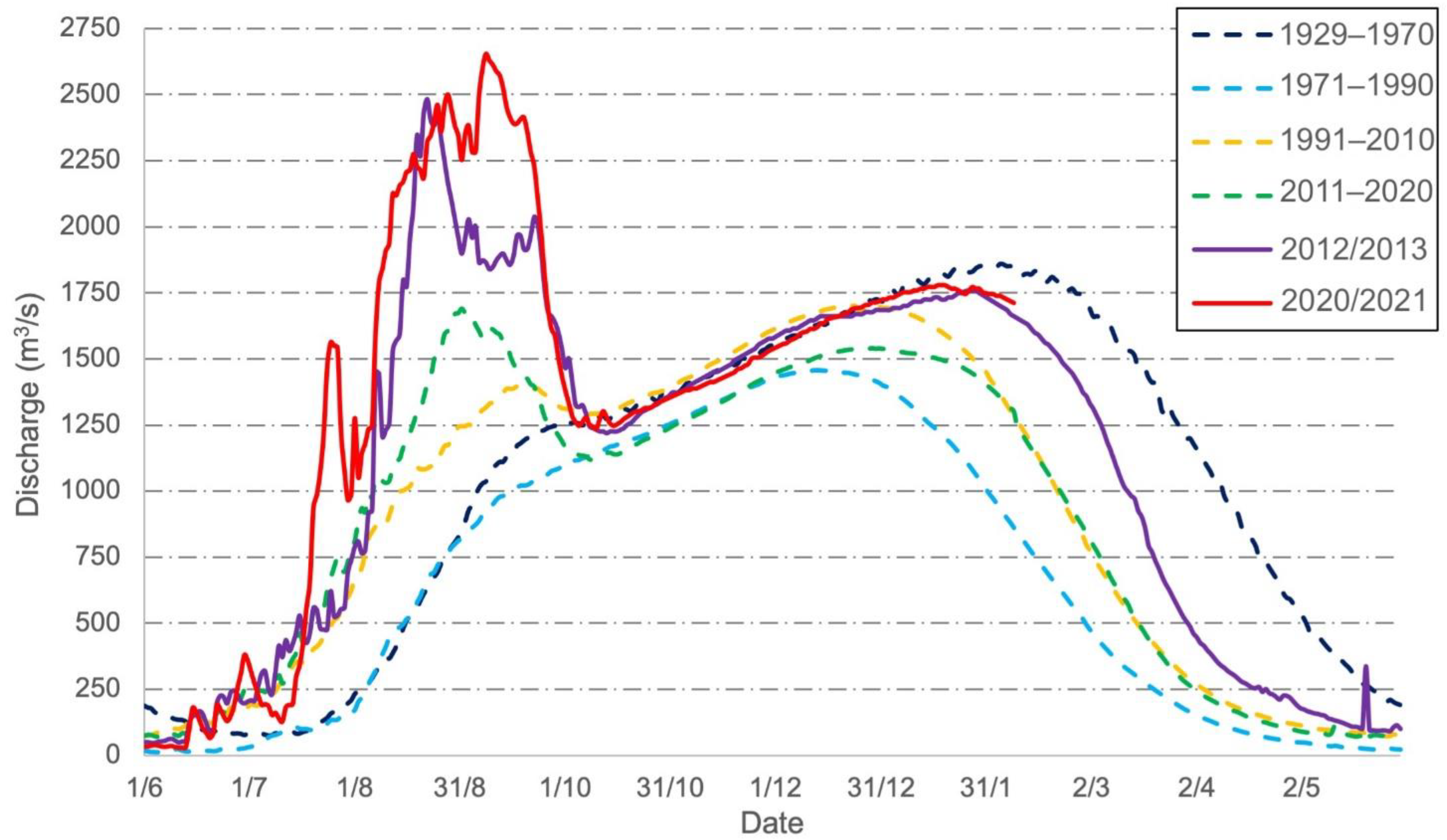
Mean intra-annual hydrographs (the hydrological year starts on 1 June and ends on 31 May) of Niger River in Niamey: the four hydrological periods (1929–1970, 1971–1990, 1991–2010, and 2011–2020) and the catastrophic years 2012 and 2020.
Figure 11.
Mean intra-annual hydrographs (the hydrological year starts on 1 June and ends on 31 May) of Niger River in Niamey: the four hydrological periods (1929–1970, 1971–1990, 1991–2010, and 2011–2020) and the catastrophic years 2012 and 2020.
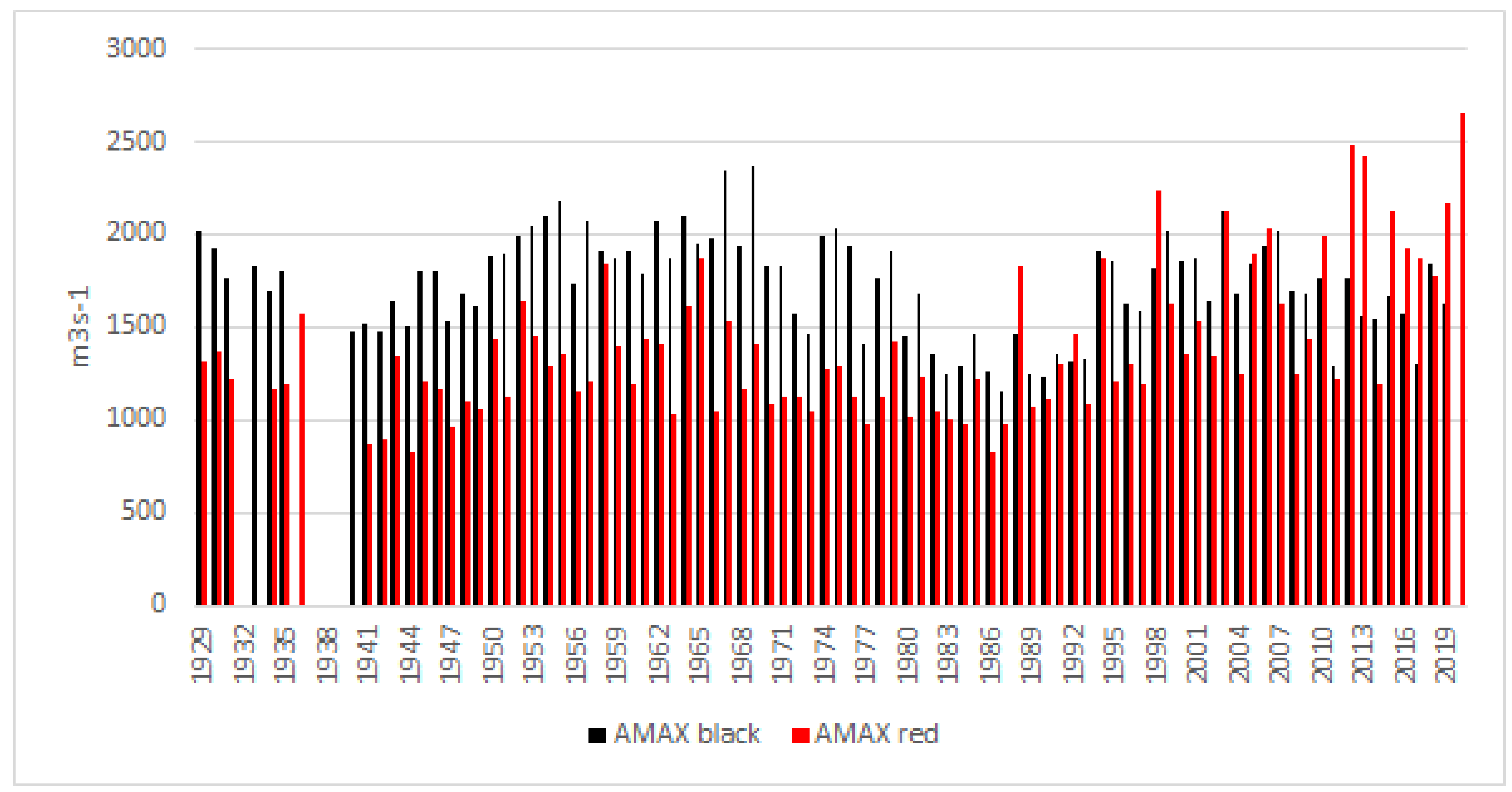
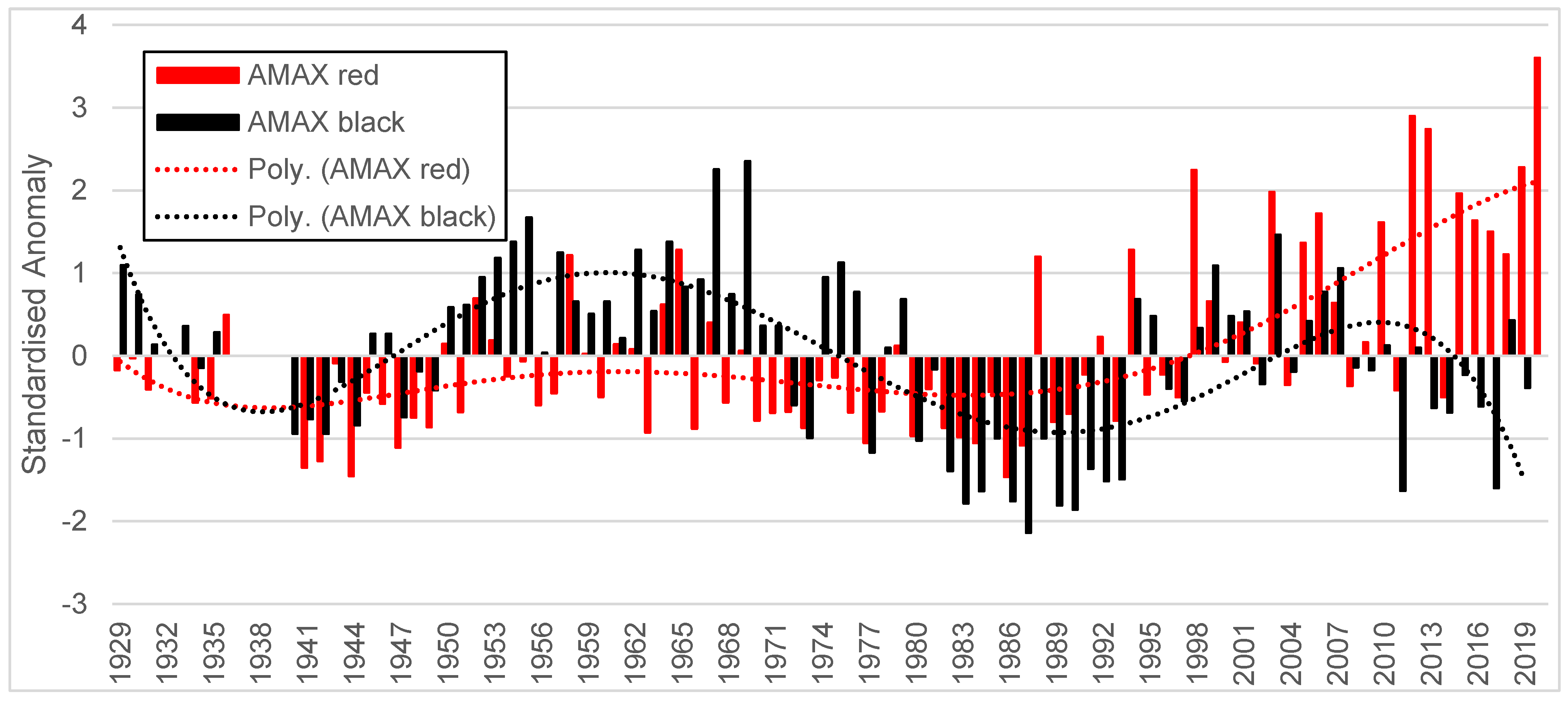
Figure 12.
Anomalies of red and black flood at Niamey gauging station (1929–2020) and 5th degree polynomial interpretation.
Figure 12.
Anomalies of red and black flood at Niamey gauging station (1929–2020) and 5th degree polynomial interpretation.
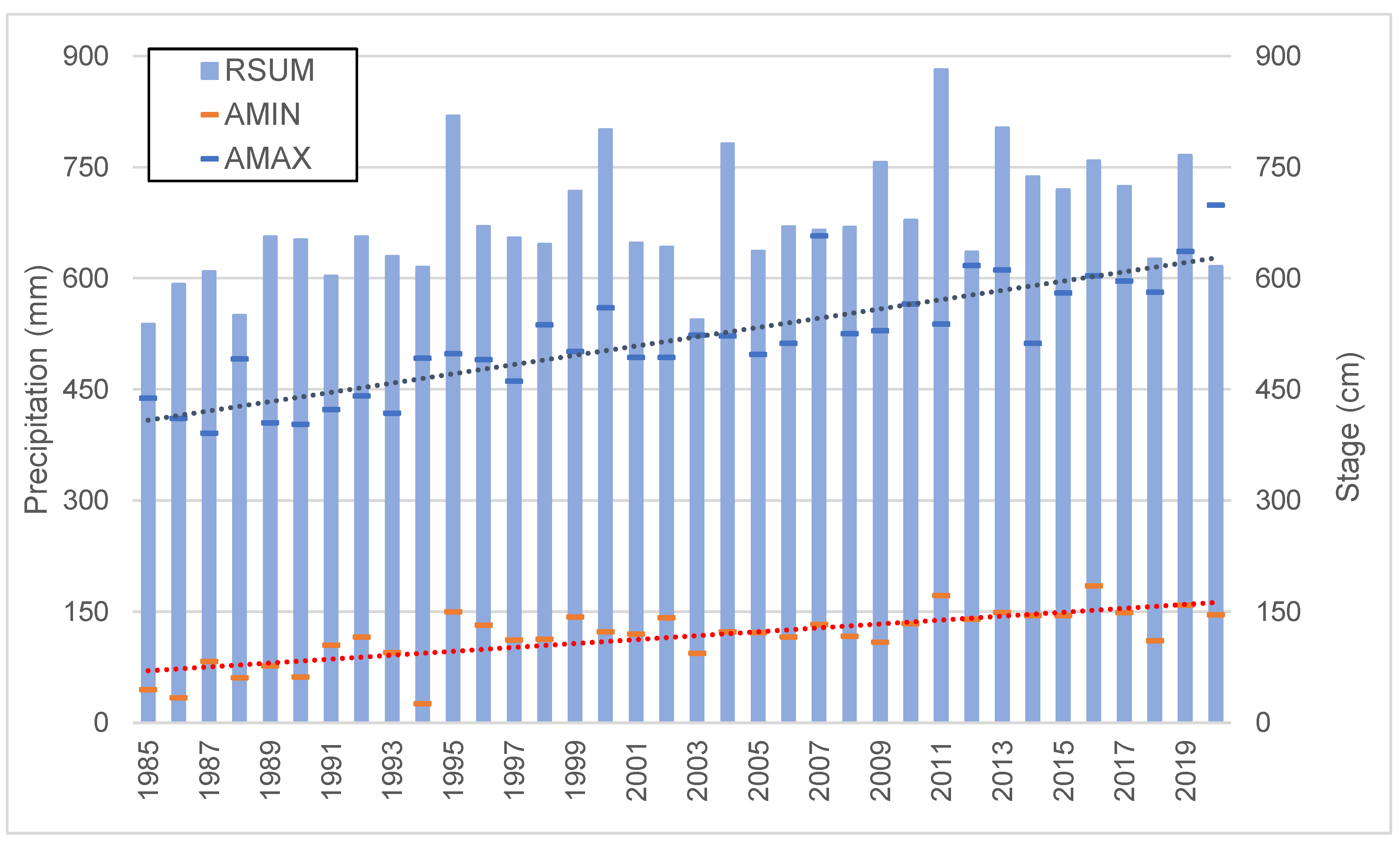
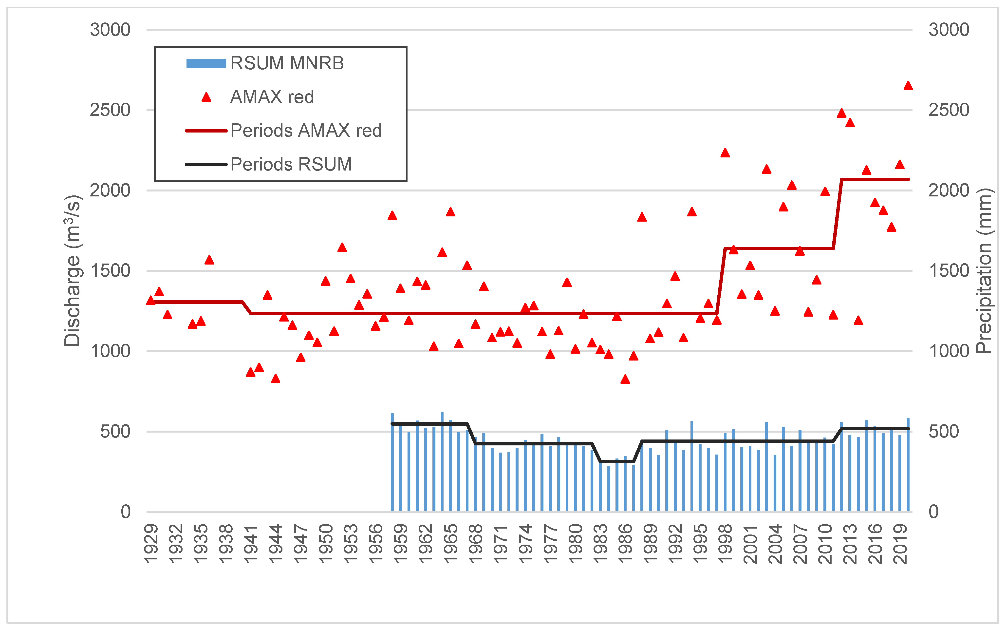
Figure 13.
Red AMAX in Niamey and annual precipitation (RSUM) over the MNRB with the average of the periods (Hubert segmentation with Sheffé 1%. Results of the different tests are provided in the
Supplementary materials).
Figure 13.
Red AMAX in Niamey and annual precipitation (RSUM) over the MNRB with the average of the periods (Hubert segmentation with Sheffé 1%. Results of the different tests are provided in the
Supplementary materials).
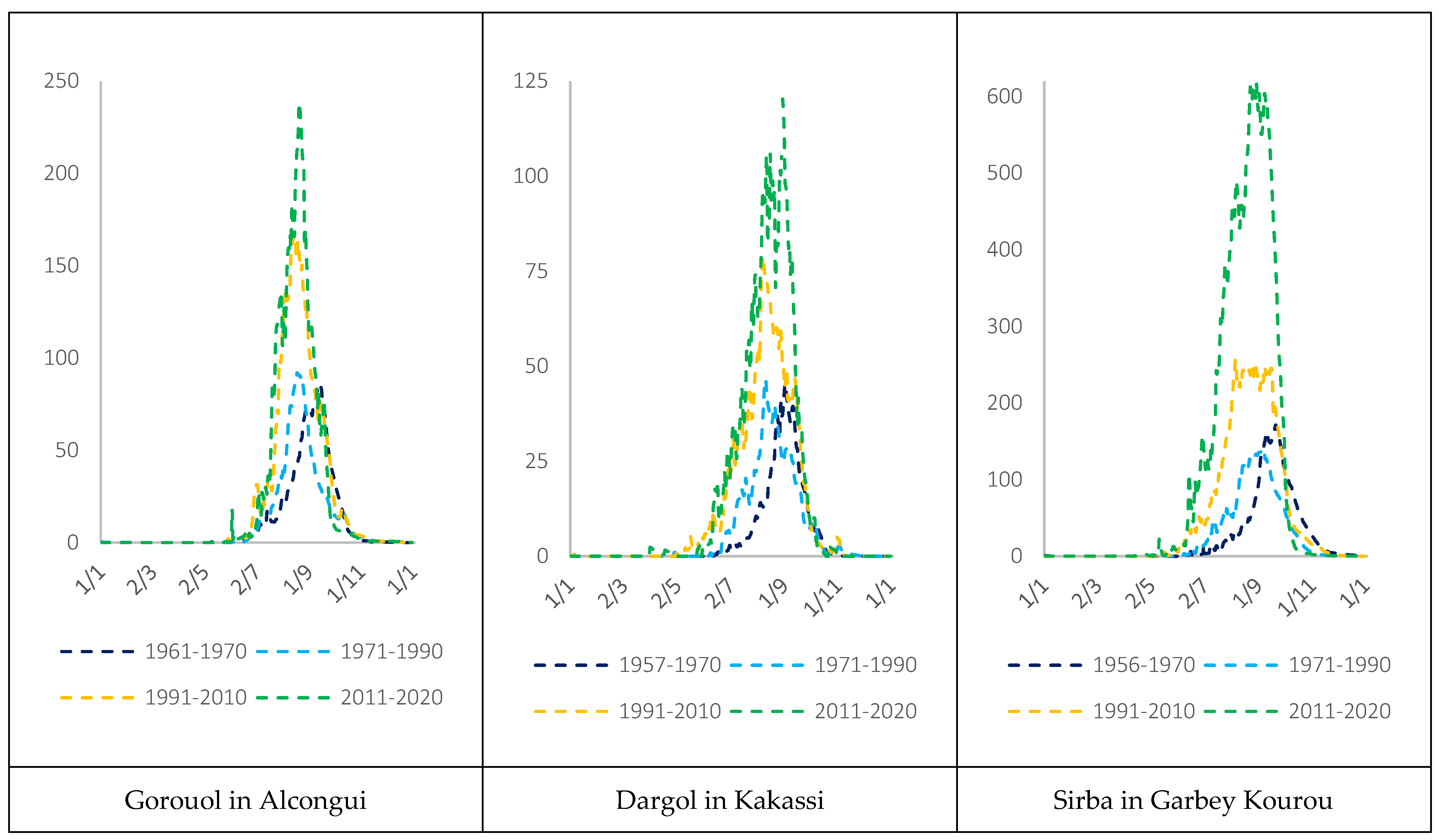
Figure 14.
Intra annual mean hydrographs (m3/s) of the main Sahelian basins (Gorouol, Dargol and Sirba rivers) in the four hydrological periods (I:19..–1970, II:1971–1990, III:1991–2010 and IV: 2011–2020).
Figure 14.
Intra annual mean hydrographs (m3/s) of the main Sahelian basins (Gorouol, Dargol and Sirba rivers) in the four hydrological periods (I:19..–1970, II:1971–1990, III:1991–2010 and IV: 2011–2020).
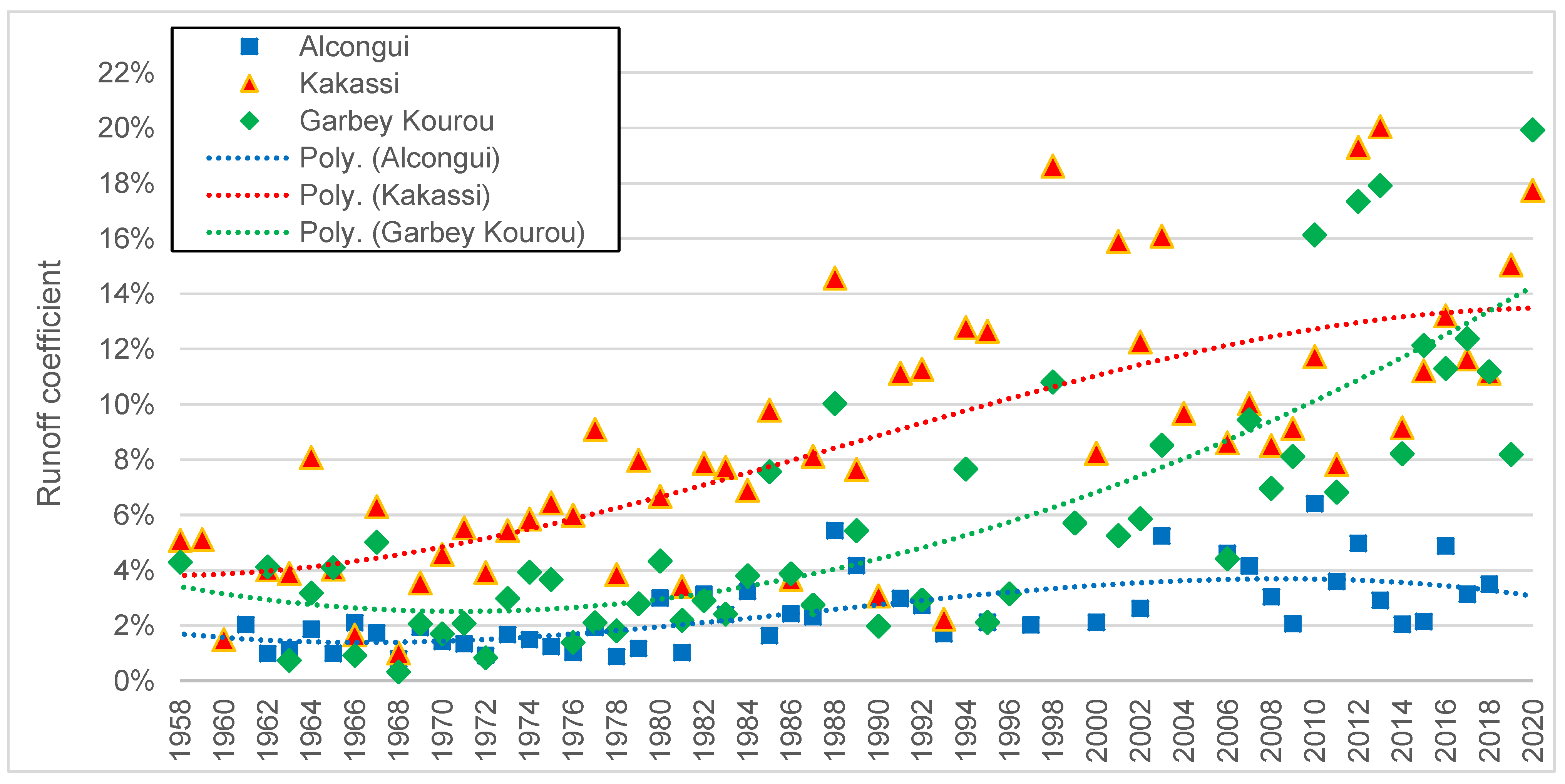
Figure 15.
Runoff coefficients over the period 1958–2020 of the three main Sahelian tributaries: Gorouol River at Alcongui, Dargol River at Kakassi and Sirba River at Garbey Kourou.
Figure 15.
Runoff coefficients over the period 1958–2020 of the three main Sahelian tributaries: Gorouol River at Alcongui, Dargol River at Kakassi and Sirba River at Garbey Kourou.
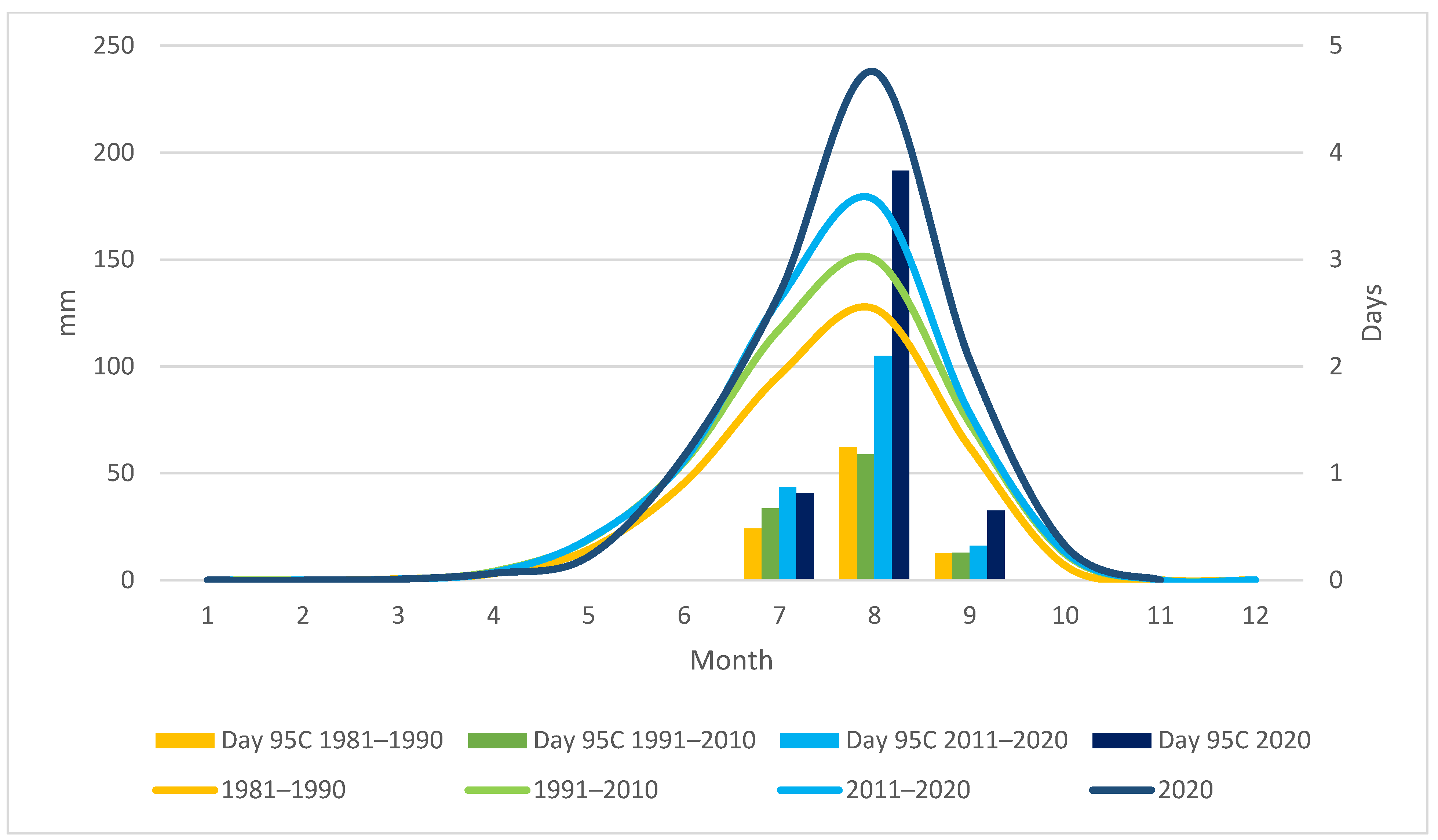
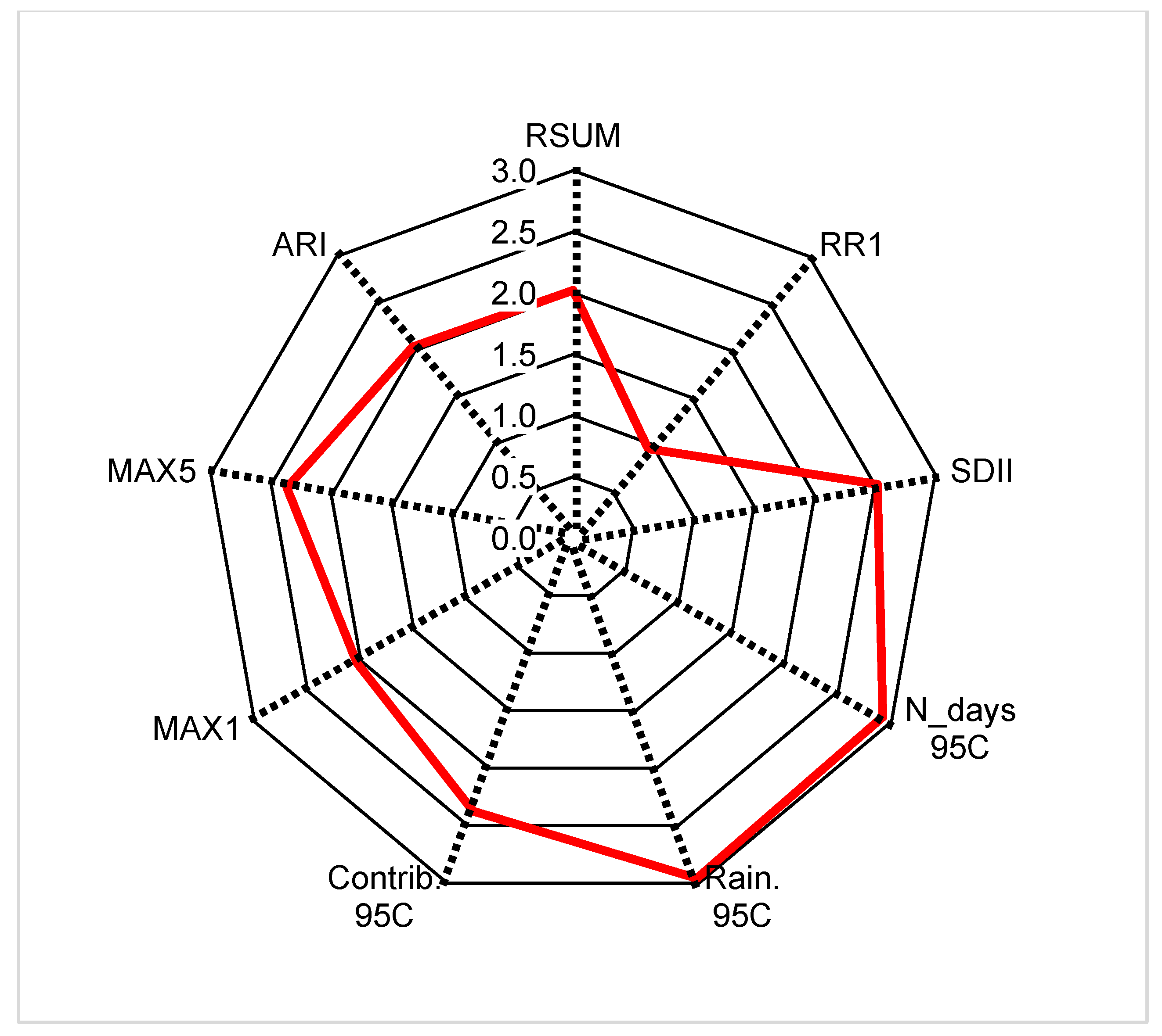
Figure 16.
Anomalies of rainfall indices in 2020 rainy season over MNRB (Normal = 0).
Figure 16.
Anomalies of rainfall indices in 2020 rainy season over MNRB (Normal = 0).
Figure 17.
Evolution of the Niger river main channel in Niamey between 2004 and 2020.
Figure 17.
Evolution of the Niger river main channel in Niamey between 2004 and 2020.
Figure 18.
Evolution of the alluvial fan of the ‘Palais de Congrès’ channel (between the bar and the bridge).
Figure 18.
Evolution of the alluvial fan of the ‘Palais de Congrès’ channel (between the bar and the bridge).
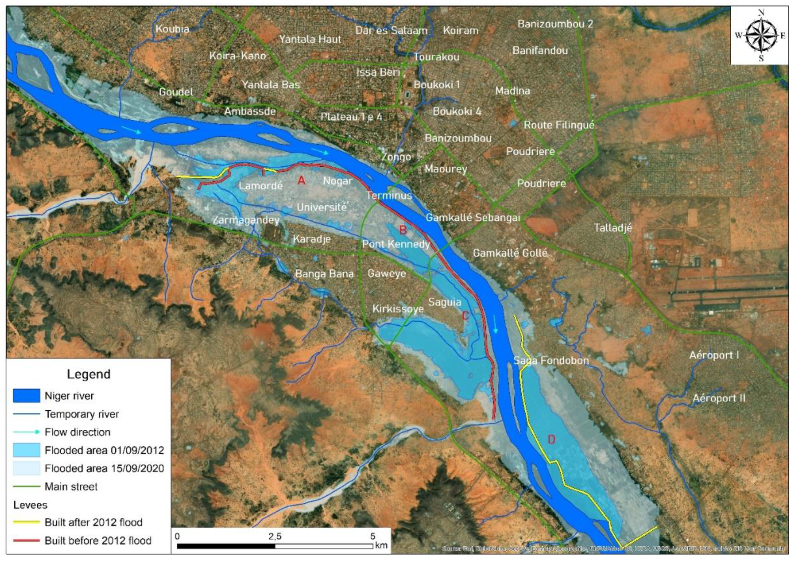
Figure 19.
Comparison of Niamey flooded areas in 2012 and 2020 events. The red letters identify the four levee sectors: (A) Lamordé, (B) bridges, (C) Kirkissoye-Saguia and (D) Saga.
Figure 19.
Comparison of Niamey flooded areas in 2012 and 2020 events. The red letters identify the four levee sectors: (A) Lamordé, (B) bridges, (C) Kirkissoye-Saguia and (D) Saga.
Table 1.
The glossary of acronyms used in the text (acronyms of climatic indices are exposed in Table 3).
Table 1.
The glossary of acronyms used in the text (acronyms of climatic indices are exposed in Table 3).
| Acronyms | Full Names |
|---|
| ADCP | Acoustic Doppler Current Profiler |
| AMAX | Annual Maximum of daily discharge |
| AMIN | Annual Minimum of daily discharge |
| CHIRPS | Climate Hazards Group Infrared Precipitation with Station data |
| DTM | Digital Terrain Model |
| FDC | Flow Duration Curves |
| GEV | Generalised Extreme Value |
| JAS | July-August-September |
| LULC | Land Use and Land Cover |
| MNRB | Medium Niger River Basin |
| NDFI | Normalised Difference Flooding Index |
| NID | Niger Inner Delta |
| NS | Non-Stationary |
| RC | Runoff Coefficient |
| RP | Return Period |
| TC | TerraClimate |
Table 2.
The main hydrometers used for flow monitoring on the MNRB. The basin area is computed at the hydrometric gauging station.
Table 2.
The main hydrometers used for flow monitoring on the MNRB. The basin area is computed at the hydrometric gauging station.
| Hydrometer | Rating Curve | River | Country | Basin (km2) | Installation Date | Complete Years | Completeness |
|---|
| Niamey | 2008 | Niger | Niger | 700,000 | 1929 | 86 | 94% |
| Kandaji | 1979 | Niger | Niger | 628,996 | 1975 | 41 | 89% |
| Alcongui | 1998 | Gorouol | Niger | 52,933 | 1961 | 50 | 83% |
| Kakassi | 2000 | Dargol | Niger | 7152 | 1957 | 59 | 92% |
| Garbey Kourou | 2004 | Sirba | Niger | 39,095 | 1956 | 56 | 86% |
Table 3.
Extreme rainfall indices used in this study.
Table 3.
Extreme rainfall indices used in this study.
| ID (Zhang ID) | Indicator Name | Indicator Definitions | Units |
|---|
| RSUM (PRCPTOT) | Annual total wet-day precipitation | Annual total precipitation from days ≥1 mm | mm |
| RR1 | Annual count of wet days | Number of days with precipitation ≥1 mm | days |
| SDII | Simple daily intensity index | The ratio of annual total precipitation to the number of wet days (≥1 mm) | mm/day |
| N_days_95P | Annual count of very wet days | Annual number of days with precipitation >95th percentile | day |
| N_days_95C July | July count of very wet days | July number of days with precipitation >95th percentile | day |
| N_days_95C August | August count of very wet days | August number of days with precipitation >95th percentile | day |
| N_days_95C Sept. | September count of very wet days | September number of days with precipitation >95th percentile | day |
| Rainfall 95P (R95p) | Very wet days | Annual total precipitation from days >95th percentile | mm |
| Contribution 95P | Contribution very wet days | The ratio of Annual total precipitation from days >95th percentile to the number of days with precipitation >95th percentile | % |
| RMAX1 (RX1day) | Max 1-day precipitation amount | Annual maximum 1-day precipitation | mm |
| RMAX5 (RX5day) | Max 5-day precipitation amount | Annual maximum consecutive 5-day precipitation | mm |
| ARI | Standardised Annual rainfall index | ARI = (Ry1 − Rav)/σs
where Ry1 is the annual rainfall, Rav is the mean annual rainfall on the data series and σs is the standard deviation in the reference period [53]. | Dimension-less |
Table 4.
Coefficient and application range of the rating curve equation of Niamey hydrometer.
Table 4.
Coefficient and application range of the rating curve equation of Niamey hydrometer.
| Validity | H (m) | h0 (m) | a | b | R2 |
|---|
| 1 June 2016–now | [0.9–7] | 0.9 | 89.891 | 1.873 | 0.992 |
Table 5.
Flood hazard thresholds (depth and flows) for the Niamey city and related return periods for red and black floods (*1 Rating curve 2008, *2 Rating curve 2016, *3 Q < Q365, *4 over the period 2011–2020, *5 Q < Q1, *6 for year 2020, *7 infinite).
Table 5.
Flood hazard thresholds (depth and flows) for the Niamey city and related return periods for red and black floods (*1 Rating curve 2008, *2 Rating curve 2016, *3 Q < Q365, *4 over the period 2011–2020, *5 Q < Q1, *6 for year 2020, *7 infinite).
| Colour | Importance | hMAX (cm) | QMAX (m3/s) | FDC *4 (Days in a Year) | Return Period (Years) | NS RP (Year) *6 |
|---|
| Old *1 | New *2 | Red Flood | Black Flood | Red Flood | Black Flood |
|---|
| grey | Low flow | 140 | 47 | 25 | *3 | / | / | / | / |
| green | Normal condition | 530 | 1700 | 1443 | 80 | 2.7 | 1.2 | 1 | 1 |
| yellow | Frequent flood | 580 | 2127 | 1766 | 20 | 6.5 | 2 | 1.2 | 10 |
| orange | Severe flood | 620 | 2512 | 2045 | 2 | 15 | 7 | 2 | 28,000 |
| TOP | Top levees | 660 | 2937 | 2344 |
*5 | 39 | 34 | 4.2 |
*7 |
| red | Catastrophic flood | 750 | 4055 | 3084 |
*5 | 425 | 4700 | 25 |
*7 |
Table 6.
Riverine floods events and related return periods of red AMAX causing damages in Niamey in the past decades. Source of affected people: 1998–2020 BDNIA [
30].
Table 6.
Riverine floods events and related return periods of red AMAX causing damages in Niamey in the past decades. Source of affected people: 1998–2020 BDNIA [
30].
| Flood | Date | Affected People (Thousands) | h (cm) | Q (m3/s) | RPRED (Year) | NS-RPRED (Year) |
|---|
| 1998 | 19 September | 27 | 537 | 2234 | 28 | 18 |
| 2010 | 7 September | 18 | 565 | 1993 | 13 | 3 |
| 2012 | 22 August | 45 | 617 | 2482 | 61 | 7.4 |
| 2013 | 30 August | 65 | 611 | 2422 | 50 | 6 |
| 2019 | 1 September | 6 | 636 | 2162 | 22 | 2.4 |
| 2020 | 8 September | 84 | 699 | 2653 | 106 | 5.5 |
Table 7.
Data series segmentation (fixed periods): mean, median and difference of annual precipitation over MNRB (RSUM); mean, median of red AMAX in Niamey. For normally distributed variables, the t-student test (t-test) was used. For non-normal distributed variables, the Wilcoxon–Mann–Whitney test (U-test) was used. The Δ-1 period is the difference (%) between the period and the previous ones. Significance of changes: *** p < 0.01, ** p < 0.05, * p < 0.1.
| Variable | Index | I: 19..–1970 | II: 1971–1990 | III: 1991–2010 | IV: 2011–2020 |
|---|
| RSUM | mean (mm) | 524 | 389 | 448 | 508 |
| median (mm) | 521 | 398 | 440 | 501 |
| t-test Δ-1 period | | −26% *** | +15% *** | +11% ** |
| Niamey red AMAX | mean (m3/s) | 1277 | 1142 | 1557 | 1984 |
| median (mm) | 1212 | 1118 | 1455 | 2025 |
| U test-1 period | | > ** | < *** | < ** |
Table 8.
Data series segmentation (fixed periods): Quantile regression of red AMAX in Niamey. Difference in medians among periods and standard errors (in parentheses). Significance of changes: *** p < 0.01, ** p < 0.05, * p < 0.1.
Table 8.
Data series segmentation (fixed periods): Quantile regression of red AMAX in Niamey. Difference in medians among periods and standard errors (in parentheses). Significance of changes: *** p < 0.01, ** p < 0.05, * p < 0.1.
| Niamey red AMAX | I: 1941–1970 | II: 1971–1990 | III: 1991–2010 | IV: 2011–2020 |
|---|
| I: 1941–1970 | - | 93.510 | −254.040** | −710.390 *** |
| | | (125.477) | (125.477) | (158.718) |
| II: 1971–1990 | −93.510 | - | −347.550 ** | −803.900 *** |
| | (125.477) | | (137.454) | (168.346) |
| III: 1991–2010 | 254.040 ** | 347.550 ** | - | −456.350 *** |
| | (125.477) | (137.454) | | (168.346) |
| IV: 2011–2020 | 710.390 *** | 803.900 *** | 456.350 *** | - |
| | (158.718) | (168.346) | (168.346) | |
| Constant (median) | 1213.510 *** | 1120.000 *** | 1467.550 *** | 1923.900 *** |
| | (79.359) | (97.194) | (97.194) | (137.454) |
Table 9.
Data series segmentation (fixed periods): mean, median and difference of AMAX of the main Sahelian tributaries. For non-normal distributed variables, the Wilcoxon–Mann–Whitney test (U-test) and the quantile regression (Qreg) were used. The Δ-1 period is the difference (%) between the period and the previous ones. Significance of changes: *** p < 0.01, ** p < 0.05, * p < 0.1. (#the flow time series of Gorouol stops in 2018).
| Basin | Index | I: 19..−1970 | II: 1971−1990 | III: 1991−2010 | IV: 2011−2020 |
|---|
| Sirba AMAX | mean (m3/s) | 225 | 225 | 431 | 863 |
| mean (l/km2) | 5.76 | 5.76 | 11.02 | 22.07 |
| median (m3/s) | 194 | 166 | 409 | 866 |
| U test-1 period | | | < *** | < *** |
| Qreg Δ-1 period | | −14% | 147% *** | 111% ** |
| Dargol AMAX | mean (m3/s) | 73 | 70 | 134 | 218 |
| mean (l/km2) | 10.21 | 9.79 | 18.74 | 30.48 |
| median (m3/s) | 57 | 65 | 128 | 269 |
| U test-1 period | | | < *** | < ** |
| Qreg Δ-1 period | | 13% | 98% *** | 110% *** |
| Gorouol AMAX | mean (m3/s) | 125 | 143 | 244 | 304# |
| mean (l/km2) | 2.36 | 2.70 | 4.60 | 5.74# |
| median (m3/s) | 93 | 121 | 192 | 237# |
| U test-1 period | | | < *** | |
| Qreg Δ-1 period | | 30% | 59% | 24%# |
Table 10.
Data series segmentation (fixed periods): mean, median and difference of RC of the main Sahelian tributaries. For non-normal distributed variables, the Wilcoxon–Mann–Whitney test (U-test) and the quantile regression (Qreg) were used. The Δ-1 period is the difference (%) between the period and the previous ones. Significance of changes: *** p < 0.01, ** p < 0.05, * p < 0.1. (#the flow time series of Gorouol stops in 2018).
| Basin | Index | I: 19..–1970 | II: 1971–1990 | III: 1991–2010 | IV: 2011–2020 |
|---|
| Sirba RC | mean (%) | 2.6 | 3.4 | 6.9 | 12.5 |
| median (%) | 3.2 | 2.9 | 7 | 12.2 |
| U test-1 period | | | < *** | < *** |
| Qreg Δ-1 period | | −9% | 141% *** | 74% ** |
| Dargol RC | mean (%) | 4.1 | 6.7 | 11.2 | 13.6 |
| median (%) | 4 | 6.7 | 11.1 | 13.2 |
| U test-1 period | | < ** | < *** | |
| Qreg Δ-1 period | | +65% ** | +67% *** | +19% |
| Gorouol RC | mean (%) | 1.5 | 2.1 | 3.2 | 3.4# |
| median (%) | 1.4 | 1.7 | 2.7 | 3.5# |
| U test-1 period | | | < ** | |
| Qreg Δ-1 period | | +14% * | +65% ** | +30%# |
Table 11.
Data series segmentation (fixed periods): mean and difference of rainfall indexes over MNRB. For normally distributed variables the t-Student test (t-test) is showed while for non-normal distributed variables, the Wilcoxon–Mann–Whitney test (U-test) is showed. Significance of changes: *** p < 0.01, ** p < 0.05, * p < 0.1.
| Rainfall Index | Unit | II 1981–1990 | III 1991–2010 | IV 2011–2020 |
| RSUM | mean (mm) | 355.69 | 432.21 | 480.26 |
| t-test Δ−1 period | | 22% *** | 11% ** |
| RR1 | mean (days) | 43.67 | 51.08 | 53.40 |
| t-test Δ−1 period | | 17% *** | 5% |
| SDII | mean (mm/day) | 7.95 | 8.28 | 8.83 |
| t-test Δ−1 period | | 4% | 7% * |
| N_days_95C | mean (days) | 2.18 | 2.22 | 3.35 |
| t-test Δ−1 period | | 2% | 51% *** |
| N_days_95C_08 | mean (days) | 1.24 | 1.18 | 2.10 |
| t-test Δ−1 period | | −5% | 78% *** |
| Rain_95C | mean (mm) | 63.97 | 59.78 | 91.88 |
| U test −1 period | | | < *** |
| Contrib_95C | mean (%) | 0.17 | 0.13 | 0.18 |
| U test −1 period | | | < *** |
| MAX1 | mean (mm) | 29.94 | 28.06 | 31.13 |
| t-test Δ−1 period | | −6% | 11% ** |
| MAX5 | mean (mm) | 52.76 | 53.76 | 61.91 |
| t-test Δ−1 period | | 2% | 15% *** |
Table 12.
Correlation matrix between red AMAX and rainfall indexes over MNRB. Pearson correlation coefficients and their significance level: *** p < 0.01, ** p < 0.05, * p < 0.1.
Table 12.
Correlation matrix between red AMAX and rainfall indexes over MNRB. Pearson correlation coefficients and their significance level: *** p < 0.01, ** p < 0.05, * p < 0.1.
| | 1981–2020 | II 1981–1990 | III 1991–2010 | IV 2011–2020 |
|---|
| AMAX | AMAX | AMAX | AMAX |
|---|
| RSUM | 0.8296 *** | 0.7037 ** | 0.7796 *** | 0.7122 ** |
| RR1 | 0.7506 *** | 0.6036 * | 0.7064 *** | 0.6051 * |
| SDII | 0.6372 *** | 0.5423 | 0.5148 ** | 0.4771 |
| N_days_95C | 0.7058 *** | 0.648 ** | 0.6138 *** | 0.7832 *** |
| Contrib_95C | 0.4 ** | 0.4943 | 0.4092 * | 0.7279 ** |
| Rain_95C | 0.6392 *** | 0.5993 * | 0.5884 *** | 0.7666 *** |
| MAX1 | 0.3298 ** | 0.4264 | 0.3855 * | 0.4974 |
| MAX5 | 0.6427 *** | 0.6776 ** | 0.6052 *** | 0.5595 * |
Table 13.
Anomalies of red AMAX and extreme rainfall indexes for years with red AMAX anomaly >1 st.dev (sorted by Red AMAX).
Table 13.
Anomalies of red AMAX and extreme rainfall indexes for years with red AMAX anomaly >1 st.dev (sorted by Red AMAX).
| Year | Red AMAX | RSUM | SDII | N_Days_95C | N_Days_95C July | N_Days_95C August | N_Days_95C Sept. | MAX1 | MAX5 | ARI |
|---|
| 2020 | 2.33 | 2.02 | 2.52 | 2.92 | 0.38 | 3.06 | 1.48 | 2.04 | 2.37 | 2.04 |
| 2012 | 1.96 | 1.74 | 1.59 | 1.70 | −0.04 | 1.68 | 1.88 | 0.73 | 1.82 | 1.80 |
| 2013 | 1.84 | 0.27 | −0.67 | 0.26 | −0.76 | 1.08 | −0.91 | −0.11 | 0.23 | 0.30 |
| 1998 | 1.44 | 1.17 | 1.04 | 1.15 | 1.48 | −0.44 | 3.41 | 0.62 | 0.23 | 1.15 |
| 2019 | 1.29 | 0.57 | 0.00 | 0.91 | −0.46 | 1.85 | −1.04 | 0.78 | 1.03 | 0.53 |
| 2003 | 1.23 | 1.49 | 0.72 | 0.57 | 1.00 | −0.16 | 0.79 | 0.03 | 0.10 | 1.35 |
| 2015 | 1.21 | 1.05 | 1.13 | 1.15 | 3.66 | −0.19 | −0.66 | 0.17 | 0.70 | 1.02 |
