User Needs Analysis for the Definition of Operational Coastal Services


Abstract
1. Introduction
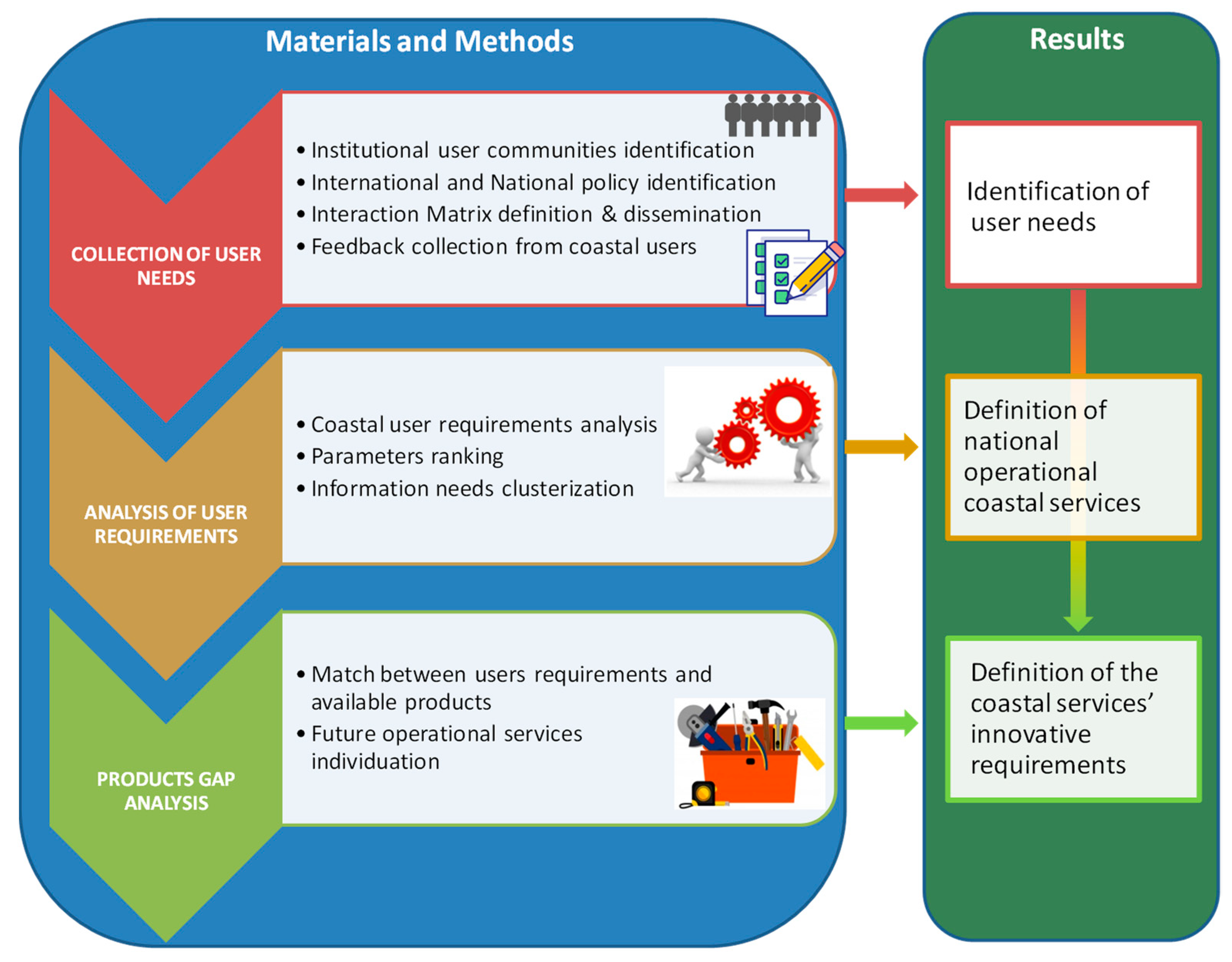
2. Materials and Methods
- identification of the institutional users to be interviewed;
- organization of the questionnaire to be submitted to the institutional users selected in the previous phase;
- collection and homogenization of the survey answers, grouping them by type of user and their institutional duties, based on regulations;
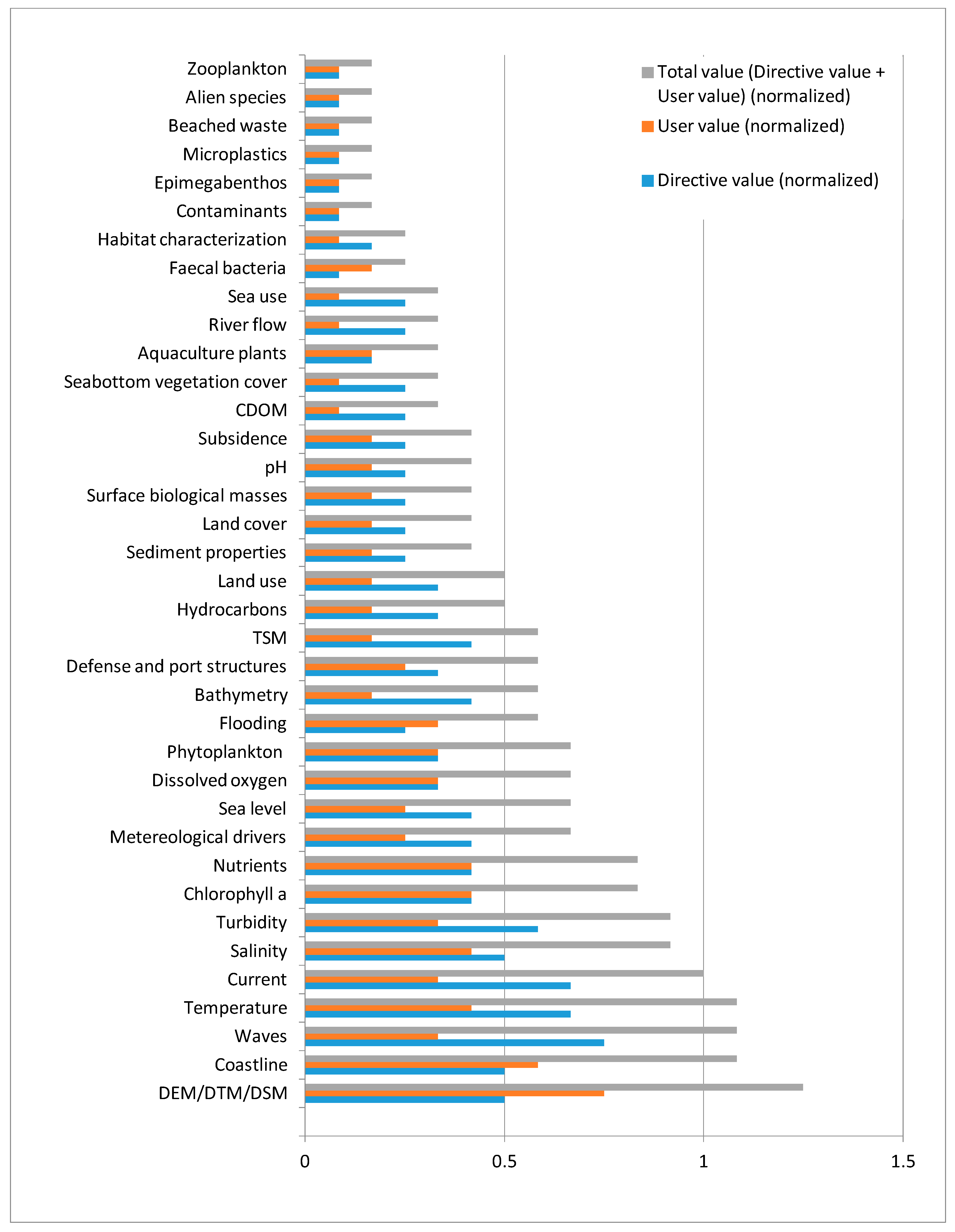
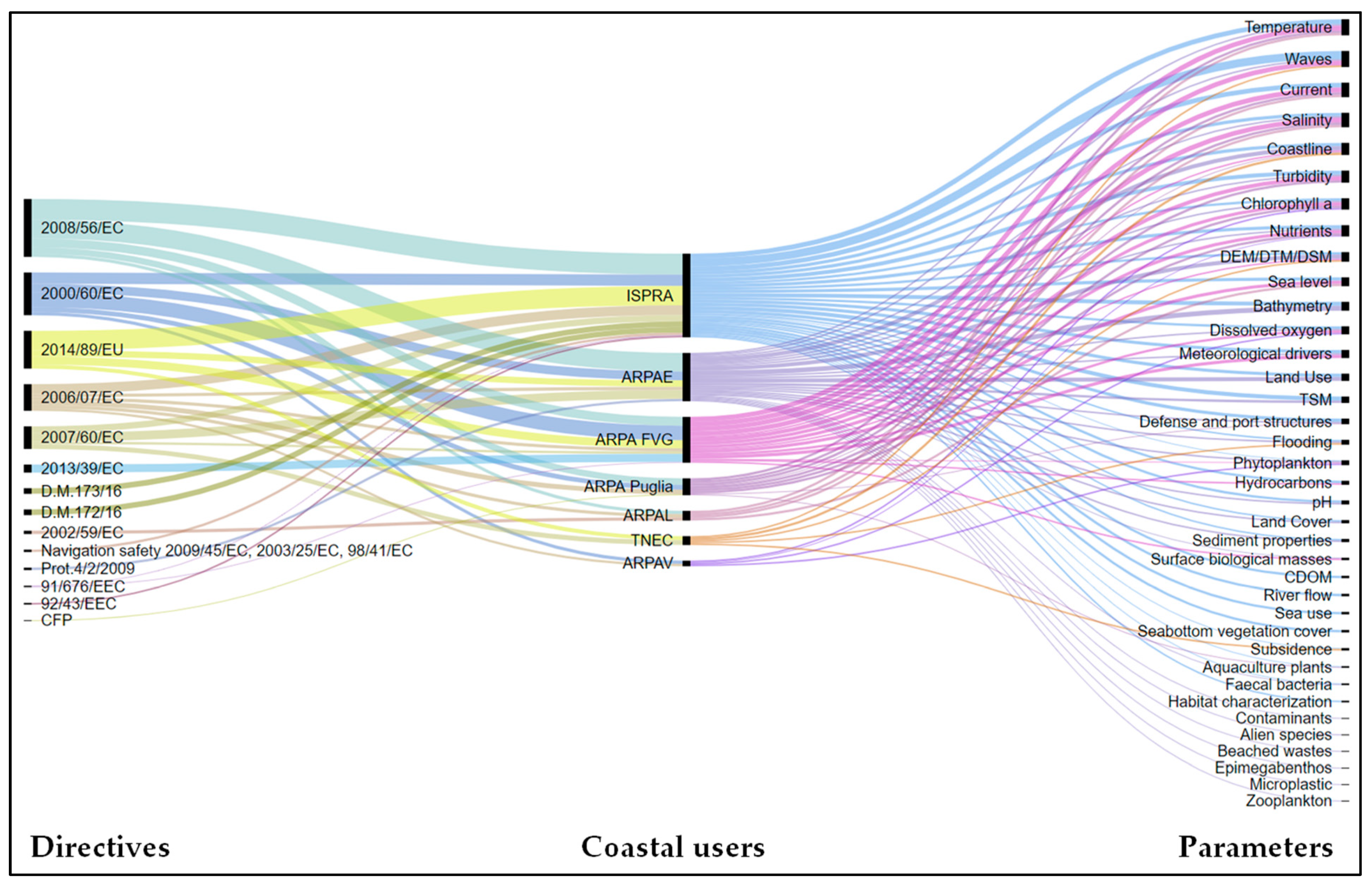
- analysis of the gathered users’ requirements on the basis of regulations and requested parameters typology;
- prioritization of parameters based on the number of users and reference regulations;
- definition of the operational services to be implemented at national level, considering the gap between the needs and the available products (Copernicus services products and others).
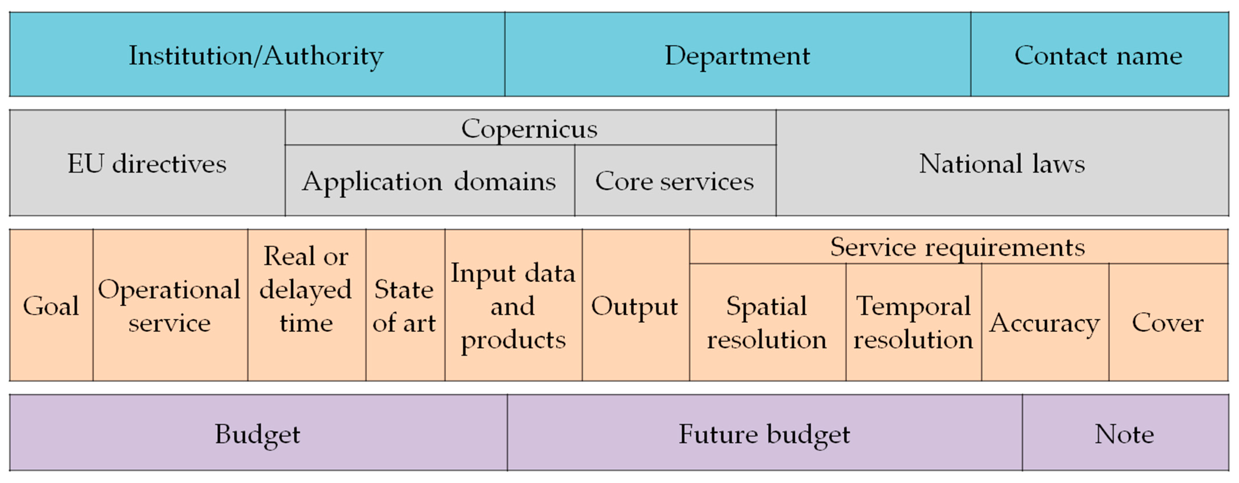
2.1. Collection of User Needs
- information about the user who answered the questionnaire, such as the name of the Institution or Authority, the specific department, and the individual contacts;
- recognition of the European Directive, the relevant Copernicus core service and application domain and the legislative implementation at national level;
- definition of the required operational service by identifying the objective of the service, the need for provision in real or deferred time, the input data and the output to be obtained, with an indication of the relative spatial and temporal resolution, accuracy and coverage of the requested service. It should be noted that these requirements refer to the functional characteristics of the requested services and to the information to be acquired (not earth observation expert based) and do not represent the technical requirements that must be identified in a second phase by EO experts;
- information on the financial investments used at present for the provision of the specific service and possible cost estimation for its innovation.
2.2. Analysis of User Requirements
- biogeochemical;
- physical;
- geomorphologic;
- hydrometeorological;
- transport of pollutants;
- land cover;
- land use.
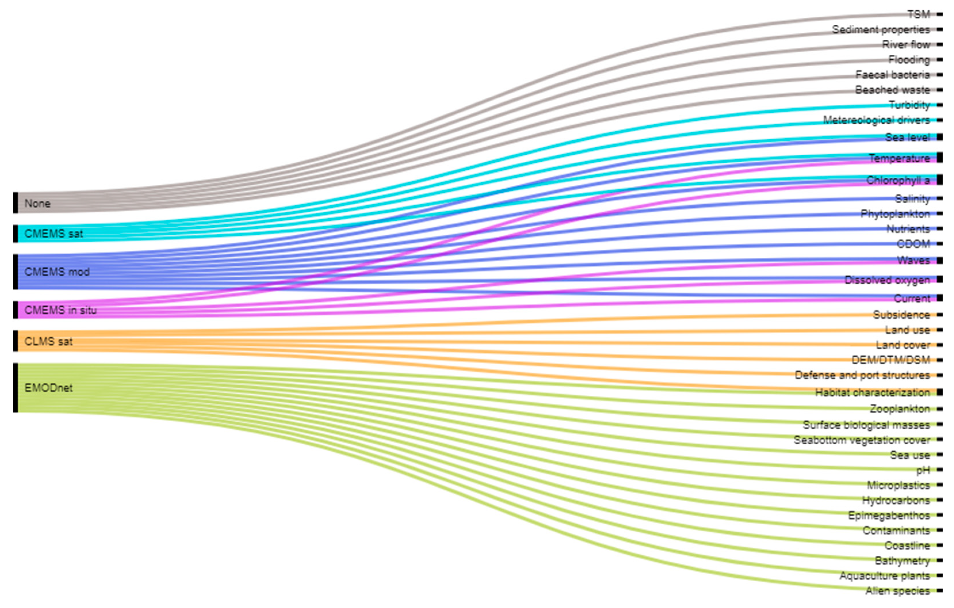
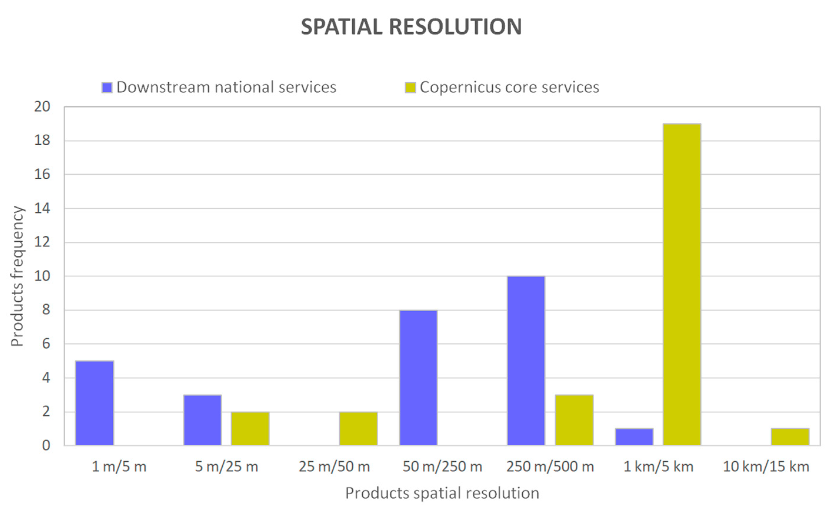
2.3. Products Gap Analysis
- start from the European and national regulations (optimizing the monitoring of the parameters required by users in compliance with the different laws);
- systemize common parts to multiple services;
- consider the integration of remote, in-situ and modeled data and products;
- insert only consolidated products in terms of reliability of results and ready for pre-operation or operation applications;
- define the processing level of the products delivered by each service: “level 1” for services that not depend from others, instead “level 2” for services that have in input one or more products coming from “level 1” services, for example for peculiar needs;
- specify if the services are based on space data processing or on models application;
- indicate the required products delivering way for each service: “real time” or “deferred time”, “regular” or “on demand”;
- give priority to data validation and accuracy, fundamental for institutional responsible use to make decisions.
3. Results
3.1. Identification of User Needs
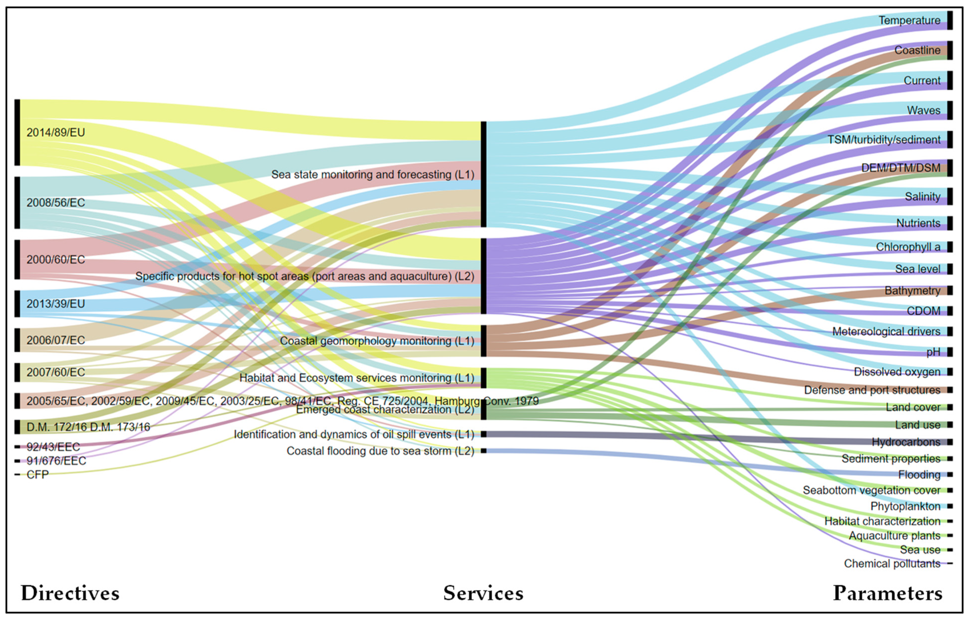
3.2. Definition of National Operational Coastal Services
- sea monitoring and forecasting (Level 1);
- coastal geomorphology monitoring (Level 1);
- emerged coast characterization (Level 2);
- habitat and Ecosystem services monitoring (Level 1);
- specific products for hot spot areas (port areas and aquaculture) (Level 2);
- identification and dynamics of oil spill events (Level 1);
- coastal flooding due to sea storm (Level 2).
3.3. Definition of the Coastal Services’ Innovative Requirements
4. Discussion
- at the European level, of the products that must be provided by Core Copernicus services as input to national downstream processes, ensuring coordination between the various Copernicus components and the RoadMap for the evolution of Core Marine and Land services aimed to the identification of the products of interface between base core services and specific downstream systems tailored on member states users’ demand;
- at EU Member States level, of the harmonization procedure of user requirements analysis and operational coastal services definition to be implemented intra-State and inter-States, encouraging the use, reuse and accessibility of information and harmonizing products between the different Countries to favor the acquisition of a complete and homogeneous picture of coastal areas and trans-national effects for government management.
5. Conclusions
- systematic and integrated, since the same procedure has been used to define all the thematic operational services developed in the space economy context, creating a system of integrated and interconnected modules.
- qualified, since the demand comes from institutional users who has to carry out their own tasks linked to the international and national legislation, so representing the anchor customer for the institutional and commercial services’ industry market.
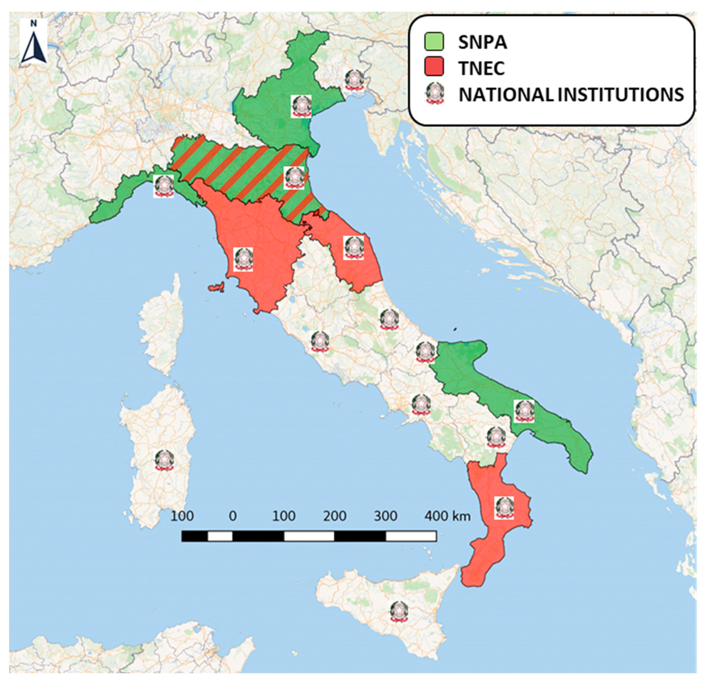
- representative and homogeneous, since the interviewed coastal users are geographically distributed and cover all the different thematic issues, providing a complete overview of the national needs for coastal operational services.
Supplementary Materials
Author Contributions
Funding
Data Availability Statement
Conflicts of Interest
References
- European Commission. Directorate General for Maritime Affairs and Fisheries and the Joint Research Centre. The EU Blue Economy Report 2019. Publ. Off. Eur. Union 2019. [Google Scholar] [CrossRef]
- United Nations Convention on the Law of the Sea. Available online: https://www.un.org/Depts/los/convention_agreements/texts/unclos/unclos_e.pdf (accessed on 9 June 2020).
- EUR-Lex: Integrated Coastal Zone Management—ICZM. Available online: https://eur-lex.europa.eu/legal-content/EN/TXT/?uri=CELEX%3A32002H0413 (accessed on 12 April 2020).
- EUR-Lex: Water Framework Directive—2000/60/EC. Available online: https://eur-lex.europa.eu/legal-content/EN/TXT/?uri=celex:32000L0060 (accessed on 13 April 2020).
- EUR-Lex: Marine Strategy Framework Directive—2008/56/EC. Available online: https://eur-lex.europa.eu/legal-content/EN/TXT/?uri=CELEX%3A32008L0056 (accessed on 13 April 2020).
- EUR-Lex: Urban Waste Water Treatment Directive—91/271/EEC. Available online: https://eur-lex.europa.eu/legal-content/EN/TXT/?uri=CELEX%3A31991L0271 (accessed on 10 June 2020).
- EUR-Lex: Nitrates Directive—91/676/EC. Available online: https://eur-lex.europa.eu/legal-content/EN/TXT/?uri=celex%3A31991L0676 (accessed on 10 June 2020).
- EUR-Lex: Integrated Pollution Prevention and Control—2010/75/EU. Available online: https://eur-lex.europa.eu/legal-content/EN/TXT/?uri=CELEX%3A32010L0075 (accessed on 10 June 2020).
- EUR-Lex: Priority Substance in the Field of Water Policy Directive—2013/39/EU. Available online: https://eur-lex.europa.eu/legal-content/EN/ALL/?uri=CELEX%3A32013L0039 (accessed on 15 June 2020).
- EUR-Lex: Habitats Directive—92/43/EEC. Available online: https://eur-lex.europa.eu/legal-content/EN/TXT/?uri=celex%3A31992L0043 (accessed on 8 June 2020).
- EUR-Lex: Birds Directive—2009/147/EC. Available online: https://eur-lex.europa.eu/legal-content/EN/TXT/?uri=CELEX%3A32009L0147 (accessed on 9 June 2020).
- EUR-Lex: Bathing Waters Directive—2006/7/EC. Available online: https://eur-lex.europa.eu/legal-content/EN/TXT/?uri=celex%3A32006L0007 (accessed on 23 July 2020).
- EUR-Lex: Floods Directive—2007/60/EC. Available online: https://eur-lex.europa.eu/legal-content/EN/TXT/?uri=CELEX%3A32007L0060 (accessed on 23 July 2020).
- EUR-Lex: Directive on Safety Rules and Standards for Passenger Ships 2009/45/EC. Available online: https://eur-lex.europa.eu/legal-content/en/TXT/?uri=CELEX:32009L0045 (accessed on 23 July 2020).
- EUR-Lex: Directive on Specific Stability Requirements for ro-ro Passenger Ships—2003/25/EC. Available online: https://eur-lex.europa.eu/legal-content/GA/TXT/?uri=CELEX:32003L0025 (accessed on 23 July 2020).
- EUR-Lex: Directive on the Registration of Persons Sailing on Board Passenger Ships Operating to or from Ports of the Member States of the Community—98/41/EC. Available online: https://eur-lex.europa.eu/legal-content/EN/TXT/?uri=CELEX%3A31998L0041 (accessed on 23 July 2020).
- EUR-Lex: Maritime Spatial Planning Directive—2014/89/EU. Available online: https://eur-lex.europa.eu/legal-content/EN/TXT/?uri=celex%3A32014L0089 (accessed on 5 May 2020).
- European Commission: Common Fisheries Policy—CFP. Available online: https://ec.europa.eu/fisheries/cfp_en (accessed on 23 July 2020).
- EUR-Lex: Regulation (EU) No 377/2014 of the European Parliament and of the Council of 3 April 2014 establishing the Copernicus Programme and repealing Regulation (EU) No 911/2010. Available online: https://eur-lex.europa.eu/legal-content/EN/TXT/?uri=CELEX%3A32014R0377 (accessed on 11 March 2020).
- Copernicus. Available online: https://www.copernicus.eu/en (accessed on 11 March 2020).
- Group of Earth Observations (GEO). Available online: http://www.earthobservations.org/index.php (accessed on 20 July 2020).
- Verstraete, M.M.; Diner, D.J.; Bézy, J.L. Planning for a spaceborne Earth Observation mission: From user expectations to measurement requirements. Environ. Sci. Policy 2015, 54, 419–427. [Google Scholar] [CrossRef]
- Politi, E.; Paterson, S.K.; Scarrott, R.; Tuohy, E.; O’Mahony, C.; Cámaro-García, W.C.A. Earth observation applications for coastal sustainability: Potential and challenges for implementation. Anthr. Coasts 2019, 2, 306–329. [Google Scholar] [CrossRef]
- European Commission: Communication from the Commission to the European Parliament, the Council, the European Economic and Social Committee and the Committee of the Regions, Space Strategy for Europe (COM 2016, 705). Available online: https://ec.europa.eu/transparency/regdoc/rep/1/2016/EN/COM-2016-705-F1-EN-MAIN.PDF (accessed on 5 April 2020).
- Small, C.; Steckler, M.; Seeber, L.; Akhter, S.H.; Goodbred, S., Jr.; Mia, B.; Imam, B. Spectroscopy of sediments in the Ganges–Brahmaputra delta: Spectral effects of moisture, grain size and lithology. Remote Sens. Environ. 2009, 113, 342–361. [Google Scholar] [CrossRef]
- Valentini, E.; Taramelli, A.; Filipponi, F.; Giulio, S. An effective procedure for EUNIS and Natura 2000 habitat type mapping in estuarine ecosystems integrating ecological knowledge and remote sensing analysis. Ocean Coast Manag. 2015, 108, 52–64. [Google Scholar] [CrossRef]
- Valentini, E.; Taramelli, A.; Cappucci, S.; Filipponi, F.; Nguyen Xuan, A. Exploring the Dunes: The Correlations between Vegetation Cover Pattern and Morphology for Sediment Retention Assessment Using Airborne Multisensor Acquisition. Remote Sens. 2020, 12, 1229. [Google Scholar] [CrossRef]
- Corbane, C.; Raclot, D.; Jacob, F.; Albergel, J.; Andrieux, P. Remote sensing of soil surface characteristics from a multiscale classification approach. Catena 2008, 75, 308–318. [Google Scholar] [CrossRef]
- Klemas, V. Remote sensing techniques for studying coastal ecosystems: An overview. J. Coast. Res. 2011, 27, 2–17. [Google Scholar] [CrossRef]
- Ban, Y.; Jacob, A.; Gamba, P. Spaceborne SAR data for global urban mapping at 30 m resolution using a robust urban extractor. ISPRS J. Photogramm. Remote Sens. 2015, 103, 28–37. [Google Scholar] [CrossRef]
- Joshi, N.; Baumann, M.; Ehammer, A.; Fensholt, R.; Grogan, K.; Hostert, P.; Jepsen, M.R.; Kuemmerle, T.; Meyfroidt, P.; Mitchard, E.T.A.; et al. A review of the application of optical and radar remote sensing data fusion to land use mapping and monitoring. Remote Sens. 2016, 8, 70. [Google Scholar] [CrossRef]
- Assennato, F.; D’Antona, M.; Di Leginio, M.; Strollo, A.; Munafò, M. Assessing land consumption impact on ecosystem services provision: An insight on biophysical and economic dimension of loss of erosion control in Italy. Authorea 2020. [Google Scholar] [CrossRef]
- Wu, W.; Yang, Z.; Tian, B.; Huang, Y.; Zhou, Y.; Zhang, T. Impacts of coastal reclamation on wetlands: Loss, resilience and sustainable management. Estuar. Coast. Shelf Sci. 2018, 210, 153–161. [Google Scholar] [CrossRef]
- Rojas, C.; Munizaga, J.; Rojas, O.; Martinez, C.; Pino, J. Urban development versus wetland loss in a coastal Latin American city: Lessons for sustainable land use planning. Land Use Policy 2019, 80, 47–56. [Google Scholar] [CrossRef]
- Gens, R. Remote sensing of coastlines: Detection, extraction and monitoring. Int. J. Remote Sens 2010, 31, 1819–1836. [Google Scholar] [CrossRef]
- Wang, X.; Liu, Y.; Ling, F.; Liu, Y.; Fang, F. Spatio-temporal change detection of Ningbo coastline using Landsat time-series images during 1976–2015. ISPRS Int. J. Geo-Inf. 2017, 6, 68. [Google Scholar] [CrossRef]
- Deepika, B.; Avinash, K.; Jayappa, K. Shoreline change rate estimation and its forecast: Remote sensing, geographical information system and statistics-based approach. Int. J. Environ. Sci. Technol. 2014, 11, 395–416. [Google Scholar] [CrossRef]
- Suo, A.; Zhang, M. Sea areas reclamation and coastline change monitoring by remote sensing in coastal zone of Liaoning in China. J. Coast. Res. 2015, 73, 725–729. [Google Scholar] [CrossRef]
- Ninfo, A.; Ciavola, P.; Billi, P. The Po Delta is restarting progradation: Geomorphological evolution based on a 47-years Earth Observation dataset. Sci. Rep. 2018, 8, 3457. [Google Scholar] [CrossRef]
- Winter, C. Macro scale morphodynamics of the German North Sea coast. J. Coast. Res. 2011, 64, 706–710. [Google Scholar]
- Allen, T.R.; Oertel, G.F.; Gares, P.A. Mapping coastal morphodynamics with geospatial techniques, Cape Henry, Virginia, USA. Geomorphology 2012, 137, 138–149. [Google Scholar] [CrossRef]
- Klemas, V. Remote sensing of emergent and submerged wetlands: An overview. Int. J. Remote Sens 2013, 34, 6286–6320. [Google Scholar] [CrossRef]
- Adam, E.; Mutanga, O.; Rugege, D. Multispectral and hyperspectral remote sensing for identification and mapping of wetland vegetation: A review. Wetl. Ecol. Manag. 2010, 18, 281–296. [Google Scholar] [CrossRef]
- Geraldini, S.; Valentini, E.; Xuan, A.N.; Bellotti, G.; Taramelli, A. Magnitudes, Spatial and Temporal Patterns of Self-Organized Processes Between Morphology and Biota that Lead Deltas Evolution. In Proceedings of the Poster in AGU Fall Meeting, Washington, DC, USA, 10–14 December 2018. [Google Scholar]
- Gholizadeh, M.H.; Melesse, A.M.; Reddi, L. A comprehensive review on water quality parameters estimation using remote sensing techniques. Sensors 2016, 16, 1298. [Google Scholar] [CrossRef] [PubMed]
- Odermatt, D.; Gitelson, A.; Brando, V.E.; Schaepman, M. Review of constituent retrieval in optically deep and complex waters from satellite imagery. Remote Sens. Environ. 2012, 118, 116–126. [Google Scholar] [CrossRef]
- Mészáros, L.; El Serafy, G. Setting up a water quality ensemble forecast for coastal ecosystems: A case study of the southern North Sea. J. Hydroinform. 2018, 20, 846–863. [Google Scholar] [CrossRef]
- Blondeau-Patissier, D.; Gower, J.F.R.; Dekker, A.G.; Phinn, S.R.; Brando, V.E. A review of ocean color remote sensing methods and statistical techniques for the detection, mapping and analysis of phytoplankton blooms in coastal and open oceans. Prog. Oceanogr. 2014, 123, 123–144. [Google Scholar] [CrossRef]
- Hu, C.; Feng, L.; Hardy, R.F.; Hochberg, E.J. Spectral and spatial requirements of remote measurements of pelagic Sargassum macroalgae. Remote Sens. Environ. 2015, 167, 229–246. [Google Scholar] [CrossRef]
- Wang, M.; Hu, C. Predicting Sargassum blooms in the Caribbean Sea from MODIS observations. Geophys. Res. Lett. 2017, 44, 3265–3273. [Google Scholar] [CrossRef]
- Taramelli, A.; Valentini, E.; Righini, M.; Filipponi, F.; Geraldini, S.; Nguyen Xuan, A. Assessing Po River Deltaic Vulnerability Using Earth Observation and a Bayesian Belief Network Model. Water 2020, 12, 2830. [Google Scholar] [CrossRef]
- De Groeve, T. Flood monitoring and mapping using passive microwave remote sensing in Namibia. Geomat. Nat. Hazards Risk 2010, 1, 19–35. [Google Scholar] [CrossRef]
- Klemas, V. Remote sensing of floods and flood-prone areas: An overview. J. Coast. Res. 2015, 31, 1005–1013. [Google Scholar] [CrossRef]
- Behrens, J.; Androsov, A.; Babeyko, A.Y.; Harig, S.; Klaschka, F.; Mentrup, L. A new multi-sensor approach to simulation assisted tsunami early warning. Nat. Hazards Earth Syst. Sci. 2010, 10, 1085–1100. [Google Scholar] [CrossRef]
- Lejot, J.; Delacourt, C.; Piégay, H.; Fournier, T.; Trémélo, M.L.; Allemand, P. Very high spatial resolution imagery for channel bathymetry and topography from an unmanned mapping controlled platform. Earth Surf. Process. Landf. 2007, 32, 1705–1725. [Google Scholar] [CrossRef]
- Hamylton, S.M.; Hedley, J.D.; Beaman, R.J. Derivation of high-resolution bathymetry from multispectral satellite imagery: A comparison of empirical and optimisation methods through geographical error analysis. Remote Sens. 2015, 7, 16257–16273. [Google Scholar] [CrossRef]
- Gao, J. Bathymetric mapping by means of remote sensing: Methods, accuracy and limitations. Prog. Phys. Geogr. 2009, 33, 103–116. [Google Scholar] [CrossRef]
- Corbane, C.; Marre, F.; Petit, M. Using SPOT-5 HRG data in panchromatic mode for operational detection of small ships in tropical area. Sensors 2008, 8, 2959–2973. [Google Scholar] [CrossRef]
- Margarit, G.; Barba Milanes, J.A.; Tabasco, A. Operational ship monitoring system based on synthetic aperture radar processing. Remote Sens. 2009, 1, 375–392. [Google Scholar] [CrossRef]
- Brekke, C.; Solberg, A.H.S. Oil spill detection by satellite remote sensing. Remote Sens. Environ. 2005, 95, 1–13. [Google Scholar] [CrossRef]
- Fingas, M.; Brown, C. Review of oil spill remote sensing. Mar. Pollut. Bull. 2014, 83, 9–23. [Google Scholar] [CrossRef]
- Dwarakish, G.S.; Vinay, S.A.; Natesan, U.; Asano, T.; Kakinuma, T.; Venkataramana, K.; Jagadeesha Pai, B.; Babitaa, M.K. Coastal vulnerability assessment of the future sea level rise in Udupi coastal zone of Karnataka state, west coast of India. Ocean Coast. Manag. 2009, 52, 467–478. [Google Scholar] [CrossRef]
- Bosch, W.; Dettmering, D.; Schwatke, C. Multi-mission cross-calibration of satellite altimeters: Constructing a long-term data record for global and regional sea level change studies. Remote Sens. 2014, 6, 2255–2281. [Google Scholar] [CrossRef]
- Vignudelli, S.; Cipollini, P.; Roblou, L.; Lyard, F.; Gasparini, G.P.; Manzella, G.; Astraldi, M. Improved satellite altimetry in coastal systems: Case study of the Corsica Channel (Mediterranean Sea). Geophys. Res. Lett. 2005, 32, L07608. [Google Scholar] [CrossRef]
- Ouellette, W.; Getine, W. Remote sensing for Marine Spatial Planning and Integrated Coastal Areas Management: Achievements, challenges, opportunities and future prospects. Remote Sens. Appl. Soc. Environ. 2016, 4, 138–157. [Google Scholar] [CrossRef]
- McLeod, K.L.; Leslie, H.M. Why ecosystem-based management? In Ecosystem-Based Management for the Oceans, 2nd ed.; McLeod, K., Leslie, H., Eds.; Island Press: Washington, DC, USA, 2009; pp. 3–12. [Google Scholar]
- Copernicus: Copernicus Market Report. 2019. Available online: https://www.copernicus.eu/sites/default/files/2019-02/PwC_Copernicus_Market_Report_2019_PDF_version.pdf (accessed on 21 April 2020).
- Copernicus Land Monitoring Service: Roadmap for the Evolution of Copernicus Marine and Land Services to Better Serve Coastal Users. Available online: https://land.copernicus.eu/user-corner/technical-library/roadmap-for-coastal-zone-monitoring-activities (accessed on 3 April 2020).
- Copernicus Marine Environment Monitoring Service (CMEMS): Service Evolution Strategy: R&D priorities. Available online: https://marine.copernicus.eu/wp-content/uploads/2019/01/CMEMS-Service_evolution_strategy_RD_priorities_V4.pdf (accessed on 28 May 2020).
- Brown, M.E.; Escobar, V.M.; Aschbacher, J.; Milagro-Pérez, M.P.; Doorn, B.; Macauley, M.K.; Friedl, L. Policy for robust space-based earth science, technology and applications. Space Policy 2012, 29, 76–82. [Google Scholar] [CrossRef][Green Version]
- IEEE. IEEE Standard Glossary of Software Engineering Terminology; IEEE: New York, NY, USA, 1990. [Google Scholar] [CrossRef]
- Loucopoulos, P.; Champion, R.E.M. Knowledge-based support for requirements engineering. Inf. Softw. Technol. 1989, 31, 123–135. [Google Scholar] [CrossRef][Green Version]
- Loucopoulos, P.; Karakostas, V. System Requirements Engineering; McGraw-Hill Int.: New York, NY, USA, 1995. [Google Scholar]
- Taramelli, A.; Tornato, A.; Magliozzi, M.L.; Mariani, S.; Valentini, E.; Zavagli, M.; Costantini, M.; Nieke, J.; Adams, J.; Rast, M. An Interaction Methodology to Collect and Assess User-Driven Requirements to Define Potential Opportunities of Future Hyperspectral Imaging Sentinel Mission. Remote Sens. 2020, 12, 1286. [Google Scholar] [CrossRef]
- Maguire, M.; Bevan, N. User requirements analysis: A review of supporting methods. In Proceedings of the IFIP 17th World Computer Congress, Montreal, QC, Canada, 25–30 August 2002; pp. 133–148. [Google Scholar]
- Chakraborty, S.; Sarker, S.; Sarker, S. An exploration into the process of requirements elicitation: A grounded approach. JAIS 2010, 11, 1. [Google Scholar] [CrossRef]
- Vijayan, J.; Raju, G. A New approach to Requirements Elicitation Using Paper Prototype. Int. J. Adv. Sci. Technol. 2011, 28, 9–16. [Google Scholar]
- EUR-Lex: Proposal for a Regulation of the European Parliament and of the Council establishing the space programme of the Union and the European Union Agency for the Space Programme. Available online: https://eur-lex.europa.eu/legal-content/EN/TXT/?uri=COM%3A2018%3A447%3AFIN (accessed on 2 April 2020).
- Hull, E.; Jackson, K.; Dick, J. Requirements Engineering, 3rd ed.; Springer: London, UK, 2011. [Google Scholar]
- Ma, Q. The Effectiveness of Requirements Prioritization Techniques for a Medium to Large Number of Requirements A Systematic Literature Review. Master’s Thesis, Auckland University of Technology, Auckland, New Zealand, 2009. Available online: http://aut.researchgateway.ac.nz/bitstream/handle/10292/833/MaQ.pdf?sequence=3&isAllowed=y (accessed on 12 March 2019).
- Eleveld, M.A.; Schrimpf, W.B.; Siegert, A.G. User requirements and information definition for a virtual coastal and marine data warehouse. Ocean Coast. Manag. 2003, 46, 487–505. [Google Scholar] [CrossRef]
- Maurice, S.; Ruhe, G.; Saliu, O.; Ngo-The, A. Decision Support for Value-Based Software Release Planning. In Value-Based Software Engineering; Biffl, S., Aurum, A., Boehm, B., Erdogmus, H., Grünbacher, P., Eds.; Springer: Berlin/Heidelberg, Germany, 2006; pp. 247–261. [Google Scholar] [CrossRef]
- Darbra, R.M.; Pittam, N.; Royston, K.A.; Darbra, J.P.; Journee, H. Survey on environmental monitoring requirements of European ports. J. Environ. Manag. 2009, 90, 1396–1403. [Google Scholar] [CrossRef]
- Harris, R.; Baumann, I. Open data policies and satellite Earth observation. Space Policy 2015, 32, 44–53. [Google Scholar] [CrossRef]
- Nieke, J.; Reusen, I. A New Method to Retrieve the Data Requirements of the Remote Sensing Community-Exemplarily Demonstrated for Hyperspectral User Needs. Sensors 2007, 7, 1545–1558. [Google Scholar] [CrossRef]
- Taramelli, A.; Lissoni, M.; Piedelobo, L.; Schiavon, E.; Valentini, E.; Nguyen Xuan, A.; González-Aguilera, D. Monitoring Green Infrastructure for Natural Water Retention Using Copernicus Global Land Products. Remote Sens. 2019, 11, 1583. [Google Scholar] [CrossRef]
- Dufau, C.; Martin-Puig, C.; Moreno, L. User requirements in the coastal ocean for satellite altimetry. In Coastal Altimetry; Springer: Berlin/Heidelberg, Germany, 2011; pp. 51–60. [Google Scholar] [CrossRef]
- Vegendla, A.; Nguyen Duc, A.; Gao, S.; Sindre, G. A Systematic Mapping Study on Requirements Engineering in Software Ecosystems. JITR 2018, 11. [Google Scholar] [CrossRef]
- Durugbo, C.; Riedel, J.C. Viewpoint-participation-technique: A model of participative requirements elicitation. Concurr. Eng. 2013, 21, 3–12. [Google Scholar] [CrossRef]
- Simão, A.; Densham, P.J.; Haklay, M.M. Web-based GIS for collaborative planning and public participation: An application to the strategic planning of wind farm sites. J. Environ. Manag. 2009, 90, 2027–2040. [Google Scholar] [CrossRef]
- Wright, D.; Dwyer, N.; Cummins, V. (Eds.) Coastal Informatics: Web Atlas Design and Implementation; IGI Global: Hershey, PA, USA, 2011. [Google Scholar] [CrossRef]
- Huang, D.; Allen, G.; Dekate, C.; Kaiser, H.; Lei, Z.; MacLaren, J. Getdata: A Grid Enabled Data Client for Coastal Modeling. Simul. Ser. 2006, 38, 187. [Google Scholar]
- Schaeffer, B.A.; Schaeffer, K.G.; Keith, D.; Lunetta, R.S.; Conmy, R.; Gould, R.W. Barriers to adopting satellite remote sensing for water quality management. Int. J. Remote Sens. 2013, 34, 7534–7544. [Google Scholar] [CrossRef]
- Minocha, S.; Petre, M.; Roberts, D. Using wikis to simulate distributed requirements development in a software engineering course. Int. J. Eng. Educ. 2008, 24, 689–704. [Google Scholar]
- Bauer, J.R. Assessing the Robustness of Web Feature Services Necessary to Satisfy the Requirements of Coastal Management Applications. Master’s Thesis, Oregon State University, Corvallis, OR, USA, 2012. [Google Scholar]
- European Parliament. Space Market Uptake in Europe, Policy Department A: Economic and Scientific Policy. Available online: http://www.europarl.europa.eu/RegData/etudes/STUD/2016/569984/IPOL_STU(2016)569984_EN.pdf (accessed on 10 March 2020).
- Guanter, L.; Kaufmann, H.; Segl, K.; Foerster, S.; Rogass, C.; Chabrillat, S.; Kuester, T.; Hollstein, A.; Rossner, G.; Chlebek, C.; et al. The environmental mapping and analysis program (EnMAP) spaceborne imaging spectroscopy mission for Earth Observation. Remote Sens. 2015, 7, 8830–8857. [Google Scholar] [CrossRef]


| Institution, Authority, Group Name | Acronym | Institution and Authority Participant | Task |
|---|---|---|---|
| National Environmental Protection System | SNPA | Institute for Environmental Protection and Research (ISPRA) and Regional coastal Agencies (ARPAs): Emilia Romagna (ARPAe), Liguria (ARPAL), Veneto (ARPAV), Puglia (ARPA Puglia) Friuli Venezia Giulia (ARPA FVG) | Environmental characterization, monitoring and protection |
| National Table on Coastal Erosion | TNEC | Ministry of Environment and Protection of the Territory and the Sea-MATTM, Emilia Romagna, Marche, Tuscany, Calabria Regions and Environmental Agencies and river Po and Calabria District Basin Authorities (ADBD) | Evaluation of the morphological variations of the coast, estimation of coastal erosion, planning of management interventions |
| Coast Guard-Port Authority | MIT | Ministry of Infrastructures and Transports | Civil use of the sea regarding Infrastructures, Transports and environment |
| National System of Civil Protection | SNPC | Department of Civil Protection and Regional systems | Risk prediction and prevention, relief to the affected populations, contrast and overcoming the emergency and risk mitigation |
| Ministry of Defence | MD | Navy | Safety of human life, navigation and transport and of activities that take place in ports and along the coasts |
| Ministry of Agricultural, Food and Forestry Policies | MIPAAF (former MIPAAFT) | Ministry of Agricultural, Food, Forestry and sea fishing Policies | Sea fisheries and aquaculture management and policies |
| Ministry of Cultural Heritage and Activities and Tourism | MIBAC (former MIBACT) | Ministry of Cultural Heritage and Activities and Tourism | Monitoring and protection of cultural heritage and tourism management and policies |
| Name | European Directive | National Law | Parameters Typology | Parameters |
|---|---|---|---|---|
| Nitrates Directive | 91/676/EEC | D.Lgs. 152/1999 | Bio-geo-chemical | Nutrients |
| Habitat Directive | 92/43/EEC | D.P.R. 120/2003 | Land Cover | Habitat characterization, Seabottom vegetation cover |
| Waters Directive | 2000/60/EC | D.Lgs. 152/2006, D.M. 260/2010 | Bio-geo-chemical, Physical, Geomorphologic, Hydro-meteo, Pollutants transport | Bathymetry, CDOM, Chlorophyll a, Current, DEM/DTM/DSM, Meteorological drivers, Hydrocarbons, Coastline, Surface biological masses, Waves, Nutrients, Dissolved Oxygen, pH, Salinity, Phytoplankton, Temperature, Turbidity, TSM |
| Bathing Directive | 2006/07/EC | D.Lgs. 116/2008, D.M. 30/03/2010 | Bio-geo-chemical, Physical, Geomorphologic, Hydro-meteo, Pollutants transport, Land use and man made structures | Bathymetry, Faecal bacteria, Chlorophyll a, Current, Meteorological drivers, Coastline, Sea level, Waves, Nutrients, Defense and port structures, Dissolved Oxygen, River flow, Salinity, Phytoplankton, Temperature, Turbidity, Land use |
| Flood Directive | 2007/60/EC | D.Lgs. 49/2010 | Physical, Geomorphologic, Hydro-meteo, Land use and man made structures | Flooding, Bathymetry, DEM/DTM/DSM, Meteorological driver, Coastline, Sea level, Waves, Defense and port structures, Subsidence, Land use |
| Marine Strategy | 2008/56/EC | D.Lgs. 190/2010 | Bio-geo-chemical, Land Cover, Physical, Geomorphologic, Hydro-meteo, Pollutants transport, Land use and man made structures | Flooding, Bathymetry, Sediment properties, Habitat characterization, CDOM, Chlorophyll a, Land cover, Seabottom vegetation cover, Current, DEM/DTM/DSM, Meteorological drivers, Hydrocarbons, Coastline, Sea level, Waves, Nutrients, Defence and Port structure, Dissolved oxygen, pH, Salinity, Phytoplankton, Subsidence, Temperature, Turbidity, TSM, Land use |
| Priority substances | 2013/39/EU | D.Lgs. 172/2015 | Bio-geo-chemical, Physical, Geomorphologic, Pollutants transport | Chlorophyll a, Current, DEM/DTM/DSM, Hydrocarbons, Coastline, Surface biological masses, Waves, Salinity, Temperature, Turbidity |
| Maritime Spatial Planning | 2014/89/EU | D.Lgs. 201/2016 | Bio-geo-chemical, Land cover, Physical, Geomorphologic, Hydro-meteo, Pollutants transport, Land use and man made structures | Flooding, Bathymetry, Sediment properties, CDOM, Chlorophyll a, Land cover, Seabottom vegetation cover, Current, DEM/DTM/DSM, Meteorological drivers, Hydrocarbons, Aquaculture plants, Coastline, Sea level, Waves, Nutrients, Defence and Port structure, Dissolved oxygen, pH, Salinity, Subsidence, Temperature, Turbidity, TSM, Land use, Sea use |
| Common fisheries policy | CFP | Various | Land use and man made structures | Aquaculture plants |
| Maritime Security | 2005/65/EC, 2002/59/EC, 2009/45/EC, 2003/25/EC, 98/41/EC, Reg. EC 725/2004, Hamburg Convention 1979 | D.Lgs. 187/2008, D.Lgs. 65/2005, D.Lgs. 25/2018, D. Interm. 14/07/2003, D.Lgs. 286/1998, D.P.R. 662/94, D.Lgs 4/2012, D.Lgs. 203/2007, L. 979/1982, D.Lgs. 196/2005, R. D. 327/1942, D.Lgs. 145/2015 | Physical | Current, Sea level, Waves, Salinity, Temperature |
| ICZM | Prot. 4/2/2009 | Land cover, Geomorphologic | ||
| Sediment dredging | D.M. 172/16, D.M. 173/16 | Bio-geo-chemical, Physical, Hydro-meteo, Land use and man made structures | Current, Waves, River flow, Temperature, Turbidity, TSM, Sediment properties, Sea use |
| National Coastal Services | ||||||
|---|---|---|---|---|---|---|
| Sea state Monitoring and Forecasting (L1) | Coastal Flooding Due to Sea Storm (L2) | Specific Products for Hot Spot Areas (Port Areas and Aquaculture) (L2) | Identification and Dynamics of Oil Spill Events (L1) | Coastal Geomorphology Monitoring (L1) | Emerged Coast Characterization (L2) | Habitat and Ecosystem Services Monitoring (L1) |
| CDOM | Flooding | Bathymetry | Hydrocarbons | Bathymetry | Coastline | Aquaculture plants |
| Chlorophyll a | Risk maps | CDOM | Coastline | DEM/DTM/DSM | Habitat characterization | |
| Current | Chlorophyll a | Defense and port structures | Land cover | Land cover | ||
| Dissolved oxygen | Coastline | DEM/DTM/DSM | Land use | Sea use | ||
| Phytoplankton | Chemical pollutants | Sediment properties | Seabottom vegetation cover | |||
| Meteorological drivers | Current | Sediment properties | ||||
| Nutrients | DEM/DTM/ DSM | |||||
| pH | Dissolved oxygen | |||||
| Salinity | Phytoplankton | |||||
| Sea level | Meteorological drivers | |||||
| Temperature | Nutrients | |||||
| TSM/turbidity/sediment | pH | |||||
| Waves | Salinity | |||||
| Sea level | ||||||
| Temperature | ||||||
| TSM/turbidity/sediment | ||||||
| Waves | ||||||
| Parameters | National Coastal Services | Copernicus Core Services (Med Sea) and EMODnet Data | ||||||||||
|---|---|---|---|---|---|---|---|---|---|---|---|---|
| Coastal Services | Spatial Resolution | Temporal Resolution | Satellite Product | Spatial Resolution | Temporal Resolution | In Situ Product | Spatial Resolution | Temporal Resolution | Modelling Product | Spatial Resolution | Temporal Resolution | |
| Aquaculture plants | Habitat and Ecosystem services monitoring (L1) | NA | NA | EMODnet | NA | NA | ||||||
| Bathymetry | Specific products for hot spot areas (port areas and aquaculture) (L2) | 5 m/25 m | ns | EMODnet | 250 m | NA | ||||||
| Bathymetry | Coastal geomorphology monitoring (L1) | 1 m/250 m (depth 5 m) | 6 mts/3 yrs | EMODnet | 250 m | NA | ||||||
| CDOM | Sea state monitoring and forecasting (L1) | 250 m/500 m | 1 h | CMEMS sat | 1 Km | 1 d | ||||||
| CDOM | Specific products for hot spot areas (port areas and aquaculture) (L2) | 5 m/25 m | 1 h | CMEMS sat | 1 Km | 1 d | ||||||
| Chlorophyll a | Sea state monitoring and forecasting (L1) | 250 m/500 m | 1 h | CMEMS sat | 1 Km | 1 d | CMEMS in situ | CMEMS mod | 4 Km | 1 d | ||
| Chlorophyll a | Specific products for hot spot areas (port areas and aquaculture) (L2) | <250 m | 1 d | CMEMS sat | 1 Km | 1 d | CMEMS in situ | CMEMS mod | 4 Km | 1 d | ||
| Coastline | Coastal geomorphology monitoring (L1) | 1 m | 6 mts/3 yrs | EMODnet | NA | NA | ||||||
| Coastline | Emerged coast characterization (L2) | 1 m | 6 mts/3 yrs | EMODnet | NA | NA | ||||||
| Current | Sea state monitoring and forecasting (L1) | 250 m/500 m | 1 h | CMEMS in situ | CMEMS mod | 4 Km | 1 h | |||||
| Current | Specific products for hot spot areas (port areas and aquaculture) (L2) | 5 m/25 m | 1 h | CMEMS in situ | CMEMS mod | 4 Km | 1 h | |||||
| DEM/DTM/DSM | Coastal geomorphology monitoring (L1) | 1 m | 6 mts/3 yrs | CLMS sat | 25 m | |||||||
| DEM/DTM/DSM | Emerged coast characterization (L2) | 1 m | 6 mts/3 yrs | CLMS sat | 25 m | |||||||
| Dissolved oxygen | Sea state monitoring and forecasting (L1) | 250 m/500 m | 1 h | EMODnet | NA | NA | CMEMS mod | 4 Km | 1 d | |||
| Dissolved oxygen | Specific products for hot spot areas (port areas and aquaculture) (L2) | <250 m | 1 d | EMODnet | NA | NA | CMEMS mod | 4 Km | 1 d | |||
| Phytoplankton | Sea state monitoring and forecasting (L1) | 250 m/500 m | 1 h | CMEMS in situ | CMEMS mod | 4 Km | 1 d | |||||
| Habitat characterization | Habitat and Ecosystem services monitoring (L1) | NA | NA | CLMS sat | 10 m/25 m | 6 yrs | EMODnet | NA | NA | |||
| Hydrocarbons | Identification and dynamics of oil spill events (L1) | 1 m | first available satellite detection | EMODnet | NA | NA | ||||||
| Land cover | Emerged coast characterization (L2) | 0.5 m | 3 yrs | CLMS sat | 10 m/25 m | 6 yrs | ||||||
| Land cover | Habitat and Ecosystem services monitoring (L1) | 1m/10m | 3 yrs | CLMS sat | 10 m/25 m | 6 yrs | ||||||
| Meteorological drivers | Sea state monitoring and forecasting (L1) | 2–5 Km/<1 Km | ns | CMEMS sat | 12.5 Km | 1 d ist | CMEMS in situ | |||||
| Meteorological drivers | Specific products for hot spot areas (port areas and aquaculture) (L2) | <250 m | 1 d | CMEMS sat | 12.5 Km | 1 d ist | CMEMS in situ | |||||
| Nutrients | Sea state monitoring and forecasting (L1) | 250 m/500 m | 1 h | EMODnet | NA | NA | CMEMS mod | 4 Km | 1 d | |||
| Nutrients | Specific products for hot spot areas (port areas and aquaculture) (L2) | <250 m | 1 d | EMODnet | NA | NA | CMEMS mod | 4 Km | 1 d | |||
| pH | Sea state monitoring and forecasting (L1) | 250 m/500 m | 1 h | EMODnet | NA | NA | ||||||
| pH | Specific products for hot spot areas (port areas and aquaculture) (L2) | <250 m | 1 d | EMODnet | NA | NA | ||||||
| Salinity | Sea state monitoring and forecasting (L1) | 250 m/500 m | 1 h | CMEMS in situ | CMEMS mod | 4 Km | 1 h | |||||
| Salinity | Specific products for hot spot areas (port areas and aquaculture) (L2) | <250 m | 1 d | CMEMS in situ | CMEMS mod | 4 Km | 1 h | |||||
| Seabottom vegetation cover | Habitat and Ecosystem services monitoring (L1) | 1m/10m | 3 yrs | EMODnet | NA | NA | ||||||
| Sea level | Sea state monitoring and forecasting (L1) | 250 m/500 m | 1 h | CMEMS sat | 7 Km | ist | CMEMS in situ | CMEMS mod | 4 Km | 1 h | ||
| Sea level | Specific products for hot spot areas (port areas and aquaculture) (L2) | <250 m | 1 d | CMEMS sat | 7 Km | ist | CMEMS in situ | CMEMS mod | 4 Km | 1 h | ||
| Sea use | Habitat and Ecosystem services monitoring (L1) | 1 m–10 m/1 Km2 | 15 d/3 yrs | EMODnet | NA | NA | ||||||
| Temperature | Sea state monitoring and forecasting (L1) | 250 m/500 m | 1 h | CMEMS sat | 1 Km | 1 d | CMEMS in situ | CMEMS mod | 4 Km | 1 h | ||
| Temperature | Specific products for hot spot areas (port areas and aquaculture) (L2) | 5 m/25 m | 1 h | CMEMS sat | 1 Km | 1 d | CMEMS in situ | CMEMS mod | 4 Km | 1 h | ||
| Waves | Sea state monitoring and forecasting (L1) | 250 m/500 m | 1 h | CMEMS sat | CMEMS in situ | CMEMS mod | 4 Km | 1 h | ||||
| Waves | Specific products for hot spot areas (port areas and aquaculture) (L2) | <250 m | 1 d | CMEMS sat | 7 Km | ist | CMEMS in situ | CMEMS mod | 4 Km | 1 h | ||
| Service Name (Level) | Proposed Service | Service Requirements |
|---|---|---|
| Sea monitoring and forecasting (Level 1) | The proposed service will operate to produce data related to the main physical and bio-geochemical parameters. The service will integrate in situ observations, remote sensing and high-resolution numerical modeling, in order to create homogeneous products between the coastal line and the limit of 12 miles from the baseline (as defined in article 5 of United Nations Convention on the Law of the Sea, Montego Bay, 10 December 1982) on the entire coastal domain of interest. The model will produce analysis, reanalysis for long past periods and will operate in forecasting mode to provide daily hourly estimates for the next 5 days. | Model driven Real time Regular delivery |
| Coastal geomorphology monitoring (Level 1) | The service will provide regular updates of the information regarding the near coast bathymetry, the digital terrain model (DTM) of the emerged surface, shoreline and coastal interventions (e.g., coastal defenses and infrastructures). The service will consider the integration of remote sensing (satellites and drones) and in situ measurements (including Hydrographic Institute data) for the validation. | Space data driven Deferred time Regular delivery |
| Emerged coast characterization (Level 2) | The service’s aim is the definition of the limits of the beaches, the geo-morphological characterization of the emerged coast, the quantification of beach sediment volumes and changes, the mapping of land use and their changes and the shoreline evolution monitoring. Furthermore, the service will collect the images produced by the national coastal environmental video-monitoring systems, in compliance to specific data protocol. | Space data driven Deferred time Regular delivery |
| Habitat and Ecosystem services monitoring (Level 1) | The service provides information about the characterization of coastal habitats the monitoring of associated ecosystem services and their evolution. To this end, the service will also have to provide maps of land and sea cover and use that allow the assessment of the influence of human activities in the coastal area. | Space data driven Deferred time Regular delivery |
| Specific products for hot spot areas (port areas and aquaculture) (Level 2) | This service provides specific products, using as input the products deriving from the sea monitoring and forecasting service (level 1 service), aimed at supplying integrated monitoring of the marine-coastal waters quality in port areas and near aquaculture plants. The service includes the production of:
| Model driven Real time Regular/On demand delivery |
| Identification and dynamics of oil spill events (Level 1) | This service should identify the areal extension, the characterization of the spilled contaminant typology and the dynamic direction, with a spatial resolution from mid to high and a very high temporal resolution using physical parameters produced by the sea monitoring and forecasting service (level 1 service). | Space data and model driven Real time On demand delivery |
| Coastal flooding due to sea storm (Level 2) | The aim of this service is to forecast storm surge events, to evaluate the coastal risk and define the relative management. The service requires a coastal flood awareness system linking the hazard on coastal areas with the risk of impact and probable extension of the flooding effects. It will provide maps of areas exposed to flooding due to sea storm (forecast, during and post-event). | Model driven Deferred time On demand delivery |
Publisher’s Note: MDPI stays neutral with regard to jurisdictional claims in published maps and institutional affiliations. |
© 2021 by the authors. Licensee MDPI, Basel, Switzerland. This article is an open access article distributed under the terms and conditions of the Creative Commons Attribution (CC BY) license (http://creativecommons.org/licenses/by/4.0/).
Share and Cite
Geraldini, S.; Bruschi, A.; Bellotti, G.; Taramelli, A. User Needs Analysis for the Definition of Operational Coastal Services. Water 2021, 13, 92. https://doi.org/10.3390/w13010092
Geraldini S, Bruschi A, Bellotti G, Taramelli A. User Needs Analysis for the Definition of Operational Coastal Services. Water. 2021; 13(1):92. https://doi.org/10.3390/w13010092
Chicago/Turabian StyleGeraldini, Serena, Antonello Bruschi, Giorgio Bellotti, and Andrea Taramelli. 2021. "User Needs Analysis for the Definition of Operational Coastal Services" Water 13, no. 1: 92. https://doi.org/10.3390/w13010092
APA StyleGeraldini, S., Bruschi, A., Bellotti, G., & Taramelli, A. (2021). User Needs Analysis for the Definition of Operational Coastal Services. Water, 13(1), 92. https://doi.org/10.3390/w13010092