An Overland Flood Model for Geographical Information Systems
Abstract
1. Introduction
2. Materials and Methods
2.1. Background
2.2. Model Structure
3. Application
3.1. Study Area and Data
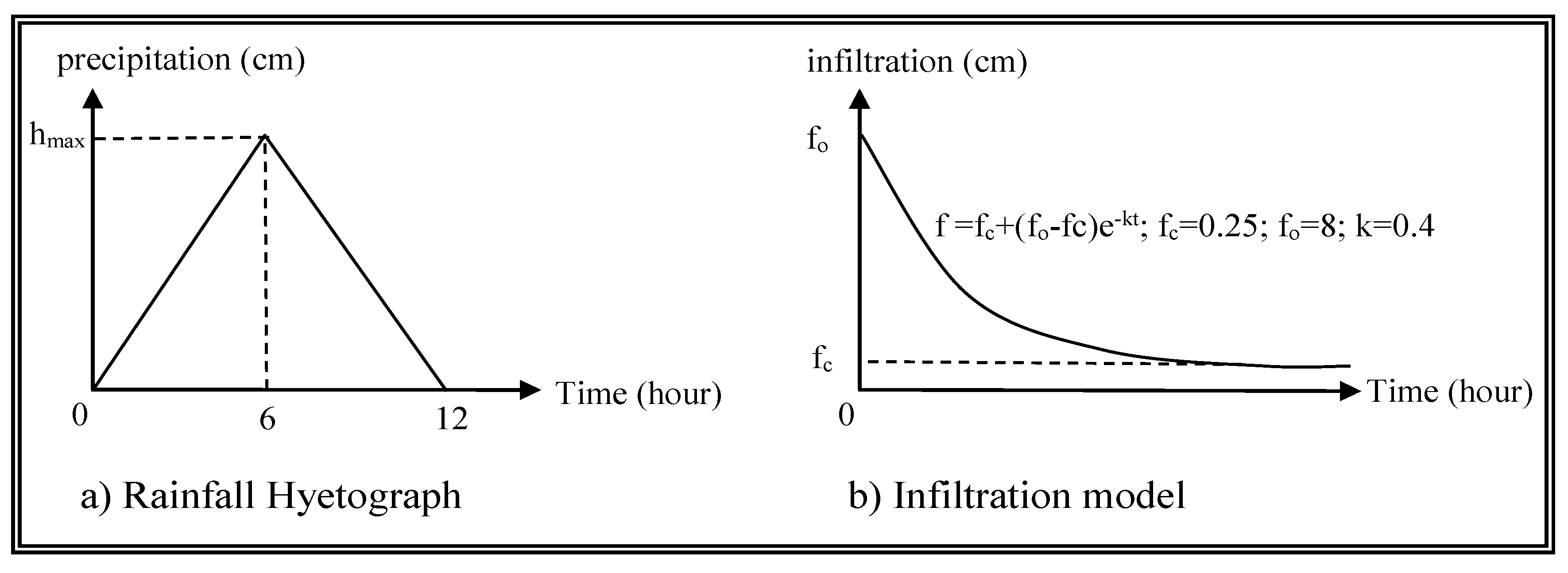
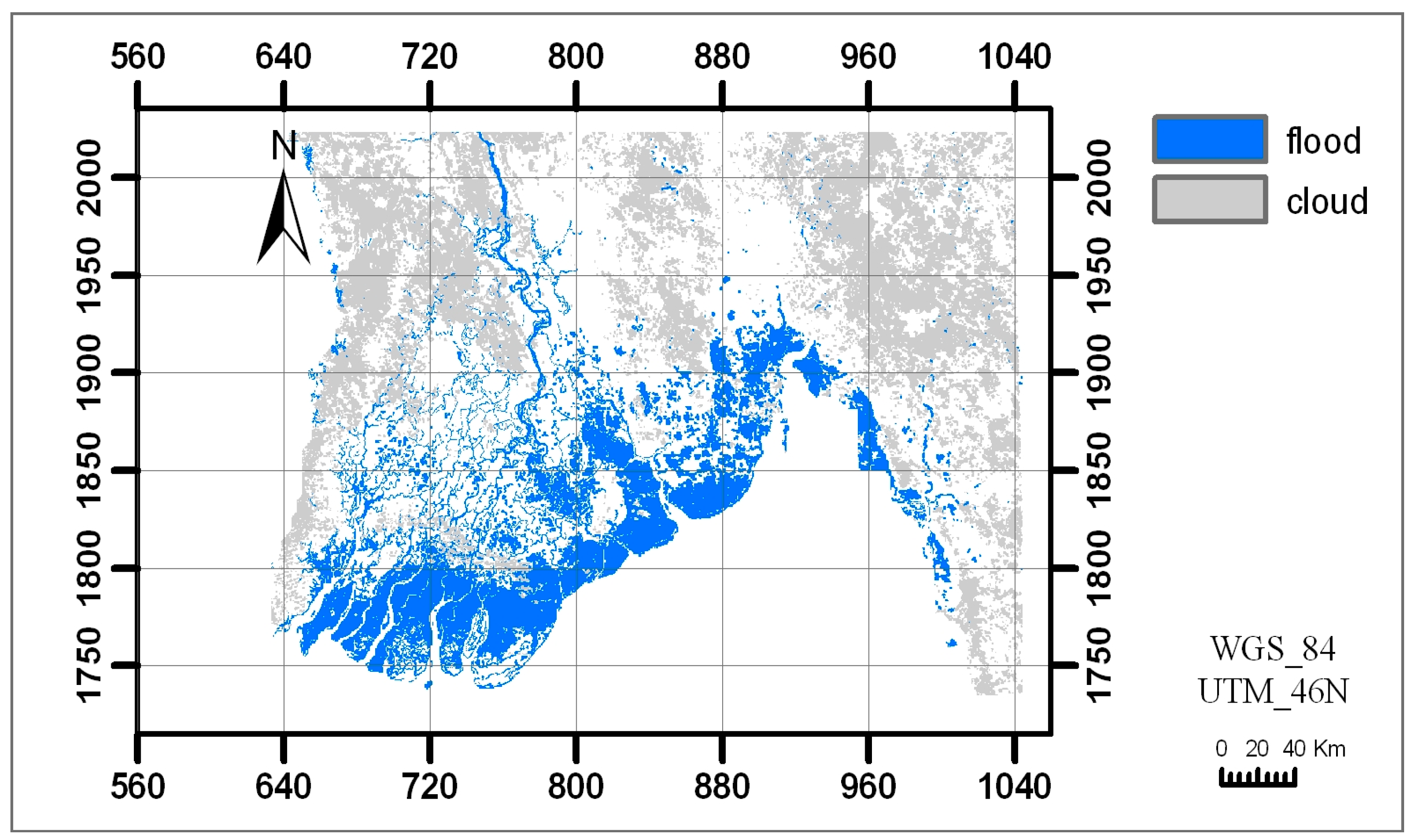
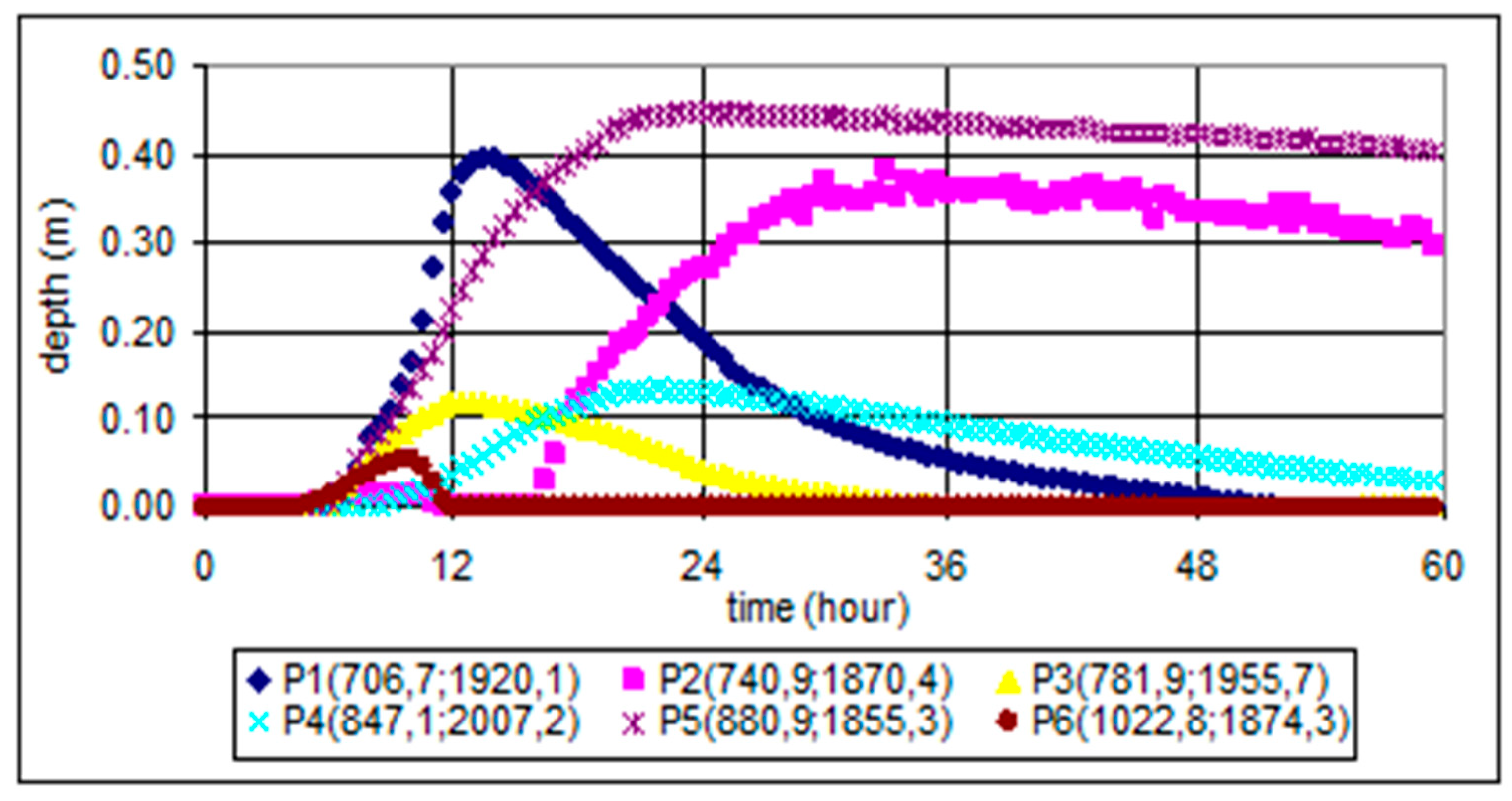
3.2. Flood Simulation for Cyclone Nargis
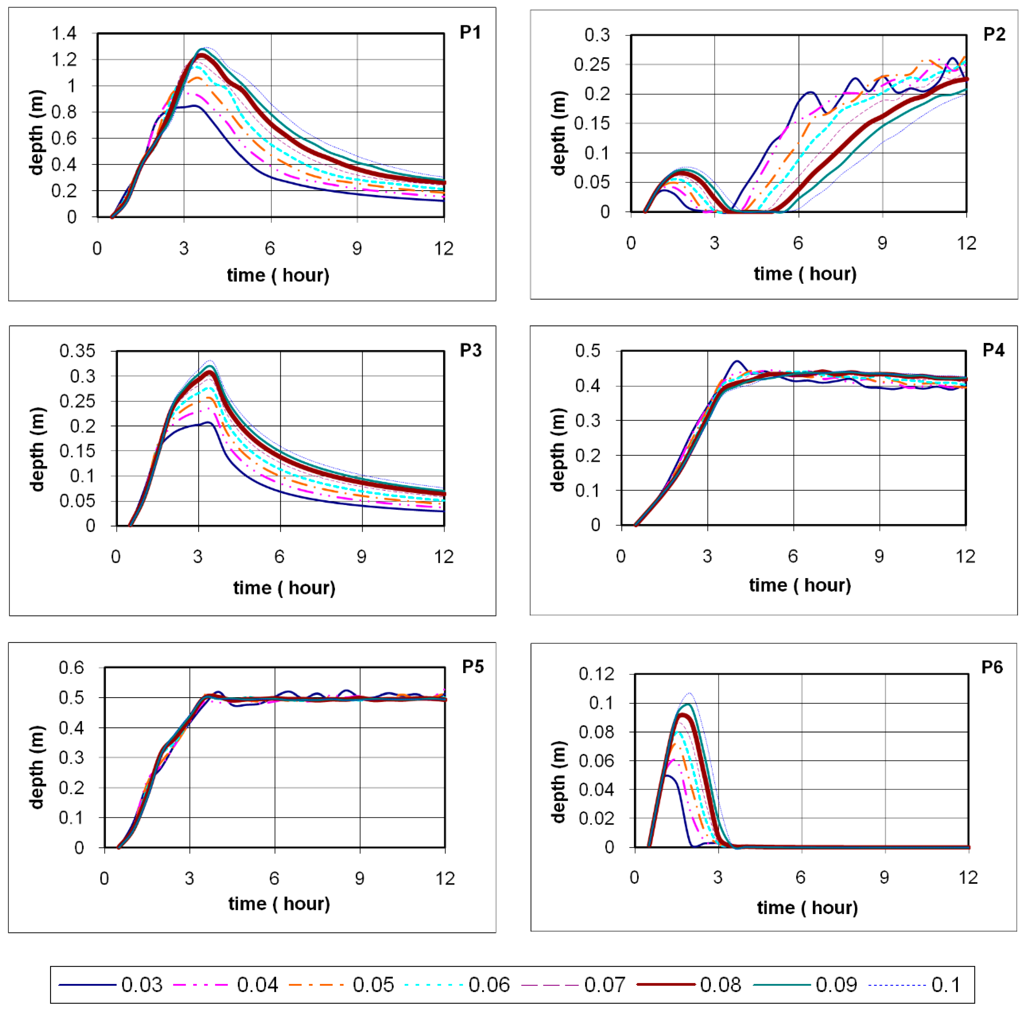
3.3. Sensitivity Analyses
4. Results
5. Discussion
5.1. Model
- Its helpfulness for rainfall-induced flood analysis of plain areas where the most of the population generally lives, and a watershed basin cannot be easily delineated.
- There is no need to use a predefined flood extent, and thus it is very beneficial to cope with defining dynamic flood boundaries.
- Its use of hydrodynamic principles.
- The pixel level consideration of basin topography, land cover and soil properties.
- The possibility of integrating different rainfall and infiltration models.
- The consideration of pixel-level changes in rainfall and infiltration.
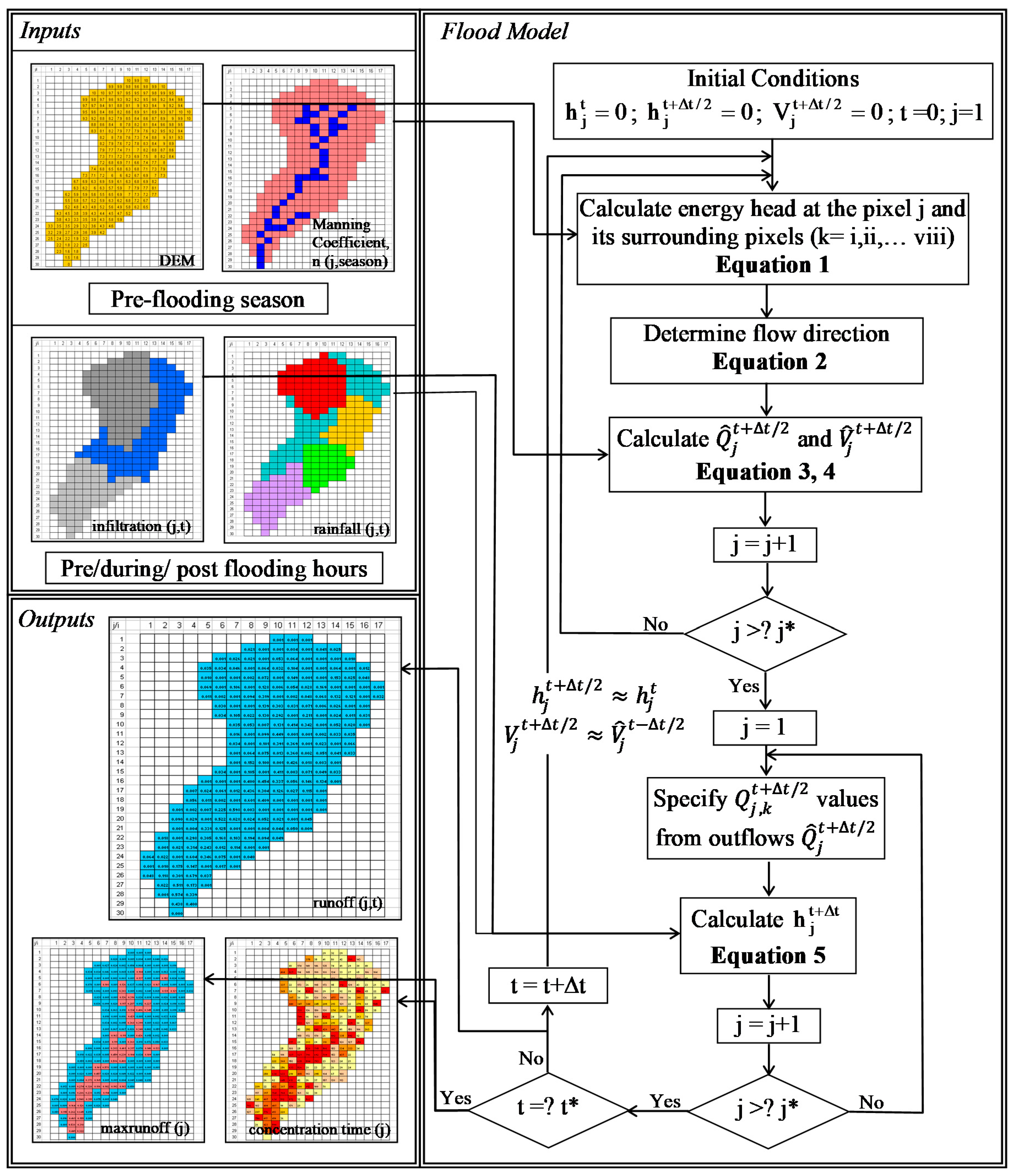
- The fast pre-modelling procedure due to the cellular automata processing.
- The temporal flood depth estimations at pixel level.
- The temporal flood extent estimations.
- The maximum flood depth and concentration time estimations at pixel level.
- Its practical application for disaster managers before, during and after disaster.
- Unlike classical hydrodynamic models, the proposed model cannot provide good estimations for floods within well-defined river courses due to the simplification of hydrodynamic principles.
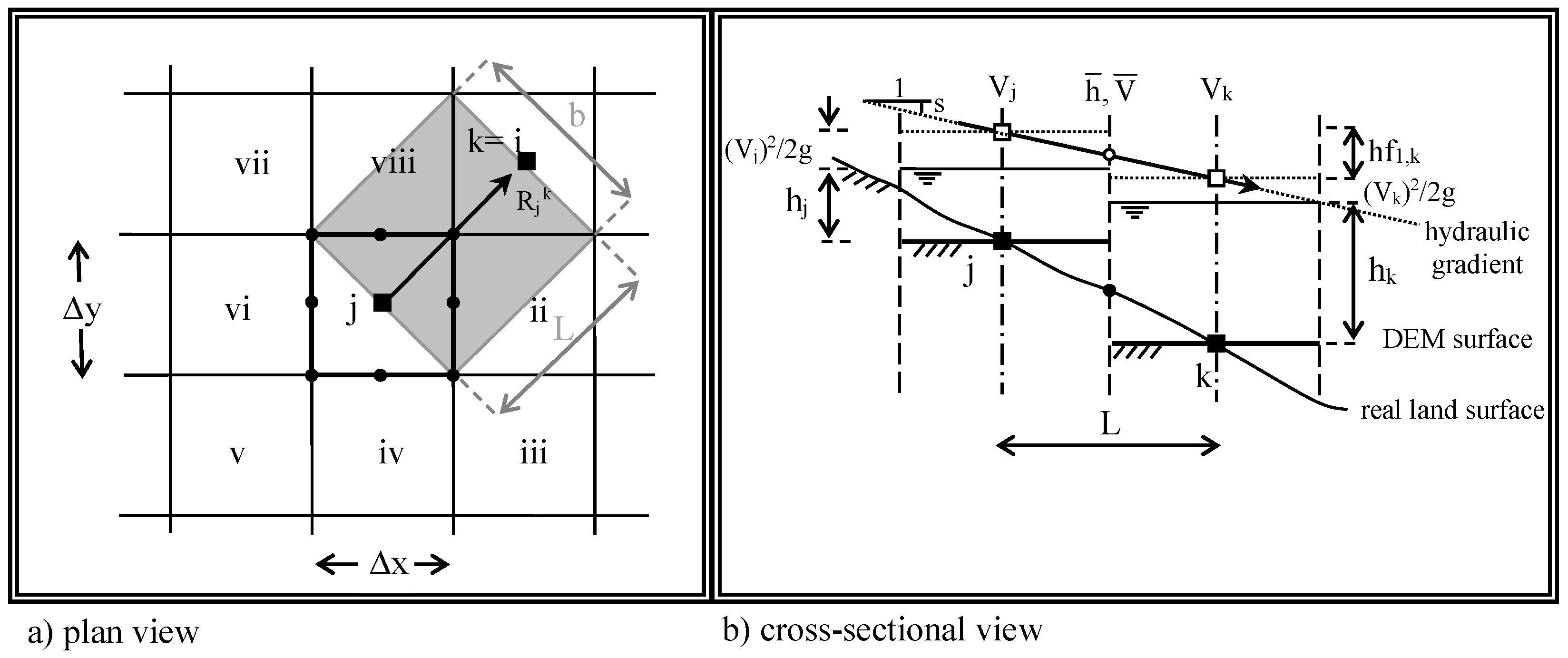
- The assumption of flow along the streamline excludes backwater effects and causes biases in calculated flow paths, for large spatial resolution; however, they can be negligible for small spatial resolutions and time intervals. The Courant Condition of the numerical stability [9] is applied in this study when spatial resolutions and time intervals are determined. Deviations from the flow path will be small for small pixels and automatically corrected along subsequent time steps due to the energy and mass conservation within pixels.
- Since the Manning equation relies on the assumption of fully turbulent flow, the model cannot accurately estimate low flood depths. Though laminar flow principles still can be included in this model, only high flood depths are the main concern for emergency managers.
- The speed of the cellular automata processing highly depends on the spatial resolution and time interval selected.
- The constant values assigned for natural wet areas to exclude them from analyses may cause underestimated flood depths in the pixels adjacent to small artificial ponds and narrow river tributary–sea intersections. For pixels located at the boundaries of the computational domain (i.e., first and last row and column), this assignment may cause either overestimation or underestimation depending on the direction of the maximum hydraulic gradient in these pixels. The potential solution to this problem is elimination of results obtained for these pixels.
- Upstream inflows or failure of engineering structures cannot be simulated by the proposed model. Full hydrodynamic models such as HEC (Hydraulic Engineering Center), SWMM (Storm Water Management Model) or MIKE series can provide good estimations for such simulations, especially when catchments and boundary conditions can be well defined. One solution for problems with upstream flows may be keeping study area large to include all the pixels in a considered basin and exclude results obtained for other pixels. This can be implemented readily by a GIS clipping function.
- The model may not easily simulate the impact of some engineering structures on the flow dynamics (e.g., obstructions from the bridge piers, flow regulation from dams and weirs, etc.).
5.2. Myanmar Flooding from Cyclone Nargis
- MODIS data lack ground truth control and validation.
- The MODIS image contains large cloud cover.
- MODIS data most likely include combined effect of storm surges and floods.
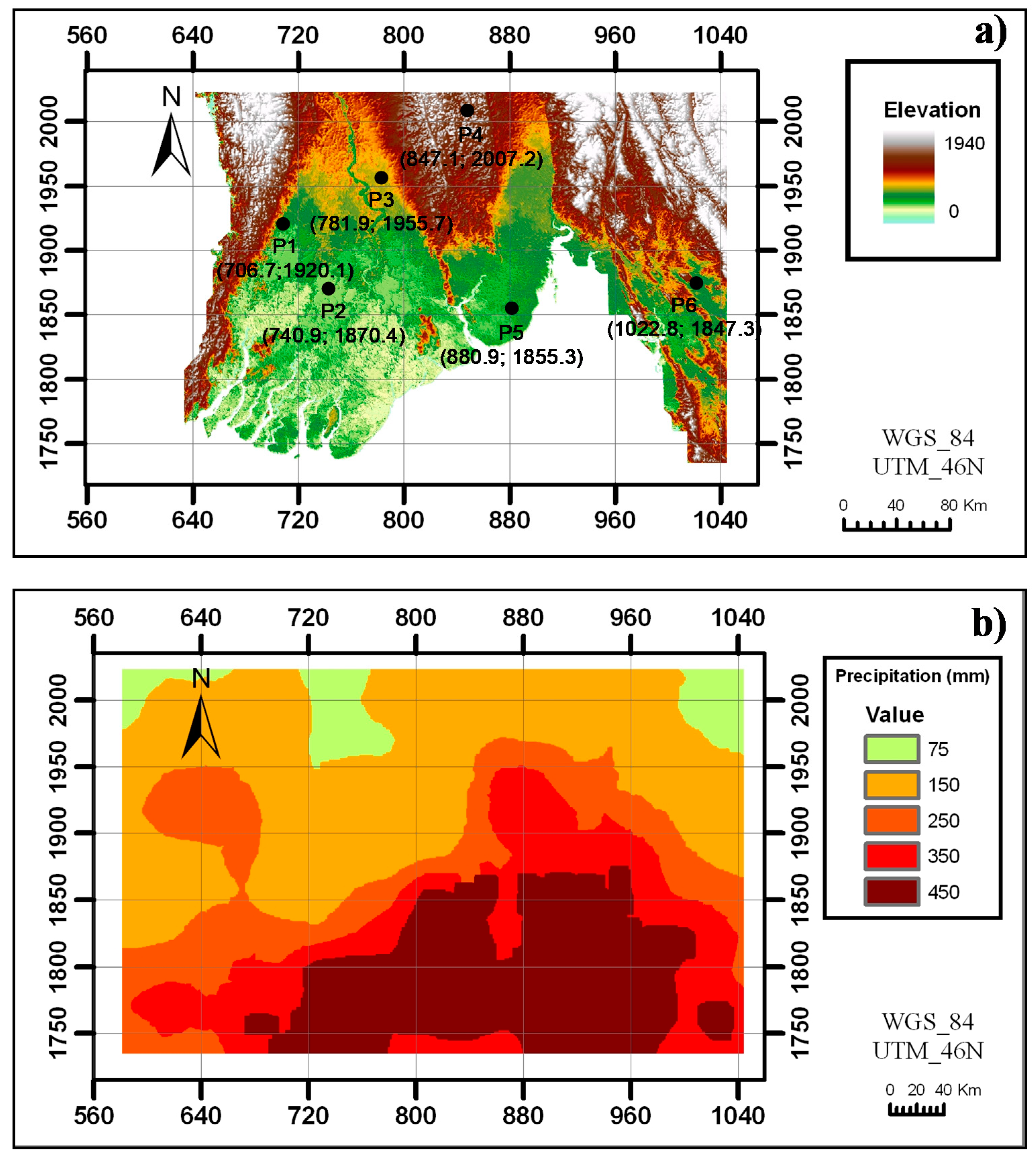
- The infiltration rate and Manning coefficient used in simulations may not represent the entire study area, and this could cause over/underestimations for some pixels.
5.3. Sensitivity Analyses
6. Conclusions
Author Contributions
Funding
Acknowledgments
Conflicts of Interest
References
- Khanna, R.K.; Agrawa, C.K.; Kumar, P. Remote sensing and GIS applications in flood management. In Proceedings of the First India Disaster Management Congress, New Delhi, India, 4–6 November 2006. [Google Scholar]
- Zerger, A.; Wealands, S. Beyond Modelling: Linking Models with GIS for Flood Risk Management. Nat. Hazards 2004, 33, 191–208. [Google Scholar] [CrossRef]
- Ozcelik, C. Generalized Models for Periodic Components of Monthly Flows; Dokuz Eylul University Graduate School of Natural and Applied Science: Izmir, Turkey, 2007. [Google Scholar]
- Liu, Y.B.; De Smedt, F. Flood Modeling for Complex Terrain Using GIS and Remote Sensed Information. Water Resour. Manag. 2005, 19, 605–624. [Google Scholar] [CrossRef]
- Plate, E.J. Flood risk and flood management. J. Hydrol. 2002, 267, 2–11. [Google Scholar] [CrossRef]
- Rossi, F.; Villani, P. Regional flood estimation methods. In Coping with Floods; Rossi, G., Harmancıoğlu, N., Yevjevich, V., Eds.; Springer: Berlin, Germany, 1994; pp. 135–169. [Google Scholar]
- Knebl, M.; Yang, Z.-L.; Hutchison, K.D.; Maidment, D. Regional scale flood modeling using NEXRAD rainfall, GIS, and HEC-HMS/RAS: A case study for the San Antonio River Basin, Summer 2002 storm event. J. Environ. Manag. 2005, 75, 325–336. [Google Scholar] [CrossRef]
- Ozga-Zielinska, M.; Gadek, W.; Ksiazynski, K.; Nachlik, E.; Szczepanek, R. The mathematical model of rainfall-runoff transformation- Wistooo. In Mathematical Models of Large Watershed Hydrology; Singh, V.P., Frevert, D.K., Eds.; Water Resources Publ.: Highlands Ranch, CO, USA, 2002; pp. 811–860. [Google Scholar]
- Chow, V.T.; Maidment, D.R.; Mays, L.W. Applied Hydrology; McGraw-Hill: New York, NY, USA, 1988; ISBN 0-07-010810-2. [Google Scholar]
- Kouwen, N.; Mousavi, S. Watflood/spl9, Hydrological model and flood forecasting system. In Mathematical Models of Large Watershed Hydrology; Singh, V.P., Frevert, D.K., Eds.; Water Resources Publ.: Highlands Ranch, CO, USA, 2002; pp. 649–685. [Google Scholar]
- Todini, E. The Arno model. In Mathematical Models of Large Watershed Hydrology; Singh, V.P., Frevert, D.K., Eds.; Water Resources Publ.: Highlands Ranch, CO, USA, 2002; pp. 687–716. [Google Scholar]
- Mutua, B.M.; Klik, A. Predicting daily streamflow in ungaged rural catchments: The case of Masinga catchment, Kenya. Hydrol. Sci. J. 2007, 52, 292–303. [Google Scholar] [CrossRef]
- Plate, E.J. Flood management as part of sustainable development. In Kassel Reports of Hydraulic Engineering; Tönsmann, F., Koch, M., Eds.; KIT: Karlsruhe, Baden-Württemberg, Germany, 2000; pp. F11–F24. [Google Scholar]
- Islam, M.M.; Sado, K. Assessment of the flooded areas in collaboration with land cover classification by using NOAA-AVHRR data with a digital elevation model; a case study in Bangladesh. In Proceedings of the 3rd Korea-Japan Bilateral Symposium on Water Resources and Environ Research, Seoul, Korea, 6–8 August 1998; pp. 132–137. [Google Scholar]
- Maidment, D. Handbook of Hydrology; McGraw-Hill: New York, NY, USA, 1993. [Google Scholar]
- Cobby, D.M.; Mason, D.C.; Horritt, M.S.; Bates, P. Two-dimensional hydraulic flood modelling using a finite-element mesh decomposed according to vegetation and topographic features derived from airborne scanning laser altimetry. Hydrol. Process. 2003, 17, 1979–2000. [Google Scholar] [CrossRef]
- Hjelmfelt, A.T. Investigation of Curve Number Procedure. J. Hydraul. Eng. 1991, 117, 725–737. [Google Scholar] [CrossRef]
- Leclerc, M.; Belemare, J.; Dumas, G.; Dhatt, G. A finite element model of estuarine and river flows with moving boundaries. Adv. Water Res. 1990, 13, 158–168. [Google Scholar] [CrossRef]
- Zhu, J. GIS Based Urban Flood Inundation Modeling. In Proceedings of the 2010 Second WRI Global Congress on Intelligent Systems, Wuhan, China, 16–17 December 2010. [Google Scholar] [CrossRef]
- Garrote, L.; Bras, R.L. A distributed model for real-time flood forecasting using digital elevation models. J. Hydrol. 1995, 167, 279–306. [Google Scholar] [CrossRef]
- Bates, P.D.; De Roo, A.P.J. A simple raster-based model for flood inunduation simulation. J. Hydrol. 2000, 236, 54–77. [Google Scholar] [CrossRef]
- Hunter, N.M.; Bates, P.; Horritt, M.; Wilson, M.D. Improved simulation of flood flows using storage cell models. Proc. Inst. Civ. Eng.-Water Manag. 2006, 159, 9–18. [Google Scholar] [CrossRef]
- Chaudhry, M.H. Open Channel Flow; Prentice-Hall: Englewood Cliffs, NJ, USA, 1992; ISBN 0-13-637141-8. [Google Scholar]
- Koutitas, C.G. Elements of Computational Hydraulics; Pentech Press Ltd.: London, UK, 1983; ISBN 0-7273-0503-4. [Google Scholar]
- Karvonen, T.; Koivusalo, H.; Jauhiainen, M.; Palko, J.; Weppling, K. A hydrological model for predicting runoff from different land use areas. J. Hydrol. 1999, 217, 253–265. [Google Scholar] [CrossRef]
- Zerger, A. Examining GIS decision utility for natural hazard risk modelling. Environ. Model. Softw. 2002, 17, 287–294. [Google Scholar] [CrossRef]
- Bates, P.D.; Horritt, M.S.; Smith, C.N.; Mason, D. Integrating remote sensing observations of flood hydrology and hydraulic modeling. Hydrol. Process. 1998, 11, 1777–1795. [Google Scholar] [CrossRef]
- Chen, J.; Hill, A.A.; Urbano, L. A GIS-based model for urban flood inundation. J. Hydrol. 2009, 373, 184–192. [Google Scholar] [CrossRef]
- Yamazaki, D.; Ikeshima, D.; Tawatari, R.; Yamaguchi, T.; O’Loughlin, F.E.; Neal, J.C.; Sampson, C.C.; Kanae, S.; Bates, P. A high-accuracy map of global terrain elevations. Geophys. Res. Lett. 2017, 44, 5844–5853. [Google Scholar] [CrossRef]
- Meng, X.; Zhang, M.; Wen, J.; Du, S.; Xu, H.; Wang, L.; Yang, Y. A Simple GIS-Based Model for Urban Rainstorm Inundation Simulation. Sustainability 2019, 11, 2830. [Google Scholar] [CrossRef]
- Tehrany, M.S.; Shabani, F.; Jebur, M.N.; Hong, H.; Pourghasemi, H.R.; Xie, X. GIS-based spatial prediction of flood prone areas using standalone frequency ratio, logistic regression, weight of evidence and their ensemble techniques. Geomat. Nat. Hazards Risk 2017, 8, 1538–1561. [Google Scholar] [CrossRef]
- Yamazaki, D.; Ikeshima, D.; Sosa, J.; Bates, P.; Allen, G.H.; Pavelsky, T.M. MERIT Hydro: A high-resolution global hydrography map based on latest topography datasets. Water Resour. Res. 2019, 55, 5053–5073. [Google Scholar] [CrossRef]
- Ferraro, D.; Costabile, P.; Costanzo, C.; Petaccia, G.; Macchione, F. A spectral analysis approach for the a priori generation of computational grids in the 2-D hydrodynamic-based runoff simulations at a basin scale. J. Hydrol. 2020, 582, 124508. [Google Scholar] [CrossRef]
- Costabile, P.; Costanzo, C.; De Bartolo, S.; Gangi, F.; Macchione, F.; Tomasicchio, G.R. Hydraulic Characterization of River Networks Based on Flow Patterns Simulated by 2-D Shallow Water Modeling: Scaling Properties, Multifractal Interpretation, and Perspectives for Channel Heads Detection. Water Resour. Res. 2019, 55, 7717–7752. [Google Scholar] [CrossRef]
- Cea, L.; Bladé, E. A simple and efficient unstructured finite volume scheme for solving the shallow water equations in overland flow applications. Water Resour. Res. 2015, 51, 5464–5486. [Google Scholar] [CrossRef]
- Nash, J.E. The form of the instantaneous unit hydrograph. IAHS Publ. 1957, 45, 114–121. [Google Scholar]
- Özçelik, C.; Benzeden, E. Regionalization approaches for the periodic parameters of monthly flows: A case study of Ceyhan and Seyhan River basins. Hydrol. Process. 2010, 24, 3251–3269. [Google Scholar] [CrossRef]
- Portmann, F.T. Hydrological runoff modelling by the use of remote sensing data with reference to the 1993–1994 and 1995 floods in the river Rhine catchment. Hydrol. Process. 1997, 11, 1377–1392. [Google Scholar] [CrossRef]
- ASCE. American society of civil engineers manuals and reports on engineering practice. In Hydrology Handbook, 2nd ed.; Amer Society of Civil Engineers: New York, NY, USA, 1996. [Google Scholar]
- Seyhan, E. Calculation of Runoff from Basin Physiographic Properties (CRBP). Ph.D. Thesis, Delft Technological University, Delf, The Netherlands, 1976. [Google Scholar]
- Roesner, L.A.; Yevjevich, V. Mathematical Models for Time Series of Monthly Precipitation and Monthly Runoff; Colorado State University Hydrology Papers; Colorado State University: Fort Collins, CO, USA, 1966; pp. 15–35. [Google Scholar]
- Gee, D.M.; Anderson, M.G.; Baird, L. Large-scale floodplain modelling. Earth Surf. Process. Landf. 1990, 15, 513–523. [Google Scholar] [CrossRef]
- Bates, P.; Anderson, M. A preliminary investigation into the impact of initial conditions on flood inundation predictions using a time/space distributed sensitivity analysis. Catena 1996, 26, 115–134. [Google Scholar] [CrossRef]
- Collier, C.G. Precipitation. In Remote Sensing in Hydrology and Water Management; Schultz, G.A., Engman, E.T., Eds.; Springer: Berlin, German, 2000; pp. 111–132. [Google Scholar]
- Engman, E.T. Soil Moisture. In Remote Sensing in Hydrology and Water Management; Schultz, G.A., Engman, E.T., Eds.; Springer: Berlin, German, 2000; pp. 197–216. [Google Scholar]
- Von-Neumann, J. Theory of Self-Replicating Automata; University of Illinois Press: Urbana, IL, USA, 1966. [Google Scholar]
- Ulam, S.M. Random processes and transformations. Proc. Int. Congr. Math 1952, 2, 264–275. [Google Scholar]
- White, R.; Engelen, G. Cellular automata as the basis of integrated dynamic regional modelling. Environ. Plan. B Plan. Des. 1997, 24, 235–246. [Google Scholar] [CrossRef]
- Wolfram, S. Cellular automata. Los Alamos Sci. 1983, 9, 2–21. [Google Scholar]
- Ahmad, S.; Simonovic, S. Spatial System Dynamics: New Approach for Simulation of Water Resources Systems. J. Comput. Civ. Eng. 2004, 18, 331–340. [Google Scholar] [CrossRef]
- Miller, J.R.; Russell, G.L.; Caliri, G. Continental-Scale River Flow in Climate Models. J. Clim. 1994, 7, 914–928. [Google Scholar] [CrossRef]
- Sausen, R.; Schubert, S.; Dümenil, L. A model of river runoff for use in coupled atmosphere-ocean models. J. Hydrol. 1994, 155, 337–352. [Google Scholar] [CrossRef]
- Naden, P.S. Spatial variability in flood estimation for large catchments: The exploitation of channel network structure. Hydrol. Sci. J. 1992, 37, 53–71. [Google Scholar] [CrossRef]
- Chu, X.; Yang, J.; Chi, Y.; Zhang, J. Dynamic puddle delineation and modeling of puddle-to-puddle filling-spilling-merging-splitting overland flow processes. Water Resour. Res. 2013, 49, 3825–3829. [Google Scholar] [CrossRef]
- Zhang, S.; Pan, B. An urban storm-inundation simulation method based on GIS. J. Hydrol. 2014, 517, 260–268. [Google Scholar] [CrossRef]
- Wu, Q.; Lane, C.R. Delineating wetland catchments and modeling hydrologic connectivity using lidar data and aerial imagery. Hydrol. Earth Syst. Sci. 2017, 21, 3579–3595. [Google Scholar] [CrossRef]
- Wu, Q.; Lane, C.R.; Wang, L.; Vanderhoof, M.K.; Christensen, J.R.; Liu, H. Efficient Delineation of Nested Depression Hierarchy in Digital Elevation Models for Hydrological Analysis Using Level-Set Method. JAWRA J. Am. Water Resour. Assoc. 2018, 55, 354–368. [Google Scholar] [CrossRef]
- Ozcelik, C.; Doğan, M. Investigation of wave attenuation mechanism under the downstream backwater effect. Flow Meas. Instrum. 2009, 20, 180–188. [Google Scholar] [CrossRef]
- Roberson, J.A.; Cassidy, J.J.; Chaudhry, M.H. Hydraulic Engineering, 2nd ed.; John Wiley & Sons Inc.: New York, NY, USA, 1997. [Google Scholar]
- Goodchild, M.F. Progress and Research Issues. GIS and Environment Modeling, 1st ed.; Wiley: New York, NY, USA, 1996; ISBN 0470236779. [Google Scholar]
- O’Callaghan, J.; Mark, D.M. The extraction of drainage networks from digital elevation data. Comput. Vis. Graph. Image Process. 1984, 28, 323–344. [Google Scholar] [CrossRef]
- Chahinian, N.; Moussa, R.; Andrieux, P.; Voltz, M. Comparison of infiltration models to simulate flood events at the field scale. J. Hydrol. 2005, 306, 191–214. [Google Scholar] [CrossRef]
- Horton, R.E. The Rôle of infiltration in the hydrologic cycle. Trans. Am. Geophys. Union 1933, 14, 446–460. [Google Scholar] [CrossRef]
- Ponce, V.M.; Hawkins, R.H. Runoff Curve Number: Has It Reached Maturity? J. Hydrol. Eng. 1996, 1, 11–19. [Google Scholar] [CrossRef]
- Philip, J. The theory of infiltration: 4. Sorptivity and albegraic infiltration equations. Soil Sci. 1957, 84, 257–264. [Google Scholar] [CrossRef]



| Threshold Depths Used to Obtain the Flood Extent Images (cm) | |||
|---|---|---|---|
| 5 | 2 | 1 | |
| Percentage, % | 57 | 71 | 77 |
© 2020 by the authors. Licensee MDPI, Basel, Switzerland. This article is an open access article distributed under the terms and conditions of the Creative Commons Attribution (CC BY) license (http://creativecommons.org/licenses/by/4.0/).
Share and Cite
Ozcelik, C.; Gorokhovich, Y. An Overland Flood Model for Geographical Information Systems. Water 2020, 12, 2397. https://doi.org/10.3390/w12092397
Ozcelik C, Gorokhovich Y. An Overland Flood Model for Geographical Information Systems. Water. 2020; 12(9):2397. https://doi.org/10.3390/w12092397
Chicago/Turabian StyleOzcelik, Ceyhun, and Yuri Gorokhovich. 2020. "An Overland Flood Model for Geographical Information Systems" Water 12, no. 9: 2397. https://doi.org/10.3390/w12092397
APA StyleOzcelik, C., & Gorokhovich, Y. (2020). An Overland Flood Model for Geographical Information Systems. Water, 12(9), 2397. https://doi.org/10.3390/w12092397


