Tidally Forced Saltwater Intrusions might Impact the Quality of Drinking Water, the Valdivia River (40° S), Chile Estuary Case

 ,
,  , ,
, ,
Abstract
1. Introduction
2. Materials and Methods
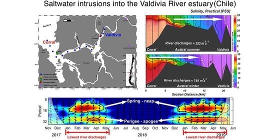
2.1. Study Area
2.2. Documented Seawater Intrusion in the VRE
2.3. Data
2.3.1. Moored Sensors and Hydrographic Stations along the VRE
2.3.2. River Runoff
2.4. Methods
2.4.1. Tidal Analysis
2.4.2. Cross Wavelet Transformation
2.4.3. Determination of the Extent of Saltwater Intrusion
2.4.4. Relationship between Saltwater Intrusion and River Discharge
3. Results
3.1. Extension of Saline Water Intrusions along the Central Axis of the VRE
3.2. Harmonic Analysis of Tides
3.3. Sub-Tidal Variability at Station Lido
3.4. River Discharge and Intra-Tidal Constituents Control Salinity at the Lido and Valdivia Stations
4. Discussion
4.1. Extension of Saline Water Intrusions along the Central Axis of the VRE
4.2. River Discharge and Tidal Constituents Control Salinity at the Lido and Valdivia Stations
4.3. Implications of Saltwater Intrusions for the Provider of Drinking Water for Valdivia City
5. Conclusions
Author Contributions
Funding
Acknowledgments
Conflicts of Interest
References
- Van der Tuin, H. Guidelines on the Study of Seawater Intrusion into Rivers. Prepared for the International Hydrological Programme by the Working Group of Project 4.4b (IHP-III); UNESCO: Paris, France, 1991; p. 138. [Google Scholar]
- Baten, M.A.; Seal, L.; Lisa, K.S. Salinity Intrusion in Interior Coast of Bangladesh: Challenges to Agriculture in South-Central Coastal Zone. Am. J. Clim. Chang. 2015, 4, 248–262. [Google Scholar] [CrossRef]
- Liu, B.J.; Yan, S.L.; Chen, X.H.; Lian, Y.Q.; Xin, Y.B. Wavelet analysis of the dynamic characteristics of saltwater intrusion—A case study in the Pearl River Estuary of China. Ocean Coast. Manag. 2014, 95, 81–92. [Google Scholar] [CrossRef]
- Gong, W.P.; Shen, J. The response of salt intrusion to changes in river discharge and tidal mixing during the dry season in the Modaomen Estuary, China. Cont. Shelf Res. 2011, 31, 769–788. [Google Scholar] [CrossRef]
- Croucher, A.E.; O’Sullivan, M.J. The Henry Problem for Saltwater Intrusion. Water Resour. Res. 1995, 31, 1809–1814. [Google Scholar] [CrossRef]
- Zidane, A.; Younes, A.; Huggenberger, P.; Zechner, E. The Henry semianalytical solution for saltwater intrusion with reduced dispersion. Water Resour. Res. 2012, 48. [Google Scholar] [CrossRef]
- Movellán, E. Modelado de la Cuña Salina y del Flujo de Nutrientes en el Tramo Estuarino del río Ebro. Ph.D. Thesis, Universidad de Barcelona, Barcelona, Spain, 2004. [Google Scholar]
- Tomczak, M. Definition of Estuaries; Empirical Estuary Classification. Available online: http://www.es.flinders.edu.au/~mattom/ShelfCoast/chapter11.html (accessed on 5 May 2020).
- Jay, D.A. Estuarine variability. In Contemporary Issues in Estuarine Physics; Valle-Levinson, A., Ed.; Cambridge University Press: Cambridge, UK; New York, NY, USA, 2010; pp. 62–99. [Google Scholar] [CrossRef]
- Qiu, C.; Wan, Y.S. Time series modeling and prediction of salinity in the Caloosahatchee River Estuary. Water Resour. Res. 2013, 49, 5804–5816. [Google Scholar] [CrossRef]
- Perillo, G.M.E.; Piccolo, M.C.; Pino-Quivira, M. Estuaries of South America: Their Geomorphology and Dynamics; Springer: Berlin, Germany, 1999; p. 223. [Google Scholar] [CrossRef]
- Arcos, D.; Peña, H.; Nuñez, S.; Ortiz, J.; Furet, L.; Figueroa, S.; Sepúlveda, A.; Rebolledo, H.; Castillo, J.; Turner, A.; et al. Determinación de la Capacidad de Carga de las Zonas Estuarinas de los ríos Valdivia y Bueno, X Región; Instituto de Investigación Pesquera VIII Región: Talcahuano, Chile, 2002; p. 333. [Google Scholar]
- Garcés-Vargas, J.; Ruiz, M.; Pardo, L.M.; Nuñez, S.; Pérez-Santos, I. Hydrographic features of Valdivia river estuary south-central Chile. Lat. Am. J. Aquat. Res. 2013, 41, 113–125. [Google Scholar] [CrossRef]
- Ormeño, D. ¿Has notado cambio en el sabor del agua en Valdivia? AguasDecima entregó la explicación. Río en Linea 2015. Available online: http://www.rioenlinea.cl/salud-2/6437-has-notado-cambio-en-el-sabor-del-agua-en-valdivia-aguasdecima-entrego-la-explicacion (accessed on 10 March 2018).
- Valdovinos, C. Ecosistemas Estuarinos (Capítulo 18). In Biología Marina y Oceanografía: Conceptos y Procesos; Werlinger, C.L., Ed.; Fondo Nacional del Libro y la Lectura: Concepción, Chile, 2004; pp. 397–414. [Google Scholar]
- Pantoja, S.; Iriarte, J.L.; Daneri, G. Oceanography of the Chilean Patagonia. Cont. Shelf Res. 2011, 31, 149–153. [Google Scholar] [CrossRef]
- WWF. Findings and Recommendation Report: WWF International Assessment Mission for the Carlos Anwandter Nature Sanctuary and CELCO Pulp Mill Controversy in Valdivia, Chile; WWF: Valdivia, Chile, 2005; p. 24. [Google Scholar]
- SHOA. Atlas Hidrográfico de Chile, 6th ed.; SHOA: Valparaíso, Chile, 2001. [Google Scholar]
- UACh. Programa de Diagnóstico Ambiental del Humedal del Río Cruces y sus Ríos Tributarios: 2014–2015; Universidad Austral de Chile: Valdivia, Chile, 2015; p. 1508. [Google Scholar]
- Pino, M.; Perillo, G.M.E.; Santamarina, P. Residual Fluxes in a Cross-Section of the Valdivia River Estuary, Chile. Estuar. Coast. Shelf Sci. 1994, 38, 491–505. [Google Scholar] [CrossRef]
- Jay, D.A.; Smith, J.D. Circulation, Density Distribution and Neap-Spring Transitions in the Columbia River Estuary. Prog. Oceanogr. 1990, 25, 81–112. [Google Scholar] [CrossRef]
- UACh. Estudio Sobre Origen de Mortalidades y Disminución Poblacional de aves Acuáticas en el Santuario de la Naturaleza Carlos Anwandter, en la Provincia de Valdivia; Universidad Austral de Chile: Valdivia, Chile, 2005; p. 443. [Google Scholar]
- Riquelme, O. $5.200 millones pagará empresa Arauco por daño ambiental en Santuario del río Cruces. El Mercurio 2014. Available online: http://impresa.elmercurio.com/Pages/NewsDetail.aspx?dt=2014-01-18&dtB=18-01-2014%200:00:00&PaginaId=12&bodyid=3date (accessed on 10 May 2020).
- Codiga, D.L. Unified Tidal Analysis and Prediction Using the Utide Matlab Functions. Technical Report 2011-01; Graduate School of Oceanography, University of Rhode Island: Narragansett, RI, USA, 2011; p. 59. [Google Scholar]
- Grinsted, A.; Moore, J.C.; Jevrejeva, S. Application of the cross wavelet transform and wavelet coherence to geophysical time series. Nonlinear Process Geophys. 2004, 11, 561–566. [Google Scholar] [CrossRef]
- Becker, M.L.; Luettich, R.A.; Mallin, M.A. Hydrodynamic behavior of the Cape Fear River and estuarine system: A synthesis and observational investigation of discharge-salinity intrusion relationships. Estuar. Coast. Shelf Sci. 2010, 88, 407–418. [Google Scholar] [CrossRef]
- Open University Course Team. Waves, Tides, and Shallow-Water Processes; Pergamon Press: Oxford, UK; New York, NY, USA, 1999; p. 228. [Google Scholar] [CrossRef]
- Valle-Levinson, A. (Ed.) Definition and classification of estuaries. In Contemporary Issues in Estuarine Physics; Cambridge University Press: Cambridge, UK; New York, NY, USA, 2010; pp. 1–11. [Google Scholar] [CrossRef]
- Haddout, S.; Baimik, I.; Maslouhi, A.; Igouzal, M.; Magrane, B.; Marah, H. The influence of spring and neap tide on salt intrusion and stratification in Sebou estuary (Morocco). Int. J. River Basin Manag. 2019, 17, 131–142. [Google Scholar] [CrossRef]
- Becker, M.L.; Luettich, R.A.; Seim, H. Effects of intratidal and tidal range variability on circulation and salinity structure in the Cape Fear River Estuary, North Carolina. J. Geophys. Res.-Ocean. 2009, 114. [Google Scholar] [CrossRef]
- Monismith, S.G.; Burau, J.R.; Stacey, M.T. Stratification dynamics and gravitational circulation in northern San Francisco Bay. In San Francisco Bay: The Ecosystem; Hollibaugh, J.T., Ed.; American Association for the Advancement of Science: Washington, DC, USA, 1996; pp. 123–153. [Google Scholar]
- Joordens, J.C.A.; Souza, A.J.; Visser, A. The influence of tidal straining and wind on suspended matter and phytoplankton distribution in the Rhine outflow region. Cont. Shelf Res. 2001, 21, 301–325. [Google Scholar] [CrossRef]
- Zhang, Z.; Cui, B.; Zhao, H.; Fan, X.; Zhang, H. Discharge-salinity relationships in Modaomen waterway, Pearl River estuary. Procedia Environ. Sci. 2010, 2, 1235–1245. [Google Scholar] [CrossRef]
- Quintana, J.M.; Aceituno, P. Changes in the rainfall regime along the extratropical west coast of South America (Chile): 30–43° S. Atmosfera 2012, 25, 1–22. [Google Scholar]
- Dai, A.; Qian, T.T.; Trenberth, K.E.; Milliman, J.D. Changes in Continental Freshwater Discharge from 1948 to 2004. J. Clim. 2009, 22, 2773–2792. [Google Scholar] [CrossRef]
- Palma, L. Central Hidroeléctrica San Pedro. El Cuestionado Proyecto de Colbun S.A.; Ediciones Kultrún: Valdivia, Chile, 2019; p. 150. [Google Scholar]
- Hutton, P.H.; Rath, J.S.; Chen, L.; Ungs, M.J.; Roy, S.B. Nine Decades of Salinity Observations in the San Francisco Bay and Delta: Modeling and Trend Evaluations. J. Water Resour. Plan. Manag. 2016, 142, 04015069. [Google Scholar] [CrossRef]
- Garreaud, R.D.; Boisier, J.P.; Rondanelli, R.; Montecinos, A.; Sepúlveda, H.H.; Veloso-Aguila, D. The Central Chile Mega Drought (2010–2018): A climate dynamics perspective. Int. J. Clim. 2020, 40, 421–439. [Google Scholar] [CrossRef]
- Collins, M.; Knutti, R.; Arblaster, J.; Dufresne, J.-L.; Fichefet, T.; Friedlingstein, P.; Gao, X.; Gutowski, W.J.; Johns, T.; Krinner, G.; et al. Long-term climate change: Projections, commitments and irreversibility. In Climate Change 2013: The Physical Science Basis. Contribution of Working Group I to the Fifth Assessment Report of the Intergovernmental Panel on Climate Change; Stocker, T.F., Qin, D., Plattner, G.-K., Tignor, M., Allen, S.K., Boschung, J., Nauels, A., Xia, Y., Bex, V., Midgley, P.M., Eds.; Cambridge University Press: Cambridge, UK; New York, NY, USA, 2013; pp. 1029–1136. [Google Scholar]


| Season | Date of Sampling | |
|---|---|---|
| Neap Tide | Spring Tide | |
| Austral spring | 29/11/2017 | 06/12/2017 |
| Austral summer | 11/01/2018 | 01/02/2018 |
| Austral fall | 08/05/2018 | 17/05/2018 |
| Austral winter | 19/08/2018 | 12/08/2018 |
| Method | Linear Regression | Power Regression | Exponential | |||
|---|---|---|---|---|---|---|
| Model | R2 | Model | R2 | Regression Model | R2 | |
| Hydrologic flood | y = −0.002895x + 18.30 | 0.55 | y = 66.86x−1/4.46 | 0.69 | y = 18.64e−0.0002x | 0.56 |
| Complete hydrologic flood | y = −0.002227x + 18.13 | 0.55 | y = 63.09x−1/4.75 | 0.70 | y = 18.42e−0.0002x | 0.56 |
| Complete value | y = −0.009129x + 20.79 | 0.72 | y = 163.6x−1/2.64 | 0.88 | y = 22.41e−0.0007x | 0.77 |
| Averaging | y = −0.008321x + 20.28 | 0.53 | y = 117.9x−1/3.08 | 0.53 | y = 21.20e−0.0006x | 0.53 |
| Complete averaging | y = −0.007197x + 19.98 | 0.64 | y = 121.9x−1/3.00 | 0.77 | y = 20.98e−0.0005x | 0.67 |
| Harmonic Constituent | Period (h) | Lido Amplitude * (m) | Lido Greenwich Phase Lag (°) | Lido % Explained | Valdivia Amplitude * (m) | Valdivia Greenwich Phase Lag (°) | Valdivia % Explained |
|---|---|---|---|---|---|---|---|
| Luni-solar Diurnal (K1) | 23.93 | 0.132 | 36.51 | 9.83 | 0.130 | 26.50 | 9.90 |
| Principal lunar Diurnal (O1) | 25.82 | 0.094 | 357.57 | 4.97 | 0.096 | 349.61 | 5.40 |
| Principal Lunar Semi-diurnal (M2) | 12.42 | 0.327 | 41.22 | 60.45 | 0.346 | 30.52 | 69.80 |
| Principal solar Semi-diurnal (S2) | 12.00 | 0.114 | 51.75 | 7.39 | 0.121 | 42.71 | 8.56 |
| Larger lunar elliptic Semi-diurnal (N2) | 12.66 | 0.072 | 18.85 | 2.93 | 0.073 | 7.81 | 3.15 |
| Year | January | February | March | April | ||||
|---|---|---|---|---|---|---|---|---|
| Mean | Standard Deviation | Mean | Standard Deviation | Mean | Standard Deviation | Mean | Standard Deviation | |
| 2018 | 1.89 | 0.54 | 1.78 | 0.70 | 1.81 | 0.70 | * | * |
| 2019 | 1.91 | 0.78 | 2.02 | 0.76 | 1.89 | 0.92 | 1.75 | 0.81 |
© 2020 by the authors. Licensee MDPI, Basel, Switzerland. This article is an open access article distributed under the terms and conditions of the Creative Commons Attribution (CC BY) license (http://creativecommons.org/licenses/by/4.0/).
Share and Cite
Garcés-Vargas, J.; Schneider, W.; Pinochet, A.; Piñones, A.; Olguin, F.; Brieva, D.; Wan, Y. Tidally Forced Saltwater Intrusions might Impact the Quality of Drinking Water, the Valdivia River (40° S), Chile Estuary Case. Water 2020, 12, 2387. https://doi.org/10.3390/w12092387
Garcés-Vargas J, Schneider W, Pinochet A, Piñones A, Olguin F, Brieva D, Wan Y. Tidally Forced Saltwater Intrusions might Impact the Quality of Drinking Water, the Valdivia River (40° S), Chile Estuary Case. Water. 2020; 12(9):2387. https://doi.org/10.3390/w12092387
Chicago/Turabian StyleGarcés-Vargas, José, Wolfgang Schneider, Andre Pinochet, Andrea Piñones, Francisco Olguin, Daniel Brieva, and Yongshan Wan. 2020. "Tidally Forced Saltwater Intrusions might Impact the Quality of Drinking Water, the Valdivia River (40° S), Chile Estuary Case" Water 12, no. 9: 2387. https://doi.org/10.3390/w12092387
APA StyleGarcés-Vargas, J., Schneider, W., Pinochet, A., Piñones, A., Olguin, F., Brieva, D., & Wan, Y. (2020). Tidally Forced Saltwater Intrusions might Impact the Quality of Drinking Water, the Valdivia River (40° S), Chile Estuary Case. Water, 12(9), 2387. https://doi.org/10.3390/w12092387