Analysis of the Most Severe Flood Events in Turkey (1960–2014): Which Triggering Mechanisms and Aggravating Pathways Can be Identified?


Abstract
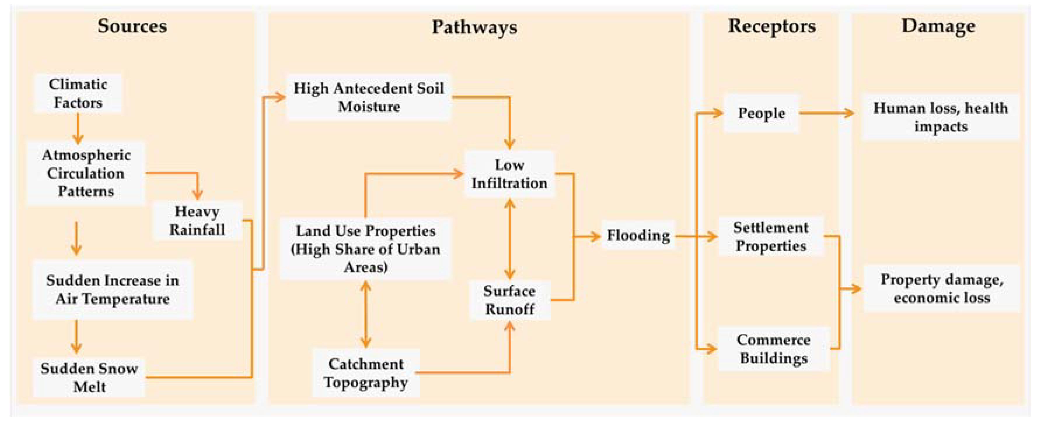
1. Introduction
2. Study Area, Datasets, and Methods
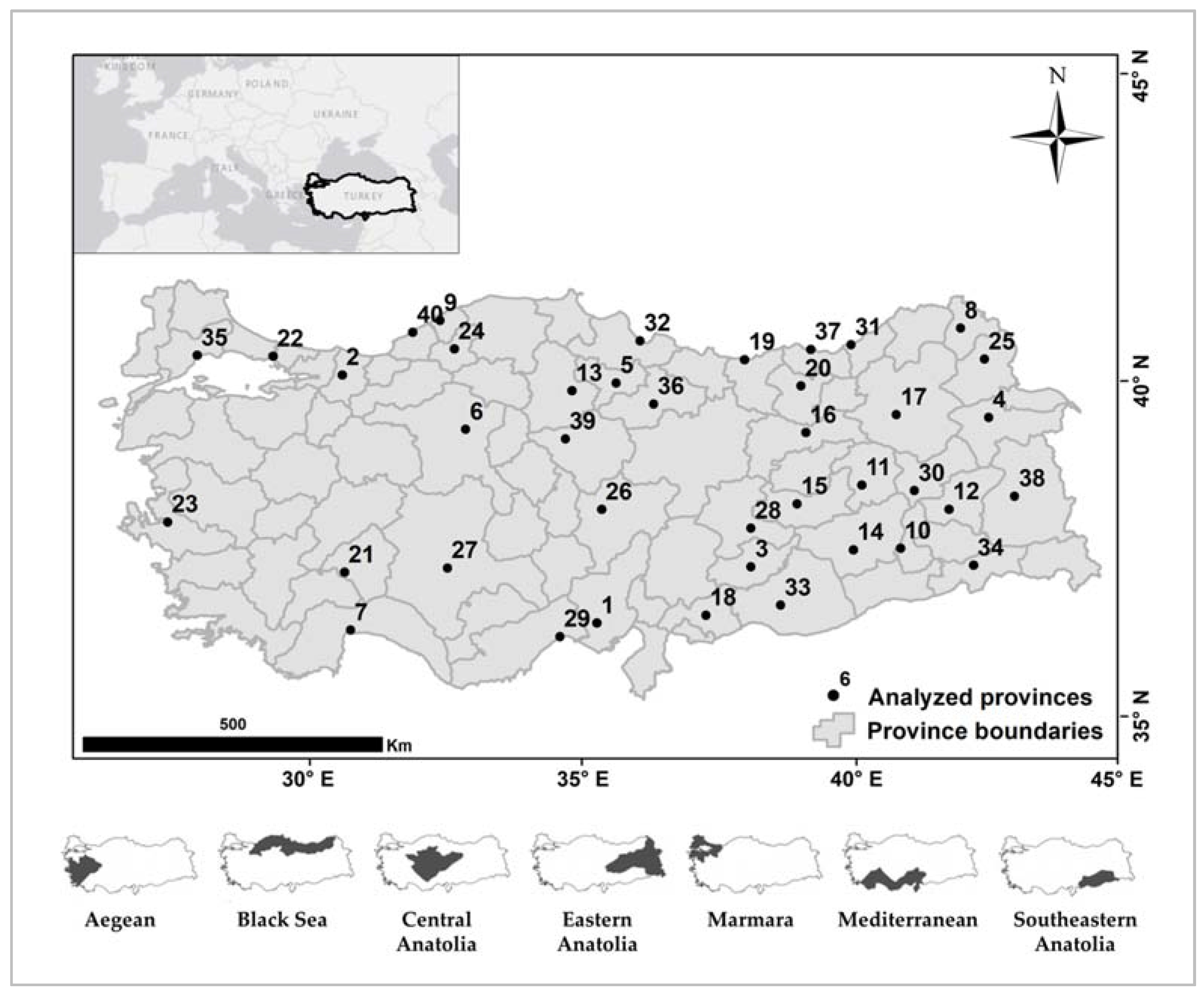
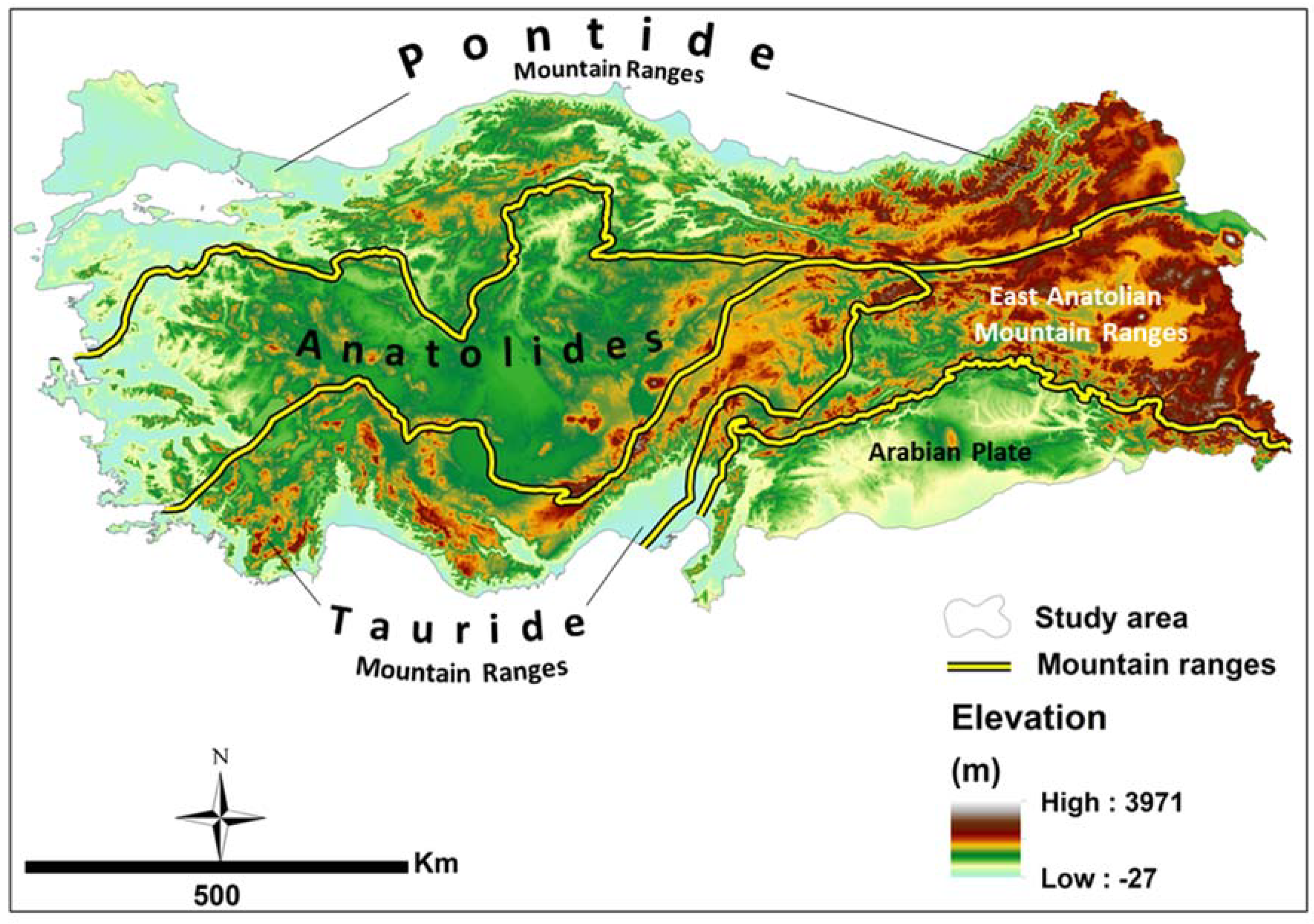
2.1. Study Area
2.2. Datasets
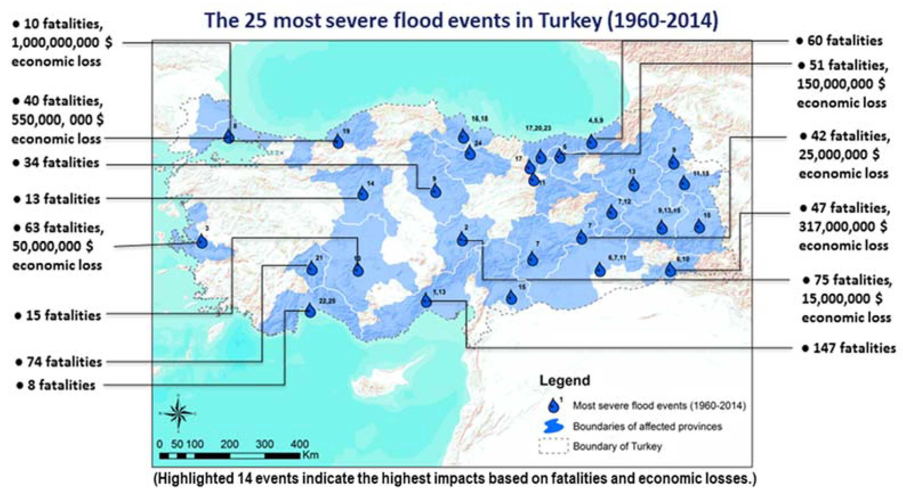
2.2.1. The 25 Most Severe Flood Events
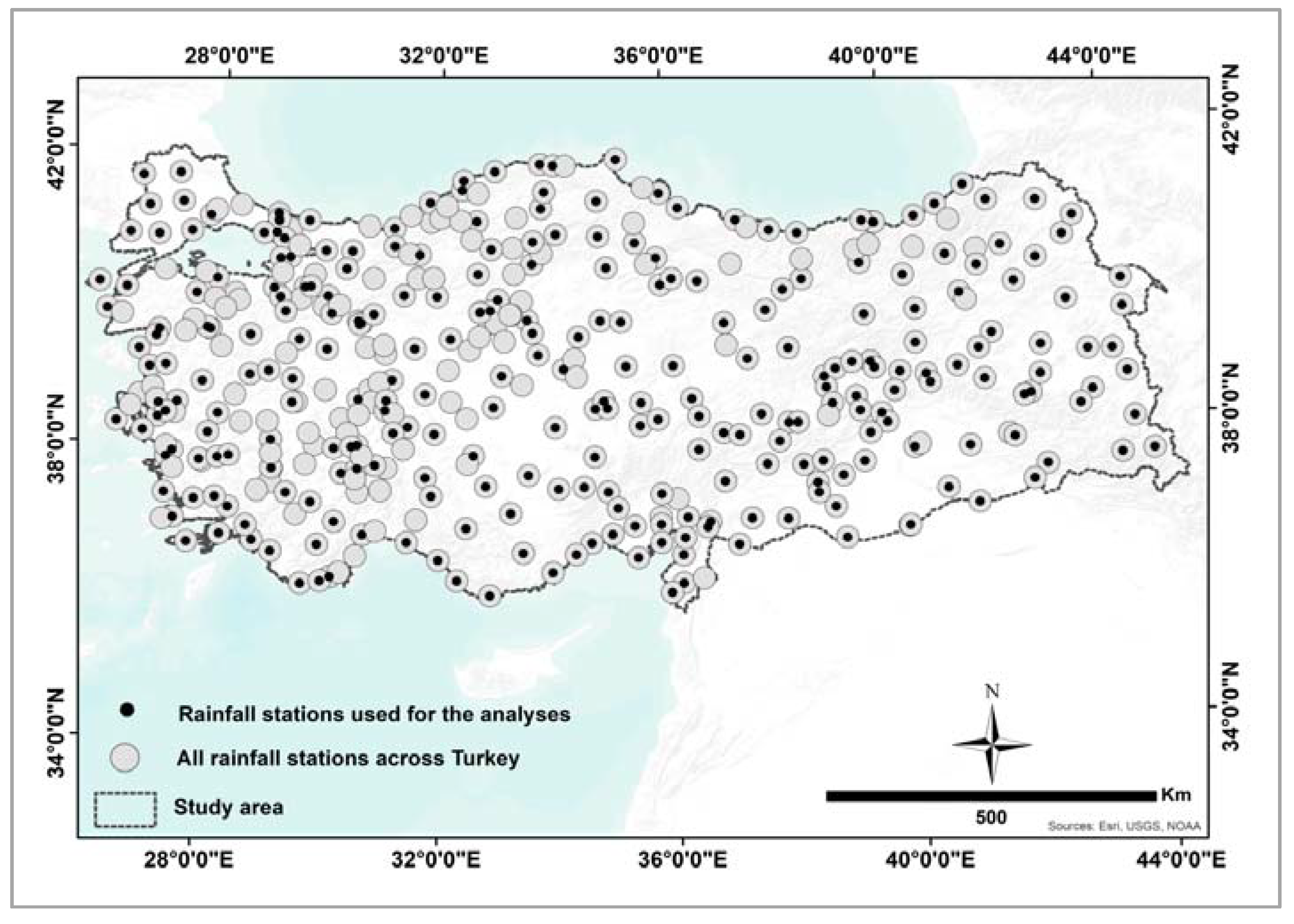
2.2.2. Daily Precipitation Data (Turkish State Meteorological Service Dataset, 1960–2014)
2.2.3. ERA5—Climate Reanalysis Data
2.2.4. Hess and Brezowsky Großwetterlagen Catalog (HB-GWL, 1881–2016)
2.2.5. Digital Elevation Model (CGIAR-CSI SRTM, 90 m v.4)
2.2.6. Soil Map of Turkey (BTG, 1987)
2.2.7. Corine Land Cover Data (CLC 2012)
2.3. Methods
2.3.1. Event Day Precipitation (PREC)
2.3.2. Determination of the Atmospheric Circulation Pattern Types (ACPs)
2.3.3. Determination of the Antecedent Soil Moisture (ASM) Parameter
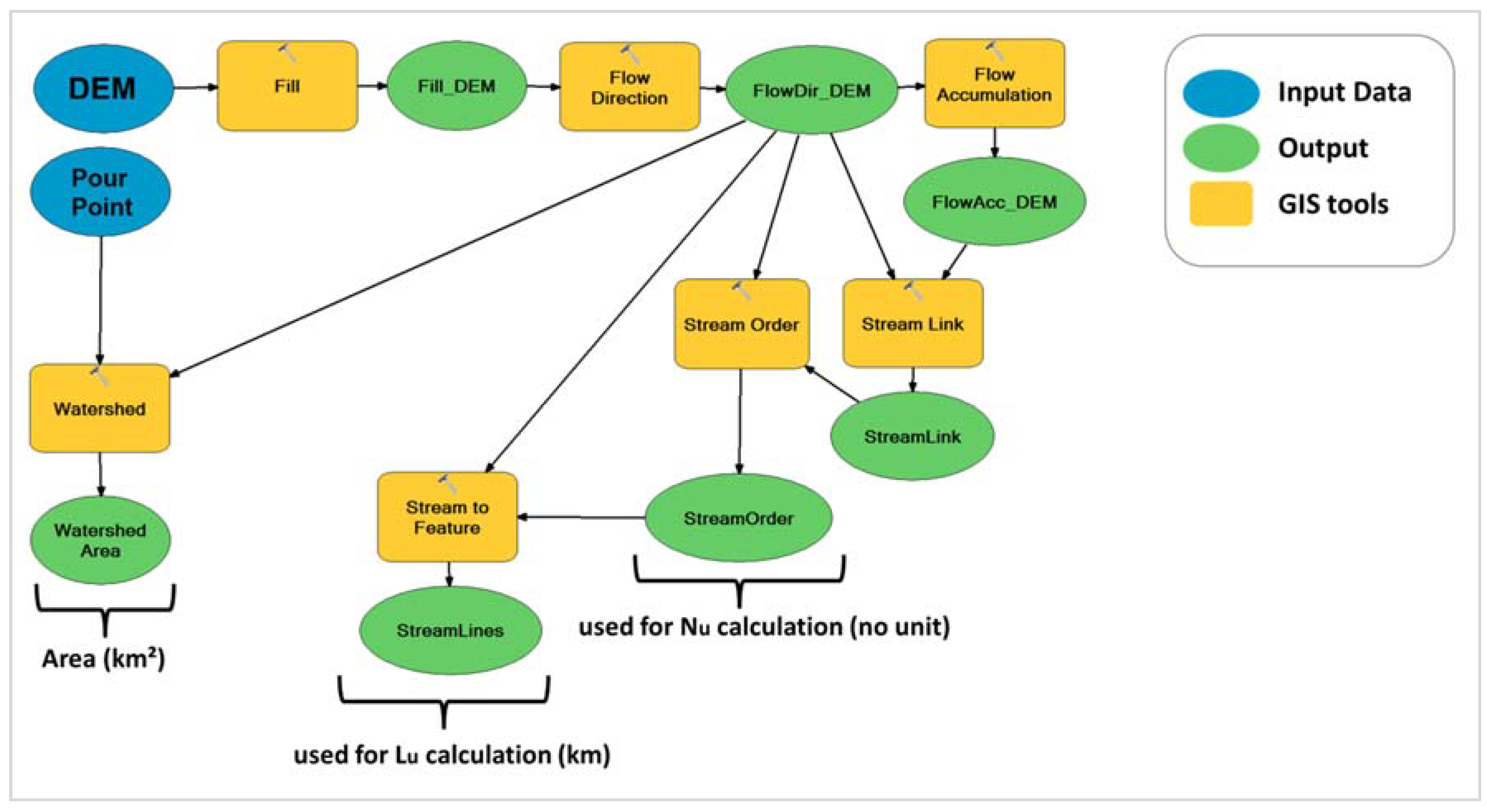
2.3.4. Calculation of the Infiltration Number (IN) and the Total Catchment Area (TCA)
2.3.5. Calculation of the Infiltration Rate (IR)
2.3.6. Determination of Urbanized Areas (UA) and Water Bodies (WB) Parameters
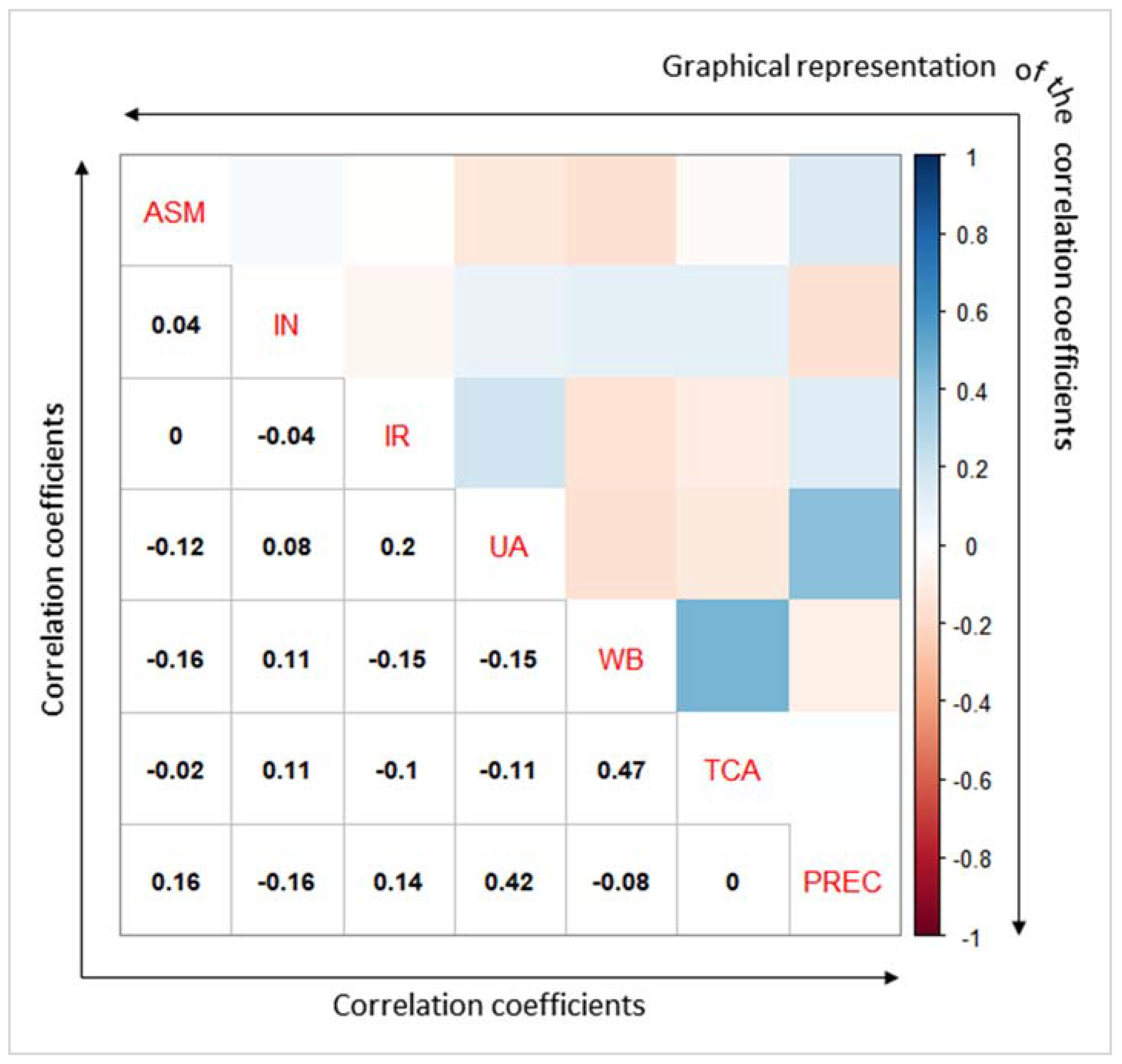
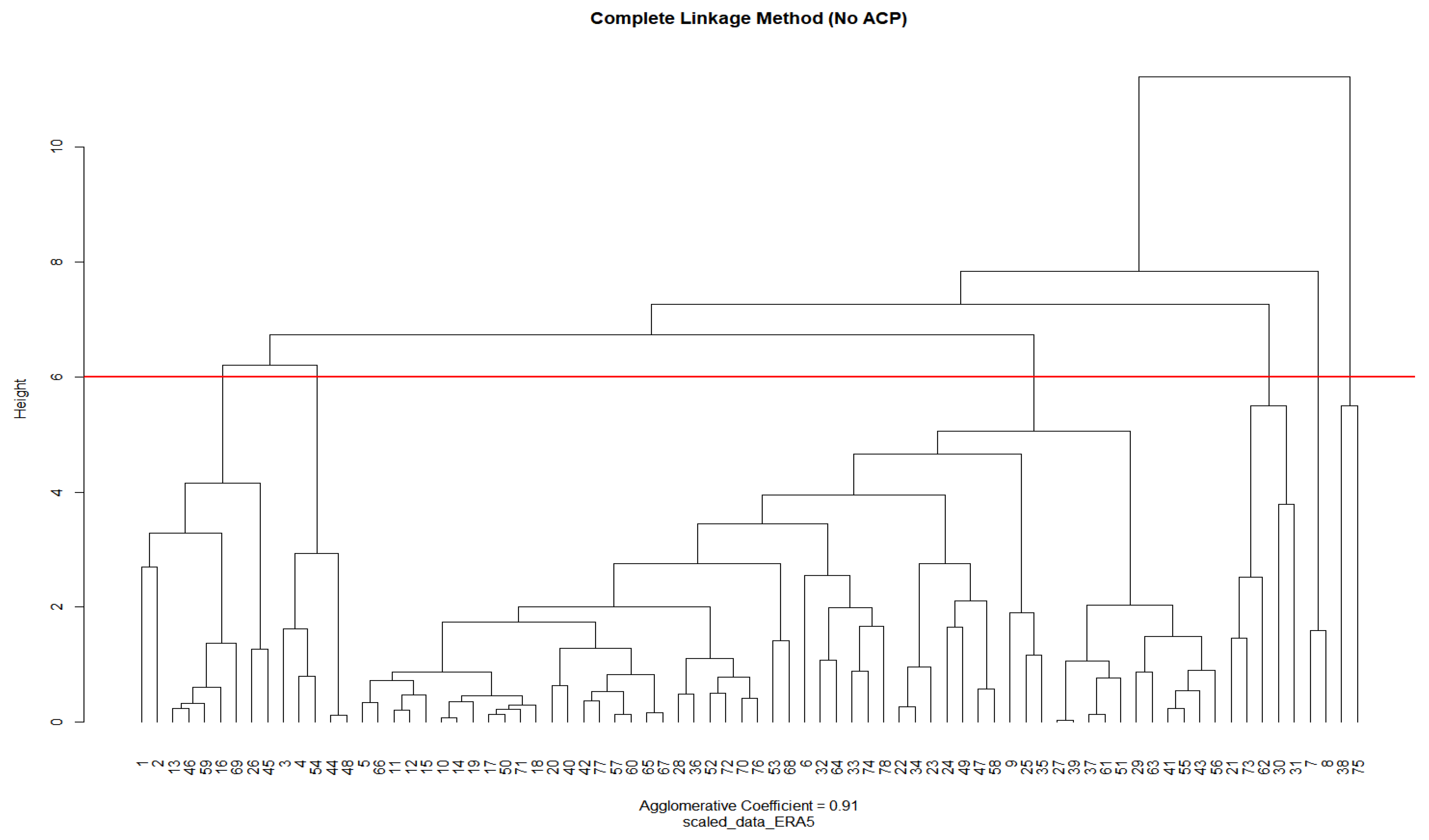
2.3.7. Cluster Analysis
- There are no functional relations between the input parameters.
- There is no pre-cluster information.
- There is no areal cluster information.
3. Results
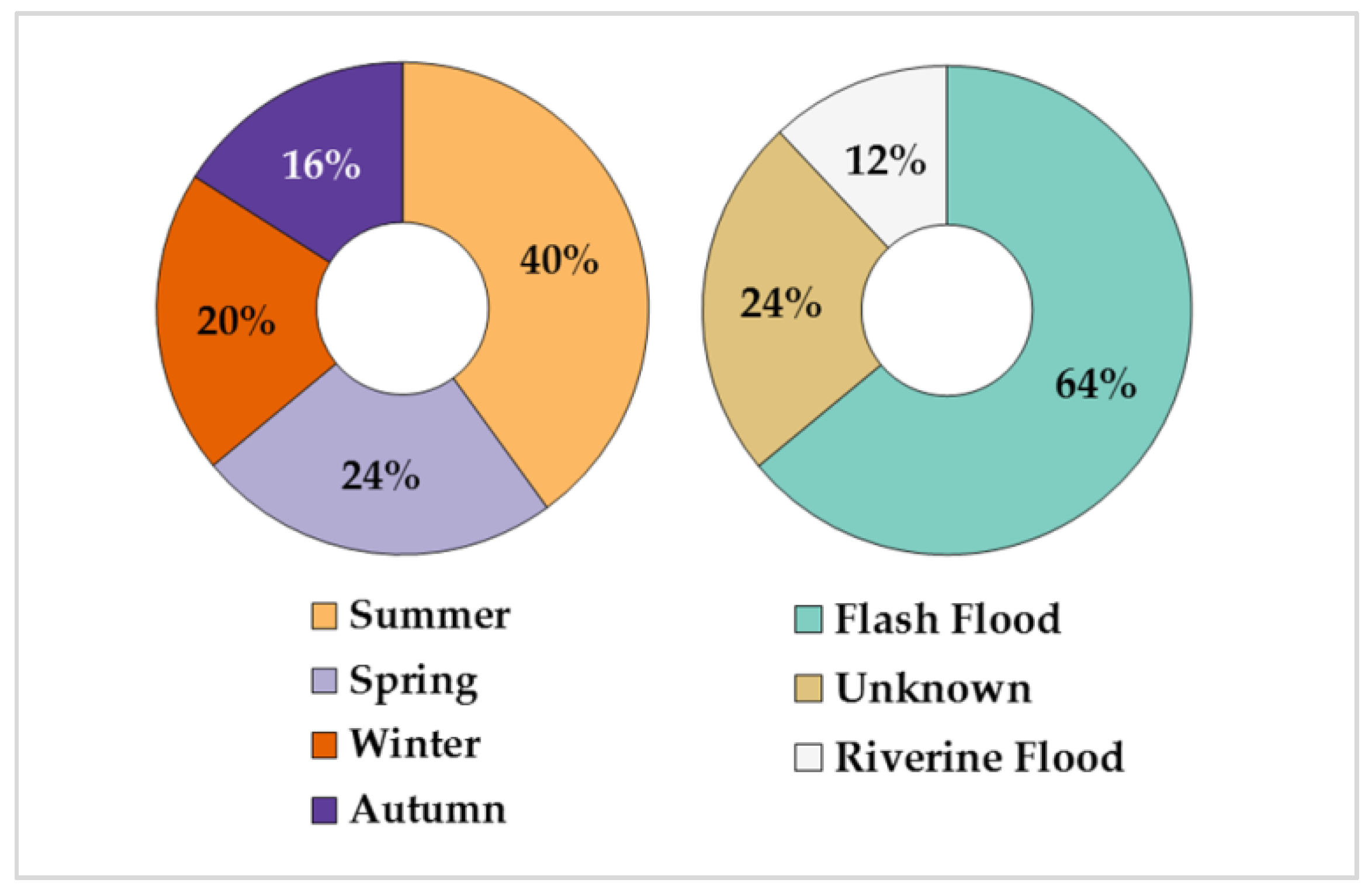
3.1. Flood Types and Atmospheric Circulation Patterns (ACP)
3.2. Antecedent Soil Moisture (ASM) of the Most Severe Flood Events
3.3. Infiltration Number (IN)
3.4. Infiltration Rate (IR)
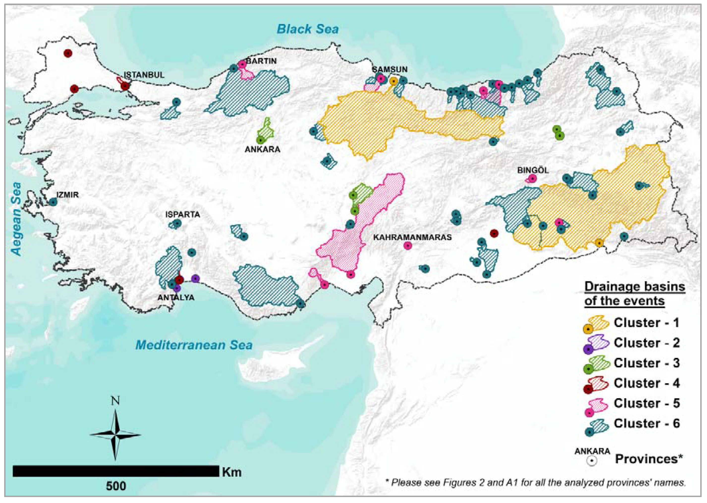
3.5. Cluster Results
- Dry pre-conditions, very low antecedent soil moisture (mean ASM = 0.10%)
- Very low infiltration capacity, very low infiltration rate (IR) (mean IR = 1.61%)
- Very large catchment size (mean TCA = 46,854.60 km2)
- Comparatively high percentage of area with water bodies (mean WB = 4.08%)
- Dry pre-conditions, very low antecedent soil moisture (mean ASM = 0.00%)
- Very high percentage of urbanized area (UA) (mean UA= 86.82%)
- Very small catchment area (TCA) (mean TCA = 6.95 km2)
- Extreme rainfall (mean PREC = 210 mm/day)
- Dry pre-conditions, very low antecedent soil moisture (mean ASM = 0.00%)
- Very high topographic factor, infiltration number (IN) (mean IN = 8.00 km/km2)
- High rainfall intensity (this information was obtained from the related literature (Cluster 3 [66])).
- Dry pre-conditions, low antecedent soil moisture (mean ASM = 4.90%)
- Low topographic factor, infiltration number (IN) (mean IN = 4.43 km/km2)
- Very high infiltration capacity, very high infiltration rate (IR) (mean IR = 64.62%)
- Extreme rainfall (mean PREC = 133.36 mm/day)
- Very high antecedent soil moisture (mean ASM = 92.23%)
- Comparatively low infiltration rate (IR), high runoff (mean IR = 11.89%)
- High rainfall (mean PREC = 86.47 mm/day)
- Spatial distribution over the mountain ranges
4. Discussion
5. Conclusions
- A structured approach to classify floods was designed, using parameters chosen based on their potential triggering and aggravation factors.
- All input variables were obtained and calculated from freely accessible data.
- According to the cluster analysis, six clusters were found based on their dominant flood-producing factors.
- Mapping the clusters also provided the opportunity to interpret the results better in terms of the spatial distribution of the triggering mechanisms and aggravating pathways based on region.
- Orographic rainfall and sudden snow melt were important influencing factors for spring/summer floods in the regions that extend along the Eastern Anatolian Mountain Ranges.
- In central and eastern Anatolia, rapid elevation changes (slope gradient changes) over short distances aggravated the flood events. Geomorphological properties were the relevant factor for floods in these regions.
- The BM (high pressure bridge over Central Europe) circulation pattern type played an important role as a rainfall-producing mechanism, especially for autumn flash floods in Turkey.
- In small catchments, the share of urbanized areas seemed to be an important factor for the flood impacts, with its infiltration attenuation impact. Therefore, planned urbanization in the small catchment is of great importance for flood risk mitigation studies.
- Cluster results can be used as base information; clustering of the dominant flood-producing mechanisms can help hazard classification (source and pathway identification, in particular) in the preliminary risk assessment process.
- However, 25 events are only a small number of case studies and do not represent the entire variety of flood events and their triggering mechanisms. More detailed analyses with more case studies would be a useful next step in understanding the atmospheric circulation pattern impacts on flood events in Turkey. Furthermore, ASM parameter calculations are only based on precipitation and do not reflect the antecedent soil moisture due to underground water table levels or irrigation.
- UA and WB parameters should be calculated based on event day land-use data.
- Additional datasets (such as runoff volume, flood extent, and depth) can be integrated into the cluster analysis. This methodology can be improved with a detailed dataset on event-based calculations and can provide basic information for understanding the triggering mechanisms and aggravating pathways of the flood events.
Author Contributions
Funding
Acknowledgments
Conflicts of Interest
Appendix A


| Event Number | Case ID | Case Number | General Information | Corrected Event Date (Day-Month-Year) | PREC 1 (mm/day) | ACP 2 | ASM 3 (%) | IN 4 (km/km2) | IR 5 (%) | Land Use Information | TCA 9 (km2) | Cluster No. | ||||
|---|---|---|---|---|---|---|---|---|---|---|---|---|---|---|---|---|
| Event Date (Day-Month-Year) | Event Season | Geographic Region | Flood Type | UA 6 (%) (CLC 7 1 **) | WB 8 (%) (CLC 4 ** and 5 **) | |||||||||||
| 1 | FH01_01 | 1 | 27.12.1968 | Winter | Mediterranean | Riverine | 26.12.1968 | 154.30 | NZ | 56.99 | 5.43 | 15.90 | 0.7 | 1.2 | 15,024.10 | 5 |
| FH01_02 | 2 | Mediterranean | 26.12.1968 | 199.50 | NZ | 100 | 4.71 | 6.58 | 1.6 | 0.0 | 458.10 | 5 | ||||
| 2 | FH02_01 | 3 | 30.03.1980 | Spring | Central Anatolia | Flash | 27.03.1980 | 45.20 | SEZ | 0 | 8.01 | 2.76 | 0.8 | 0.0 | 126.00 | 3 |
| FH02_02 | 4 | Central Anatolia | 27.03.1980 | 48.50 | SEZ | 0 | 7.10 | 13.54 | 6.7 | 0.2 | 1561.20 | 3 | ||||
| FH02_03 | 5 | Central Anatolia | 27.03.1980 | 80.60 | SEZ | 0 | 4.07 | 2.54 | 1.2 | 0.0 | 150.40 | 6 | ||||
| 3 | FH03_01 | 6 | 04.11.1995 | Autumn | Aegean | Flash | 04.11.1995 | 108.00 | NZ | 0 | 5.22 | 0.01 | 25.9 | 0.0 | 34.50 | 6 |
| FH03_02 | 7 | Mediterranean | 04.11.1995 | 210.00 | NZ | 0 | 6.01 | 7.49 | 92.5 | 0.0 | 8.70 | 2 | ||||
| FH03_03 | 8 | Mediterranean | 04.11.1995 | 210.00 | NZ | 0 | 4.31 | 14.98 | 81.2 | 0.0 | 5.20 | 2 | ||||
| FH03_04 | 9 | Mediterranean | 04.11.1995 | 40.60 | NZ | 0 | 1.03 | 19.89 | 14.4 | 0.0 | 2.10 | 6 | ||||
| 4 | FH04_01 | 10 | 10.08.1998 | Summer | Black Sea | Flash | 08.08.1998 | 45.50 | WA | 0 | 4.76 | 0.00 | 0.3 | 0.0 | 231.40 | 6 |
| FH04_02 | 11 | Black Sea | 08.08.1998 | 45.50 | WA | 0 | 4.14 | 0.72 | 0.4 | 0.1 | 1063.80 | 6 | ||||
| FH04_03 | 12 | Black Sea | 08.08.1998 | 45.50 | WA | 0 | 4.33 | 0.00 | 0.1 | 0.3 | 1064.50 | 6 | ||||
| 5 | FH05_01 | 13 | 18.06.1990 | Summer | Black Sea | Flash | 20.06.1990 | 64.80 | SWZ | 100 | 4.14 | 0.72 | 0.4 | 0.1 | 1063.80 | 5 |
| FH05_02 | 14 | Black Sea | 19.06.1990 | 43.00 | SWZ | 0 | 4.74 | 0.73 | 0.6 | 0.0 | 19.50 | 6 | ||||
| FH05_03 | 15 | Black Sea | 19.06.1990 | 58.30 | SWZ | 8.2 | 4.19 | 0.26 | 0.3 | 0.3 | 3155.60 | 6 | ||||
| FH05_04 | 16 | Black Sea | 19.06.1990 | 43.00 | SWZ | 93.4 | 4.51 | 0.00 | 0.2 | 0.0 | 113.40 | 5 | ||||
| FH05_05 | 17 | Black Sea | 19.06.1990 | 58.30 | SWZ | 0 | 4.65 | 0.00 | 0.0 | 0.1 | 535.30 | 6 | ||||
| FH05_06 | 18 | Black Sea | 19.06.1990 | 58.30 | SWZ | 0 | 4.58 | 0.00 | 0.4 | 0.3 | 801.00 | 6 | ||||
| FH05_07 | 19 | Black Sea | 19.06.1990 | 58.30 | SWZ | 0 | 5.02 | 0.00 | 0.5 | 0.0 | 105.70 | 6 | ||||
| 6 | FH06_01 | 20 | 27.10.2006 | Autumn | Southeastern Anatolia | Flash | 27.10.2006 | 35.90 | SWZ | 0 | 4.24 | 16.57 | 10.8 | 0.0 | 111.00 | 6 |
| FH06_03 | 21 | Southeastern Anatolia | 28.10.2006 | 64.00 | BM | 0 | 5.71 | 75.32 | 24.0 | 0.0 | 8.20 | 4 | ||||
| FH06_05 | 22 | Southeastern Anatolia | 28.10.2006 | 52.00 | BM | 0 | 5.17 | 64.47 | 1.3 | 0.0 | 181.20 | 6 | ||||
| FH06_06 | 23 | Southeastern Anatolia | 28.10.2006 | 52.00 | BM | 0 | 5.80 | 51.88 | 0.9 | 0.2 | 1736.90 | 6 | ||||
| FH06_07 | 24 | Southeastern Anatolia | 29.10.2006 | 51.00 | BM | 34.1 | 5.99 | 33.35 | 2.5 | 0.7 | 4150.20 | 6 | ||||
| FH06_08 | 25 | Southeastern Anatolia | 29.10.2006 | 29.80 | BM | 0 | 2.54 | 0.00 | 0.0 | 0.0 | 18.80 | 6 | ||||
| FH06_10 | 26 | Southeastern Anatolia | 29.10.2006 | 37.60 | BM | 79.7 | 6.68 | 36.71 | 5.4 | 0.0 | 310.70 | 5 | ||||
| 7 | FH07_01 | 27 | 16.05.1991 | Spring | Eastern Anatolia | Flash | 16.05.1991 | 28.70 | TRM | 0 | 5.54 | 22.82 | 1.6 | 2.9 | 6232.00 | 6 |
| FH07_02 | 28 | Eastern Anatolia | 16.05.1991 | 18.20 | TRM | 0 | 6.15 | 0.00 | 0.0 | 0.0 | 18.40 | 6 | ||||
| FH07_03 | 29 | Eastern Anatolia | 16.05.1991 | 28.20 | TRM | 0 | 4.43 | 2.18 | 0.0 | 4.2 | 282.30 | 6 | ||||
| 8 | FH08_01 | 30 | 07.09.2009 | Autumn | Marmara | Flash | 09.09.2009 | 248.00 | BM | 0 | 5.63 | 19.26 | 20.8 | 3.1 | 163.90 | 4 |
| FH08_02 | 31 | Marmara | 09.09.2009 | 248.00 | BM | 0 | 3.61 | 73.47 | 13.1 | 0.0 | 37.20 | 4 | ||||
| 9 | FH09_01 | 32 | 23.07.2002 | Summer | Black Sea | Flash | 23.07.2002 | 154.80 | WZ | 0 | 4.98 | 1.80 | 0.0 | 2.4 | 329.20 | 6 |
| FH09_02 | 33 | Black Sea | 23.07.2002 | 154.80 | WZ | 0 | 4.44 | 0.00 | 0.2 | 1.1 | 205.70 | 6 | ||||
| FH09_03 | 34 | Central Anatolia | 23.07.2002 | 64.30 | WZ | 0 | 5.03 | 65.72 | 1.3 | 0.0 | 844.50 | 6 | ||||
| FH09_04 | 35 | Central Anatolia | 23.07.2002 | 64.30 | WZ | 0 | 3.11 | 17.33 | 2.1 | 0.1 | 633.70 | 6 | ||||
| FH09_05 | 36 | Eastern Anatolia | 24.07.2002 | 22.80 | WZ | 0 | 6.10 | 6.00 | 2.1 | 0.3 | 2334.70 | 6 | ||||
| FH09_06 | 37 | Eastern Anatolia | 24.07.2002 | 12.50 | WZ | 0 | 5.63 | 9.19 | 1.4 | 2.3 | 2267.10 | 6 | ||||
| 10 | FH10_01 | 38 | 19.11.1974 | Autumn | Southeastern Anatolia | NA | 19.11.1974 | 40.70 | SWZ | 0 | 5.89 | 1.41 | 1.0 | 7.5 | 57,593.40 | 1 |
| 11 | FH11_01 | 39 | 12.06.1998 | Summer | Southeastern Anatolia | Flash | 13.06.1998 | 26.80 | TRM | 0 | 5.54 | 22.93 | 1.6 | 2.9 | 6232.00 | 6 |
| FH11_02 | 40 | Southeastern Anatolia | 12.06.1998 | 0.60 | TRM | 0 | 4.24 | 16.57 | 10.8 | 0.0 | 111.00 | 6 | ||||
| FH11_03 | 41 | Eastern Anatolia | 12.06.1998 | 21.50 | TRM | 0 | 5.36 | 6.54 | 0.9 | 3.7 | 519.70 | 6 | ||||
| FH11_04 | 42 | Eastern Anatolia | 12.06.1998 | 8.80 | TRM | 0 | 5.12 | 1.85 | 4.1 | 0.0 | 165.80 | 6 | ||||
| FH11_05 | 43 | Eastern Anatolia | 13.06.1998 | 12.62 | TRM | 0 | 5.86 | 2.35 | 1.0 | 4.0 | 2195.70 | 6 | ||||
| FH11_06 | 44 | Eastern Anatolia | 13.06.1998 | 7.48 | TRM | 0 | 9.33 | 0.00 | 21.4 | 0.0 | 14.80 | 3 | ||||
| 12 | FH12_01 | 45 | 18.02.1990 | Winter | Eastern Anatolia | Flash | 18.02.1990 | 44.50 | SWA | 100 | 7.96 | 40.40 | 1.5 | 0.0 | 10.70 | 5 |
| FH12_02 | 46 | Eastern Anatolia | 18.02.1990 | 72.90 | SWA | 100 | 4.30 | 0.35 | 0.1 | 0.0 | 108.60 | 5 | ||||
| FH12_03 | 47 | Southeastern Anatolia | 14.02.1990 | 37.20 | SWA | 0 | 5.57 | 24.12 | 23.0 | 0.3 | 124.80 | 6 | ||||
| 13 | FH13_01 | 48 | 05.03.2004 | Spring | Eastern Anatolia | Riverine | 05.03.2004 | 14.20 | BM | 0 | 9.33 | 0.00 | 21.4 | 0.0 | 14.80 | 3 |
| FH13_02 | 49 | Southeastern Anatolia | 06.03.2004 | 8.20 | BM | 0 | 6.68 | 36.71 | 5.4 | 0.0 | 310.70 | 6 | ||||
| FH13_03 | 50 | Eastern Anatolia | 06.03.2004 | 62.80 | BM | 0 | 4.70 | 0.00 | 0.5 | 0.0 | 47.30 | 6 | ||||
| FH13_04 | 51 | Eastern Anatolia | 06.03.2004 | 54.70 | BM | 0 | 5.80 | 9.32 | 1.4 | 2.3 | 2234.40 | 6 | ||||
| FH13_05 | 52 | Central Anatolia | 05.03.2004 | 18.20 | BM | 0 | 5.42 | 4.96 | 0.6 | 0.5 | 623.60 | 6 | ||||
| FH13_06 | 53 | Mediterranean | 05.03.2004 | 26.20 | BM | 0 | 5.41 | 3.28 | 0.3 | 0.6 | 10,731.60 | 6 | ||||
| 14 | FH14_01 | 54 | 13.06.1988 | Summer | Central Anatolia | Flash | 12.06.1988 | 71.30 | HB | 0 | 6.25 | 12.52 | 7.4 | 0.2 | 1082.70 | 3 |
| 15 | FH15_01 | 55 | 27.05.2007 | Spring | Eastern Anatolia | Flash | 27.05.2007 | 8.60 | TRW | 0 | 5.40 | 6.58 | 0.6 | 3.7 | 516.70 | 6 |
| FH15_02 | 56 | Eastern Anatolia | 27.05.2007 | 3.30 | TRW | 0 | 5.49 | 0.64 | 3.4 | 4.8 | 163.80 | 6 | ||||
| FH15_03 | 57 | Eastern Anatolia | 27.05.2007 | 1.20 | TRW | 0 | 4.70 | 0.00 | 0.5 | 0.0 | 47.30 | 6 | ||||
| FH15_04 | 58 | Southeastern Anatolia | 27.05.2007 | 5.60 | TRW | 0 | 5.57 | 24.12 | 23.0 | 0.3 | 124.80 | 6 | ||||
| 16 | FH16_01 | 59 | 03.07.2012 | Summer | Black Sea | Riverine | 04.07.2012 | 68.40 | TRW | 100 | 4.50 | 2.77 | 1.4 | 0.1 | 817.50 | 5 |
| 17 | FH17_01 | 60 | 01.07.2006 | Summer | Eastern Anatolia | NA | 03.07.2006 | 8.30 | SEA | 0 | 4.70 | 0.00 | 0.5 | 0.0 | 47.30 | 6 |
| FH17_02 | 61 | Eastern Anatolia | 04.07.2006 | 12.50 | SEA | 0 | 5.80 | 9.32 | 1.4 | 2.3 | 2234.40 | 6 | ||||
| FH17_03 | 62 | Marmara | 03.07.2006 | 74.90 | SEA | 0 | 2.72 | 85.14 | 14.4 | 0.0 | 7.90 | 4 | ||||
| FH17_04 | 63 | Black Sea | 06.07.2006 | 26.30 | TRW | 0 | 4.50 | 10.64 | 4.6 | 3.2 | 179.60 | 6 | ||||
| FH17_05 | 64 | Black Sea | 02.07.2006 | 95.20 | SEA | 0 | 4.98 | 1.80 | 0.0 | 2.4 | 329.20 | 6 | ||||
| FH17_06 | 65 | Black Sea | 02.07.2006 | 9.20 | SEA | 0 | 4.15 | 3.43 | 1.2 | 0.0 | 331.70 | 6 | ||||
| FH17_07 | 66 | Black Sea | 02.07.2006 | 77.30 | SEA | 0 | 4.46 | 0.52 | 0.3 | 0.0 | 166.70 | 6 | ||||
| 18 | FH18_01 | 67 | 17.12.1981 | Winter | Black Sea | NA | 16.12.1981 | 18.30 | WS | 0 | 4.15 | 3.43 | 1.2 | 0.0 | 331.70 | 6 |
| 19 | FH19_01 | 68 | 20.05.1998 | Spring | Black Sea | Flash | 20.05.1998 | 73.00 | NWZ | 32.4 | 5.39 | 0.00 | 1.2 | 0.4 | 13,315.60 | 6 |
| FH19_03 | 69 | Black Sea | 21.05.1998 | 93.20 | NWZ | 100 | 5.43 | 3.54 | 1.3 | 0.9 | 652.70 | 5 | ||||
| FH19_04 | 70 | Black Sea | 20.05.1998 | 59.90 | NWZ | 0 | 5.41 | 5.57 | 3.3 | 0.6 | 913.70 | 6 | ||||
| 20 | FH20_01 | 71 | 20.06.2002 | Summer | Black Sea | Flash | 20.06.2002 | 57.80 | SWA | 0 | 4.46 | 0.52 | 0.3 | 0.0 | 166.70 | 6 |
| 21 | FH21_01 | 72 | 13.07.1995 | Summer | Mediterranean | NA | 14.07.1995 | 28.20 | HNFA | 0 | 4.96 | 0.00 | 1.0 | 0.3 | 306.10 | 6 |
| 22 | FH22_01 | 73 | 15.12.1997 | Winter | Mediterranean | Flash | 15.12.1997 | 31.90 | SEZ | 24.5 | 4.50 | 69.92 | 29.8 | 0.0 | 65.30 | 4 |
| 23 | FH23_01 | 74 | 20.07.2009 | Summer | Black Sea | Flash | 21.07.2009 | 132.20 | SWZ | 0 | 4.46 | 0.52 | 0.3 | 0.0 | 166.70 | 6 |
| 24 | FH24_01 | 75 | 27.05.2000 | Spring | Black Sea | NA | 27.05.2000 | 79.00 | WZ | 0.2 | 5.66 | 1.80 | 1.0 | 0.7 | 36,115.80 | 1 |
| FH24_03 | 76 | Black Sea | 27.05.2000 | 40.70 | WZ | 0 | 5.26 | 6.14 | 0.9 | 0.5 | 546.10 | 6 | ||||
| FH24_04 | 77 | Black Sea | 26.05.2000 | 17.60 | WZ | 0 | 4.79 | 0.11 | 7.1 | 0.0 | 64.40 | 6 | ||||
| 25 | FH25_01 | 78 | 24.12.2003 | Winter | Mediterranean | NA | 24.12.2003 | 105.40 | BM | 0 | 5.55 | 16.10 | 1.4 | 0.2 | 3847.00 | 6 |
| Hydrologic Soil Group | Major Soil Group (BTG) * | Land Use and Mapping Unit Symbols |
|---|---|---|
| A (Low runoff potential) (min. infiltration rate = 7.5–10.0 mm/h) | L | 1–11, 13–15, 17–19, 21, 22 |
| A | 3, 6, 9, 10 | |
| E, T | 17–24 | |
| O | Soil groups that contain one of the symbols m, p r and h, s, a, k v | |
| KK, ST–IY | - | |
| B (Medium runoff potential) (min. infiltration rate = 3.0–7.5 mm/h) | P, G | 1, 2, 5, 6, 9, 10 |
| C, D, M, N | 1–10, with symbol a | |
| E, T | 1–16 | |
| B, F, R, Y | 1–8 | |
| U | 1, 2, 3 | |
| L | 12, 16, 20, 24 | |
| X | 1, 2, 3, 4 | |
| K | 4, 5, 6, 13, 14, 15, 22, 23, 24 | |
| A | 3, 6, 9, 10 with the symbols h, s, a, k, v | |
| C (High runoff potential) (min. infiltration rate = 0.8–3.0 mm/h) | P, G | 3, 4, 7, 8, from 11–22 |
| C, D, M, N | 11–18 | |
| B, F | 9–23 | |
| U | 4–21 | |
| R | 9–21 | |
| L, E, T | 25 | |
| Y | 9–25 | |
| X | 5–20 | |
| K | 1, 2, 3, 10, 11, 12, 19, 20, 21, 28, 29, 30, 31, 32 | |
| Ç | 3, 6, 9 | |
| A | 2, 5, 8 with the symbols h, s, a, k, v | |
| D (Very high runoff potential) (min. infiltration rate = 0.0–0.8 mm/h) | P, G | 23, 24, 25 |
| C, D, M, N | 19–25 | |
| B, F | 24, 25 | |
| R, U | 22–25 | |
| V | 1–25 | |
| Z | 1–4 | |
| A | 1, 4, 7 with the symbols h, s, a, k, v, y | |
| H | H with the symbols h, s, a, k, v | |
| S | S with the symbols h, s, a, k, v | |
| X | 21, 22, 23, 24, 25 | |
| Ç | 1, 2, 4, 5, 7, 8 | |
| L | SB, ÇK |
| Symbol | Major Soil Groups | Symbol | Major Soil Groups | Symbol | Soil Type | Symbol | Slope-Depth Combination | Symbol | Slope-Depth Combination |
|---|---|---|---|---|---|---|---|---|---|
| P | Red Yellow Podzol Soils | X | Basaltic Soils | h | Brackish | 1 | Very deep (90+ m)/Slope %0–2 | 16 | Very shallow (20–0 m)/Slope %12–20 |
| G | Grey Brown Podzol Soils | Y | Upland Soils | s | Saline | 2 | Deep (90–50 m)/Slope %0–2 | 17 | Very deep (90+ m)/Slope %20–30 |
| M | Brown Forest Soils | A | Alluvial Soils | a | Alkali | 3 | Shallow (50–20 m)/Slope %0–2 | 18 | Deep (90–50 m)/Slope %20–30 |
| N | Non-Calcareous Brown Forest Soils | H | Gleysol | k | Brackish–Alkali | 4 | Very shallow (20–0 m)/Slope %0–2 | 19 | Shallow (50–20 m)/Slope %20–30 |
| CE | Chestnut Soil | S | Alluvial Coastal Soils | v | Saline–Alkali | 5 | Very deep (90+ m)/Slope %2–6 | 20 | Very shallow (20–0 m)/Slope %20–30 |
| D | Reddish Chestnut Soil | K | Colluvial Soils | t | Stony | 6 | Deep (90–50 m)/Slope %2–6 | 21 | Very deep (90+ m)/Slope %30+ |
| T | Red Mediterranean Soils | C | Saline-Alkali Soil | r | Rocky | 7 | Shallow (50–20 m)/Slope %2–6 | 22 | Deep (90–50 m)/Slope %30+ |
| E | Red Brown Mediterranean Soils | O | Organic Soils | y | Poor drainage | 8 | Very shallow (20–0 m)/Slope %2–6 | 23 | Shallow (50–20 m)/Slope %30+ |
| B | Brown Soils | f | Very poor drainage | 9 | Very deep (90+ m)/Slope %6–12 | 24 | Very shallow (20–0 m)/Slope %30+ | ||
| U | Non-Calcareous Brown Soils | CK | Bare rocks and boulders | 10 | Deep (90–50 m)/Slope %6–12 | 25 | Lithosolic | ||
| F | Reddish Brown Soils | IY | River flood plains | 11 | Shallow (50–20 m)/Slope %6–12 | 26 | Lithosolic | ||
| R | Rendzina | SK | Coastal Sand Dunes | 12 | Very shallow (20–0 m)/Slope %6–12 | 27 | Lithosolic | ||
| V | Vertisol Soil | KK | Ground Sand Dunes | 13 | Very deep (90+ m)/Slope %12–20 | 28 | Lithosolic | ||
| Z | Sierozem | SB | Marshes | 14 | Deep (90–50 m)/Slope %12–20 | 29 | Lithosolic | ||
| L | Regosol | DK | Permanent snow-cover | 15 | Shallow (50–20 m)/Slope %12–20 | 30 | Lithosolic |

References
- Koç, G.; Thieken, A.H. The relevance of flood hazards and impacts in Turkey: What can be learned from different disaster loss databases? Nat. Hazards 2018, 91, 375–408. [Google Scholar] [CrossRef]
- Kadıoğlu, M. Türkiye’de iklim degisikligi risk yonetimi (Climate change risk management in Turkey). In Turkiye’nin Iklim Degisikligi II. Ulusal Bildiriminin Hazirlanmasi Projesi Yayini; T.C. Çevre ve Şehircilik Bakanlığı: Ankara, Turkey, 2012; p. 172. Available online: http://www.undp.org/content/dam/turkey/docs/projectdocuments/EnvSust/UNDP-TR-Iklim_Degisikligi_Risk_Yonetimi.pdf (accessed on 29 May 2020).
- Nied, M.; Pardowitz, T.; Nissen, K.; Ulbrich, U.; Hundecha, Y.; Merz, B. On the relationship between hydro-meteorological patterns and flood types. J. Hydrol. 2014, 519, 3249–3262. [Google Scholar] [CrossRef]
- Turkington, T.; Breinl, K.; Ettema, J.; Alkema, D.; Jetten, V. A new flood type classification method for use in climate change impact studies. Weather Clim. Extrem. 2016, 14, 1–16. [Google Scholar] [CrossRef]
- Prudhomme, C.; Crooks, S.; Kay, A.L.; Reynard, N. Climate change and river flooding: Part 1 classifying the sensitivity of British catchments. Clim. Chang. 2013, 119, 933–948. [Google Scholar] [CrossRef]
- Schröter, K.; Kunz, M.; Elmer, F.; Mühr, B.; Merz, B. What made the June 2013 flood in Germany an exceptional event? A hydro-meteorological evaluation. Hydrol. Earth Syst. Sci. 2015, 19, 309–327. [Google Scholar] [CrossRef]
- Merz, R.; Blöschl, G. A Process Typology of Regional Floods. Water Resour. Res. 2003, 39. [Google Scholar] [CrossRef]
- Beurton, S.; Thieken, A.H. Seasonality of Floods in Germany. Hydrol. Sci. J. 2009, 54, 62–76. [Google Scholar] [CrossRef]
- Baltaci, H.; Göktürk, O.M.; Kindap, T.; Ünal, A.; Karaca, M. Atmospheric circulation types in Marmara Region (NW Turkey) and their influence on precipitation. Int. J. Climatol. 2015, 35, 1810–1820. [Google Scholar] [CrossRef]
- Baltaci, H. Meteorological analysis of flash floods in Artvin (NE Turkey) on August 24, 2015. Nat. Hazards Earth Syst. Sci. Discuss. 2017, 1–23. [Google Scholar] [CrossRef]
- Kömüşcü, A.Ü.; Çelik, S. Analysis of the Marmara flood in Turkey, 7-10 September 2009: An assessment from hydrometeorological perspective. Nat. Hazards 2013, 66, 781–808. [Google Scholar] [CrossRef]
- Türkeş, M.; Tatli, H. Use of the spectral clustering to determine coherent precipitation regions in Turkey for the period 1929-2007. Int. J. Clim. 2010, 31, 2055–2067. [Google Scholar] [CrossRef]
- Lolis, C.J.; Türkeş, M. Atmospheric circulation characteristics favouring extreme precipitation in Turkey. Clim. Res. 2016, 71, 139–153. [Google Scholar] [CrossRef]
- Sariş, F.; Hannah, D.M.; Eastwood, W.J. Spatial variability of precipitation regimes over Turkey. Hydrol. Sci. J. 2010, 55, 234–249. [Google Scholar] [CrossRef]
- Merz, B.; Apel, H.; Dung, N.V.; Falter, D.; Hundecha, Y.; Kreibich, H.; Schröter, K.; Vorogushyn, S. Large-scale flood risk assessment using a coupled model chain. In Proceedings of the E3S Web of Conferences, Swieradow-Zdroj, Poland, 25–28 September 2016; EDP Sciences: Les Ulis, France, 2016; Volume 7, p. 11005. [Google Scholar] [CrossRef]
- Thieken, A.H.; Apel, H.; Merz, B. Assessing the probability of large-scale flood loss events: A case study for the river Rhine, Germany. J. Flood Risk Manag. 2014, 8, 247–262. [Google Scholar] [CrossRef]
- Sivapalan, M. Process complexity at hillslope scale, process simplicity at the watershed scale: Is there a connection? Hydrol. Process. 2003, 17, 1037–1041. [Google Scholar] [CrossRef]
- Merz, B.; Aerts, J.; Arnbjerg-Nielsen, K.; Baldi, M.; Becker, A.; Bichet, A.; Bloschl, G.; Bouwer, L.M.; Brauer, A.; Cioffi, F.; et al. Floods and climate: Emerging perspectives for flood risk assessment and management. Nat. Hazards Earth Syst. Sci. 2014, 14, 1921–1942. [Google Scholar] [CrossRef]
- Zscheischler, J.; Westra, S.; Hurk, B.V.D.; Seneviratne, S.I.; Ward, P.J.; Pitman, A.; AghaKouchak, A.; Bresch, D.N.; Leonard, M.; Wahl, T.; et al. Future climate risk from compound events. Nat. Clim. Chang. 2018, 8, 469–477. [Google Scholar] [CrossRef]
- Hammer, C.L.; Kostroch, D.C.; Quirós, G.S.T.A. Internal Group. What challenges come with big data? In Big Data: Potential, Challenges and Statistical Implications, 1st ed.; International Monetary Fund: Washington, DC, USA, 2017; pp. 20–23. ISBN 9781484310908. [Google Scholar]
- Kandilioti, G.; Makropoulos, C. Preliminary flood risk assessment: The case of Athens. Nat. Hazards 2011, 61, 441–468. [Google Scholar] [CrossRef]
- Sayers, P.B.; Hall, J.W.; Meadowcroft, I.C. Towards risk-based flood hazard management in the UK. Proc. Inst. Civ. Eng. Civ. Eng. 2002, 150, 36–42. [Google Scholar] [CrossRef]
- Tarasova, L.; Merz, R.; Kiss, A.; Basso, S.; Blöschl, G.; Merz, B.; Viglione, A.; Plötner, S.; Guse, B.; Schumann, A.; et al. Causative classification of river flood events. Wiley Interdiscip. Rev. Water 2019, 6, e1353. [Google Scholar] [CrossRef]
- Meteoroloji Genel Müdürlügü (Turkish State Meteorological Service). Available online: https://www.mgm.gov.tr/ (accessed on 15 May 2020).
- Meteoroloji Genel Müdürlügü, Meteoroloji Tarihi (History of Meteorology). Available online: https://mgm.gov.tr/genel/meteorolojitarihi.aspx (accessed on 26 September 2019).
- Meteoroloji Genel Müdürlügü, About TSMS. Available online: https://www.mgm.gov.tr/eng/about.aspx. (accessed on 6 May 2019).
- Meteoroloji Genel Müdürlügü, Meteorological Data Information Sales and Presentation System (MEVBIS). Available online: https://mevbis.mgm.gov.tr/mevbis/ui/index.html#/Workspace (accessed on 6 May 2019).
- Meteoroloji Genel Müdürlügü, İstasyon Bilgileri Veritabanı (Station Database Information). Available online: https://www.mgm.gov.tr/kurumsal/istasyonlarimiz.aspx?sSirala=LT&m=ZONGULDAK#sfB (accessed on 7 May 2019).
- ECMWF—European Centre for Medium-Range Weather Forecasts ERA5. Available online: https://cds.climate.copernicus.eu/cdsapp#!/dataset/reanalysis-era5-single-levels?tab=overview (accessed on 4 October 2019).
- Bárdossy, A.; Filiz, F. Identification of flood producing atmospheric circulation patterns. J. Hydrol. 2005, 313, 48–57. [Google Scholar] [CrossRef]
- Huth, R.; Beck, C.; Philipp, A.; Demuzere, M.; Ustrnul, Z.; Cahynová, M.; Kyselý, J.; Tveito, O.E. Classifications of Atmospheric Circulation Patterns. Ann. New York Acad. Sci. 2008, 1146, 105–152. [Google Scholar] [CrossRef] [PubMed]
- Bárdossy, A. Atmospheric circulation pattern classification for South-West Germany using hydrological variables. Phys. Chem. Earth, Parts A/B/C 2010, 35, 498–506. [Google Scholar] [CrossRef]
- Littmann, T. An empirical classification of weather types in the Mediterranean Basin and their interrelation with rainfall. Theor. Appl. Clim. 2000, 66, 161–171. [Google Scholar] [CrossRef]
- James, P.M. An objective classification method for Hess and Brezowsky Grosswetterlagen over Europe. Theor. Appl. Clim. 2006, 88, 17–42. [Google Scholar] [CrossRef]
- Schwander, M.; Brönnimann, S.; Delaygue, G.; Rohrer, M.; Auchmann, R.; Brugnara, Y. Reconstruction of Central European daily weather types back to 1763. Int. J. Clim. 2017, 37, 30–44. [Google Scholar] [CrossRef]
- Kučerová, M.; Beck, C.; Philipp, A.; Huth, R. Trends in frequency and persistence of atmospheric circulation types over Europe derived from a multitude of classifications. Int. J. Clim. 2016, 37, 2502–2521. [Google Scholar] [CrossRef]
- Baur, F.; Hess, P.; Nagel, H. Kalender der Grosswetterlagen Europas 1881–1939; Forschungsinstitut für langfristige Witterungsvorhersage: Bad Homburg, Germany, 1944; 35 p. [Google Scholar]
- Hess, P.; Brezowsky, H. Katalog der Grosswetterlagen Mitteleuropas. Berichte des Dtsch. Wetterdienstes US-Zone 33; Deutscher Wetterdienst: Bad Kissingen, Germany, 1952. [Google Scholar]
- Hess, P.; Brezowsky, H. Katalog der Grosswetterlagen Mitteleuropas—2. Neu Bearb. U. Erg. Aufl. Berichte des Dtsch. Wetterdienstes; Deutscher Wetterdienst: Bad Kissingen, Germany, 1969; Volume 15. [Google Scholar]
- Hess, P.; Brezowsky, H. Katalog der Grosswetterlagen Europas 1881–1976/3. verbesserte und ergänzte Aufl. Berichte des Dtsch. Wetterdienstes; Deutscher Wetterdienst: Bad Kissingen, Germany, 1977; Volume 15. [Google Scholar]
- Werner, P.C.; Gerstengarbe, F.W. Katalog der Grosswetterlagen Europas (1881–2009): Nach Paul Hess und Helmut Brezowsky. Potsdam Institute for Climate Impact Research—PIK Report; Potsdam Institut für Klimafolgenforschung: Potsdam, Germany, 2010. [Google Scholar]
- Petrow, T.; Zimmer, J.; Merz, B. Changes in the flood hazard in Germany through changing frequency and persistence of circulation patterns. Nat. Hazards Earth Syst. Sci. 2009, 9, 1409–1423. [Google Scholar] [CrossRef]
- CGIAR-CSI. Available online: https://cgiarcsi.community/about/ (accessed on 23 May 2019).
- SRTM. Available online: http://srtm.csi.cgiar.org/ (accessed on 23 May 2019).
- Tanrikulu, M. Türkiye’de Toprak Etüt-Haritalama Çalişmalari ve Harvey Oakes (Soil Survey-Mapping Studies in Turkey and Harvey Oakes). Akad. Bakis Derg. 2017, 64, 664–678. [Google Scholar]
- EEA—European Environment Agency. CORINE Land Cover—Methodology; EU Publications: Luxembourg City, Luxembourg, 1995; pp. 1–163. ISBN 92-826-2579-6. [Google Scholar]
- Copernicus—Corine Land Cover. Available online: https://land.copernicus.eu/pan-european/corine-land-cover (accessed on 31 May 2019).
- Nied, M.; Hundecha, Y.; Merz, B. Flood-initiating catchment conditions: A spatio-temporal analysis of large-scale soil moisture patterns in the Elbe River basin. Hydrol. Earth Syst. Sci. 2013, 17, 1401–1414. [Google Scholar] [CrossRef]
- Brocca, L.; Melone, F.; Moramarco, T.; Morbidelli, R. Antecedent wetness conditions based on ERS scatterometer data. J. Hydrol. 2009, 364, 73–87. [Google Scholar] [CrossRef]
- Özer, Z. Su Yapılarının Projelendirilmesinde Hidrolojik ve Hidrolik Esaslar-Teknik Rehber. In Hydrological and Hydraulic Principles in Designing Water Structures-Technical Guide, 1st ed.; Ankara Köy Hizmetleri Genel Müdürlüğü Yayınları: Ankara, Turkey, 1990; p. 714. [Google Scholar]
- Masoudian, M.; Theobald, S. Influence of land surface topography on flood hydrograph. J. Am. Sci. 2011, 7, 354–361. [Google Scholar] [CrossRef]
- Rama, V.A. Drainage basin analysis for characterization of 3rd order watersheds using Geographic Information System (GIS) and ASTER data. J. Geomat. 2014, 8, 200–210. [Google Scholar]
- Candan, O.; Akal, C.; Koralay, E.; Okay, A.I.; Oberhänsli, R.; Prelević, D.; Mertz-Kraus, R. Carboniferous granites on the northern margin of Gondwana, Anatolide-Tauride Block, Turkey—Evidence for southward subduction of Paleotethys. Tectonophys. 2016, 683, 349–366. [Google Scholar] [CrossRef]
- Faniran, A. The index of drainage intensity—A provisional new drainage factor. Aust. J. Sci. 1968, 31, 328–330. [Google Scholar]
- Horton, R.H. Erosional development of streams and their drainage basins; hydrophysical approach to quantitative morphology. Geol. Soc. Am. Bull. 1945, 56, 275–370. [Google Scholar] [CrossRef]
- Prachansri, S. Analysis of Soil and Land Cover Parameters for Flood Hazard Assessment: A Case Study of the Nam Chun Watershed, Phetchabun, Thailand. Master’s Thesis, International Institute for Geo-Information Science and Earth Observation, Enschede, The Netherlands, March 2007. [Google Scholar]
- Rogger, M.; Agnoletti, M.; Alaoui, A.; Bathurst, J.C.; Bodner, G.; Borga, M.; Chaplot, V.; Gallart, F.; Glatzel, G.; Hall, J.; et al. Land use change impacts on floods at the catchment scale: Challenges and opportunities for future research. Water Resour. Res. 2017, 53, 5209–5219. [Google Scholar] [CrossRef]
- Yim, O.; Ramdeen, K.T. Hierarchical Cluster Analysis: Comparison of Three Linkage Measures and Application to Psychological Data. Quant. Methods Psychol. 2015, 11, 8–21. [Google Scholar] [CrossRef]
- Behrens, T.; Schmidt, K.; Rossel, R.A.V.; Gries, P.; Scholten, T.; Macmillan, R.A. Spatial modelling with Euclidean distance fields and machine learning. Eur. J. Soil Sci. 2018, 69, 757–770. [Google Scholar] [CrossRef]
- Unal, Y.; Kindap, T.; Karaca, M. Redefining the climate zones of Turkey using cluster analysis. Int. J. Clim. 2003, 23, 1045–1055. [Google Scholar] [CrossRef]
- Qian, G.; Sural, S.; Gu, Y.; Pramanik, S. Similarity between euclidean and cosine angle distance for nearest neighbor queries. Proc. ACM Symp. Appl. Comput. 2004, 2, 1232–1237. [Google Scholar] [CrossRef]
- Mimmack, G.M.; Mason, S.J.; Galpin, J.S. Choice of Distance Matrices in Cluster Analysis: Defining Regions. J. Clim. 2001, 14, 2790–2797. [Google Scholar] [CrossRef]
- Milligan, G.W.; Cooper, M.C. Methodology Review: Clustering Methods. Appl. Psychol. Meas. 1987, 11, 329–354. [Google Scholar] [CrossRef]
- Şahinalp, M.S. Neden ve sonuçlarıyla Şanlıurfa İlinde yaşanan sel felaketleri, 28–29 Ekim, 01 Kasım 2006 (Flood disasters in Şanlıurfa Province with their causes and consequences, 28–29 October, 1 November 2006). Türk Coğrafya Derg. 2007, 49, 89–122. Available online: https://dergipark.org.tr/tr/pub/tcd/issue/21232/227838 (accessed on 29 May 2020).
- Kömüscü, A.Ü.; Celik, S.; Ceylan, A. 8–12 Eylül 2009 Tarihlerinde Marmara Bölgesi’nde Meydana Gelen Sel Olayının Yağış Analizi (Rainfall analysis of the flood event that occurred in Marmara Region on 8–12 September 2009). Coğrafi Bilimler Dergisi. 2011, 9, 209–220. [Google Scholar] [CrossRef]
- Özdemir, O.; Bozyurt, M.A. Ankara’da Oraj Türleri ve Yıl İçindeki Dağılışları (Thunderstorm Types in Ankara and Their Annual Distribution). Afyon Kocatepe Üniversitesi, Sos. Bilim. Derg. 2003, 1, 116–130. [Google Scholar]
- Ceylan, A.; Alan, I.; Ugurlu, A. Causes and effects of flood hazards in Turkey. Int. Congr. River Basin Manag. 2007, 29, 22–24. [Google Scholar]
- NOAA National Centers for Environmental Information. State of the Climate: Global Hazards for March 2004. Available online: https://www.ncdc.noaa.gov/sotc/hazards/200403 (accessed on 12 March 2020).
- Buldur, A.D.; Pınar, A.; Başaran, A. 5–7 March 2004 Tarihli Göksu Nehri Taşkını ve Silifke’ye Etkisi (Göksu River Flood and Its Effect on Silifke). Selçuk Üniversitesi Sosyal Bilimler Enstitüsü Dergisi 2007, 17, 139–160. [Google Scholar]
- Istanbul Metropolitan Municipality, Disaster Coordination Center. Türkiye’de ve Dünya’da meydana gelen afetler, 21–27 Mayis 2007 (Disasters in the world and Turkey, 21–27 May 2007). Afet Bülteni. 2007. Available online: http://www.ibb.gov.tr/sites/akom/documents/afet_bulteni_2007_21.html (accessed on 30 March 2020).
- Avcı, V.; Sunkar, M. Giresun’da sel ve taşkin oluşumuna neden olan Aksu çayi ve Batlama deresi havzalarinin morfometrik analizleri (Morphometric analysis of Aksu and Batlama stream basins causing flood in Giresun). İstanbul Üniversitesi Coğrafya Dergisi 2015, 30, 91–119. [Google Scholar]
- Sahin, K. Carsamba Ovasi ve yakin cevresinde sel felaketi, 27 Mayis 2000 (Flood disaster in the Carsamba Plain and its vicinity, 27 May 2000). Turk Cografya Dergisi 2002, 39, 79–95. [Google Scholar]
- Kömüşçü, A.M.; Erkan, A.; Çelik, S. Analysis of Meteorological and Terrain Features Leading to the Izmir Flash Flood, 3–4 November 1995. Nat. Hazards 1998, 18, 1–25. [Google Scholar] [CrossRef]
- Yilmaz, F.K. Antalya’nin Günlük Yağiş Özellikleri ve Şiddetli Yağişlarin Doğal Afetler Üzerine Etkisi (Daily Rainfall Characteristics of Antalya and Heavy Rainfall’s Influence on Natural Disasters). Sos. Bilim. Derg. 2008, X, 19–65. [Google Scholar]
- Hudson, P.; Botzen, W.J.W. Cost–benefit analysis of flood-zoning policies: A review of current practice. Wiley Interdiscip. Rev. Water 2019, 6, 1–21. [Google Scholar] [CrossRef]
- Akyar, H. Ankara’yi Su Basti (Flooding in Ankara). 350Ankara. 2018. Available online: https://350ankara.org/ankarayi-su-basti/ (accessed on 11 March 2020).
- NOAA National Centers for Environmental Information. State of the Climate: Global Hazards for September 2009. Available online: https://www.ncdc.noaa.gov/sotc/hazards/200909 (accessed on 12 March 2020).
- NOAA National Centers for Environmental Information. State of the Climate: Global Hazards for July 2006. Available online: https://www.ncdc.noaa.gov/sotc/hazards/200607 (accessed on 12 March 2020).
- Anonymous (4 July 2006). Sel 24 saatte 7 can aldı (Flooding caused 7 fatalities in 24 hours). Milliyet. Available online: https://www.milliyet.com.tr/pembenar/sel-24-saatte-7-can-aldi-162909 (accessed on 12 March 2020).
- Anonymous (4 July 2006). Sel, felakete dönüştü 6 ölü, binlerce evsiz (Flood turned into disaster: 6 fatalities, thousands of homeless. Hurriyet. Available online: https://www.hurriyet.com.tr (accessed on 12 March 2020).
- Anonymous (3 July 2006). Vize’de sel baskını (Flooding in Vize). Vatan. Available online: www.gazetevatan.com/vize-de-de-sel-baskini-81229-gundem/ (accessed on 12 March 2020).
- Anonymous (4 July 2006). Sel ağıt yaktırdı (Flooding caused lament). Yeni Safak. Available online: https://www.yenisafak.com/gundem/sel-agit-yaktirdi-2699608 (accessed on 12 March 2020).
- Anonymous (4 July 2006). Seller can alıyor (Flooding caused several fatalities). Sabah. Available online: http://arsiv.sabah.com.tr/2006/07/03/gun98.html (accessed on 12 March 2020).
- Artan, G. Mersin’de Yasanan Bir Afet: 1968 Sel Baskini (A disaster in Mersin: 1968 Flood Event). Icel Sanat Kulübü Aylik Bülteni. 1997, 58, 32. [Google Scholar]
- Yüksek, Ö.; Kankal, M.; Ucuncu, O. Assessment of big floods in the Eastern Black Sea Basin of Turkey. Environ. Monit. Assess. 2012, 185, 797–814. [Google Scholar] [CrossRef] [PubMed]
- Sunkar, M.; Denizdurduran, M. Kahramanmaraş’ta Yaşanan Sel ve Taşkın Olaylarının Sebep ve Sonuçları Causes and Effects of Flood and Torrent Events that Occurred in Kahramanmaraş. In Proceedings of the UJES 2015, IV. Ulusal Jeomorfoloji Sempozyumu, Samsun, Turkey, 15–16 October 2015. [Google Scholar]
- Bahadir, M. Samsun’da Meydana Gelen 4 Temmuz ve 6 Ağustos 2012 Taşkinlarinin Klimatik Analizi (Climatic Analysis of the Floods on 4 July and 6 August 2012 in Samsun). Coğrafya Derg. 2014, 29, 28–50. [Google Scholar]
- Cellek, M. Bartin ve cevresi sel felaketleri (Flood disasters in Bartin and its vicinity). Bartin74. Available online: http://www.bartin74.net/sayfalar/sel.asp (accessed on 12 March 2020).
- Turgut, Ü. Doğu Karadeniz Bölgesinde Sel Felaketine Neden Olan Sinoptik Modellerin Tahmin Tekniği Açısından İncelenmesine Dönük Karşılaştırmalı Bir Araştırma (A Comparative Research on the Investigation of Sinoptic Models Causing Flood Disaster in Eastern Black Sea Region in Terms of Forecasting Technique). TMMOB Dis. Symp. 2007, 387–394. Available online: http://www.imo.org.tr/resimler/ekutuphane/pdf/3896.pdf (accessed on 29 May 2020).
- Toprak Haritalama Ünitesi Poligon Öznitelik Tablosu—FAO (Soil Mapping Units Attribute Table—FAO). Available online: http://www.fao.org/tempref/NR/GeoSpatial/turkey/soil_zip/Topraklejand.doc (accessed on 1 July 2019).


| No. | GWL | Form of Circulation | Circulation Type | Original Definition in German | Translated Definition in English |
|---|---|---|---|---|---|
| 1 | WA | Zonal | Westerly | Westlage, antizyklonal | West wind, anti-cyclonic |
| 2 | WZ | Westlage, zyklonal | West wind, cyclonic | ||
| 3 | WS | Südliche Westlage | Southern West wind | ||
| 4 | WW | Winkelförmige Westlage | Angular West wind | ||
| 5 | SWA | Mixed | Anticyclonic | Südwestlage, antizyklonal | Southwest wind, anti-cyclonic |
| 6 | SWZ | Cyclonic | Südwestlage, zyklonal | Southwest wind, cyclonic | |
| 7 | NWA | Anticyclonic | Nordwestlage, antizyklonal | Northwest wind, anti-cyclonic | |
| 8 | NWZ | Cyclonic | Nordwestlage, zyklonal | Northwest wind, cyclonic | |
| 9 | HM | Anticyclonic | Hoch Mitteleuropa | High pressure system, Central Europe | |
| 10 | BM | Anticyclonic | Hochdruckbrücke (Rücken) Mitteleuropa | High pressure bridge over Central Europe | |
| 11 | TM | Cyclonic | Tief Mitteleuropa | Low pressure system, Central Europe | |
| 12 | NA | Meridional | Northerly | Nordlage, antizyklonal | North wind, anti-cyclonic |
| 13 | NZ | Nordlage, zyklonal | North wind, cyclonic | ||
| 14 | HNA | Hoch Nordmeer-Island, antizyklonal | High pressure Iceland-Norwegian Sea, anti-cyclonic | ||
| 15 | HNZ | Hoch Nordmeer-Island, zyklonal | High pressure Iceland-Norwegian Sea, cyclonic | ||
| 16 | HB | Hoch Britische Inseln | High pressure, British Isles | ||
| 17 | TRM | Trog Mitteleuropa | Trough Middle Europe | ||
| 18 | NEA | Anticyclonic | Nordostlage, antizyklonal | Northeast wind, anti-cyclonic | |
| 19 | NEZ | Cyclonic | Nordostlage, zyklonal | Northeast wind, cyclonic | |
| 20 | HFA | Easterly | Hoch Fennoskandien, antizyklonal | High pressure Fennoscandia, anti-cyclonic | |
| 21 | HFZ | Hoch Fennoskandien, zyklonal | High pressure Fennoscandia, cyclonic | ||
| 22 | HNFA | Hoch Nordmeer-Fennoskandien, antizyklonal | High pressure Norwegian Sea-Fennoscandia, anti-cyclonic | ||
| 23 | HNFZ | Hoch Nordmeer-Fennoskandien, zyklonal | High pressure Norwegian Sea-Fennoscandia, cyclonic | ||
| 24 | SEA | Anticyclonic | Südostlage, antizyklonal | Southeast wind, anti-cyclonic | |
| 25 | SEZ | Cyclonic | Südostlage, zyklonal | Southeast wind, cyclonic | |
| 26 | SA | Southerly | Südlage, antizyklonal | South wind, anti-cyclonic | |
| 27 | SZ | Südlage, zyklonal | South wind, cyclonic | ||
| 28 | TB | Tief Britische Inseln | Low pressure, British Isles | ||
| 29 | TRW | Trog Westeuropa | Trough, Western Europe | ||
| 30 | U | — | Übergang/unbestimmt | Transition, no classification |
| Five-Day (Before the Event) Cumulative Daily Total Precipitation (mm) | |||
|---|---|---|---|
| Antecedent Soil Moisture Class | Antecedent Soil Moisture Conditions | November–March | April–October |
| I | Dry | <12 | <36 |
| II | Moderately Saturated | 12–28 | 36–53 |
| III | Saturated | >28 | >53 |
| Hydrologic Soil Group * | Runoff Potential | Minimum Infiltration Rate (mm/h) |
|---|---|---|
| A | Low | 7.5–10.0 |
| B | Medium | 3.5–7.5 |
| C | High | 0.8–3.0 |
| D | Very high | 0.0–3.0 |
| Number of Floods | |||||
|---|---|---|---|---|---|
| Form of Circulation * | Winter | Spring | Summer | Autumn | Sum |
| Zonal | 1 | 1 | 2 | 0 | 4 (16%) |
| Mixed | 2 | 2 | 3 | 3 | 10 (40%) |
| Meridional | 2 | 3 | 5 | 1 | 11 (44%) |
| Sum | 5 (20%) | 6 (24%) | 10 (40%) | 4 (16%) | 25 (100%) |
| Cluster No. | Number of Cases | Mean ASM (%) | Mean IN (km/km2) | Mean IR (%) | Mean UA (%) | Mean WB (%) | Mean TCA (km2) | Mean PREC (mm/day) |
|---|---|---|---|---|---|---|---|---|
| 1 | 2 | 0.10 | 5.78 | 1.61 | 0.95 | 4.08 | 46,854.60 | 59.85 |
| 2 | 2 | 0.00 | 5.16 | 11.24 | 86.82 | 0.00 | 6.95 | 210.00 |
| 3 | 5 | 0.00 | 8.00 | 5.76 | 11.54 | 0.09 | 559.90 | 37.34 |
| 4 | 5 | 4.90 | 4.43 | 64.62 | 20.42 | 0.61 | 56.50 | 133.36 |
| 5 | 9 | 92.23 | 5.30 | 11.89 | 1.39 | 0.25 | 2062.18 | 86.47 |
| 6 | 55 | 1.36 | 4.91 | 9.70 | 25.93 | 0.89 | 1338.28 | 44.90 |
| Overall Mean | 78 cases | 11.92 | 5.15 | 13.05 | 6.64 | 0.80 | 2422.70 | 59.50 |
| Cluster | Source | Pathway | Receptor | Damage | |
|---|---|---|---|---|---|
| 1 | ACP (SWZ/WZ) Frontal (Cyclonic) rainfall | Catchment properties * |  | People Settlement properties Business organizations | Human loss, health impacts Economic loss, property damage |
| 2 | Frontal (Cyclonic) rainfall | Land use properties (high share of urbanized area) * | |||
| 3 | Convective rainfall | Topography * | |||
| 4 | ACP (BM) * Frontal (Cyclonic) rainfall * | - | |||
| 5 | Frontal (Cyclonic) rainfall | High antecedent soil moisture * | |||
| 6 | ACP * Orographic rainfall * Sudden snowmelt * | - |
© 2020 by the authors. Licensee MDPI, Basel, Switzerland. This article is an open access article distributed under the terms and conditions of the Creative Commons Attribution (CC BY) license (http://creativecommons.org/licenses/by/4.0/).
Share and Cite
Koç, G.; Petrow, T.; Thieken, A.H. Analysis of the Most Severe Flood Events in Turkey (1960–2014): Which Triggering Mechanisms and Aggravating Pathways Can be Identified? Water 2020, 12, 1562. https://doi.org/10.3390/w12061562
Koç G, Petrow T, Thieken AH. Analysis of the Most Severe Flood Events in Turkey (1960–2014): Which Triggering Mechanisms and Aggravating Pathways Can be Identified? Water. 2020; 12(6):1562. https://doi.org/10.3390/w12061562
Chicago/Turabian StyleKoç, Gamze, Theresia Petrow, and Annegret H. Thieken. 2020. "Analysis of the Most Severe Flood Events in Turkey (1960–2014): Which Triggering Mechanisms and Aggravating Pathways Can be Identified?" Water 12, no. 6: 1562. https://doi.org/10.3390/w12061562
APA StyleKoç, G., Petrow, T., & Thieken, A. H. (2020). Analysis of the Most Severe Flood Events in Turkey (1960–2014): Which Triggering Mechanisms and Aggravating Pathways Can be Identified? Water, 12(6), 1562. https://doi.org/10.3390/w12061562