Modelling Flood-Induced Wetland Connectivity and Impacts of Climate Change and Dam
Abstract
:1. Introduction
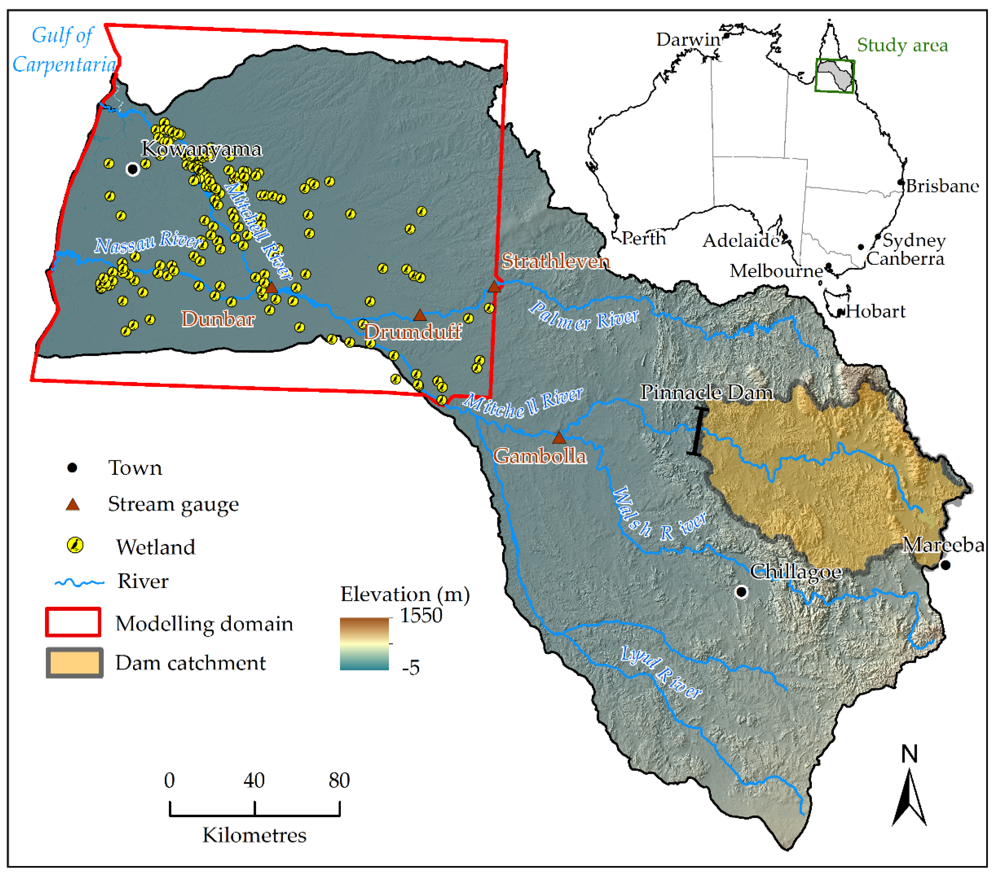
2. Study Area
3. Methods
3.1. Input Data
3.2. Inundation Modelling
3.2.1. Model Configuration and Simulation
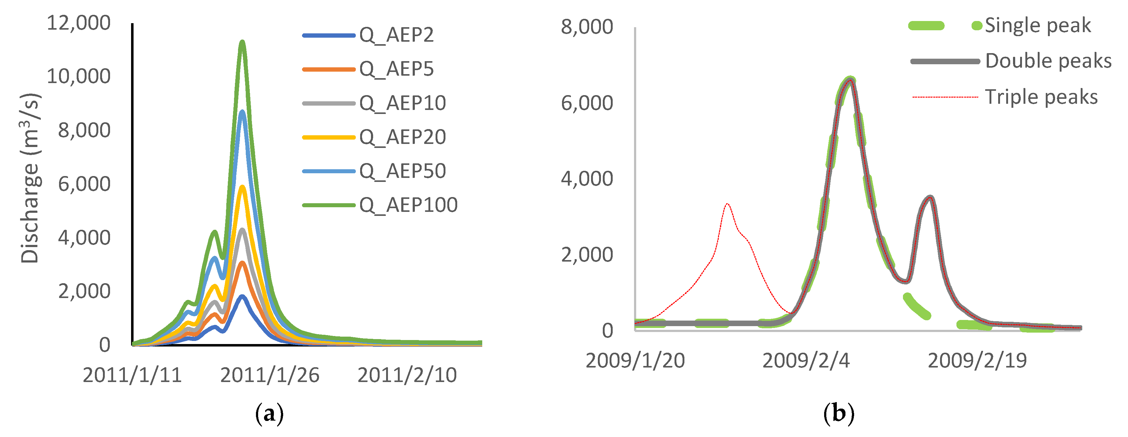
3.2.2. Floods Events of Scenario Modelling
3.3. Mapping Floodplain Wetland
3.4. Connectivity Assessment
3.5. Scenario Modelling
4. Results
4.1. Inundation Extent
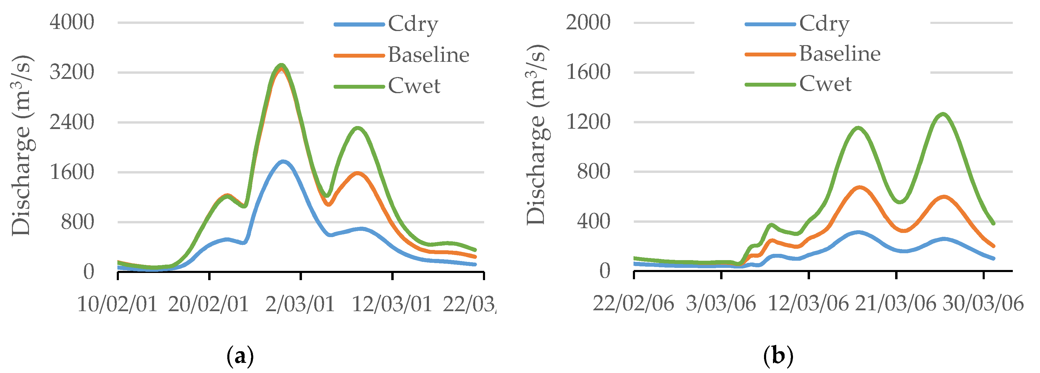
4.2. Inundation Duration
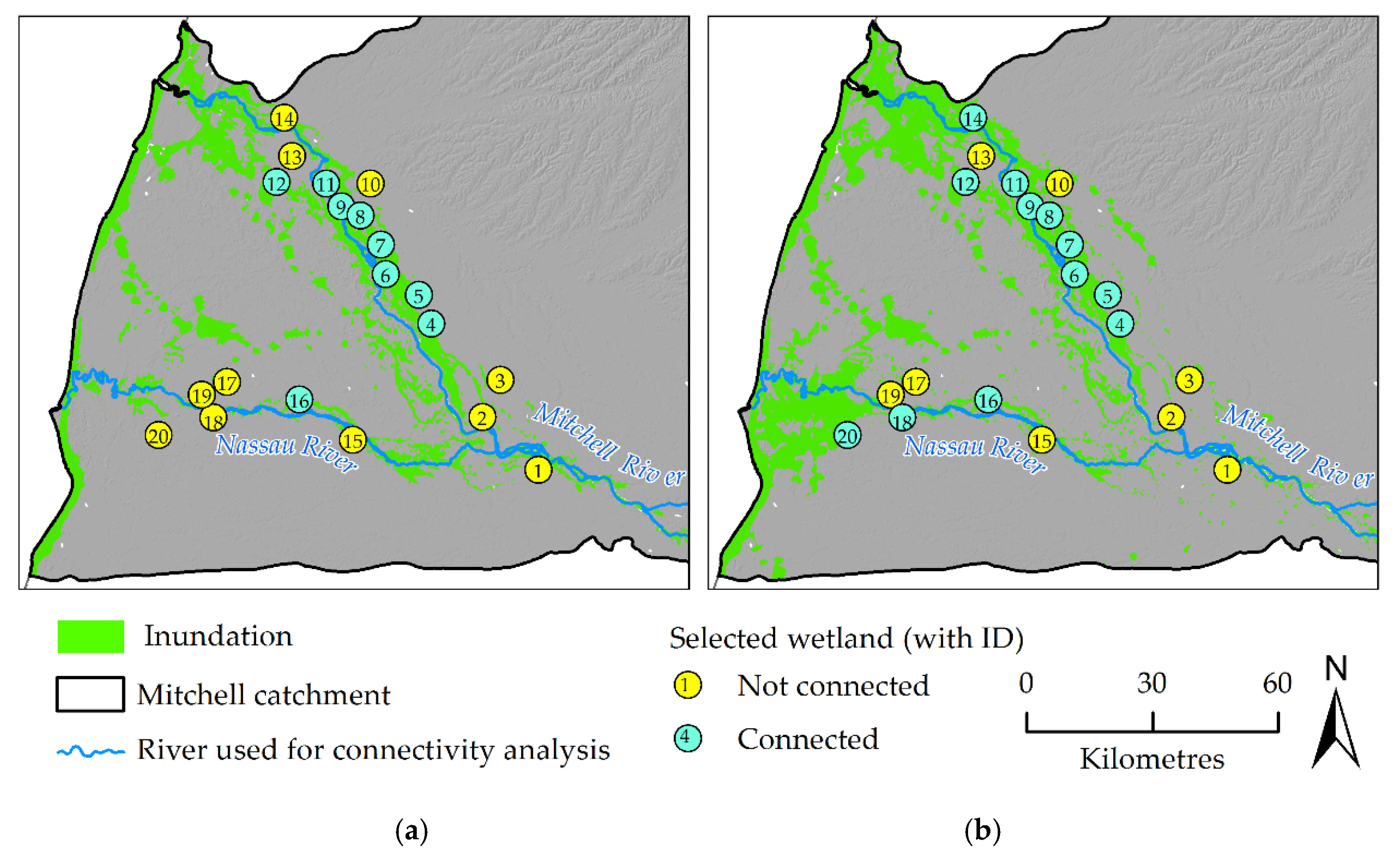
4.3. Wetland Connectivity
5. Discussion
6. Conclusions
Author Contributions
Funding
Acknowledgments
Conflicts of Interest
References
- Waltham, N.J.; Burrows, D.; Wegscheidl, C.; Buelow, C.; Ronan, M.; Connolly, N.; Groves, P.; Marie-Audas, D.; Creighton, C.; Sheaves, M. Lost Floodplain Wetland Environments and Efforts to Restore Connectivity, Habitat, and Water Quality Settings on the Great Barrier Reef. Front. Mar. Sci. 2019, 6. [Google Scholar] [CrossRef]
- Arthington, A.H.; Godfrey, P.C.; Pearson, R.G.; Karim, F.; Wallace, J. Biodiversity values of remnant freshwater floodplain lagoons in agricultural catchments: Evidence for fish of the Wet Tropics bioregion, northern Australia. Aquat. Conserv. Mar. Freshw. Ecosyst. 2014, 25, 336–352. [Google Scholar] [CrossRef]
- Pearson, R.G.; Godfrey, P.C.; Arthington, A.H.; Wallace, J.; Karim, F.; Ellison, M. Biophysical status of remnant freshwater floodplain lagoons in the Great Barrier Reef catchment: A challenge for assessment and monitoring. Mar. Freshw. Res. 2013, 64, 208–222. [Google Scholar] [CrossRef]
- Smardon, R. Wetland Ecology Principles and Conservation, Second Edition. Water 2014, 6, 813–817. [Google Scholar] [CrossRef] [Green Version]
- Briggs, S.V.; Thornton, S.A. Management of water regimes in River Red Gum Eucalyptus camaldulensis wetlands for water bird breeding. Aust. Zool. 1999, 31, 187–197. [Google Scholar] [CrossRef]
- Leigh, C.; Sheldon, F. Hydrological connectivity drives patterns of macroinvertebrate biodiversity in floodplain rivers of the Australian wet dry tropics. Freshwater Biol. 2009, 54, 549–571. [Google Scholar] [CrossRef] [Green Version]
- Greenway, M.; Woolley, A. Constructed wetlands in Queensland: Performance efficiency and nutrient bioaccumulation. Ecol. Eng. 1998, 12, 19–55. [Google Scholar] [CrossRef]
- McJannet, D.; Wallace, J.; Keen, R.; Hawdon, A.; Kemei, J. The filtering capacity of a tropical riverine wetland: II. Sediment and nutrient balances. Hydrol. Process. 2012, 26, 53–72. [Google Scholar] [CrossRef]
- Bunn, S.E.; Arthington, A.H. Basic principles and ecological consequences of altered flow regimes for aquatic biodiversity. Environ. Manag. 2002, 30, 492–507. [Google Scholar] [CrossRef] [Green Version]
- Opperman, J.J.; Galloway, G.E.; Fargione, J.; Mount, J.F.; Richter, B.D.; Secchi, S. Sustainable Floodplains Through Large-Scale Reconnection to Rivers. Science 2009, 326, 1487–1488. [Google Scholar] [CrossRef]
- Tockner, K.; Lorang, M.S.; Stanford, J.A. River flood plains are model ecosystems to test general hydrogeomorphic and ecological concepts. River Res. Appl. 2010, 26, 76–86. [Google Scholar] [CrossRef]
- Tockner, K.; Bunn, S.E.; Quinn, G.; Naiman, R.; Stanford, J.A.; Gordon, C. Floodplains: Critically threatened ecosystems. In Aquatic Ecosystems; Polunin, N.C., Ed.; Cambridge University Press: Cambridge, UK, 2008; pp. 45–61. [Google Scholar]
- Burket, V.; Kusler, J. Climate change: Potential impacts and interactions in wetlands of the United States. J. Am. Water Resour. Assoc. 2000, 36, 313–320. [Google Scholar] [CrossRef]
- Dawson, T.P.; Berry, P.M.; Kampa, E. Climate change impacts on freshwater wetland habitats. J. Nat. Conserv. 2003, 11, 25–30. [Google Scholar] [CrossRef]
- Erwin, K.L. Wetlands and global climate change: The role of wetland restoration in a changing world. Wetl. Ecol. Manag. 2009, 17, 71–84. [Google Scholar] [CrossRef]
- Kingsford, R.T. Conservation management of rivers and wetlands under climate change: A synthesis. Mar. Freshw. Res. 2011, 62, 217–222. [Google Scholar] [CrossRef]
- Junk, W.J.; Bayley, P.B.; Sparks, R.E. The flood pulse concept in river-floodplain systems. Can. Spec. Publ. Fish. Aquat. Sci. 1989, 106, 110–127. [Google Scholar]
- Lyon, J.; Stuart, I.; Ramsey, D.; O’Mahony, J. The effect of water level on lateral movements of fish between river and off-channel habitats and implications for management. Mar. Freshw. Res. 2010, 61, 271–278. [Google Scholar] [CrossRef] [Green Version]
- Ward, J.V.; Tockner, K.; Schiemer, F. Biodiversity of floodplain river ecosystems: Ecotones and connectivity. Regul. Rivers Res. Manag. 1999, 15, 25–139. [Google Scholar] [CrossRef]
- Pringle, C.M. Hydrologic connectivity and the management of biological reserves: A global perspective. Ecological Applications. Ecol. Appl. 2001, 11, 981–998. [Google Scholar] [CrossRef]
- Balcombe, S.R.; Bunn, S.E.; Arthington, A.H.; Fawcett, J.H.; Mckenzie-Smith, F.J.; Wright, A. Fish larvae, growth and biomass relationships in an Australian arid zone river: Links between floodplains and waterholes. Freshwater Biol. 2007, 52, 2385–2398. [Google Scholar] [CrossRef] [Green Version]
- Lasne, E.; Lek, S.; Laffaille, P. Patterns in fish assemblages in the Loire floodplain: The role of hydrological connectivity and implications for conservation. Biol. Conserv. 2007, 139, 258–268. [Google Scholar] [CrossRef]
- Steffensen, K.D.; Eder, B.L.; Pegg, M.A. Fish community response to floodplain inundation in a regulated river. J. Freshwater Ecol. 2014, 29, 413–427. [Google Scholar] [CrossRef] [Green Version]
- Van, P.D.T.; Popescu, I.; van Griensven, A.; Solomatine, D.P.; Trung, N.H.; Green, A. A study of the climate change impacts on fluvial flood propagation in the Vietnamese Mekong Delta. Hydrol. Earth Syst. Sci. 2012, 16, 4637–4649. [Google Scholar] [CrossRef] [Green Version]
- Langerwisch, F.; Rost, S.; Gerten, D.; Poulter, B.; Rammig, A.; Cramer, W. Potential effects of climate change on inundation patterns in the Amazon Basin. Hydrol. Earth Syst. Sci. 2013, 17, 2247–2262. [Google Scholar] [CrossRef] [Green Version]
- Rouillard, A.; Skrzypek, G.; Dogramaci, S.; Turney, C.; Grierson, P.F. Impacts of a changing climate on a century of extreme flood regime of northwest Australia. Hydrol. Earth Syst. Sci. Discuss. 2014, 11, 11905–11943. [Google Scholar] [CrossRef]
- Schumann, G. Preface: Remote Sensing in Flood Monitoring and Management. Remote Sens. 2015, 7, 17013–17015. [Google Scholar] [CrossRef] [Green Version]
- Bates, P.D. Remote sensing and flood inundation modelling. Hydrol. Processes 2004, 18, 2593–2597. [Google Scholar] [CrossRef]
- Overton, I.C. Modelling floodplain inundation on a regulated river: Integrating GIS, remote sensing and hydrological models. River Res. Appl. 2005, 21, 991–1001. [Google Scholar] [CrossRef]
- Frazier, P.; Page, K. A reach-scale remote sensing technique to relate wetland inundation to river flow. River Res. Appl. 2009, 25, 836–849. [Google Scholar] [CrossRef]
- Shaikh, M.; Green, D.; Cross, H. A remote sensing approach to determine environmental flows for wetlands of the Lower Darling River, New South Wales, Australia. Int. J. Remote Sens. 2001, 22, 1737–1751. [Google Scholar] [CrossRef]
- Van de Sande, B.; Lansen, J.; Hoyng, C. Sensitivity of Coastal Flood Risk Assessments to Digital Elevation Models. Water 2012, 4, 568–579. [Google Scholar] [CrossRef]
- Teng, J.; Jakeman, A.J.; Vaze, J.; Croke, B.F.W.; Dutta, D.; Kim, S. Flood inundation modelling: A review of methods, recent advances and uncertainty analysis. Environ. Modell. Softw. 2017, 90, 201–216. [Google Scholar] [CrossRef]
- Tuteja, N.K.; Shaikh, M. Hydraulic modelling of the spatiio-temporal flood inundation patterns of the Koondrook Perricoota forest wetlands- the living Murray. In 18th World IMACS, MODSIM Congress; Modelling and Simulation Society of Australia and New Zealand: Cairns, Australia, 2009; pp. 4248–4254. [Google Scholar]
- Hardesty, S.; Shen, X.; Nikolopoulos, E.; Anagnostou, E. A Numerical Framework for Evaluating Flood Inundation Hazard under Different Dam Operation Scenarios—A Case Study in Naugatuck River. Water 2018, 10, 1798. [Google Scholar] [CrossRef] [Green Version]
- Mihu-Pintilie, A.; Cîmpianu, C.I.; Stoleriu, C.C.; Pérez, M.N.; Paveluc, L.E. Using High-Density LiDAR Data and 2D Streamflow Hydraulic Modeling to Improve Urban Flood Hazard Maps: A HEC-RAS Multi-Scenario Approach. Water 2019, 11, 1832. [Google Scholar] [CrossRef] [Green Version]
- Karim, F.; Petheram, C.; Marvanek, S.; Ticehurst, C.; Wallace, J.; Hasan, M. Impact of climate change on floodplain inundation and hydrological connectivity between wetlands and rivers in a tropical river catchment. Hydrol. Processes 2016, 30, 1574–1593. [Google Scholar] [CrossRef]
- Mackay, C.; Suter, S.; Albert, N.; Morton, S.K.Y. Large scale flexible mesh 2D modelling of the Lower Namoi Valley. In Floodplain Management Association National Conference; Floodplain Management Australia: Brisbane, Australia, 2015; pp. 1–14. [Google Scholar]
- Symonds, A.M.; Vijverberg, T.; Post, S.; van der Spek, B.; Henrotte, J.; Sokolewicz, M. Comparison between Mike 21 FM, Delft3D and Delft3D FM flow models of Western Port Bay, Australia. In Proceedings of the 35th International Conference on Coastal Engineering, Antalya, Turkey, 17–20 November 2016; pp. 1–12. [Google Scholar]
- Charles, S.; Petheram, C.; Berthet, A.; Browning, G.; Hodgson, G.; Wheeler, M.; Yang, A.; Gallant, S.; Marshall, A.; Hendon, H.; et al. Climate Data and Their Characterisation for Hydrological and Agricultural Scenario Modelling across the Fitzroy, Darwin and Mitchell Catchments: A Technical Report from the CSIRO Northern Australia Water Resource Assessment to the Government of Australia; CSIRO: Canberra, Australia, 2016; p. 159. [Google Scholar]
- Ward, D.P.; Hamilton, S.K.; Jardine, T.D.; Pettit, N.E.; Tews, E.K.; Olley, J.M.; Bunn, S.E. Assessing the seasonal dynamics of inundation, turbidity, and aquatic vegetation in the Australian wet-dry tropics using optical remote sensing. Ecohydrology 2013, 6, 312–323. [Google Scholar] [CrossRef] [Green Version]
- Kennard, M.J. Priorities for Identification and Sustainable Management of High Conservation Value Aquatic Ecosystems in Northern Australia; Department of Sustainability, Environment, Water, Population and Communities, Darwin: Canberra, Australia, 2011; p. 72.
- Mitsch, W.J.; Bernal, B.; Hernandez, M.E. Ecosystem services of wetlands. Int. J. Biodivers. Sci. Ecosyst. Serv. Manag. 2015, 11, 1–4. [Google Scholar] [CrossRef] [Green Version]
- Gallant, J.C.; Dowling, T.I.; Read, A.M.; Wilson, N.; Tickle, P.K.; Inskeep, C. SRTM-Derived 1 Second Digital Elevation Models Version 1.0.; Geoscience Australia: Canberra, Australia, 2011. [Google Scholar]
- Karim, F.; Pena-Arancibia, J.; Ticehurst, C.; Marvanek, S.; Gallant, J.C.; Hughes, J.; Dutta, D.; Vaze, J.; Petheram, C.; Seo, L.; et al. Floodplain Inundation Mapping and Modelling for the Fitzroy, Darwin and Mitchell Catchments: A Technical Report from the CSIRO Northern Australia Water Resource Assessment to the Government of Australia; Commonwealth Scientific and Industrial Research Organisation: Canberra, Australia, 2018; p. 171. [Google Scholar]
- Lymburner, L.; Tan, P.; Mueller, N.; Thackway, R.; Lewis, A.; Thankappan, M.; Randall, L.; Islam, A.; Senarath, U. The National Dynamic Land Cover Dataset; 2011/31; Geoscience Australia: Canberra, Australia, 2011; p. 105. [Google Scholar]
- Chow, V.T. Open Channel Hydraulics; McGraw-Hill International Edition: Singapore, 1959; p. 680. [Google Scholar]
- LWA. An Australian Handbook of Stream Roughness Coefficients; Land and Water Australia: Canberra, Australia, 2009; p. 28. [Google Scholar]
- DHI. MIKE21 Flow Model FM, Hydrodynamic Module, User Guide; DHI Water and Environment Pty Ltd: Horsholm, Denmark, 2016. [Google Scholar]
- Gringorten, I.I. A Plotting Rule for Extreme Probability Paper. J. Geophys. Res. 1963, 68, 813–814. [Google Scholar] [CrossRef]
- Karim, F.; Kinsey-Henderson, A.; Wallace, J.; Arthington, A.H.; Pearson, R.G. Modelling wetland connectivity during overbank flooding in a tropical floodplain in north Queensland, Australia. Hydrol. Processes 2012, 26, 2710–2723. [Google Scholar] [CrossRef] [Green Version]
- Mueller, N.; Lewis, A.; Roberts, D.; Ring, S.; Melrose, R.; Sixsmith, J.; Lymburner, L.; McIntyre, A.; Tan, P.; Curnow, S.; et al. Water observations from space: Mapping surface water from 25 years of Landsat imagery across Australia. Remote Sens. Environ. 2016, 174, 341–352. [Google Scholar] [CrossRef] [Green Version]
- Godfrey, P.C.; Arthington, A.H.; Pearson, R.G.; Karim, F.; Wallace, J. Fish larvae and recruitment patterns in floodplain lagoons of the Australian Wet Tropics. Mar. Freshw. Res. 2017, 68. [Google Scholar] [CrossRef]
- IPCC. Climate Change 2014, Synthesis Report, Contribution of Working Groups I, II and III to the Fifth Assessment Report of the Intergovernmental Panel on Climate Change; IPCC: Geneva, Switzerland, 2014; p. 151. [Google Scholar]
- Hughes, J.; Yang, A.; Wang, B.; Marvanek, S.; Carlin, L.; Seo, L.; Petheram, C.; Vaze, J. Calibration of river System and Landscape Models for the Fitzroy, Darwin and Mitchell Catchments: A Technical Report from the CSIRO Northern Australia Water Resource Assessment to the Government of Australia; CSIRO: Canberra, Australia, 2017; p. 129. [Google Scholar]


| Wetland ID | Longitude (°) | Latitude (°) | Nearest River | Area (m2 × 104) | Lateral Distance (km) |
|---|---|---|---|---|---|
| 1 | 142.51 | −15.96 | Mitchell river | 8.47 | 3.48 |
| 2 | 142.34 | −15.90 | Mitchell river | 1.18 | 2.16 |
| 3 | 142.47 | −15.95 | Mitchell river | 15.33 | 13.6 |
| 4 | 142.22 | −15.70 | Mitchell river | 3.47 | 4.51 |
| 5 | 142.19 | −15.64 | Mitchell river | 6.74 | 7.67 |
| 6 | 142.12 | −15.60 | Mitchell river | 4.28 | 2.01 |
| 7 | 142.10 | −15.54 | Mitchell river | 0.30 | 3.26 |
| 8 | 142.06 | −15.48 | Mitchell river | 0.82 | 4.08 |
| 9 | 142.01 | −15.46 | Mitchell river | 0.54 | 0.83 |
| 10 | 142.07 | −15.41 | Mitchell river | 0.01 | 9.95 |
| 11 | 141.98 | −15.41 | Mitchell river | 1.86 | 1.68 |
| 12 | 141.87 | −15.40 | Mitchell river | 5.88 | 8.47 |
| 13 | 141.90 | −15.35 | Mitchell river | 1.44 | 4.46 |
| 14 | 141.88 | −15.27 | Mitchell river | 6.57 | 1.91 |
| 15 | 142.06 | −15.96 | Nassau river | 7.25 | 1.88 |
| 16 | 141.93 | −15.87 | Nassau river | 5.92 | 3.54 |
| 17 | 141.77 | −15.84 | Nassau river | 1.50 | 6.66 |
| 18 | 141.74 | −15.92 | Nassau river | 4.65 | 2.04 |
| 19 | 141.71 | −15.87 | Nassau river | 2.93 | 2.61 |
| 20 | 141.62 | −15.96 | Nassau river | 5.84 | 9.89 |
| Flood Event | AEP (years) | Mean Connectivity (days) | Change in Connectivity, Days (%) | ||||
|---|---|---|---|---|---|---|---|
| Cdry | Cwet | Dam | Cdry and Dam | Cwet and Dam | |||
| 2001 | 1 in 10 | 3.2 | −1.8 (56) | +0.5 (15) | −1.5 (47) | −2.2 (69) | −1.2 (39) |
| 2006 | 1 in 2 | 1.2 | −0.6 (53) | +1.0 (83) | −0.6 (51) | −0.9 (72) | +0.1 (11) |
| 2009 | 1 in 26 | 4.9 | −1.6 (33) | +0.03 (1) | −1.7 (34) | −2.7 (55) | −0.7 (15) |
© 2020 by the authors. Licensee MDPI, Basel, Switzerland. This article is an open access article distributed under the terms and conditions of the Creative Commons Attribution (CC BY) license (http://creativecommons.org/licenses/by/4.0/).
Share and Cite
Karim, F.; Marvanek, S.; Merrin, L.E.; Nielsen, D.; Hughes, J.; Stratford, D.; Pollino, C. Modelling Flood-Induced Wetland Connectivity and Impacts of Climate Change and Dam. Water 2020, 12, 1278. https://doi.org/10.3390/w12051278
Karim F, Marvanek S, Merrin LE, Nielsen D, Hughes J, Stratford D, Pollino C. Modelling Flood-Induced Wetland Connectivity and Impacts of Climate Change and Dam. Water. 2020; 12(5):1278. https://doi.org/10.3390/w12051278
Chicago/Turabian StyleKarim, Fazlul, Steve Marvanek, Linda E. Merrin, Daryl Nielsen, Justin Hughes, Danial Stratford, and Carmel Pollino. 2020. "Modelling Flood-Induced Wetland Connectivity and Impacts of Climate Change and Dam" Water 12, no. 5: 1278. https://doi.org/10.3390/w12051278
APA StyleKarim, F., Marvanek, S., Merrin, L. E., Nielsen, D., Hughes, J., Stratford, D., & Pollino, C. (2020). Modelling Flood-Induced Wetland Connectivity and Impacts of Climate Change and Dam. Water, 12(5), 1278. https://doi.org/10.3390/w12051278


