Article

Managed Aquifer Recharge of Monsoon Runoff Using Village Ponds: Performance Assessment of a Pilot Trial in the Ramganga Basin, India

1
International Water Management Institute, New Delhi 110012, India
2
International Water Management Institute, Vientiane 4199, Laos
*
Author to whom correspondence should be addressed.
Water 2020, 12(4), 1028; https://doi.org/10.3390/w12041028
Submission received: 25 November 2019 / Revised: 30 March 2020 / Accepted: 31 March 2020 / Published: 4 April 2020
(This article belongs to the Special Issue Managed Aquifer Recharge for Water Resilience)

Abstract

:
The managed aquifer recharge (MAR) of excess monsoonal runoff to mitigate downstream flooding and enhance groundwater storage has received limited attention across the Indo-Gangetic Plain of the Indian subcontinent. Here, we assess the performance of a pilot MAR trial carried out in the Ramganga basin in India. The pilot consisted of a battery of 10 recharge wells, each 24 to 30 m deep, installed in a formerly unused village pond situated adjacent to an irrigation canal that provided river water during the monsoon season. Over three years of pilot testing, volumes ranging from 26,000 to 62,000 m3 were recharged each year over durations ranging from 62 to 85 days. These volumes are equivalent to 1.3–3.6% of the total recharge in the village, and would be sufficient to irrigate 8 to 18 hectares of rabi season crop. High inter-year variation in performance was observed, with yearly average recharge rates ranging from 430 to 775 m3 day−1 (164–295 mm day−1) and overall average recharge rates of 580 m3 day−1 (221 mm day−1). High intra-year variation was also observed, with recharge rates at the end of recharge period reducing by 72%, 88% and 96% in 2016, 2017 and 2018 respectively, relative to the initial recharge rates. The observed inter- and intra-year variability is due to the groundwater levels that strongly influence gravity recharge heads and lateral groundwater flows, as well as the source water quality, which leads to clogging. The increase in groundwater levels in response to MAR was found to be limited due to the high specific yield and transmissivity of the alluvial aquifer, and, in all but one year, was difficult to distinguish from the overall groundwater level rise due to a range of confounding factors. The results from this study provide the first systematic, multi-year assessment of the performance of pilot-scale MAR harnessing village ponds in the intensively groundwater irrigated, flood prone, alluvial aquifers of the Indo-Gangetic Plain.

1. Introduction

The inter- and intra-annual variability of water availability, manifesting in extreme flood and drought events, presents a considerable challenge to ensuring water security globally [1,2]. This variation in water availability, separated by time and space, co-exists in most river basins globally [2]. The impact of water variability is magnified in the agriculture sector due to its strong dependence on climate. This is exemplified by the fact that of the total loss of USD 80 billion in crop and livestock production in 67 countries between 2003 and 2013, due to 140 medium-to-large-scale disasters (including non-water related events), 83% was caused by flood or drought [3]. With climate change increasing rainfall variability and inducing more and severe extreme weather events, the predictability of water availability will further reduce in coming years [4,5], prompting the need for urgent attention to adaptation.
Groundwater, with its high buffering capacity due to relatively large storage [6], presents a potential opportunity to resolve the temporal and spatial imbalances in water supply and availability. The extensive use of groundwater, in many places leading to overexploitation [7], also creates additional depleted storage. This additional storage capacity could be used, similarly to dams, to capture excess monsoonal runoff in the wet season, making it available during dry periods, and thus mitigating both flood and drought hazards [8].
One novel way of operationalizing this concept is “Underground Transfer of Floods for Irrigation (UTFI)” [8,9]. UTFI is a form of managed aquifer recharge (MAR) that involves the targeted recharge of excess monsoonal runoff that potentially poses a flood risk downstream, in aquifers at the basin scale through the strategic establishment of groundwater recharge infrastructure to mitigate flooding and enhance groundwater storage [8,10]. Enhanced groundwater storage increases water availability so that the water can be used during the dry season for domestic, livestock or irrigation use, or, if retained, can support dry season inflows, enhancing ecosystem services [11].
Efforts to test UTFI started in the Ganges river basin, with its high population density, cropping intensity, recurring floods and droughts due to the concentrated monsoon season [11,12] along with extensive aquifer systems (underlain by highly productive alluvial aquifers of the Indo-Gangetic Plain) used intensively for irrigation [13]. These characteristics present both the favorable conditions and challenges UTFI aims to solve. A GIS-based multi-criteria analysis revealed high suitability across the Ganges basin [9].
However, to successfully implement UTFI at the basin scale requires thoughtful planning and staged testing and development to minimize the potential environmental, social and financial risks [8]. Though there are some MAR pilot studies in porous alluvial aquifers of the Indo-Gangetic Plain [14,15,16], they lack the long term comprehensive and systematic approaches required to assess how UTFI would perform if upscaled. This is unlike the case in hard rock settings in India where experience is much more extensive [17,18,19]. Therefore, the piloting and testing of UTFI was carried out to generate the body of knowledge necessary to establish the scope for wider implementation across similar settings. This paper presents the learnings gained from piloting in hydraulic- and hydrological-related aspects. Detailed information on site selection and setting up the pilot is covered in [8], and these are briefly covered here. A broader perspective on the findings from the piloting can be gained from related studies on water quality, and environmental and socio-institutional aspects [20,21].

2. Study Area

Pilot testing was carried out in Jiwai Jadid village, located in Rampur district, Uttar Pradesh, India (Figure 1). The climate of the area is sub-humid and characterized by hot, humid summers and cold winters. The average annual rainfall of Rampur district is 933 mm, and about 85% of the rainfall is received during the south-western monsoon between June and September. Agriculture is the primary means of livelihood in the district, with about 60% of the working population reliant on agriculture. This is reflected in the land use of the district, where 81% of the 2357 km2 area is under cropping [22,23]. The major cropping pattern of the district is paddy and wheat, grown in two major seasons known as the kharif (coinciding with the monsoon season: June to November) and rabi (November to March), respectively.
Concentrated rainfall during the monsoon months leads to excess water/floods, followed by limited water availability during the non-monsoon season. High flows in the Ramganga river and its tributaries (e.g., the Kosi and Pilakhar rivers) during the monsoon season makes flooding a recurrent and major problem in Rampur and the surrounding districts. Major flooding experienced in Rampur in 1973 affected almost 238,165 people across 561 villages and impacted a total crop area of 144,836 ha. In recent years, floods have been reported in 2010, 2013 and 2015, affecting 15, 18 and 207 villages, respectively [24,25,26].
Rampur district is intensively irrigated (~99.8% of the cropped area), with groundwater being the main source of irrigation (~97%) [27]. Around 80,000 shallow tube wells equipped with diesel-powered centrifugal pumps account for most of the groundwater pumped. Intensive groundwater irrigation in the district is made possible by the highly productive Indo-Gangetic Plain alluvial aquifers that underlie much of northern India, as well as several neighboring countries [13]. There are four aquifer groups present in the area down to 440 metres below ground level (mbgl). The first aquifer group is unconfined and extends down to depth of 60 to 90 mbgl [28], and is utilized mostly for irrigation.
Average groundwater table depths in Rampur district range from 4–8 m during the monsoon and 8–12 m in the non-monsoon months [28]. However, as a result of the intensive demand for groundwater year-round, groundwater overexploitation is a risk, with groundwater tables falling across the district. The number of ‘dark’ administrative blocks, a Government of India term representing a high level of overexploitation of groundwater resources, has increased from only one block in 2003 to four blocks in 2013 (out of a total of six blocks in the district) [29].
Intra seasonal water availability, variability, recurrent floods and high irrigation demand with intensive groundwater irrigation, leading to groundwater overexploitation in the region, provides the challenging conditions well-suited to piloting UTFI.

3. Pilot Trial Design

The UTFI pilot features 10 gravity-fed recharge wells of 150 mm diameter (PVC pipe) installed in the village pond (Figure 2). Recharge wells were drilled to depths of 24–30 m with gravel packing, and the lowest 18 m of pipe was screened. The village pond was used to install UTFI infrastructure, as land availability is a serious constraint owing to high population density and intensive year-round cultivation in the region. The pond (75 × 35 m) was dewatered and excavated to a depth of 2.5 m, creating a maximum storage capacity of 5250 m3. To ensure a common reference point for the measurement of the water table in the piezometers and the pond, the top of the recharge well RW1 (Figure 2), which was 2.1 m above the base of the pond, was selected. With the bottom of the pond at 2.1 mbgl and the lowest pond level that allowed water to enter recharge wells at 1.1 mbgl, the height of dead storage in the pond was 1.0 m. Water, after the pond water level was above dead storage, entered the wells only through a pea-gravel-filled chamber, to filter out suspended silts. Nine piezometers were installed with P1, P2, P3, P6 and P7 positioned along a transect in the direction of groundwater flow from north to south, whilst P4 and P5 (deep (D) and shallow (S) pairs for each) were positional along a shorter north-south transect.
The source water (i.e., excess rain water/flood water) is brought to the site through a canal (Left Pilakhar canal) that is situated next to the pond. This canal carries water from the Pilakhar river and provides water for irrigation during the summer and winter seasons, though the crops in the pilot village were not irrigated by canal water. However, during the monsoon season, the canal flow was more than the irrigation demand, and excess water flowed downstream to the river/canal. A de-siltation chamber (2 × 2 × 1.5 m) was also built at the intake of the pond (Figure 2).

Operation and Maintenance

Pilot operations during the trial period were handled with the support of an appointed village representative, who was provided training on the protocols. Recharge was done only during the monsoon season when the water level in the canal was above a pre-defined level of 0.6 m. The water from the canal was initially pumped into the pond over an embankment using a diesel-operated pump for 15 min, and thereafter, it flowed naturally under gravity (siphon flow) due to the water level difference.
Maintenance of the UTFI system to enhance the recharge rates included three main types of activities:
  • Recharge well cleaning: recharge wells were cleaned using a compressor to remove silt deposited inside the recharge wells and fine particles that had blocked the slots of the recharge well.
  • Recharge well filter cleaning: pea-gravels in the recharge filters packed in brick structures were cleaned by removing and washing by hand.
  • Desilting pond bottom: silt deposited at the pond bottom was scraped off, and the embankments and side slopes were restabilized.

4. Methods

4.1. Monitoring and Data Collection

Table 1 gives an overview of the different parameters measured, methodologies applied and frequencies of observations in accordance with a monitoring protocol prepared to guide the monitoring of the physical dimensions of the pilot system.

4.2. Groundwater Recharge from the UTFI Pond

Groundwater recharge from the UTFI pond (VUTFI), consisting of recharge from 10 gravity recharge wells and infiltration from the pond bottom, was estimated from the observed decrease in volume of water stored in the pond over a period of time (Equation (1)). To estimate the change in volume, a specific depth-storage relationship representing the volume of water relative to the corresponding water depth in the pond was developed based on the geometry of the structure. Groundwater recharge tests were conducted over durations of about 12 h at approximately 10 day intervals during the recharge periods.
V U T F I ( d ) = Δ V v p t i t i + 1
where V U T F I ( d ) = the recharge rate of UTFI pond (m3 h−1) at day d from the start of the recharge period; Δ V v p is the change in the volume of water in the pond (m3) between the start ( t i ) and end ( t i + 1 ) of the monitoring period based on the depth-storage function, and t i t i + 1 = the duration of the test period (hours). The evaporation rate (6–9 mm day−1 during the recharge period, or 3–4.5 mm day−1 during the recharge test) was assumed to be negligible in the calculation.
The total recharge for the whole season was then calculated by summing up the recharges between the two tests at days d and d + i (Equation (2)). The recharge rates at the start and end of the trial were taken to be equal to the first and last measured recharge rates, respectively.
V U T F I = i = 1 n ( ( R U T F I ( d ) + R U T F I ( d + i ) ) × 24 2 ) × ( ( d + i ) ( d ) )
where VUTFI is the volume of water recharge (m3), n is the total number of recharge tests conducted, and RUTFI(d) and RUTFI(d+i) are the recharge rates on days d and d + i respectively.
The average recharge rate (RUTFI) for the UTFI pond for the whole recharge season in m3 day−1 is calculated by dividing the total recharge by the number of recharge days.

4.3. Groundwater Level Response to UTFI Recharge

Groundwater level changes during the recharge periods in response to UTFI recharge was analyzed from monitored groundwater levels in the piezometers and relative mound formation, which is the difference in groundwater levels at distance d from a reference piezometer caused by UTFI recharge. Relative mound height provides a key measure of the hydraulic impact of UTFI recharge, on the assumption that other factors impacting groundwater levels will influence all of the piezometers uniformly. Groundwater level comparisons before and after UTFI were not possible as this required historical data in the village that were lacking, as monitoring only started with the commencement of the pilot.
Concentrated recharge over the small pilot area would lead to the formation of a relative mound, and, as time progressed and groundwater spreaded horizontally, the relative mound would flatten and eventually dissipate after recharge operations ceased [30,31]. The relative mound (Equation (3)) at distance r from the UTFI pond and days d after recharge started (Hmound(r,d)) was estimated against the groundwater level of the referenced piezometer (GWL(ref,d)). The selection of the specific reference piezometer, which is expected to be unaffected (or the least affected) by recharge operations, was based on the groundwater level observations covered in the results section.
Hmound(r,d) = GWL(r,d) − GWL(ref,d)
where Hmound(r,d) is the mound height at distance r from the pond at day d from the start of recharge period, and GWL(r,d) and GWL(ref,d) are the groundwater levels at distance r and at the reference piezometer at day d after the start of the recharge period.

The Hantush Analytical Solution

The Hantush analytical solution [31] was used to model mound formation in order to study the impact of UTFI recharge alone on relative mound formation, thus distinguishing it from other potentially confounding factors (such as rainfall, groundwater pumping, recharge from canal and river and regional groundwater flow) and to substantiate the field observations from Equation (3). The Hantush solution gives the growth and decay of groundwater mounds beneath rectangular or circular infiltration basins [31] and has been used in numerous studies to provide insights into mounding behavior [32,33]. In this analysis, the ten recharge wells are approximated as a uniform recharge source over the rectangular area of the pond.
To apply the Hantush solution, a spreadsheet solution of the equation was used [34]. To simulate mounding with decreasing recharge rates, mound height was estimated at 5 day intervals (up to 80 days) from the start of recharge operations, and the corresponding 5 day average recharge rates were calculated (based on Equation (2)) and given as input. Aquifer characteristics (a hydraulic conductivity of 20 m day−1 and a specific yield of 0.1) were assumed to be uniform over the study area [35].

4.4. Groundwater Bbalance at the Village Scale

The magnitude of UTFI recharge (VUTFI) relative to the total groundwater recharge over the village area (Figure 2) is estimated to draw inferences on how additional recharge from UTFI pond contributes to overall groundwater recharge. The selection of the village boundary as the scale for analysis is largely for demonstrative purposes. It was deemed an appropriate scale as UTFI is designed as a village-level intervention, and its zone of influence is expected to be largely within village boundaries.
Village total recharge (m3) (Vvillage) is calculated using the water table fluctuation method [36] (Equation (4)). Post–monsoon recharge is considered negligible as more than 90% of the rainfall in all 3 years took place during the monsoon season [35]. In Equation (4), Vvillage is made up of recharge from the UTFI pond (VUTFI), as well as recharge from canal seepage and other village ponds. Also, storage change due to any net inflow across village boundaries is accounted for.
V v i l l a g e = Δ G W S + V A m o n s o o n = Δ H × S y × A v i l l a g e + V A m o n s o o n
where Δ G W S (m3) = the change in village groundwater storage, Δ H (m) = the rise in water level in the monsoon season (estimated in any year from the average rise in all piezometers from the start of rainfall period to the end of September), Avillage (m2) = the area for the computation of recharge (village area), Sy = specific yield, and VAmonsoon (m3) = net groundwater abstraction in the monsoon season (taken to be equal to net abstraction for paddy in the kharif season).
Groundwater abstraction for irrigation was estimated based on the proportion of area irrigated with groundwater (based on information derived from the socio-economic survey), combined with the irrigation requirements of paddy as taken from [37]. Net abstraction was estimated from gross groundwater irrigation abstraction following groundwater resource estimation guidelines [35], which recommend that for groundwater depths of less than 10 metres, a return flow of 45% should be taken for paddy.

5. Results

5.1. Groundwater Recharge from UTFI

Table 2 summarizes UTFI recharge, average recharge rates and recharge duration from pilot testing for each year (2016–2018). On average, the recharge period (i.e., the number of days when the UTFI system was operated for recharge) was 75 days, recharging 44,415 m3 of water at an average recharge rate of 580 m3 day−1 (or 221 mm day−1 over the ponded area). The total volume recharged was 5.0–11.8 fold higher than the total storage capacity of the pond. The quantities of water recharged in 2016, 2017 and 2018 would have been sufficient to irrigate 12.8 ha, 17.7 ha and 7.5 ha of crop land (rabi wheat with an irrigation requirement of ~350 mm), respectively.
There is a high inter- and intra-year variation in the UTFI recharge and recharge rates, with the highest recharge (average) observed in 2017 and the lowest in 2018. The lowest recharge in 2018 was due to both the low recharge rates observed and the relatively shorter recharge period, with recharge lasting for only 62 days, in comparison to 85 and 78 days in 2016 and 2017, respectively. The short recharge season in 2018 was due to the delayed onset of the monsoon, which shortened the duration of recharge operations.
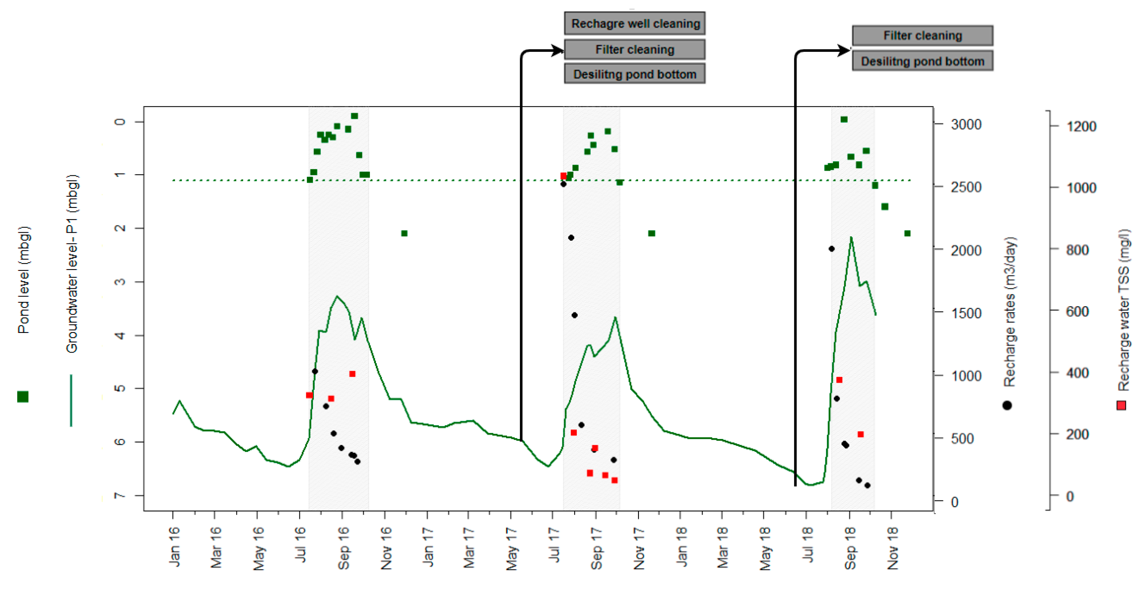
In all years, recharge rates started high and gradually declined during the recharging period (Figure 5). Starting recharge rates in 2016, 2017 and 2018 were 996, 2499, 1978 m3 day−1 respectively, which by the end of recharge period (when water storage in the pond was effectively dead storage) decreased to 274, 289 and 85 m3 day−1, i.e., there were reductions of 72.4%, 88.4% and 95.7%, respectively, from the starting conditions.

5.2. Groundwater Levels and the Response to UTFI Recharge

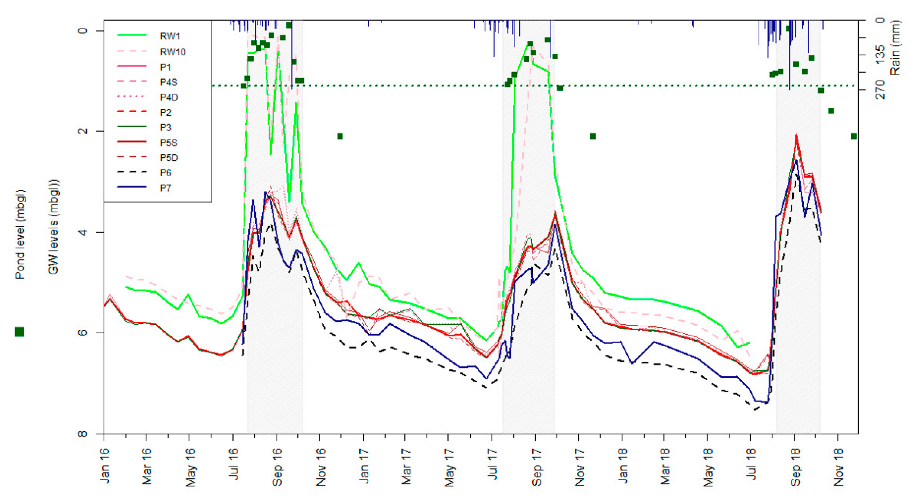
Figure 3 shows the monitored groundwater levels (relative to the reference point) for the piezometers and in recharge wells (RW1 and RW10), together with the pond water levels and daily rainfall over three years. The shallowest depth is observed in recharge wells with the highest depth in P6 and P7, which is as per the groundwater flow direction in the village. However, as all recharge wells (including RW1 and RW10) were used for recharge during recharge periods, they quickly filled and mainly indicated water levels in the pond (Figure 3). Thus, groundwater levels directly beneath the pond (beyond the recharge wells) could not be ascertained during recharge periods, and thus RW1 and RW10 were not used further in the analysis.
The pond water level during the entire recharge season remained above the minimum threshold level for recharge (dashed line in Figure 5), but shows some variation, with water highest during mid-season, which was also reflected in recharge well readings. As pond water levels are influenced by rainfall, the rate of siphoning from canal and also recharge rates, the precise reason for the variation remains unclear. The last readings of the pond level after each recharge period in Figure 5 show the times when the pond dried out. The pond water level readings indicate that for two discrete events, in September 2016 and August 2018, the water level rose above the recharge well heights, and thus potentially allowed unfiltered pond water to bypass the pea gravel filter and enter at the top of recharge well casings through small openings that serve to purge entrapped air. Though this happened for short time periods during high intensity rainfall events, it warrants building some margin of safety into recharge well heights in the future.
Despite extensive groundwater abstraction for the supplemental irrigation of paddy that takes place in the village, groundwater levels show a consistent rise in all piezometers during the monsoon season in all three years, coinciding with and then falling gradually over the non-monsoon season. Average groundwater level buildup in piezometers ( Δ H ) during the monsoon seasons in 2016, 2017 and 2018 was 2.74 m, 2.75 m and 3.95 m, respectively indicating high total recharge.
For the years 2016 and 2017, the average groundwater levels were lowest just before the start of the monsoon on 15 June and 24 June, at 6.45 mbgl and 6.51 mbgl, respectively. Meanwhile, in 2018, groundwater levels kept receding until 7 July, reaching 6.87 m due to the delayed onset of the monsoon rains (rains starting in mid-July, versus the last week of June when monsoon is expected). However, despite this delay, 2018 was characterized by both high rainfall and high intensity rainfall events compared to 2016 and 2017 (Table 3), leading to substantially higher groundwater level buildup, with observed average groundwater levels reaching up to 2.22 mbgl. On the other hand, the highest groundwater levels in 2016 and 2017 were 3.25 and 3.67 mbgl, respectively.

The Hantush Analytical Solution

The relative mound height was calculated (Figure 3) in order to distinguish the groundwater level response due to UTFI recharge from that due to other factors (e.g., other recharge mechanisms and pumping). By taking the mounding relative to a reference well, and not the absolute mounding, (Equation (3)), background differences in the groundwater levels of the piezometers were accounted for. Also, as the groundwater levels monitored in recharge wells were not representative of the groundwater conditions beneath the pond during the recharge season (as discussed above), the closest piezometers P1 and P5 were used instead for the analysis. Piezometer P6 was chosen as a reference well for this purpose. P7, the piezometer furthest from the pond, was not used for reference purposes, as closer inspection of water levels showed that it is more sensitive to rainfall events and subject to abrupt changes, likely due to water ponding in the local area.
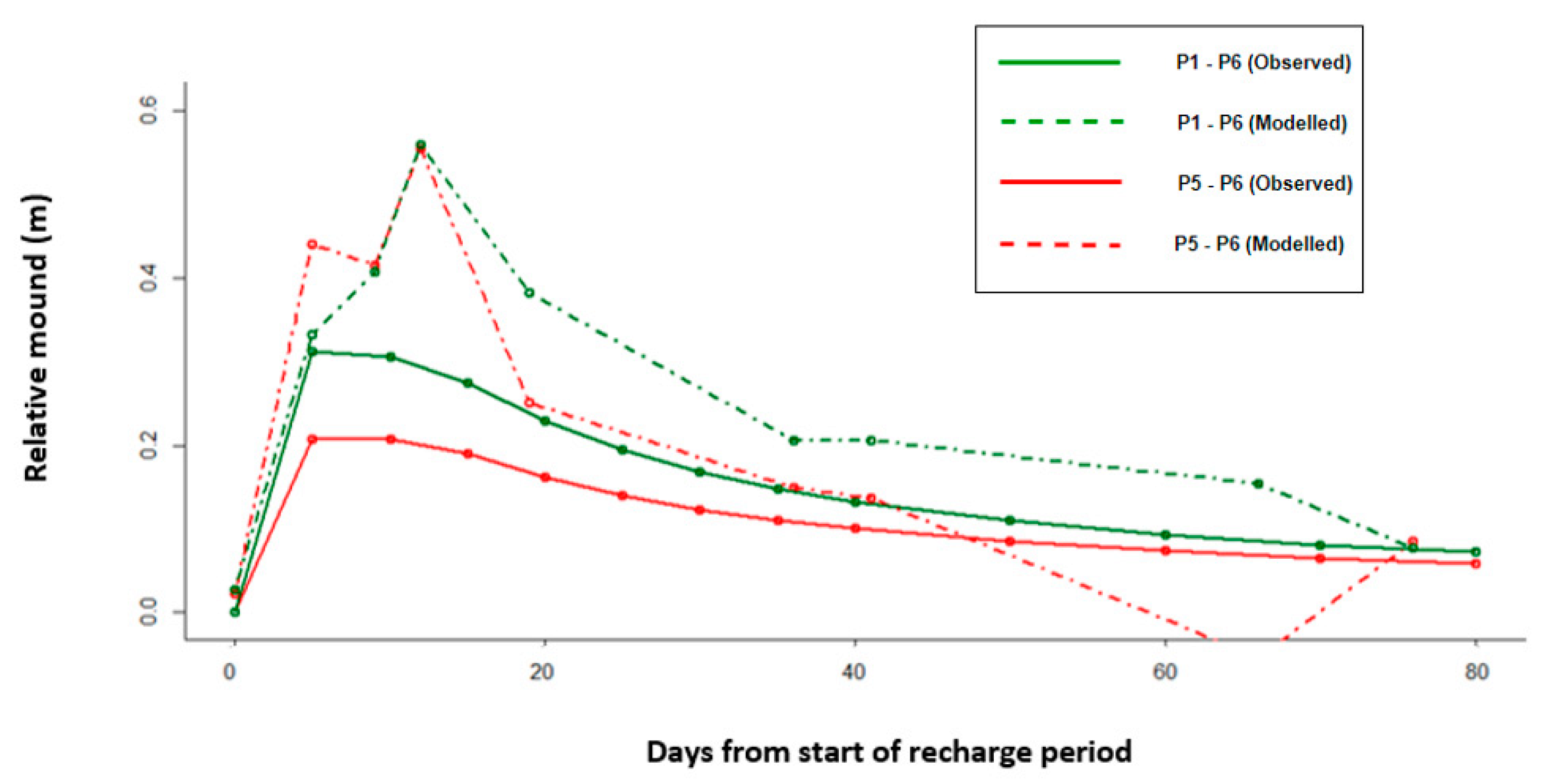
Analysis showed that the observed relative mound height was subject to noise (high fluctuations) in the years 2016 and 2018 due to a range of confounding factors (e.g., rainfall recharge, pumping and canal recharge). Only in the year 2017 was a distinct signature resembling the expected theoretical relative mound, as modelled by the Hantush model, clearly visible (Figure 4). A more distinct—though still small and with noise—signature in 2017 with respect to the signatures in 2016 and 2018 could be attributed to low rainfall during the UTFI recharge operations (Table 3) when groundwater levels naturally increased (Figure 3), limiting rainfall recharge, and the higher recharge rates in 2017 relative to those in 2016 and 2018 (Table 2). The observed relative mound in 2017 shows the expected dynamics of mound formation, with relative mound decreasing as the distance from UTFI pond increases (i.e., mound P1 > P5), and flattening and becoming insignificant as time progresses, with groundwater spreading horizontally by the end of the season. High noise in the years 2016 and 2018, and overall low relative observed and modelled mound values in all years illustrate that the impact of UTFI recharge alone on groundwater levels was small—due to the high specific yield and transmissivity of the aquifer in the pilot area—which is difficult to distinguish from fluctuations in groundwater levels due to other confounding factors.

5.3. UTFI Contribution to Recharge

Table 4 gives the estimated groundwater recharge at the village scale and the contribution of UTFI to overall recharge. Recharge in 2018 is 14% more than in both 2016 and 2017 due to higher groundwater level buildup. For years 2016, 2017 and 2018, the UTFI contribution to total recharge is 2.6%, 3.6% and 1.3% of the total recharge, respectively. Low values relative to both overall recharge is a reflection of the limited scale of the pilot relative to the village, the high recharge and the storage capacity of the groundwater systems in the region. However, the UTFI pond, with only 0.12% of the village area (indicative of the limited scale of pilot), contributed, on average, to about 2.5% of the village recharge. This shows that recharge per unit area within the pond is ~21 times higher than that occurring in other parts of the village.

5.4. Clogging Effects on Recharge

The clogging of recharge wells due to the presence of silt and clay particles in the infiltration water has been identified as one of the main challenges for the sustainable operation of managed aquifer recharge (MAR) schemes [38,39]. High silt content in the source water entering the UTFI pond reduces recharge rates by clogging recharge wells, reducing the filtering capacity of filters and silting the bottom (reducing infiltration) as the recharge season progresses.
Analysis and measurement of the particulate matter deposited in recharge wells and filters during maintenance operations showed the appearance of only physical clogging [40]. Recharge water quality, measured as total suspended solids (mg/L), in source water showed that the average total suspended solids (TSS) of source water was in the range of 260–340 mg/L over the three monsoon seasons. The range is well above the limit of 10 mg/l for which clogging has been found to be moderate-to-severe in sand and gravel aquifer types [41], and above admissible guideline values for both direct injection and indirect infiltration recharge (20–60 mg/L in EU countries [42]. However, the relationship between TSS and recharge performance is site-specific [43] and is not considered in detail here.
In addition to the measurement of the TSS of the source water, the total silt entering and, in turn, accumulated at the bottom of pond, was estimated using gridded sampling of silt depth on the pond surface at the end of the 2016 and 2017 recharge seasons [40]. For 2016 and 2017, the total accumulated silt (Table 5) was estimated to be equivalent to 3.4 mm and 5.8 mm depth of silt at the pond surface, respectively. The development of a 3–6 mm clogging layer during recharge seasons increases hydraulic resistance. This results in the much lower infiltration rate observed at the end of recharge of 14.4–17.0 mm day−1 (Table 5) in comparison to the infiltration rate that was observed at the pond bottom in 2015 after cleaning and deepening (indicator of recharge from the infiltration pond without clogging), of 106 mm day−1.
The high silt accumulation was expected as the canal also carries runoff generated by high monsoon rainfall, which consists of high particulate load [44]. For this reason, for the piloting, it was decided to start the recharge operation after the first few rainfall events, which were expected to carry the maximum sediment loads, to ensure these loads were not recharged.
In addition, regular yearly maintenance operations were carried out. In between recharge seasons, maintenance involving the cleaning of the recharge well and filters, as well as the desilting of the pond bottom, were carried out to enhance the recharge rates (Table 5).
The starting recharge rate in 2016 of 996 m3 day−1 was much lower than the initial recharge rate tested in 2015 of 3150 m3 day−1. As a result, the cleaning of recharge wells and the filter box, and the de-silting of the pond bottom took place before the 2017 recharge season. In addition to well cleaning, which removes any clogging, the process also develops a well cavity that also leads to higher recharge rates. The effect of this was clearly visible with much higher (by more than a factor of two) starting recharge rates in 2017 relative to in 2016. Prior to the 2018 recharge season, recharge wells were not cleaned, and only the pond was desilted and the filters were cleaned. Despite overall low average recharge rates, the starting recharge rate of 1978 m3 day−1 in 2018 suggests that the effect of recharge well cleaning persisted and that the recharge wells hadn’t clogged. Overall, average recharge rates post maintenance operations in 2017 increased by 44.4%, whereas in 2018, average recharge rates—despite filter cleaning and pond desiltation—were reduced by 44.5% relative to 2017, and were lower by 19.9% relative to 2016. The lower recharge rates in 2018, despite starting with high recharge rates similar to 2017, suggest the influence of factors other than clogging alone on recharge rates. Relative recharge from recharge wells and by infiltration through the basin alone is discussed in Section 6.2.1.

6. Discussion

6.1. Factors Influencing Recharge Rates

For all the years, recharge rates start at their highest values and decrease as the season progresses (Figure 5). Similar hydrologic trends have been observed at MAR sites with surface runoff containing high levels of particulate matter [38,47]. These studies tend to suggest that the reduction in recharge rates over time is a function of two major processes: (i) groundwater levels linked to rainfall and (ii) clogging linked to recharge water quality.
The increase in recharge rates post maintenance cleaning operations in 2017 shows the impact of physical clogging on recharge rates (Table 5). A high starting recharge rate in 2018, similar to that in 2017, suggests the cleaning operations post the 2017 recharge season (excluding recharge well cleaning) maintained similar clogging as in 2017. However, recharge rates in 2018 dropped steeply in line with the observed steep rise in groundwater levels, whereas in 2016 and 2017, the decline in recharge rates was gradual, in line with the rising trend in groundwater levels (Figure 5). This points to the influence of groundwater levels on recharge rates as there was no apparent difference in average source water TSS (Table 5, Figure 5). However, the limited readings of TSS add some uncertainty to the analysis, as TSS in source water show high variability associated with rainfall events.
Groundwater levels influence the recharge rates as they change the gravity head (i.e., the elevation difference between the surface water level in the pond and the groundwater level), on which gravity recharge depends [38,48]. As the groundwater levels rise during the monsoon, the gravity head decreases, resulting in declining recharge rates over the recharge season (Figure 5). The highest and lowest recharge rates in the years 2017 and 2018, respectively, are associated with the highest and lowest average available gravity heads (Table 5). Steep rises in groundwater levels towards the middle of the 2018 season brought groundwater levels up to ~2 mbgl in the nearest piezometer(P1). This shows the potential hydraulic connection taking place in between groundwater and the pond base (2.1 mbgl), which would have reduced the recharge rates [48]. This is reflected in a steep decline in recharge rates, and recharge rate values reduced to <100 m3 day−1 by the end of recharge season in 2018 in comparison to end of season recharge rates of ~300 m3 day−1 in 2017 and 2016, where groundwater levels remained deeper than 3 m. The pond water level remained above the minimum threshold level for recharge (Figure 5). No direct correlation between recharge rates and pond levels could be made out, which shows that the pond water level, which has a source from the canal, is not the limiting factor in recharge rates, and that clogging and the groundwater level beneath the pond when this becomes hydraulically connected to the pond remain the leading factors influencing recharge rates.

UTFI Recharge Variation Implications for Flood Mitigation

The high inter-year variation of recharge rates carries high significance for the dual aims of UTFI in the region: flood mitigation and enhancing groundwater storage. UTFI recharge is highest in low rainfall years (61,969 m3 in 2017 with rainfall of 905 mm) and lowest in high rainfall years (26,207 m3 in 2018 with rainfall of 1811 mm). This is because high rainfall years lead to high groundwater levels, thereby decreasing the available gravity head, which reduces UTFI recharge rates. At the same time, high rainfall intensity years, such as 2018, may also reduce the number of recharge days, which are already constrained by the monsoon season.
Thus, on one hand, higher recharge in low rainfall years shows that UTFI could play an important positive role in addressing groundwater storage depletion in dry years when recharge is limited. However, lower recharge in wet years, which are also the years when more intense flooding is expected to take place, shows the diminishing returns of UTFI if upscaled specifically for flood mitigation. This influence of rainfall and groundwater levels is critical and needs to be taken into consideration for planning purposes when flood mitigation is a central objective.
Several multi-year studies analyzing MAR recharge performance in other parts of India have observed recharge behaviors quite different to those in this study. Those studies indicate high recharge in high rainfall years and vice versa [19,49]. Recharge-rainfall relationships in those cases would appear to be characterized by a different set of limiting factors for recharge. For example, in the case of check dam recharge reported by [19,49], all of the monitored check dams showed higher recharge in high rainfall years, as low rainfall years result in less recharge due to low inflow into the dams. However, study [19] was later extended to include a wetter year [50], where recharge was observed to be less than for the average year, indicating recharge limited by aquifer capacity. This is similar to the UTFI pilot case where source water was not a limitation (supplied by a canal at flow rates far higher than what could be recharged). Instead, recharge is limited by the available gravity head and the infrastructure performance.

6.2. Performance of the UTFI Pilot

6.2.1. Comparing Recharge Wells to the Infiltration Pond

The pilot chose to employ sub-surface recharge methods using recharge wells to maximize recharge rates to overcome land availability constraints, as the region is one of the most densely populated places in the world [51]. To assess the performance, UTFI system recharge rates (RUTFI) were compared against infiltration rates observed from the pond bottom alone. Recharge rates from the base of the pond were estimated in two ways at two different times: first, during 6 h ring infiltration tests during preliminary recharge testing in 2015, and later on, during recharge operations, by observing the time taken for the dead storage to empty. Assuming the same decreasing temporal trends in infiltration from the pond bottom as overall recharge rates, rates from the infiltration ring are comparable with recharge rates at the start of season. The decline in dead storage (corrected for evaporative losses), can be compared with the end of season recharge rates.
The average infiltration rate from the pond bottom in 2015 after cleaning and deepening the pond (an indicator of recharge from the infiltration pond only) was 106 mm day−1. In comparison, the UTFI system recharge rate at the start of season was 379 mm day−1 in 2016, 933 mm day−1 in 2017 and 752 mm day−1 in 2018; these rates were, on average, higher by factors of 3.6, 8.8 and 7.1, respectively. Similarly, infiltration from the pond bottom at the end of the pilot was 14.4, 17.0 and 16.2 mm day−1 in 2016, 2017 and 2018, respectively (Table 5). In comparison, end-of-season UTFI recharge rates for the corresponding years were 104.4, 110.1 and 32.4 mm day−1, which were, on average, higher by factors of 7.2, 6.5 and 2.0 respectively. These high recharge rates justify the use of sub-surface methods, without which far lower volumes would have been recharged.

6.2.2. Comparing UTFI to Comparable Studies in the Region

The limited existing studies of MAR using sub-surface methods in the Indo-Gangetic Plains having similar aquifer characteristics as the study area were reviewed to compare UTFI performance. In one study in the neighboring state of Haryana, recharge wells were used to recharge canal water during the rainy season (July–October), with reported average recharge rates from a single well of 794–989 m3 day−1 in the first year with no typical trend, whereas in the second year, recharge rates reduced from 1088 m3 day−1 at the start to 798 m3 day−1 by the end of the season [14]. In other studies from an alluvial area in the state of Punjab, all of which used canal water as the source, reported recharge rates ranged from 302 to 3784 m3 day−1 [15], and from 588 to 1766 m3 day−1 well−1 in three case studies reported by [16]. The Master Plan for MAR in India gave an expected average design recharge rate from a recharge shaft in alluvial areas of Uttar Pradesh of 1000 m3 day−1, running on about 60 operational days during monsoon [52]; however, no supporting data are provided on how these estimates were derived.
Large differences in recharge rates among the studies presented above point to the number of factors influencing recharge rates such as the aquifer characteristics, groundwater levels, source water, design and methods used to estimate recharge. Contrasts in system design ranged from pressure injection in Ghaggar, Punjab [15] to a battery of 20 recharge wells installed in 20 trenches in Patiala [16]. The depth of recharge wells ranged from 26 to 81 m, and groundwater levels were >10–15 m, in comparison to the shallow groundwater levels in the UTFI pilot case (2–7 m). Given the large number of differences and the general lack of studies in the region that investigated recharge performance comprehensively over multi-year time periods, along with the limited details on monitoring provided, any systematic comparisons are difficult.

6.3. Dependence of Aquifer Type on Groundwater Mounding

Most MAR case studies in India report a visible increase in groundwater levels or longer availability of water in wells [17,18]. For example, [18] reviewed six case studies, all in hard rock areas, which reported increases in groundwater levels of up to 4–7 m due to MAR interventions. In contrast, for the UTFI pilot, modelled and observed mounds are small (~0.4–0.8 m). In addition, the expected mound is difficult to distinguish from background water level variations.
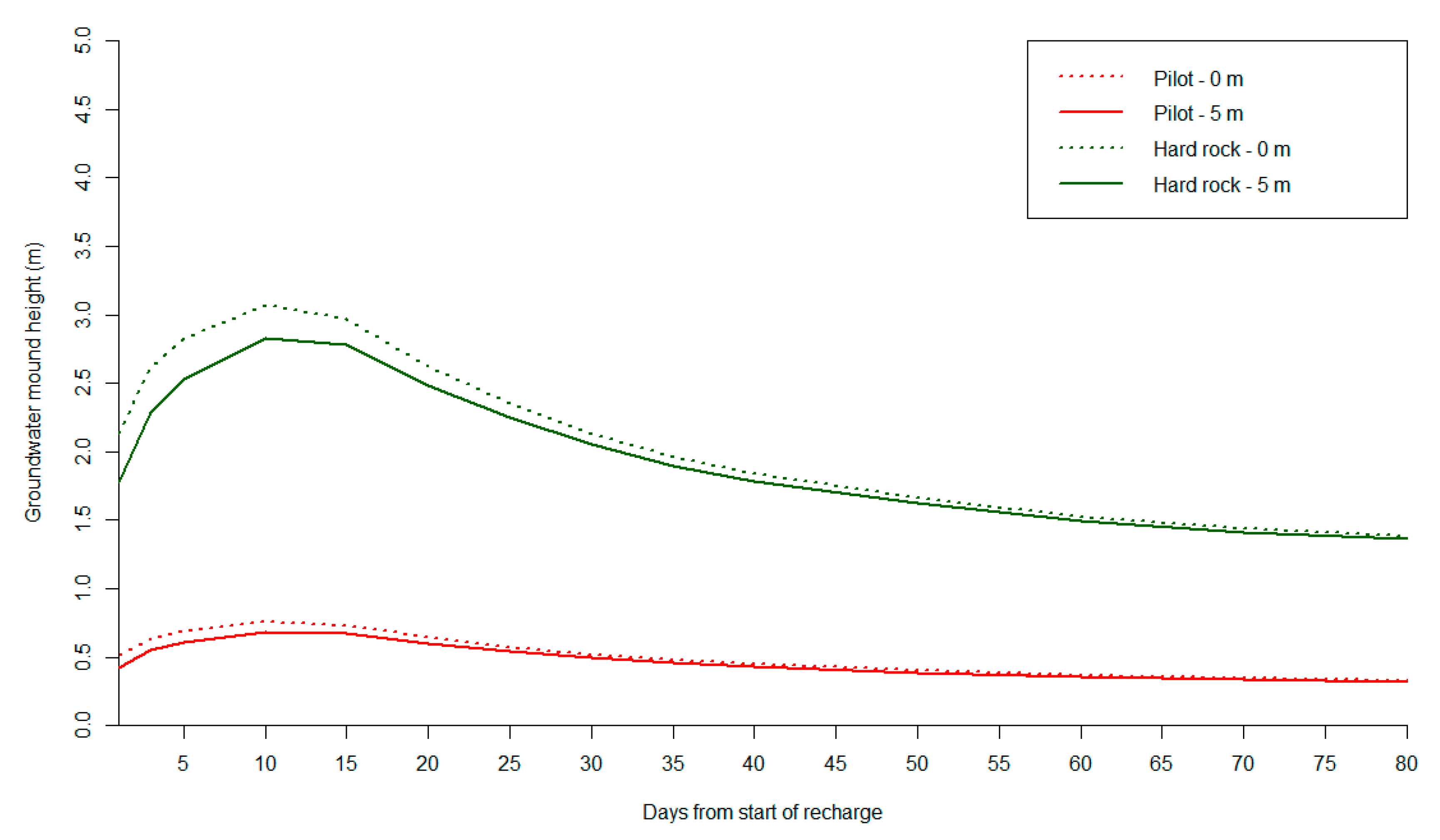
The low mound formation observed during the pilot relative to high values reported in other MAR studies in India, most of which come from hard rock areas, reflects the contrast in hydrogeological characteristics such as porosity, transmissivity and lithology, and the thickness of the aquifer. To analyze the expected difference due to hydrogeology, the Hantush solution was run with typical hard rock aquifer (basaltic) characteristics (a hydraulic conductivity (k) of 5 m day−1 and a specific yield (Sy) of 0.02) [35] and compared with the UTFI pilot site (Figure 6). The difference in mound height is apparent, with hard rock aquifers showing a mound height much higher than the pilot (an average of 2.8 m and 2.1 m in hard rock vs. 0.7 m and 0.5 m in the pilot case) at distances of 0 m (i.e., the center of the pond) and at 5 m (i.e., P1), respectively for the same recharge volume. In the Hantush model, mound height was calculated from the center of the rectangular basin in the x-direction with the basin edge at a distance of 17.5 m (i.e., (35 m)/2). Therefore, a piezometer at a distance of 5 m from the edge of pond is at a distance of 5 + 17.5 = 22.5 from the center of the rectangular basin. The contrast with the hard rock aquifers is a reflection of high aquifer transmissivity and specific yield of the alluvial aquifer in the village. Though this is as expected, it underlies that the same recharge performance would have had a very different impact on groundwater levels, depending on the hydrogeological conditions. In alluvial aquifers, as is the case in the UTFI pilot, the storage changes are more subdued and would require detailed monitoring to discern the change in groundwater levels in response to recharge.

6.4. Scaling up of UTFI

The scaling up of UTFI to the basin scale requires a sound assessment of the availability of flows for recharge, the capacity of available groundwater storage to store runoff and the demand for recharge water. In addition, studies on the costs and benefits are required to ascertain the economic rationale for upscaling. Previous research by [11] has shown that the average monsoon runoff in the Ramganga basin during the monsoon months is 5782 million m3. Recharging 10–50% of these runoff volumes can reduce flooding (with a 5 year return period) by 5–27%, increase groundwater recharge by 11–56%, and increase groundwater levels, on average, by 1.2–4.6 m with respect to a no-UTFI scenario. Assessment of the economic benefits (based on increasing crop intensity by using recharge water) by [53] shows that upscaling would require huge capital investment in infrastructure, but on average have a benefit to cost ratio of >1.
However, the above study is based on major assumptions [53], nor does it consider the actual performance of the UTFI system that this pilot study explored. However, one UTFI pilot could not be considered representative of the entire basin, but can help to identify lessons that are critical when developing any upscaling strategy. For example, the insights on diminishing UTFI recharge rates during high rainfall years, due to high recharge leading to hydraulic connection, warrant the need to look more critically at the available groundwater storage and the variability in recharge rates. The need for routine operation and maintenance must be clearly accounted for while doing any economic analysis. In addition, any scaling up would require the consideration of socioeconomic, institutional and related issues, which are not analyzed in this study, but are touched upon in [20,21].

7. Conclusions

The first UTFI pilot trial in the Indo-Gangetic Plain in India was capable of recharging an average annual volume of 44,000 m3 with the recharge volume over three years varying from 26,000 to 62,000 m3 (i.e., 430 to 775 m3 day−1 during the recharge periods). These volumes are 5.0–11.8 times the total storage capacity of the pond and would be sufficient to irrigate 8–18 hectares of rabi crop. High intra-year variation, reflected in recharge rate reductions ranging from 72.4% to 95.7% relative to the starting conditions, was observed. This is linked to the roles of: (a) source water quality (TSS of 260–340 mg/L) leading to clogging, and (b) groundwater levels influencing gravity heads as the recharge season progresses, and hydraulic connection further reducing recharge in the wetter year (2018) when recharge from other sources is high. Annual maintenance activities involving desilting basins, and cleaning filters and recharge wells appear to be effective in controlling clogging and restoring recharge rates. Overall, the UTFI design achieved much higher recharge rates (2–9 times) than what would have been achieved from village ponds alone through infiltration. The results show that the relative mounding in nearby wells w.r.t to the reference well at 100 m distance due to UTFI is limited, due to the high specific yield and transmissivity of the alluvial aquifer, and is influenced by a range of confounding factors that make the delineation of small mound heights difficult. The results provide the first systematic, multi-year assessment of the performance of UTFI systems at the individual pond scale in the flood prone, intensively irrigated, alluvial aquifer regions of the Indo-Gangetic Plain.

Author Contributions

Conceptualization, M.F.A. and P.P.; Data curation, M.F.A. and N.S.; Formal analysis, M.F.A.; Funding acquisition, P.P.; Investigation, M.F.A., P.P. and N.S.; Methodology, M.F.A. and P.P.; Project administration, A.S. and P.P.; Supervision, P.P. and A.S.; Visualization, M.F.A.; Writing—original draft, M.F.A.; Writing—review & editing, P.P. All authors have read and agree to the published version of the manuscript.

Funding

This research received no external funding.

Acknowledgments

It was undertaken as part of the CGIAR Research Program on Climate Change, Agriculture and Food Security (CCAFS). It also contributes to the CGIAR Research Program on Water, Land and Ecosystems (WLE). The contributions and support provided by IWMI colleagues including Prasun Gangopadhyay (IWMI), Krishi Vigyan Kendra (KVK), Rampur and the Central Soil Salinity Research Institute (CSSRI), Lucknow for carrying out UTFI pilot are gratefully acknowledged. Critical reviews by two anonymous reviewers and the editor of this Special Issues helped to improve the quality of this paper.

Conflicts of Interest

The authors declare no conflict of interest.

References

  1. Hall, J.; Grey, D.; Garrick, D.; Fung, F.; Brown, C.; Dadson, S.; Sadoff, C.W. Water Security. Coping with the curse of freshwater variability. Science 2014, 346, 429–430. [Google Scholar] [CrossRef]
  2. Hoekstra, A.; Mekonnen, M.; Chapagain, A.; Mathews, R.; Richter, B. Global Monthly Water Scarcity: Blue Water Footprints versus Blue Water. PLoS ONE 2012, 7, e32688. [Google Scholar] [CrossRef] [PubMed]
  3. FAO. The Impact of Disasters on Agriculture and Food Security; Food and Agriculture Organization of the United Nations (FAO): Rome, Italy, 2015. [Google Scholar]
  4. United Nations. Climate Change and Water: UN-Water Policy Brief; United Nations: Geneva, Switzerland, 2019. [Google Scholar]
  5. IPCC. Summary for Policymakers. In Managing the Risks of Extreme Events and Disasters to Advance Climate Change Adaptation, A Special Report of Working Groups I and II of the Intergovernmental Panel on Climate Change; Field, C.B., Barros, V., Stocker, T.F., Qin, D., Dokken, D.J., Ebi, K.L., Mastrandrea, M.D., Mach, K.J., Plattner, G.-K., Allen, S.K., et al., Eds.; Cambridge University Press: Cambridge, UK; New York, NY, USA, 2012; pp. 1–19. [Google Scholar]
  6. Van der Gun, J. Groundwater and Global Change: Trends, Opportunities and Challenges; UNESCO: Paris, France, 2012. [Google Scholar]
  7. Döll, P.; Schmied, H.M.; Schuh, C.; Portmann, F.T.; Eicker, A. Global-scale assessment of groundwater depletion and related groundwater abstractions: Combining hydrological modeling with information from well observations and GRACE satellites. Water Resour. Res. 2014, 50, 5698–5720. [Google Scholar] [CrossRef]
  8. Pavelic, P.; Brindha, K.; Amarnath, G.; Eriyagama, N.; Muthuwatta, L.; Smakhtin, V.; Gangopadhyay, P.K.; Malik, R.P.S.; Mishra, A.; Sharma, B.R.; et al. Controlling Floods and Droughts through Underground Storage: From Concept to Pilot Implementation in the Ganges River Basin; IWMI Research Report; International Water Management Institute: Colombo, Sri Lanka, 2015; Volume 165, 33p. [Google Scholar] [CrossRef] [Green Version]
  9. Brindha, K.; Pavelic, P. Identifying priority watersheds to mitigate flood and drought impacts by novel conjunctive water use management. Environ. Earth Sci. 2016, 40, 407–431. [Google Scholar] [CrossRef]
  10. Pavelic, P.; Srisuk, K.; Sarap, P.; Nadee, S.; Pholkern, K.; Chusanathas, S.; Sitisak, M.; Theerasak, T.; Teerawash, I.; Vladimir, S. Balancing-out floods and droughts: Opportunities to utilize floodwater harvesting and groundwater storage for agricultural development in Thailand. J. Hydrol. 2012, 470–471, 55–64. [Google Scholar] [CrossRef]
  11. Chinnasamy, P.; Muthuwatta, L.; Eriyagama, N.; Pavelic, P.; Lagudu, S. Modeling the potential for floodwater recharge to offset groundwater depletion: A case study from the Ramganga basin, India. Sustain. Water Resour. Manag. 2018. [Google Scholar] [CrossRef]
  12. Khan, R.M.; Voss, C.I.; Yu, W.; Michael, H.A. Water resources management in the Ganges Basin: A comparison of three strategies for conjunctive use of groundwater and surface water. Water Resour. Manag. 2014, 28, 1235–1250. [Google Scholar] [CrossRef]
  13. MacDonald, A.M.; Bonsor, H.C.; Taylor, R.; Shamsudduha, M.; Burgess, W.G.; Ahmed, K.M.; Mukherjee, A.; Zahid, A.; Lapworth, D.; Gopal, K.; et al. Groundwater Resources in the Indo-Gangetic Basin: Resilience to Climate Change and Abstraction; British Geological Survey Open Report OR/15/047; British Geological Survey: Nottingham, UK, 2015. [Google Scholar]
  14. Kaledhonkar, M.J.; Singh, O.P.; Ambast, S.K.; Tyagi, N.K.; Tyagi, K.C. Artificial groundwater recharge through recharge tube wells: A case study. J. Inst. Eng. (India) 2003, 84, 5. [Google Scholar]
  15. Sakthivadivel, R. The groundwater recharge movement in India. In The Agricultural Groundwater Revolution: Opportunities and Threats to Development; Giordano, M., Villholth, K., Eds.; CAB International Publishing: Colombo, Sri Lanka, 2007. [Google Scholar]
  16. Gupta, S. Groundwater Management in Alluvial Areas, Incidental Paper. CGWB, Ministry of Water Resources, Government of India; 2011. Available online: http://cgwb.gov.in/documents/papers/incidpapers/Paper%2011-%20sushil%20gupta.pdf (accessed on 12 November 2019).
  17. Glendenning, C.J.; van Ogtrop, F.F.; Mishra, A.K.; Vervoort, R.W. Balancing watershed and local scale impacts of rain water harvesting in India: A review. Agric. Water Manag. 2012, 107, 1–13. [Google Scholar] [CrossRef]
  18. Prathapar, S.; Dhar, S.; Rao, G.T.; Maheshwari, B. Performance and impacts of managed aquifer recharge interventions for agricultural water security: A framework for evaluation. Agric. Water Manag. 2015, 159, 165–175. [Google Scholar] [CrossRef]
  19. Dashora, Y.; Dillon, P.; Maheshwari, B.; Soni, P.; Dashora, R.; Davande, S.; Purohit, R.C.; Mittal, H.K. A simple method using farmers’ measurements applied to estimate check dam recharge in Rajasthan, India. Sustain. Water Resour. Manag. 2018, 4, 301–316. [Google Scholar] [CrossRef]
  20. Reddy, V.R.; Pavelic, P.; Hanjra, M.A. Underground Taming of Floods for Irrigation (UTFI) in the river basins of South Asia: Institutionalizing approaches and policies for sustainable water management and livelihood enhancement. Water Policy 2017, 20, wp2017150. [Google Scholar] [CrossRef]
  21. Reddy, V.R.; Rout, S.K.; Shalsi, S.; Pavelic, P.; Ross, A. Managing underground transfer of floods for irrigation: A case study from the Ramganga Sub-Basin (Ganges Basin), India. J. Hydrol. 2020. [Google Scholar] [CrossRef]
  22. Census of India. District Census Handbook, Rampur; Village and town wise primary census abstract; Directorate of Census Operations: Uttar Pradesh, India, 2011. [Google Scholar]
  23. DoES. Total Area and Classification of Area in Each District of Uttar Pradesh State for the Year Ending 2014-15 (Hectare); Special Data Dissemination Standard Division, Directorate of Economics & Statistics (DoES), Ministry of Agriculture and Farmers Welfare; Govt. of India: New Delhi, India, 2015. Available online: https://aps.dac.gov.in/LUS/Index.htm (accessed on 22 October 2019).
  24. Government of Uttar Pradesh. District Disaster Management Plan; DDMA: Rampur, India, 2010. [Google Scholar]
  25. Government of Uttar Pradesh. District Disaster Management Plan; DDMA: Rampur, India, 2013. [Google Scholar]
  26. Government of Uttar Pradesh. Report of Officer-in-Charge, District Flood Protection and Relief; Government of Uttar Pradesh: Rampur, India, 2015. [Google Scholar]
  27. Government of Uttar Pradesh. District Statistical Handbook; Government of Uttar Pradesh: Rampur, India, 2014. [Google Scholar]
  28. Tripathi, A.K. District Ground Water Brochure of Rampur District; U.P. Central Ground Water Board (CGWB): Rampur, India, 2009. [Google Scholar]
  29. CGWB. Dynamic Groundwater Resources of India (As on 31st March, 2013); Central Ground Water Board, Ministry of Water Resources, River Development & Ganga Rejuvenation Government of India: Faridabad, India, 2017. [Google Scholar]
  30. Bouwer, H. Artificial recharge of groundwater: Hydrogeology and engineering. Hydrogeol. J. 2002, 10, 121–142. [Google Scholar] [CrossRef] [Green Version]
  31. Hantush, M.S. Growth and decay of groundwater-mounds in response to uniform percolation. Water Resour. Res. 1967, 3, 227–234. [Google Scholar] [CrossRef] [Green Version]
  32. Yihdego, Y. Simulation of Groundwater Mounding Due to Irrigation Practice: Case of Wastewater Reuse Engineering Design. Hydrology 2017, 4, 19. [Google Scholar] [CrossRef] [Green Version]
  33. Poeter, E.P.; McCray, J.E. Modeling water table mounding to design cluster and high-density wastewater soil absorption systems. J. Hydrol. Eng. 2008, 13, 702–709. [Google Scholar] [CrossRef]
  34. Carleton, G.B. Simulation of Groundwater Mounding Beneath Hypothetical Stormwater Infiltration Basins; U.S. Geological Survey: Reston, VA, USA, 2010. [Google Scholar]
  35. Sharma, B.; Gulati, A.; Mohan, G.; Manchanda, S.; Ray, I.; Amarasinghe, U. Water Productivity Mapping of Major Indian Crops; NABARD and ICRIER: New Delhi, India, 2018. [Google Scholar]
  36. MoWR, RD & GR, GoI. Ministry of Water Resources, River Development & Ganga Rejuvenation Government of India. In Report of the Ground Water Resource Estimation Committee (GEC-2015); MoWR, RD & GR, GoI: New Delhi, India, 2017. [Google Scholar]
  37. Healy, R.W.; Cook, P.G. Using groundwater levels to estimate recharge. Hydrogeol. J. 2002, 10, 91–109. [Google Scholar] [CrossRef]
  38. Holländer, H.M.; Mull, R.; Panda, S.N. A concept for managed aquifer recharge using ASR-wells for sustainable use of groundwater resources in an alluvial coastal aquifer in Eastern India. Phys. Chem. Earth Parts A/B/C 2009, 34, 270–278. [Google Scholar] [CrossRef]
  39. Martin, R. (Ed.) Clogging Issues Associated with Managed Aquifer Recharge Methods; IAH Commission on Managed Aquifer Recharge: Adelaide, Australia, 2013. [Google Scholar]
  40. CSRRI. Technological Assessment of Underground Taming of Floods for Irrigation; Progress report prepared for the International Water Management Institute for project: Piloting and Up-scaling an Innovative Approach for Mitigating Urban Floods and Improving Rural Water Security in South Asia; ICAR-Central Soil Salinity Research Institute, Regional Research Station: Lucknow, India, 2018. [Google Scholar]
  41. NRMMC, ERHC and NHMRC. Australian Guidelines for Water Recycling: Managed Aquifer Recharge (National Water Quality Management Strategy No. 24); Natural Resource Management Ministerial Council (NRMMC), Environment Protection and Heritage Council (ERHC) and National Health and Medical Research Council (NHMRC): Canberra, Australia, 2009. [Google Scholar]
  42. Miret, M.; Vilanova, E.; Molinero, J.; Sprenger, C. The Management of Aquifer Recharge in the European Legal Framework (DEMEAU Project, European Commission). Available online: https://demeau-fp7.eu/sites/files/D121%20legal%20framework%20and%20MAR%20DEMEAU%20project_1.pdf (accessed on 12 October 2019).
  43. Hutchinson, A.; Milczarek, M.; Banerjee, M. Clogging phenomena related to surface water recharge facilities. In Clogging Issues Associated with Managed Aquifer Recharge Methods; Martin, R., Ed.; IAH Commission on Managed Aquifer Recharge: Adelaide, Australia, 2013; pp. 95–106. [Google Scholar]
  44. Kumar, A.; Bahadur, Y. Water quality of River Kosi and Rajera system at Rampur (India): Impact Assessment. J. Chem. 2012, 2013, 618612. [Google Scholar] [CrossRef] [Green Version]
  45. Kohli, A.; Frenken, K. Evaporation from Artificial Lakes and Reservoirs (FAO AQUSTAT Reports); FAO: Rome, Italy, 2015. [Google Scholar]
  46. IWP. India Water Portal Met Data [WWW Document]. Available online: https://www.indiawaterportal.org/met_data/ (accessed on 22 November 2019).
  47. Dillon, P.J.; Vanderzalm, J.; Page, D.; Barry, K.; Gonzalez, D.; Muthukaruppan, M.; Hudson, M. Analysis of ASR clogging investigations at three Australian ASR sites in a Bayesian context. Water 2016, 8, 442. [Google Scholar] [CrossRef] [Green Version]
  48. Dillon, P.J.; Liggett, J.A. An ephemeral stream aquifer interaction model. Water Resour. Res. 1983, 19, 621–626. [Google Scholar] [CrossRef]
  49. Glendenning, C.J.; Vervoort, R.W. Hydrological impacts of rainwater harvesting (RWH) in a case study catchment: The Arvari River, Rajasthan, India. Part 1: Field-scale impacts. Agric. Water Manag. 2010, 98, 331–342. [Google Scholar] [CrossRef]
  50. Dashora, Y.; Dillon, P.; Maheshwari, B.; Soni, P.; Mittal, H.; Dashora, R.; Singh, P.K.; Purohit, R.C.; Katara, P. Hydrologic and cost benefit analysis at local scale of streambed recharge structures in Rajasthan (India) and their value for securing irrigation water supplies. Hydrogeol. J. 2019, 27, 1889–1909. [Google Scholar] [CrossRef] [Green Version]
  51. FAO. Irrigation in Southern and Eastern Asia in Figures—AQUASTAT Survey—2011. 2011. Available online: http://www.fao.org/nr/water/aquastat/basins/gbm/gbm-CP_eng.pdf (accessed on 12 November 2019).
  52. GoI. Master Plan. for Artificial Recharge to Ground Water in India; Ministry of Water Resources and Central Groundwater Board, Government of India: New Delhi, India, 2013. [Google Scholar]
  53. Alam, M.F.; Pavelic, P. Underground Transfer of Floods for Irrigation (UTFI): Exploring the Potential at the Global Scale; IWMI Research Report; International Water Management Institute: Colombo, Sri Lanka, in press.
Figure 1. The location of the Underground Transfer of Floods for Irrigation (UTFI) pilot study area in Jiwai Jadid village, Rampur District, Uttar Pradesh, India.
Water 12 01028 g001
Figure 2. (A): The location of the UTFI pond and the installed piezometers at the pilot site (P1 to P7 = piezometers); (B): The completed UTFI pilot site; (C): A simplified vertical cross section of the UTFI pond; (D): A schematic of the pond showing the locations of recharge wells within the pond (RW1 to RW10 = recharge wells).
Water 12 01028 g002
Figure 3. Observed groundwater levels (depth below ground level in mbgl) for piezometers and recharge wells (RW1 and RW10) with pond water levels over the period from January 2016 to November 2018. The grey shaded areas represent the periods of UTFI recharge operations. The dashed line shows the minimum pond level for which well recharge takes place.
Water 12 01028 g003
Figure 4. Observed and modelled relative mound heights, relative to P6 that was used as the reference piezometer, for piezometers at P1 (i.e., P1–P6) and P5 (i.e., P5–P6) for the year 2017.
Water 12 01028 g004
Figure 5. UTFI recharge rates, the groundwater level of P1 (meters below ground level (mbgl)), the pond water level (mblg) and the TSS of source water UTFI from 2016 to 2018. The dashed line shows the minimum pond level for which well recharge takes place. Text boxes show the desilting activities. The grey shaded areas represent the periods of recharge.
Water 12 01028 g005
Figure 6. Modelled mound heights at the center of pond (0 m) and P1 (5 m) for the pilot (Sy = 0.1 and k = 20 m day−1) and general hard rock aquifers (Sy = 0.02 and k = 5 m day−1) under the observed UTFI recharge rates of the year 2017.
Water 12 01028 g006
Table 1. The monitored parameters, methods of measurement and frequencies.
ParameterMeasurement MethodFrequency
Groundwater levelsNine piezometers were installed (Figure 2). All groundwater levels of piezometers are given relative to the reference point, RW1 (in mbgl).Measured weekly using a portable water level meter during recharge operations, and every 2 weeks during non-recharge periods
UTFI pond infiltration rate(A) Single ring infiltration test up to 8 h was conducted at the bottom of pond at four locations after pond cleaning/development
(B) Days taken for pond dead storage to dry out after stopping recharge operations
(A) 6 h test at 4 locations at 45 cm depth on the 11 and 18 September, 2015
(B) At the end of the recharge operations each year
RainfallRain gauge at Krishi Vigyan Kendra (KVK), Rampur city, situated approximately 20 km from the pilot siteDaily from 24 June 2016
Canal water levelsMeasuring scale was marked in canal wall near road bridgeDaily basis during the recharge operation and at 15 day intervals during non-recharge periods
UTFI pond storage volumeRelationship between depth of water in pond and volume of water in pond was developedAfter pond development
UTFI Pond water level measurementMeasuring scale was marked at recharge well (RW1 in Figure 2) to record pond water level. All depths are relative to the RW1 reference point.Pond water level was recorded on a daily basis during the recharge operations
Source water silt contentWater samples analyzed for total solid solids (TSS);
Mass of silt accumulated at pond bottom after recharge seasons (tonnes)
Monthly;
After recharge season of 2016 and 2017
Socio-economic surveySocio-economic survey of 120 farmers within a 1 km radius of the UTFI siteAt the start of the pilot trial in 2016
Table 2. UTFI recharge volumes (VUTFI) and recharge rates (RUTFI) for 2016, 2017 and 2018.
YearStart Date–End DateNumber of Recharge Days aVUTFI (m3)RUTFI (m3 day−1) (mm day−1) b
201615 July–7 October8545,070537 (204)
201717 July–5 October7861,969775 (295)
20186 August–6 October6226,207430 (164)
Average-7544,415580 (221)
a During monsoon season after the recharge period started, despite dry periods, the pond had water above dead storage height, so recharge continued. b Recharge rate in mm day−1 = ((Recharge rate m3 day−1)/(pond area m2)) × 1000.
Table 3. Rainfall and rainy days for 2016, 2017 and 2018.
ParameterTime Period201620172018
Rainfall (mm)Annual8579051812
Monsoon (28 June–22 September)8578741708
Recharge period737472992
Rainy daysAnnual232227
Monsoon (28 June–22 September)232022
Recharge period14812
Table 4. Annual village and UTFI recharge with recharge components (Equation (4)) for 2016–2018.
(×103 m3)
YearΔGWS aVAmonsoonbVVillageVUTFIUTFI (% of Recharge)
20165811158173945.072.6
20175831158174161.973.6
20188351158199326.211.3
a ΔGWS (m3) = ΔH × Sy × Avillage with ΔH for 2016, 2017 and 2018 is 2.74 m, 2.75 and 3.95 m, respectively; Sy = 0.1; Avillage = 212 hectares. b Gross irrigation applied for paddy in the kharif season in western Uttar Pradesh is 1100 mm [37]. Considering 45% return flow, net irrigation is 605 mm. Considering a crop area of village of 191.2 ha and 100% irrigation by GW, VAmonsoon (m3) = (605/1000) × (191.5 × 10000). Irrigation applied is not scaled to rainfall, as irrigation is influenced by both the distribution of rainfall and farmers’ decisions on the sowing date. For this reason, only the average irrigation applied is used.
Table 5. A summary of groundwater levels, recharge rates (RUTFI) and maintenance operations over the recharge season from 2016–2018.
YearRUTFI (m3 day−1)Recharge Well CleaningFilter CleaningDesilting Pond BottomGravity Head for Recharge (m) aAvg. water Quality Entering Pond (TSS: mg/L) bTotal Silt Accumulated c (Tonnes)Days Taken for Dead Storage to Dry dEnd Season Infiltration Rate (mm day−1) e
StartEndAvg.
2016996274537NoNoNo4.034012.25514.4
20172499289775yesyesYes4.726021.24817.0
2018197885430NoYesYes3.5282-5016.2
a Taken as elevation difference between the surface water level in the pond and the elevation of the water table in the nearest piezometer (P1). b Number of readings were limited: monthly in 2016 and 2018; much more in 2017. c Estimated based on silt load accumulated at the pond bottom, determined based on gridded sampling. d Total number of days taken for the pond to dry out from 1 m of dead storage (no recharge of recharge wells. Indicated by the last pond water level reading in Figure 5) by infiltration + evaporation. e Estimated from the time taken for dead storage to dry (dead storage (volume)/days) and subtracting the evaporation rate calculated using ETc = Kc × ETO and taking Kc = 1 for open water [45]. Reference evapotranspiration (ETO) is taken as the average of the months of October and November) and is 3.82 mm day−1 [46].