Article

Lessons Learnt from the Long-Term Management of a Large (Re)constructed Wetland, the Kis-Balaton Protection System (Hungary)

1
MTA-BME Water Research Group, H-1111 Budapest, Hungary
2
School of Soil and Water Conservation, Beijing Forestry University, Beijing 100083, China
3
Department of Sanitary and Environmental Engineering, Budapest University of Technology and Economics, H-1111 Budapest, Hungary
*
Author to whom correspondence should be addressed.
Water 2020, 12(3), 659; https://doi.org/10.3390/w12030659
Submission received: 13 January 2020 / Revised: 25 February 2020 / Accepted: 26 February 2020 / Published: 29 February 2020
(This article belongs to the Special Issue Monitoring, Modelling and Management of Water Quality)

Abstract

:
Environmental management decisions should be made based on solid scientific evidence that relies on monitoring and modeling. In practice, changing economic, societal, and political boundary conditions often interfere with management during large, long, and complex projects. The result may be a sub-optimal development path that may finally diverge from the original intentions and be economically or technically ineffective. Nevertheless, unforeseen benefits may be created in the end. The Kis-Balaton wetland system is a typical illustration of such a case. Despite tremendous investments and huge efforts put in monitoring and modeling, the sequence of decisions during implementation can hardly be considered optimal. We use a catchment model and a basic water quality model to coherently review the impacts of management decisions during the 30-year history. Due to the complexity of the system, science mostly excelled in finding explanations for observed changes after the event instead of predicting the impacts of management measures a priori. In parallel, the political setting and sectoral authorities experienced rearrangements during system implementation. Despite being expensive as a water quality management investment originally targeting nutrient removal, the Kis-Balaton wetland system created a huge ecological asset, and thereby became worth the price.

1. Introduction

Water resources management—just like any other type of decision-making—should principally rely on rationality and scientific evidence [1,2]. In rational decision theories, scientific knowledge influences both the objectives of management and the concepts of how these could be achieved [3]. Scientific influence is more explicit on the latter through monitoring and mathematical modelling. According to the best available management practice, decisions should be based on careful analysis of system behavior and on model-based forecasts of system alterations driven by external impacts [1]. However, decisive boundary conditions for management include the political context, and long-term shifts in societal attitudes that arise from a multitude of often contradictory interests of various stakeholder groups [4]. These conditions determine priorities, which may or may not comply with the natural operation mode of the managed system. In any case, changing priorities gradually alter the objectives of management. Large-scale management structures, which need large investment costs and have long lifetimes are prone to the consequences of changing priorities. This first of all applies to structures designed for relatively soft management purposes, such as water quality protection. In this paper we demonstrate how the interplay of rationality and changing environmental and sociopolitical boundary conditions may distort the outcomes of management using the case of the Kis-Balaton Protection System.

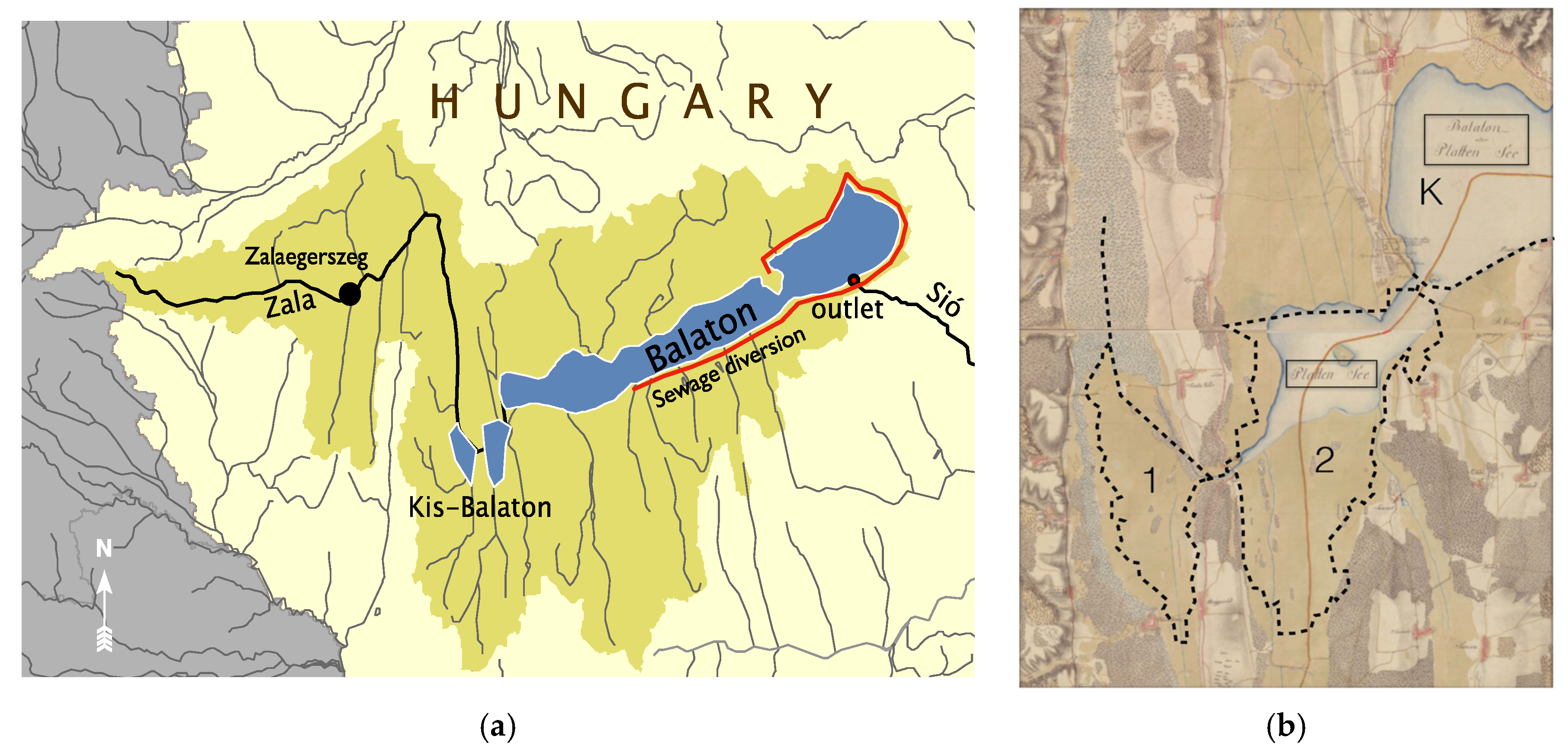
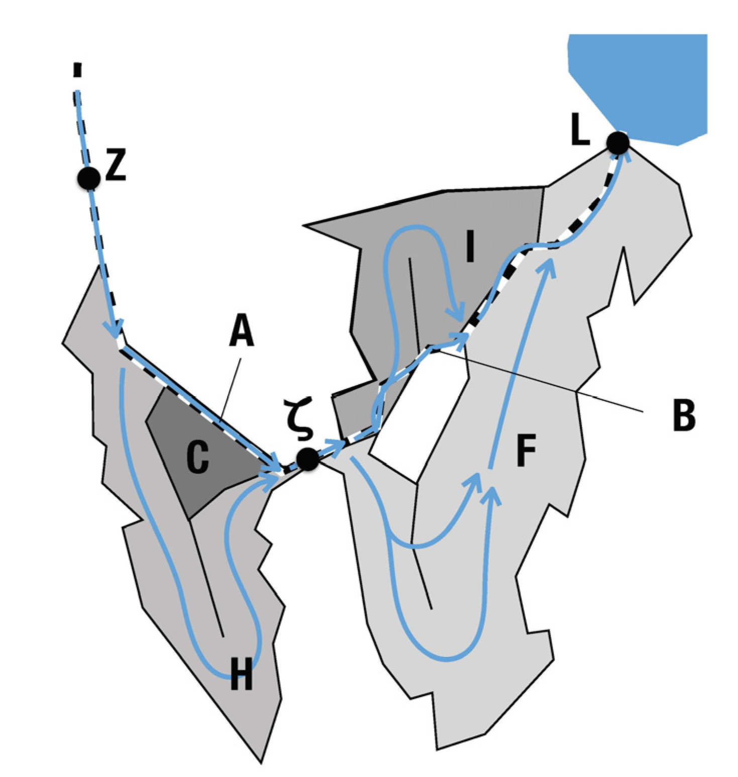
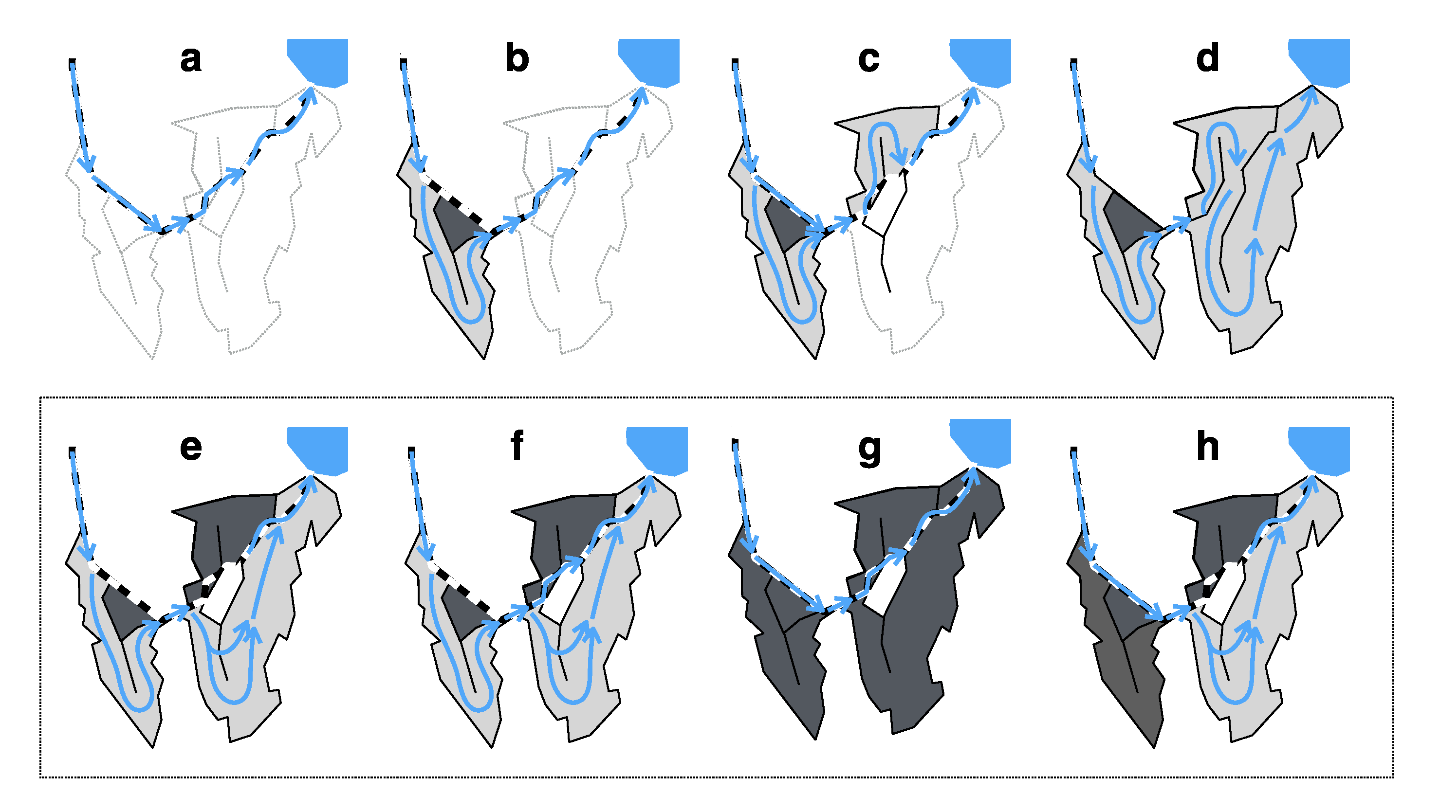
1.1. The Doom and Adventurous Rebirth of the Kis-Balaton Wetlands

Balaton is a large (surface area is 596 km2), shallow (mean depth is 3.2 m) lake, and the second tourist and recreational attraction in Hungary. Given its vital ecological and socioeconomic importance, it has been the most prominent subject of water resources and water quality management since decades [5]. Lake Balaton is a semiastatic lake, which has had climate-driven water level fluctuations of up to 4 m during the past three centuries [6]. This, together with the elongated shape and the asymmetrical catchment (Figure 1a) supported a cascade of adjacent aquatic habitats ranging from wet meadows to periodically inundated swamps and to shallow but permanent open waters (Figure 1b). The regulation of Lake Balaton from the early 1800s resulted in a 3 m drop of the mean water level [7]. Wet habitats dried up on higher altitudes. The shallowest westernmost basin fed by the largest inflow of the lake, the Zala River, was disconnected from the present Lake Balaton. In a century, it developed into a reed dominated swamp. This area and its surrounding wetlands are called the Kis-Balaton wetlands. Regulation of the lower Zala River and extensive drainage works from the early 1900s further deteriorated the state of the wetlands. Reflecting a partial shift in the political attitude, 3 ha of open water and 1400 ha of reed become protected in 1951. A few years later, the fruitless efforts to gain good quality agricultural land by drainage of wetlands had been abandoned, and a new function was assigned to the Kis-Balaton wetlands. The new function was the retention of suspended solids to ease increasing siltation in Lake Balaton, which was a consequence of increasing soil erosion in the catchment.
While designing the “anti-siltation” Kis-Balaton project, Lake Balaton has experienced a well-documented and serious eutrophication from the late 1960s due to the boom of tourism, the lagging development of sewerage construction and wastewater treatment behind public water supply, and the intensive agricultural production in the catchment. By the mid 1970s, the western area of the lake was hypertrophic with regular summer blooms of N2-fixing cyanobacteria and occasional fish kills [8]. The government did its best to keep eutrophication in secret because West German tourists meeting their East German relatives at Lake Balaton were a vitally important source of hard currency income of Hungary. A high-level comrade demonstrated good water quality by publicly drinking a glass of water directly drawn from the lake and containing over 100 mg m−3 of chlorophyll a (Chl) and over 90% filamentous cyanobacteria! Finally, the unprecedented bloom of Cylindrospermopsis raciborskii in 1982 forced the government to take eutrophication seriously [9]. The action plan for management dates back to the decision of the Council of Ministers taken in 1983. In spite of the socialism-specific birth of the decision, its scientific background was particularly solid thanks to the project coordinated by the International Institute for Applied Systems Analysis, in which Lake Balaton was the case study for modelling and managing shallow lake eutrophication. To reduce point loads, 40 farms producing liquid manure were immediately closed up along the Zala River, treated sewage was diverted from the lake in about two thirds of the shoreline settlements by 1986 (Figure 1a), and the largest municipal wastewater treatment plants (WWTPs) of the catchment were to be upgraded with phosphorus removal [10]. As agriculture was a prominent, untouchable sector of the socialist economy, the management of diffuse pollution could not rely on reduction of fertilizer application. Instead, an end-of-pipe solution was conceived [11]. The Kis-Balaton wetlands project was redesigned to retain both nutrients and suspended solids.
The overall area of the Kis-Balaton protection system was planned to reach 147 km2. The motivation for designing such a large area was twofold: (i) to increase hydraulic residence time thereby maximizing the efficiency of retention processes and (ii) to prevent rapid loss of the volume due to siltation. The magnitude of works made it necessary to split the project into consecutive phases.
The ancient, naturally dried-up wetlands situated furthest upstream from Lake Balaton were inundated in phase 1 in 1985 (Lake Hídvégi, H; Figure 2). Influential ecology experts suggested that a macrophyte-dominated lake would retain nutrients and suspended solids with the highest efficiency [12]. To the surprise of these experts and managers, Lake H (surface area 18 km2, mean depth ~1 m, mean water residence time 30 days) has quickly developed into a hypertrophic pond. From 1988, annual mean concentration of Chl fluctuated around 150 mg m−3 at the outflow. The “surprise” could easily be explained. First, Lake H received nearly two times higher area-specific nutrient load than the westernmost basin of Lake Balaton, in which this lower load maintained hypertrophic conditions. The scientifically sound management plan correctly determined the sequence of various measures and emphasized the importance of inundating the Kis-Balaton wetlands only after upgrading the WWTP in the largest town of the catchment (Zalaegerszeg, ca. 60 thousand inhabitants). However, insufficient regulation and the intricacies of institutional and political interests overrode rationality. Second, ecology experts failed to provide sufficient design criteria to facilitate the spread of aquatic macrophytes. Lake H is situated in a wind channel open to the prevailing NW winds and its main axis is nearly parallel with the channel. Therefore, establishment of aquatic macrophytes has efficiently been prevented by the long fetch and frequent breaking waves.
In harmony with global trends, the National Agency for the Protection of Nature and Environment declared the entire territory of the Kis-Balaton project protected in 1986. Protection did not extend to the adjacent wetlands to the North and South of the project area, despite their ecological values that slowly deteriorated in the lack of a sufficient water supply.
In 1991, the WWTP in Zalaegerszeg was finally upgraded and the external phosphate load of Lake H suddenly dropped to about half of its former value. As a result of the enhanced internal P load, the efficiency of P retention decreased dramatically, and hypertrophic conditions persisted.
Following the inundation of Lake H, implementation of the Kis-Balaton project slowed down due to the economic crisis that later led to the political conversion of the country. After the political system collapsed in 1989–1990, the new legislation urged the completion of phase 2. According to the original plan, an area of 51 km2 should have been inundated. Due to the lack of funds, only the 16 km2 northern part, the Ingói Reeds, were inundated in 1993 (Figure 2 and Figure 3). The result was catastrophic. Masses of algae leaving the hypertrophic Lake H died in a few days during their passage through the closed reeds of the Ingói, where no sufficient light was available for aquatic photosynthesis. Phosphate that liberated during fast and temperature-dependent mineralization of algal detritus flowed out from the system in the absence of sediments that might have adsorbed the nutrient [13]. Total P retention was slightly positive on an annual basis due to rapid sedimentation of suspended solids and inorganic particulate P. Decomposition of the detritus, together with the lack of aquatic photosynthesis turned the water anoxic. End products of anaerobic metabolism and increased water depth caused a large-scale die-back of reed in the upstream areas of the Ingói Reeds [14]. To address these problems, the original design of the Kis-Balaton was revised in 1996. The revision concluded that the Ingói Reeds have to be disconnected from the main flow path and dedicated to nature protection. Simultaneously, the not yet inundated lower area (Lake Fenéki, F; Figure 2) should be implemented so that the algal-rich outflow of Lake H should not reach Lake Balaton. No significant P retention was anticipated in the freshly inundated Lake F before a steady state develops in this area. The steady state was perceived as a heterogeneous wetland habitat and mosaics of shallow open water, where long-term P retention is due to P adsorption by the carbonate-rich lacustrine sediments [15,16]. The final revision of the Kis-Balaton Water Protection System took place between 2005 and 2013. It kept the main findings of the previous revision regarding the Ingói Reeds, but suggested to maintain a lower and fluctuating water level in the future Lake F to increase habitat diversity and preserve macrophyte coverage [17]. This shift in the suggested design and operation of Lake F returned to the original concept of the Kis-Balaton system, according to which macrophytes would retain nutrients with higher efficiency than an open-water-dominated lake [17].
The redesigned Lake F was completed in late 2014 thanks to EU funding, yet water had occasionally been diverted to it already from January 2013. The project had the same triad of aims as the original initiative: (i) protecting the water quality of Lake Balaton by retaining nutrients, (ii) protecting and enhancing the ecological value of the Kis-Balaton area, and (iii) reducing flood risks. However, the emphasis moved from objective (i) to objective (ii) and the project was actually listed as a Nature Protection investment. In accordance with the suggested revisions, the Ingói Reeds were isolated from the main flow to protect the ecosystem and to prevent phosphate emission. The Balaton-Felvidéki National Park has been appointed as the manager of the Ingói Reeds.
To prepare for the variability of water quality and nutrient retention, the completed Kis-Balaton system provides several options of operation (Figure 3). Lake F became the U-shaped main flow path, yet its depth was not sufficient to create a fully aquatic habitat, it became a swamp. Both Lakes H and F can be bypassed if, for example, there is a net nutrient emission from the system.

1.2. Management Context and Study Objectives

In summary, the Kis-Balaton Protection System has evolved during a rather long and complex process including several shifts in priorities and objectives. Thus, despite the now “complete” system, it is unclear if the present state and operation of the wetlands provide an optimal solution to the water quality problems of Lake Balaton and nature protection. At the moment, management of the wetlands lacks answers to substantial questions: Has nutrient retention increased along the various setups of the wetlands? Could the present system be controlled better with regard to the objectives? Is another rebuild necessary?
The objective of this study is to provide answers to some of these questions by evaluating the nutrient retention of the wetlands during the various stages of its development (Table 1) and schemes of management. Retention will be assessed retrospectively using a model-based standardized approach including a catchment and a basic water quality model. The ultimate aim is to clarify the contribution of monitoring and modeling to the management of a highly complex system in a changing sociopolitical environment.

2. Materials and Methods

The assessment consisted of the following steps:
  • Compilation of water, suspended solids (SS), and total phosphorus (TP) balances for the entire system and phases 1 and 2 separately. This included estimating non-monitored components (hydraulic, sediment, and nutrient loads from smaller tributaries) by catchment modelling.
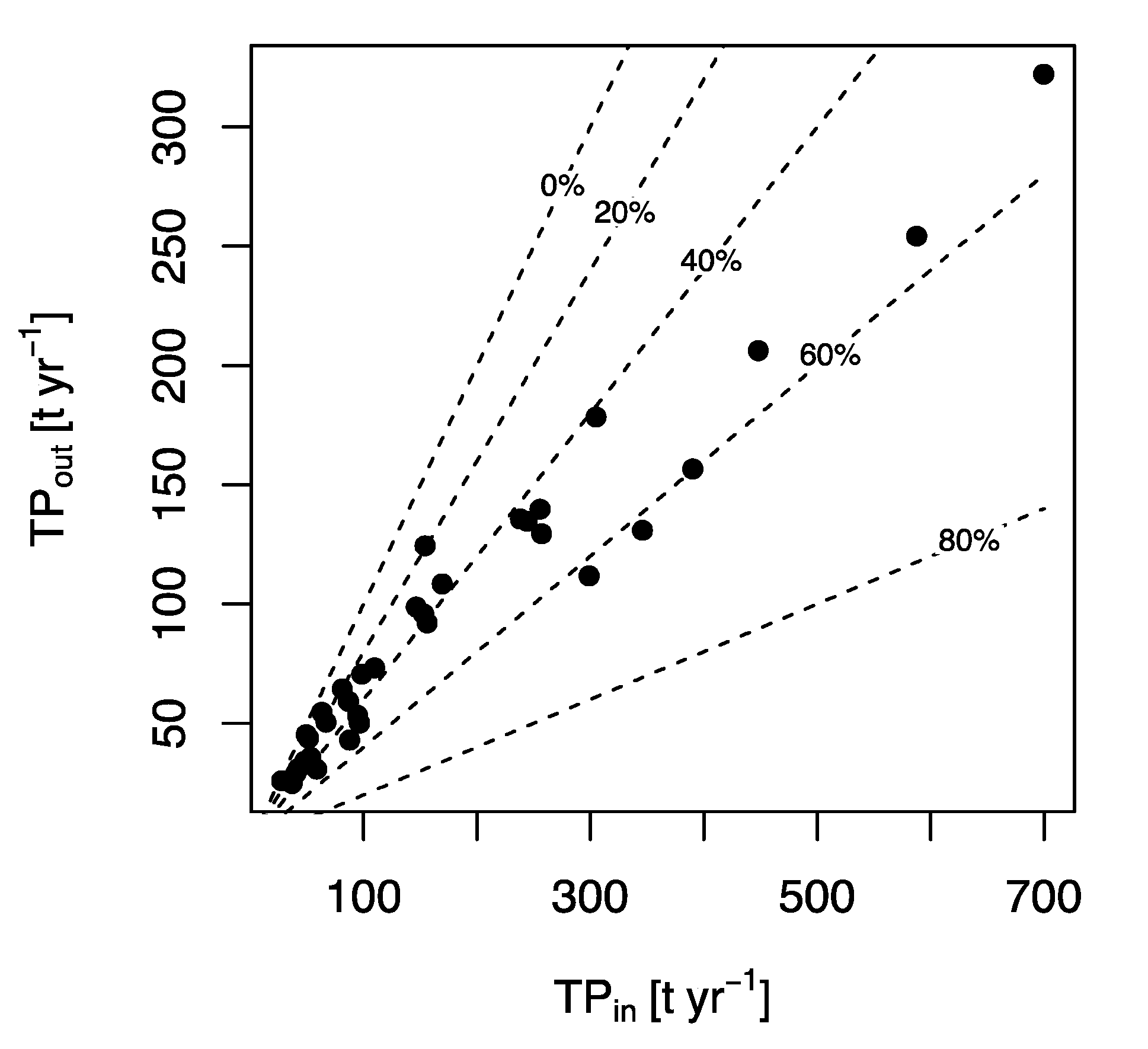
  • Calculation of retentions efficiencies of SS and TP for the entire system and for phases 1 and 2 separately. Retention in Lake H was also simulated by a dynamic model to characterize conditions when a net release of TP was likely.
  • Analysis of retention and the efficiency of management with respect to the declared objectives of the Kis-Balaton system.

2.1. Balances of Water, SS, and TP

The Kis-Balaton system is one of the best-monitored wetland systems in the world. Extensive monitoring and research have started before the inundation of Lake H. Daily discharge data were available in the Zala River and the six largest secondary tributaries of the Kis-Balaton from the 1950s. Of these six tributaries, three enter Lake H, the largest one enters the Ingói Reeds, and the remaining two discharge into Lake F. At the key sections of the Zala River, Z and L, daily water quality measurements have been done from 1977 and 1975, respectively. At ζ, daily load measurements started immediately upon inundation of Lake H in 1985. Similarly, daily water chemistry was measured at the outflow of the Ingói Reeds from 1993 (inundation) to 2013 (exclusion of the Ingói Reeds from the main flow path). Appropriate flow data were missing from the outflow since it was a temporary spillway. Biweekly water quality data has been collected in the largest secondary inflow and two to six samples were taken yearly in 10 small tributaries from 1989. The present water quality monitoring scheme was introduced in 2013. At Z, the frequency of sampling was decreased from seven to three per week. Simultaneously, the frequency was increased in the secondary inflows. The largest secondary inflow is sampled weekly; the largest inflow of Lake H and the two largest inflows of Lake F are sampled biweekly, whereas monthly samples are taken from eight and three small inflows of Lake H and Lake F, respectively. Additional water samples are taken after large rains.
In spite of the large-scale monitoring efforts, material balances are not closed either for the whole system or for its phases 1 and 2. Evaporation, groundwater exchange, and inflows from numerous smaller tributaries as well as from the direct shoreline catchment are not monitored. Discharge from some tributaries (other than Z and ζ) are monitored too sparsely compared to their dynamics. Concentration measurements on small tributaries are less frequent than discharge measurements, thereby rendering direct inputs of TP and SS uncertain. Additionally, changes in the frequency of water quality monitoring during the operation period introduce heterogeneity into the time series.
To bridge these gaps, we compiled a database of hydraulic, sediment, and nutrient loads to the system using the same calculation and quality control methods for the entire existence of the system. First, we estimated the contributions from non-monitored sources by modeling. We used the PhosFate catchment model [18,19] for this purpose. PhosFate is a static, GIS-based model system calculating seasonal mean flows and P loads. Inputs are maps of elevation, land use, physical soil type, meteorology, and nutrient budgets of agricultural soils. The model does not require calibration, except for the region-specific overland and in-stream retention coefficients. As PhosFate had already been calibrated for the Zala catchment upstream of the Kis-Balaton [18], it did not require further adjustments. Contributions of the direct catchments were estimated for both a wet and a dry year (2001 and 2012, respectively) for flow, and as a long-term average for SS and TP.
The estimated relative contribution of the direct catchments and meteorological fluxes were added to the measured inputs at Z and ζ to complete the water balance. Before comparing the in- and outflowing fluxes of SS and TP, an additional correction step was necessary. Despite the good accuracy (error < 5%) of discharge measurements at Z, ζ, and L, the net changes of the completed water balance of Lake H considerably exceeded possible fluctuations in storage. Thus, flow was corrected based on setting the long-term cumulated water balance (e.g., the change in storage) to zero. This approach assumed that the change in storage on a multi-annual basis was negligible relative to the magnitude of water balance errors. Water balance of Lake F was corrected similarly.

2.2. Annual and Seasonal Retention of TP and SS

Since sediment and nutrient retention are the raisons d’être of the Kis-Balaton system, management measures taken during the 35 years of operation were evaluated on the basis of their impacts on the retention. Interventions that had no or detrimental impacts on retention of either TP or SS were considered as unsuccessful.
Annual retention efficiency (R [–]) of TP and SS was calculated from the corrected water and material balances for the whole system and its two phases:
R = F i n F o u t F i n
where Fin and Fout are the in- and outflowing fluxes at the boundaries of the system, respectively.
To explore boundary conditions that are likely to result in negative retentions, that is, net release from the system, we assessed seasonal dynamics of retention using a simple, dynamic mass balance model. The model was applied to Lake H using the corrected daily boundary fluxes as inputs. The model described the change in the amount of total phosphorus in the water:
d M TP d t = L TP M TP Q ζ V H M TP v s V H A H + k r M SP
where MTP is the amount of total phosphorus in Lake H [kg], LTP is the daily TP load at Z [kg d−1], VH is the volume of Lake H [m3], AH is the surface area of Lake H [m2], Qζ is the discharge at ζ [m3 d−1], MSP is the active P content in the surface layer of the sediments [kg], vs. is the apparent settling velocity of TP [m d−1], and kr is the resuspension rate of the surface sediments [d−1]. The dynamics of the P stock in the sediments is:
d M SP d t = M TP v s V H A H k r M SP k b M SP
where kb is the burial rate of the active P content in the sediments [d−1].
If the model with a single set of the three free parameters (vs, kr, and kb) reasonably describes the multiyear behavior of Lake H, it could directly be used to evaluate the impact of internal load on retention processes.

3. Results and Discussion

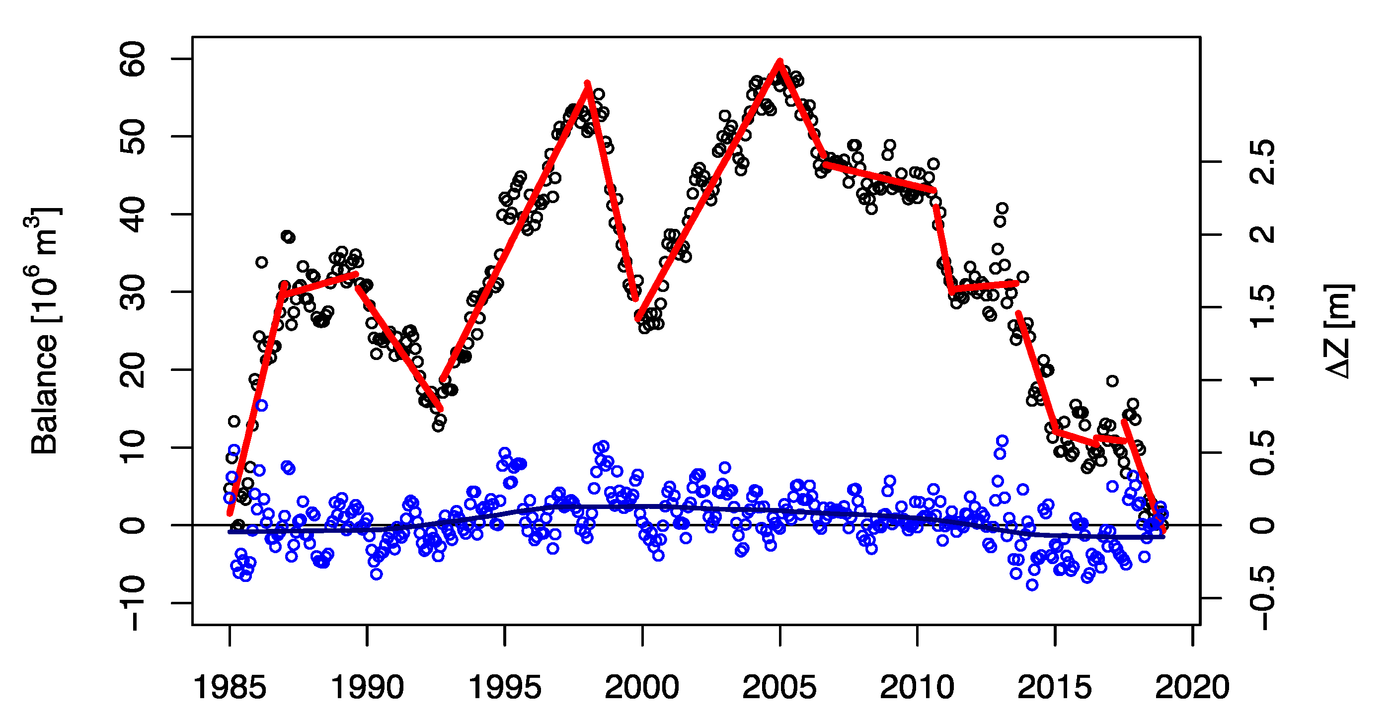
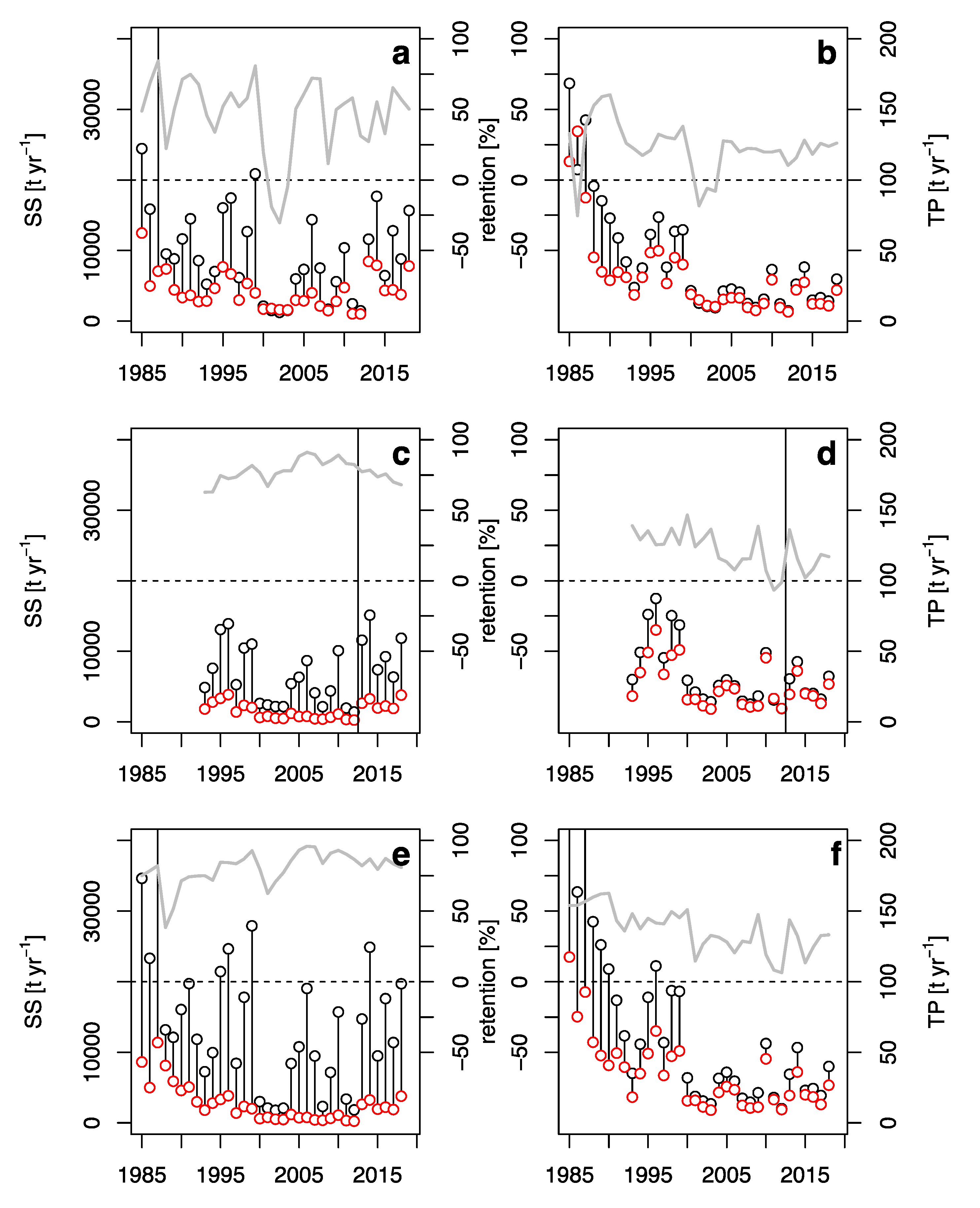
3.1. Balances of Water, SS, and TP

The PhosFate model estimated that direct inflows other than the Zala River contributed 13% of the total flow into Lake H (Table 2). Contrary to Lake H, the secondary tributaries of Lake F have a relatively large catchment area (755 km2, 30% of total) and the proportion of secondary inflow is larger, 29% and 40% in wet and dry years, respectively. These results highlight that the larger Zala catchment is water deficient compared to the smaller secondary tributaries. Due to sporadic measurements on many secondary tributaries, these estimates cannot systematically be compared with data. Yet, the mean ratio of flows from simultaneous observations in secondary tributaries and in the Zala River broadly supports model results; measured secondary contributions to Lake H made up 9.2% of the outflow in the period covered with data, modelled contribution was 7.1%. For Lake F, the respective values were 31.9% and 29.1%.
Model results showed that in Lake H secondary tributaries contributed 12% and 14% of SS and TP loads, respectively. The respective values were 13% and 20% in Lake F. While in Lake H the contribution of small tributaries was roughly similar in terms of both discharge and loads, in Lake F secondary loads of SS and TP were disproportionately low relative to flow (Table 2).
The long-term cumulated water budget of Lake H showed several longer and shorter periods of systematically increasing or decreasing trends, even after correcting for the inputs of secondary tributaries and meteorological water fluxes (Figure 4). We calculated how much mean water depth would have changed if these trends have been related to a change in storage. Evidently, the systematic error in the cumulated water budget greatly exceeded the storage capacity of Lake H (Figure 4). Accordingly, periodically constant correction terms had to be applied to the water balance to keep the closing error in the range, which could realistically be accounted for by the dynamics of storage volume (Figure 4). Although ζ is situated downstream of the large storage volume of Lake H, daily flows occasionally showed rapid oscillations when the flow at Z changed smoothly. This indicated that flow measurements might be less reliable at ζ than at Z and therefore, only the ζ-discharge was corrected. Noticeably, the necessary mean correction was only 3.2% of the mean flow of Z, a value definitely within the accuracy of best-conducted discharge measurements.
The water budget of phase 2, that is the joint hydrological balance of Lake F and the Ingói Reeds was corrected using the same approach, but with considering the corrected flow at ζ. The long-term mean correction was nearly 0, but, in certain periods, a correction as high as 1 m3 s−1 (21% of mean flow) was necessary. This could be due to the complicated hydrology of this patchy area and the relatively large contribution of weakly monitored tributaries to the total inflow (Table 2). As there was no single suspect to assign the corrections, they were halved between the outflow (L) and the direct tributaries.

3.2. Retention and Evaluation of the Operational Success

The SS load of Lake H showed large fluctuations ever since the inundation (Figure 5). Outflowing fluxes of SS were always lower than the inflowing ones; efficiency of annual retention varied between 50% and 75%. This indicated that Lake H, and especially its northern area near the inflow, functioned as a settling tank [20]. In contrast to the fluctuating SS load, TP load decreased systematically in the period 1987 to 1993 from about 100 t yr−1 to below 50 t yr−1 (Figure 5). Upgrading of the WWTP in Zalaegerszeg (nominal capacity is 15,000 m3 d−1) in 1991 (Table 1) significantly contributed to this trend. In about two to three years after inundation, a steady state had established with respect to TP retention, which stabilized at around 50%. Similar to other lakes, the external loads of which were reduced significantly [21], retention efficiency of Lake H decreased to 30% on average upon the drop of its external TP load during the 1990s. Negative retention efficiencies (net release) were observed during the drought in 2000–2003, when the TP flux at Z decreased below 10 t yr−1 due to the diminutive surface runoff and diffuse TP emission. Decreases of TP retention could be related to enhanced internal P load, which is a result of the imbalance between the P content of the freshly forming sediments and that of the surface sediments accumulated during the period of high external load [22]. Obviously, the absolute fluxes during the periods of low and negative retention were much smaller than in wet years when TP retention was stable and high.
Similar to Lake H, the annual SS load of phase 2 of the Kis-Balaton also fluctuated widely. Until 2013, the Ingói Reeds intercepted this load with efficiencies over 80%. This high retention was due to the lack of resuspension in the dense reed stands, which fully sheltered the water from the wind [23]—similarly to other systems [24]. A slight reduction could be observed in SS retention, when the flow was turned from the Ingói Reeds to Lake F. Since the latter is also covered by dense macrophyte vegetation, it is not clear, whether this slight deterioration is a transient phenomenon. TP retention zigzagged between 0 and 30% both before and after 2013 and did not show any correlation with meteorological boundary conditions. Thus, phase 2 of the Kis-Balaton played a decisive role in the retention of SS, governed solely by physical processes, and a minor role in TP retention that depends on intricate interactions of physical, chemical, and biotic processes.
The behavior of the entire system was more stable than that of its components. SS retention was stabilized between 75% and 90% by the reliable performance of phase 2. Overall annual retention efficiency of TP has been usually low from 2000, but always in the positive domain (10–60%).
The simple dynamic mass balance model reasonably reproduced the observed daily TP flux at the outflow of Lake H (Figure 6). Optimal parameter values were vs = 0.002 m d−1, kr = 7.3·10−5 d−1, and kb = 1.2·10−8 d−1. These suggest that assuming a mean depth of 1 m, the half-life of TP would be 346 days in the water column. Moreover, the sediment stock practically never gets exhausted, and it can re-enter the water whenever conditions favor internal P load. These imply that the load reduction during the recent decade might increase the relative weight of internal load in the outflowing P flux. According to the model, negative retention (net release) of TP is likely to occur in months when the incoming P load is less than 2 t month−1.

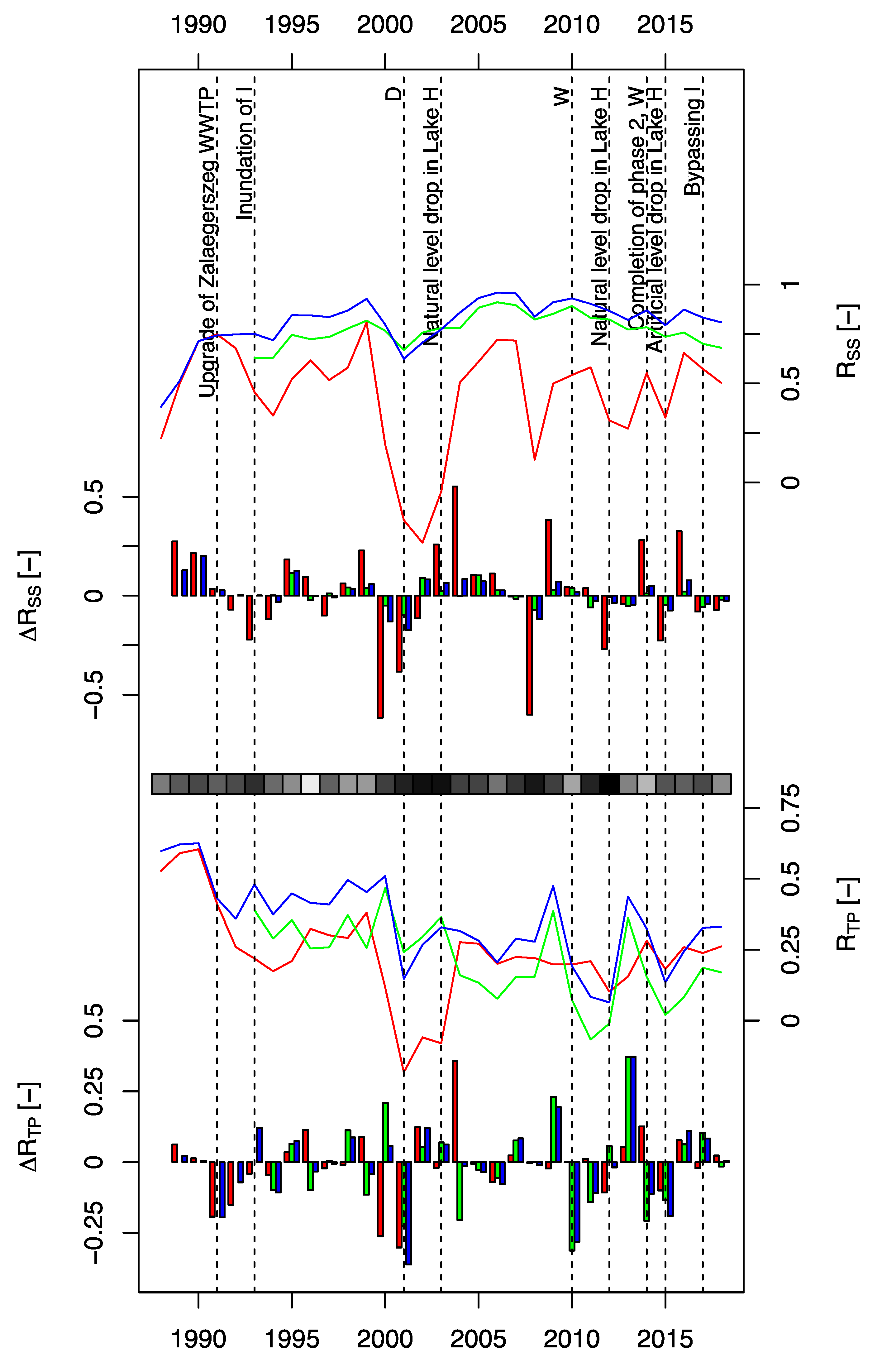
3.3. Futile Management Actions

Several interventions aimed at optimizing the operational objectives of retention and nature protection. One such intervention was the gradual drawdown of Lake H. The water level of this lake dropped by 30–50 cm corresponding to about a 30–50% decrease in storage volume during the summers of 2003, 2012, 2013, and 2014 because inflow could not compensate evaporation and outflow. From 2015, the newly introduced operational guidelines directed a planned reduction of the summer water level by 50 cm in 10 cm yr−1 increments. The reasoning was that Lake H typically does not retain nutrients in the dry and hot summer months, so ecological objectives could be pursued without compromising water quality targets. It was envisioned that a lower water level would favor the spread of macrophytes and increase habitat diversity. Noticeably, neither local experience nor monitoring data gave any support to this vision. Macrophytes failed to invade a larger area in Lake H during previous years when the water level was low. Moreover, monitoring data indicated that monthly mean TP concentrations at the outflow tended to increase with decreasing monthly mean water levels. The increase was roughly threefold (from 20 to 60 mg P m−3) in the range of 20 cm to 50 cm drop in water level, greatly decreasing the efficiency of P retention. The unsuccessful and unreasonable intervention was terminated after two years.
Another futile intervention was the construction of the bypass of Lake H. The present design of the Kis-Balaton provides a high operational flexibility (see Figure 3 panels e–h). Low or negative TP retention during months of low flow conceived the idea of activating bypass mode in Lake H when the TP flux at the outflow (ζ) exceeded that at the inflow (Z) by more than 30% for more than a week [22]. During the summer of 2015, bypass operation was tested in Lake H for six weeks. During this period, the mean concentration of nitrate-N and chlorophyll a was 2 g m−3 and 6 mg m−3, respectively in the Zala River at Z. At the inflow section of the bypass channel A, the respective values were 0.16 g m−3 and 112 mg m−3. Thus, water quality measurements indicated that the bypass weir failed to lead the water of the Zala River into channel A; it rather drained waters from the northern area of Lake H. This might happen because Lake H was inundated by cutting a sequence of openings into the right-hand bank of the Zala River, whereas the bypass weir is situated a few kilometers downstream from the openings. The insufficient design has most likely been chosen to make the investment cheaper, yet the result was costly: the bypass of Lake H does not work and needs to be redesigned.
Yet another ineffective intervention was the bypass of Lake F. As mentioned above, revision of phase 2 was motivated by the catastrophic effects of inundating the Ingói Reeds with the algal-rich outflow of Lake H that included summer release of phosphate and die-back of the reed. After the redesign of phase 2, ecological objectives have become dominant in the operation of the entire Kis-Balaton. The objective of managing the Ingói Reeds were (i) to satisfy the ecological water demand, and (ii) to mimic the “natural” fluctuations of water level. Criteria for ecological water requirements have not been defined to govern flow routing. This has led to a paradoxical practice. In line with the two objectives, 13% to 21% of the annual flow at ζ was diverted to the Ingói with the exception of 2015, when the diversion was negligible (<2%). However, for unknown reasons the bypass weir was kept open in 2017 to 2019. As a consequence, the supplied water did not spread out in the Ingói Reeds but flowed through the old Zala River channel to bypass channel B. In contrast to management objective (ii), variance of daily water level decreased by a factor of 3.6 in the period 2014–2018 compared to 2005–2013. As a side-effect of the apparent water supply to the Ingói Reeds, elevated SS concentrations were observed at L, the vivid fluctuations of which were synchronous with the fluctuations at ζ (Figure 7). Although Lake F is a densely vegetated wetland system, the overall retention of SS decreased after its inundation because of the direct passage of a significant volume of water along bypass B.
Finally, the design of Lake F does not seem to ensure spreading out the water in this large area. Lake F is twice as large as the Ingói Reeds and the planned mean water residence time was correspondingly higher. Therefore, according to the plans, the opening of Lake F should have increased the retention of TP, since (a) TP retention in the Ingói Reeds was low (Figure 5) due to the conversion of algal-bound P to phosphate and (b), the relatively large direct tributaries of Lake F formerly passed the wetlands and joined the Zala River without stretching out. In contrast to the plans, TP retention of the entire system did not increase in comparison to the period before opening Lake F (Figure 5). One of the reasons was the new operational scheme of the Ingói Reeds. Another reason was the sub-optimal hydraulic profile of Lake F. The trapezoidal channels of the direct tributaries of Lake F were kept nearly intact for flood protection purposes. These longitudinal openings have much smaller hydraulic resistance than the densely vegetated shallows of the wetland, and therefore most of the water (80–90%) flowed along the channels towards L. For the time being, the real water residence time in Lake F is unknown but certainly much less than the theoretical residence time estimated from lake and inflow volumes.

3.4. Climate as the Chief Manager

The timelines of SS and TP retentions and their dynamics indicate that climatic factors were the ultimate drivers of retention processes in the Kis-Balaton system (Figure 8). In dry years, loads and retentions plummeted, in wet years both increased. The primary role of climate-related factors behind these dynamics such as discharge, residence time, erosion, and diffuse P loads suggests that management actions were of secondary importance and could not significantly influence the efficiency of retention. The only exception was the reduction of external TP load between 1987 and 1993 related to years long cessation of fertilizer application due to the collapse of agriculture after the change in the political system in 1989–1990 and to upgrading the WWTP in Zalaegerszeg (Table 1). The initial TP retention of the entire system was 50–60% on average, and it decreased to 30–40% after this load reduction (Figure 9). No interventions could restore the retention to its value before the load reduction. Conclusively, this huge and complex quasi-natural system follows its own way of operation autonomously; management actions targeting the operation of the system resulted in only marginal improvements (if any) in retention.

3.5. Does Science-Based Rational Environmental Management Exist in Practice?

Despite the immense monitoring and scientific efforts that supported management, numerous scientifically justified and apparently rational management actions proved futile. It was only the initial concept of creating a prestorage that proved to be robust in the long-term. The predictive power of science was generally weak, only retrospective analysis could explain:
  • the absence of macrovegetation cover in Lake H after inundation;
  • the negligible TP retention efficiency of dense reedstands when load is mostly algal P;
  • TP retention efficiency of the complex habitat in the hydraulic boundary conditions of Lake F;
  • the efficiency of bypass without a hydraulically well-defined upstream section.
Monitoring was exceptionally intensive, yet insufficient to
  • close the material balances and provide a solid basis for retention assessments;
  • follow the behavior of the complex lake F.
During the design, implementation, and operation of the Kis-Balaton project, the political weights of the interested sectors changed too. Before 1990, the National Water Authority was a highly autonomous powerful state organization with a mixed mandate that covered both management and legal control. After 1990, most of its former power suddenly vanished; ecology and nature protection became more prominent. Between the inundation of the Ingói Reeds (1993) and the final revision of the plans of Lake F (2005–2013), in parallel with the recognition that the (re)constructed wetland system created a huge ecological asset, nature protection perspectives dominated management and planning. The realization of Lake F was even funded with the primary objective of increasing the ecological potential by saving the vegetation of the Ingói Reeds and creating a diverse habitat in Lake F. Nutrient retention and the management of the nutrient load of Lake Balaton (itself a Ramsar site during the winter months) has always been of secondary importance for the National Park. In recent years, due to the boom of infrastructural investments and cuts on the state financing of nature protection, the roles seem to change again soon. The likelihood of this outcome increased substantially in 2019, when an unprecedentedly large late summer bloom of phytoplankton developed in the southwestern areas of Lake Balaton (Honti and Istvánovics, unpublished data, peak concentration of chlorophyll was around 300 mg m−3; Table 1) after 25 years of acceptable water quality, during which time water quality management was considered to successfully arrest eutrophication [25]. Conclusively, the political background was a far more important driver of management actions than science-based data analysis and prediction.

3.6. Final Balance of the Kis-Balaton Project

Since the inundation of Lake H, the Kis-Balaton system retained approximately 140,000 tons of SS and 366 tons of TP. No estimates are available about the total costs of the Kis-Balaton project, but the low retention efficiency resulted in a very high specific cost in the order of 1000 € (kg P)−1. The low direct cost efficiency was counterbalanced by a series of socioeconomic and environmental benefits from development of recreational tourism at Lake Balaton including its southwestern areas to boost of ecotourism in the Kis-Balaton region and to the renewal of a large, undisturbed wetland habitat.

4. Conclusions

The management history of Kis-Balaton illustrates the difficulty of operating a complex system along different and often conflicting objectives. Despite efforts to manage the system on the basis of scientific evidence and forecasts, the coherent, model-based review of material balances showed that most management actions were futile and did not result in a better fulfilment of the principal objectives. Therefore, the question remains open: what kind of institutional setup could ensure that operational experience and simple, target-oriented analysis of existing monitoring data a priori excluded fruitless management efforts?
The high autonomy of the system during its history suggests that a less proactive management could operate the system in a more natural (and less managed) way with roughly the same efficiency but with significantly less efforts and running costs. Nevertheless, considering the lessons learnt in this large and complex wetland system (namely: the importance of implementation sequence, vegetation dynamics, weather-induced retention variability, and steady political boundary conditions) can facilitate the design and operation of other large constructed wetlands dedicated to improve water quality.

Author Contributions

Conceptualization was done by V.I. and M.H.; the methodology was designed by V.I., A.C. and M.H.; all authors contributed to the formal analysis; data curation was done by A.C., V.I. and C.G.; for writing, all authors contributed to both original draft preparation, review and editing; visualization was done by M.H. All authors have read and agreed to the published version of the manuscript.

Funding

This research was funded by National Research, Development and Innovation Office, grant number NNE 129990 and FIKP-VÍZ, and General Water Directorate of Hungary under contract “Analysis of the background load of the Kis-Balaton”.

Acknowledgments

Data and advice from the West Transdanubian Water Directorate is gratefully acknowledged.

Conflicts of Interest

The authors declare no conflict of interest. The funders had no role in the design of the study; in the analyses, or interpretation of data; in the writing of the manuscript, or in the decision to publish the results.

References

  1. McIntosh, B.S.; Ascough, J.C.; Twery, M.; Chew, J.; Elmahdi, A.; Haase, D.; Harou, J.J.; Hepting, D.; Cuddy, S.; Jakeman, A.J.; et al. Environmental decision support systems (EDSS) development—Challenges and best practices. Environ. Model. Softw. 2011, 26, 1389–1402. [Google Scholar] [CrossRef]
  2. Eisenführ, F.; Weber, M.; Langer, T. Rational Decision Making; Springer: Berlin, Germany, 2010; ISBN 978-3642-028-489. [Google Scholar]
  3. von Winterfeldt, D. Bridging the gap between science and decision making. Proc. Natl. Acad. Sci. USA 2013, 110 (Suppl. S3), 14055–14061. [Google Scholar] [CrossRef] [PubMed] [Green Version]
  4. Reichert, P.; Langhans, S.D.; Lienert, J.; Schuwirth, N. The conceptual foundation of environmental decision support. J. Environ. Manag. 2015, 154, 316–332. [Google Scholar] [CrossRef] [PubMed] [Green Version]
  5. Somlyódy, L.; van Straten, G. Modeling and Managing Shallow Lake Eutrophication: With Application to Lake Balaton, 1st ed.; Springer: Berlin, Germany, 1986; ISBN 978-3-642-82709-9. [Google Scholar] [CrossRef] [Green Version]
  6. Zlinszky, A.; Timár, G. Historic maps as a data source for socio-hydrology: A case study of the Lake Balaton wetland system, Hungary. Hydrol. Earth Syst. Sci. 2013, 17, 4589–4606. [Google Scholar] [CrossRef] [Green Version]
  7. Virág, Á. Past and Present of Lake Balaton [A Balaton Múltja És Jelene]; Egri Press Ltd.: Eger, Hungary, 1998; (In Hungarian). ISBN 9639060216. Available online: https://library.hungaricana.hu/en/view/VizugyiKonyvek_244a/ (accessed on 28 February 2020).
  8. Herodek, S. Phytoplankton Changes during Eutrophication and P and N Metabolism. In Modeling and Managing Shallow Lake Eutrophication: With application to Lake Balaton; Somlyódy, L., van Straten, G., Eds.; Springer: Berlin, Germany, 1986; ISBN 978-3-642-82709-9. [Google Scholar] [CrossRef] [Green Version]
  9. Láng, I. Impact on Policymaking: Background to a Government Dcision. In Modeling and Managing Shallow Lake Eutrophication: With Application to Lake Balaton; Somlyódy, L., van Straten, G., Eds.; Springer: Berlin, Germany, 1986; ISBN 978-3-642-82709-9. [Google Scholar] [CrossRef] [Green Version]
  10. Istvánovics, V.; Somlyódy, L. Factors influencing lake recovery from eutrophication—The case of Basin 1 of Lake Balaton. Water Res. 2001, 35, 729–735. [Google Scholar] [CrossRef]
  11. Somlyódy, L. Eutrophication Management Models. In Modeling and Managing Shallow Lake Eutrophication: With Application to Lake Balaton; Somlyódy, L., van Straten, G., Eds.; Springer: Berlin, Germany, 1986; ISBN 978-3-642-82709-9. [Google Scholar] [CrossRef] [Green Version]
  12. Kárpáti, I. Biological Foundations for the Operational. Technological and Organisational Concepts of Kis-Balaton Protection System [“A Kisbalaton Védőrendszer Üzemeltetésének. Technológiai És Üzemszervezési Koncepcióinak Biológiai Megalapozása”]; Agricultural University of Keszthely: Keszthely, Hungary, 1980. (In Hungarian) [Google Scholar]
  13. Istvánovics, V.; Kovács, A.; Vörös, L.; Herodek, S.; Pomogyi, P. Phosphorus cycling in a large, reconstructed wetland, the lower Kis-Balaton Reservoir (Hungary). SIL Proc. 1922–2010 1997, 26, 323–329. [Google Scholar] [CrossRef]
  14. Čıžková, H.; Pechar, L.; Husák, Š.; Květ, J.; Bauer, V.; Radová, J.; Edwards, K. Chemical characteristics of soils and pore waters of three wetland sites dominated by Phragmites australis: Relation to vegetation composition and reed performance. Aquat. Bot. 2001, 69, 235–249. [Google Scholar] [CrossRef]
  15. Somlyódy, L.; Herodek, S. Revision of the Lower Reservoir of Kis-Balaton—Synthesis Report [“A Kis-Balaton Alsó-Tározó Felülvizsgálata. Szintézis Jelentés”]; Budapest University of Technology and Economics, Department of Sanitary and Environmental Engineering: Budapest, Hungary, 1997. (In Hungarian) [Google Scholar]
  16. Somlyódy, L. Eutrophication Modeling, Management and decision making: The Kis-Balaton Case. Water Sci. Technol. 1998, 37, 165–175. [Google Scholar] [CrossRef]
  17. BioAquaPro. Proposal on the Operation Regime of the Kis Balaton Water Protection System. Biomonitoring System for the Implementation of the 2nd Phase of Kis Balaton” Project. [A Kis-Balaton Vízvédelmi Rendszer Üzemeltetéssel Kapcsolatos Előzetes Javaslatok. «Kis-Balaton Vízvédelmi Rendszer II. Ütem Megvalósítása» Projekthez Kapcsolódó Biomonitoring Rendszer Kialakítása”]; KEOP-2.2.1/2F/09-2009-0001 project report; BioAquaPro Ltd.: Debrecen, Hungary, 2018. (In Hungarian) [Google Scholar]
  18. Kovács, Á.; Honti, M.; Clement, A. Design of best management practice applications for diffuse phosphorus pollution using interactive GIS. Water Sci. Technol. 2008, 57, 1727–1733. [Google Scholar] [CrossRef] [PubMed]
  19. Kovács, Á.; Honti, M. Estimation of diffuse phosphorus emissions at small catchment scale by GIS-based pollution potential analysis. Desalination 2008, 226, 72–80. [Google Scholar] [CrossRef]
  20. Clement, A.; Somlyódy, L.; Koncsos, L. Modeling the phosphorus retention of the Kis-Balaton upper reservoir. Water Sci. Technol. 1998, 37, 113–120. [Google Scholar] [CrossRef]
  21. Sas, H. Lake Restoration and Reduction of Nutrient Loading: Expectations Experiences and Extrapolations; Academia Verlag Richarz: St. Augustin, Germany, 1989; ISBN 978-3883453798. [Google Scholar]
  22. Istvánovics, V.; Somlyódy, L. The role of sediments in P retention of the Kis-Balaton reservoir. Int. Rev. Hydrobiol. 1998, 83, 225–234. [Google Scholar]
  23. Gaál, R.; Bencsics, A.; Puskás, Z. Provisional Operational Procedures for the Kis-Balaton Water Protection System [“KBVR Ideiglenes Üzemeltetési Szabályzat”]; West Transdanubian Water Directorate, West Transdanubian Environmental and Nature Protection Authority and Balaton-felvidéki National Park: Szombathely, Hungary, 2014; p. 40. (In Hungarian) [Google Scholar]
  24. Rodrigo, M.A.; Valentín, A.; Claros, J.; Moreno, L.; Segura, M.; Lassalle, M.; Vera, P. Assessing the effect of emergent vegetation in a surface-flow constructed wetland on eutrophication reversion and biodiversity enhancement. Ecol. Eng. 2018, 113, 74–87. [Google Scholar] [CrossRef]
  25. Istvánovics, V.; Clement, A.; Somlyódy, L.; Specziár, A.; G.-Tóth, L.; Padisák, J. Updating water quality targets for shallow Lake Balaton (Hungary), recovering from eutrophication. Hydrobiologia 2007, 581, 305–318. [Google Scholar] [CrossRef]
Figure 1. (a) Position of the Kis-Balaton wetlands within the Lake Balaton catchment. Zala is the largest tributary; Zalaegerszeg is the largest town upstream of Kis-Balaton. The red line indicates the sewage collector belt around Lake Balaton; (b) the western parts of Lake Balaton in the First Military Survey of Hungary (1782–1785, map slides with permission of Österreichischen Staatsarchiv) and the present outlines of the Kis-Balaton system. K: Keszthely Basin, presently the westernmost basin of Lake Balaton; 1 and 2: phases of the present Kis-Balaton system. “Lake Balaton” (in German, “Platten See” is written in the thin frames).
Water 12 00659 g001
Figure 2. The present Kis-Balaton Water Protection System. Z: Zala River; H: Lake Hídvégi inundated in phase 1; C: emergency reservoir to enclose and treat pollution (e.g., oil spill) from Z; A: bypass of H; ζ: connector between phases 1 and 2 (a section of the Zala River); I: Ingói Reeds; F: Lake Fenéki inundated in phase 2, B: bypass of F; L: inflow into Lake Balaton. Black dots indicate major monitoring sites of inputs and outputs, blue arrows indicate alternative, adjustable pathways of flow.
Water 12 00659 g002
Figure 3. Historical (ac), originally planned (d), and present (eh) operational setups of the Kis-Balaton. (a): before 1985; (b): 1985–1992; (c): 1993–2013; (d): original plan of the complete system, (eh): main flow routing options since 2014; (e) shows the normal way of operation. Dark shading indicates stagnant/bypassed water bodies, blue arrows show flow paths. Flow sequences using the codes from Figure 2 are as follows: in (a) ZAζBL, in (b) ZHζBL, in (c) ZHζIL, in (d) ZHζIFL, in (e) ZHζFL, in (f) ZHζ{2/B}L, in (g) ZAζBL, in (h) ZAζFL. The original plan of the Kis-Balaton was ZHζIFL. At present the following flow patterns are also possible: ZHζ{I/F}L, ZAζIL, ZAζ{I/2}L, ZAC, where curly brackets indicate parallel alternative pathways.
Water 12 00659 g003
Figure 4. Cumulated water balance of Lake H based on raw measurements and a simple correction for long-term trend (black circles) and corrected discharges (blue circles). Red straight lines indicate manually delineated periods of constant systematic errors, blue line is a local polynomial regression (LOESS) on the corrected discharge. Right axis shows approximate change in storage level.
Water 12 00659 g004
Figure 5. Fluxes (black circles: incoming, red circles: outgoing, connected for clarity) and retentions (gray line) of suspended solids (SS) and total phosphorus (TP) in Lake H (a,b), in the area of phase 2 (c,d), and in the entire system (e,f). In c and d, the vertical line indicates diversion of flow from the Ingói Reeds to Lake F in January 2013.
Water 12 00659 g005
Figure 6. Observed and modelled TP fluxes at site ζ.
Water 12 00659 g006
Figure 7. Observed SS concentrations at sites ζ and L (1 month moving averages). The Ingói reeds operated between the two dashed lines.
Water 12 00659 g007
Figure 8. Retentions of SS (RSS) and TP (RTP) and their annual changes (ΔRSS and ΔRTP, respectively). Red: Lake H, green: phase 2, blue: entire system. The grayscale ribbon indicates the relative magnitude of flow at Z, dark: minimal, light: maximal. “W” and “D” indicate extremely wet and dry years, respectively.
Water 12 00659 g008
Figure 9. Outflowing flux of TP (TPout) as a function of inflowing TP flux (TPin) for the entire system. Isolines show constant retention rates.
Water 12 00659 g009
Table 1. Timeline of development.
DateEvent/Action
1970sEutrophication of Lake Balaton
1982Unprecedented large bloom of Cylindrospermopsis raciborskii in Lake Balaton
1983Decree of the Council of Ministers
1985Completion of Lake H (phase 1)
1986The whole Kis-Balaton project area gets nature protection status
1990Collapse of agriculture in relation to the change of the political system
1991Upgrade of WWTP in the town of Zalaegerszeg
1993Inundation of the Ingói Reeds (start of phase 2)
1996Revision of plans of phase 2
2013Start of flow diversion from Ingói Reeds to Lake F
2014Official completion of Lake F
2019Unprecedented large bloom of Aphanizomenon flos-aquae and Ceratium furcoides in Lake Balaton
Table 2. Contribution of secondary tributaries.
Type of YearFlowSSTP
Lake HAverage9%12%14%
Dry13%
Wet9%
Lake FAverage33%13%20%
Dry40%
Wet29%

