Estimation of Wastewater Discharges by Means of OpenStreetMap Data
Abstract
1. Introduction
2. Materials and Methods
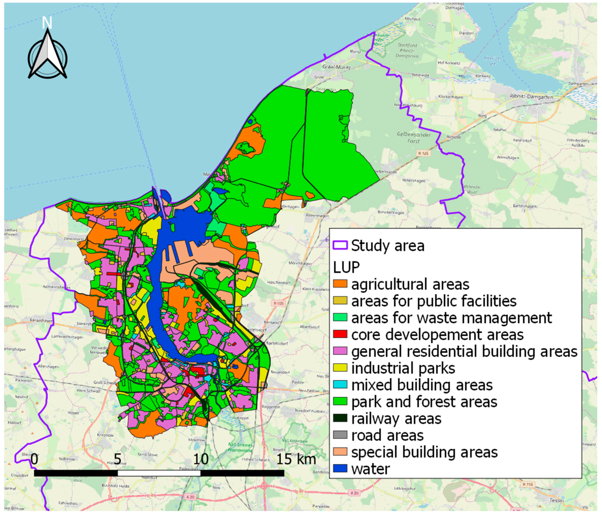
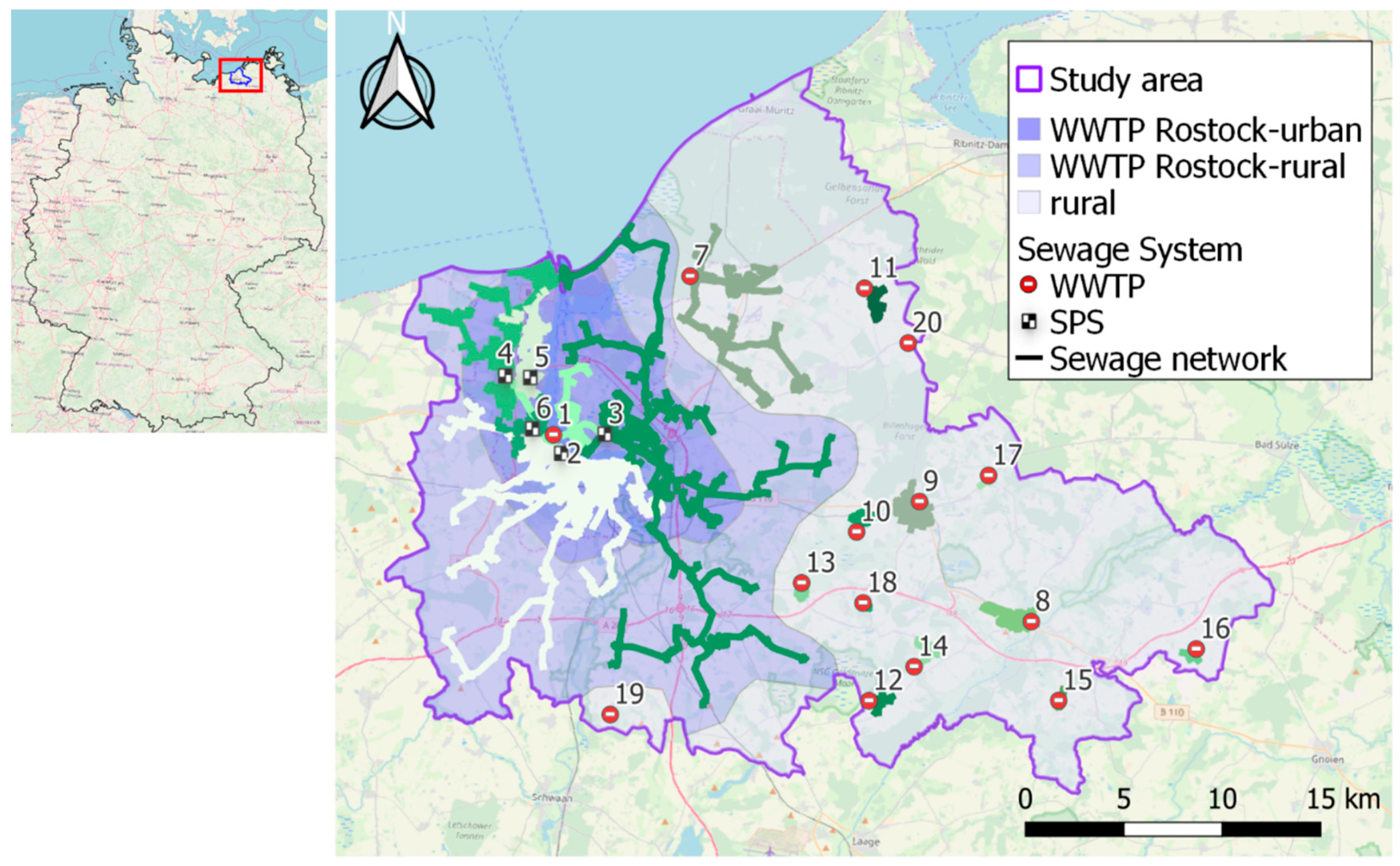
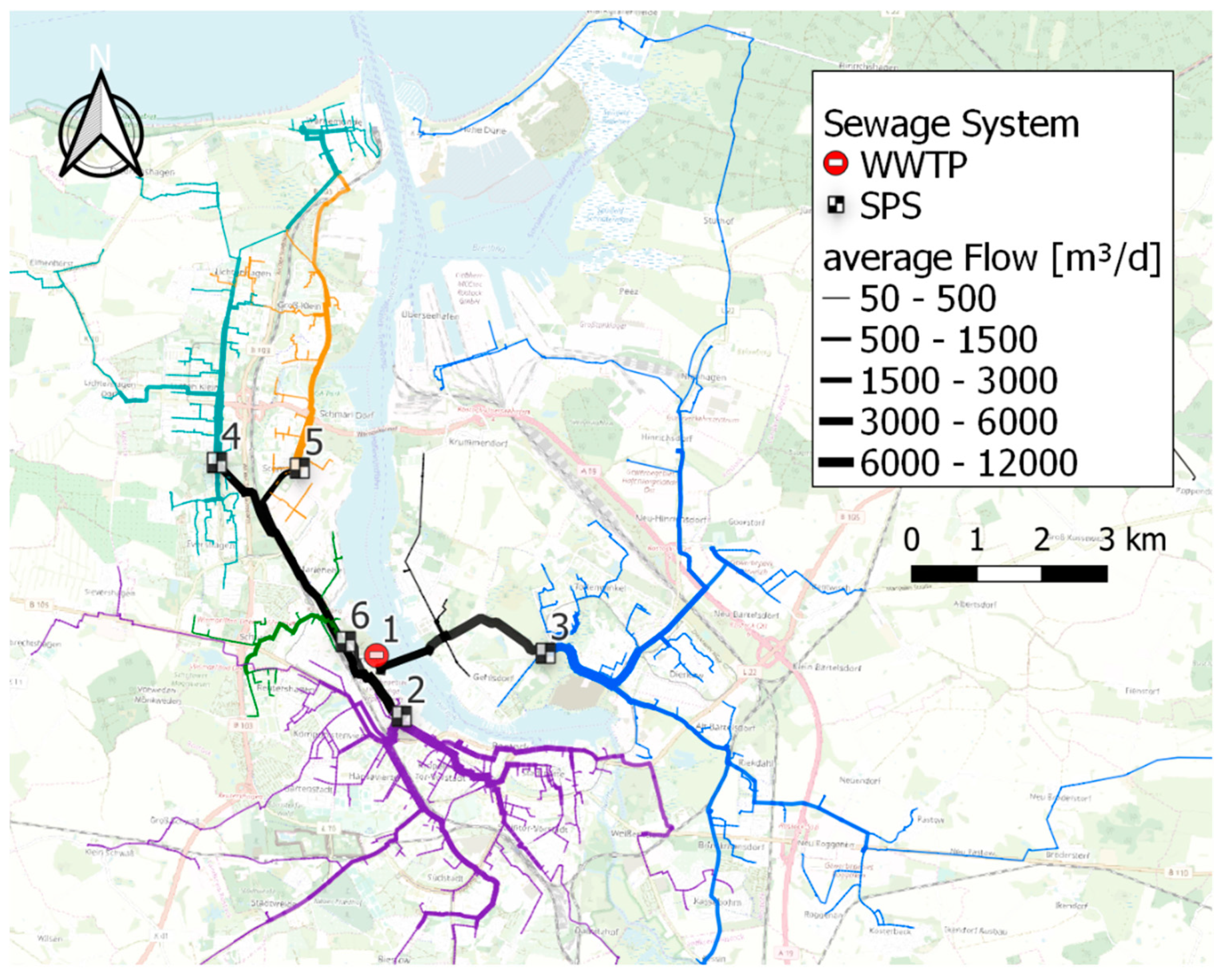
2.1. Study Area
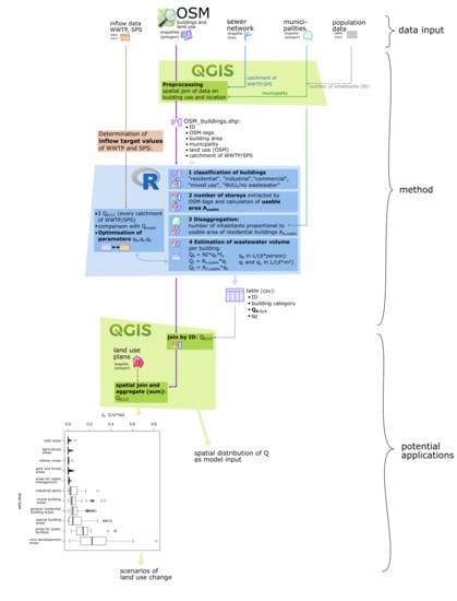
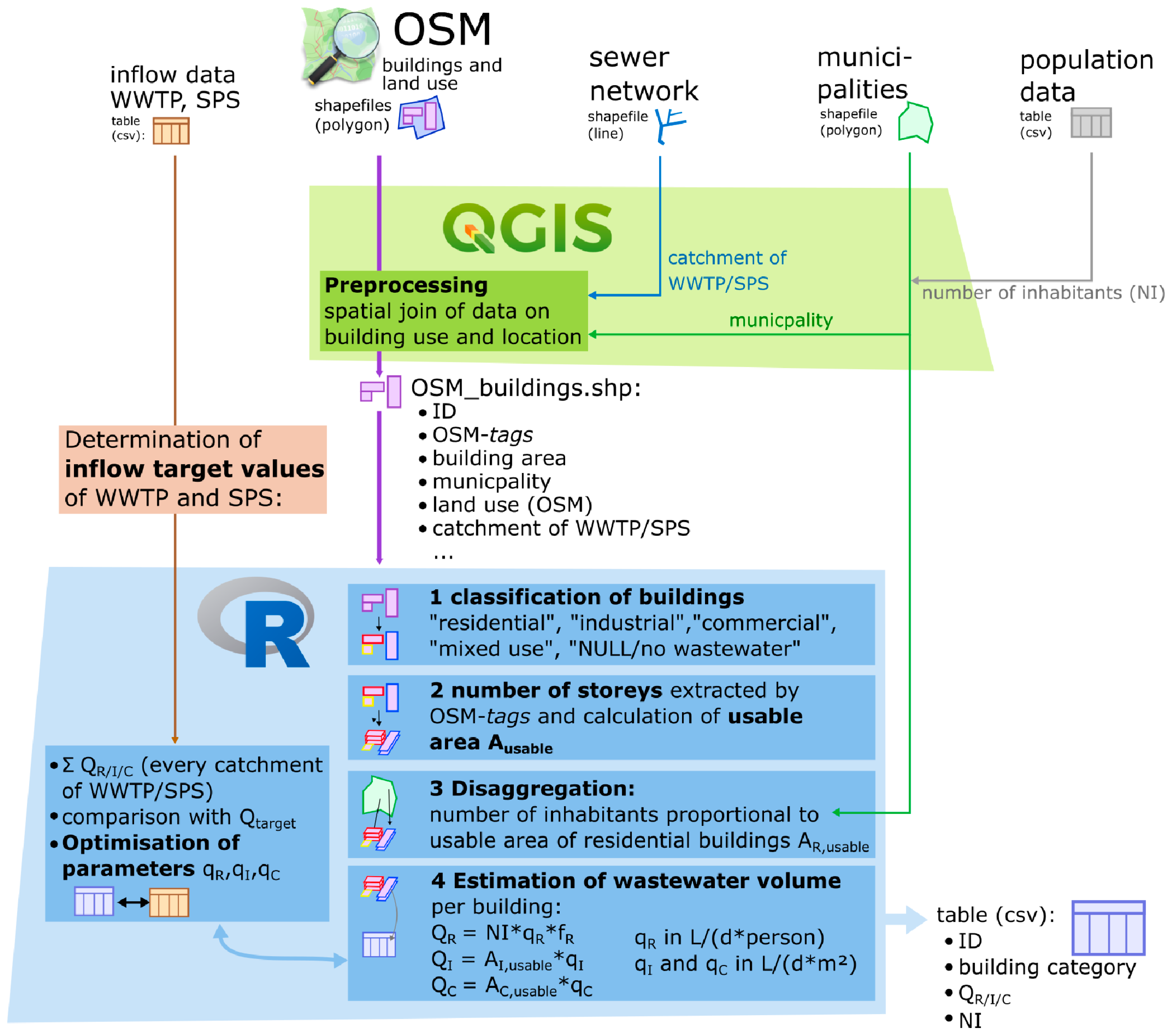
2.2. Generation of Wastewater Volume per Building
- OSM tags of land-use polygons on which a building is located.
- If none of the former is stated: land-use information derived from ALKIS.
2.3. Optimization of Parameters
2.4. Application Example: Aggregation at LUP Level
3. Results and Discussion
3.1. Classification of Buildings
3.2. Determination of the Inflow Target Value
3.3. Parameter Optimizing Process
- qR = 93.0 L/(person*d);
- qC = 2.4 L/(m²*d);
- qI = 0.6 L/(m²*d).
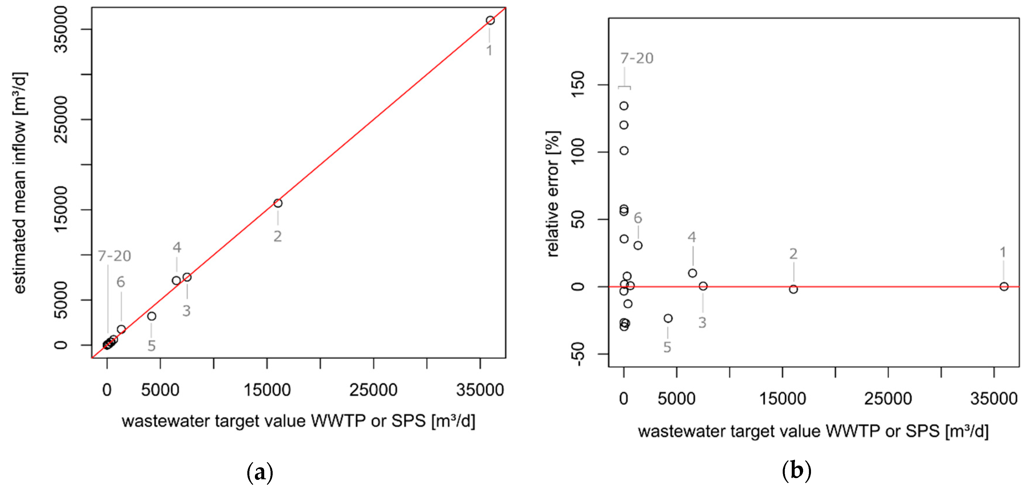
3.4. Calculated Wastewater Volume
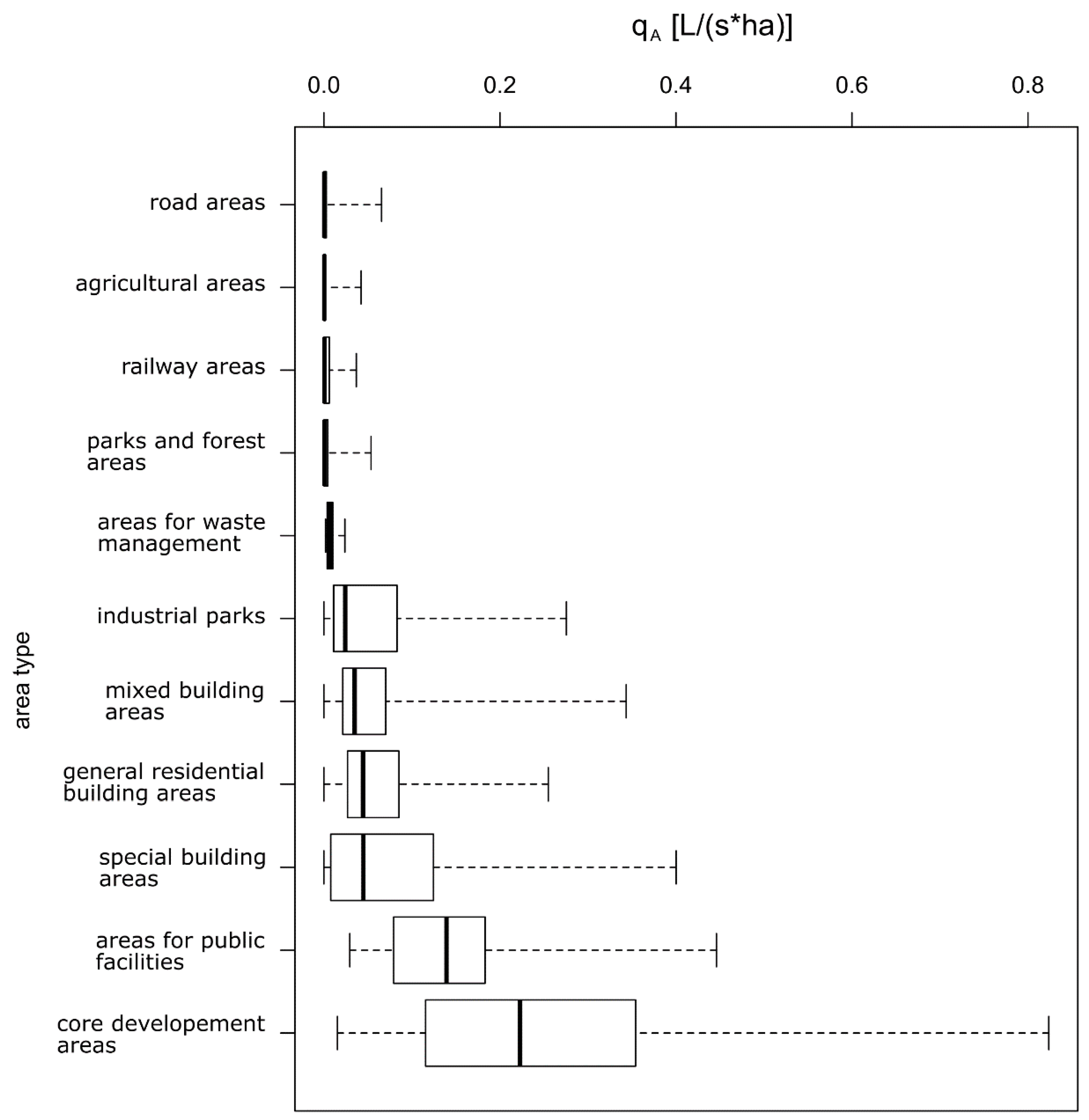
3.5. Application Examples LUP and Urban Wastewater Management
4. Conclusions
Author Contributions
Funding
Acknowledgments
Conflicts of Interest
Appendix A
| N | NI | NI*fR | AR (m²) | AI (m²) | AC (m²) | 1st Q. DW (m³/d) | Mean DW (m³/d) | LTA WW (m³/d) |
|---|---|---|---|---|---|---|---|---|
| 1 | 234,844 | 234,372 | 14,365,079 | 1,660,316 | 5,458,696 | 35,947 | 38,964 | - |
| 2 | 101,706 | 101,769 | 6,194,405 | 371,115 | 2,497,618 | 16,034 | 17,764 | - |
| 3 | 47,755 | 47,373 | 3,133,414 | 900,494 | 1,079,482 | 7501 | 8080 | - |
| 4 | 52,353 | 52,353 | 3,136,566 | 108,951 | 915,023 | 6498 | 7090 | - |
| 5 | 22,470 | 22,470 | 1,296,892 | 142,960 | 426,274 | 4189 | 4329 | - |
| 6 | 5549 | 5549 | 319,759 | 114,006 | 480,849 | 1338 | 1654 | - |
| 7 | 4629 | 4568 | 399,937 | 19,677 | 74,456 | 612 | 706 | - |
| 8 | 2880 | 2880 | 199,243 | 39,818 | 20,960 | 391 | 439 | - |
| 9 | 3238 | 3022 | 294,551 | 33,333 | 12,372 | n.a | n.a | 306 |
| 10 | 535 | 499 | 49,360 | 0 | 33,654 | n.a | n.a | 176 |
| 11 | 720 | 624 | 109,380 | 0 | 0 | 57 | 73 | - |
| 12 | 250 | 200 | 45,851 | 0 | 449 | 28 | 34 | - |
| 13 | 343 | 320 | 27,872 | 5271 | 8046 | 26 | 34 | - |
| 14 | 212 | 170 | 40,671 | 179 | 7974 | 26 | 30 | - |
| 15 | 105 | 77 | 15,540 | 4201 | 0 | 13 | 15 | - |
| 16 | 148 | 118 | 21,999 | 5111 | 771 | n.a | n.a | 10 |
| 17 | 162 | 151 | 14,736 | 0 | 0 | 6 | 8 | - |
| 18 | 100 | 93 | 9054 | 222 | 0 | 4 | 5 | - |
| 19 | 40 | 37 | 3211 | 0 | 496 | n.a | n.a | 3 |
| 20 | 48 | 42 | 7113 | 0 | 0 | 4 | 4 | - |
Appendix B
| N | Qtarget (m³/d) | Qgen (m³/d) | Err (m³/d) | Rel. Err (%) |
|---|---|---|---|---|
| 1 | 35,947 | 35,992 | 45 | 0.1 |
| 2 | 16,034 | 15,734 | −300 | −1.9 |
| 3 | 7501 | 7537 | 36 | 0.5 |
| 4 | 6498 | 7153 | 655 | 10.0 |
| 5 | 4189 | 3206 | −983 | −23.5 |
| 6 | 1338 | 1748 | 410 | 30.7 |
| 7 | 612 | 617 | 5 | 0.8 |
| 8 | 391 | 341 | −50 | −12.7 |
| 9 | 306 | 330 | 24 | 7.8 |
| 10 | 176 | 128 | −48 | −27.2 |
| 11 | 57 | 58 | 1 | 1.8 |
| 12 | 28 | 20 | −8 | −29.6 |
| 13 | 26 | 52 | 26 | 101.1 |
| 14 | 26 | 35 | 9 | 35.5 |
| 15 | 13 | 10 | −3 | −26.6 |
| 16 | 10 | 16 | 6 | 57.8 |
| 17 | 6 | 14 | 8 | 134.4 |
| 18 | 4 | 9 | 5 | 120.2 |
| 19 | 3 | 4 | −1 | 3.3 |
| 20 | 4 | 5 | 1 | 55.9 |
Appendix C
References
- Navin, P.K.; Mathur, Y.P. Layout and Component Size Optimization of Sewer Network Using Spanning Tree and Modified PSO Algorithm. Water Resour. Manag. 2016, 30, 3627–3643. [Google Scholar] [CrossRef]
- Zhao, W.; Beach, T.H.; Rezgui, Y. Optimization of Potable Water Distribution and Wastewater Collection Networks: A Systematic Review and Future Research Directions. IEEE Trans. Syst. Man Cybern. Syst. 2016, 46, 659–681. [Google Scholar] [CrossRef]
- Duque, N.; Duque, D.; Saldarriaga, J. A new methodology for the optimal design of series of pipes in sewer systems. J. Hydroinform. 2016, 18, 757–772. [Google Scholar] [CrossRef]
- Steele, J.C.; Mahoney, K.; Karovic, O.; Mays, L.W. Heuristic Optimization Model for the Optimal Layout and Pipe Design of Sewer Systems. Water Resour. Manag. 2016, 30, 1605–1620. [Google Scholar] [CrossRef]
- Campos, H.M.; von Sperling, M. Estimation of domestic wastewater characteristics in a developing country based on socio-economic variables. Water Sci. Technol. 1996, 34, 71–77. [Google Scholar] [CrossRef]
- Willuweit, L.; O’Sullivan, J.J. A decision support tool for sustainable planning of urban water systems: Presenting the Dynamic Urban Water Simulation Model. Water Res. 2013, 47, 7206–7220. [Google Scholar] [CrossRef]
- Deutsche Vereinigung für Wasserwirtschaft, Abwasser und Abfall. Hydraulische Bemessung und Nachweis von Entwässerungssystemen; DWA: Hennef, Germany, 2006; p. 118. [Google Scholar]
- Schiller, G.; Bräuer, A. GIS-basierte kleinräumige Schätzung von Planungsparametern zur Unterstützung der strategischen Siedlungs- und Infrastrukturplanung. In Angewandte Geoinformatik 2013: Beiträge zum 25. AGIT-Symposium Salzburg; Strobl, J., Blaschke, T., Griesebner, G., Zagel, B., Eds.; Wichmann: Berlin, Germany, 2013; pp. 628–637. [Google Scholar]
- Bakillah, M.; Liang, S.; Mobasheri, A.; Jokar Arsanjani, J.; Zipf, A. Fine-resolution population mapping using OpenStreetMap points-of-interest. Int. J. Geogr. Inf. Sci. 2014, 28, 1940–1963. [Google Scholar] [CrossRef]
- Kunze, C. Nutzung semantischer Informationen aus OSM zur Beschreibung des Nichtwohnnutzungsanteils in Gebäudebeständen. BSc Thesis, Technische Universität Dresden, Dresden, Germany, 2013. [Google Scholar]
- Fan, H.; Zipf, A.; Fu, Q. Estimation of Building Types on OpenStreetMap Based on Urban Morphology Analysis. In Connecting a Digital Europe through Location and Place; Huerta, J., Schade, S., Granell, C., Eds.; Springer: Cham, Switzerland, 2014; pp. 19–35. [Google Scholar]
- Goodchild, M.F. Citizens as sensors: The world of volunteered geography. GeoJournal 2007, 69, 211–221. [Google Scholar] [CrossRef]
- Haklay, M. How Good is Volunteered Geographical Information? A Comparative Study of OpenStreetMap and Ordnance Survey Datasets. Environ. Plann. B Plann. Des. 2010, 37, 682–703. [Google Scholar] [CrossRef]
- Koukoletsos, T.; Haklay, M.; Ellul, C. Assessing Data Completeness of VGI through an Automated Matching Procedure for Linear Data. Trans. GIS 2012, 16, 477–498. [Google Scholar] [CrossRef]
- Bégin, D.; Devillers, R.; Roche, S. Assessing volunteered geographic information (VGI) quality based on contributors’ mapping behaviours. Int. Arch. Photogramm. Remote Sens. Spatial Inf. Sci. 2013, XL-2/W1, 149–154. [Google Scholar]
- Dorn, H.; Törnros, T.; Zipf, A. Quality Evaluation of VGI Using Authoritative Data—A Comparison with Land Use Data in Southern Germany. Int. J. Geo-Inf. 2015, 4, 1657–1671. [Google Scholar] [CrossRef]
- Meek, S.; Jackson, M.; Leibovici, D. A Flexible Framework for Assessing the Quality of Crowdsourced Data. In Proceedings of the Agile2014, Orlando, FL, USA, 28 July–1 August 2014. [Google Scholar]
- Leibovici, D.; Rosser, J.; Hodges, C.; Evans, B.; Jackson, M.; Higgins, C. On Data Quality Assurance and Conflation Entanglement in Crowdsourcing for Environmental Studies. Int. J. Geo-Inf. 2017, 6, 78. [Google Scholar] [CrossRef]
- Senaratne, H.; Mobasheri, A.; Ali, A.L.; Capineri, C.; Haklay, M. A review of volunteered geographic information quality assessment methods. Int. J. Geogr. Inf. Sci. 2017, 31, 139–167. [Google Scholar] [CrossRef]
- Hecht, R.; Kunze, C.; Hahmann, S. Measuring Completeness of Building Footprints in OpenStreetMap over Space and Time. Int. J. Geo-Inf. 2013, 2, 1066–1091. [Google Scholar] [CrossRef]
- Törnros, T.; Dorn, H.; Hahmann, S.; Zipf, A. Uncertainties of completeness measures in OpenStreetMap - a case study for buildings in a medium sized German city. ISPRS Ann. Photogramm. Remote Sens. Spatial Inf. Sci. 2015, II-3/W5, 353–357. [Google Scholar]
- Zhou, Q. Exploring the relationship between density and completeness of urban building data in OpenStreetMap for quality estimation. Int. J. Geogr. Inf. Sci. 2018, 32, 257–281. [Google Scholar] [CrossRef]
- Fan, H.; Zipf, A.; Fu, Q.; Neis, P. Quality assessment for building footprints data on OpenStreetMap. Int. J. Geogr. Inf. Sci. 2014, 28, 700–719. [Google Scholar] [CrossRef]
- Werder, S.; Kieler, B.; Sester, M. Semi-Automatic Interpretation of Buildings and Settlement Areas in User-Generated Spatial Data. In Proceedings of the 18th SIGSPATIAL International Conference, San Jose, CA, USA, 2–5 November 2010. [Google Scholar]
- Alhamwi, A.; Medjroubi, W.; Vogt, T.; Agert, C. OpenStreetMap data in modelling the urban energy infrastructure: A first assessment and analysis. Energy Procedia 2017, 142, 1968–1976. [Google Scholar] [CrossRef]
- Fazeli, H.R.; Nor Said, M.; Amerudin, S.; Abd Rahman, M.Z. A study of volunteered geographic information (VGI) assessment methods for flood hazard mapping: A review. J. Teknol. 2015, 75. [Google Scholar] [CrossRef]
- Horita, F.E.A.; Degrossi, L.C.; de Assis, L.F.G.; Zipf, A.; de Albuquerque, J.P. The use of Volunteered Geographic Information (VGI) and Crowdsourcing in Disaster Management: A Systematic Literature Review. In Proceedings of the AMCIS 2013, Chicago, IL, USA, 15–17 August 2013. [Google Scholar]
- Medjroubi, W.; Müller, U.P.; Scharf, M.; Matke, C.; Kleinhans, D. Open Data in Power Grid Modelling: New Approaches Towards Transparent Grid Models. Energy Rep. 2017, 3, 14–21. [Google Scholar] [CrossRef]
- Fonte, C.C.; Bastin, L.; See, L.; Foody, G.; Lupia, F. Usability of VGI for validation of land cover maps. Int. J. Geogr. Inf. Sci. 2015, 29, 1269–1291. [Google Scholar] [CrossRef]
- Connors, J.P.; Lei, S.; Kelly, M. Citizen Science in the Age of Neogeography: Utilizing Volunteered Geographic Information for Environmental Monitoring. Ann. Am. Assoc. Geogr. 2012, 102, 1267–1289. [Google Scholar] [CrossRef]
- Baloian, N.; Frez, J.; Pino, J.A.; Zurita, G. Efficient Planning of Urban Public Transportation Networks. In Proceedings of the 9th international conference, UCAmI 2015, Puerto Varas, Chile, 1–4 December 2015. [Google Scholar]
- Dimond, M.; Brenig-Jones, D.; Taylor, N. Exploiting OpenStreetMap topology to aggregate and visualise public transport demand. In Proceedings of the GISRUK 2017, Manchester, UK, 18–21 April 2017. [Google Scholar]
- Kunze, C.; Hecht, R. Semantic enrichment of building data with volunteered geographic information to improve mappings of dwelling units and population. Comput. Environ. Urban. 2015, 53, 4–18. [Google Scholar] [CrossRef]
- Blumensaat, F.; Wolfram, M.; Krebs, P. Sewer model development under minimum data requirements. Environ. Earth Sci. 2012, 65, 1427–1437. [Google Scholar] [CrossRef]
- Mair, M.; Zischg, J.; Rauch, W.; Sitzenfrei, R. Where to Find Water Pipes and Sewers?—On the Correlation of Infrastructure Networks in the Urban Environment. Water 2017, 9, 146. [Google Scholar] [CrossRef]
- Küpper, P. Abgrenzung und Typisierung ländlicher Räume. Available online: https://literatur.thuenen.de/digbib_extern/dn057783.pdf (accessed on 21 February 2020).
- Grundsätze für die Abwasserentsorgung in ländlich strukturierten Gebieten. In Abwassertechnische Vereinigung; Ges. zur Förderung der Abwassertechnik: Hennef, Germany, 1997; p. 200.
- WWAV. Kennziffern. Available online: https://www.wwav.de/ueber-uns/kennziffern/ (accessed on 21 September 2019).
- Geofabrik GmbH. Available online: https://download.geofabrik.de/europe/germany/mecklenburg-vorpommern.html (accessed on 21 May 2019).
- Ballatore, A.; Bertolotto, M.; Wilson, D.C. Geographic knowledge extraction and semantic similarity in OpenStreetMap. Knowl. Inf. Syst. 2013, 37, 61–81. [Google Scholar] [CrossRef]
- Amt für Geoinformation, Vermessungs- und Katasterwesen. Available online: https://www.laiv-mv.de/Geoinformation/ (accessed on 21 November 2019).
- R Development Core Team. R: A Language and Environment for Statistical Computing; R Foundation for Statistical Computing: Vienna, Austria, 2011. [Google Scholar]
- QGIS Python Plugins Repository. Available online: https://plugins.qgis.org/plugins/WaterNetAnalyzer-master/ (accessed on 7 October 2019).
- Nelder, J.A.; Mead, R. A Simplex Method for Function Minimization. Comput. J. 1965, 7, 308–313. [Google Scholar] [CrossRef]
- Götz, M.; Zipf, A. OpenStreetMap in 3D—Detailed Insights on the Current Situation in Germany. In Proceedings of the International AGILE’2012 Conference, Avignon, France, 24–27 April 2012. [Google Scholar]
- WMS Digitale Topographische Webkarte M-V. Available online: https://www.geoportal-mv.de/geomis/Query/ShowCSWInfo.do?fileIdentifier=94692fd3-8908-449d-b54a-6e070f2121a9 (accessed on 22 November 2019).
- Available online: https://taginfo.openstreetmap.org/keys/building (accessed on 22 November 2019).
- Deutscher Wetterdienst (DWD). Klimadaten Deutschland—Monats- und Tageswerte. Available online: https://www.dwd.de/DE/leistungen/klimadatendeutschland/klarchivtagmonat.html (accessed on 5 February 2020).
- Cahoon, L.B.; Hanke, M.H. Rainfall effects on inflow and infiltration in wastewater treatment systems in a coastal plain region. Water Sci. Technol. 2017, 75, 1909–1921. [Google Scholar] [CrossRef]
- Pellerin, B.A.; Wollheim, W.M.; Feng, X.; Vörösmarty, C.J. The application of electrical conductivity as a tracer for hydrograph separation in urban catchments. Hydrol. Process. 2008, 22, 1810–1818. [Google Scholar] [CrossRef]
- Tränckner, S.; Stapel, C.; Cramer, M.; Tränckner, J. Einfluss kleiner Kläranlagen auf die Gewässerbeschaffenheit hinsichtlich Phosphat im norddeutschen ländlichen Raum. KW Korrespondenz Wasserwirtschaft 2019, 12, 159–165. [Google Scholar]
- Singh, A.; Sawant, M.; Kamble, S.J.; Herlekar, M.; Starkl, M.; Aymerich, E.; Kazmi, A. Performance evaluation of a decentralized wastewater treatment system in India. Environ. Sci. Pollut. Res. 2019, 26, 21172–21188. [Google Scholar] [CrossRef] [PubMed]
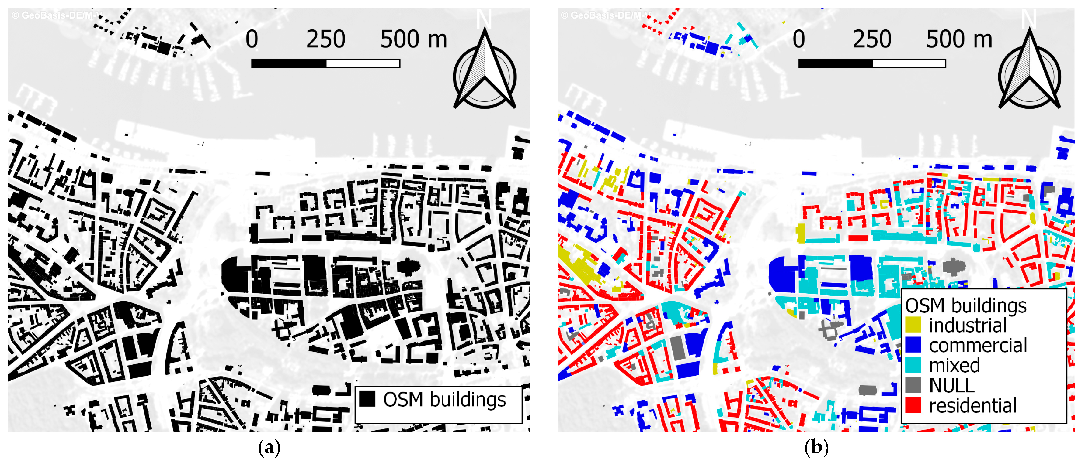
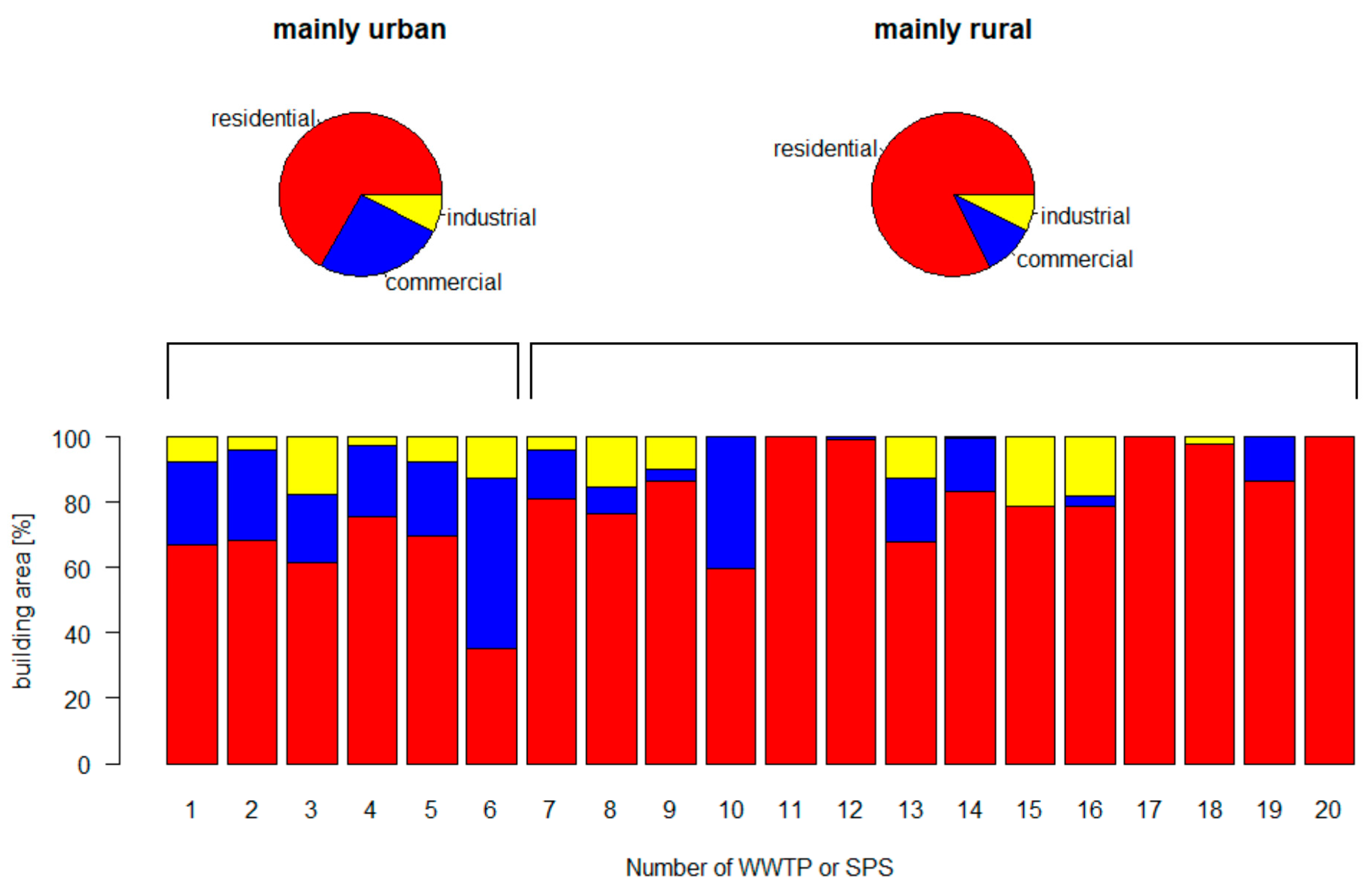
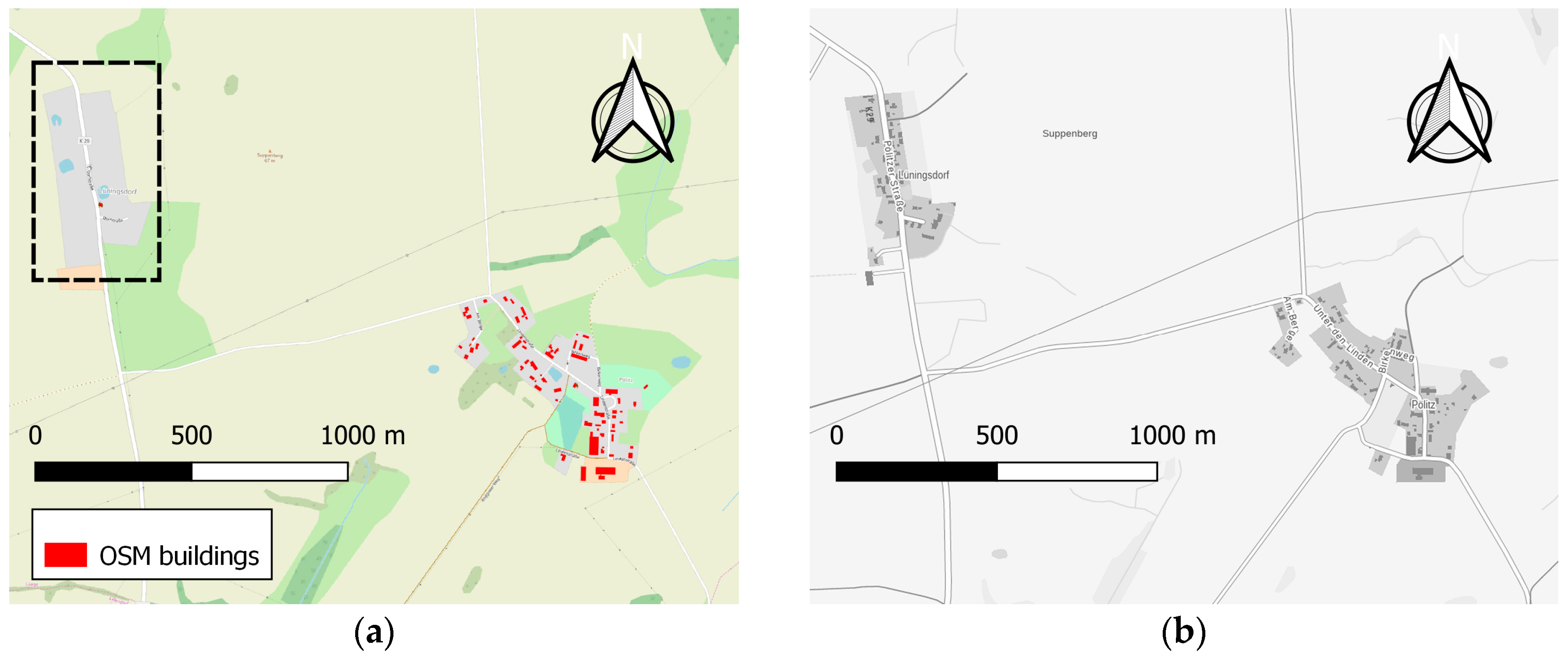
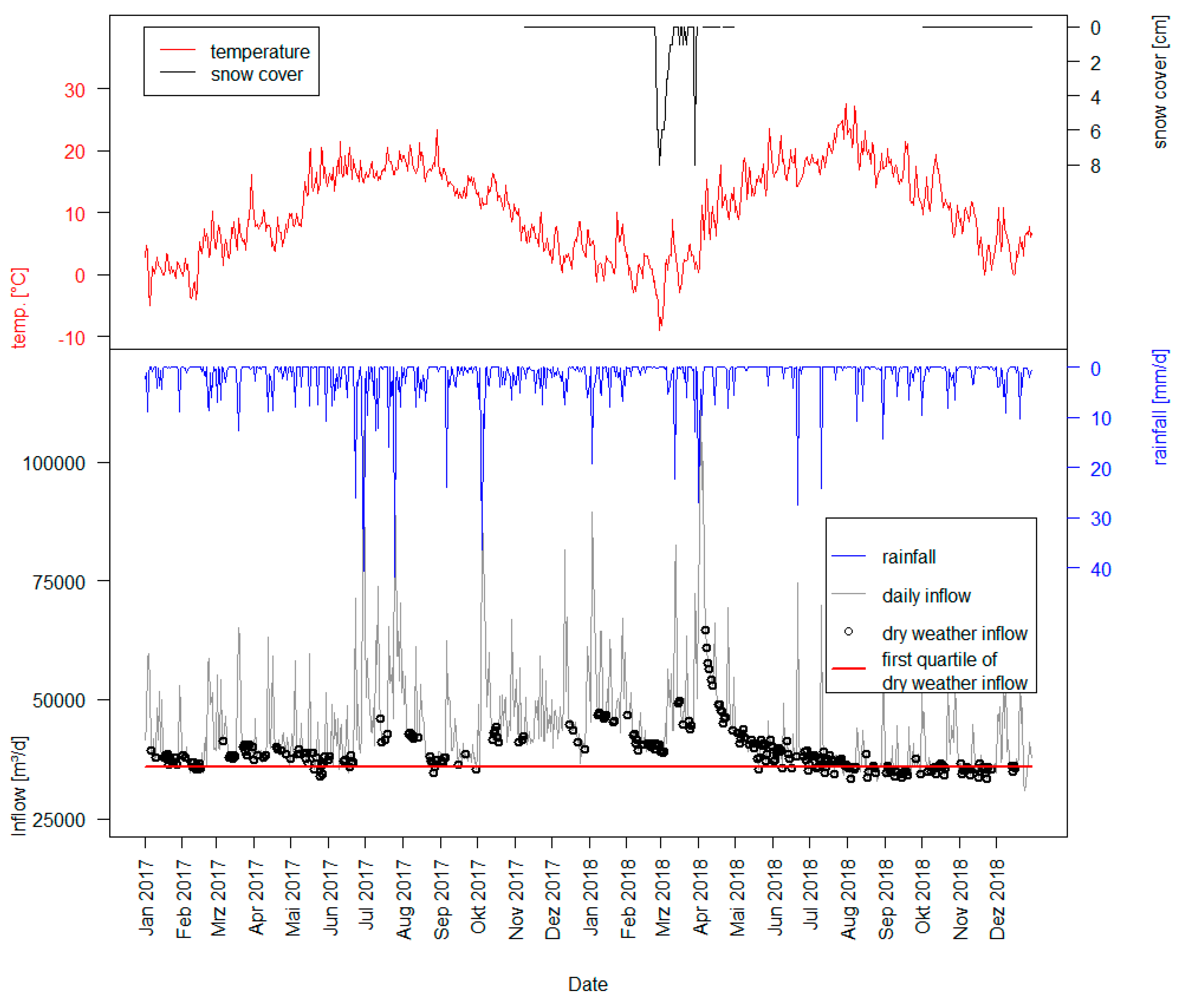
| Residential | Commercial | Industrial | NULL |
|---|---|---|---|
| Apartments | airport_terminal | cowshed | abandoned |
| Detached | commercial | Dock | allotments |
| Dormitory | doctor | Farm | cabin |
| House | hall | greenhouse | carport |
| Private | hospital | industrial | collapsed |
| Residential | hotel | manufacture | container |
| Semi | kiosk | Mill | construction |
| semidetached_house | museum | Stable | garages |
| Terrace | office | Storage | gasometer |
| Yes | public | Sty | ruins |
| … | … | … | … |
| Optimization Method | qR L/(person*d) | qC L/(m²*d) | qI L/(m²*d) | Area |
|---|---|---|---|---|
| Linear regression | 80.1 | 2.7 | 1.5 | WWTPs without central WWTP Rostock/ mainly rural area |
| Nelder–Mead | 61.5 | 3.1 | 2.9 | |
| Linear regression | 93.6 | 2.4 | 0.6 | Pumping stations/mainly urban areas |
| Nelder–Mead | 93.6 | 2.4 | 0.6 | |
| Linear regression | 93.0 | 2.4 | 0.6 | WWTPs including the central WWTP Rostock (entire study area) |
| Nelder–Mead | 93.1 | 2.4 | 0.6 |
© 2020 by the authors. Licensee MDPI, Basel, Switzerland. This article is an open access article distributed under the terms and conditions of the Creative Commons Attribution (CC BY) license (http://creativecommons.org/licenses/by/4.0/).
Share and Cite
Schilling, J.; Tränckner, J. Estimation of Wastewater Discharges by Means of OpenStreetMap Data. Water 2020, 12, 628. https://doi.org/10.3390/w12030628
Schilling J, Tränckner J. Estimation of Wastewater Discharges by Means of OpenStreetMap Data. Water. 2020; 12(3):628. https://doi.org/10.3390/w12030628
Chicago/Turabian StyleSchilling, Jannik, and Jens Tränckner. 2020. "Estimation of Wastewater Discharges by Means of OpenStreetMap Data" Water 12, no. 3: 628. https://doi.org/10.3390/w12030628
APA StyleSchilling, J., & Tränckner, J. (2020). Estimation of Wastewater Discharges by Means of OpenStreetMap Data. Water, 12(3), 628. https://doi.org/10.3390/w12030628


