Article

On the Hydrodynamic Behavior of the Changed River–Lake Relationship in a Large Floodplain System, Poyang Lake (China)

1
MCC Huatian Engineering & Technology Corporation, 18 East Fuchunjiang Street, Nanjing 210005, China
2
Key Laboratory of Watershed Geographic Sciences, Nanjing Institute of Geography and Limnology, Chinese Academy of Sciences, 73 East Beijing Road, Nanjing 210008, China
*
Author to whom correspondence should be addressed.
Water 2020, 12(3), 626; https://doi.org/10.3390/w12030626
Submission received: 8 January 2020 / Revised: 10 February 2020 / Accepted: 24 February 2020 / Published: 26 February 2020
(This article belongs to the Section Hydrology)

Abstract

:
Poyang lake floodplains are hydrologically complex and dynamic systems which exhibit dramatic intra-annual wetting and drying. The flow regime of the Yangtze River was previously known to play an important role in affecting Poyang Lake and its extremely productive floodplains (river–lake relationship). The recent severe declines and recessions in the lake are closely linked to the changed river–lake relationship, resulting in significant hydrological, ecological, and economic problems. This study aims to examine the spatiotemporal heterogeneity of the floodplain hydrodynamic behaviors with respect to impacts of the changed river–lake relationship, characterized by the lake water level, inundation area, and inundation duration based on a floodplain hydrodynamic model of Poyang Lake, and to further quantify the severity of dryness recently endured since 2000. Simulation results show that, in general, the current modified river–lake relationship is more likely to affect the hydrological seasonality of the floodplain system since 2000, relative to the flooding and drying cycles during past decades (1953–2000). The present hydrodynamic behaviors suffered significant change due to the greatest interference from the altered river–lake relationship, particularly for the falling period in October. On average, the floodplain water level and inundation duration decreased by 6 m and 12 days during October, respectively. Additionally, the highest monthly shrinkage rate in floodplain inundation shifted from the period of October–November to September–October, with the mean inundation area decreasing by around 50%, demonstrating an advanced and prolonged dry condition. The spatial responses of the hydrodynamics in the low-slope floodplains are most likely to be affected by the dynamic river–lake relationship, as expected. This study assessed the effects of the altered river–lake relationship on the hydrological regime of the Poyang Lake floodplains in terms of spatiotemporal distributions and changing processes for the periodic inundated behavior, which can support the relevant study of the subsequent ecological effects on the wetlands.

1. Introduction

Extensive floodplains are usually associated with large rivers, seasonal inundated lakes, and seas. Evidence accumulated from the research regarding anthropogenic interventions and climate change demonstrates that floodplains are presently more prone to external forces, and they are recognized as globally threatened ecosystems [1,2]. In large floodplain systems, hydrodynamic behaviors have gained considerable attention and worldwide recognition, and they play an important role in controlling the mixing that provides critical insights into the transport of water, ecosystem, dissolved matter, and sediments [3,4,5].
Hydrological and hydrodynamic regimes strongly influence the biotic diversity of river ecosystems by structuring the physical habitat within river channels and associated floodplains [6]. The inundation area, water level, water flow paths, and residence time of floodplains are greatly modified by the passage of flooding water through surrounding off-stream compartments, due to the complex water exchange mechanisms between floodplains and rivers [7,8]. Large floodplains play a significant role in the fauna/flora composition. Moreover, the constancy of their hydrological regimes ensures the stability of the local ecosystem [9,10,11,12,13]. In recent years, the water security and eco-systematic safety of floodplains were severely threatened by the altered hydrological regime linking the local and global dynamics (climate change and more intense human modifications) [1,14]. Therefore, the extent and intensity assessment regarding the hydrological and hydrodynamic behaviors in large-scale floodplains is vitally important for the assessment of functions of seasonally inundated rivers, lakes, and wetlands.
Although hydrodynamic properties were identified as crucial to many functional aspects of lake–floodplain systems, the assessment of such complex systems remains a challenge. The hydrologic instrumentation of large floodplains makes the in situ collection of detailed data impractical; therefore, examinations of the hydrological regime are usually limited to a small number of plots with continuous records [9,15], while such records rarely provide sufficient data of the spatial extent to examine hydrological and ecological characteristics across the breadth of a large floodplain. In addition, the profiles of a digital elevation model (DEM) are either hardly continuously available or at a vertical coarse resolution, which cannot accurately represent the subtle variations in the floodplain. Due to these difficulties, few attempts were conducted to explore the changes of the hydrological regime in floodplains over an extended time scale. Many researchers attempted to apply various methods to overcome these difficulties. For example, the remote sensing technique is an increasingly efficient approach for monitoring floodplain hydrology and environments [16,17,18,19,20]. Although remote sensing is efficient in capturing the spatial distribution and changing processes of inundation, its potential is limited due to the high demand of time frequency (e.g., screening for cloud-free images) and long-term series. The spatial and temporal changes in a hydrological regime cannot be continuously and regularly monitored by remote sensing and may sometimes even be totally undetected [21]. Additionally, the remote sensing data usually restrict tracing the daily or weekly (i.e., short-term) variation of water area due to the coarse temporal resolution and, hence, create high uncertainty for estimating monthly and annual variations in the water area of lakes [17,18].
Physical-based modeling of lake water level and inundation area provides opportunities for interpolating temporal data gaps obtained from remote sensing and routine monitoring data. Numerous studies attempted to investigate the hydrological changes of floodplain seasonality using hydrodynamic models. For example, Townsend [22] employed a flood inundation model to simulate the hydrological regime changes of the Roanoke River floodplain in North Carolina (United States). Zerger and Wealands [23] proved that spatially explicit hydrodynamic models (represented by a two-dimensional (2D) model MIKE 21) play an important role in natural hazard risk reduction by providing abundant and reliable time-series inundation information (e.g., the onset time, duration, and passing) in Australia. In addition, the effects of physical characteristics on hydrological regimes could also be illustrated for specific simulation scenarios, which cannot be achieved with only remote sensing. May et al. [24] simulated the influences of the tide, wind, and river flow from the water regime of South San Francisco Bay (Unites States) on the phytoplankton population using a developed hydrodynamic model. Chatterjee et al. [25] applied hydrodynamic models (MIKE 11 and MIKE FLOOD) to simulate the flooding and emptying processes under different scenarios (e.g., flood events and gate operations) in the Elbe River (central Europe). In general, given the advantages of hydrodynamic models in capturing the spatial and temporal variations of hydrological regimes, as well as their flexible ability to test various simulation scenarios, hydrodynamic models are usually employed as an effective and enhanced functional way to illustrate the variations and to distinguish specific impact on the hydrological regime for large lake–floodplain systems from possible causes.
Poyang Lake is the largest freshwater lake in China, and its wetland is also recognized as having a pivotal position in the world with great international importance [5]. The lake is located at the south bank of the middle reaches of the Yangtze River, and it is one of the few lakes that remain naturally connected to the Yangtze River. Another similar accompanying lake, Dongting Lake, located about 500 km upstream from Poyang Lake, is the second largest freshwater lake in China. Complex hydrological and hydrodynamic interactions between the lake and the Yangtze River play an important role in affecting annual and seasonal lake level variations [18]. Poyang Lake receives water inflows from its catchment, and discharges to the Yangtze River at Hukou (the junction of the Yangtze River and Poyang Lake) in the north. The combined effects of catchment inflows and the interaction with the river result in a considerable seasonal variation in the lake water levels [8]. The lake’s floodplains are the most extensive in the Yangtze River basin [8]. The complex river–lake interactions between Poyang Lake and the Yangtze River were extensively investigated [26,27,28,29,30,31,32]. Human activities are the major factor for the decrease in discharges of the Yangtze River in the 2000s [33]. For example, the operation of the Three Gorges Dam began in 2003 and aggravated the changes in the Yangtze River discharge pattern on an intra-annual cycle, decreasing in the high-flow and increasing in the low-flow [30,32,34,35]. Changes in the Yangtze River discharge in the last decade significantly influenced the inter-relationship alteration between the Yangtze River and Poyang Lake [28,30,32]. The altered river–lake relationship can affect the connected natural lakes directly. Hence, many previous researchers linked the recent dramatic declines and recessions of Poyang Lake to the changed river–lake relationship. For example, previous studies showed that the lake water level declined significantly, and that the lake also suffered frequent drought events in recent years [31,36,37]. That is because the dry seasons of the lake are advanced and prolonged since 2000 [36,38,39], with accelerated falling water during autumn [29,37,40]. Climate change in the Yangtze River basin since the 1990s is possibly the precondition for the advance of the lake dry season, which is further aggravated by the effects of the Three Gorges Dam in the 2000s [39]. Given these backgrounds, the subsequent dramatic water area shrinkage and the water level recession of Poyang Lake would result in enlarged floodplain regions and a prolonged growth period, which could lead to unexpected alterations in the wetland processes [13,41,42,43].
Although the impacts of the river–lake relationship on the hydrological and ecological processes of Poyang Lake were extensively investigated, few studies focused on the hydrodynamic behaviors of the lake’s floodplains in terms of the inundation properties. More knowledge regarding the floodplain hydrology of Poyang Lake is of great scientific merit in understanding the potential links between the hydrological regime of the floodplains and the wetland ecological functioning. It may further provide a theoretical basis for the construction of a hydraulic dam near the outlet channel of the lake [44]. Consequently, a quantitative interpretation of the intra-annual hydrological regime pattern of the Poyang Lake floodplains will benefit the sustainable hydrological processes and wetland management within the lake–floodplain system. A further motivation for this study is curiosity, as the spatiotemporal changes of Poyang Lake inundation behavior remain to be investigated in detail. The major purpose of this study is to assess the spatial and temporal floodplain hydrological processes in response to the changed river–lake relationship using the floodplain hydrodynamic model proposed by Li et al. [45]. The primary objectives are to examine the effects of the changed river–lake relationship on the temporal and spatial patterns in the hydrological regime in the Poyang Lake floodplains characterized by inundation area, water level, and inundation duration.

2. Materials and Methods
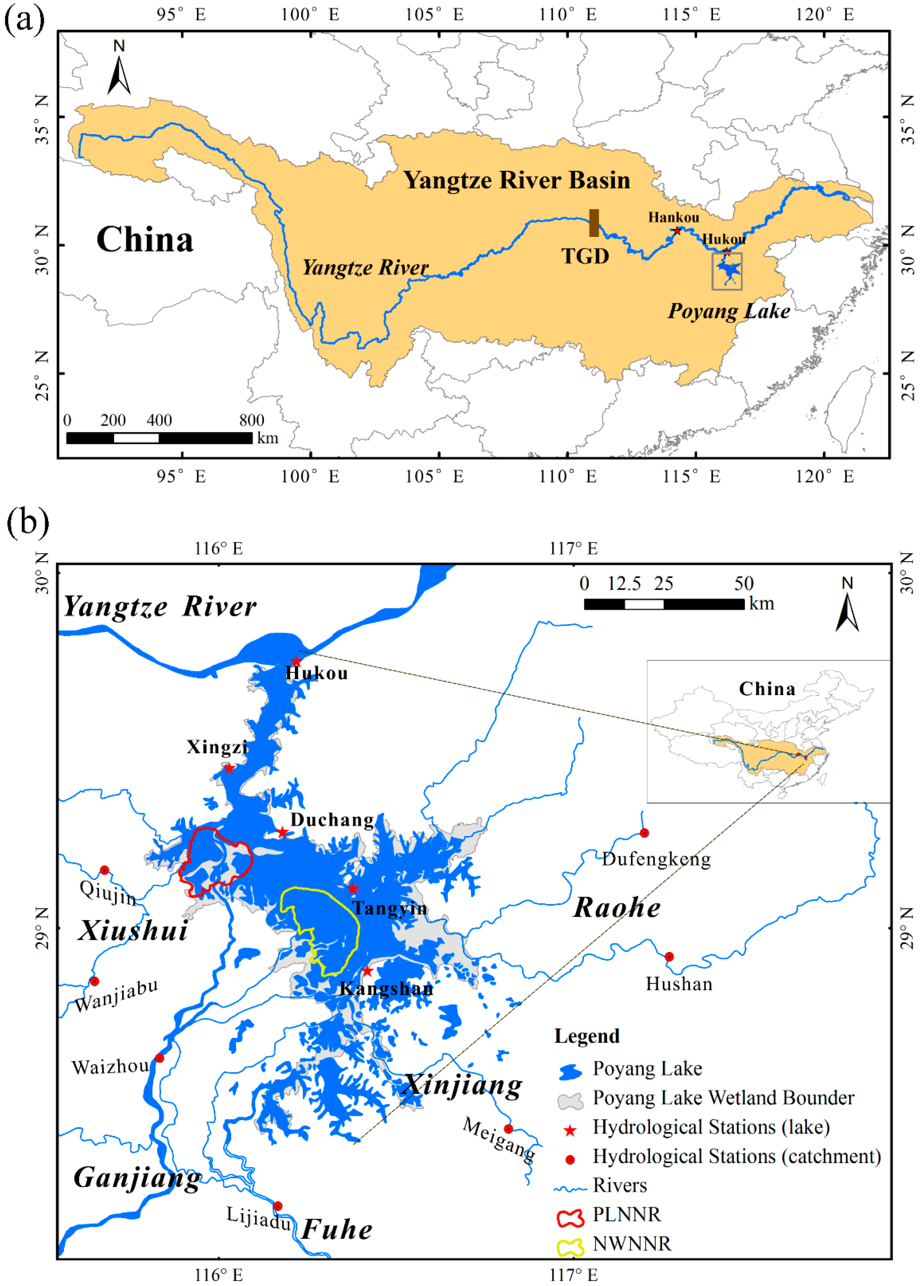
2.1. Study Area

Poyang Lake (28°24′–29°46′ north (N); 115°49′–116°46′ east (E)) is located in the middle reaches of the Yangtze River and is naturally connected to the Yangtze River via a narrow channel in the north at Hukou (Figure 1a). The lake receives surface inflows (i.e., through five major rivers Xiushui, Ganjiang, Fuhe, Xinjiang, and Raohe) from the local catchments of 16.22 × 10⁴ km2 [37] and discharges into the Yangtze River (Figure 1b). In addition, backflow from the Yangtze River to Poyang Lake occurs frequently due to their water level gradient in different flood seasons [21]. Generally, the lake bottom elevation decreases from south to north, with an absolute difference of about 6.5 m [45]. The annual precipitation is around 1654 mm, and the annual potential evapotranspiration is 1049 mm, resulting from a subtropical wet climate [37]. In response to the annual precipitation cycle, about 59.1% of the annual discharge is received from March to June, with only 13.7% from October to January [46]. The lake’s floodplains accommodate a wide range of migrating waterfowls during winter and they are ecologically important. The Poyang Lake wetland is famous for its abundant biodiversity, and it was registered as one of the world’s most important wetlands in 1992 [13].
The changes in the lake level, area, and volume exhibit obvious seasonal and inter-annual variations [8]. During the wet season (June to August), the lake level rises quickly, and the floodplain inundation expands rapidly (over 3000 km2). During the dry season (December to February), the lake level drops rapidly, and the water body shrinks to a small area (less than 1000 km2), with extensive floodplains exposed [8,17,47,48]. At extremely low water levels, active water flows are constrained to the main lake’s channels, and the lake behaves more so like a river. Overall, the hydrological regime of the Poyang Lake floodplains is particularly complex because the dramatic inter/intra-annual fluctuations in water level and water area are associated with dynamic river–lake interactions. The floodplains were developed into internationally recognized wetlands, and they are regarded as ecologically important, since they accommodate a wide range of migrating waterfowls in winter [39]. To conserve the rare migratory birds (e.g., Siberian cranes) and the wetland ecosystem of Poyang Lake, the Chinese government constructed two national nature reserves in the lake [49], i.e., the Poyang Lake National Nature Reserve (PLNNR) and Nanji Wetland National Nature Reserve (NWNNR) (Figure 1b).

2.2. Data Collection and Purpose

Observed daily stream inflows are collected at the seven gauging stations (i.e., Qiujin, Wanjiabu, Waizhou, Lijiadu, Meigang, Hushan, and Dufengkeng) from the five river catchments to Poyang Lake (Figure 1b). The total drainage area of these gauging stations is about 137,143 km2 (~85% of the whole catchment area), leaving an area of 25,082 km2 not submitted to gauging. To correctly represent the water balance in the hydrodynamic model, the ungauged runoff (i.e., from the river gauging station to the lake shoreline) was calculated using a simple linear extrapolation of the gauged runoff, which was then added to the gauged inflows in the local catchment [37]. The corrected daily catchment inflows from the five major rivers were set as the upper boundary condition of the simulation model (see the next Section). The observed daily water levels at Hukou (Figure 1b) were used as the lower boundary condition, and they are expected to reflect the changes in the river–lake relationship. Meteorological conditions (i.e., wind speed and direction, precipitation and evaporation) are observed at the five gauging stations (Hukou, Xingzi, Duchang, sheshan and Kangshan stations; Figure 1b) within Poyang Lake. These data were used to force the simulation model and to reflect the local climate changes. The daily precipitation and evaporation data were incorporated in the model to simulate the direct rainfall input and evaporation from the lake water surface. The lake daily water levels obtained from the Xingzi, Duchang, Sheshan, and Kangshan gauging stations (Figure 1b) were selected and used for model calibration and validation. In this study, daily observations at all gauging stations were available for the period from 1953–2017. In addition, the bathymetry of Poyang Lake (used in the hydrodynamic model) was based on surveyed data obtained in 2010 with the resolution of 30 m × 30 m.
All the data were obtained from the Hydrological Bureau of Jiangxi Province and the Hydrological Bureau of the Yangtze River Water Resources Commission of the Ministry of Water Resources of China.

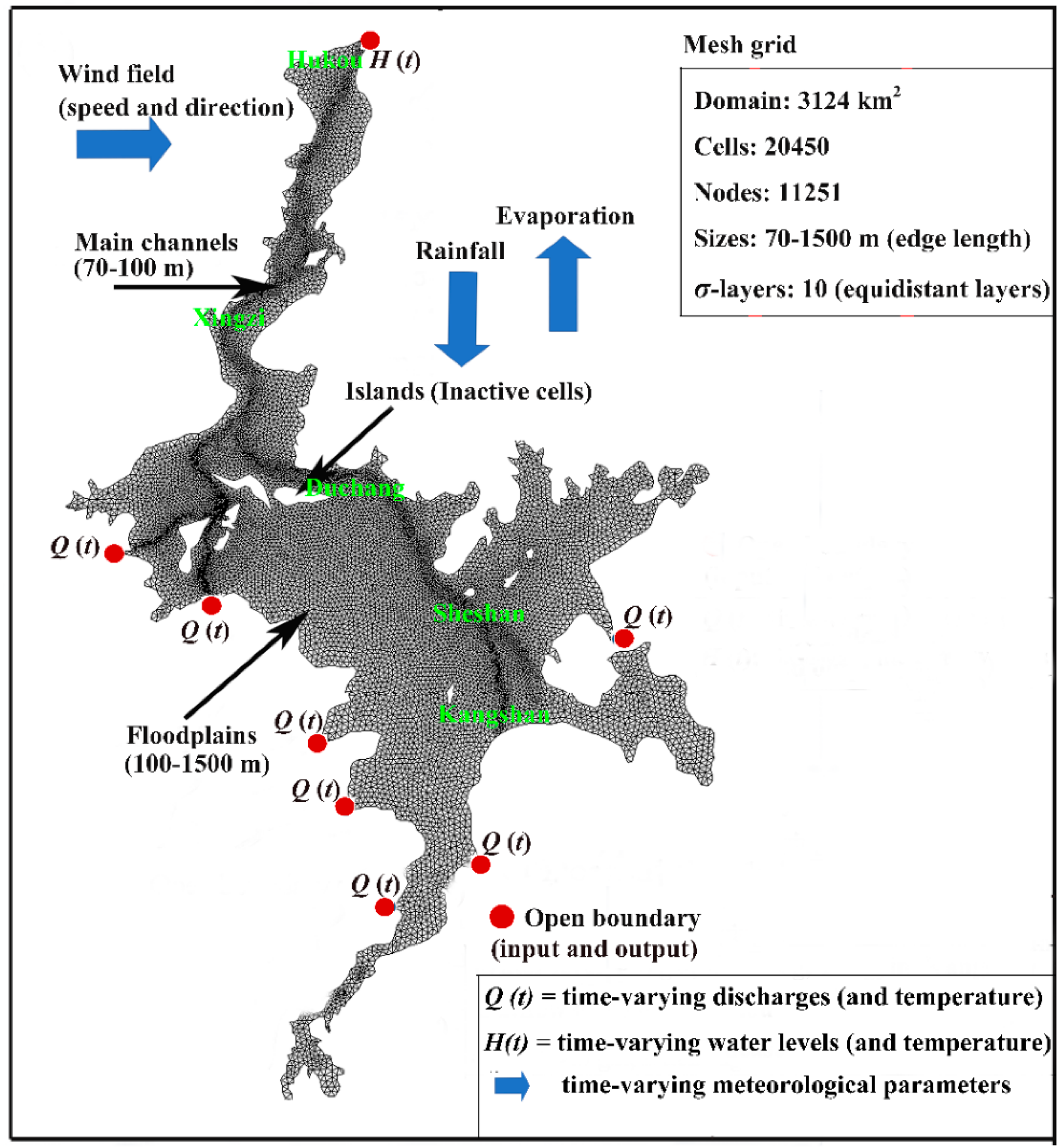
2.3. Floodplain Hydrodynamic Model

MIKE 21 is a finite-volume model developed by the Danish Hydraulic Institute (DHI) which can be used to determine the temporal and spatial changes in hydrodynamics, in response to wind, river flow inputs, and a variety of other surface water forces [50]. The model is a two-dimensional (2D) physical-based mathematical model for various kinds of surface waterbodies. The wet–dry point treatment method of MIKE 21 is suitable for simulating the wetting and drying processes associated with the considerable variations in the lake area and inundation duration [50]. MIKE 21 is a powerful and popular hydrodynamic modeling system used around the world. The hydrodynamic model MIKE 21 used in this study was recently assembled by Li et al. [45] which was successfully applied to study the hydrological regime of Poyang Lake and the associate causes and potential impacts [5,8,37,40,45,51,52,53,54]. Based on the previous work, the constructed Poyang Lake hydrodynamic model [45] was the preferred application in our study.
The MIKE 21 model was constructed on a bathymetric map (i.e., DEM) of Poyang Lake obtained in 1998 and updated in 2010 [5,45]. Li et al. [45] extended the boundary of the model to include the upstream reaches of the major catchment rivers (Figure 1b). A triangular mesh of variable cell size (70–1500 m) was used to discretize the computational domain of the lake, resulting in a total of 20,450 triangular elements. The element size was adjusted by trial and error during model construction to minimize numerical instability. In addition, the time step was set to 5 s for limiting the Courant–Friedrich–Levy (CFL) number and matching the cell size [50]. The model was calibrated and validated for the periods of 2000–2005 and 2006–2008, respectively [45]. Calibrated parameters included the hydraulic roughness values (Manning number; M) and a Smagorinsky factor (Cs) characterizing the eddy viscosity [45]. The numerical option of wetting and drying [50] was also adjusted in the model [53,54]. The observed daily series of lake water level at Xingzi, Duchang, Sheshan, and Kangshan gauging stations in the lake and the daily outflow discharge at Hukou gauging station were used to calibrated and validated the hydrodynamic model [45]. Lake water surface areas extracted from MODIS (Moderate-resolution Imaging Spectroradiometer) surface reflectance data were used to further assessed the modeling results [45]. In addition, a further comparison between depth-averaged velocity magnitudes from the acoustic doppler current profile velocity profile and model simulations was also conducted by Li et al. [51]. The Nash–Sutcliffe efficiency coefficient (Ens), coefficient of determination (R2), and relative error (Re) were used to evaluate the model performance [45]. The constructed Poyang Lake hydrodynamic model by Li et al. [45] reproduced reasonably well the hydrological regime of the lake and surrounding floodplains, based on field measurements and remote sensing data [5,37,45,52]. Previous studies demonstrated that the model is suitable for simulating the floodplain dynamics of Poyang Lake [5,8,37,45]. Other aspects of the model construction are shown in Figure 2 and described by Li et al. [45].

2.4. Model Validation

Model calibration and validation were described in detail by Li et al. [45]; therefore, only a brief description is given here. Calibrated parameters in the floodplain hydrodynamic model include the hydraulic roughness values (Manning number, M) of different land types (i.e., 30 m1/3/s, 35 m1/3/s, and 50 m1/3/s for vegetation, mud, and permanent water area, respectively) and the Smagorinsky factor (Cs) for an eddy viscosity of 0.28 [45]. The numerical option of wetting and drying was adopted in the model by using the following thresholds: hdry (0.005 m) < hflood (0.05 m) < hwet (0.1 m) [53,54]. The Ens value for the calibration periods (2000–2005) and validation periods (2006–2008) of daily water levels at lake gauging stations varied from 0.88 to 0.98, R2 ranged from 0.96 to 0.99, and the Re value was less than 5% [45]. The Ens, R2, and Re values of the daily discharges to the Yangtze River are 0.80, 0.82, and −12%, respectively [45]. In addition, by comparing the modeled lake areas with remote sensing data for both wet and dry seasons in 2004, the Re values were obtained at 3.3% and 16.8%, respectively [37,45]. Another comparison between depth-averaged velocity magnitudes from the acoustic doppler current profile velocity profile and model simulations was also conducted by Li et al. [51], which resulted in an R2 that varied from 0.79 to 0.84. Based on the hydrodynamic simulations, the results of daily lake level, daily inundation area, and inundation duration of the Poyang Lake–floodplain system can be obtained and analyzed.

2.5. Scenario Simulation

Previous studies showed that, due to the altered river–lake relationship since 2000, Poyang Lake suffered frequent drought events in recent years, whereby the lake level declined significantly with accelerated falling water during autumn [13,28,29,30,31,32,36,37,38,39,40]. Furthermore, the Yangtze River discharge has a greater impact on annual lake level variations than the lake’s catchment inflow [39]. In addition, focusing on the inter-annual alteration of the river–lake relationship, the interaction of this river–lake system is confirmed to have been altered around 2000. Therefore, two simulation scenarios were designed to evaluate the influence of the changed river–lake interaction on the hydrological regime of the Poyang Lake floodplains. Scenario 1 (S1) represents the situation that the hydrological regime of Poyang Lake changed after the alteration of the river–lake relationship during the period from 2001–2017. The annual sequence of time-variant daily catchment inflows was obtained by the daily average gauged inflows during that period. The annual sequence of the daily water level was obtained by the daily average water level in the same period, and the data were collected at the Hukou gauging station. Scenario 2 (S2) is a hypothetical situation where the daily water levels (at Hukou) were changed to the long-term average condition for 1953–2000, but the catchment inflow condition was the same as in S1. Scenario 2 is expected to represent the general condition under the river–lake relationship for 1953–2000 more closely.
The model scenarios are regarded as a reasonable representation of the altered river–lake relationship in terms of its application to exploring lake inundation dynamics under various stresses. Likewise, the model was subsequently used to explore the effects of the catchment and the Yangtze River on seasonal variations in the lake level and the hysteretic relationships in inundation dynamics of the lake [8,37]. In this study, the general idea is to show the differences between the hydrodynamic behaviors under different modeling scenarios. That is, the differences of the simulated results between S1 and S2 (S1–S2) allow for the quantitative evaluation of the effects of the changed river–lake relationship on the hydrological regime of Poyang Lake. Specific hydrological regime (here characterized by water level, inundation area, and inundation duration) changes are discussed and interpreted in detail.

3. Results and Discussion

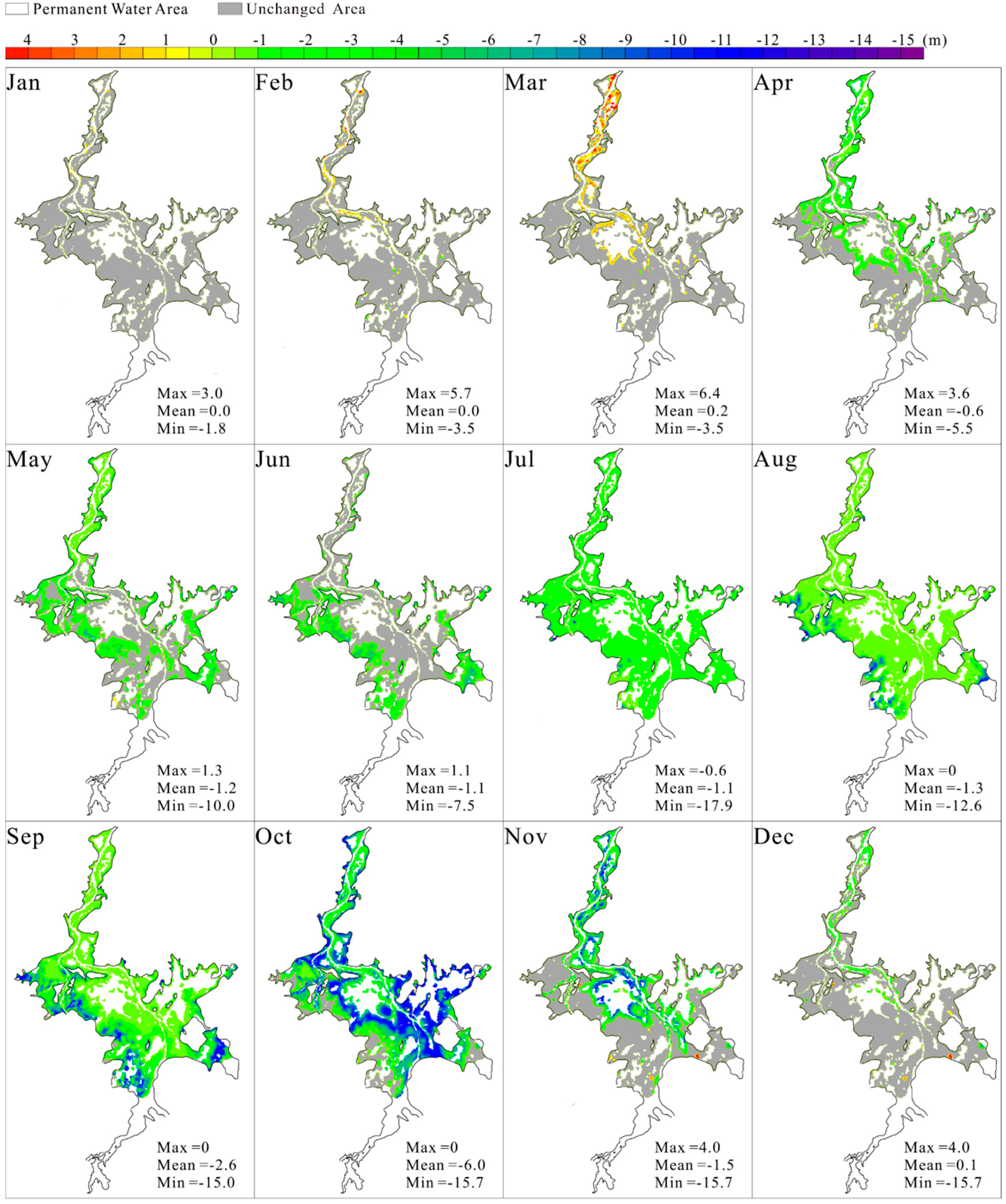
3.1. Spatiotemporal Changes in Water Level

The influenced characteristics on the water level of the Poyang lake floodplains under the changed river–lake relationship are shown in Figure 3. It is evident that the river–lake relationship alteration had little effect on raising the water level of the Poyang Lake floodplains during the dry seasons, barely increasing the water level in the floodplains near the northern channel (especially in March). From April to July, the affected area and the associated varying degree expand quickly. The mean water level decreases by ~0.6 m to over 1 m, and the affected area expands from the northern–central–eastern floodplains to the western–southern floodplains, and then to the entire Poyang Lake floodplains. Although the maximal level of the affected area in July, August, and September exhibits a similar pattern, the varying degree is gradually strengthened. We also observed that the mean water level of the whole floodplains decreases by around 2.6 m in August (mainly located in the eastern–western floodplains around the lakeshores). Moreover, by October, the affected area begins to shrink more closely to the central parts, mainly distributed on the alluvial delta regions and eastern bays. The impact reaches its peak when the mean water level of the whole floodplains decreases by 6 m in October. From November to December, the affected area further shrinks to the central–northern parts of the floodplain system. Meanwhile, the effects are weakened as the mean water level decreased by 1.5 m in November and by 0.1 m in December. Taking all of the above into consideration, the river–lake relationship alteration has much more impact on the Poyang Lake floodplains during the lake level falling period, especially on the northern–central–eastern low-slope floodplains in October.

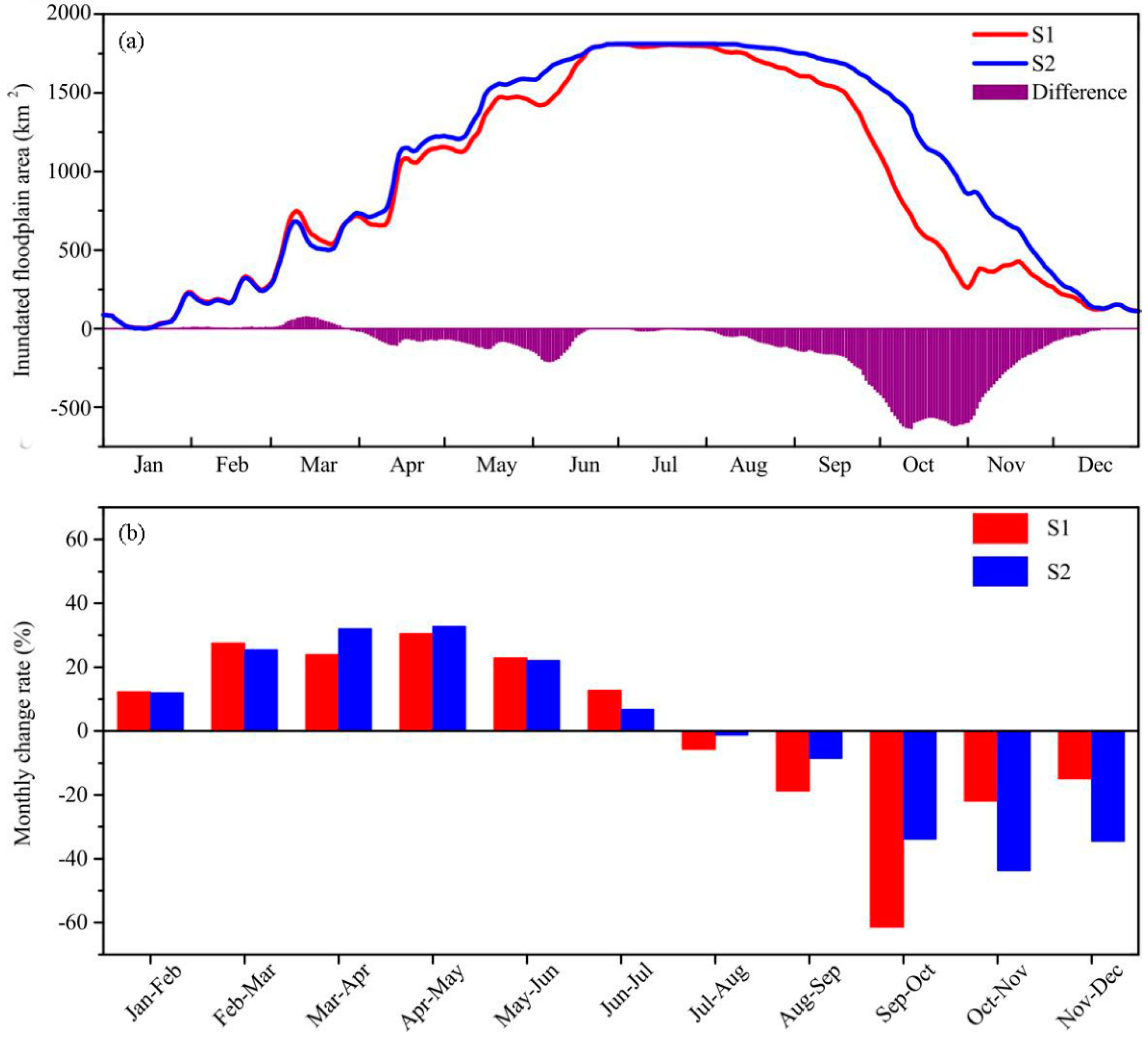
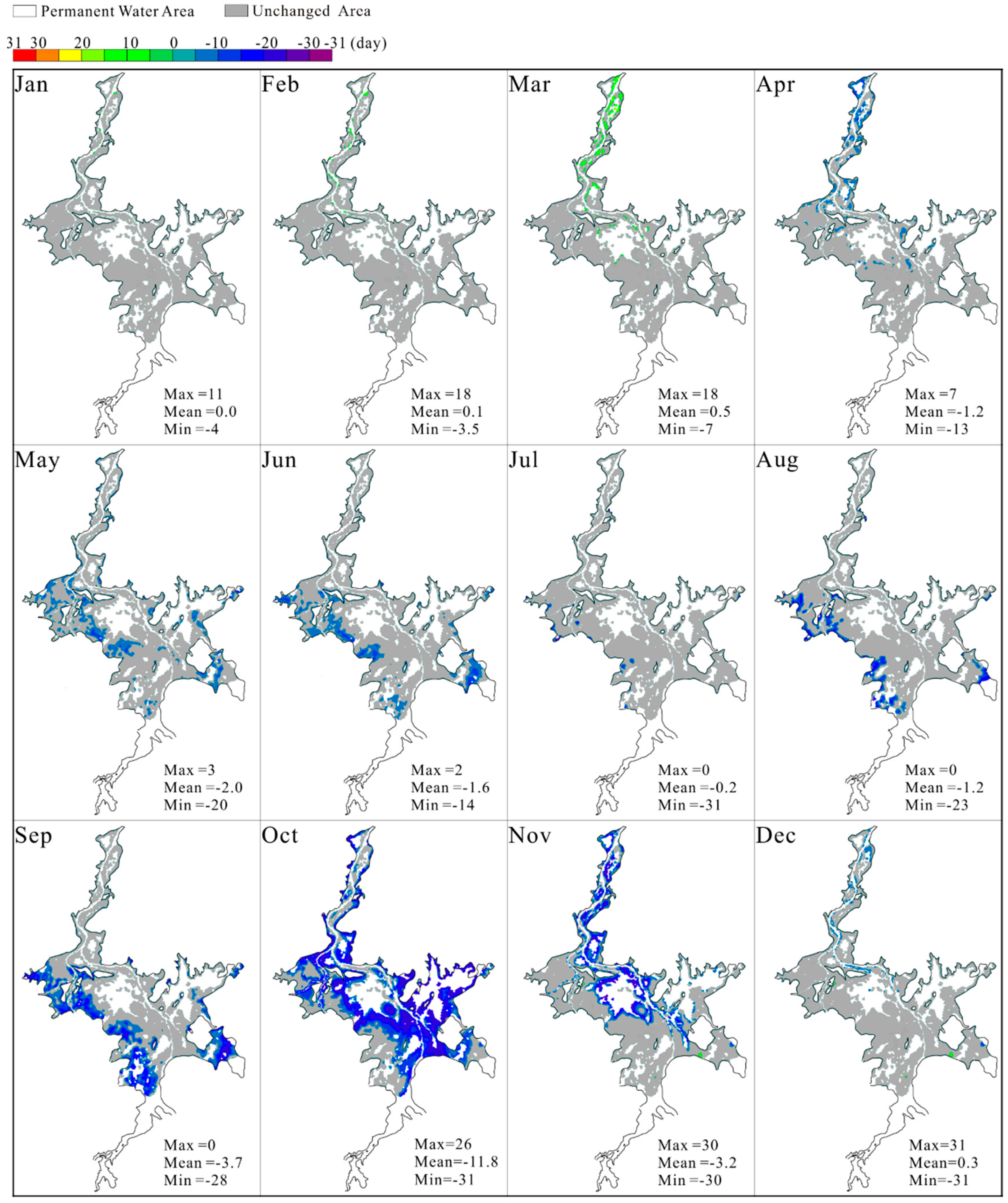
3.2. Changes in Inundation Extent

Figure 4a shows the temporal variations in the inundation area for the Poyang Lake floodplains. Generally, the inundation area shows strong seasonality by following a unimodal distribution due to the seasonal variations of the catchment inflows and water exchange with the Yangtze River [17,48]. It is also in agreement with the changing process of the floodplain inundation. From February to June, the inundated floodplain area rapidly increases, and both S1 and S2 predict a maximum inundation area (~1800 km2) at the end of June that lasts until the next month. After that, the inundated floodplain area begins to shrink rapidly and decreases to less than 200 km2 in December. Overall, the inundated floodplain area experiences very little change (−5% to 1%) during the low lake level period (i.e., January, February, and December), while it retains almost the same trend during the high lake level period (July–August). A distinct extension or shrinkage can be observed (−10% to 5%) during the lake level rising period (March–June, slightly increased in March), and a significant decreasing tendency is found (−48% to −10%) during the lake level falling period (September–November). The most striking result is that the mean inundation area of S1 decreases by up to ~600 km2 in October, accounting for nearly 50% compared to that of S2.
In order to further analyze the inundation behavior, the change rates for the monthly inundation area between S1 and S2 are shown in Figure 4b. The result indicates that the monthly change rate varies from −60% to 30%, and from −40% to 35% for S1 and S2, respectively. The valley value of the monthly change rate shifts to September–October in S1 and October−November in S2 during the shrinkage stage, which indicates a significant seasonal variation in the exposure process under the influence of the recent changes in the river-lake relationship. The results presented in Figure 4 indicate that the modified river–lake relationship exhibits a minor influence on the inundated floodplain area during the high and low lake level periods but has a large effect on the inundation area during the lake level falling period. That is, the altered river–lake interaction increases the exposure rate of the inundation area and, hence, leads to about a one-month advanced appearance of the onset time in the large parts of the floodplains, indicating a longer dry duration of the lake in the 2000s [36,39]. It is critical for Poyang Lake water resource utilization to consider the regional and spatial distribution of these floodplain inundation changes.
Figure 5 shows the monthly comparison of the changing processes for the floodplain inundation in S1 and S2. The simulation results present the spatial changes of the inundation process in the Poyang Lake floodplains in response to the changed river–lake relationship. Spatially, the inundation area extends from minimum (in red) to maximum (in blue) during the expansion period, while the inundation area shrinks from maximum (in blue) to minimum (in red) during the shrinkage period. For both S1 and S2, from January to July, the inundation area expands from small regions distributed along the main river channels outward to high-lying floodplains (i.e., fully inundated). In addition, the northern channel floodplains are inundated earlier than the catchment river alluvial deltas (i.e., near the lake shorelines), which coincides with the results reported by Wu and Liu [48], who suggested that the mean inundation frequency increases slowly from north to south during January–August. During the shrinkage period, the floodplains in the eastern–northern areas dry up first (August to September) in S1 and S2. The most significant changes in the changing process of the floodplain inundation distribution occur in October. The inundated floodplain only recedes from the catchment river alluvial deltas (eastern–southern–western parts) to the central–northern parts in October in S2, and a large area of the floodplains remains inundated. By contrast, the distribution of the maximum inundation floodplains in October in S1 is almost coincident with the distribution of the minimum inundation floodplain in S2. The inundated floodplain dramatically declines, and the floodplain water is mainly constrained in northern channels by the end of October in S1. After that, the inundated floodplains rapidly recede toward the central and northern parts, until the Poyang Lake floodplains are almost fully exposed in December. These previous results indicate that the changed river–lake relationship has a much greater influence on the floodplain inundation exposure processes. It is clear that the changes in the hydrological regime of the Poyang Lake floodplains can lead to more severe droughts and subsequently intensify the local water supply deficits with considerable socio-economic loss.

3.3. Changes in Inundation Duration

Figure 6 shows the monthly average spatial differences in the inundation duration of the Poyang Lake floodplains. We expect that the spatial–temporal changes in inundation duration are similar to those of the inundation area and the water level of the floodplains. From January to March, the inundation duration is slightly prolonged in the northern parts of the Poyang Lake floodplains. Although the mean inundation duration from January to March expands less than half a day, the maximum prolongation time of the inundation duration in the northern parts of the floodplain is around half a month. Beginning in April, the inundation duration of the northern parts starts to shorten. During May–September, the affected floodplains are primarily shifted to the deltas of the Xiushui and Ganjiang Rivers and the eastern lake bays. Notably, a significant expansion of the affected areas and a dramatic contraction of the inundation duration are observed in October. The affected area is indented from lake boundaries toward the large central parts of the flat floodplains with a maximum shortened inundation duration of one month. From November to December, the affected floodplains shrink to the northern–central parts, and the mean value declines to just over three days in November and less than half a day in December.
According to Tan et al. [13], who attempted to illustrate the connection between the Poyang Lake wetland vegetation distribution and the lake hydrological conditions, the inundation duration has more significant effects on the distribution of plant communities than the inundation depth or frequency. Our results show that the inundation duration of the Poyang Lake floodplain is significantly shortened in October, which is directly linked to the stability of the Poyang Lake wetland ecosystem structure. As pointed out by Han et al. [41] and Li et al. [52], the coverage of wetland vegetation rapidly increased during the 2000s with an accelerated expansion of plants in the mid-floodplains. The study of the changes in the inundation duration of the Poyang Lake floodplains related to the river–lake relationship alteration appears to be essential for the future management of the Poyang Lake wetlands.

3.4. Limitations and Uncertainties

For Poyang Lake, a water-carrying lake, the hydrological regime and the water balance of the lake are more complicated due to the composition of the unique lake–river system. The changing characteristics of lake variations and the potential causes are rather complex and multifactorial, which drew worldwide attention with multiple extensive studies. It is expected that the hydrodynamic fields, inundation extent, lake area and storage, and lake–floodplain interactions may be disturbed or altered throughout the whole system [53,54,55,56,57], due to climate change and human activities [54,58,59,60]. Several studies were carried out to investigate the interactions of the Yangtze River and the lake, and how modifications to the Yangtze River basin and local catchment affect the hydrological and hydrodynamic conditions of the lake [26,27,28,29,30,31,32,34,35,36,37,39]. Previous studies showed that the drainage effect of the Yangtze River was the primary causal factor for the persistent dryness of Poyang Lake [37,39]. Compared to climate variability impacts on the lake catchment, modifications to Yangtze River flow from the Three Gorges Dam had a much greater impact on the seasonal (September–October) dryness of the lake [37]. Therefore, the focus of this study was to assess the altered river–lake relationship around 2000 and its impacts on the Poyang Lake floodplain by employing a physical-based hydrodynamic model. However, the strong shift between dry and wet seasons in the Poyang Lake region is expected to accelerate the hydrological processes under future climate change [56,57]. In addition, extensive sand mining within the main lake [58,59] and sluice regulation in the seasonal lakes [60] may inevitably influence the floodplain inundation dynamics during dry period. Considering the above limitations, future studies are required to distinguish and evaluate how the changes of the lake catchment inflows caused by climate change and human activities affect the seasonal floodplain inundation processes.
The hydrodynamic model MIKE 21 was the critical tool in our study. It must be acknowledged that many influencing factors may affect the accuracy of model results, especially the hydro-geomorphologic condition for such a long period (1953–2017). The sediment transport and the associated changes in the lake’s bathymetry were not considered in this study. Poyang Lake’s floodplains are clearly characterized by complex topographical features, and the hydrological regime of the lake is largely dependent on its bathymetry [58,59]. The lake bathymetry was relatively stable during the previous 40 years [61], despite major changes in the bathymetry occurring in the main flow channels, localized in the northern part of the lake (the bed erosion of the northern outlet channel averaged 3 m) due to sand mining in recent years. Yao et al. [59] combined hydrological data and a physical-based hydrodynamic model (same as Li et al. [45]) to quantify the influence of the bathymetric changes (1998–2010) on the spatiotemporal distribution of water levels in Poyang Lake. The low lake levels (below 16 m during the rising period and below 14 m during the recession period) were more sensitive to the bathymetric changes than the high lake levels (nearly unaffected) [59]. The influence of the bathymetric changes on the spatial distributions of the water level need to be further evaluated. Another significant calibrated parameter in the model was the Manning’s roughness coefficient. Spatially varying land covers were represented by the model’s roughness parameters, whereby an increase in roughness represents denser vegetation [8,45]. Sensitivity testing showed that the roughness (the same hydrodynamic model as Li et al. [45]) of the land surface has a greater effect on the floodplain area than the permanently inundated area [8]. Further investigation is required to quantitatively evaluate the potential influences of vegetation roughness changes on the lake inundations. However, the changes of bathymetric and wetland vegetation distribution, and their associated effects on inundation behaviors are expected to be minor, relative to other external factors (e.g., the Yangtze River flow). Overall, the hydrodynamic model remains a reasonable representation of floodplain lakes for the purposes of assessing the floodplain hydrodynamic behaviors, as demonstrated by satisfactory agreement between field measurements and the hydrodynamic model’s outputs.

4. Conclusions

This work was built on previous studies that focused on the temporal variations in the Yangtze River flow pattern and the changed river–lake relationship. We expect to overcome the limitations of the current studies by providing detailed information about the inundation behavior in the data-limited environment of the Poyang Lake–floodplain system (China). The present study is the first to interrogate the influence of the changed river–lake relationship on the hydrodynamic behaviors in the large floodplain system using a 2D floodplain hydrodynamic model.
Hydrodynamic simulations revealed that the modified river–lake relationship has a significant influence on the hydrological regime of the Poyang Lake floodplains since 2000, relative to the previous river–lake relationship (1953–2000). The results indicate that the alteration of the river–lake relationship plays a vital role in breaking the seasonal floodplain inundation process during the lake level falling period, especially for the greatest impacts in October. The mean water level, floodplain inundation area, and the inundation duration decreased by around 50% (~600 km2), 6 m, and 12 days, respectively. Spatially, the affected areas and the associated varying degree in the floodplain system are observed in the low-slope floodplains and lowland regions adjacent to the main flow channels. Our findings highlight the important role of the river–lake interaction and the associated ecological effects on the floodplain wetlands of the lake, which provide useful information for the future lake/wetland management of Poyang Lake with better management of the impacts of intensive human activities. Furthermore, the outcomes from this work can play a critical role in guiding future strategies for Poyang Lake and other similar floodplain systems, given proposals to protect the valuable migratory birds and manage their floodplain vegetation, water quality, and other ecological functions.

Author Contributions

Conceptualization, data curation, and original draft preparation, M.L.; methodology, review, and editing, Y.L. All authors have read and agreed to the published version of the manuscript.

Funding

This research was funded by the Youth Innovation Promotion Association of the CAS (Y9CJH01001), the National Natural Science Foundation of China (41771037), and the Science Foundation of Nanjing Institute of Geography and Limnology, Chinese Academy of Sciences (NIGLAS2018GH06).

Conflicts of Interest

The authors declare no conflicts of interest.

References

  1. van der Most, M.; Hudson, P.F. The influence of floodplain geomorphology and hydrologic connectivity on alligator gar (Atractosteus spatula) habitat along the embanked floodplain of the Lower Mississippi River. Geomorphology 2018, 302, 62–75. [Google Scholar] [CrossRef]
  2. Entwistle, N.S.; Heritage, G.L.; Schofield, L.A.; Williamson, R.J. Recent changes to floodplain character and functionality in England. Catena 2019, 174, 490–498. [Google Scholar] [CrossRef]
  3. Melack, J.M.; Forsberg, B.R. Biogeochemistry of Amazon Floodplain Lakes and Associated Wetlands. In The Biogeochemistry of the Amazon Basin and Its Role in a Changing World; Oxford University Press: Oxford, UK, 2001; pp. 235–276. [Google Scholar]
  4. Bonnet, M.P.; Barroux, G.; Martinez, J.M.; Seyler, F.; Moreira-Turcq, P.; Cochonneau, G.; Roux, E. Floodplain hydrology in an Amazon floodplain lake (Lago Grande de Curuaí). J. Hydrol. 2008, 349, 18–30. [Google Scholar] [CrossRef] [Green Version]
  5. Li, Y.; Zhang, Q.; Cai, Y.; Tan, Z.; Wu, H.; Liu, X.; Yao, J. Hydrodynamic investigation of surface hydrological connectivity and its effects on the water quality of seasonal lakes: Insights from a complex floodplain setting (Poyang Lake, China). Sci. Total Environ. 2019, 660, 245–259. [Google Scholar] [CrossRef] [PubMed]
  6. Rolls, R.J.; Leigh, C.; Sheldon, F. Mechanistic effects of low-flow hydrology on riverine ecosystems: Ecological principles and consequences of alteration. Freshwater Sci. 2012, 31, 1163–1186. [Google Scholar] [CrossRef] [Green Version]
  7. Helton, A.M.; Poole, G.C.; Payn, R.A.; Izurieta, C.; Stanford, J.A. Relative influences of the river channel, floodplain surface, and alluvial aquifer on simulated hydrologic residence time in a montane river floodplain. Geomorphology 2014, 205, 17–26. [Google Scholar] [CrossRef]
  8. Zhang, Q.; Werner, A.D. Hysteretic relationships in inundation dynamics for a large lake–floodplain system. J. Hydrol. 2015, 527, 160–171. [Google Scholar] [CrossRef]
  9. Babbitt, K.J. The relative importance of wetland size and hydroperiod for amphibians in southern New Hampshire, USA. Wetl. Ecol. Manag. 2005, 13, 269–279. [Google Scholar] [CrossRef]
  10. Crase, B.; Liedloff, A.; Vesk, P.A.; Burgman, M.A.; Wintle, B.A. Hydroperiod is the main driver of the spatial pattern of dominance in mangrove communities. Glob. Ecol. Biogeogr. 2013, 22, 806–817. [Google Scholar] [CrossRef]
  11. Murray-Hudson, M.; Wolski, P.; Murray-Hudson, F.; Brown, M.T.; Kashe, K. Disaggregating hydroperiod: Components of the seasonal flood pulse as drivers of plant species distribution in floodplains of a tropical wetland. Wetlands 2014, 34, 927–942. [Google Scholar] [CrossRef]
  12. Murray-Hudson, M.; Wolski, P.; Cassidy, L.; Brown, M.T.; Thito, K.; Kashe, K.; Mosimanyana, E. Remote Sensing-derived hydroperiod as a predictor of floodplain vegetation composition. Wetl. Ecol. Manag. 2015, 23, 603–616. [Google Scholar] [CrossRef]
  13. Tan, Z.; Zhang, Q.; Li, M.; Li, Y.; Xu, X.; Jiang, J. A study of the relationship between wetland vegetation communities and water regimes using a combined remote sensing and hydraulic modeling approach. Hydrol. Res. 2016, 47, 278–292. [Google Scholar]
  14. Legesse, D.; Vallet-Coulomb, C.; Gasse, F. Analysis of the hydrological response of a tropical terminal lake, Lake Abiyata (Main Ethiopian Rift Valley) to changes in climate and human activities. Hydrol. Process. 2004, 18, 487–504. [Google Scholar] [CrossRef]
  15. Correa-Araneda, F.J.; Urrutia, J.; Soto-Mora, Y.; Figueroa, R.; Hauenstein, E. Effects of the hydroperiod on the vegetative and community structure of freshwater forested wetlands. Chile. J. Freshw. Ecol. 2012, 27, 459–470. [Google Scholar] [CrossRef] [Green Version]
  16. Long, C.M.; Pavelsky, T.M. Remote sensing of suspended sediment concentration and hydrologic connectivity in a complex wetland environment. Remote Sens. Environ. 2013, 129, 197–209. [Google Scholar] [CrossRef] [Green Version]
  17. Feng, L.; Hu, C.; Chen, X.; Cai, X.; Tian, L.; Gan, W. Assessment of inundation changes of Poyang Lake using MODIS observations between 2000 and 2010. Remote Sens. Environ. 2012, 121, 80–92. [Google Scholar] [CrossRef]
  18. Feng, L.; Hu, C.; Chen, X.; Zhao, X. Dramatic inundation changes of China’s two largest freshwater lakes linked to the Three Gorges Dam. Environ. Sci. Technol. 2013, 47, 9628–9634. [Google Scholar] [CrossRef]
  19. Gilvear, D.; Bryant, R. Analysis of remotely sensed data for fluvial geomorphology and river science. In Tools in Fluvial Geomorphology; John Wiley & Sons: Hoboken, NJ, USA, 2016; pp. 103–132. [Google Scholar]
  20. Malinowski, R.; Höfle, B.; Koenig, K.; Groom, G.; Schwanghart, W.; Heckrath, G. Local-scale flood mapping on vegetated floodplains from radiometrically calibrated airborne LiDAR data. ISPRS J. Photogramm. 2016, 119, 267–279. [Google Scholar] [CrossRef]
  21. Cui, L.; Wu, G.; Liu, Y. Monitoring the impact of backflow and dredging on water clarity using MODIS images of Poyang lake, china. Hydrol. Process. 2009, 23, 342–350. [Google Scholar] [CrossRef]
  22. Townsend, P.A. Relationships between vegetation patterns and hydroperiod on the Roanoke River floodplain, North Carolina. Plant Ecol. 2001, 156, 43–58. [Google Scholar] [CrossRef]
  23. Zerger, A.; Wealands, S. Beyond modelling: Linking models with GIS for flood risk management. Nat. Hazards 2004, 33, 191–208. [Google Scholar] [CrossRef]
  24. May, C.L.; Koseff, J.R.; Lucas, L.V.; Cloern, J.E.; Schoellhamer, D.H. Effects of spatial and temporal variability of turbidity on phytoplankton blooms. Mar. Ecol. Prog. Ser. 2003, 254, 111–128. [Google Scholar] [CrossRef] [Green Version]
  25. Chatterjee, C.; Foerster, S.; Bronstert, A. Comparison of hydrodynamic models of different complexities to model floods with emergency storage areas. Hydrol. Process. 2008, 22, 4695–4709. [Google Scholar] [CrossRef]
  26. Hu, Q.; Feng, S.; Guo, H. Interactions of the Yangtze river flow and hydrologic processes of the Poyang Lake, China. J. Hydrol. 2007, 347, 90–100. [Google Scholar] [CrossRef]
  27. Guo, H.; Hu, Q.; Zhang, Q. Changes in hydrological interactions of the Yangtze River and the Poyang Lake in China during 1957–2008. Acta Geogr. 2011, 66, 609–618. (In Chinese) [Google Scholar]
  28. Guo, H.; Hu, Q.; Zhang, Q.; Feng, S. Effects of the three gorges dam on Yangtze River flow and river interaction with Poyang lake, china: 2003–2008. J. Hydrol. 2012, 416, 19–27. [Google Scholar] [CrossRef]
  29. Zhang, Q.; Li, L.; Wang, Y.G.; Werner, A.D.; Xin, P.; Jiang, T.; Barry, D.A. Has the Three-Gorges Dam made the Poyang Lake wetlands wetter and drier? Geophys. Res. Lett. 2012, 39. [Google Scholar] [CrossRef] [Green Version]
  30. Jiang, L.; Ban, X.; Wang, X.; Cai, X. Assessment of hydrologic alterations caused by the Three Gorges Dam in the Middle and Lower Reaches of Yangtze River, China. Water 2014, 6, 1419–1434. [Google Scholar] [CrossRef] [Green Version]
  31. Zhang, Z.; Chen, X.; Xu, C.Y.; Hong, Y.; Hardy, J.; Sun, Z. Examining the influence of river–lake interaction on the drought and water resources in the Poyang Lake basin. J. Hydrol. 2015, 522, 510–521. [Google Scholar] [CrossRef]
  32. Wang, Y.; Rhoads, B.L.; Wang, D. Assessment of the flow regime alterations in the middle reach of the Yangtze River associated with dam construction: Potential ecological implications. Hydrol. Process. 2016, 30, 3949–3966. [Google Scholar] [CrossRef]
  33. Zhang, D.; Hong, H.; Zhang, Q.; Li, X. Attribution of the changes in annual streamflow in the Yangtze River Basin over the past 146 years. Theor. Appl. Climatol. 2015, 119, 323–332. [Google Scholar] [CrossRef]
  34. Lai, X.; Liang, Q.; Jiang, J.; Huang, Q. Impoundment effects of the Three-Gorges-Dam on flow regimes in two China’s largest freshwater lakes. Water Resour. Manag. 2014, 28, 5111–5124. [Google Scholar] [CrossRef]
  35. Lai, X.; Liang, Q.; Huang, Q.; Jiang, J.; Lu, X.X. Numerical evaluation of flow regime changes induced by the Three Gorges Dam in the Middle Yangtze. Hydrol. Res. 2016, 47, 149–160. [Google Scholar] [CrossRef] [Green Version]
  36. Min, Q.; Zhan, L. Characteristics of low-water level changes in lake Poyang during 1952–2011. J. Lake Sci. 2012, 24, 675–678. (In Chinese) [Google Scholar]
  37. Zhang, Q.; Ye, X.; Werner, A.D.; Li, Y.L.; Yao, J.; Li, X. An investigation of enhanced recessions in Poyang lake: Comparison of Yangtze river and local catchment impacts. J. Hydrol. 2014, 517, 425–434. [Google Scholar] [CrossRef] [Green Version]
  38. Dai, X.; Wan, R.; Yang, G.; Wang, X. Temporal variation of hydrological rhythm in Poyang Lake and the associated water exchange with the Changjiang River. Sci. Geogr. 2014, 12, 1488–1496. (In Chinese) [Google Scholar]
  39. Ye, X.; Li, Y.; Li, X.; Zhang, Q. Factors influencing water level changes in china’s largest freshwater lake, Poyang lake, in the past 50 years. Water Int. 2014, 39, 983–999. [Google Scholar] [CrossRef]
  40. Yao, J.; Zhang, Q.; Li, Y.; Li, M. Hydrological evidence and causes of seasonal low water levels in a large river-lake system: Poyang Lake, China. Hydrol. Res. 2016, 47, 24–39. [Google Scholar] [CrossRef] [Green Version]
  41. Han, X.; Chen, X.; Feng, L. Four decades of winter wetland changes in Poyang Lake based on Landsat observations between 1973 and 2013. Remote Sens. Environ. 2015, 156, 426–437. [Google Scholar] [CrossRef]
  42. Hu, Y.; Huang, J.; Du, Y.; Han, P.; Wang, J.; Huang, W. Monitoring wetland vegetation pattern response to water-level change resulting from the Three Gorges Project in the two largest freshwater lakes of China. Ecol. Eng. 2015, 74, 274–285. [Google Scholar] [CrossRef]
  43. Dai, X.; Wan, R.; Yang, G.; Wang, X.; Xu, L. Responses of wetland vegetation in Poyang Lake, China to water-level fluctuations. Hydrobiologia 2016, 773, 35–47. [Google Scholar] [CrossRef]
  44. Li, J. Scientists line up against dam that would alter protected wetlands. Science 2009, 326, 508–509. [Google Scholar]
  45. Li, Y.; Zhang, Q.; Yao, J.; Werner, A.D.; Li, X. Hydrodynamic and hydrological modeling of the Poyang Lake catchment system in China. J. Hydrol. Eng. 2014, 19, 607–616. [Google Scholar] [CrossRef]
  46. Ye, X.; Zhang, Q.; Liu, J.; Li, X.; Xu, C.Y. Distinguishing the relative impacts of climate change and human activities on variation of streamflow in the Poyang Lake catchment, China. J. Hydrol. 2013, 494, 83–95. [Google Scholar] [CrossRef]
  47. Wu, G.; Liu, Y. Satellite-based detection of water surface variation in China’s largest freshwater lake in response to hydro-climatic drought. Int. J. Remote Sens. 2014, 35, 4544–4558. [Google Scholar] [CrossRef]
  48. Wu, G.; Liu, Y. Capturing variations in inundation with satellite remote sensing in a morphologically complex, large lake. J. Hydrol. 2015, 523, 14–23. [Google Scholar] [CrossRef]
  49. Wu, Y.; Ji, W. Study on Jiangxi Poyang Lake National Nature Reserve; Forest Publishing House: Beijing, China, 2002. [Google Scholar]
  50. Danish Hydraulic Institute (DHI). Mike 21 Flow Model: Hydrodynamic Module User Guide; DHI: Hørsholm, Denmark, 2014. [Google Scholar]
  51. Li, Y.; Zhang, Q.; Yao, J. Investigation of residence and travel times in a large floodplain lake with complex lake-river interactions: Poyang Lake (China). Water 2015, 7, 1991–2012. [Google Scholar] [CrossRef] [Green Version]
  52. Li, M.; Zhang, Q.; Li, Y.; Yao, J.; Tan, Z. Inter-annual variations of Poyang Lake area during dry seasons: Characteristics and implications. Hydrol. Res. 2016, 47, 40–50. [Google Scholar] [CrossRef] [Green Version]
  53. Li, Y.; Zhang, Q.; Werner, A.D.; Yao, J.; Ye, X. The influence of river-to-lake backflow on the hydrodynamics of a large floodplain lake system (Poyang Lake, China). Hydrol. Process. 2017, 31, 117–132. [Google Scholar] [CrossRef]
  54. Ye, X.; Zhang, Q.; Bai, L.; Hu, Q. A modeling study of catchment discharge to Poyang Lake under future climate in China. Quat. Int. 2011, 244, 221–229. [Google Scholar] [CrossRef]
  55. Li, Y.; Zhang, Q.; Zhang, L.; Tan, Z.; Yao, J. Investigation of water temperature variations and sensitivities in a large floodplain lake system (Poyang Lake, China) using a hydrodynamic model. Remote Sens. 2017, 9, 1231. [Google Scholar] [CrossRef] [Green Version]
  56. Li, Y.; Tao, H.; Yao, J.; Zhang, Q. Application of a distributed catchment model to investigate hydrological impacts of climate change within Poyang Lake catchment (China). Hydrol. Res. 2016, 47, 120–135. [Google Scholar] [CrossRef]
  57. Li, Y.; Yao, J.; Zhao, G.; Zhang, Q. Evidences of hydraulic relationships between groundwater and lake water across the large floodplain wetland of Poyang Lake, China. Water Sci. Technol. Water Supply 2018, 18, 698–712. [Google Scholar] [CrossRef]
  58. Lai, X.; Jiang, J.; Liang, Q.; Huang, Q. Large-scale hydrodynamic modeling of the middle Yangtze River Basin with complex river-lake interactions. J. Hydrol. 2013, 492, 228–243. [Google Scholar] [CrossRef]
  59. Yao, J.; Zhang, Q.; Ye, X.; Zhang, D.; Bai, P. Quantifying the impact of bathymetric changes on the hydrological regimes in a large floodplain lake: Poyang Lake. J. Hydrol. 2018, 561, 711–723. [Google Scholar] [CrossRef]
  60. Wu, G.; Liu, Y. Seasonal water exchanges between China’s Poyang Lake and its saucer-shaped depressions on river deltas. Water 2017, 9, 884. [Google Scholar]
  61. Lai, X.; Shankman, D.; Huber, C.; Yesou, H.; Huang, Q.; Jiang, J. Sand mining and increasing Poyang Lake’s discharge ability: A reassessment of causes for lake decline in China. J. Hydrol. 2014, 519, 1698–1706. [Google Scholar] [CrossRef]
Figure 1. (a) Location of Poyang Lake in China and the river–lake system in the middle Yangtze River basin; (b) Poyang Lake, its floodplain wetlands, and major inflow rivers. PLNNR: Poyang Lake National Nature Reserve; NWNNR: Nanji Wetland National Nature Reserve.
Water 12 00626 g001
Figure 2. Domain, mesh grid, and major inputs/outputs for the MIKE 21 floodplain model of Poyang Lake, according to Li et al. [45].
Water 12 00626 g002
Figure 3. Spatial differences and varying degree of monthly average lake levels in the Poyang Lake floodplains between S1 and S2 (S1–S2). The gray area indicates the unaffected floodplains.
Water 12 00626 g003
Figure 4. (a) Variations in the inundation area of the Poyang Lake floodplains for S1 and S2. The differences of the inundation area between S1 and S2 are also presented. (b) Comparison of the change rates for the monthly inundation area between S1 and S2 (S1–S2). Positive values in (b) indicate expansion of the inundated floodplains, and negative values indicate shrinkage of the inundated floodplains.
Water 12 00626 g004
Figure 5. Monthly comparison of maximum and minimum inundation distribution in the Poyang Lake floodplains for S1 and S2. The gray area indicates the boundaries of the Poyang Lake floodplains, and the white area indicates the permanent water regions.
Water 12 00626 g005
Figure 6. Spatial differences and varying degree of average inundated days in the Poyang Lake floodplains between S1 and S2 (S1–S2). The gray area means the unaffected floodplains.
Water 12 00626 g006

