Article

Spatiotemporal Distribution and Species Composition of Fish Assemblages in the Transitional Zone of the Three Gorges Reservoir, China

1
Institute of Hydrobiology, Chinese Academy of Sciences, Wuhan 430072, China
2
Hubei Key Laboratory of Three Gorges Project for Conservation of Fishes, Chinese Sturgeon Research Institute, China Three Gorges Corporation, Yichang 443000, China
3
Department of Maritime Police and Production System, Institute of Marine Industry, Gyeongsang National University, Tongyeong 650-912, Korea
*
Authors to whom correspondence should be addressed.
Water 2020, 12(12), 3514; https://doi.org/10.3390/w12123514
Submission received: 27 October 2020 / Revised: 27 November 2020 / Accepted: 10 December 2020 / Published: 14 December 2020
(This article belongs to the Special Issue Hydroacoustics in Marine, Transitional and Freshwaters)

Abstract

:
The river–reservoir transitional zones play an important role in maintaining riverine fish biodiversity and abundance in highly regulated rivers. The Upper Yangtze River, which contains 286 fish species, is experiencing intense hydropower development. However, few studies have been conducted on the spatial distribution of fish in the river–reservoir transitional zones in the Upper Yangtze River, and it is therefore difficult to predict how this development will impact the region. In this study, a 200-kHz split-beam acoustic system in combination with biological samplings was used to investigate the composition and spatiotemporal distribution of the fish in the transition zone of the Three Gorges Reservoir (TGR) in 2017. The biological samplings comprised 7434 individuals from 61 species, 38 genera, 15 families, and 5 orders. The dominant fish species were Rhinogobio cylindricus, Coreius guichenoti, Hemiculter bleekeri, and Pelteobagrus vachelli. Acoustic detection identified the mean target strength (TS) to be −55.6 in May, −57.8 in August, and −55.8 dB in December. Accordingly, the average fish density was 4.96, 6.96, and 4.42 ind/1000 m3. Significant differences were found in the TS and fish density between flood season (August) and non-flood season (May and December). Spatially, fish preferred the meandering sections at 10–20 m deep. A size-dependent vertical distribution pattern was observed, with larger fish in the deeper layers and smaller fish in shallower waters. Lastly, our results suggest that meandering deep channels should be assigned high priority with respect to fish conservation in the Upper Yangtze River.

1. Introduction

Understanding the spatial distribution of fish is a major theme in freshwater ecology. It not only enhances our understanding of the relationship between fish species and relevant environments, but also allows scientists to identify critical habitats, and collect essential information to formulate effective freshwater fishery management and conservation strategies [1]. Past studies of freshwater fish in streams and rivers have led to a generalized understanding that freshwater fish assemblages are structured in part by local channel structure and hydraulic conditions in temperate regions [2,3,4]. The structural heterogeneity of a river channel, determined by the presence of bends and pools, may attract fish [3]. Water temperature, a fundamental property of fish habitats, affects stream metabolism, and fish bioenergetics, and can thus structure fish communities. Anthropogenic activities, such as the construction of huge dams and changes in land use, can also alter channel morphology and affect the temporal distribution of thermally-suitable habitats [4]. In highly regulated rivers, dams and reservoirs alter the riverine environment through inundation, hydrologic alteration, and fragmentation, which may shift fish distributions and modify fish assemblages [5]. Previous studies have reported that lake and river fish can coexist in the transitional zone where the hydrological regime frequently switches due to operations related to reservoirs [6,7]. However, most studies have focused on the fish distribution at the reservoir or larger watershed scales, whereas little attention has been paid to the reach or local scales [8].
Several monitoring techniques can be used to display the spatial distribution of fish, such as net catching, electrofishing, hydroacoustics, and underwater video [9]. Of these, the hydroacoustic method is a repeatable and noninvasive approach to studying fish size, abundance, and spatial distribution in waters [9,10,11]. The rapid development and wide application of geostatistics have allowed hydroacoustics coupled with Geographic Information Systems (GIS) to create a high-resolution map of the spatial distribution of fish [8,11]. However, hydroacoustic techniques have limitations—e.g., they cannot identify species. To accurately evaluate the abundance and spatiotemporal distribution of fish, a combination of hydroacoustic methods and net sampling should be employed.
Geographically, hydroacoustic research in freshwater ecosystems is mainly concentrated in North America and Europe [11]. Although the Upper Yangtze River is a global biodiversity hotspot that harbors 286 fish species [12], few studies have applied hydroacoustic methods there [13,14,15,16]. Fish biodiversity and resources in the Upper Yangtze River have sharply declined in recent years, mainly due to widespread hydropower development in the basin [17,18,19]. The Three Gorges Reservoir (TGR) behind the Three Gorges Dam (TGD) is one of the largest reservoirs in the world. Results from model analysis and empirical monitoring showed that TGR has a significant impact on the distribution and abundance of riverine fish [5,17]. Fish diversity declined and the fish species endemic to the Upper Yangtze River—e.g., Acipenser dabryanus, Leptobotia elongata, Ancherythroculter wangi, Megalobrama elongata, Onychostoma brevis, and Ctenogobius szechuanensis—nearly disappeared in the lacustrine zone of the TGR, which runs 524 km in length upstream from the TGD. On the contrary, fish richness in the transitional zone of TGR has significantly increased by 24.2% after impoundment [20], which indicated that this area played an important role in maintaining fish resources in the Upper Yangtze River.
In this study, a combination of the hydroacoustic method with biological sampling was used to investigate fish in the transitional zone of the TGR in 2017. We aimed to (i) investigate the species composition and quantify fish density, (ii) assess the distribution of fish in the longitudinal and vertical dimensions, and (iii) identify which elements—e.g., channel morphology, water depth, and water temperature—impacted the fish distribution in the transitional zone. Our results will present spatiotemporal distribution patterns of fish assemblages in the regulated river and provide suggestions for reservoir management and conservation strategies.

2. Materials and Methods
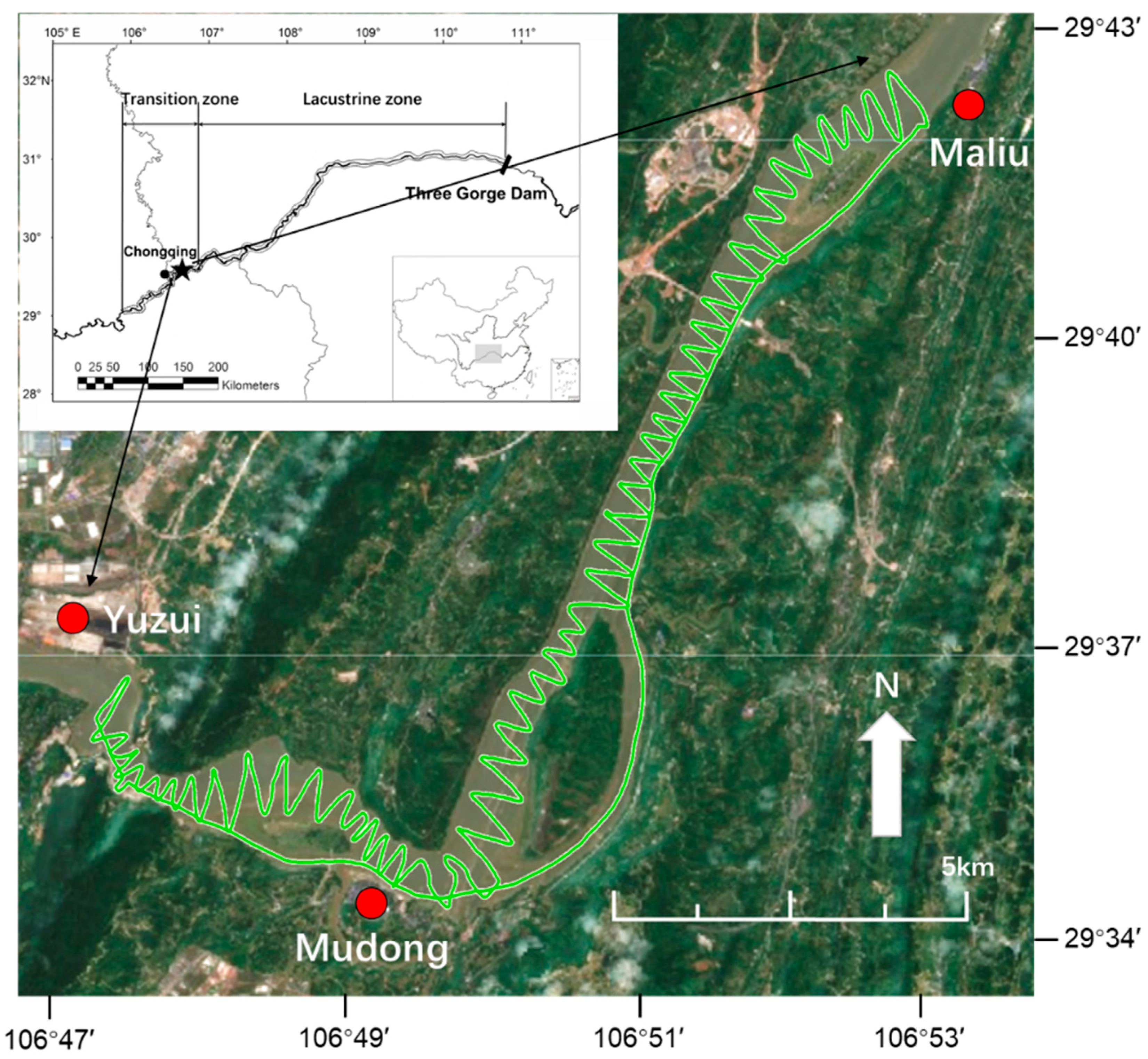
2.1. Study Area

The transitional zone of the TGR is 140 km long and comprises the reach of the Upper Yangtze River from Changshou to Jiangjin District, Chongqing City. The study area covered the Mudong reach (Yuzui to Maliu), which is 20 km long and 350–1200 m wide and is located downstream of Chongqing City (Figure 1). In the study area, two sections were categorized based on channel morphology: An upstream meandering section from Yuzui to Mudong (tortuosity coefficient of 1.35) and a downstream straight section from Mudong to Maliu (tortuosity coefficient of 1.04). Historically, the Mudong reach has ecological functions that are important for the Upper Yangtze fisheries; in particular, it serves as a spawning ground for four major species of Chinese carp and a nursery area for a number of native species [7,21,22]. Since 2008, the Mudong reach has been inundated during the dry period (October to April) due to a 175-m above sea level (ASL) experimental impoundment from the Three Gorges Dam (TGD), and has maintained a natural flowing regime during the flooding season (May to September). In 2017, the TGR began to impound with an initial water level of 153.50 m ASL on 10 September and reached the normal impoundment water level of 175 m ASL on October 21.

2.2. Environmental Data Collection

The data on water levels and daily discharges were obtained from the Cuntan hydrologic station [23]. The HOBO Water Temp Pro v2 logger (model U22-001; Onset Computer Corporation, Bourne, MA, USA) was deployed at a dock near Mudong Town and measured the water temperature at a depth of 1 m. The logger automatically collected data at 4-h intervals for all of 2017. Water depths were obtained based on acoustic data and we used interpolation to convert the depth point data into a raster data layer in ArcGIS (ver. 9.3, Esri, Redlands, CA, USA).

2.3. Hydroacoustics Surveys

Three mobile hydroacoustic surveys were conducted in 22–23 May, 30–31 August, and 9–10 December 2017 (Table 1). Each survey was performed during the day (9:00 to 18:00) because water traffic makes it dangerous to survey at night. The hydroacoustic system was a Simrad EY60 echosounder with a split-beam transducer (Simrad ES200-7C, Kongsberg Maritime, Kongsberg, Norway) with vertical pointing beam. The transducer was set to 200 kHz with a nominal beam angle of 7°. The transducer was vertically mounted to the right side of a 13-m-long fishing boat and positioned at a depth of 50 cm. The echosounder was controlled by Simrad ER 60 acquisition software (version 2.4.0), which provided a real-time display and stored acoustic raw data. Simultaneously, the geographical coordinates were recorded by a GPS (Garmin 72H) connected to the processor. The GPS was accurate to 3 m. The survey was performed on zigzag transect lines at a vessel speed of 8–10 km/h. Before the field survey, the acoustic system was calibrated with a standard 23 mm copper sphere according to the standard procedure [24]. The echosounder was set to: Power = 180 W, ping rate = 5 ping/s, and pulse duration = 128 μs. The coverage coefficient—i.e., the total length of the transect lines divided by the square root of the area—was calculated for each survey to determine whether the survey lines were enough to cover the study area [25]. The total length of the transect lines ranged from 70 to 94 km and the coverage coefficient was >14, meaning that it met the coefficient of variation for estimating fish density or fish abundance [26,27].

2.4. Biological Samplings

Biological sampling was conducted in spring (13–29 May) and autumn (26 September–9 October) of 2017 (Table 2). Biological sampling could not be implemented in August during the flood season. After the impoundment of TGR in September, fish composition and assemblage structures were similar between October and December based on the monthly investigations by Yang et al. [28]. The biological sampling conducted in October was considered to be close to the acoustic data in terms of time. Gillnets (mesh sizes of 4, 6, and 8 cm) and a trawl net (net mouth of 10-m wide and 2-m high) were used. Drift gillnets and the trawl net were used during the day (6:00–18:00) and fixed gillnets were used to sample nearshore fish in shallow waters at night (18:00–6:00). Biological sampling was performed by local experienced fishermen in different types of habitats such as pools, riffles, backwaters, and runs. Fish species were identified and the ecological groups (rheophilic, eurytopic, and limnophilic) were classified based on previous studies [17,20,29]. Then, the total length (TL, mm) and body mass (W, g) of sampled fish were measured. At least 30 individuals of each species were measured. If the number of fish caught was less than 30, then all the individuals were measured.

2.5. Acoustic Data Analysis

The acoustic raw data were converted and analyzed using the Sonar 5‒Pro software (version 5.9) [30]. A minimum display threshold on amplitude echogram was set to −70 dB—which is commonly used for unknown fish species in various waters worldwide—and a time-varied-gain (TVG) of 40 log(R) was used for target strength (TS) values [31]. An exclusion zone of 0.5 m above the river bottom was used to avoid false echoes from the bottom. Furthermore, data from the surface to 2-m deep were filtered through a straight line due to the movement of vessels and the existence of a “near-field.” Various noises were removed using the noise erasing tool in the software, and then manually scrutinized. First of all, single echoes were detected using a single echo detection (SED) algorithm with the minimum TS threshold of −70 dB, received echo length (0.5 to 1.8 times of transmitted pulse length) and the maximum beam compensation of 3 dB which was very close to the beam axis. In particular, the minimum TS threshold was set because we tried to obtain even small sized fish. Then, tracked fish were determined by the following criteria: No. echoes ≥ 4, max ping gap = 2 pings, and gating range = 0.3 m. To confirm fish tracks, each track was visually examined to ensure that tracks contained a series of contiguous single echoes in the same direction of movement in a horizontal plane of the beam [32]. All fish tracks containing mean TS and mean depth were exported for further analysis.
Since a TS‒fish length relationship for the Upper Yangtze River fish species was not available, TS (dB re 1 m−2) was calculated using an empirical formula for carps in dorsal aspect [33]:
TS = 23.97log10 TL − 103.9
where TL is the total length of an individual fish (mm). In fact, the formula was quantified at 120 kHz. For targeting carp species, a TS‒fish length equation at 200 kHz was not available, although its horizontal ex situ TS was measured [34]. For capelin, pollock, Pacific Ocean perch, and jellyfish, their frequency response patterns were similar, between 120 and 200 kHz [35]. On the basis of the general schematic description of the relative frequency response based on acoustic categories at frequencies 18–200 kHz, swimbladder-bearing fish such as carps are characterized by constancy between low frequencies (the Rayleigh scattering region) and high frequencies (the geometric scattering region) [36,37]. Thus, the sound scattering strength between 120 and 200 kHz for the species might be similar, which allowed us to use Equation (1).
Fish density (ρv) was calculated based on the following formula [30]:
ρ v = S v σ ¯ b s
where Sv is the volume backscattering coefficient (dB re 1 m2/m3), and σ ¯ b s is the mean backscattering cross-section (m2) that is the linear domain of TS.
The spatial distribution of fish density was mapped using kriging interpolation in ArcGIS (ver. 9.3, Esri). The study area (20 km from Yuzui to Maliu, moving downstream) was divided into 10 sections of 2 km each to further analyze the longitudinal distribution pattern of fish density.

2.6. Statistical Analyses

A chi-square test was applied to investigate the difference in weights of fish ecological groups between May and October. Fish length (both measured and converted lengths), density, and target depth were examined for the assumption of normality using the Kolmogorov–Smirnov test. Since the data were abnormally distributed, the differences in the size distribution from net catches between May and October were investigated using a nonparametric Kruskal–Wallis H test. In addition, the fish length and density converted from acoustic data and target depth were examined using a Kruskal–Wallis H test followed by post hoc multiple comparisons to determine which months had significantly different results. Regression analysis was used to understand the relationship between TS and target depth. Statistical analyses were performed using SPSS (version 22.0, IBM) and a p < 0.05 was considered significant. Graphs were plotted using ArcGIS and Origin (2018, OriginLab, Northampton, MA, USA).

3. Results

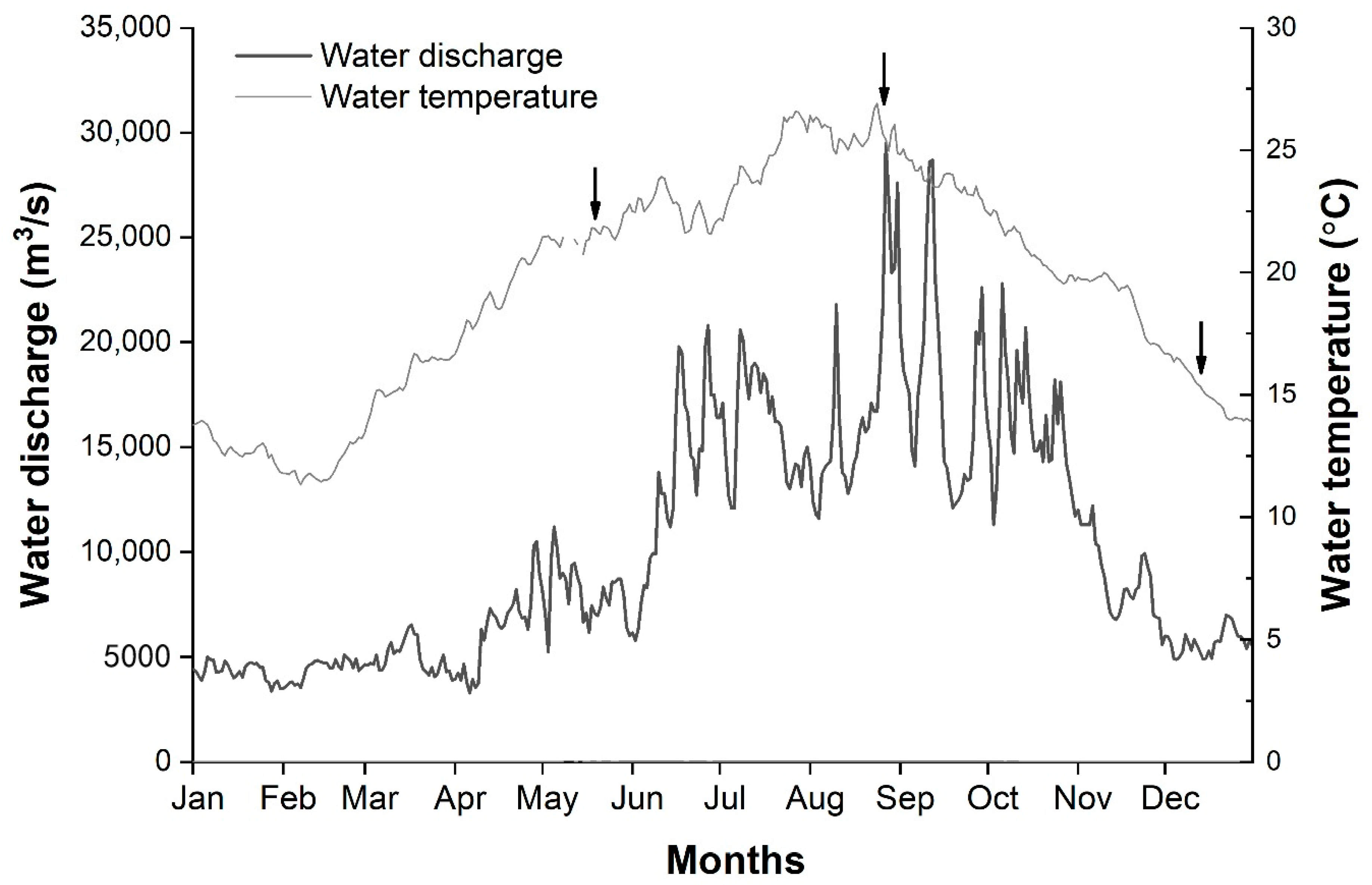
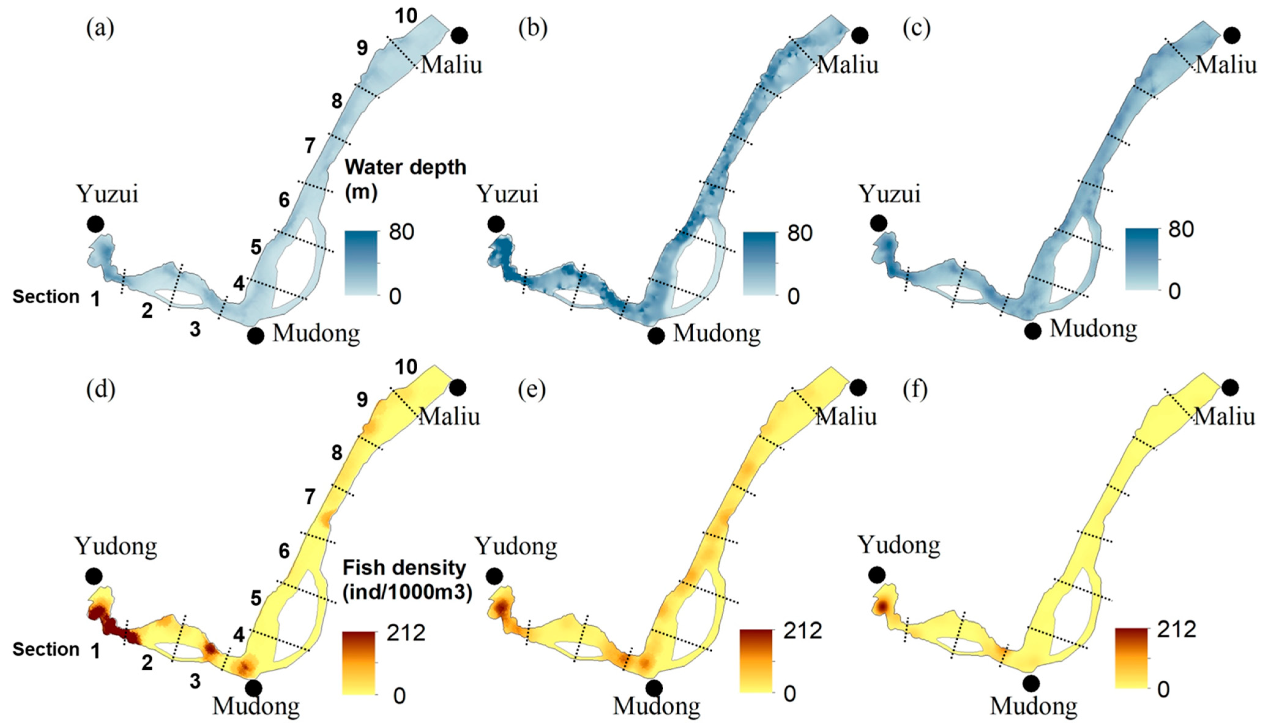
3.1. Environmental Factors

The average monthly discharge in the Mudong reach in 2017 was lowest in January (4304 m3/s) and highest in August (17,897 m3/s). Discharge during the flooding period (May–September) was 5250–29,500 m3/s, peaking on 27 August, while discharge during the non-flood period (October–April) was 3290–22,800 m3/s, peaking on 1 February (Figure 2). During the periods of hydroacoustic surveys, the average water temperature increased gradually from 21.6 in May to 25.7 °C in August, and then sharply declined to 15.1 °C in December. The average water depth was 13.1 in May, 20.4 in August, and 23.9 m in December. The average water depth was highest in December because of the impoundment from the TGR (Table 1).

3.2. Species Composition and Assemblage Structure

The total mass in May and October was 392.3 kg (Table 2). A total of 7434 individuals were identified, belonging to 61 species from 38 genera, 15 families, and five orders (Table 2). Cyprinidae of the fish species was the most common group of fish (49.2%) followed by Cobitidae (14.8%) and Bagridae (13.1%). Thirteen fish species endemic to the Upper Yangtze River and four exotic species were collected (Table 3). The dominant species was Rhinogobio cylindricus, accounting for 43.5% (W%) in May and 43.6% in October. Seven species—R. cylindricus, Coreius heterodon, Hemiculter bleekeri, Leiocassis crassilabris, Squalidus argentatus, H. leucisculus, and L. longirostris—accounted for 86.1% of the total mass in May. Nine species—R. cylindricus, Cyprinus carpio, C. heterodon, Silurus asotus, Hypophthalmichthys molitrix, S. meridionalis, R. typus, Carassius auratus, and Pelteobagrus vachelli—contributed 86.6% of the total mass in October (Table 3).
A chi-square test revealed that the relative biomasses of fish groups were significantly different between May and October (χ2 = 1304.4, p < 0.05). In May, rheophilic fish accounted for 67.7% of the total biomass and limnophilic fish accounted for 20.8%; however, the rheophilic species declined to 63.0% and the limnophilic species increased to 25.7% in October.

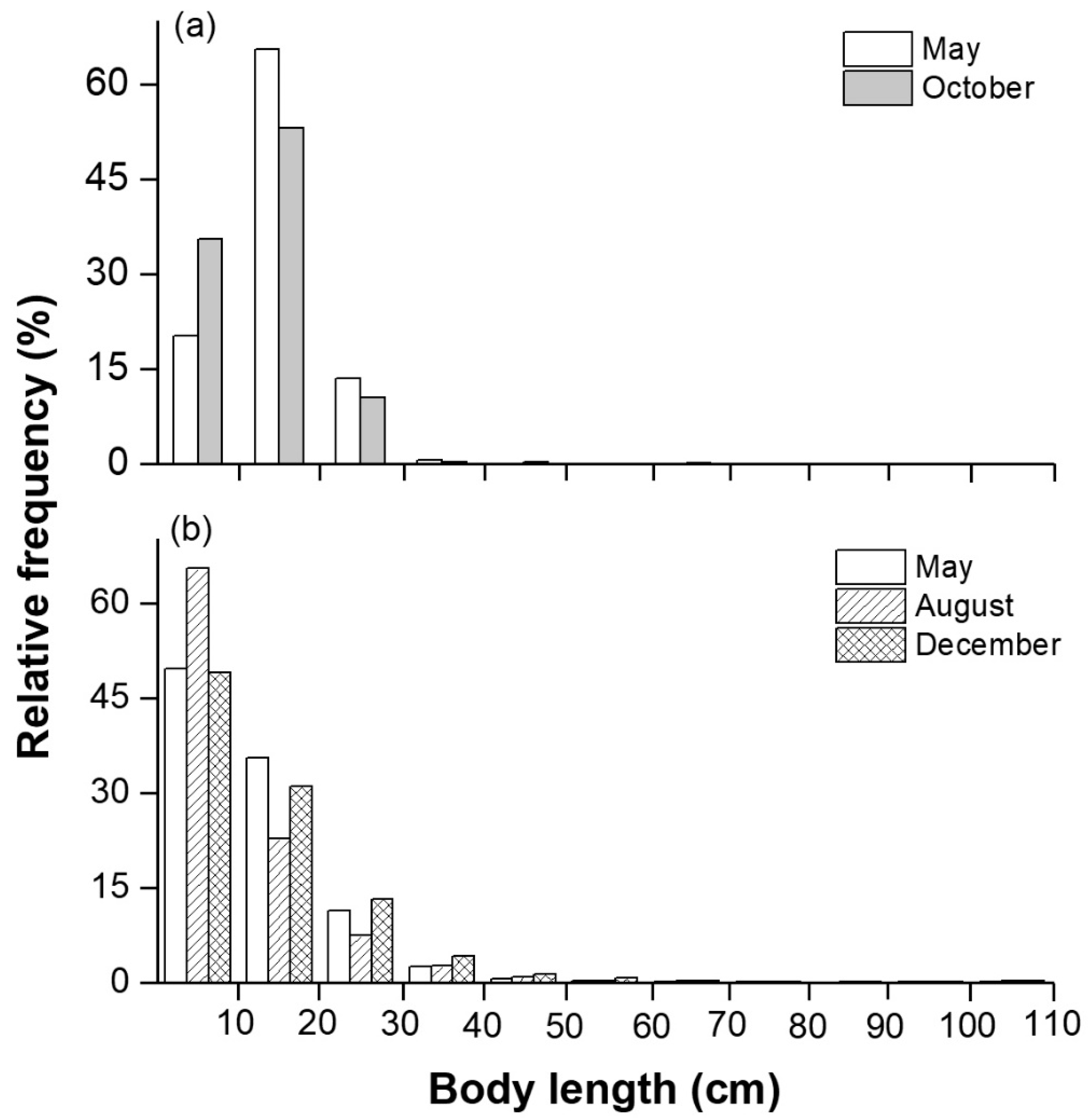
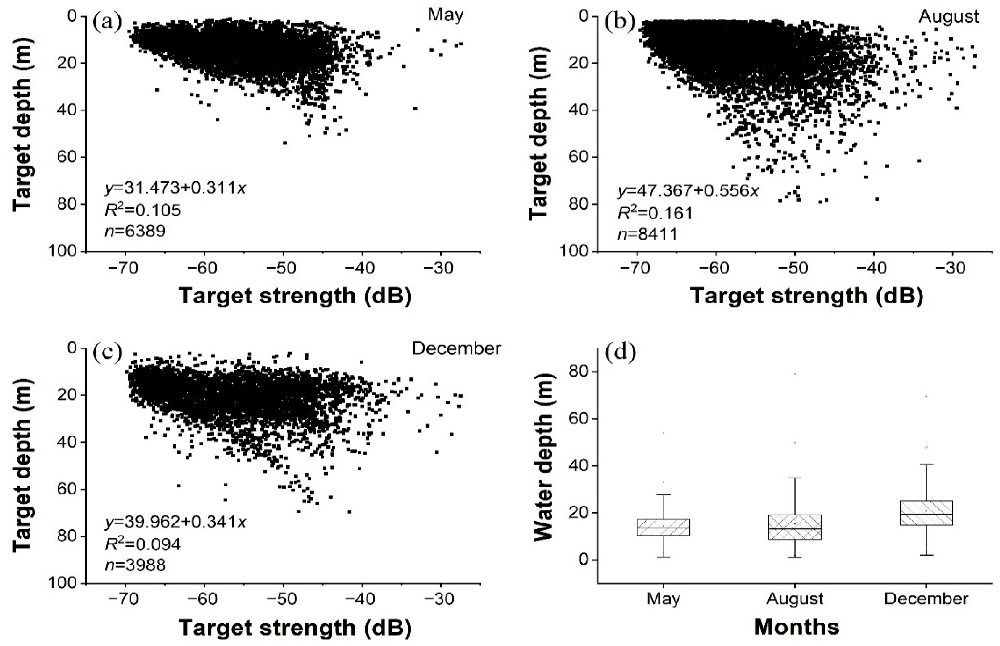
3.3. Biological and Acoustic Fish Lengths

The average and standard deviation (SD) of total length from biological samplings in May was 15.0 ± 5.1 cm, ranging from 2.3 to 51.5 cm, and that of total length in October was 13.4 ± 6.1 cm, ranging from 2.4 to 86.6 cm. The length–frequency distribution between the two months was significantly different (H = 166.1, p < 0.05). The proportion of individuals with TL < 10 cm was lower in May (20.3%) than October (35.6%), whereas the proportion of individuals with TL = 10–20 cm was higher in May (65.5%) than October (53.1%; Figure 3a).
The average and SD of target strength (TS) values in May, August, and December were −55.6 ± 6.2, −57.8 ± 6.9, and −55.8 ± 7.7 dB, respectively. The converted fish lengths from Equation (1) for the three months were 12.5 ± 8.9, 10.9 ± 11.0, and 13.5 ± 12.0 cm, respectively (Figure 3b). We compared the measured lengths from the biological samples and found that the fish lengths converted from acoustic data had a relatively wide size spectrum. Length–frequency distributions were also significantly different among the three months (H = 574.8, p < 0.05). The proportion of individuals with TL < 10 cm was higher in August (65.5%) than May (49.6%) or December (49.0%) (post hoc multiple comparison, p < 0.05; Figure 3b).

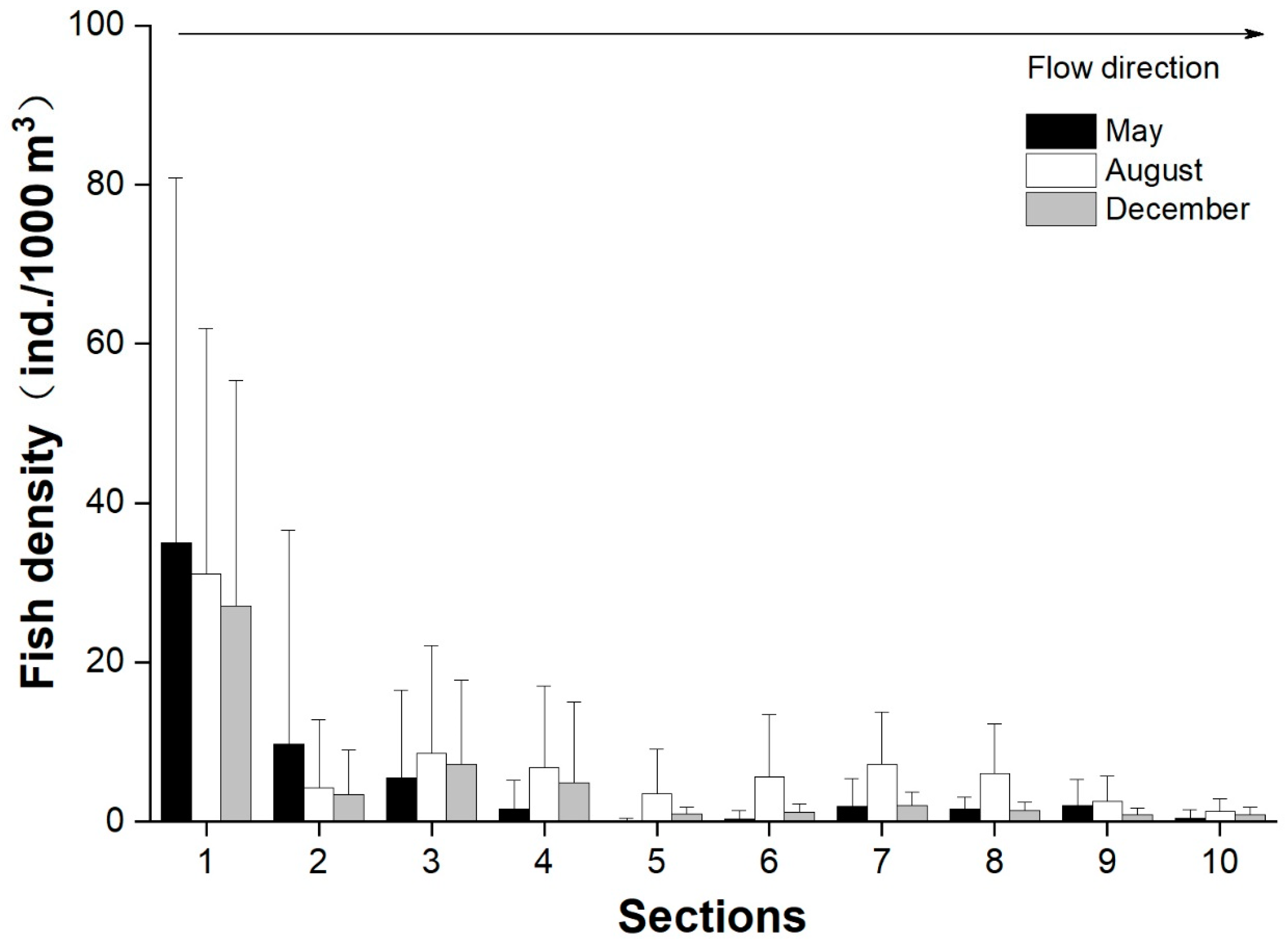
3.4. Longitudinal and Vertical Distributions of Fish

In the Mudong reach, the average and SD of fish density was 5.0 ± 18.1 in May, 7.0 ± 13.4 in August, and 4.4 ± 11.6 ind/1000 m3 in December. Fish density was significantly different among the three months (H = 483.1, p < 0.05), and the fish density during the flooding period was significantly higher than that during the non-flooding period (post hoc multiple comparison, p < 0.05). Longitudinally, the distribution of fish in the Mudong reach was patchy (Figure 4 and Figure 5). The highest density was observed in Section 1 for all three months, followed by Section 3 in August and Section 2 in May (Figure 4). Fish had the most even distribution in August, which is the natural flooding period. In December, when the water temperature dropped, fish were found to be aggregated in Sections 1 and 3 (Figure 5 and Table 1). Overall, the fish density was considerably higher in the meandering sections upstream than in the relatively strait sections downstream. A strong positive correlation was observed between fish densities and average water depth in each section (p < 0.05).
The average ± SD of the target depth was 14.2 ± 5.9 (range 2.1–53.9) in May, 15.2 ± 9.5 (range 2.0–79.1) in August, and 21.0 ± 8.6 m (range 2.1–69.6 m) in December (Figure 6). A range of 45.2–65.2% of the individuals detected over the three months was found at 10–20 m deep. Significant differences were also found when comparing the target depth among the three months (H = 2037.0, p < 0.05). The target depth in December was significantly higher than that in May and August (post hoc multiple comparisons, p < 0.05), and no significant difference occurred between May and August. The target depth was highest in December, indicating that fish preferred overwintering in deeper waters. The relationship between target strength and target depth is shown in Figure 6. The greater the target depth, the larger the TS became (p < 0.05), indicating a size-dependent vertical distribution pattern in which larger fish resided in deeper water and smaller fish resided in shallower water.

4. Discussion

4.1. Fish Distribution and Relevant Environmental Factors

This study is the first to reveal the spatial distribution of fish in the transitional zone of the Three Gorges Reservoir (TGR) using a hydroacoustic technique. The highest fish density was clearly observed in Section 1 (near Yuzui) for all three months. More patches and higher fish density occurred during the flooding season (August).
Variations in the spatiotemporal distribution of fish can be attributed to abiotic, biotic, and anthropogenic factors such as water temperature, water depth, channel morphology, substrate composition, flow velocity, and dam impoundment [38,39,40,41]. There are several factors that may explain this fish distribution in the Mudong reach.
First, channel morphology was an important element affecting the distribution of aquatic biota because it governed habitat quality, particularly the in-stream habitat complexity and food abundance. Meandering channels form diverse longitudinal and cross-sectional profiles. Such diverse bathymetric features produce habitat heterogeneity with high hydrological variability and diversity in substrate types, such as a lateral gradient of depth from shallow to deep areas and repeated structures of pools and riffles, where the sedimentation of suspended particles, including drifting forage organisms, takes place [42]. Field studies and river restoration case studies have shown that a large variety of habitat conditions and sufficient food provisions at such areas support high diversity and abundance of aquatic organisms such as fish and macroinvertebrates [40,42]. Conversely, a number of fish do not prefer to reside in the straight reach with the simple structure and high flow velocity [40]. Accordingly, in the present study, the fish densities were considerably higher in Sections 1, 3 and 4, which had strongly meandering channel morphologies, than in the relatively strait sections.
Second, deep pools have been found to play an important role in the breeding and growth of the fish community [42,43,44,45]. Deep pools support slow velocities and coarse substrates, which allow food to accumulate and increase bottom-food production. An important ecological characteristic of the Upper Yangtze fish fauna is the large proportion of bottom-dwelling fish with insectivorous feeding habits. Rhinogobio cylindricus, belonging to this ecological guild and dominant species in Mudong reach, preferred this type of habitat. Meanwhile, deep pools like those near Yuzui might act as a refuge from predators and major disturbances such as overfishing and intensive ship traffic. In addition, many small fish are well adapted to low-gradient, slow-flow habitats. Thus, some fish, such as Squalidus argentatus, Saurogobio dabryi, and Pelteobagrus fulvidraco preferred this type of habitat near Mudong Town. Harvey and Stewart [46] reported that minnows survived longer in pools than riffles and runs. Spina [47] also showed that trout selected locations based on depth and longitudinal position in the North Fork River (California, USA). Apart from this, more patches were found in Sections 6, 7, and 8 in August because a large number of fish larvae aggregated in the deep nearshore waters in the present study (Figure 5). The presence of fish larvae such as R. cylindricus, P. vachelli, and Hemiculter bleekeri near the shore might be a common phenomenon in temperate waters. Remaining close to the shore may make it easier to find a suitable settlement habitat and give the fish a more productive environment to grow in [48].
Third, fish formed tiny aggregations in December which could be attributed to their overwintering behavior. These fish are poikilothermic, so their body temperatures vary with the external environment. When water temperature declines from fall into winter, metabolic processes slow down, and the fish’s abilities to swim, feed, avoid predators, and defend their locations also decline [39]. Therefore, fish may aggregate in deeper areas with slower water velocities to increase survivorship. This behavior has been observed in cyprinid fish and riverine salmonids [49,50].
Furthermore, in this study, we found a higher fish density in August than in May and December, since many pelagic larval fish drift into the transitional zone and grow there during the flooding season [7,51]. Previous studies have reported that three spawning grounds in the national nature reserve for rare and endemic fish of the Upper Yangtze River were located upstream of the Mudong reach [51]. When the water level increased during the late spring and summer, at least 28 fish species—including four major Chinese carps, Sinibotia superciliaris, R. giurinus, Leptobotia elongate, Lepturichthys fimbriata, and C. guichenoti—spawned in the reserve [51,52].
The results and implications of this local study may also benefit other fields of science and aquatic environments. For example, Zhang et al. [53] demonstrated that the development of fisheries and biodiversity conservation for the past 70 years in Chinese inland waters could serve as a leading example for global inland aquatic biodiversity. A local study of both freshwater and marine environments can have implications for broader research on these environments in other regions. Kang et al. [54] exhibited that a study of a small region of the Terra Nova Bay Polynya (<2000 km2) could (i) help understand the vertical and horizontal distributions of krill and (ii) find correlations between the observed patterns and the dominant environmental attributes; their results led them to infer krill dynamics in the Ross Sea, Antarctica. In this context, we believe that cumulative localized research results can lead to the comprehensive realization on the relevant ecosystem.

4.2. Species Compositions and Fish Sizes

Many studies have reported that the impoundment of large dams in the Yangtze River result in substantial changes in the species compositions of upstream fish assemblages [7,17,20]. In the TGR, long-term catch data from the Mudong reach indicated that fish assemblage regime shifts had occurred in 2008 [20]. The present study also found that the relative abundance of dominant fish species was considerably different compared to that before the impoundment (1997–2002). For instance, C. guichenoti accounted for 30.0% of the fish abundance before the impoundment (1997–2002), but it dropped to 15.19% in 2006–2009 and <1% in 2017 [7]. The relative abundance of C. heterodon also showed a declining trend. However, the relative abundance of R. cylindricus increased in the Mudong reach, starting at 6.94% of the total individuals in 1997–2002 and increasing to 19.80% in 2006–2009, then to 30% in 2017 [7]. The changes in the dominant fish populations resulted from the construction of the dams in the Lower Jinsha River, such as the Xiangjiaba Dam [55]. These dams blocked the spawning migration route of fish, such as C. guichenoti, which used to be the dominant fish in the upper Yangtze, but were decreased in population size. Thus, R. cylindricus which has similar niches and is a competitor to C. guichenoti started to occupy its habitats and replace it as the dominant species [56].
A predominance of small individuals (<20 cm long) in the Mudong reach was verified by the high proportion of lower TS values and smaller fish lengths sampled. Previous studies have reported that transition zones in highly regulated rivers could serve as nursery habitats for juveniles or small fish [7,57,58]. In this study, fish size from biological samples showed that the Mudong reach could serve as a nursery habitat for at least six fish species (R. cylindricus, R. typus, S. dabryi, S. gymnocheilus, Leiocassis crassilabris and X. boulengeri). Furthermore, overfishing in the Yangtze River for last several decades have resulted in decreased abundance of large fish, leading to high abundance of small fish. Perera et al. [59] found that the length distribution of P. fluvidraco in the TGR was slanted towards smaller sizes and the spawning population only consisted of age classes 1 and 2.

4.3. Future Fish Monitoring and Conservation Suggestions for the Upper Yangtze River

Over the past few decades, the Yangtze River has been suffering a severe crisis of aquatic biodiversity due to dramatically decreasing fish resources [60,61]. The annual catch from the Yangtze River was more than 420 thousand tons in the 1950s, but fell to less than 100 thousand tons by the 2010s [60]. In 2017, a 10-year fishing ban for all 332 aquatic biota in the Yangtze River was implemented to protect and restore aquatic resources. This ban was extended to all major natural water bodies in the Yangtze River Basin until 2021 [19]. Under this background, traditional research methods like a net sampling will be further limited so that non-lethal techniques will become a main monitoring method. Our study demonstrates the feasibility of using hydroacoustic techniques to quantify fish density and spatial distributions in the Upper Yangtze River. The results of this study provide important background knowledge to support fish resources management. However, further research is needed to measure the target strength for dominant species in the Upper Yangtze River to attain an accurate target strength–fish length relationship.
The Upper Yangtze River is one of the largest hydropower development areas in China. There are currently 17 huge dams in the mainstream of the Upper Yangtze River—nine are operational and eight are under construction—and eight new dams are being planned. In the 800 km-long reach from Panzhihua to Yibin, for example, two large dams (Xiangjiaba Dam and Xiluodu Dam) have been constructed and another two (Baihetan Dam and Wudongde Dam) are under construction. When all four dams are operational, 95% of the free-flowing reach will be lost. Therefore, the transitional zone will become critical for fish species diversity in the Upper Yangtze River. Lastly, our results found that the meandering deep channels increase habitat heterogeneity and enhance fish abundance, and thus more attention should be paid to these areas in terms of conservation in highly regulated river systems.

Author Contributions

Conceptualization, P.L. and X.G. (Xin Gao); methodology, P.L. and X.G. (Xin Gao); validation, P.L.; formal analysis, P.L. and X.G. (Xingchen Gao); investigation, P.L., L.C., and X.G. (Xin Gao); data curation, P.L.; writing—original draft preparation, P.L. and C.W.; writing—review and editing, X.G. (Xin Gao) and M.K.; and visualization, P.L. and M.K. All authors have read and agreed to the published version of the manuscript.

Funding

This research was funded by the National Key Research and Development Program of China (No. 2018YFD0900806), the Open Project of Hubei Key Laboratory of Three Gorges Project for Conservation of Fishes (SXSN/4381), the National Natural Science Foundation of China (No. 51509239), and the Sino BON—Inland Water Fish Diversity Observation Network.

Acknowledgments

We thank Zhenfei Xing, Chen Zhang, Wenjing Li, and Xingcheng Luo for their assistance with the field work. Thanks also to Noah Last for his English language editing. We also gratefully acknowledge the reviewers for their valuable comments and suggestions on our manuscript.

Conflicts of Interest

The authors declare no conflict of interest.

References

  1. Cooke, S.J.; Martins, E.G.; Struthers, D.P.; Gutowsky, L.F.G.; Power, M.; Doka, S.E.; Dettmers, J.M.; Crook, D.A.; Lucas, M.C.; Holbrook, C.M.; et al. A moving target—Incorporating knowledge of the spatial ecology of fish into the assessment and management of freshwater fish populations. Environ. Monit. Assess. 2016, 188, 1–18. [Google Scholar] [CrossRef] [PubMed] [Green Version]
  2. Esselman, P.C.; Allan, J.D. Relative influences of catchment- and reach-scale abiotic factors on freshwater fish communities in rivers of northeastern Mesoamerica. Ecol. Freshw. Fish 2010, 19, 439–454. [Google Scholar] [CrossRef]
  3. Gerasimov, Y.V.; Borisenko, E.S.; Bazarov, M.I.; Stolbunov, I.A. Density and distribution of fish in a river with a pronounced heterogeneity of the environment: Hydroacoustic Survey. Inland Water Biol. 2019, 12, 69–75. [Google Scholar] [CrossRef]
  4. Wagner, T.; Midway, S.R.; Whittier, J.B.; Deweber, J.T.; Paukert, C.P. Annual changes in seasonal river water temperatures in the eastern and western United States. Water 2017, 9, 90. [Google Scholar] [CrossRef] [Green Version]
  5. Park, Y.-S.; Chang, J.; Lek, S.; Cao, W.; Brosse, S. Conservation strategies for endemic fish species threatened by the Three Gorges Dam. Conserv. Biol. 2003, 17, 1748–1758. [Google Scholar] [CrossRef]
  6. De Oliveira, E.F.; Goulart, E.; Minte-Vera, C.V. Fish diversity along spatial gradients in the Itaipu Reservoir, Paraná, Brazil. Braz. J. Biol. 2004, 64, 447–458. [Google Scholar] [CrossRef]
  7. Yang, S.; Gao, X.; Li, M.; Ma, B.; Liu, H.Z. Interannual variations of the fish assemblage in the transitional zone of the Three Gorges Reservoir: Persistence and stability. Environ. Boil. Fishes 2011, 93, 295–304. [Google Scholar] [CrossRef]
  8. Muška, M.; Tušer, M.; Frouzová, J.; Mrkvička, T.; Ricard, D.; Sed’a, J.; Morelli, F.; Kubečka, J. Real-time distribution of pelagic fish: Combining hydroacoustics, GIS and spatial modelling at a fine spatial scale. Sci. Rep. 2018, 8, 5381. [Google Scholar] [CrossRef]
  9. Simmonds, J.E.; Maclennan, D.N. Fisheries Acoustics: Theory and Practice, 2nd ed.; Blackwell: London, UK, 2005; p. 437. [Google Scholar]
  10. Kang, M. Overview of the applications of hydroacoustic methods in South Korea and fish abundance estimation methods. Fish. Aquat. Sci. 2014, 17, 369–376. [Google Scholar] [CrossRef] [Green Version]
  11. Pollom, R.A.; Rose, G.A. A global review of the spatial, taxonomic, and temporal scope of freshwater fisheries hydroacoustics research. Environ. Rev. 2016, 24, 333–347. [Google Scholar] [CrossRef]
  12. Myers, N.; Mittermeier, R.A.; Mittermeier, C.G.; Da Fonseca, G.A.B.; Kent, J. Biodiversity hotspots for conservation priorities. Nature 2000, 403, 853–858. [Google Scholar] [CrossRef] [PubMed]
  13. Qiao, Y.; Tang, X.; Brosse, S.; Chang, J. Chinese Sturgeon (Acipenser sinensis) in the Yangtze River: A hydroacoustic assessment of fish location and abundance on the last spawning ground. J. Appl. Ichthyol. 2006, 22, 140–144. [Google Scholar] [CrossRef]
  14. Lian, Y.; Ye, S.; Godlewska, M.; Huang, G.; Wang, J.; Chen, S.; Zhao, X.; Du, X.; Liu, J.; Li, Z. Diurnal, seasonal and inter-annual variability of fish density and distribution in the Three Gorges Reservoir (China) assessed with hydroacoustics. Limnologica 2017, 63, 97–106. [Google Scholar] [CrossRef]
  15. Li, J.; Zhang, H.; Lin, D.; Wu, J.; Wang, C.; Xie, X.; Wei, Q. Spatiotemporal distribution and assemblages of fishes below the lowermost dam in protected reach in the Yangtze River main stream: Implications for river management. BioMed Res. Int. 2016, 2016, 1–8. [Google Scholar] [CrossRef] [Green Version]
  16. Guo, A.; Yuan, J.; Chu, T.; Lian, Q. Hydroacoustic assessment of fish resources in three reservoirs: The effects of different management strategies on fish density, biomass and size. Fish. Res. 2019, 215, 90–96. [Google Scholar] [CrossRef]
  17. Lin, P.; Gao, X.; Liu, F.; Li, M.; Liu, H. Long-term monitoring revealed fish assemblage zonation in the Three Gorges Reservoir. J. Oceanol. Limnol. 2018, 37, 1258–1267. [Google Scholar] [CrossRef]
  18. Wu, X.; Qin, J.; Xu, Y.; Ouyang, S.; Wu, X. Biodiversity decline of fish assemblages after the impoundment of the Three Gorges Dam in the Yangtze River Basin, China. Rev. Fish Biol. Fish. 2019, 29, 177–195. [Google Scholar] [CrossRef]
  19. Chen, Y.; Qu, X.; Xiong, F.; Lu, Y.; Wang, L.; Hughes, R.M. Challenges to saving China’s freshwater biodiversity: Fishery exploitation and landscape pressures. Ambio 2019, 49, 926–938. [Google Scholar] [CrossRef]
  20. Gao, X.; Fujiwara, M.; Winemiller, K.O.; Lin, P.; Li, M.; Liu, H.Z. Regime shift in fish assemblage structure in the Yangtze River following construction of the Three Gorges Dam. Sci. Rep. 2019, 9, 4212. [Google Scholar] [CrossRef]
  21. Yi, B.L.; Yu, Z.T.; Liang, Z.X. Gezhouba Water Control Project and Four Famous Chinese Carps in the Yangtze River; Hubei Science & Technology Press: Wuhan, China, 1988; p. 116. [Google Scholar]
  22. Liu, L.H.; Wu, G.X.; Wang, Z.L. Reproduction ecology of Coreius Heterodon (Bleeker) and Coreius Guichenoti (Sauvage et Dabry) in the mainstream of the Changjiang River after the construction of Gezhouba Dam. Acta Hydrobiologia Sinica 1990, 14, 205–215. [Google Scholar]
  23. The Website of National Hydrological and Rainfall Information. Available online: http://xxfb.mwr.cn/sq_djdh.html (accessed on 31 December 2017).
  24. Foote, K.G.; Knudsen, H.P.; Vestnes, G.; MacLennan, D.N.; Simmonds, E.J. Calibration of Acoustic Instruments for Fish Density Estimation: A Practical Guide; ICES Cooperative Research Report; ICES Cooperative Research: Copenhagen, Denmark, 1987; p. 144. [Google Scholar]
  25. Aglen, A. Random Errors of Acoustic Fish Abundance Estimates in Relation to the Survey Grid Density Applied; FAO Fisheries Report; FAO Fisheries: Rome, Italy, 1983; pp. 293–298. [Google Scholar]
  26. Godlewska, M.; Długoszewski, B.; Doroszczyk, L.; Jóźwik, A. The relationship between sampling intensity and sampling error—Empirical results from acoustic surveys in Polish vendace lakes. Fish. Res. 2009, 96, 17–22. [Google Scholar] [CrossRef]
  27. Guillard, J.; Vergès, C. The repeatability of fish biomass and size distribution estimates obtained by hydroacoustic surveys using various survey designs and statistical analyses. Int. Rev. Hydrobiol. 2007, 92, 605–617. [Google Scholar] [CrossRef]
  28. Yang, S.; Gao, X.; Ma, B.; Kong, Y.; Liu, H. Seasonal dynamics of fish community in Mudong section of the Three Gorges Reservoir of the Yangtze River, China. Chin. J. Appl. Environ. Biol. 2010, 16, 555–560. [Google Scholar]
  29. Ding, R.H. The fishes of Sichuan, China; Sichuan Publishing House of Science and Technology: Chengdu, China, 1994; p. 641. [Google Scholar]
  30. Balk, H.; Lindem, T. Sonar4 and Sonar5 Post Processing Systems, Operator Manual v5.9.4; University of Oslo: Oslo, Norway, 2004; p. 405. [Google Scholar]
  31. Parker-Stetter, S.L.; Rudstam, L.G.; Sullivan, P.J.; Warner, D.M. Standard Operating Procedures for Fisheries Acoustic Surveys in the Great Lakes; Great Lakes Fisheries Commission Special Publication, 09–01; Great Lakes Fisheries Commission: Ann Arbor, MI, USA, 2009. [Google Scholar]
  32. Tušer, M.; Kubečka, J.; Frouzová, J.; Jarolím, O. Fish orientation along the longitudinal profile of the Římov reservoir during daytime: Consequences for horizontal acoustic surveys. Fish. Res. 2009, 96, 23–29. [Google Scholar] [CrossRef]
  33. Frouzova, J.; Kubecka, J.; Balk, H.; Frouz, J. Target strength of some European fish species and its dependence on fish body parameters. Fish. Res. 2005, 75, 86–96. [Google Scholar] [CrossRef]
  34. Rodríguez-Sánchez, V.; Encina-Encina, L.; Ruiz, A.R.; Sánchez-Carmona, R. Horizontal target strength of Luciobarbus sp. in ex situ experiments: Testing differences by aspect angle, pulse length and beam position. Fish. Res. 2015, 164, 214–222. [Google Scholar] [CrossRef]
  35. De Robertis, A.; McKelvey, D.R.; Ressler, P.H. Development and application of an empirical multifrequency method for backscatter classification. Can. J. Fish. Aquat. Sci. 2010, 67, 1459–1474. [Google Scholar] [CrossRef]
  36. Kang, M.; Furusawa, M.; Miyashita, K. Effective and accurate use of difference in mean volume backscattering strength to identify fish and plankton. ICES J. Mar. Sci. 2002, 59, 794–804. [Google Scholar] [CrossRef] [Green Version]
  37. Korneliussen, R.J.; Ona, E. Synthetic echograms generated from the relative frequency response. ICES J. Mar. Sci. 2003, 60, 636–640. [Google Scholar] [CrossRef]
  38. Abes, S.D.S.; Agostinho, A.A. Spatial patterns in fish distributions and structure of the ichthyocenosis in the Água Nanci stream, upper Paraná River basin, Brazil. Hydrobiologia 2001, 445, 217–227. [Google Scholar] [CrossRef]
  39. Senay, C.; Macnaughton, C.J.; Lanthier, G.; Harvey-Lavoie, S.; Lapointe, M.; Boisclair, D. Identifying key environmental variables shaping within-river fish distribution patterns. Aquat. Sci. 2015, 77, 709–721. [Google Scholar] [CrossRef]
  40. Nagayama, S.; Nakamura, F. The significance of meandering channel to habitat diversity and fish assemblage: A case study in the Shibetsu River, northern Japan. Limnology 2017, 19, 7–20. [Google Scholar] [CrossRef] [Green Version]
  41. Hou, Y.; Yang, Z.; An, R.; Cai, L.; Chen, X.; Zhao, X.; Zou, X. Water flow and substrate preferences of Schizothorax wangchiachii (Fang, 1936). Ecol. Eng. 2019, 138, 1–7. [Google Scholar] [CrossRef]
  42. Garcia, X.-F.; Schnauder, I.; Pusch, M.T. Complex hydromorphology of meanders can support benthic invertebrate diversity in rivers. Hydrobiology 2012, 685, 49–68. [Google Scholar] [CrossRef]
  43. Baird, I.G. Strength in diversity: Fish sanctuaries and deep-water pools in Lao PDR. Fish. Manag. Ecol. 2006, 13, 1–8. [Google Scholar] [CrossRef]
  44. Lin, P.C.; Gao, X.; Zhu, Q.G.; Wang, T.; Liu, H.Z. Hydroacoustic survey on the spatial distribution pattern and day-night rhythmic behaviour of fishes in the Xiaonanhai reach of the upper Yangtze River. J. Appl. Ichthyol. 2013, 29, 1402–1407. [Google Scholar] [CrossRef]
  45. Vašek, M.; Prchalová, M.; Říha, M.; Blabolil, P.; Čech, M.; Draštík, V.; Frouzová, J.; Jůza, T.; Kratochvíl, M.; Muška, M.; et al. Fish community response to the longitudinal environmental gradient in Czech deep-valley reservoirs: Implications for ecological monitoring and management. Ecol. Indic. 2016, 63, 219–230. [Google Scholar] [CrossRef]
  46. Harvey, B.C.; Stewart, A.J. Fish size and habitat depth relationships in headwater streams. Oecologia 1991, 87, 336–342. [Google Scholar] [CrossRef]
  47. Spina, A.P. Habitat partitioning in a patchy environment: Considering the role of intraspecific competition. Environ. Boil. Fishes 2000, 57, 393–400. [Google Scholar] [CrossRef]
  48. Beldade, R.; Borges, R.; Gonçalves, E.J. Depth distribution of nearshore temperate fish larval assemblages near rocky substrates. J. Plankton Res. 2006, 28, 1003–1013. [Google Scholar] [CrossRef]
  49. Brown, R.S.; Hubert, W.A.; Daly, S.F. A primer on winter, ice, and fish: What fisheries biologists should know about winter ice processes and stream-dwelling fish. Fisheries 2011, 36, 8–26. [Google Scholar] [CrossRef]
  50. Wolter, C. Temperature influence on the fish assemblage structure in a large lowland river, the lower Oder River, Germany. Ecol. Freshw. Fish 2007, 16, 493–503. [Google Scholar] [CrossRef]
  51. Jiang, W.; Liu, H.-Z.; Duan, Z.-H.; Cao, W.-X. Seasonal variation in drifting eggs and larvae in the upper Yangtze, China. Zool. Sci. 2010, 27, 402–409. [Google Scholar] [CrossRef] [PubMed] [Green Version]
  52. Tang, X.L. Studies on early fish resources in Jiangjin cross-section in the Upstream of Yangtze River. Master’s Thesis, Southwest University, Chongqing, China, 2010. [Google Scholar]
  53. Zhang, H.; Wu, J.; Gorfine, H.; Shan, X.; Shen, L.; Yang, H.; Du, H.; Li, J.; Wang, C.; Zhou, Q.; et al. Inland fisheries development versus aquatic biodiversity conservation in China and its global implications. Rev. Fish Biol. Fish. 2020, 30, 637–655. [Google Scholar] [CrossRef]
  54. Kang, M.; Fajaryanti, R.; Son, W.; Kim, J.H.; La, H.S. Acoustic setection of krill scattering layer in the Terra Nova Bay Polynya, Antarctica. Front. Mar. Sci. 2020, 7, 584550. [Google Scholar] [CrossRef]
  55. Cheng, F.; Li, W.; Castello, L.; Murphy, B.R.; Xie, S. Potential effects of dam cascade on fish: Lessons from the Yangtze River. Rev. Fish Biol. Fish. 2015, 25, 569–585. [Google Scholar] [CrossRef]
  56. Liu, F.; Wang, J.; Liu, H.-Z. Seasonal variations in food resource partitioning among four sympatric gudgeon species in the upper Yangtze River. Ecol. Evol. 2019, 9, 7227–7236. [Google Scholar] [CrossRef] [Green Version]
  57. Terra, B.D.F.; Dos Santos, A.B.I.; Araújo, F.G. Fish assemblage in a dammed tropical river: An analysis along the longitudinal and temporal gradients from river to reservoir. Neotrop. Ichthyol. 2010, 8, 599–606. [Google Scholar] [CrossRef] [Green Version]
  58. Buckmeier, D.L.; Smith, N.G.; Fleming, B.P.; Bodine, K.A. Intra-annual variation in river-reservoir interface fish assemblages: Implications for fish conservation and management in regulated rivers. River Res. Appl. 2013, 30, 780–790. [Google Scholar] [CrossRef]
  59. Perera, H.A.C.C.; Rypel, A.L.; Murphy, B.R.; Li, Z.; Xia, Y.; Liu, J. Population characteristics of yellow catfish (Pelteobagrus fulvidraco) along the longitudinal profile of Three Gorges Reservoir, China. J. Appl. Ichthyol. 2013, 29, 1061–1066. [Google Scholar] [CrossRef]
  60. Chen, D.; Xiong, F.; Wang, K.; Chang, Y. Status of research on Yangtze fish biology and fisheries. Environ. Boil. Fishes 2009, 85, 337–357. [Google Scholar] [CrossRef]
  61. Huang, L.; Li, J. Status of freshwater fish biodiversity in the Yangtze River Basin, China. In Aquatic Biodiversity Conservation and Ecosystem Services; Nakano, S., Yahara, T., Nakashizuka, T., Eds.; Springer: Singapore, 2016; pp. 13–30. [Google Scholar]
Figure 1. Map of the study area in the Mudong reach located in the transitional zone of the Three Gorge Reservoir. The green zigzag line represents the hydroacoustic transect line. The star mark in black on the upper left panel indicates the study area. The black and red dots indicate major cities and towns.
Water 12 03514 g001
Figure 2. Water discharge and water temperature in the Mudong reach in 2017. Arrows indicate the hydroacoustic surveys.
Water 12 03514 g002
Figure 3. Fish length distribution from net catches (a) and converted acoustic target strength (b).
Water 12 03514 g003
Figure 4. Fish density in the Mudong reach in relation to the flow direction in May, August, and December. The 20-km Mudong reach was divided into 2-km-long sections.
Water 12 03514 g004
Figure 5. Interpolated water depth (m, above) and fish density (ind./1000 m3, below) in Mudong reach. The left panels are in May (a,d), middle in August (b,e), and right in December (c,f). Ten sections were marked by dividing the 20-km-long Mudong reach into 2-km-long sections in the flow direction.
Water 12 03514 g005
Figure 6. Scatter plots of target strength against target depth in May (a), August (b), and December (c). Water depth for three months (d) is shown with a boxplot.
Water 12 03514 g006
Table 1. Parameters of environment and hydroacoustic surveys at the Mudong reach.
Sampling PeriodAverage Water Depth (m)Maximum Water Depth (m)Water Temperature (°C)Total Sailing Distance (km)Degree of Coverage
22–23 May13.160.021.670.914.5
30–31 August20.481.025.770.214.4
9–10 December23.973.015.193.519.2
Table 2. Summary of fish biological samplings at the Mudong reach.
Sampling PeriodTotal Mass (kg)Number of Boat Days
13–29 May199.231
26 September–9 October193.124
Table 3. Percentages by mass and number of fish, mean total length and mass, and ecological group based on fish species from biological samplings.
SpeciesMayOctoberMean TL (mm)Mean W (g)Ecological Group
W%N%W%N%
Rhinogobio cylindricus (Günther) *43.529.943.642.615864Rheophilic
Coreius heterodon (Bleeker)18.96.16.71.7219165Rheophilic
Hemiculter bleekeri (Warpachowski)9.130.70.00.110418Limnophilic
Leiocassis crassilabris (Günther)5.24.21.31.713456Eurytopic
Squalidus argentatus (Sauvage and Dabry)3.511.4----9116Eurytopic
Hemiculter leucisculus (Basilewsky)3.07.9----10721Limnophilic
Leiocassis longirostris (Günther)2.80.50.30.0266310Rheophilic
Cyprinus carpio (Linnaeus)2.70.211.30.33591429Limnophilic
Siniperca chuatsi (Basilewsky)1.80.30.10.0215269Limnophilic
Culter mongolicus (Basilewsky)1.40.10.10.0291606Limnophilic
Pseudolaubuca sinensis (Bleeker)1.10.4----211118Limnophilic
Pelteobagrus vachelli (Richardson)1.00.73.13.714152Eurytopic
Myxocyprinus asiaticus (Bleeker)0.80.0----3701550Rheophilic
Rhinogobio typus (Bleeker)0.70.53.47.212630Rheophilic
Parabramis pekinensis (Basilewsky)0.50.0----3821094Eurytopic
Culter alburnus (Basilewsky)0.50.1----303360Limnophilic
Megalobrama skolkovii (Dybowski) **0.50.0----287528Limnophilic
Squaliobarbus curriculus (Richardson)0.40.10.10.0228244Eurytopic
Silurus asotus (Linnaeus)0.40.06.60.6300581Limnophilic
Pseudobrama simoni (Bleeker)0.31.1----9316Limnophilic
Pelteobagrus nitidus (Sauvage and Dabry)0.31.00.71.510720Eurytopic
Mystus macropterus (Bleeker)0.30.12.910.711623Rheophilic
Coreius guichenoti (Sauvage and Dabry) *0.30.12.00.6215193Rheophilic
Gobiobotia filifer (Garman)0.31.40.32.5768Rheophilic
Ctenopharyngodon idella (Cuvier and Valenciennes)0.20.00.00.0178131Eurytopic
Saurogobio gymnocheilus (Lo, Yao and Chen)0.21.0----879Eurytopic
Leptobotia elongata (Bleeker) *0.10.02.38.89723Rheophilic
Saurogobio dabryi (Bleeker)0.10.70.10.3699Eurytopic
Mylopharyngodon piceus (Richardson)0.00.10.60.0193330Eurytopic
Coilia brachygnathus (Kreyenberg and Pappenheim) **0.00.0----23046Limnophilic
Hemiculter tchangi (Fang) *0.00.1----10411Rheophilic
Pseudobagrus truncatus (Regan)0.00.1----6510Eurytopic
Rhinogobius giurinus (Rutter)0.00.50.00.0412Limnophilic
Pseudolaubuca engraulis (Nichols)0.00.0----11919Limnophilic
Misgurnus anguillicaudatus (Cantor)0.00.0----13430Limnophilic
Pelteobagrus fulvidraco (Richardson)0.00.0----11628Limnophilic
Glyptothorax fokiensis (Rendahl)0.00.1----593Rheophilic
Parabotia fasciata (Dabry)0.00.00.00.19312Rheophilic
Glyptothorax sinensis (Regan)0.00.10.00.1594Rheophilic
Sinogastromyzon szechuanensis (Fang) *0.00.0----7813Rheophilic
Carassius potanini *0.00.0----858Rheophilic
Xenophysogobio boulengeri (Tchang) *0.00.01.09.1666Rheophilic
Liobagrus marginatoides (Wu) *0.00.0----472Rheophilic
Hypophthalmichthys molitrix (Cuvier and Valenciennes) 4.40.15582146Eurytopic
Silurus meridionalis (Chen) 4.10.08667850Limnophilic
Carassius auratus (Linnaeus) 3.41.5145125Limnophilic
Leptobotia taeniops (Sauvage) 0.84.68411Eurytopic
Procypris rabaudi (Tchang) * 0.20.1204235Rheophilic
Megalobrama pellegrini (Tchang) * 0.10.0195143Rheophilic
Pseudobagrus emarginatus (Regan) 0.10.111231Eurytopic
Leptobotia microphthalma (Fu and Ye) * 0.10.8644Rheophilic
Rhinogobio ventralis (Sauvage and Dabry) * 0.00.19116Rheophilic
Siniperca kneri (Garman) 0.00.015878Limnophilic
Leptobotia rubrilabris (Dabry) * 0.00.1777Rheophilic
Saurogobio gracilicaudatus 0.00.16012Eurytopic
Paramisgurnus dabryanus 0.00.010819Limnophilic
Hybrid Sturgeon ** 0.00.013716Limnophilic
Botia superciliaris (Günther) 0.00.1695Rheophilic
Cirrhinus mrigala (Hamilton) ** 0.00.08110Limnophilic
Rhinogobius brunneus (Temminck and Schlegel) 0.00.0463Limnophilic
Lepturichthys fimbriata (Günther) 0.00.0581Rheophilic
N: Percentage by number; W: Percentage by mass; TL: Total length; W: Body mass; “*” indicates an endemic fish species; “**” indicates an exotic fish species.
Publisher’s Note: MDPI stays neutral with regard to jurisdictional claims in published maps and institutional affiliations.

