The Subsurface Geology and Landscape Evolution of the Volturno Coastal Plain, Italy: Interplay between Tectonics and Sea-Level Changes during the Quaternary

 ,
,  ,
,  ,
,  and
and 
Abstract
:1. Introduction
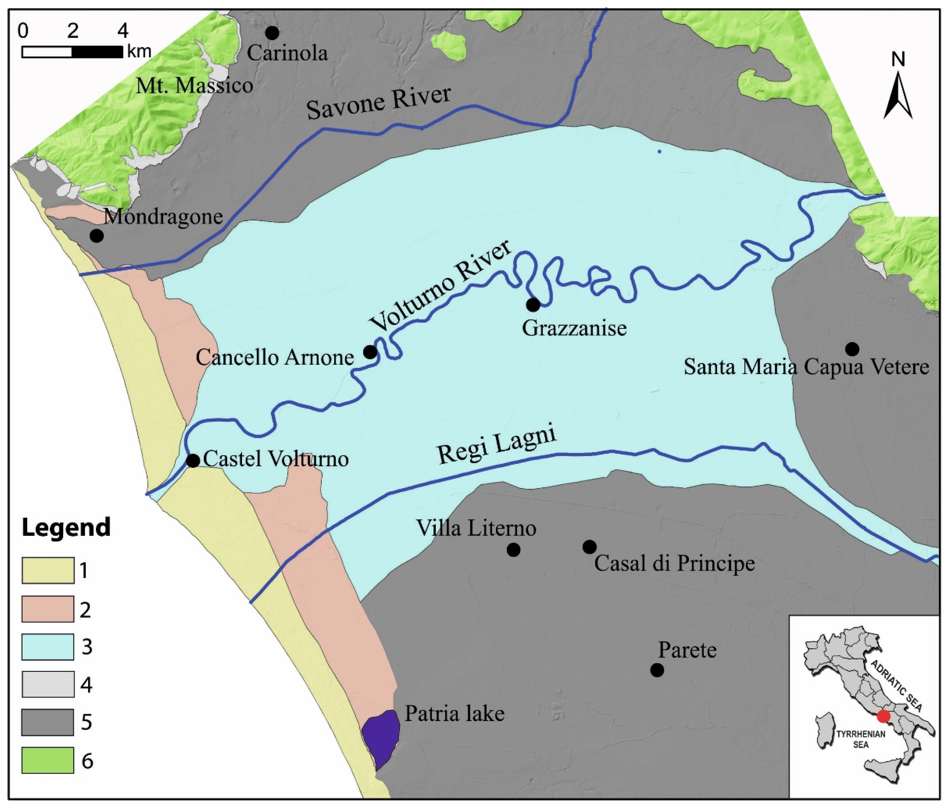
2. Large-scale Geological Setting and Morpho-Evolution
3. Previous Works
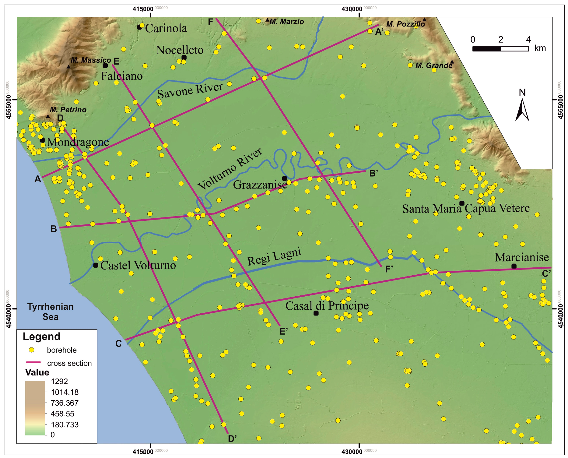
4. Materials and Methods
5. Results
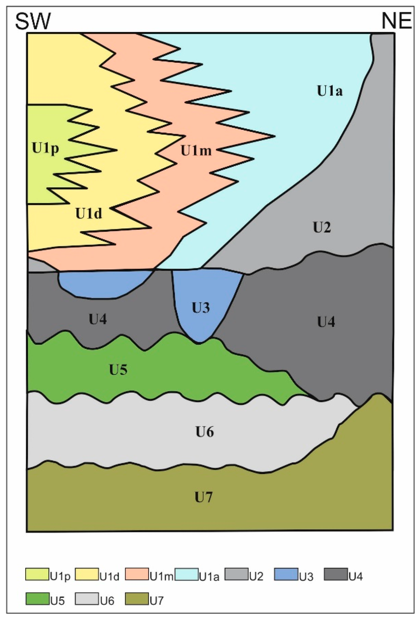
5.1. Stratigraphic Synopsis of the Late Quaternary Succession from the Volturno Plain
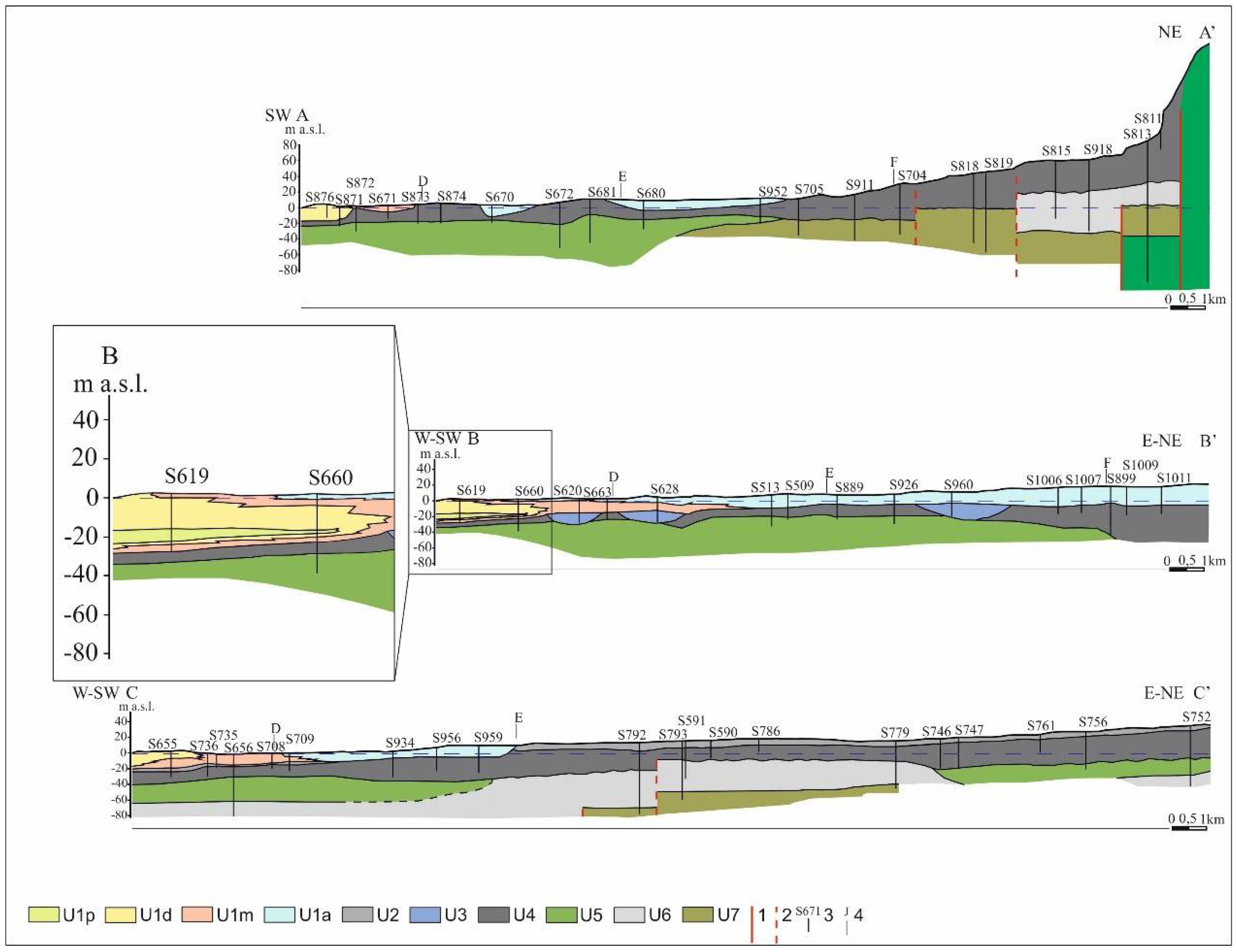
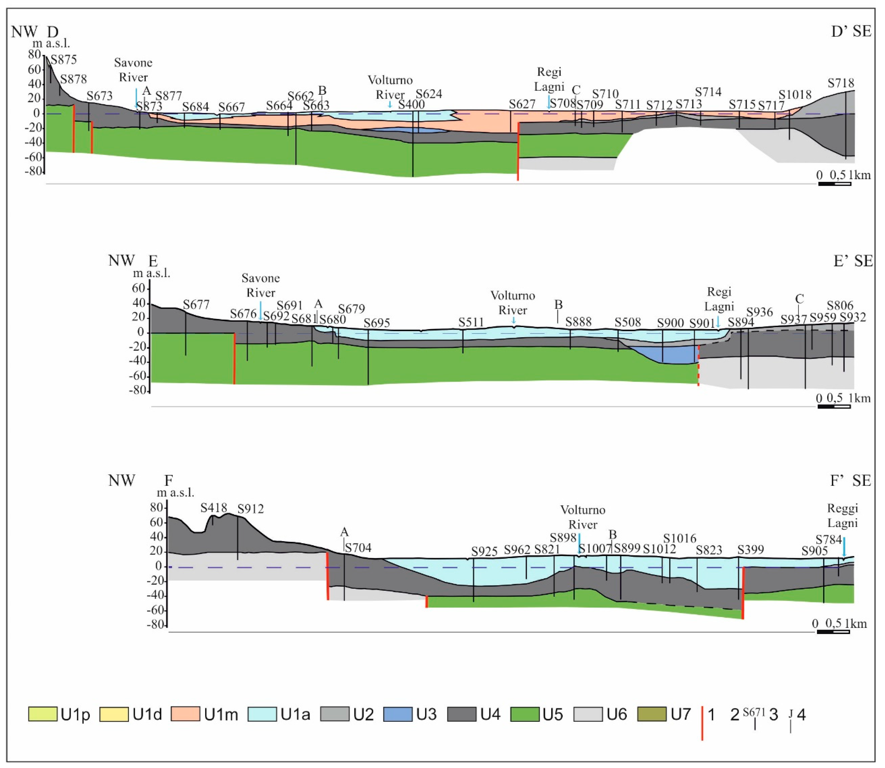
5.2. Geological Cross Sections
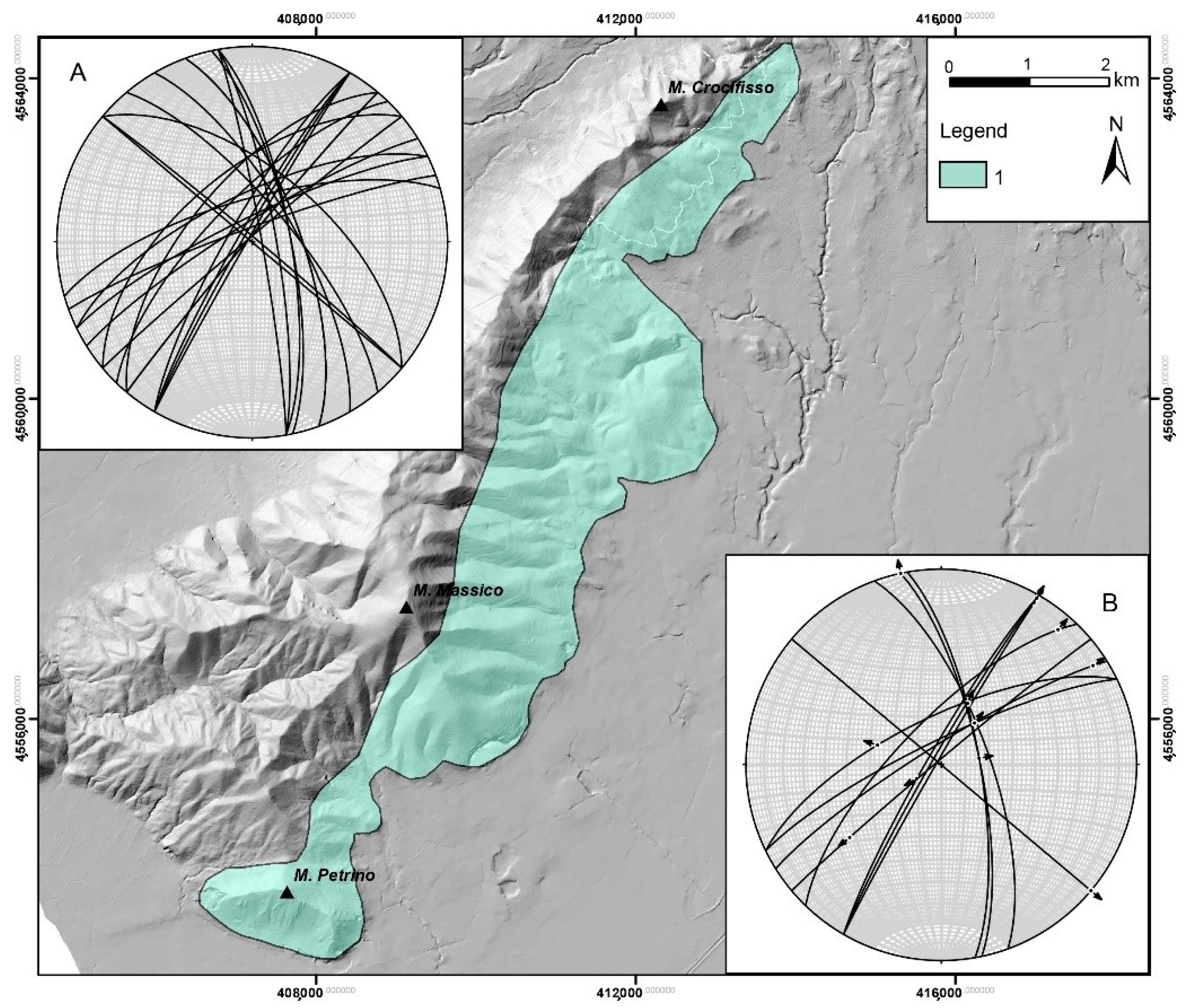
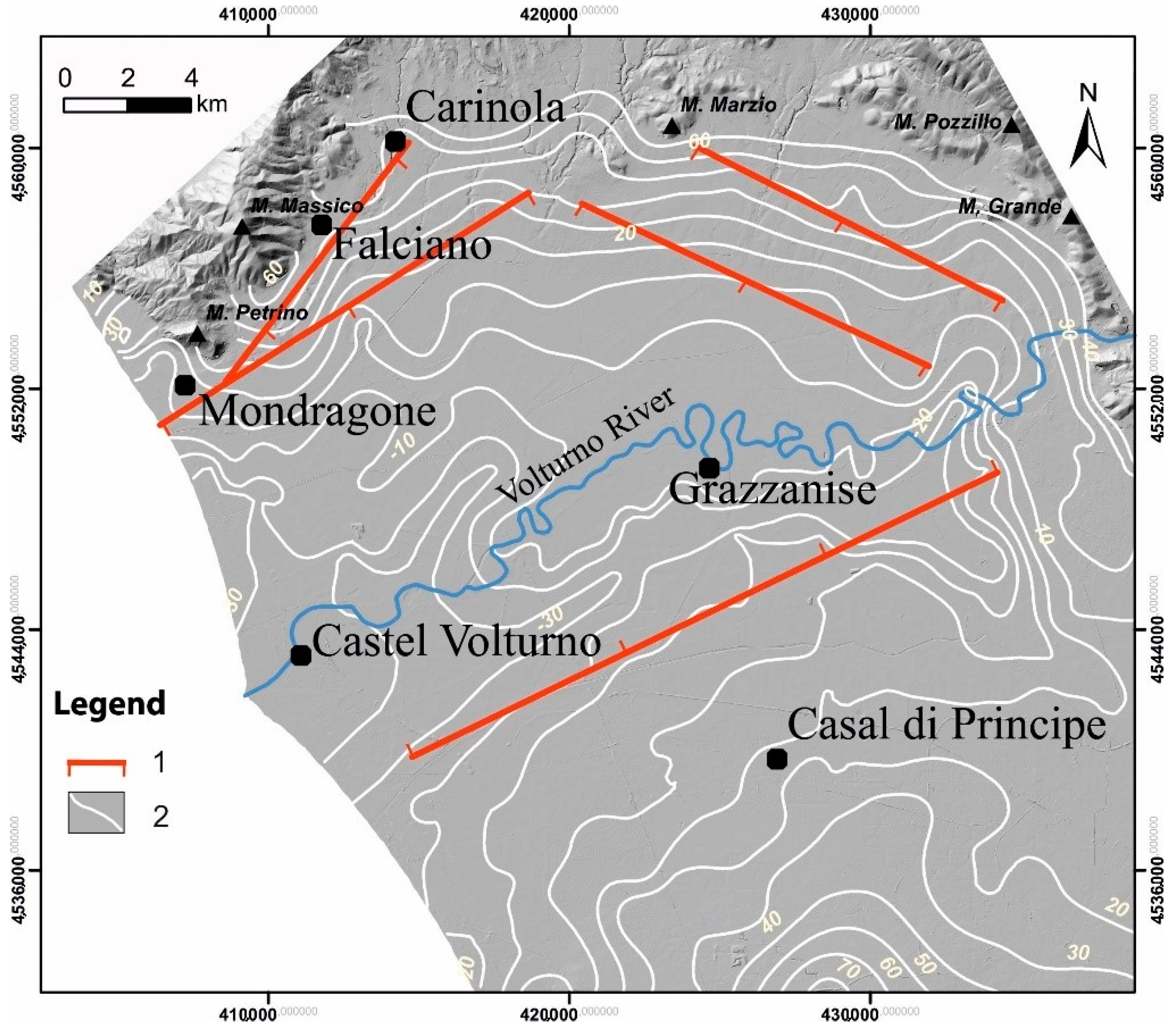
5.3. Tectonics
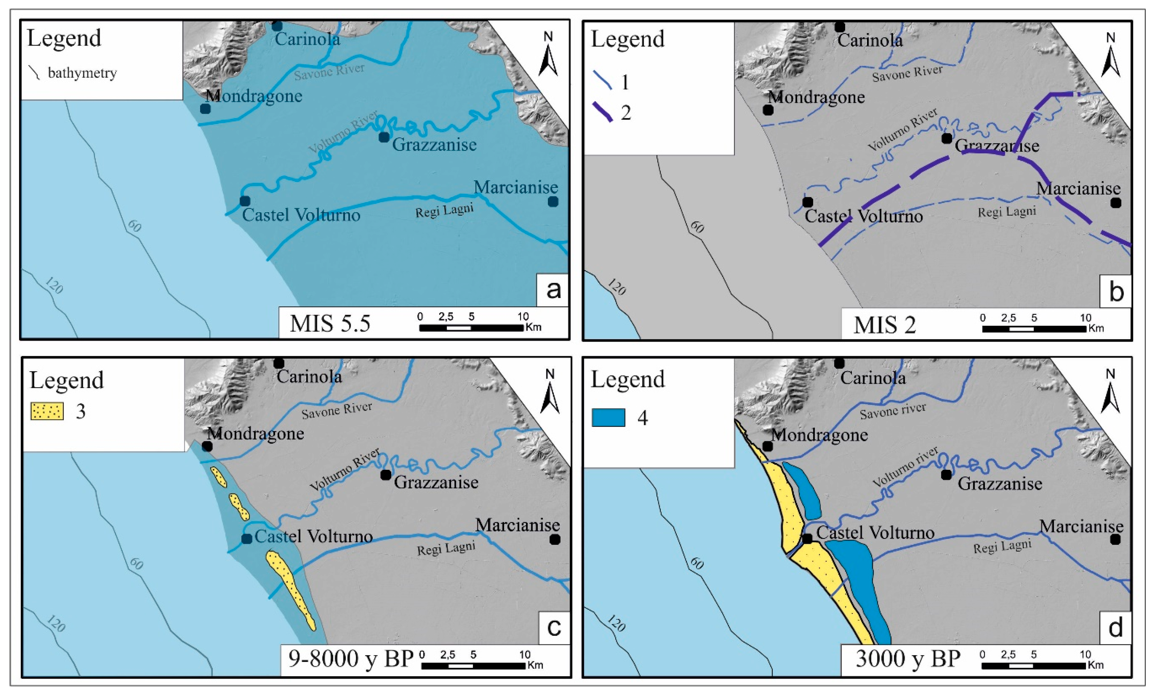
5.4. Geomorphology
6. Discussion and Conclusions
Author Contributions
Funding
Acknowledgments
Conflicts of Interest
References
- Romano, P.; Santo, A.; Voltaggio, M. L’evoluzione geomorfologica della pianura del F. Volturno (Campania) durante il tardo Quaternario (Pleistocene medio-superiore—Olocene). Il Quat. 1994, 7, 41–56. [Google Scholar]
- Barra, D.; Romano, P.; Santo, A.; Campaiola, L.; Roca, V.; Tuniz, C. The Versilian transgression in the Volturno river plain (Campania, Southern Italy): Palaeoenvironmental history and chronological data. Il Quat. 1996, 9, 445–458. [Google Scholar]
- Putignano, M.L.; Ruberti, D.; Tescione, M.; Vigliotti, M. Evoluzione tardo quaternaria del margine casertano della Piana Campana (Italia meridionale). Boll. Soc. Geol. It. 2007, 126, 11–24. [Google Scholar]
- Santangelo, N.; Ciampo, G.; Di Donato, V.; Esposito, P.; Petrosino, P.; Romano, P.; Russo Ermolli, E.; Santo, A.; Toscano, F.; Villa, I. Late Quaternary buried lagoons in the northern Campania plain (Southern Italy): Evolution of a coastal system under the influence of volcano-tectonics and eustatism. Ital. J. Geosci. 2010, 129, 156–175. [Google Scholar]
- Amorosi, A.; Pacifico, A.; Rossi, V.; Ruberti, D. Late Quaternary incision and deposition in an active volcanic setting: The Volturno valley fill, southern Italy. Sediment. Geol. 2012, 242, 307–320. [Google Scholar] [CrossRef]
- Sacchi, M.; Molisso, F.; Pacifico, A.; Vigliotti, M.; Sabbarese, C.; Ruberti, D. Late-Holocene to recent evolution of Lake Patria, South Italy: An example of a coastal lagoon within a Mediterranean delta system. Glob Planet Chang. 2014, 117, 9–27. [Google Scholar] [CrossRef]
- Santangelo, N.; Romano, P.; Ascione, A.; Russo Ermolli, E. Quaternary evolution of the Southern Apennines coastal plains: A review. Geol. Carpath. 2017, 68, 43–56. [Google Scholar] [CrossRef] [Green Version]
- Aiello, G.; Barra, D.; Collina, C.; Piperno, M.; Guidi, A.; Stanislao, C.; Saracino, M.; Donadio, C. Geomorphological and paleoenvironmental evolution in the prehistoric framework of the coastland of Mondragone, southern Italy. Quat. Int. 2018, 493, 70–85. [Google Scholar] [CrossRef]
- Ippolito, F.; Ortolani, F.; Russo, M. Struttura marginale tirrenica dell’Appennino campano: Reinterpretazione di dati di antiche ricerche di idrocarburi. Mem. Soc. Geol. It. 1973, 12, 227–251. [Google Scholar]
- Bernasconi, A.; Bruni, P.; Gorla, L.; Principe, C.; Sbrana, A. Risultati preliminari dell’esplorazione geotermica profonda nell’area vulcanica del Somma-Vesuvio. Rend. Soc. Geol. It. 1981, 4, 237–240. [Google Scholar]
- Milia, A.; Torrente, M.M.; Russo, M.; Zuppetta, A. Tectonics and crustal structure of the Campania continental margin: Relationships with volcanism. Mineral. Petrol. 2003, 79, 33–47. [Google Scholar] [CrossRef]
- Corrado, G.; Amodio, S.; Aucelli, P.P.C.; Incontri, P.; Pappone, G.; Schiattarella, M. Late quaternary geology and morphoevolution of the Volturno coastal plain, southern Italy. Alp. Mediterr. Quat. 2018, 31, 23–26. [Google Scholar]
- Balducci, S.; Vaselli, M.; Verdini, G. Exploration well in Ottaviano permit, Italy, Trecase 1. In Proceedings of the European Geothermal Update 3rd Intern. Sem., Munich, Germany, 29 November–1 December 1983; pp. 407–418. [Google Scholar]
- Brancaccio, L.; Cinque, A.; Romano, P.; Rosskopf, C.; Russo, F.; Santangelo, N.; Santo, A. Geomorphology and neotectonic evolution of a sector of the Tyrrhenian flank of the Southern Apennines (Region of Naples, Italy). Zeit. Geomorph. 1991, 82, 47–58. [Google Scholar]
- Rolandi, G.; Bellucci, F.; Heizler, M.T.; Belkin, H.E.; De Vivo, B. Tectonic controls on the genesis of ignimbrites from the Campania volcanic zone, southern Italy. Mineral. Petrol. 2003, 79, 3–31. [Google Scholar] [CrossRef]
- Ruberti, D.; Sacchi, M.; Pepe, F.; Vigliotti, M. LGM incised valley in a volcanic setting. The northern Campania Plain (Southern Italy). Alp. Mediterr. Quat. 2018, 31, 35–38. [Google Scholar]
- Matano, F.; Sacchi, M.; Vigliotti, M.; Ruberti, D. Subsidence Trends of Volturno River Coastal Plain (Northern Campania, Southern Italy) Inferred by SAR Interferometry Data. Geosciences 2018, 8, 8. [Google Scholar] [CrossRef] [Green Version]
- Iorio, M.; Capretto, G.; Petruccione, E.; Marsella, E.; Aiello, G.; Senatore, M.R. Multi-proxy analysis in defining sedimentary processe in very recent prodelta deposits: The Northern Phlegraean offshore example (Eastern Tyrrhenian Margin). Rend. Fis. Acc. Lincei 2014, 25, 237–254. [Google Scholar] [CrossRef] [Green Version]
- Aiello, G.; Insinga, D.; Iorio, M.; Meo, A.; Senatore, M.R. On the occurrence of the Neapolitan Yellow Tuff tephra in the Northern Phlegraean Fields offshore (Eastern Tyrrhenian margin; Italy). Ital. J. Geosci. 2017, 136, 263–274. [Google Scholar] [CrossRef]
- Misuraca, M.; Budillon, F.; Tonielli, R.; Di Martino, G.; Innangi, S.; Ferraro, L. Coastal Evolution, Hydrothermal Migration Pathways and Soft Deformation along the Campania Continental Shelf (Southern Tyrrhenian Sea): Insights from High-Resolution Seismic Profiles. Geosciences 2018, 8, 121. [Google Scholar] [CrossRef] [Green Version]
- De Vivo, B.; Rolandi, G.; Gans, P.B.; Calvert, A.; Bohrson, W.A.; Spera, F.J.; Belkin, H.E. New constraints on the pyroclastic eruptive history of the Campanian volcanic Plain (Italy). Mineral. Petrol. 2001, 73, 47–65. [Google Scholar] [CrossRef]
- Giaccio, B.; Hajdas, I.; Isaia, R.; Deino, A.; Nomade, S. High-precision 14C and 40Ar/39Ar dating of the Campanian Ignimbrite (Y-5) reconciles the time-scales of climatic-cultural processes at 40 ka. Sci. Rep. 2017, 7, 45940. [Google Scholar] [CrossRef] [Green Version]
- Ortolani, F.; Aprile, F. Principali caratteristiche stratigrafiche e strutturali dei depositi superficiali della Piana Campana. Boll. Soc. Geol. It. 1985, 104, 195–206. [Google Scholar]
- Deino, A.L.; Orsi, G.; De Vita, S.; Piochi, M. The age of the Neapolitan Yellow caldera-forming eruption (Campi Flegrei caldera—Italy) assessed by 40Ar/39Ar dating method. J. Volcanol. Geotherm. Res. 2004, 133, 157–170. [Google Scholar] [CrossRef]
- Giordano, G.; Naso, G.; Trigari, A. Evoluzione tettonica di un settore particolare del margine tirrenico: L’area al confine tra Lazio e Campania. Prime considerazioni. Stud. Geol. Camerti 1995, 2, 269–278. [Google Scholar]
- Billi, A.; Bosi, V.; De Meo, A. Caratterizzazione strutturale del rilievo del M. Massico nell’ambito dell’evoluzione quaternaria delle depressioni costiere dei Fiumi Garigliano e Volturno (Campania settentrionale). Il Quat. 1997, 10, 15–26. [Google Scholar]
- Di Lorenzo, H.; Corrado, G.; Aucelli, P.; De Iorio, M.; Schiattarella, M.; Russo Ermolli, E. Environmental evolution and anthropogenic forcing in the Garigliano coastal plain (Italy) during the Holocene. Holocene 2020, in press. [Google Scholar]
- Aucelli, C.P.P.; Di Paola, G.; Incontri, P.; Rizzo, A.; Vilardo, G.; Benassai, G.; Buonocore, B.; Pappone, G. Coastal inundation risk assessment due to subsidence and sea level rise in a Mediterranean alluvial plain (Volturno coastal plain, southern Italy). Estuar. Coast. Shelf Sci. 2017, 198, 597–609. [Google Scholar] [CrossRef]


| Unit | Description | References | Chronology (Age BP) | Depositional Environment |
|---|---|---|---|---|
| U1p | Grey silty clays and silt with local sandy intercalations. Small mollusc shells (euryhaline fauna) are common. Thickness range: few metres—6 m. Transitional boundary with U1d. This unit is only located to coastal sector. | [5] | Holocene (0–12 ky) | Pro-delta |
| U1d | Well sorted, medium to coarse grey or yellowish sands, with abundant marine shells fragments, plant and rare pumice fragments. A general coarsening-upward trend occurs. Thickness range: few meters–16 m. Basal erosional contact with U2 and U4. Transitional boundaries with U1m landward and U1p seaward. | Holocene (0–12 ky) | Shoreface-beach-dune-ridge complex | |
| U1m | Grey to dark grey clays with abundant organic matter and freshwater gastropods. Peat intercalations and sandy layers with mollusc and pumice fragments occur at places (Radiometric age from lower part of swamp/lagoonal deposits: 8–12 ky). Thickness range: few meters—30 m. Lower erosive boundary with U2, U3 and U4. Transitional boundaries with U1a landward and U1d seaward. | [5] | Holocene (0–12 ky) | Back-dune ridge complex Lagoon/estuary, coastal plain/swamp |
| U1a | Rooted and pedogenized, brown to grey clays and silty clays with abundant whitish pumices and plant fragments. Gravel with sand lens locally occurs. Thickness range: few meters—35 m. Lower erosive boundary with U2 and U3 and transitional contact with U1m seaward. | Holocene (0–12 ky) | Alluvial plain | |
| U2 | Two distinct events form this unit: Giugliano Ignimbrite (GI) and Neapolitan Yellow Tuff (NYT). The GI is pyroclastic flow deposit (23–18 ky), separated by paleo-sols from Campania Ignimbrite (CI) below and the incoherent NYT fall deposits above. The NYT consists of alternations of pumice and ash beds (Pozzolana), zeolitized yellow tuff, volcanic sands, cinerite deposits, sometimes reworked by fluvial erosion. Thickness range: few meters—30 m. Basal erosional contact with U3 and U4 and upper erosive boundary with U1. | [15,21] | Late Pleist. Holocene (12–23 ky) | Continental (volcaniclastics) |
| U3 | Gravels and sands deposited as lens-shape bodies and characterized by upward transition to silty clays or silts with local peat intercalations (radiometric age 37 ky BP). White pumices and lapilli as well as pedogenized horizons locally occur. Thickness range: few metres—20 m. Lower erosional contact with U4 and U5; cover is represented by U1 and U2. | [5] | Late Pleist. (23?–37 ky) | Alluvial plain |
| U4 | CI is a laterally continuous body formed by a pyroclastic flow, consisting of coherent (breccia Piperno) to totally incoherent (Cinerazzo) reddish or grey tuffs, with sandy scoriae, pumices and lithic elements. Thickness range: few metres—40 m. CI rests on coastal marine (U5) seaward and on the pre-CI volcaniclastic (U6) unit landward. The U1 and U2 units cover it by erosional contact. | [22] | Late Pleist. (about 40 ky) | Continental (volcaniclastic) |
| U5 | Yellowish and grey sands with mollusc shells, clays with local peat lens. Intercalations of gravels, pyroclastic and travertine deposits also occur. Thickness range: 20 to >50 m. Upper (U4 and U3) and lower (U6) erosional contacts are present. | Late Pleist. (40?–50 ky) | Coastal-marine, transitional with continental episodes | |
| U6 | Pre-CI pyroclastic deposits produced by different eruptions from Roccamonfina (youngest events) and Phlegraean Fields (oldest events), locally separated by thin paleo-sols. Tuffs, pozzolana, lapilli and cinerite; rare lavas and clay lens. Thickness range: 5 to >60 m. The U6 rests on U7 by erosional contact and is covered by the U4 and U5. Radiometric age at the base 105 ka. | [4] | Late Pleist. (50–105 ky) | Continental (volcaniclastic) |
| U7 | Fossiliferous clays and silts interbedded with yellow sands or fine gravels (Radiometric age 126 ky;). Thickness range: 30 to >50 m. The U7 could be in contact at the base with the carbonate substrate and it is covered by the U6. | [1] | Late Pleist. (105–130 ky) | Coastal-marine, transitional |
Publisher’s Note: MDPI stays neutral with regard to jurisdictional claims in published maps and institutional affiliations. |
© 2020 by the authors. Licensee MDPI, Basel, Switzerland. This article is an open access article distributed under the terms and conditions of the Creative Commons Attribution (CC BY) license (http://creativecommons.org/licenses/by/4.0/).
Share and Cite
Corrado, G.; Amodio, S.; Aucelli, P.P.C.; Pappone, G.; Schiattarella, M. The Subsurface Geology and Landscape Evolution of the Volturno Coastal Plain, Italy: Interplay between Tectonics and Sea-Level Changes during the Quaternary. Water 2020, 12, 3386. https://doi.org/10.3390/w12123386
Corrado G, Amodio S, Aucelli PPC, Pappone G, Schiattarella M. The Subsurface Geology and Landscape Evolution of the Volturno Coastal Plain, Italy: Interplay between Tectonics and Sea-Level Changes during the Quaternary. Water. 2020; 12(12):3386. https://doi.org/10.3390/w12123386
Chicago/Turabian StyleCorrado, Giuseppe, Sabrina Amodio, Pietro P. C. Aucelli, Gerardo Pappone, and Marcello Schiattarella. 2020. "The Subsurface Geology and Landscape Evolution of the Volturno Coastal Plain, Italy: Interplay between Tectonics and Sea-Level Changes during the Quaternary" Water 12, no. 12: 3386. https://doi.org/10.3390/w12123386
APA StyleCorrado, G., Amodio, S., Aucelli, P. P. C., Pappone, G., & Schiattarella, M. (2020). The Subsurface Geology and Landscape Evolution of the Volturno Coastal Plain, Italy: Interplay between Tectonics and Sea-Level Changes during the Quaternary. Water, 12(12), 3386. https://doi.org/10.3390/w12123386