Review

In-Channel Managed Aquifer Recharge: A Review of Current Development Worldwide and Future Potential in Europe

by
Kathleen Standen
*,
Luís R. D. Costa
and
José-Paulo Monteiro
Centro de Ciências e Tecnologias da Água (CTA), Universidade do Algarve, CERIS, IST, 8005-139 Faro, Portugal
*
Author to whom correspondence should be addressed.
Water 2020, 12(11), 3099; https://doi.org/10.3390/w12113099
Submission received: 29 September 2020 / Revised: 23 October 2020 / Accepted: 29 October 2020 / Published: 4 November 2020

Abstract

:
Managed aquifer recharge (MAR) schemes often employ in-channel modifications to capture flow from ephemeral streams, and increase recharge to the underlying aquifer. This review collates data from 79 recharge dams across the world and presents a reanalysis of their properties and success factors, with the intent of assessing the potential of applying these techniques in Europe. This review also presents a narrative review of sand storage dams, and other in-channel modifications, such as natural flood management measures, which contribute to the retardation of the flow of flood water and enhance recharge. The review concludes that in-channel MAR solutions can increase water availability and improve groundwater quality to solve problems affecting aquifers in hydraulic connection with temporary streams in Europe, based on experiences in other parts of the world. Therefore, to meet the requirements of the Water Framework Directive (WFD), in-channel MAR can be considered as a measure to mitigate groundwater problems including saline intrusion, remediating groundwater deficits, or solving aquifer water quality issues.

1. Introduction

Managed aquifer recharge (MAR) includes a suite of methods to enhance aquifer recharge that are increasingly used to maintain, enhance, and secure groundwater systems under stress [1]. MAR schemes are able to bridge the discrepancy between the timing of additional water availability, generally during the winter, with the timing of peak demand during the growing season for irrigation, and during the summer for domestic uses.
There are a number of drivers resulting in the increased use of MAR in Europe. Climate change is a major driver for adaptation and resilience measures to protect water supplies [2]. There has already been decrease in runoff of 15 to >20% during the driest month in parts of southern Europe between 1951 and 2015 [3,4] driven by changes in rainfall frequency and duration. Meanwhile, annual river floods have increased in northwestern Europe over the period 1960–2010 and flash floods triggered by intense local precipitation are likely to become more frequent due to climate change [5]. This has led to increasing awareness and implementation of nature-based solutions (NBS) including natural flood management (NFM) measures aiming to reduce the flood peak discharge and increase the lag time by restoring more natural land cover and channel-floodplain features [6].
In Europe, the Water Framework Directive (WFD) requires EU member states to achieve “Good” status for all groundwater and surface water bodies by 2027. This provides a major driver for MAR schemes as a measure to achieve good groundwater quantity and quality status. For example, in Portugal, a combination of MAR measures are proposed for this purpose, including rainwater harvesting, check dams, and in-channel infiltration basins to reduce nitrate concentrations and hence improve groundwater quality in the Campina de Faro aquifer [7].
These drivers together have led to an increase in the uptake of MAR, both globally and in Europe [1,8], with the main MAR method in Europe being river bank filtration, supplemented from the 1970s by the increased use of well injection [8]. The International Groundwater Resources Assessment Centre (IGRAC) MAR portal lists only two schemes recorded as in-channel modifications: a recharge dam in France, and a subsurface dam in Italy [9]. The IGRAC portal includes the records of 286 European MAR schemes identified as part of the earlier project [10].
As the options for defining new water supply sources are limited, defining new origins for drinking water supply and for irrigation becomes more problematic and expensive, particularly in Southern Europe, and large multimunicipal options, such as reuse of treated wastewater for irrigation, desalinization of seawater, construction of new surface water dams, and even direct abstraction in rivers already failing to meet “Good” status are being planned and implemented, e.g., [11]. The purpose of this paper is to show how in-channel MAR solutions capturing floodwater from ephemeral streams are an important technique to remedy, or at least improve, quality, and quantity issues affecting aquifers in hydraulic connection with temporary streams in Europe, based on the performance of a large number schemes in other parts of the world. Whilst several previous reviews collate information on a global or regional scale, none have been identified that examine in-channel MAR in detail [1,9,12]. This review collates and analyzes information on constructed in-channel MAR schemes, identifying their characteristics, hydrogeology and water balance, and recharge effectiveness, and identifies the opportunity for their further applicability in Europe as a tool to mitigate problems related with local-scale degradation of groundwater as saline intrusion, remediating groundwater deficits, or solving aquifer water quality issues by in-channel storage solutions.
The main contribution of this study, regarding the benefit for the readers, consists in the potential contribution of in-channel MAR to capture and store floodwater to complement water resources management at regional scale. Currently, a similar trend towards more local solutions can be identified also in relation with the production of electric energy using natural (local scale) hydric systems to complement (or even substitute) large-scale solutions as reported for [13]. In fact, it is interesting that local-scale solutions for water supply and irrigation were mostly abandoned in much of Europe in the second half of the 20th century but were often used centuries ago in all the Mediterranean area (e.g., [14]), and could eventually form the basis of the recuperation of local areas of degraded groundwater bodies in Europe’s future.
The review is structured as follows:
  • Section 2 details the types of in-channel MAR features included in the review, their main characteristics, and modes of recharge.
  • Section 3 describes the review methodology and information sources.
  • Section 4 describes recharge dam occurrence, site selection, hydrogeology and water balance, characteristics and effectiveness, and the recharge benefits. This section includes a systematic review of 79 recharge dams identified in the literature.
  • Section 5 describes sand storage dam occurrence, site selection, hydrogeology and water balance, characteristics and effectiveness. This section is a narrative review of sand storage dams mainly found in Africa.
  • Section 6 describes other in-channel modifications including in-channel infiltration basins, but also includes natural flood management (NFM) measures and the natural actions of beavers and their contribution to increasing recharge.
  • Section 7 identifies the applicability and potential for these techniques to be developed in Europe.
  • Section 8 describes the main conclusions and recommendations.

2. Types of In-Channel Modification

This review uses the following definitions for in-channel modifications for MAR, as defined by the MAR portal [15], and further refined to identify different types of recharge dams:
  • Sand storage dams are constructed aboveground in intermittent streams, trapping sediment behind the dam, so that future runoff infiltrates, creating an artificial aquifer upstream of the dam. They are usually of earthen, stone, or concrete construction, and are common in parts of Africa and China.
  • Recharge/check dams, including:
    • Wadi-recharge dam structures to intercept runoff during flash floods in wadi environments, typically with controlled release downstream where most of the recharge occurs.
    • Rubber dams across relatively large rivers. These flexible elliptical structures are made of rubberized material and attached to a concrete base, inflated by air/water, and deflated as necessary to flush out sediments and prevent damage during extreme floods. For MAR, these appear to be mainly used in China, and are commonly used in California.
    • Small dam structures across small streams, often of earthen, concrete, or gabion construction, are particularly common in India where they are known as check dams, nalah bunds, anicuts, or johads.
    • Erosion/sediment control dams, generally in mountainous areas with large catchment slopes, which may also enhance recharge. Once full of sediment, these could be considered sand storage dams.
    • Debris or leaky dams, which form either naturally or by the natural activities of beavers, or are constructed as part of “natural flood management” measures, or river restoration activities that slow river flow and enhance recharge.
  • Channel spreading techniques, which increase the wetted area and infiltration rate of the streambed by widening, leveling, scarifying, dredging, and the use of L-shaped levees.
Subsurface dams are not included in this review as they are composed of a cutoff wall to dam groundwater flow, raising the height of groundwater upgradient of an underground dam. Therefore whilst they can provide significant benefits in terms of mitigating saline intrusion or increasing regional groundwater levels, they are not usually installed in river channels. Further details can be found in an existing review paper [16].
The method of recharge for the in-channel MAR methods is shown in Figure 1. Figure 1a shows a typical recharge dam where recharge occurs through the base of the pond, and downwards to the underlying aquifer. Ideally the groundwater levels will be below the base of the pond at all times of year such that the recharge occurs vertically downwards to the groundwater table, where it forms a mound. The most effective recharge dams have silt removal mechanisms to allow release of silt to maintain the infiltration rate. Wadi-recharge dams are shown in Figure 1b, with the only difference from Figure 1a being that water is stored in the dam and released over several days/weeks so it can gradually infiltrate through the riverbed downstream. Figure 1c shows a sand storage dam, where the recharge occurs either by direct rainfall onto the accumulated sediment, or by infiltration of runoff that flows over/into the sediments. Figure 1d shows a type of in-channel infiltration basin, where low permeability riverbed sediments have been removed and replaced with gravel infill, which provides a pathway for recharge to occur from the river into the underlying permeable aquifer.
River water is usually the source of water for in-channel MAR, usually where river flow is ephemeral, or at least exhibits substantial seasonal variability in flow. In other MAR schemes where river water is the source for MAR, e.g., spreading methods/infiltration basins, in-channel modifications, such as a dam or control structure, it is usually necessary to route the water to the MAR scheme, particularly where these are gravity fed. For these schemes, the aim is not to induce recharge due to the in-channel structure, although this can be a side-benefit, as occurred at the El Carracillo in-channel MAR structure [17].

3. Methodology

Case studies were collected from academic papers, theses, conference proceedings and internal reports published in English, Spanish, or Portuguese. A major source of information was the IGRAC MAR portal, where the Global MAR Inventory Working Group consolidated information on 1200 MAR projects [9] and papers based on reviews of this information, e.g., [12,18].
A search for the topic “Check Dam” in the Web of Science database found 1365 hits, whilst “Recharge Dam” found 591 hits, indicating a relative scarcity of published literature on these MAR structures. The search term “Check Dam” included many papers where the focus was sediment and erosion control rather than MAR structures. The top 10 countries publishing on this topic were China (335), USA (170), India (162), Spain (121), Italy (96), Japan (68), Iran (61), France (60), Taiwan (48), and England (42) [19].
From these sources, relevant literature was selected such that a detailed review of recharge dam characteristics could be completed. Data were collated from 16 papers, relating to the characteristics of 79 recharge dams, mainly located in India (52), Spain (13), Jordan (6) China (4), Saudi Arabia (2), Cyprus (1), and Oman (1) [20,21,22,23,24,25,26,27,28,29,30,31,32,33,34]. The analysis included recharge dams, check dams for sediment control, wadi-recharge dams, and rubber dams. The inclusion criteria were that information from individual recharge dams was available (not combined for several structures), and as a minimum, values for dam storage capacity and estimated annual recharge were available, as the dam storage capacity is one of the main factors controlling the recharge volumes. Data on other factors controlling the recharge were captured, including annual rainfall, runoff and flow duration, infiltration rates, and geological setting, where available. Only those MAR schemes that were constructed were included, therefore excluding proposed schemes even where significant modeling had been undertaken, e.g., [35,36]. If multiple management scenarios were implemented [34], these were included, bringing the total number of data points up to 86.
Recharge to the underlying aquifer is not usually the main aim at sand storage dams; hence these were excluded from the systematic review and described separately in Section 5.

4. Recharge Dams

4.1. Occurrence

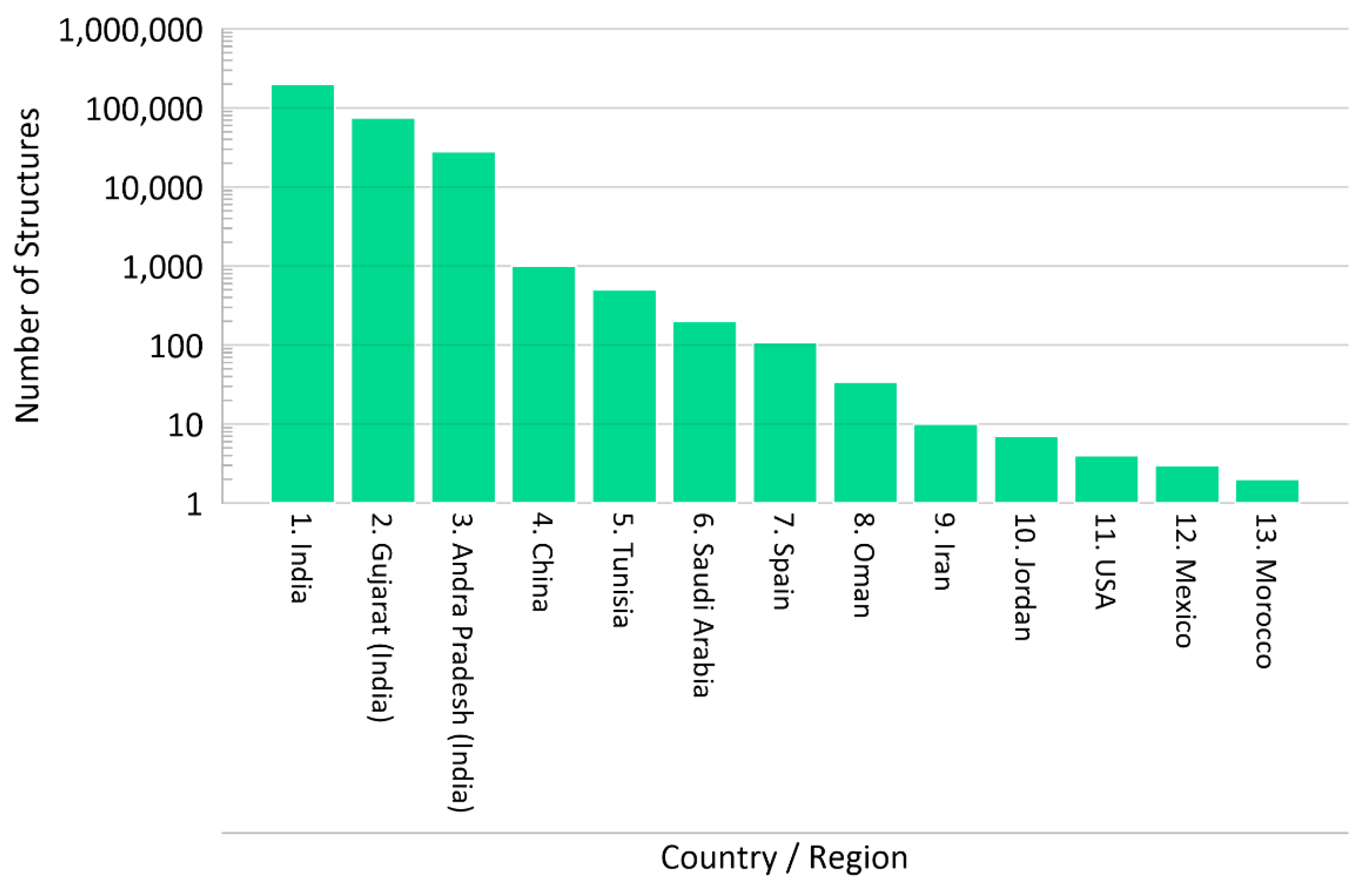
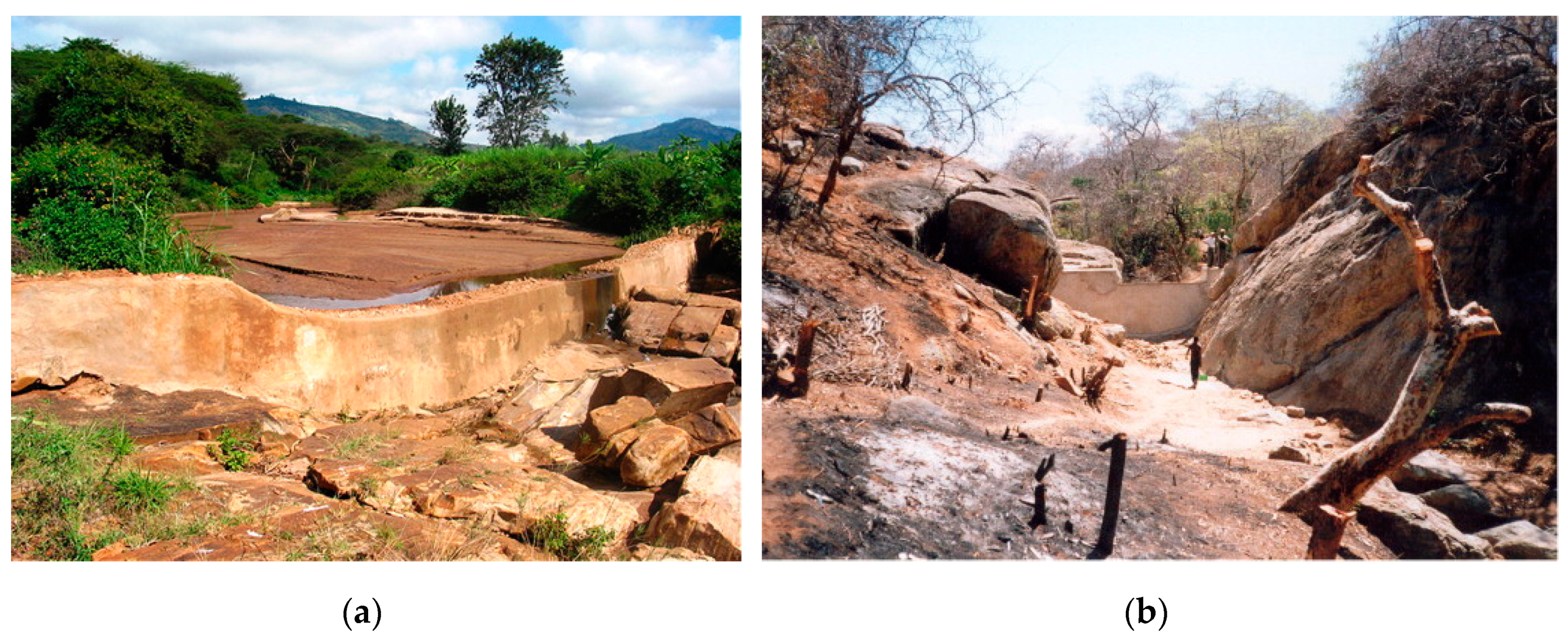
A review of the IGRAC MAR Portal and the literature identified approximate numbers of recharge dams by each country/region, which are summarized in in Figure 2, based on data from [9,18,20,25,28,29,33,37,38], with photographs of recharge dams shown in Figure 3 [23,38] that represent different construction methods. It is likely that these numbers are significantly underestimated, as these are small structures not frequently studied or reported in scientific literature. The MAR Portal is not reflective of the large total numbers shown in Figure 2, as the inclusion criteria for the MAR portal required a specific location for each structure to be available [9].
As this section includes recharge dams of the types shown in Figure 1a,b, a diverse range of dam sizes and types are encountered. They are most frequent in India, where more than 200,000 recharge dams have been constructed (Figure 2). In Tunisia, small earthen reservoirs for both irrigation and artificial recharge were constructed by the government [39]. In Oman, large wadi-recharge dams were designed to mitigate saline intrusion [22]. Finally, in China, rubber dams are often built to manage monsoon flood runoff and to maintain river flows during the dry season for recreational or aesthetic purposes, but they have also been constructed specifically for groundwater recharge to mitigate saline intrusion or remediate groundwater deficits, often in cascades of several dams [20,40].
Small recharge dams are ubiquitous in India to enhance groundwater recharge to sustain irrigation water supplies. Significant further construction of recharge dams is envisaged by the 2013 Master Plan, where 11 million artificial recharge structures were proposed [37].

4.2. Site Selection

Methods of site selection for MAR schemes have focused on large-scale GIS-based and multicriteria decision analysis methods to identify suitable areas within a large region [41,42]. However, uncertainties are often not well accounted for in GIS-based methods, and information can be lost [43]. For location and design of a recharge dam, it is important to consider the physiography, geology, hydrology, hydrogeology, hydrochemistry, sediment load, and infiltration capacity on a site-specific basis [44]. During this review, the following broad criteria were identified:
  • The recharge dam needs to be upstream/upgradient from where the recharged water is required, and close enough to this location that the additional recharge can be captured/used.
  • Groundwater levels need to be sufficiently below the base of the stream at the time of year when recharge occurs, and more regionally, sufficient unsaturated zone thickness is needed to accept the additional recharge without causing unacceptable groundwater level rise and consequent flooding of land or damage to structures.
  • The underlying strata should have sufficient permeability, such that the water held in the dam can be recharged at a sufficient rate (before the water is evaporated); i.e., low permeability alluvial deposits should not be present or should be removed during construction.
  • The storage volume and retention time of the structure needs to be matched to the catchment inflow, such that sufficient volumes are recharged, balanced by the cost of providing increased storage due to increased dam size. Typically, the storage is small in comparison to peak flows, so only a small proportion of flow is captured during these events.
The most comprehensive and specific guidance on the design and construction of recharge dams (including gully plugs, nalah bunds, and check dams) for MAR is from India, indicating that a total catchment 40 to 100 ha should be selected, with rainfall <1000 mm/year, the width of stream bed 5–15 m, the depth of stream bed >1 m, the dam height normally less than 2 m, and the land downstream of check dam/nalah bund under well irrigation [45]. To harness the maximum runoff along a stream, a series or cascade of structures is required for recharge to be effective on a regional scale [45]. These criteria were developed based on significant country specific experience, but do not necessarily translate to other areas or situations and may not be suitable in wadi regions, for example.
River water quality and sediment load also need to be considered in the selection of suitable locations, i.e., avoiding areas with industrial discharges to rivers, and considering the sediment input into the dam and how this can be managed to avoid reductions in infiltration rates. Social considerations such as assessing where water is needed, and the cost–benefit of any proposed structure are also important [45].

4.3. Hydrogeology and Water Balance

Methods for estimating the recharge occurring beneath a recharge dam include:
  • Water balance method by measuring inputs and outputs from the dam and inferring recharge [30,46];
  • Water table fluctuation (WTF) method using nearby groundwater level measurements [28,31,46];
  • Stable isotopes to identify different water qualities between native groundwater and water recharged by the MAR structure to infer proportions and hence recharge volumes [24,38,47];
  • Chloride mass balance to estimate recharge where there is a significant difference in chloride concentrations between native groundwater and recharge water [28,48];
  • Direct site investigation methods to estimate infiltration rates, e.g., the Haefili method or double-ring infiltrometer tests [33] or tension infiltrometers [49]; and
  • Indirect methods, using vertical profiles of temperature time series measurements to estimate river flow duration and infiltration [50].
These methods are often combined with numerical modeling to understand the impacts spatially and over time [51,52]. When methods are compared, for a recharge structure near Hyderabad, India, the recharge using a chloride mass balance approach, was 30–35% of the dam volume compared to 50% when estimated with the water balance method [48], whilst there was good agreement between recharge estimated with the WTF method and the chloride mass balance method (7.3–9.7% vs. 7.5% of annual rainfall) for a check dam in Gujarat, India [28].
There will be differences in recharge estimates depending on the methods used and a combination of methods may identify a range of recharge estimates. One important limitation was identified in that measuring water loss from the dam (even after accounting for evaporation) does not necessarily equal the recharge reaching groundwater, especially when the unsaturated zone has a large thickness [53]. For example, at the Sidi Saad dam in Tunisia (capacity 154 hm3, annual release for infiltration 0–163 hm3/year) it was shown that most of the released water was lost to evaporation or nonbeneficial vegetation growth rather than to aquifer recharge through the riverbed [47]. This is often the case for recharge through ephemeral streams where transmission losses are usually much higher than recharge [54].
The water balance method requires estimates of inflow, overflow, dam storage, and evaporation loss over time in order to estimate the recharge. Where river gauging is not available, estimating surface water inflow to a recharge dam can be achieved with one of several rainfall–runoff models ranging from simple to more complex, all of which transform catchment rainfall data to an estimate of runoff into the recharge dam, for example, the Australian Water Balance Model (AWBM) [55], the Surface Water Management Model (SWMM) [56], or the Soil Water Accounting Tool model (SWAT) [57].

4.4. Recharge Dam Characteristics

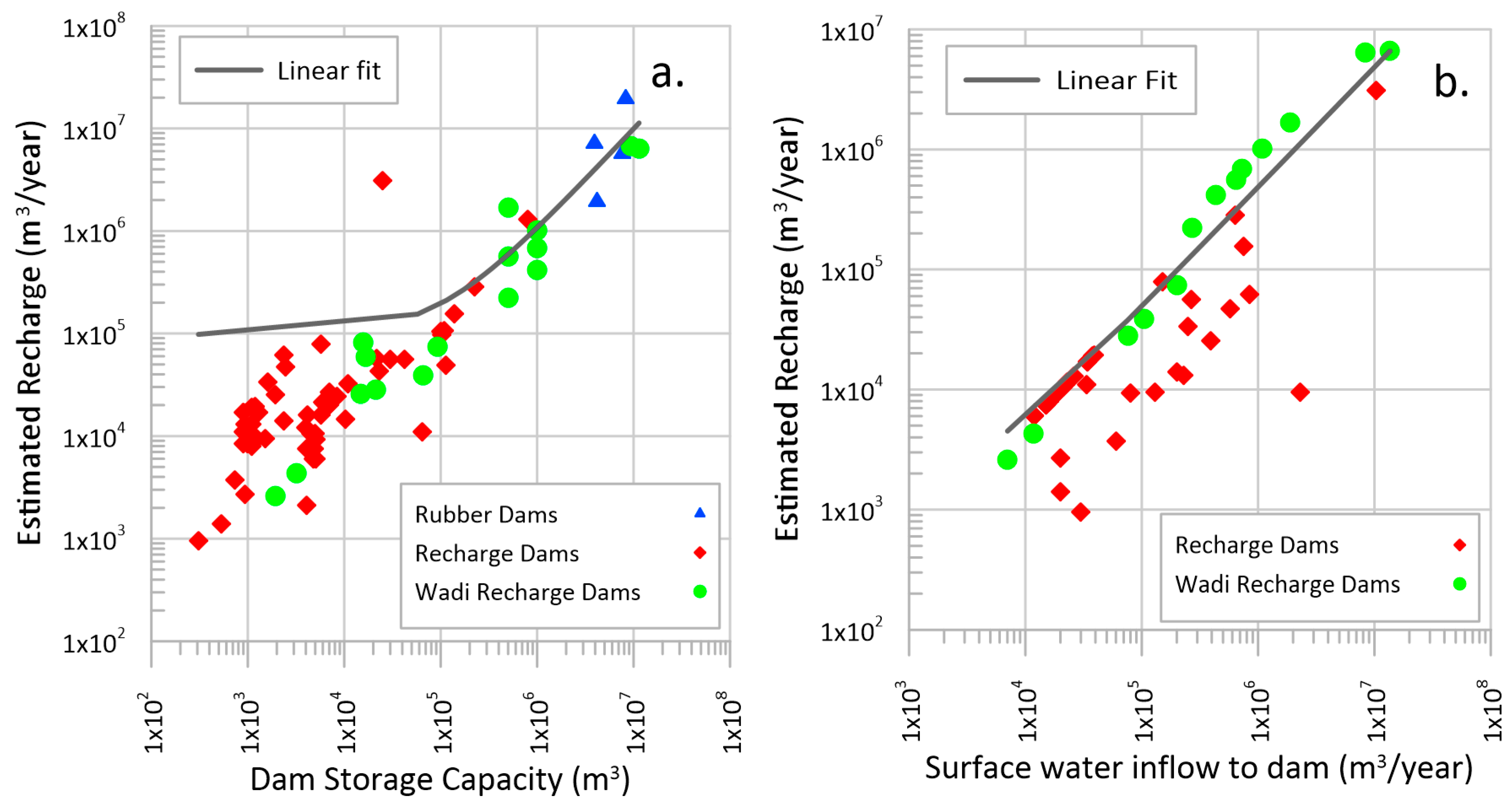
In the compiled data (presented in Supplementary Materials: Appendix 1), dam storage capacities span almost five orders of magnitude, from hundreds of m3 to greater than 10 hm3, whereas the recharge dams’ storage capacity are usually between 1000 and 100,000 m3 in size. Wadi recharge dams can be considerably larger, and the rubber dams in China, even larger. The relationship between dam storage capacity and estimated annual recharge occurring as a result of the dam is shown in a double log plot (Figure 4a). A positive relationship is obtained (using data from all types of recharge dams) with an R2 = 0.64 and R = 0.80 based on a linear fit. As expected, dam storage capacity alone cannot account for all the variability in recharge rate, hence the low R2 value. The majority of recharge dams are able to recharge an annual volume greater than their storage capacity, particularly where storage is between 1000 and 10,000 m3, where a large number of recharge dams are able to recharge 10,000 m3 to 100,000 m3/year. However, as dam capacity gets larger, the annual recharge is likely to be closer to the capacity, or slightly below this figure. It is expected this could be a function of the event for which the dams are designed. For example, although the hydrology of wadi environments varies considerably, wadi recharge dams are often designed for both flood control and aquifer recharge, and therefore capture a high-intensity, higher return period event (e.g., dams spilling during a 1-in-2-year to 1-in-5-year return period event [23]) compared to the smaller check dams of India, which fill three or four times a year [32]. Therefore, the storage volume will be larger, but will fill less frequently, resulting in a lower ratio between storage capacity and recharge.
For the check dams in Almería, it was possible to define two clear linear relationships between storage capacity and induced recharge for two geologies with very different permeabilities (limestone and calcoschist) [33], with the slope of the line in this case being related only to the hydraulic conductivity, as the data were based on the same design rainfall event. For the majority of the recharge dams reported here, the recharge was estimated annually, with the exception of the check dams in Almería, where recharge was estimated based on a 1-in-5-year return period 6-hr storm event rather than an annual total [33].
Annual surface water inflow is plotted against estimated annual recharge in Figure 4b (no data on annual runoff available for the rubber dams). Visually, the figure shows that for the same annual runoff, wadi dams appear to have a greater annual recharge than other recharge dams. An overall line of best fit was calculated (R2 = 0.87, R = 0.93) for all types of recharge dams. As for dam storage capacity, annual surface water inflow alone cannot account for the variability in recharge rate, due to the importance of saturated and unsaturated zone flow processes beneath the recharge dams, and their dependence on head gradients and vertical hydraulic conductivity.
Table 1 presents statistics for all recharge dams presented in the 16 sources cited previously. Annual average rainfall ranges from 115 to 1860 mm/year, even though there is some guidance [45] that suggests additional recharge should not be necessary in situations where rainfall is greater than 1000 mm/year. Interestingly, the case study with the highest rainfall (1860 mm/year) was in the Kolwan valley (India). There, it was found that two of the three check dams were gaining water from groundwater rather than replenishing the aquifer, and although the third did recharge groundwater, the recharged water would emerge in the river channel further downstream [26,27], therefore check dams in this area were not supporting aquifer recharge significantly. This also occurred where recharge dams were located on second order streams in the Dharta watershed (India), where during years of higher rainfall, recharge was reduced as groundwater levels rose and became hydraulically connected to the recharge dams [58]. When designing recharge dams, it should be noted that although the 75th percentile height is only 5.0 m, higher dam heights of 19–25 m in Pakistan have been reported [59].

4.5. Recharge Effectiveness

4.5.1. Measures of Recharge Effectiveness

Two measures are considered to measure the effectiveness of recharge dams:
  • Recharge efficiency (RE), defined and used by [31,33,58] as the estimated annual recharge through the structure divided by the dam storage capacity, and
  • Runoff collection efficiency (RCE), defined as the dam storage capacity divided by the annual captured runoff volume.
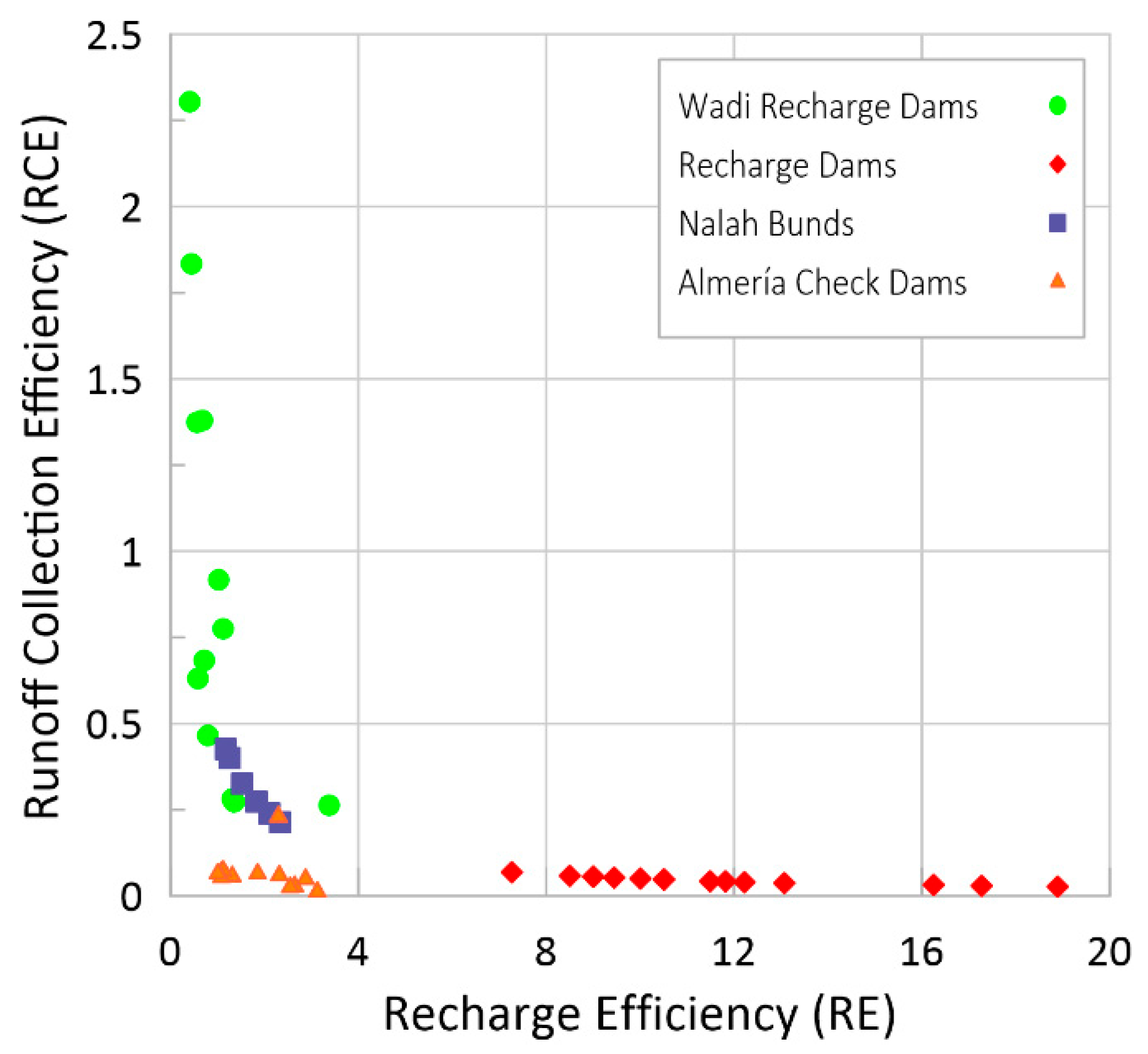
RE is a measure of how effective the structure is and allows identification of recharge dams that are more effective per m3 of storage in terms of the recharge that occurs. Values of RE were calculated for all recharge dams in the literature where storage capacity and a recharge estimate was available (Table 2). Some of the small dams have extremely high effectiveness, with small capacity dams being responsible for recharge of up to 125 times the storage capacity. In Almería, the check dams overlying highly permeable strata (limestones and dolomites) had RE values range from two to four. Meanwhile, for the check dams overlying lower hydraulic conductivity strata (calcoschists), the RE is almost one [33].
Runoff collection efficiency (RCE) was defined by the authors, since it does not appear to have been previously defined in the literature reviewed, but is a useful measure to describe the proportion of runoff collected. Where the runoff collection efficiency is less than one, the dam storage capacity is less than the annual runoff. This is usually the case, except for some wadi recharge dams where the interannual rainfall variability is substantial and the dams are often designed for an event that does not occur every year. For example, most of the dams at Wadi Madoneh were designed to capture the 1-in-2-year rainfall event without spilling, with one dam designed for the 1-in-5-year rainfall event [23]. For smaller dams, a value higher than one may indicate an inappropriately large dam for the runoff available, although interannual runoff is typically variable in ephemeral catchments, and therefore RE and RCE may vary considerably each year.
RE is plotted against RCE in Figure 5 where both measures could be calculated. Both RE and RCE are dependent on the provided estimates of recharge presented in the literature, and it should be noted that recharge can be calculated using several different methods (see Section 4.3), which introduces additional uncertainty to this analysis. Wadi dams generally have a higher RCE than other recharge dams, but their RE values are the same as many check dams and nalah bunds, and lower than some check dams. The higher RCE is a reflection of hydrological situation with fewer, higher intensity rainfall events, and the comparatively larger storage capacities can intercept a greater proportion of the runoff. The low frequency of these events is thought to result in the low RE values. In Jordan, four check dams in the Wadi Madoneh were constructed with capacities from 2000 to 66,400 m3, and three of these were designed to capture flows up to the 1-in-2-year event, with one dam capturing up to the 1-in-5-year event. In conclusion, Figure 5 shows that collecting a higher proportion of runoff (higher RCE) does not necessarily increase the recharge effectiveness (RE value), and therefore where MAR is the main aim, then smaller, less expensive structures that capture a lower proportion of the runoff may be more effective per m3 of storage provided.
Even within the smaller structures, there appears to be a difference between nalah bunds and check dams, probably relating to their position in the catchments, with nalah bunds having higher RCE values, indicating they capture a larger proportion of the annual runoff, and are often located higher up the catchment on streams of lower order than check dams.
Interestingly for each type of structure, there appears to be a negative correlation between RCE and RE. The amount of recharge through a recharge dam is affected by a number of factors, but one of the most important appears to be the percentage of time that the structure holds water, as these are all located on ephemeral watercourses. Structures that have higher RE may tend to experience longer periods of time where the dam is full, allowing recharge to occur over a longer period, but these will tend to collect a lower proportion of the annual runoff, as once the structure is full, any further runoff will be lost downstream.
One of the main controlling factors of recharge through check dams is the hydraulic conductivity of the underlying aquifer, and any deposited sediments. However, the infiltration rates or saturated hydraulic conductivity (Ks) values are rarely reported. A number of sites in India report infiltration rates in the range of 12–78 mm/day [26,30,31], which is relatively low, reflecting the hard rock terrain, and limited weathered zone aquifers that these check dams intersect, with the recharge rates owing to the length of time that water is stored in the dams (often around 5 months [26]). Infiltration rates beneath some wadi dams, and certainly downstream of the dams are likely to be higher, based on the saturated hydraulic conductivity measurements from Al Khoud dam (Ks up to 8 m/day) [49]. A review of MAR sites in Africa identified that they were much more likely to be situated in sedimentary rocks, with schemes located in Egypt, Ethiopia, Morocco, South Africa, and Tunisia [18].
In Almería, of the 107 check dam structures, only 64 were considered to promote infiltration of water retained, as these were located on permeable strata (limestones, dolomites and calcoschists compared to impermeable phyllites) [33].

4.5.2. Local Impacts

Recharge dam benefits have been divided into “local” and “regional”, where “regional” refers to aquifer scale; i.e., a benefit must be significant in relation to the whole aquifer or groundwater management unit, whilst “local” benefits a small number groundwater users over a small geographical area (sub km scale).
Local benefits usually result from an increase in groundwater levels close to a recharge dam, leading to increased well yields and associated agricultural production, supporting more water intensive crops, and/or increasing crop yields, as well as potential water quality benefits. A summary of the typical local impacts are presented below. These examples are largely in the hard rock terrains of India and Pakistan, where a weathered zone aquifer often exists and is used to support irrigation.
At a check dam in India (CD3, Kolwan Valley), a local groundwater mound was observed in the dry season, which remained for a period of six months following the last rain with a 1 m rise over groundwater levels extending only within 30 m of the structure. The slow decay of the mound is attributed to the low hydraulic conductivity of the aquifer (0.25 m/day) [26].
Also in Karnataka, groundwater levels rose by up to 2 m locally, with well yields increasing by 0.25 to 2.5 L/s [32], although despite a construction program of 10 nalah bunds and 40 check dams, the predicted total annual recharge was 0.82 hm3/year compared to an estimated groundwater deficit of 3000 hm3/year [32]. In a second area (Kadapa, Andra Pradesh), 15 new check dams with a combined storage capacity of 0.1455 hm3 and annual recharge of 0.4 hm3/year resulted in increasing groundwater levels up to 12 m, with increases of 20–50% in well yield in the local area [32].
In a case study from the Pothwar region in Pakistan, prior to the construction of recharge dams, the farmers were unable to irrigate their land from wells because the water table was deep and out of the suction range of the centrifugal pumps. After construction of the dams, the maximum water level increased by 3 to 5 m in the areas of Khasala and Jawa dams, respectively. The number of wells in this area also increased from 135 to 500, and cropping intensity and crop yield also increased, with a shift from growing wheat and forage crops to more water-intensive vegetable crops [59], although part of this was due to use of surface water collected by the dams and fed into irrigation canals. Annual recharge through the dams was not estimated (therefore these were not included in the data analysis), but these dams are relatively large structures, with dam heights of 19–25 m, and capacities between 0.64 and 1.85 hm3, capturing runoff from 9 to 25 km2 [59].
Four check dams near Udaipur, India, where daily water balance components were measured over a period of two years found a total annual recharge volume of 0.74 hm3 supported 16% of winter season agricultural production (186 Ha of the 1183 Ha) [30]. The benefit to cost ratio of the four check dams averaged 4.1, providing justification for these structures to secure local water supplies for irrigation [58].

4.5.3. Regional Impacts

One of the main research questions is whether small in-channel modifications can have a regional impact on an overexploited aquifer, and if construction of MAR structures at such a scale is feasible. Regional benefits include the ability of MAR to prevent saline intrusion on an aquifer scale, improve regional groundwater quality, or raise groundwater levels and provide additional water resources on an aquifer scale.
One of the largest MAR schemes in Africa is the Souss–Massa scheme in Morocco, which recharges 100 hm3/year by capturing flood water in the Aoulouz (103 hm3) and Imi El Kheng (12 hm3) dams with regulated release downstream where infiltration of 86% of total release occurs [18], comprising 3% of Morocco’s total groundwater use, and therefore providing a significant benefit. At the Sidi Saad Dam in Tunisia (capacity 154 hm3), recharge occurs in the riverbed downstream by release of water from the dam. Here up to 5.25 m groundwater level rise was seen up to 8 km downstream, with water taking four months to reach the water table and stable isotope analysis showing that a significant impact to groundwater chemistry was observed up to 10 km downstream [47].
The Louhe River (Louyang City, China) recharge scheme comprises five stepped rubber dams, between 3.5 and 4.5 m in height, with a combined storage capacity of 19 hm3. Here the hydraulic conductivity of the river bed is 200 m/d [40], and a single well can yield 3000 m3/day due to extensive sand and gravel deposits. This rubber dam cascade almost completely alleviated the groundwater overdraft, with groundwater level rise of up to 30 m occurring within four years of the first dam being constructed. The possibility of groundwater levels becoming too high and causing flooding is not frequently mentioned as an issue for these types of MAR schemes, although the Louhe River recharge scheme has caused some problems in urban areas due to rising groundwater levels, increasing ingress into basements of buildings and increasing dewatering requirements [40]. This issue is more likely to occur where the MAR structures are very large, or are combined with subsurface dams. At Huangshuihe, a MAR scheme similar in scale to Louhe, since implementation in 1995 the groundwater resource has increased by 11 to 60 hm3/year, and saline intrusion has been prevented [40], indicating success at a regional scale.
The effectiveness of check dams in addressing saline intrusion has recently been questioned using a combined sand box experiment and simplified numerical model of an aquifer. Results indicate there was a tendency for freshwater recharge to migrate laterally towards the system boundaries, but the impact could be increased by locating the recharge dam above the toe of the saline intrusion wedge. Higher dispersivity improved the impact of freshwater recharge, whilst increasing anisotropy reduced the impact [60], although detailed data collection combined with modeling would be needed to determine whether this remains the case for aquifer(s) experiencing saline intrusion.
In Jordan, several dams were constructed initially as surface water dams with capacities between 2–9 hm3 but were subsequently found to lose significant quantities of water to recharge. These losses resulted in benefits, including water returning to the surface and subsequently captured for irrigation, or extracted by wells, where at the largest dam, more water is captured by downstream wells (8 hm3/year) than would be expected by surface water capture due to evaporation losses [25]. Some questions remain whether wadi-recharge dams are necessary, and whether the water would have naturally infiltrated in the aquifer, perhaps with reduced evaporation. An assessment determined that this was strongly dependent on the hydrogeological situation and often the proximity to the coast, as wadi-recharge dams were appropriate in situations where freshwater would otherwise be lost to the sea or a saline aquifer [25]. However, lowering the water table in wadi aquifers due to increased exploitation has likely had a significant impact on the natural recharge due to increasing unsaturated zone thickness, hence reducing the amounts of water reaching the water table, due to wetting processes and root uptake by deep-rooted plants [53]. Therefore, wadi-recharge dams may be beneficial even in areas where downstream infiltration could take place due to reduced loss to the unsaturated zone with recharge occurring in a single location.
Seven groundwater recharge check dams were constructed along the Peristerona River in Cyprus on alluvial/colluvial sediments. The most upstream check dam (named Orounda check dam) with a storage capacity of 25,000 m3, recharged the aquifer with an average of 3.1 hm3 of the 10.4 hm3/year of streamflow (30%), compared to a natural upstream reach of 11 km in length that recharged 1.5 hm3/year over the same period [21]. This dam has the highest RE value of all analyzed in this paper (RE = 125), apparently due to a relatively high runoff (close to the maximum reported) and although not reported, a high infiltration rate is probable due to the small size of the storage.
At the smaller regional scale, MAR is proposed to solve overexploitation in Honnaghatta in Karnataka, India, where a 22 km2 aquifer with annual recharge of 1 hm3/year and abstraction of 1.8 hm3/year is experiencing water level decline, with 35 check dams proposed to increase recharge (by 12.5% of annual recharge), although this is not sufficient to reverse the deficit, therefore a combination of measures including rainwater harvesting and changing irrigation practices is required to collectively reduce and reverse the deficit [37].
In conclusion, regional benefits are usually achieved by a very large storage capacity, and hence recharge volume at a single dam, or by a cascade of several large recharge dams. In some cases, these are constructed along with a subsurface dam. However, the achievement of regional benefits depends on the size of the aquifer unit and its characteristics. In the majority of these cases, the aquifers are of high permeability, including Quaternary sands and gravels in China, high permeability alluvial/colluvial deposits in Cyprus and Jordan, and karstic limestone in Jordan.
The example from Cyprus is important as it shows that even small check dams can have a significant, potentially regional impact where aquifer properties and runoff volumes/durations are favorable.

4.6. Sediment Control/Siltation

Siltation is regularly described as one of the main challenges to the recharge efficiency of check dams at wadi-recharge dams [25] and in other locations, e.g., [61]. However, from the literature reviewed, sedimentation does not seem to be a particular problem, with multiple studies indicating that although siltation occurred to some extent, the dams are still functioning as intended. This may reflect a positive bias in that recharge dams that are failing are less studied and reported in the literature, or reflect that as siltation problems are well understood, dams are now designed with mechanisms to reduce siltation, typically by allowing flood water from extreme floods to pass through the dams to remove the built up sediment.
At a number of wadi-recharge dams, siltation is expected, and therefore controlled release to the infiltration area/river channel downstream is a frequent method of operation. At Al Khoud dam in Oman, a decrease in infiltration rate in the reservoir occurred [22] and 30% of the original storage capacity was lost in the 30 years since construction, with a maximum thickness of deposited sediments of 1.2 m [49]. Saturated hydraulic conductivity (Ks) was estimated to decrease from 7.3 m/day for natural soils, reducing to 0.02 m/day for the heavily silted areas [49], but as Ks downstream of the dam remains high at 6 m/day, downstream recharge rates are unaffected [49].
Two wadi-recharge dams, Malham and Al-Amalih, are located in the Riyadh area, Saudi Arabia [34]. At Malham, siltation of 0.3–1.2 m occurred compared to a dam height of 5 m, whilst at the Al-Amalih dam (constructed in 1982), with a dam height of 8 m, limited silt deposition of 0.3 m [34] took place. Based on these experiences, sediment deposition in wadi-recharge dams does not appear to be causing these dams to fail, and many have been operational since the 1980s.
Studies on smaller recharge dams are limited, but one study on the Arani River, Chennai, India, was found to experience no reduction in infiltration behind the dam over a period of three years of water level measurements, and this was thought to be because the dam is fitted with a sluice gate, operated at appropriate times to flush out accumulated sediment [46].

4.7. Water Quality

The majority of the MAR schemes presented in this paper have, as a main goal, the benefit of increasing groundwater quantity; nonetheless, in many schemes, groundwater quality has reportedly improved. A check dam in Krishnagiri district (Tamil Nadu, India) resulted in decreased fluoride concentrations to levels meeting the domestic use standard across an area of 4 km2 around the recharge dam, compared to concentrations above the domestic use standard in areas at greater distance from the check dam [62]. Other studies also reported reductions in concentrations of fluoride, salts, TDS, or EC in groundwater immediately adjacent to check dams, due to dilution by river water [26,63,64,65].
Only one study found that industrial discharges in the upstream reach caused significant problems at the Louhe River recharge scheme in China. This resulted in concentrations of metals and ammonium increasing in the shallow groundwater [40] due to pollution of the MAR source water, although concentrations of total hardness (TH), TDS, and NO3 decreased considerably after river water began to recharge groundwater [66]. This does indicate the potential risks of an essentially passive MAR system, and hence suitable site location upstream of any industrial or effluent discharges is important.

5. Sand Storage Dams

Sand storage dams are usually constructed for local water supply. They are generally located on mountainous streams that are confined on both sides where bedrock is close to the surface and relatively impermeable [67]. The sediment load carried by the river is deposited behind the dam forming a semiartificial aquifer in an area with otherwise limited groundwater resources. The water storage of a sand storage dam is lower than that of a recharge dam as it is limited to the drainable porosity of the stored sediments, but evaporation from a sand dam is lower than a recharge dam, becoming negligible when the water level is greater than 0.6 m [67]. An example of a sand storage dams pre-and post-construction is shown in Figure 6 [68].

5.1. Occurrence

Sand storage dams are known to have existed since Roman times in Sardinia and in ancient civilizations in North Africa (Nilsson 1988, in [69]).
In sub-Saharan Africa there are more than 3000 sand storage dams, with the majority in Kenya, particularly in the Kitui district with more than 500 sand storage dams [70]. Sand storage dams are also found in Tanzania [71], Ethiopia [72], and Mozambique [73]. In these areas, they generally provide an additional water supply source for a village, enabling reduced travel time to obtain water and additional water for crop irrigation [74].
Sand storage dams are promoted and constructed with the assistance of several NGOs, notably the African Sand Dam Foundation (ASDF), in Kenya, and Excellent Development (ED) that work in nine countries. ASDF in one year (2017–2018) assisted 68 self-help groups to construct 50 sand dams and 50 shallow wells [75]. Construction of a sand storage dam normally takes three months by approximately 15 people from the 20 families that will benefit from the dam, with the materials costing approximately 5000 USD [70]. Check dams that become completely filled with sediment essentially become sand storage dams, and these have been constructed for more than 400 years on the Loess Plateau of China, with more than 110,000 check dams having been constructed in the last 50 years [76,77].

5.2. Site Selection

Regional site selection criteria and techniques for sand dams are limited to a small number of studies [78,79] possibly because site-specific criteria are well developed [80]. Local site selection criteria are described in detail in [80], identifying the importance of the local communities to determine the need for, and the location of, a sand storage dam. Factors to consider include how much time and physical labor the community is willing to invest, the proximity of the site to the end users, and any land access/legal constraints [80].
Geomorphological conditions conducive for sand storage dam sites include the following: location on a seasonal or ephemeral river, with clearly defined river banks to minimize the risks of flow deviation around the dam; an impermeable riverbed or one with limited depth to bedrock (<3 m); and a riverbed load that is sandy with limited silt/clay [80,81] to avoid clogging with silt and clay particles. The original riverbed sediments are a good predictor of the likely sediment grain size that will collect behind the dam [79]. It is also important to avoid locations where the local geology can give rise to saline groundwater [80].
The size of the sediment storage required can be calculated by the equation:
V s e d = q D s y
where Vsed is the volume of sediment needed (m3), q is the daily water demand (m3/day), D is the duration of the need (days), and sy is the specific yield (m3/m3) [81]. The duration of water requirement can be considered to be from the end of one rainy season to the start of another, i.e., a period of a few months where there are two rainy seasons, or up to a year in places with only one rainy season. The duration of requirement may also depend on the end use, as irrigation is only required during the crop growing season.

5.3. Hydrogeology and Water Balance

The water balance method is usually used to estimate inputs and outputs from sand storage dams [82] typically estimated from the time when the storage is full to determine how long the water supply can be maintained into the dry season [71]. The water table fluctuation method has also been used along with lysimeter measurements to enable hydraulic properties of sand storage dams to be calculated [83].
The water storage is dependent on the specific yield/effective porosity of the accumulated sediments, with referenced values up to 0.35, although recent tests on sand dams in Kenya found specific yield values of only 0.10–0.11, despite horizontal hydraulic conductivity values obtained indicate that infill acts as a coarse sand [82]. The implication is that less water may be stored in these structures than previously assumed. In two sand storage dams studied in the Loess Plateau (China), the deposited sediments were found to be stratified between loam and sand grain sizes [84].
Evaporation decreases with depth in sand storage dams and is significantly lower than open water evaporation occurring in recharge dams, and is considered to be negligible below 0.6 m [67]. Even low rates can still be responsible for a large proportion of the water stored, with 65–88% of water loss attributed to evaporation/evapotranspiration over a period of 10 to 15 weeks following filling of a sand storage dam in Tanzania [71].
Abstraction for water supply is relatively easy to measure directly or indirectly depending on the mechanism, although in practice it is not usually measured. The abstraction points are not always placed in the location allowing for the greatest collection of water [82].
The success of sand storage dams in the Kitui district is likely due to the presence of two rainy seasons: one from March to May (the “long rains”) and one from October to December (the “short rains”) [70]. This means that small water storages are filled at least twice a year. However, in Tanzania, the rain falls in a single rainy season ending in April, meaning that sufficient water is not stored for the full year, and typically by July/August each year the sand storage dams are effectively dry [71].

5.4. Sand Storage Dam Characteristics

An analysis of the available literature indicated the following catchment, river, and sand storage dam parameters considered. Their ranges are presented in Table 3.
The annual rainfall total is less important than the temporal distribution of rainfall. Rainfall is highly erratic, with most sub-Saharan rainfall falling as intensive, often convective storms, with extreme spatial and temporal rainfall variability [86]. The rainfall needs to be of sufficient intensity that the river flows generated carry the bed load into the sand storage dam initially, and then the subsequent river flows are usually many times the size of the sand dam storage, meaning that the majority of flow overtops the dam and flows downstream [68]. Studies of sand storage dams in China indicated that direct rainfall recharge occurred on the surface area of the sand storage dam once rainfall exceeded 30 mm/day, with lateral recharge occurring from runoff entering the head of the dam and being transferred towards the dam wall [84].
Catchment areas can vary widely but are not often reported in the literature as shown in Table 3. Often there are several sand storage dams on a single stream in a catchment, and hence the individual reporting areas can be very small, although water and sediment will be carried over upstream sand storage dams once these are full. Actual catchment sizes in Kenya have been found to be as little as 0.15 km2, and as large as 366 km2, according to a study of 11 sand storage dams [73].
As detailed in Table 3, sand storage dams are generally between 2 and 6 m in height, with the largest dam known to be 22 m high across the Hoanib River in Namibia [80], but this appears to be exceptional. In Kenya, sand dams are often filled with sediment by the following year after 3–4 large flow events [73,82].
Water can be abstracted by a drain or infiltration gallery laid inside the dam during construction, either connected to a pipe though the dam, allowing flow by gravity to the point of use, or with a shallow well excavated to intersect the gallery [80]. Water can also be collected by shallow hand-dug scoop holes, but protecting these from livestock is important [80]. In Tanzania, water was extracted from the sand storage dams by hand pumps located at distances of 30–150 m upstream of the dams [71].
Sediment infill can extend considerable distances upstream of the dam if the dam height is large. After 25 years of channel deposition behind the Sheep Creek Barrier Dam (Utah, US), sediment had extended >1400 m upstream of the dam to an elevation 18 m higher than the spillway elevation [87]. Two check dams studied in China had areal extents of deposited sediments of between 16,500 to 17,000 m2, with sediment deposition extending approximately 500 m upstream of the dam [84].

5.5. Sand Storage Dam Success Factors

Sand storage dam success is assessed both on technical and social criteria. The following technical factors were considered by [68]:
-
the additional water availability;
-
to what extent this meets the demand;
-
how the dam interacts with groundwater levels locally;
-
climate change resilience; and
-
the impacts on downstream flows and users.
Social criteria include the dam location with respect to the point of water use, and the water quality. Significant socioeconomic benefits were seen in areas with sand storage dams in terms of allowing irrigated crops to be grown, reducing vulnerability to drought, and increasing household income [70]. A number of studies have identified reductions in the distance to the primary water source (2–4 km reduction), consequent reduction in travel time to obtain water, increases in the amount of water collected, and an overall increase in income per year [74,80].
The success of a sand storage dam depends on the hydrogeological conditions. The ideal situation for local water supply is that the dam is located on impermeable basement, such that groundwater seepage loss is very limited. However, seepage is often noted downstream, for example at Soweto dam, Tanzania, and water supplies are obtained from scoop holes in that location [71]. In many cases, there appears to be much greater interaction with the underlying aquifer than intended, either with constant loss/gain of water between the sand storage dam and the underlying strata, or a transient situation depending on the relative levels in the sand storage dam and the surrounding groundwater [69]. It is estimated that as many as 50% of sand storage dams may not be functioning as intended [73,88].
If the purpose of a sand storage dam project is to raise groundwater levels in a certain area, multiple dams can be constructed in the target area [68] and may be justified in terms of the aquifer recharge generated and may bring benefits to a wider area. In this case, a sand storage dam would function in a similar way to a recharge dam, perhaps with a smaller water storage, but lower evaporation.
Where sediment control is the main purpose, it is estimated that the sand storage dams of the Loess Plateau have captured an estimated 21 billion m3 of sediment and created 3200 km2 of highly productive agricultural land, which is 6–10 times more productive than traditional slope farming. This creation of highly productive land reduced dependence on slope farming, allowing a large scale vegetation restoration program to be implemented in these areas [76]. Whilst increasing water availability is not the main aim of these structures, it is often a side-benefit, as it is estimated that sand storage dams reduce the flow in the Yellow River by 4.3–5.5 billion m3/year as a result of increased storage and increased evapotranspiration from the agricultural land [77].

5.6. Sediment Control/Siltation

Sand storage dams appear to be more significantly affected by clogging with clay and silt in the accumulated sediments than check dams, based on the estimation that up to 50% may not be functioning as intended [73]. The best way of avoiding siltation is by having a low, calculated incremental rise in the dam height [67] with rises of 0.2 to 0.6 m/year recommended [89], although in practice, the Kitui dams are usually constructed in a single stage without the occurrence of serious siltation problems [68].
Siltation can be remediated, but it is usually easier and more cost effective to build a new sand storage dam if there is space to do so [89]. Remediation can be achieved by cutting a V-notch into the spillway and allowing the accumulated sediments to be flushed downstream during flash floods. Alternatively, dredging can be employed, or another solution is to build up the sand dam further. In practice, it appears that if a location generates silt-sized sediment, then selecting an alternative site is the most appropriate option [89]. Siltation is not considered to be an issue where the main purpose of the sand storage dam is to control soil erosion or to create agricultural land.

5.7. Water Quality

While a sand dam does filter water in a process similar to a slow sand filter, there are several water quality risk factors specific to sand storage dams, including (1) a lack of fencing to limit contamination by animals adjacent to the water sources; (2) significant farming activity in the vicinity of the water source, where manure is often applied; and (3) shallow wells are vulnerable to contamination by flood flows, which do not have the benefit of filtration through the sand deposits when they enter the well directly [90]. An important distinction is needed between water quality in the sand dam storage vs. the water quality of the abstracted water through the shallow well, scoop hole, or infiltration gallery, as the abstraction method is often a source of contamination.
A field study concluded that water in the sand dams investigated met WHO guidelines for maximum thermotolerant coliform (TTC) concentration, whilst exceedances of the WHO standards occurred frequently in scoop hole samples for TTC, turbidity, and conductivity [90]. A further field study found that water from both scoop holes and shallow wells abstracting from sand storage dams were unfit for human consumption, but the scoop holes were more unsafe [91].
Water quality of the abstracted water is strongly related to the method of extraction and the construction of the shallow well or infiltration gallery. Water quality is best preserved by abstraction through an infiltration gallery buried in the sand, with separate livestock watering points provided below the dam [80]. Wells need to be protected from contamination with suitable construction and concrete apron, covered, and protected from floodwater entering or from livestock entering the vicinity of the well [80].

5.8. Climate Change

Sand storage dams have been found to have a relatively low vulnerability to climate change, due to their small water storage capacity as a proportion of the annual runoff. Currently, it is estimated that the total storage provided in the 500 sand storage dams in the Kitui district only capture 1.8 and 3.8% of the runoff in the two rainy seasons, although climate change could increase this to 3 and 20% of the total runoff by 2100 [85]. Whilst sand storage dams can be a resilience measure to combat climate change, there will be a limit in the number that a catchment can support, once downstream users are considered. Due to their small storage, they are not in any way resistant to drought, unless their purpose is to recharge the underlying aquifer.

6. Other In-Channel Modifications Enhancing Recharge

6.1. In-Channel Infiltration Basins

In-channel infiltration basins were developed on the Rio Seco, Algarve region, Portugal, during the EU funded GABARDINE [92] and MARSOL [93] projects with the purpose to increase the Campina de Faro aquifer recharge to mitigate historical and current nitrate concentrations. Three infiltration basins with a total surface area of 300 m2 were excavated to a depth of 6 m, to remove a low permeability clay layer, before being filled with clean gravels. To allow recharge testing, very small dam structures (with height 0.25 m) were constructed, so water levels could be raised to simulate periods of submergence during river flow, but these were temporary, and infiltration now only occurs when river flow occurs in the ephemeral Rio Seco. Repeated testing was undertaken and long-term monitoring installed, with the results that the infiltration basins’ effectiveness does not appear to have changed over time, and clogging with fine sediments does not appear to be a significant issue [94]. This appears to be due to the high energy flows at this location, evidenced by the natural riverbed of sand and gravels with the smaller particles transported further downstream. Whilst construction involves significant disruption to the natural riverbed, subsequently there is little interference, and no dam structures to interfere with natural flows. Whilst water was ponding, an average infiltration rate of 1.2 m/day was obtained [95] and an overall 360 m3/day infiltrated over these three pilot infiltration basins. If these were to be scaled up, and applied over a longer length, combined with small recharge dams, there is potential that these could positively impact nitrate concentrations and water availability on an aquifer scale, particularly in conjunction with other methods, such as rainfall harvesting [7].
There is limited information in the literature about other MAR schemes involving riverbed modification, with the exception of a very large scheme (Huangshuihe River, China), where the river bed was originally of low permeability, which was artificially enhanced by in-channel modifications, including 2518 infiltration wells, 448 trenches, and 773 basins excavated in the riverbed, and the six rubber dams augmented by a 6 km long subsurface dam 27 m in depth. Since implementation in 1995, the infiltration capacity of the riverbed has been reduced by half, and maintenance by removal of sediment has been onerous and expensive [40]. This appears to be an issue with the sediment load carried by the river and low flow velocity in the MAR location. Therefore, selecting a suitable location for this type of MAR is extremely important.

6.2. Natural Flood Management (NFM)

In the UK, more than 230 implemented projects or feasibility studies have been carried out for NFM measures and recorded on a web portal [96]. The aim of these measures is to increase infiltration and reduce runoff, e.g., cover crops, reducing stocking levels, land use change from arable to pasture, as well as in-channel or off-channel measures to store water (slowing the flow and allowing more infiltration) [97]. NFM measures are noted to be more effective in permeable catchments, where recharge to the aquifer from temporary flood storage occurs [6]. In permeable catchments, these features have the potential to enhance natural recharge by methods similar to recharge dams, by raising the water level and water storage behind the dam, allowing greater infiltration and recharge.
As more significant flooding problems usually occur in impermeable catchments, the majority of research has focused on these, where, for example, in upland peat catchments in the UK, restoration measures have been used with the aim to reduce the flood peak and increase the time to peak. Methods include gully blocking, for example, on the Kinder plateau where 0.5 m high stone dams composed of millstone grit cobbles (75–200 mm diameter) were installed across the width of the gully, approximately 6–7 m apart. Timber dams are also being used in smaller tributary gullies constructed with a 38 mm-deep “V-notch” cut into the top board to promote flow over the center [98], and restoration of natural vegetation (sphagnum moss), lost from moorland due to historical industrial air pollution [98]. On a field scale/small catchment scale, these appear to reduce the flood peaks and increase the lag time (time to peak). Notwithstanding, there is doubt as to whether any additional groundwater recharge occurs in the long term, as the observed water table rise was only small (0.03 m) and no significant changes in flood volume were found [98]. Therefore, these may be only temporary storage rather than any significant recharge. In conclusion, NFM measures have been proven to work on a small field site or very small catchment scale, but further work is necessary to determine whether they can be effective over a larger catchment scale and for extreme flood events [99].

6.3. Beavers

The range of the European beaver (Castor fiber) once covered much of Europe before becoming drastically reduced by the early 1900s. Now significant efforts have been made to increase their range, and they are now found across much of Europe [100]. Their dam building activities have led them to be known as “ecosystem engineers” [101]. Beaver dams are generally characterized by their tight arrangement of small branches compared to naturally formed debris dams [102] promoting greater upstream ponding of water.
In general, beavers do not construct dams where the habitat is already suitable and where the water depth is already >1 m, with the majority of dams in Bavaria found to occur where the stream depth was 0.5–1 m [103], in rivers typically between 5–19 m wide. A second study in Germany found that prior to riparian rehabilitation that included beaver habitation, groundwater recharge accounted for <5% of total precipitation; whilst following rehabilitation, groundwater levels have increased and a gradual but modest increase in groundwater recharge has occurred (<10% precipitation) [104]. A study of two beaver dams on the upper Colorado River [105] found that some water was likely to recharge the alluvial aquifer as the coarse-textured mineral soils had relatively high hydraulic conductivities (1 × 10⁻⁶ m/s) and the river water had a longer residence time in the riparian area because it was ponded behind off-channel dams.
The main limitations of beavers as MAR engineers are their current geographical range and population, the fact that they only build dams in specific water depths, and these may not intersect with where a MAR scheme is required. Importantly, they require a year-round source of water, and as such, ephemeral streams are not considered suitable habitat, although potentially they can contribute small additional quantities of recharge in suitable catchments.

7. Applicability to Europe

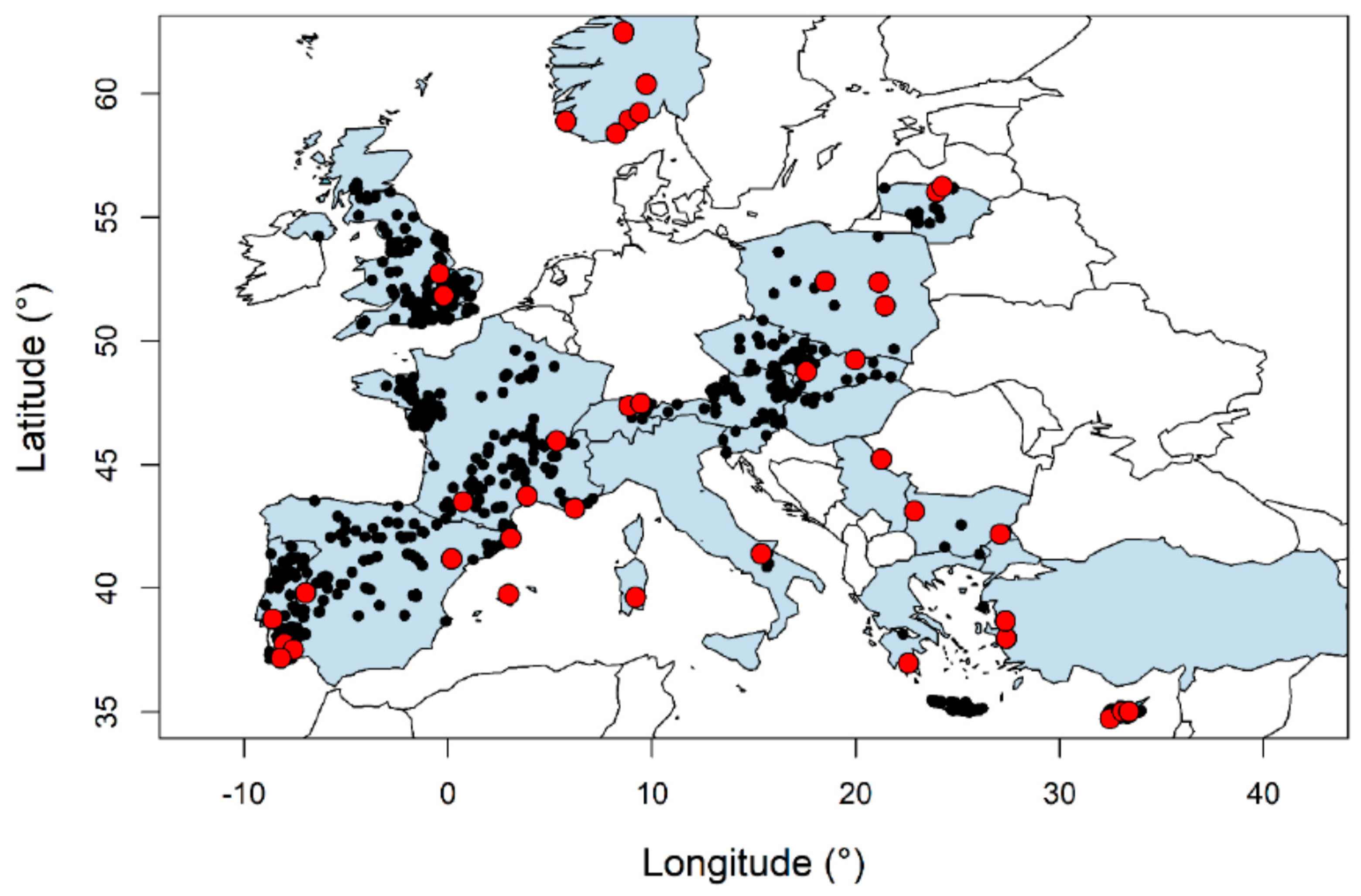
In-channel MAR schemes are almost entirely located on ephemeral watercourses, with only a very limited number on perennial rivers. A catalogue of intermittent rivers and ephemeral streams (IRES) was recently developed for gauged catchments as part of the Science and Management of Intermittent Rivers and Ephemeral Streams (SMIRES) project [106]. A total of 728 gauging stations from 119 countries were found to meet the intermittent flow criteria, and a subset of these were included in the catalogue. Their locations are shown in Figure 7, showing that IRES are not only widespread in dry climates but also in the headwaters of many drainage basins in wetter climates [106]. Their prevalence is expected to increase due to global change and increased water use, as shifts from perennial to intermittent flow regimes will increasingly occur in semiarid areas and small basins [106]. As small, intermittent streams are much less likely to be gauged in the first place, this represents only a small subsection of ephemeral rivers in Europe. Nevertheless, this indicates there may be significant potential for in-channel modifications for MAR in Europe, providing other issues can be managed.
The main human pressures on IRES in EU are hydromorphological (40%), diffuse source pollution (38%), atmospheric deposition (38%), point source pollution (18%), and abstraction (7%) [106]. Morphology changes include the construction of dams or weirs (and associated capture of sediments), straightening and channelization, disconnection of floodplains. Under the requirements of the Water Framework Directive, both surface water and groundwater bodies need to meet “Good” status by 2027, and hence development of in-channel MAR to support the quantitative and chemical status groundwater bodies must not cause significant adverse hydromorphological issues by constructing large dams. However, most of these structures have dams of low height, and in some cases, have a negligible dam height, and in the case of NFM measures, debris dams or dams constructed naturally by beavers may be employed to enhance recharge.
According to the driving forces to achieve good status of groundwater bodies from the Water Framework Directive and the large number of intermittent streams, it can be seen there is a great potential for the implementation of in-channel modifications as a measure to increase water security or contribute to the achievement/maintenance of the good groundwater status in Europe. In fact, in South Portugal, the Regional Plan for Water Efficiency [11] was recently published with the aim of implementing measures to increase the efficiency of water use and tackle water scarcity in the region of Algarve, a region subject to frequent drought events, and climate change is expected to increase these occurrences. Within this plan, the implementation of in-channel modification in ephemeral streams have been considered as a possible solution to enhance natural recharge and thus, increase coastal aquifers resilience to drought and seawater intrusion. On the other hand, one of the reasons that may seem to create some resistance to the application of such methodologies is likely to be the lack of regulation and specific policy on MAR in Europe, which is limited to four EU countries at present [107], where water used for MAR must meet the regulations of the EU Groundwater Directive (no discharge of List 1 substances, and not exceed guidance values for List 2 substances) [108].

8. Conclusions and Recommendations

In-channel MAR schemes bring clear local benefits in terms of increasing groundwater levels, improving groundwater quality, and allowing increased use of groundwater, usually for irrigation in the local area surrounding the recharge dam. Regional benefits can be achieved (e.g., reversing a regional groundwater deficit, preventing saline intrusion, or achieving regional improvement in water quality), provided recharge dams are of sufficient size and number, and located in areas with sufficient inflow and favorable aquifer properties. To achieve regional benefits, a series of structures along a watercourse are often needed, possibly in combination with other types of MAR (rainwater harvesting, subsurface dams, etc.). Water quality improvements to the underlying aquifer have regularly been reported, including but not limited to reductions in EC, TDS, and fluoride concentrations. However, the source water quality needs to be suitable, avoiding locations with upstream industrial discharges or significant contaminated runoff from agriculture. Very few schemes have reported water quality issues. Siltation appears to be an issue that can be managed by appropriate design and maintenance.
Further work could be directed towards investigating on a regional basis the potential for recharge dams on ephemeral streams in Europe, by combining the location of ephemeral streams with areas of suitable hydrogeology, and WFD status. Challenges are expected to arise from the competing interests of meeting “Good” status for both surface water and groundwater, and the drivers towards dam removal where possible. Providing evidence of recharge through existing dam structures and further evaluation of river restoration, NFM and NBS measures and the potential additional recharge these may generate could result in MAR schemes that do not result in significant adverse impacts to surface waters. NFM and NBS measures appear to slightly increase recharge to the underlying aquifer, but further work is required to quantify the water storage upstream of beaver dams, recharge rates through the ponds, the water seepage and return to the stream, and the recharge component associated with overbank flow/floodplain inundation.
Sand storage dams are likely to have less applicability in Europe due to their small size, limited water storage, and associated water availability. However, they could be utilized where enhanced recharge to the underlying aquifer is needed, in areas of suitable catchment slope, bed load and sedimentation rates, and magnitude and timing of flood flows, where a recharge dam would be expected to fill with sediment. Alternatively, where sediment control dams are required, considering aquifer properties when locating dams could result in dual benefits.
Identified gaps in knowledge include comparisons between natural infiltration rates and subsequent recharge in ephemeral streams, the increase in recharge expected from in-channel MAR schemes, and uncertainties in how recharge dams will perform under climate change. No studies were identified where the impact of climate change on recharge at recharge dams had been estimated. It is expected that this will depend on the design criteria of the dam with respect to its inflow, as well as the expected changes of rainfall patterns of a given region.
The research reviewed in this current paper suggests that in-channel MAR can contribute to solve both local and regional issues, including reversing groundwater deficits, mitigating saline intrusion, and providing locally increased water supply. It appears that there are many locations in Europe where suitable conditions for in-channel MAR exist; thus, considering climate change and increasing water scarcity, in-channel MAR modifications are likely to be a viable solution for tackling such problems.

Supplementary Materials

The following are available online at https://www.mdpi.com/2073-4441/12/11/3099/s1, Appendix 1: Recharge dam database.

Author Contributions

Conceptualization, K.S; literature review and data processing, K.S.; writing—original draft preparation, K.S.; writing—review and editing, K.S., L.R.D.C. and J.-P.M.; supervision, J.-P.M.; funding acquisition, J.-P.M. All authors have read and agreed to the published version of the manuscript.

Funding

The research leading to these results received funding from the European Union’s Horizon 2020 research and innovation programme under the Marie Skłodowska-Curie grant agreement no. 814066 (Managed Aquifer Recharge Solutions Training Network—MARSoluT).

Acknowledgments

The authors wish to thank the three anonymous peer reviewers for their comments which have contributed to improve the quality and robustness of this study.

Conflicts of Interest

The authors declare no conflict of interest.

References

  1. Dillon, P.; Stuyfzand, P.; Grischek, T.; Lluria, M.; Pyne, R.D.G.; Jain, R.C.; Bear, J.; Schwarz, J.; Wang, W.; Fernandez, E.; et al. Sixty Years of Global Progress in Managed Aquifer Recharge. Hydrogeol. J. 2019, 27, 1–30. [Google Scholar] [CrossRef] [Green Version]
  2. Spinoni, J.; Naumann, G.; Vogt, J.V. Pan-European Seasonal Trends and Recent Changes of Drought Frequency and Severity. Glob. Planet. Change 2017, 148, 113–130. [Google Scholar] [CrossRef]
  3. Gudmundsson, L.; Leonard, M.; Do, H.X.; Westra, S.; Seneviratne, S.I. Observed Trends in Global Indicators of Mean and Extreme Streamflow. Geophys. Res. Lett. 2019, 46, 756–766. [Google Scholar] [CrossRef] [Green Version]
  4. Gudmundsson, L.; Seneviratne, S.I. Observation-Based Gridded Runoff Estimates for Europe (E-RUN Version 1.1). Earth Syst. Sci. Data 2016, 8, 279–295. [Google Scholar] [CrossRef] [Green Version]
  5. Hall, J.; Arheimer, B.; Aronica, G.T.; Bilibashi, A.; Boháč, M.; Bonacci, O.; Borga, M.; Burlando, P.; Castellarin, A.; Chirico, G.B.; et al. A European Flood Database: Facilitating Comprehensive Flood Research beyond Administrative Boundaries. Proc. IAHS 2015, 370, 89–95. [Google Scholar] [CrossRef] [Green Version]
  6. Hankin, B.; Arnott, S.; Whiteman, M.; Burgess-Gamble, L.; Rose, S. Working with Natural Processes—Using the Evidence Base to Make the Case for Natural Flood Management; Environment Agency: Bristol, UK, 2017.
  7. Da Costa, L.R.D.; Monteiro, J.P.P.G.; Hugman, R.T. Assessing the Use of Harvested Greenhouse Runoff for Managed Aquifer Recharge to Improve Groundwater Status in South Portugal. Environ. Earth Sci. 2020, 79, 1–15. [Google Scholar] [CrossRef]
  8. Sprenger, C.; Hartog, N.; Hernández, M.; Vilanova, E.; Grützmacher, G.; Scheibler, F.; Hannappel, S. Inventory of Managed Aquifer Recharge Sites in Europe: Historical Development, Current Situation and Perspectives. Hydrogeol. J. 2017, 25, 1909–1922. [Google Scholar] [CrossRef] [Green Version]
  9. Stefan, C.; Ansems, N. Web-Based Global Inventory of Managed Aquifer Recharge Applications. Sustain. Water Resour. Manag. 2018, 4, 153–162. [Google Scholar] [CrossRef] [Green Version]
  10. Huber, A.; Scheibler, F. Catalogue of European MAR applications. DEMEAU FP7 Project. Available online: https://demeau-fp7.eu/system/files/results/d11.1 catalogue of European MAR applications_0.pdf (accessed on 24 August 2020).
  11. Machado, P. Bases Do Plano Regional de Eficiência Hídrica: REGIÃO DO ALGARVE; Volume I—Memória Descritiva; Agência Portuguesa do Ambiente: Amadora, Portugal, 2020; Volume 1.
  12. Valverde, J.P.B.; Stefan, C.; Nava, A.P.; da Silva, E.B.; Vivar, H.L.P. Inventory of Managed Aquifer Recharge Schemes in Latin America and the Caribbean. Sustain. Water Resour. Manag. 2018, 4, 163–178. [Google Scholar] [CrossRef]
  13. Schmitt, R.J.P.; Kittner, N.; Kondolf, G.M.; Kammen, D.M. Deploy Diverse Renewables to Save Tropical Rivers. Nature 2019, 569, 330–332. [Google Scholar] [CrossRef] [PubMed]
  14. Martos-Rosillo, S.; Ruiz-Constán, A.; González-Ramón, A.; Mediavilla, R.; Martín-Civantos, J.M.; Martínez-Moreno, F.J.; Jódar, J.; Marín-Lechado, C.; Medialdea, A.; Galindo-Zaldívar, J.; et al. The Oldest Managed Aquifer Recharge System in Europe: New Insights from the Espino Recharge Channel (Sierra Nevada, Southern Spain). J. Hydrol. 2019, 578, 124047. [Google Scholar] [CrossRef]
  15. IGRAC. Artificial Recharge of Groundwater in the World Report; IGRAC, 2007. Available online: https://www.un-igrac.org/sites/default/files/resources/files/2008_IGRAC_Global%20MAR%20Inventory%20Report.pdf (accessed on 3 November 2020).
  16. Ishida, S.; Tsuchihara, T.; Yoshimoto, S.; Imaizumi, M. Sustainable Use of Groundwater with Underground Dams. Jpn. Agric. Res. Q. 2011, 45, 51–61. [Google Scholar] [CrossRef] [Green Version]
  17. Escalante, E.F.; Sauto, J.S.S.; Gil, R.C. Sites and Indicators of MAR as a Successful Tool to Mitigate Climate Change Effects in Spain. Water 2019, 11, 1943. [Google Scholar] [CrossRef] [Green Version]
  18. Ebrahim, Y.G.; Lautze, J.F.; Villholth, K.G. Managed Aquifer Recharge in Africa: Taking Stock and Looking Forward. Water 2020, 12, 1844. [Google Scholar] [CrossRef]
  19. Web of Science. Available online: https://www.webofknowledge.com/ (accessed on 29 May 2020).
  20. Chen, X.; Ling, M.-H.; Zhou, Q.; Zhang, Z.-C.; Cheng, Q.-B. Numerical Modeling the Role of Rubber Dams on Groundwater Recharge and Phreatic Evaporation Loss in Riparian Zones. Environ. Earth Sci. 2012, 65, 345–352. [Google Scholar] [CrossRef]
  21. Djuma, H.; Bruggeman, A.; Camera, C.; Eliades, M.; Kostarelos, K. The Impact of a Check Dam on Groundwater Recharge and Sedimentation in an Ephemeral Stream. Water 2017, 9, 813. [Google Scholar] [CrossRef] [Green Version]
  22. Abdalla, O.A.E.; Al-Rawahi, A.S. Groundwater Recharge Dams in Arid Areas as Tools for Aquifer Replenishment and Mitigating Seawater Intrusion: Example of AlKhod, Oman. Environ. Earth Sci. 2013, 69, 1951–1962. [Google Scholar] [CrossRef]
  23. de Laat, P.J.M.; Nonner, J.C. Artificial Recharge with Surface Water; a Pilot Project in Wadi Madoneh, Jordan. Environ. Earth Sci. 2012, 65, 1251–1263. [Google Scholar] [CrossRef]
  24. Xanke, J.; Goeppert, N.; Sawarieh, A.; Liesch, T.; Kinger, J.; Ali, W.; Hötzl, H.; Hadidi, K.; Goldscheider, N. Impact of Managed Aquifer Recharge on the Chemical and Isotopic Composition of a Karst Aquifer, Wala Reservoir, Jordan. Hydrogeol. J. 2015, 23, 1027–1040. [Google Scholar] [CrossRef]
  25. Salameh, E.; Abdallat, G.; van der Valk, M. Planning Considerations of Managed Aquifer Recharge (MAR) Projects in Jordan. Water 2019, 11, 182. [Google Scholar] [CrossRef] [Green Version]
  26. Gale, I.; Macdonald, D.; Calow, R.; Neumann, I.; Moench, M.; Kulkarni, H.; Mudrakartha, S.; Palanisami, K. Managed Aquifer Recharge: An Assessment of Its Role and Effectiveness in Watershed Management; Final Report for DFID KAR Project R8169, Augmenting Groundwater Resources by Artificial Recharge—AGRAR; British Geological Survey: Nottingham, UK, 2006. [Google Scholar]
  27. Kulkarni, H.; Badarayani, U.; Phadnis, V. Variability and Scale Factors in Artificial Recharge from the Deccan Basalts of India: A Case Study from Kolwan Valley of Pune District in Maharashtra, India. In Proceedings of the 5th International Symposium on Management of Aquifer Recharge, ISMAR 5, Berlin, Germany, 11–16 June 2005; pp. 705–713. [Google Scholar]
  28. Sharda, V.N.; Kurothe, R.S.; Sena, D.R.; Pande, V.C.; Tiwari, S.P. Estimation of Groundwater Recharge from Water Storage Structures in a Semi-Arid Climate of India. J. Hydrol. 2006, 329, 224–243. [Google Scholar] [CrossRef]
  29. Parimalarenganayaki, S.; Elango, L. Assessment of Effect of Recharge from a Check Dam as a Method of Managed Aquifer Recharge by Hydrogeological Investigations. Environ. Earth Sci. 2015, 73, 5349–5361. [Google Scholar] [CrossRef]
  30. Dashora, Y.; Dillon, P.; Maheshwari, B.; Soni, P.; Dashora, R.; Davande, S.; Purohit, R.C.; Mittal, H.K. A Simple Method Using Farmers’ Measurements Applied to Estimate Check Dam Recharge in Rajasthan, India. Sustain. Water Resour. Manag. 2018, 4, 301–316. [Google Scholar] [CrossRef]
  31. Glendenning, C.J.; Vervoort, R.W. Hydrological Impacts of Rainwater Harvesting (RWH) in a Case Study Catchment: The Arvari River, Rajasthan, India. Part 1: Field-Scale Impacts. Agric. Water Manag. 2010, 98, 331–342. [Google Scholar] [CrossRef]
  32. Farooqi, M.A.; Sudarshan, G.; Sooryanarayana, K.R.; Manzar, A.; Sivaramakrishnan, J. Artificial Recharge Practices—Some Experimental Projects. Spec. Publ. Geol. Soc. India 2016, 5, 119–130. [Google Scholar] [CrossRef]
  33. Martín-Rosales, W.; Gisbert, J.; Pulido-Bosch, A.; Vallejos, A.; Fernández-Cortés, A. Estimating Groundwater Recharge Induced by Engineering Systems in a Semiarid Area (Southeastern Spain). Environ. Geol. 2007, 52, 985–995. [Google Scholar] [CrossRef]
  34. Al-Muttair, B.F.F.; Sendil, U.; Al-Turbak, A.S. Management of Recharge Dams in Saudi Arabia. J. Water Resour. Plan. Manag. 1994, 120, 749–763. [Google Scholar] [CrossRef]
  35. Alderwish, A.M. Induced Recharge at New Dam Sites—Sana’a Basin, Yemen. Arab. J. Geosci. 2010, 3, 283–293. [Google Scholar] [CrossRef]
  36. Kalantari, N.; Rangzan, K. Assessment of Three Water Harvesting Structures in Iran. In Proceedings of the 26th WEDC Conference, Water Sanitation and Hygiene: Challenges of the Millennium, Dhaka, Bangladesh, 5–9 November 2000; pp. 26–28. [Google Scholar]
  37. CGWB. Master Plan for Artificial Recharge to Ground Water in India; Central Ground Water Board: New Delhi, India, 2013.
  38. Stonestrom, D.A.; Constantz, J. Heat as a Tool for Studying the Movement of Ground Water near Streams; USGS Circular 1260; U.S. Geological Survey: Reston, VA, USA, 2008.
  39. Montoroi, J.-P.; Grünberger, O.; Nasri, S. Groundwater Geochemistry of a Small Reservoir Catchment in Central Tunisia. Appl. Geochem. 2002, 17, 1047–1060. [Google Scholar] [CrossRef]
  40. Sun, R.; Xing, L.; Xianguo, W.; Lui, Q. Experience of Capturing Flood Water for Artificial Recharge of Groundwater in North China. In Proceedings of the 5th International Symposium on Management of Aquifer Recharge, ISMAR 5, Berlin, Germany, 12–16 June 2005; pp. 727–732. [Google Scholar]
  41. Rahman, M.A.; Rusteberg, B.; Gogu, R.C.; Lobo Ferreira, J.P.; Sauter, M.; Ferreira, J.P.L.; Sauter, M. A New Spatial Multi-Criteria Decision Support Tool for Site Selection for Implementation of Managed Aquifer Recharge. J. Environ. Manag. 2012, 99, 61–75. [Google Scholar] [CrossRef]
  42. Kaliraj, S.; Chandrasekar, N.; Magesh, N.S. Evaluation of Multiple Environmental Factors for Site-Specific Groundwater Recharge Structures in the Vaigai River Upper Basin, Tamil Nadu, India, Using GIS-Based Weighted Overlay Analysis. Environ. Earth Sci. 2015, 74, 4355–4380. [Google Scholar] [CrossRef]
  43. Bailey, D.; Goonetilleke, A.; Campbell, D. A New Fuzzy Multicriteria Evaluation Method for Group Site Selection in GIS. J. Multi-Crit. Decis. Anal. 2003, 12, 337–347. [Google Scholar] [CrossRef] [Green Version]
  44. Kalantari, N.; Rangzan, K.; Thigale, S.S.; Rahimi, M.H. Site Selection and Cost-Benefit Analysis for Artificial Recharge in the Baghmalek Plain, Khuzestan Province, Southwest Iran. Hydrogeol. J. 2010, 18, 761–773. [Google Scholar] [CrossRef]
  45. CGWB. Manual on Artificial Recharge of Groundwater; Central Ground Water Board: New Delhi, India, 2007.
  46. Parimalarenganayaki, S.; Elango, L. Quantification of Groundwater Recharge and River Bed Clogging by Daily Water Level Measurements in a Check Dam. Arab. J. Geosci. 2018, 11, 174. [Google Scholar] [CrossRef]
  47. Salem, S.B.H.; Chkir, N.; Zouari, K.; Cognard-Plancq, A.L.; Valles, V.; Marc, V. Natural and Artificial Recharge Investigation in the Zéroud Basin, Central Tunisia: Impact of Sidi Saad Dam Storage. Environ. Earth Sci. 2012, 66, 1099–1110. [Google Scholar] [CrossRef]
  48. Sukhija, B.S.; Reddy, D.V.; Nandakumar, M.V. A Method for Evaluation of Artificial Recharge through Percolation Tanks Using Environmental Chloride. Ground Water 1997, 35, 161–165. [Google Scholar] [CrossRef]
  49. Al-Saqri, S.; Al-Maktoumi, A.; Al-Ismaily, S.; Kacimov, A.; Al-Busaidi, H. Hydropedology and Soil Evolution in Explaining the Hydrological Properties of Recharge Dams in Arid Zone Environments. Arab. J. Geosci. 2016, 9, 1–12. [Google Scholar] [CrossRef]
  50. Hatch, C.E.; Fisher, A.T.; Revenaugh, J.S.; Constantz, J.; Ruehl, C. Quantifying Surface Water-Groundwater Interactions Using Time Series Analysis of Streambed Thermal Records: Method Development. Water Resour. Res. 2006, 42, 1–14. [Google Scholar] [CrossRef] [Green Version]
  51. Neumann, I.; Barker, J.; Macdonald, D.; Gale, I. Numerical Approaches for Approximating Technical Effectiveness of Artificial Recharge Structures; Groundwater Systems and Water Quality Programme Commissioned Report CR/04/265N; British Geological Survey: Nottingham, UK, 2004. [Google Scholar]
  52. Neumann, I.; Barker, J.; Macdonald, D.; Gale, I. Approximating Technical Effectiveness of Low Technology Aquifer Recharge Structures Using Simple Numerical Methods. In Proceedings of the 5th International Symposium on Management of Aquifer Recharge, ISMAR 5, Berlin, Germany, 12–16 June 2005; pp. 204–209. [Google Scholar]
  53. Missimer, T.M.; Guo, W.; Maliva, R.G.; Rosas, J.; Jadoon, K.Z. Enhancement of Wadi Recharge Using Dams Coupled with Aquifer Storage and Recovery Wells. Environ. Earth Sci. 2015, 73, 7723–7731. [Google Scholar] [CrossRef]
  54. Shanafield, M.; Cook, P.G. Transmission Losses, Infiltration and Groundwater Recharge through Ephemeral and Intermittent Streambeds: A Review of Applied Methods. J. Hydrol. 2014, 511, 518–529. [Google Scholar] [CrossRef]
  55. Boughton, W. The Australian Water Balance Model. Environ. Model. Softw. 2004, 19, 943–956. [Google Scholar] [CrossRef]
  56. Rossman, L.A. Storm Water Management Model (SWMM) User’s Manual Version 5.1; U.S. Environmental Protection Agency: Cincinnati, OH, USA, 2015.
  57. Arnold, M.D.J.G. Large Area Hydrologic Modeling and Assessment Part I: Model Development. J. Am. Water Resour. Assoc. 1998, 34, 73–89. [Google Scholar] [CrossRef]
  58. Dashora, Y.; Dillon, P.; Maheshwari, B.; Soni, P.; Mittal, H.K.; Dashora, R.; Singh, P.K.; Purohit, R.C.; Katara, P. Hydrologic and Cost Benefit Analysis at Local Scale of Streambed Recharge Structures in Rajasthan (India) and Their Value for Securing Irrigation Water Supplies. Hydrogeol. J. 2019, 27, 1889–1909. [Google Scholar] [CrossRef] [Green Version]
  59. Ashraf, M.; Kahlown, M.A.; Ashfaq, A. Impact of Small Dams on Agriculture and Groundwater Development: A Case Study from Pakistan. Agric. Water Manag. 2007, 92, 90–98. [Google Scholar] [CrossRef]
  60. Mehdizadeh, S.S.; Ketabchi, H.; Ghoroqi, M.; Hasanzadeh, A.K. Experimental and Numerical Assessment of Saltwater Recession in Coastal Aquifers by Constructing Check Dams. J. Contam. Hydrol. 2020, 231, 103637. [Google Scholar] [CrossRef]
  61. Martin, R. Clogging Issues Associated with Managed Aquifer Recharge Methods; IAH Comission and Managing Aquifer Recharge: Adelaide, Australia, 2013. [Google Scholar]
  62. Gowrisankar, G.; Jagadeshan, G.; Elango, L. Managed Aquifer Recharge by a Check Dam to Improve the Quality of Fluoride-Rich Groundwater: A Case Study from Southern India. Environ. Monit. Assess. 2017, 189, 1–13. [Google Scholar] [CrossRef]
  63. Mudrakartha, S. Augmenting Groundwater Resources by Artificial Recharge Research Site at Aravalli Hills, Gujarat, India; AGRAR Inception Report; Vikram Sarabhai Centre for Development Interaction (VIKSAT): Ahmedabad, India, 2003. [Google Scholar]
  64. Bhagavan, S.V.B.K.; Raghu, V. Utility of Check Dams in Dilution of Fluoride Concentration in Ground Water and the Resultant Analysis of Blood Serum and Urine of Villagers, Anantapur District, Andhra Pradesh, India. Environ. Geochem. Health 2005, 27, 97–108. [Google Scholar] [CrossRef]
  65. Ta’any, R.; Jiries, A.; Al Momani, M.; Samarah, M. Evaluation of Water Quality of Groundwater Recharge in Wadi Feifa, Southern Jordan Valley. Water Technol. 2009, 5, 88–93. [Google Scholar]
  66. Dong, S.; Liu, B.; Liu, H.; Wang, S.; Wang, L. Impacts of Groundwater Recharge from Rubber Dams on the Hydrogeological Environment in Luoyang Basin, China. Sci. World J. 2014, 2014, 1–10. [Google Scholar] [CrossRef]
  67. Baurne, G. “Trap-Dams”: Artificial Subsurface Storage of Water. Water Int. 1984, 9, 2–9. [Google Scholar] [CrossRef]
  68. Ertsen, M.; Hut, R. Two Waterfalls Do Not Hear Each Other. Sand-Storage Dams, Science and Sustainable Development in Kenya. Phys. Chem. Earth Parts A/B/C 2009, 34, 14–22. [Google Scholar] [CrossRef]
  69. Hut, R.; Ertsen, M.; Joeman, N.; Vergeer, N.; Winsemius, H.; van de Giesen, N. Effects of Sand Storage Dams on Groundwater Levels with Examples from Kenya. Phys. Chem. Earth Parts A/B/C 2008, 33, 56–66. [Google Scholar] [CrossRef]
  70. Lasage, R.; Aerts, J.; Mutiso, G.C.M.; de Vries, A. Potential for Community Based Adaptation to Droughts: Sand Dams in Kitui, Kenya. Phys. Chem. Earth Parts A/B/C 2008, 33, 67–73. [Google Scholar] [CrossRef]
  71. Eisma, J.A.; Merwade, V.M. Investigating the Environmental Response to Water Harvesting Structures: A Field Study in Tanzania. Hydrol. Earth Syst. Sci. 2020, 24, 1891–1906. [Google Scholar] [CrossRef] [Green Version]
  72. Lasage, R.; Aerts, J.C.J.H.; Verburg, P.H.; Sileshi, A.S. The Role of Small Scale Sand Dams in Securing Water Supply under Climate Change in Ethiopia. Mitig. Adapt. Strateg. Glob. Chang. 2013, 20, 317–339. [Google Scholar] [CrossRef]
  73. Viducich, J.M.G. Spillway Staging and Selective Sediment Deposition in Sand Storage Dams. Master’s Thesis, Oregon State University, Corvalis, OR, USA, 2015. [Google Scholar]
  74. Excellent Foundation. Northern Rangelands Sand Dam Programme 2015–2019. Available online: https://www.excellentdevelopment.com/Handlers/Download.ashx?IDMF=056884fa-3f56-4b7c-bad5-dc9cc93764c9 (accessed on 3 November 2020).
  75. ASDF. Africa Sand Dam Foundation Impact Report 2017–2018. Available online: https://asdfafrica.org/resource-center/downloads?download=1:asdf-impact-and-theory-of-change-2018-08-08-final (accessed on 3 November 2020).
  76. Wang, Y.; Fu, B.; Chen, L.; Lü, Y.; Gao, Y. Check Dam in the Loess Plateau of China: Engineering for Environmental Services and Food Security. Environ. Sci. Technol. 2011, 45, 10298–10299. [Google Scholar] [CrossRef]
  77. Jin, Z.; Cui, B.; Song, Y.; Shi, W.; Wang, K.; Wang, Y.; Liang, J. How Many Check Dams Do We Need to Build on the Loess Plateau? Environ. Sci. Technol. 2012, 46, 8527–8528. [Google Scholar] [CrossRef]
  78. Forzieri, G.; Gardenti, M.; Caparrini, F.; Castelli, F. A Methodology for the Pre-Selection of Suitable Sites for Surface and Underground Small Dams in Arid Areas: A Case Study in the Region of Kidal, Mali. Phys. Chem. Earth Parts A/B/C 2008, 33, 74–85. [Google Scholar] [CrossRef]
  79. Gijsbertsen, C. A Study to Up-Scaling of the Principle and Sediment (Transport) Processes behind, Sand Storage Dams, Kitui District, Kenya. Master’s Thesis, Vrije Universiteit Amsterdam, Amsterdam, The Netherlands, 2007. [Google Scholar]
  80. Maddrell, S.; Neal, I. Building Sand Dams—A Practical Guide; Excellent Development: London, UK, 2013. [Google Scholar]
  81. Van Haveren, B.P. Dependable Water Supplies from Valley Alluvium in Arid Regions. Environ. Monit. Assess. 2004, 99, 259–266. [Google Scholar] [CrossRef]
  82. Quinn, R.; Rushton, K.; Parker, A. An Examination of the Hydrological System of a Sand Dam during the Dry Season Leading to Water Balances. J. Hydrol. X 2019, 4, 100035. [Google Scholar] [CrossRef]
  83. Quinn, R.; Parker, A.; Rushton, K. Evaporation from Bare Soil: Lysimeter Experiments in Sand Dams Interpreted Using Conceptual and Numerical Models. J. Hydrol. 2018, 564, 909–915. [Google Scholar] [CrossRef]
  84. Luo, Z.; Yong, C.; Fan, J.; Shao, M.; Wang, S.; Jin, M. Precipitation Recharges the Shallow Groundwater of Check Dams in the Loessial Hilly and Gully Region of China. Sci. Total Environ. 2020, 742, 140625. [Google Scholar] [CrossRef]
  85. Aerts, J.; Lasage, R.; Beets, W.; de Moel, H.; Mutiso, G.; Mutiso, S.; de Vries, A. Robustness of Sand Storage Dams under Climate Change. Vadose Zo. J. 2007, 6, 572–580. [Google Scholar] [CrossRef]
  86. Rockström, J. Water Resources Management in Smallholder Farms in Eastern and Southern Africa: An Overview. Phys. Chem. Earth Part B: Hydrol. Ocean. Atmos. 2000, 25, 275–283. [Google Scholar] [CrossRef]
  87. Van Haveren, B.P.; Jackson, W.L.; Lusby, G.C. Sediment Deposition behind Sheep Creek Barrier Dam, Southern Utah. J. Hydrol. 1987, 26, 185–196. [Google Scholar]
  88. De Trincheria, J.; Leal, W.F.; Otterpohl, R. Towards a Universal Optimization of the Performance of Sand Storage Dams in Arid and Semi-Arid Areas by Systematically Minimizing Vulnerability to Siltation: A Case Study in Makueni, Kenya. Int. J. Sediment Res. 2018, 33, 221–233. [Google Scholar] [CrossRef]
  89. De Trincheria, J.; Wibbing, J.; Leal, F.W.; Otterpohl, R. Practical Recommendations to Prevent, Restore and Rehabilitate Silted-up Sand Storage Dams in Arid and Semi-Arid Areas. In Proceedings of the 7th RWSN Forum “Water Everyone” Conference, Abidjan, Ivory Coast, 10–15 November 2016. [Google Scholar]
  90. Quinn, R.; Avis, O.; Decker, M.; Parker, A.; Cairncross, S. An Assessment of the Microbiological Water Quality of Sand Dams in Southeastern Kenya. Water 2018, 10, 708. [Google Scholar] [CrossRef] [Green Version]
  91. Moïse, N.; Kaluli, J.W.; Home, P.G. Evaluation of Sand-Dam Water Quality and Its Suitability for Domestic Use in Arid and Semi-Arid Environments: A Case Study of Kitui-West Sub-County, Kenya. Int. J. Water Resour. Environ. Eng. 2019, 11, 91–111. [Google Scholar] [CrossRef] [Green Version]
  92. Ferreira, J.P.L.; Leitão, T.E. Demonstrating Managed Aquifer Recharge as a Solution for Climate Change Adaptation: Results from Gabardine Project and AsemwaterNet Coordination Action in the Algarve Region (Portugal). Acque Sotteranee—Ital. J. Groundw. 2014, 3, 15–22. [Google Scholar] [CrossRef] [Green Version]
  93. Leitao, T.E.; Ferreira, J.P.L.; Martins, T.; Henriques, M.J.; Mota, R.; Carvalho, T.; de Carvalho, J.M.; Agostinho, R.; Carvalho, R.; Sousa, R.; et al. MARSOL—Demonstrating Managed Aquifer Recharge as a Solution to Water Scarcity and Drought—Monitoring Results from the South Portugal MARSOL Demonstration Sites D4.3. 2016. Available online: http://www.marsol.eu/files/marsol-newsletter-issue05.pdf (accessed on 5 March 2020).
  94. Oliveira, M.M.; Ferreira, J.P.L.; Leitão, T.E.; Carvalho, T.; Costa, L.R.D.; Agostinho, R.; Monteiro, J.P. New Test of the GABARDINE Infiltration Basin for MAR in Rio Seco (Campina Da Faro Aquifer System, Algarve). In 10.° Seminário sobre Águas Subterrâneas; Associação Portuguesa dos Recursos Hídrico: Lisbon, Portugal, 2015; pp. 73–76. [Google Scholar]
  95. Leitão, T.E.; Ferreira, J.P.L.; Martins, T.; Oliveira, M.M.; Henriques, M.J.; Carvalho, T.; de Carvalho, J.M.; Agostinho, R.; Carvalho, R.; Sousa, R.; et al. MARSOL Demonstrating Managed Aquifer Recharge as a Solution to Water Scarcity and Drought: MAR to Improve the Groundwater Status in South Portugal D4.4. 2017. Available online: http://www.marsol.eu/files/marsol_d4-4_modelling-south-portugal-sites_20160726-compr.pdf (accessed on 3 November 2020).
  96. JBA Trust. Working with Natural Processes: A Catalogue of Nature-Based Flood Risk Management Projects in the UK. Available online: http://naturalprocesses.jbahosting.com/ (accessed on 22 May 2020).
  97. Barlow, J.; Moore, F.; Burgess-Gamble, L. Working with Natural Processes to Reduce Flood Risk—R&D Framework: Initiation Report; Report-SC13004/R1; Environmental Agency: Bristol, UK, 2014.
  98. Shuttleworth, E.L.; Evans, M.G.; Pilkington, M.; Spencer, T.; Walker, J.; Milledge, D.; Allott, T.E.H. Restoration of Blanket Peat Moorland Delays Stormflow from Hillslopes and Reduces Peak Discharge. J. Hydrol. X 2019, 2, 100006. [Google Scholar] [CrossRef]
  99. UK-POST. Natural Mitigation of Flood Risk. 2020. Available online: http://researchbriefings.files.parliament.uk/documents/POST-PN-0623/POST-PN-0623.pdf (accessed on 3 November 2020).
  100. de Visscher, M.; Nyssen, J.; Pontzeele, J.; Billi, P.; Frankl, A. Spatio-Temporal Sedimentation Patterns in Beaver Ponds along the Chevral River, Ardennes, Belgium. Hydrol. Process. 2014, 28, 1602–1615. [Google Scholar] [CrossRef] [Green Version]
  101. Jones, C.G.; Lawton, J.H.; Shachak, M. Organisms as Ecosystem Engineers. Oikos 1994, 69, 373–386. [Google Scholar] [CrossRef]
  102. Westbrook, C.J.; Cooper, D.J.; Butler, D.R. Beaver Hydrology and Geomorphology. In Treatise Geomorphology; Academic Press: Waltham, MA, USA, 2013; Volume 3, pp. 293–306. [Google Scholar]
  103. Neumayer, M.; Teschemacher, S.; Schloemer, S.; Zahner, V. Hydraulic Modeling of Beaver Dams and Evaluation of Their Impacts on Flood Events. Water 2020, 12, 300. [Google Scholar] [CrossRef] [Green Version]
  104. Smith, A.; Tetzlaff, D.; Gelbrecht, J.; Kleine, L.; Soulsby, C. Riparian Wetland Rehabilitation and Beaver Re-Colonization Impacts on Hydrological Processes and Water Quality in a Lowland Agricultural Catchment. Sci. Total Environ. 2020, 699, 134302. [Google Scholar] [CrossRef] [PubMed]
  105. Westbrook, C.J.; Cooper, D.J.; Baker, B.W. Beaver Dams and Overbank Floods Influence Groundwater—Surface Water Interactions of a Rocky Mountain Riparian Area. Water Resour. Res. 2006, 42, 1–12. [Google Scholar] [CrossRef]
  106. Sauquet, E.; van Meerveld, I.; Gallart, F.; Sefton, C.; Parry, S.; Gauster, T.; Laaha, G.; Alves, M.H.; Arnaud, P.; Banasik, K.; et al. Catalogue of European Intermittent Rivers and Ephemeral Streams; Technical Report SMIRES COST Action CA15113. Science and Management of Intermittent Rivers and Ephemeral Streams (SMIRES), 2020. Available online: https://hal.archives-ouvertes.fr/hal-02914572/file/Sauquet_et_al_2020Catalogue_SMIRES.pdf (accessed on 5 March 2020). [CrossRef]
  107. Escalante, E.F.; Casas, J.D.H.; Medeiros, A.M.V.; Sauto, J.S.S. Regulations and Guidelines on Water Quality Requirements for Managed Aquifer Recharge. International Comparison. Acque Sotteranee—Ital. J. Groundw. 2020, 9, 7–22. [Google Scholar] [CrossRef]
  108. EU. Directive 2006/118/EC on the Protection of Groundwater against Pollution and Deterioration. Off. J. Eur. Union 2006, 372, 19–31. [Google Scholar]
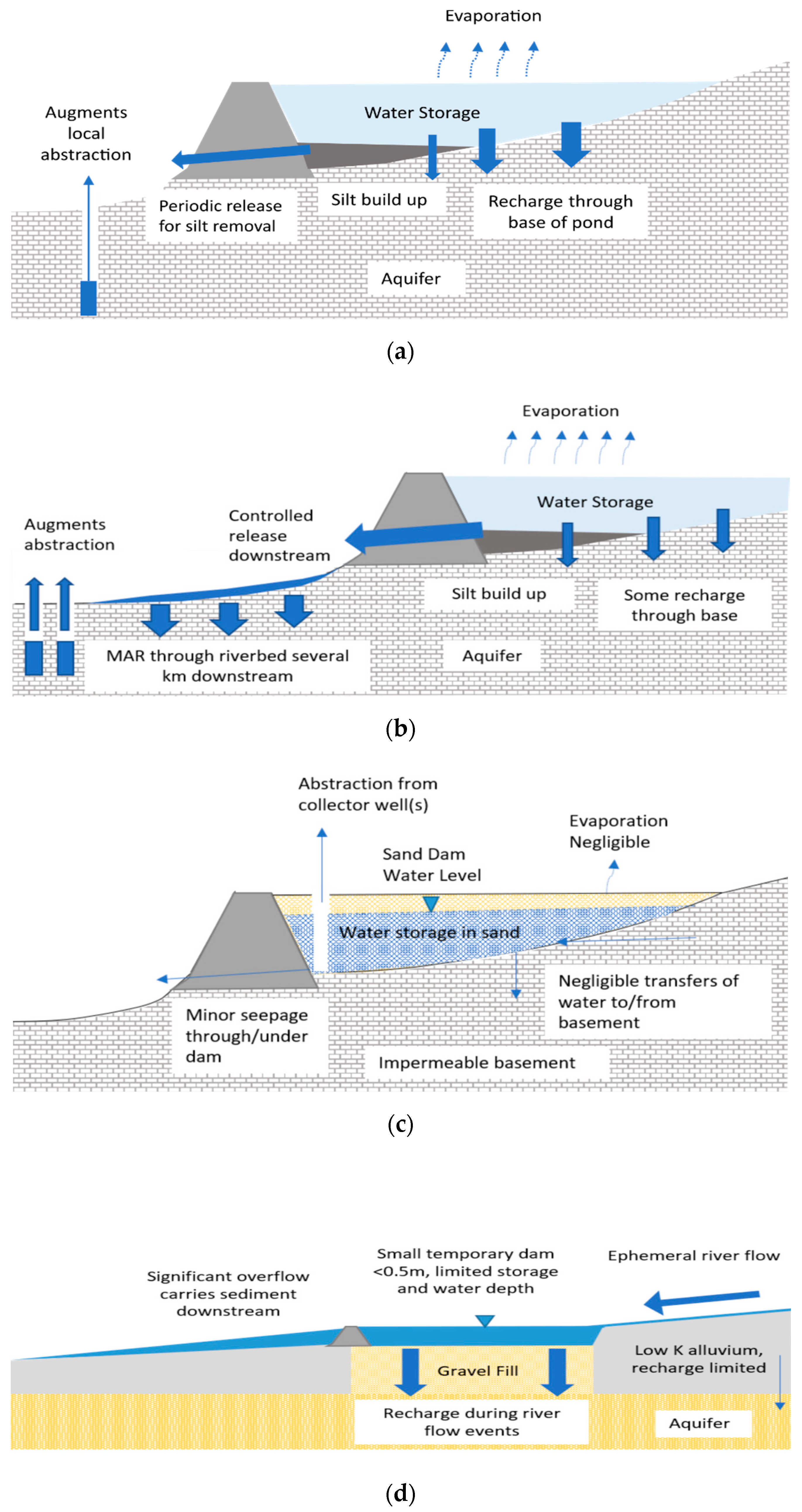
Figure 1. Types of in-channel modification for managed aquifer recharge (MAR): (a) a recharge dam where the majority of recharge occurs through the base of the pond, (b) a wadi-recharge dam where recharge is increased by controlled release downstream and infiltration through the riverbed, (c) a sand storage dam where water is stored within the semiartificial aquifer built up behind the dam, and (d) a riverbed modification to enhance recharge by removal of alluvial sediments and replacement with gravel fill.
Water 12 03099 g001
Figure 2. Recharge dam occurrence identified through the literature review.
Water 12 03099 g002
Figure 3. (a) Wadi-recharge dam, Jordan, reproduced with permission from de Laat and Nonner, Environmental Earth Sciences, published by Springer Nature (2011); and (b) Rubber dam, Russian River, USA, reproduced with permission from US Geological Survey (2008).
Water 12 03099 g003
Figure 4. (a) Dam storage capacity (m3) vs. estimated annual recharge (m3). (b) Estimated annual runoff vs. estimated groundwater recharge for recharge dams and wadi-recharge dams (no equivalent data for rubber dams).
Water 12 03099 g004
Figure 5. Runoff collection efficiency vs. recharge efficiency by type of recharge dam.
Water 12 03099 g005
Figure 6. Typical sand storage dams: (a) filled sand dam and (b) sand dam prior to filling. Photographs reproduced with permission from Ertsen and Hut, Physics and Chemistry of the Earth Parts A/B/C, published by Elsevier (2009).
Water 12 03099 g006
Figure 7. Location of intermittent rivers and ephemeral streams (IRES) catchments presented in the SMIRES catalogue. Red dots indicate examples of gauging stations included in the catalogue; black dots represent gauging stations that met the intermittence criteria, but were not included in the catalogue. Blue shading indicates countries of members involved in project data sharing. Reproduced with permission from Sauquet et al. under Creative Commons license 4.0 (2020).
Water 12 03099 g007
Table 1. Recharge dam statistics.
StatisticAnnual Average Rainfall (mm)Catchment Area (km2)Dam Capacity (m3)Dam Height (m)Volume Recharged (m3/year)Annual Runoff to Check Dam (m3)Annual Runoff (m3/km2)
Minimum1150.073081.596070185076
25th Percentile3590.8815433.010,25020,00023,864
Median3871.5370003.520,20039,00024,615
75th Percentile6737.4576,2505.080,375390,00059,656
Maximum1860177011,400,00011.019,340,00013,600,0002,951,278
Mean48159.20603,5524.5737,337853,625117,770
Count62788625795347
Table 2. Recharge efficiency and runoff collection efficiency of the recharge dams studied.
StatisticRecharge EfficiencyRunoff Collection Efficiency
Minimum0.170.0007
25th Percentile1.270.0289
Median2.820.0556
75th Percentile8.750.4000
Maximum124.883.0732
Mean6.690.3468
Count7953
Table 3. Typical sand storage dam parameters.
ParameterValue (Units)Reference
Annual average rainfall150–1000 mm/year[67,68,69,70,71,72,73,74,75]
Catchment area (km2)0.15 to 366 km2[73]
Catchment slope>2 degrees[79]
Riverbed slope0.2–5% (up to 16% in extreme cases)
0.01 to 3%
[73,79]
Bed rock depth<3 m/at surface[80]
Valley profileNarrow, 10–15 m[68]
Dam heightGenerally, 2–6 m[69,85]
Dam width10–1000 m typically, up to 30 m[69,85]
Sand storage volume20 to 140,000 m3Nissen-Peterson in [86]
Dam materialsStone masonry or concrete[68,85]
Construction period3–6 months[80]
Time to fillIdeally 1–3 years typically, within a year[73,80]
Fill materialFine—Coarse Sand[69,71]
Specific yield/Effective porosity0.1–0.3[69,81,82]
Water supplied780–8000 m3[70,71,72]
Publisher’s Note: MDPI stays neutral with regard to jurisdictional claims in published maps and institutional affiliations.