1. Introduction
Tsunamis are rare but catastrophic events which may have long or short-term return periods and may cause significant damage especially when they occur due to deep sea high intensity earthquakes [
1]. ETTs have resulted in mass casualty and economic destruction for the exposed countries throughout the history and also within the recent years [
2]. Therefore, reliable tsunami risk assessment (TRA) studies are vital for the affected regions to take effective mitigation measures and adaptation strategies. Researchers have proposed various risk assessment approaches for TRA, in the past decade [
3]. The two approaches that are used in the literature may be identified as: (i) the scenario-based deterministic approach and (ii) the probabilistic approach. In the scenario-based approach, the hazard and risk of credible worst-case scenario(s) are evaluated based on a few critical cases [
3,
4]. For the probabilistic approach of TRA, the most commonly used alternative is the stochastic generation of ETTs based on historical earthquakes, followed by wave propagation analysis which is followed by hazard and risk analysis of the outcome at the coastline [
5,
6,
7,
8,
9,
10]. Independent of ETTs, global warming, which is a long term event, is expected to result in an accelerated increase in SLR [
11,
12]. This may lead to higher risk of inundation of low-lying coastal areas [
13]. Consequently, damages due to coastal floods are expected to increase significantly during the 21st century and beyond, as sea level rises, making socio-economic damages in coastal regions more prevalent [
14]. Various studies have been conducted in the last two decades to evaluate, understand and develop management strategies and adaptation measures for risks due to SLR. Nicholls et al. [
15] studied the risk of flooding within the coastal flood plain due to SLR. They concluded that SLR without adaptation measures will cause significant flooding impacts at coastal zones in southern Mediterranean that are found to be particularly vulnerable to SLR. Purvis et al. [
16] carried out risk assessment of future coastal flooding to estimate the monetary loss at the UK coast in Somerset considering a given uncertainty over possible SLR. Hauer et al. [
17] estimated the number of people at risk of inundation due to SLR accounting for the ongoing population growth. The starting point of these risk assessment studies is the estimation of SLR over decades, which is studied extensively in the literature [
18,
19,
20,
21,
22,
23,
24]. These studies employ well established and robust methods, outcomes of which support similar observations. According to these studies, the expected global SLR will be inevitable over the century. More recently, similar estimates are also provided for spatial variation of SLR over various regions of World’s oceans [
25]. Along this line of work, SLR estimates (0.00–0.4518 m) for the Mediterranean Sea is also reported in [
26].
The hazard and risk analysis of ETTs should also be investigated in combination with other ocean or sea-based events like climate change-related SLR which have similar long return periods. One should also recognize that due to SLR, depth to sea surface also changes and this affects the wave generation and propagation of the ETT waves towards the shore. Simultaneous evaluation of SLR and ETTs is rare in the literature. Dall’Osso et al. [
27] performed a Probabilistic Tsunami hazard Assessment (PTHA) for Sidney, Australia. Method for Splitting Tsunamis (MOST) model generated by NOAA was used to simulate 36 ETTs with different annual probabilities and SLR conditions. They concluded that tsunami hazard is dramatically increased due to higher SLR conditions. Li et al. [
28] conducted a study on the rate of change of tsunami hazard by means of SLR for Macau, China. Probabilistic tsunami inundation maps were developed under different SLR conditions as, current, 0.5 m rise by 2060, and 1.0 m rise by 2100. The research revealed that SLR can cause a significant increase in the frequency of tsunami inundations which will be doubled and tripled for 2060 and 2100, respectively. Nagai et al. [
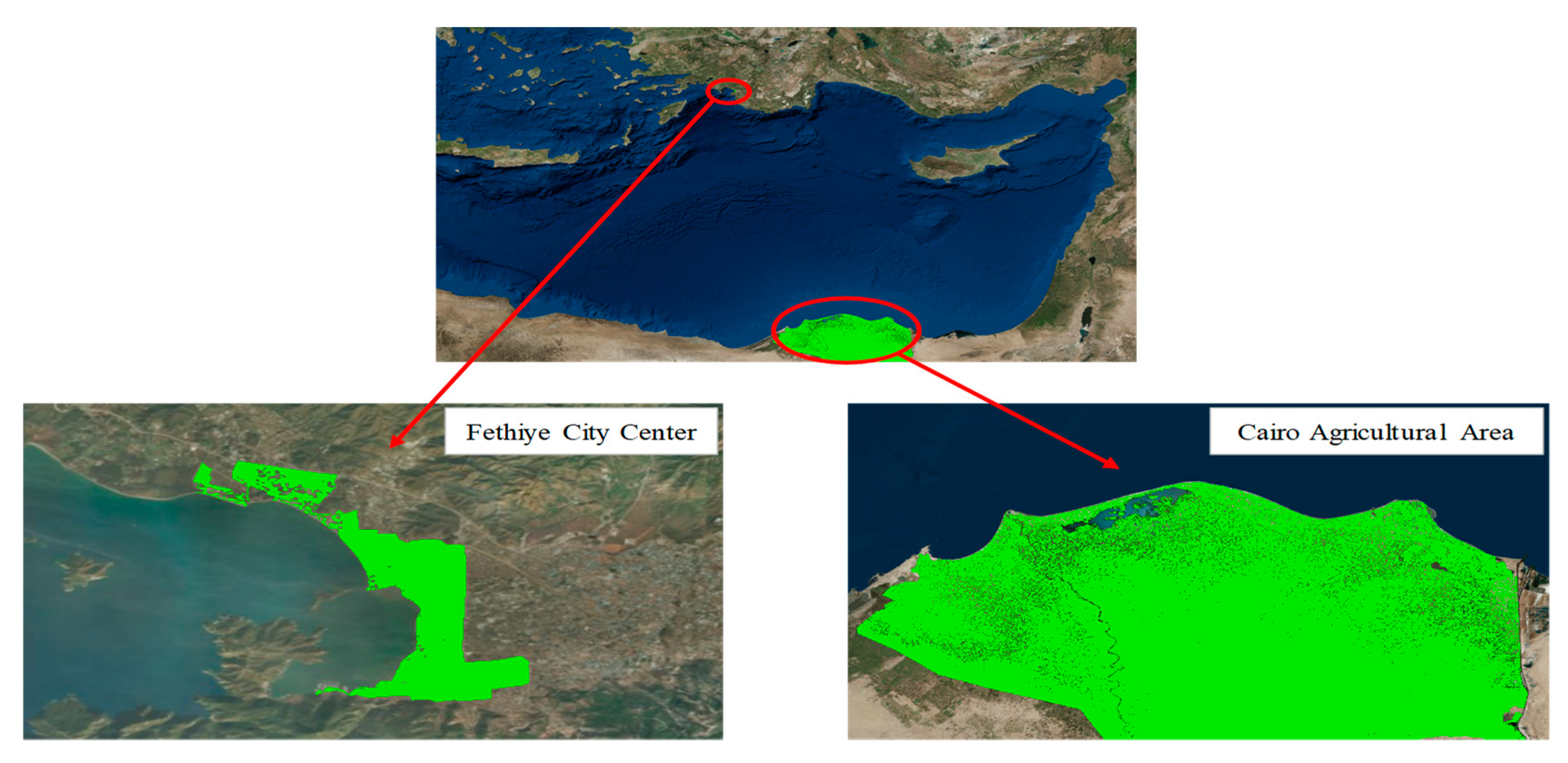
29] worked on a tsunami risk hazard on the number of affected people living in Tokyo Bay, Japan. The results obtained from the study showed that up to 1.0 m SLR will not significantly affect the current living conditions for the residential areas around Tokyo bay. However, SLR affected ETTs can be hazardous for the inhabitants in the future, according to the research. To the best of our knowledge, social and economic risks due to ETTs have not been evaluated in the literature considering the combined effects of SLR. Since ETTs will be experienced in the presence of climate change triggered SLR in the future, it is useful and necessary to evaluate the combined coastal risks especially for low lying regions. The goal of this study is to develop a methodology to estimate the aggregate risk due to ETTs in the presence of SLR and Fethiye City Center, which is one of the most popular touristic destinations on the Turkish Mediterranean Coastline, and the Cairo Agricultural Area, known as the hearth of agricultural activities and located in the coastal areas of Egypt, which are selected as case study sites to demonstrate the proposed approach (
Figure 1).
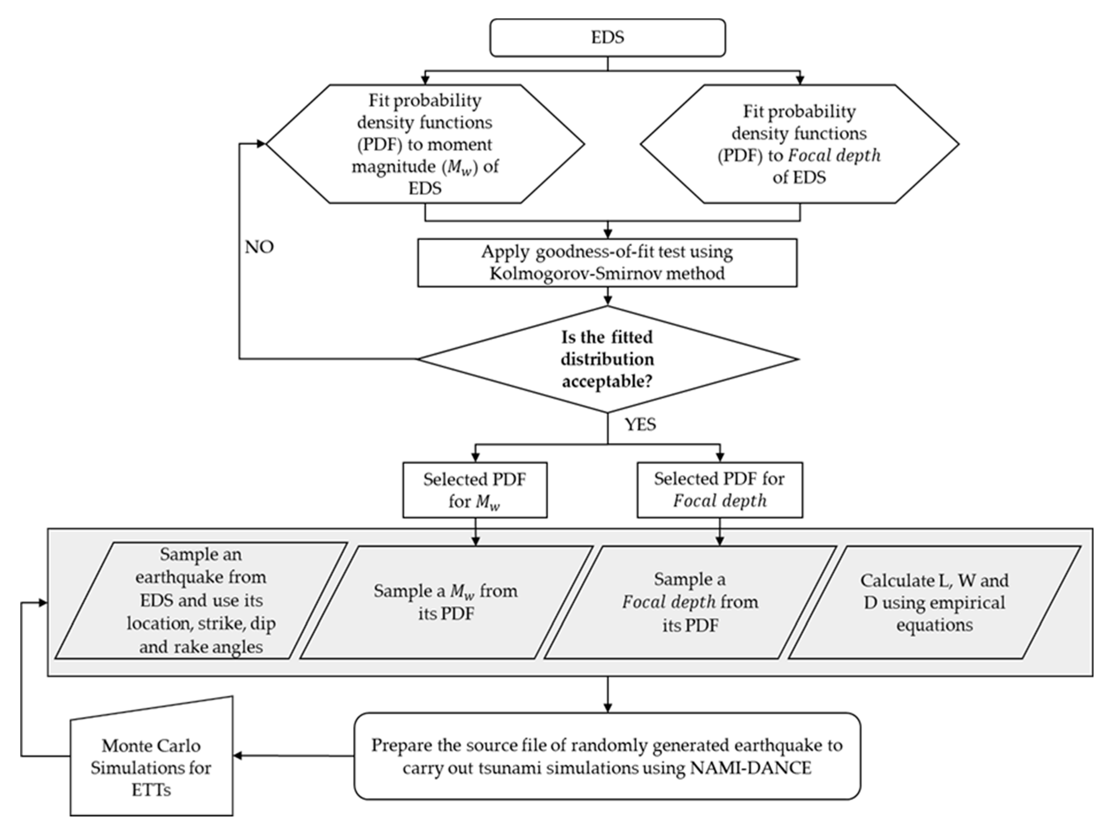
ETT simulations are conducted using NAMI-DANCE software [
30]. To include potential SLR effects, the bathymetry of Mediterranean Sea is updated for each future simulation year (i.e., 2020, 2040, 2060, 2080 and 2100) based on SLR estimates and ETT risks are calculated using the updated bathymetries. Results of the simulations show that the contribution of the SLR related to climate change to ETTs depends on the coastal topography and increased risk levels are expected when both events are simultaneously considered in risk analysis.
3. Results and Discussions
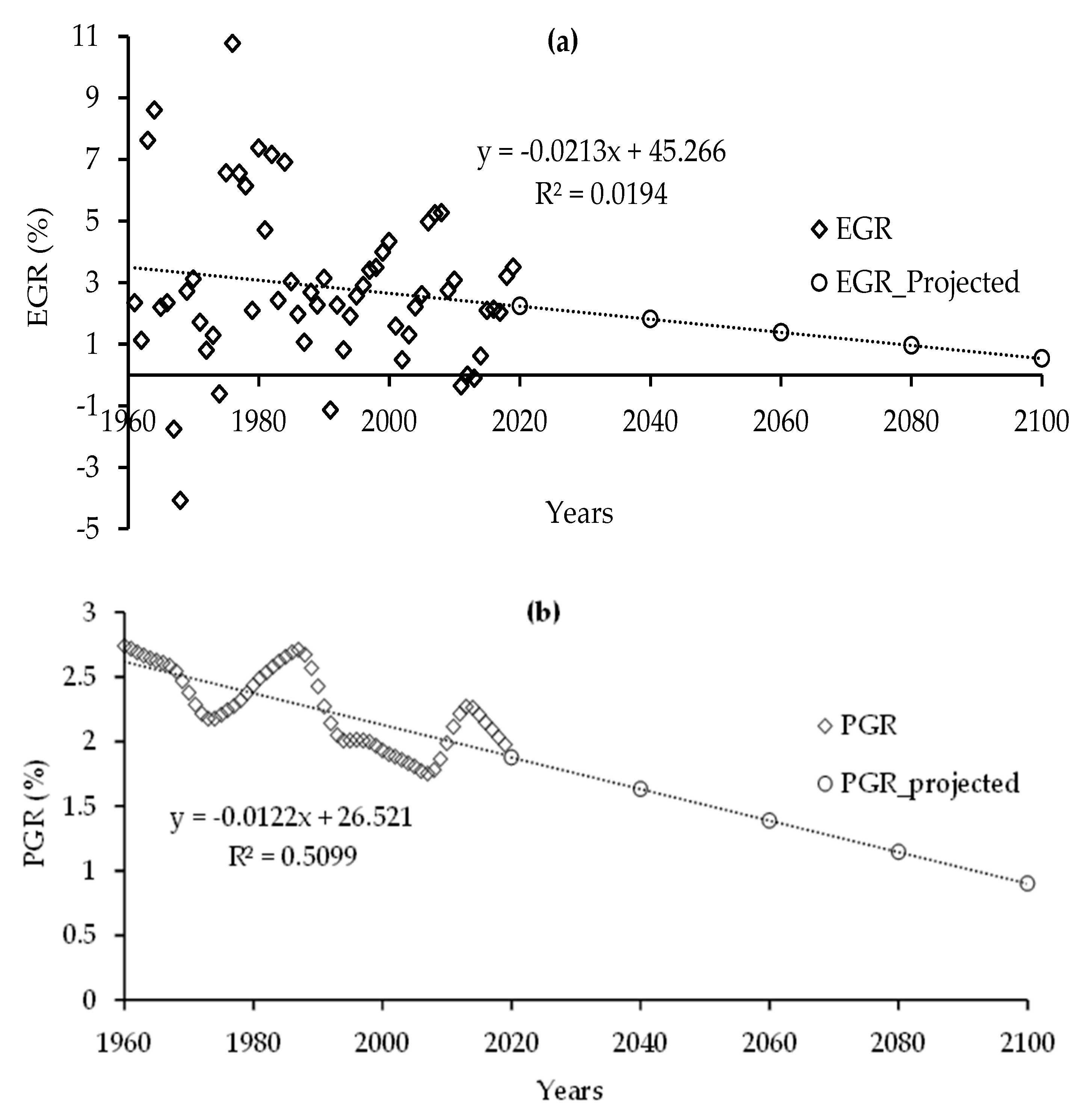
In this study, potential economic and social risks due to ETTs are progressively analyzed over the century with and without considering the climate change induced SLR for Fethiye City Center and the Cairo Agricultural Area. Future economic and social risks presented in this section demonstrate changes in the consequences (i.e., number of people that will be affected and monetary loss that will occur at the selected region for social and economic consequences, respectively) due to ETTs in the presence of SLR together with the projected changes in EGR and PGR. We believe that although local dynamics are ignored (for example country level PGR and EGR values are used) due to very large temporal and spatial domains considered in this study, relative changes in social and economic ETT risks in the presence of SLR are reasonably predicted.
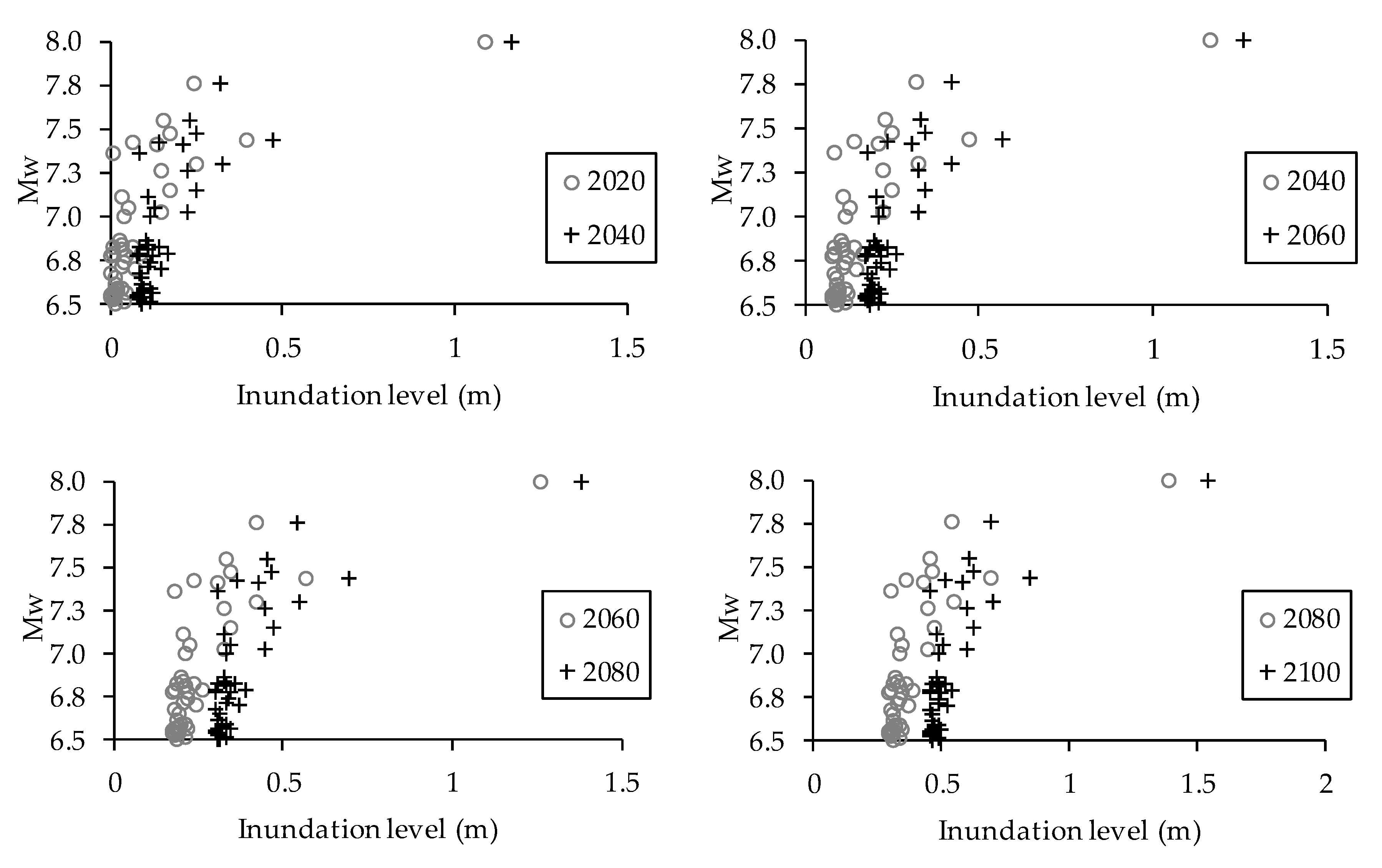
Comparison of inundation levels generated through MC simulations as a function of
for Fethiye City Center and the Cairo Agricultural area with the previous time period are given in
Figure 7 and
Figure 8, respectively. Since the inundation levels obtained from earthquakes with
are negligibly small, they are not shown in
Figure 7 and
Figure 8. It can be observed from the simulation results that inundation levels increase due to SLR both at Fethiye and Cairo.
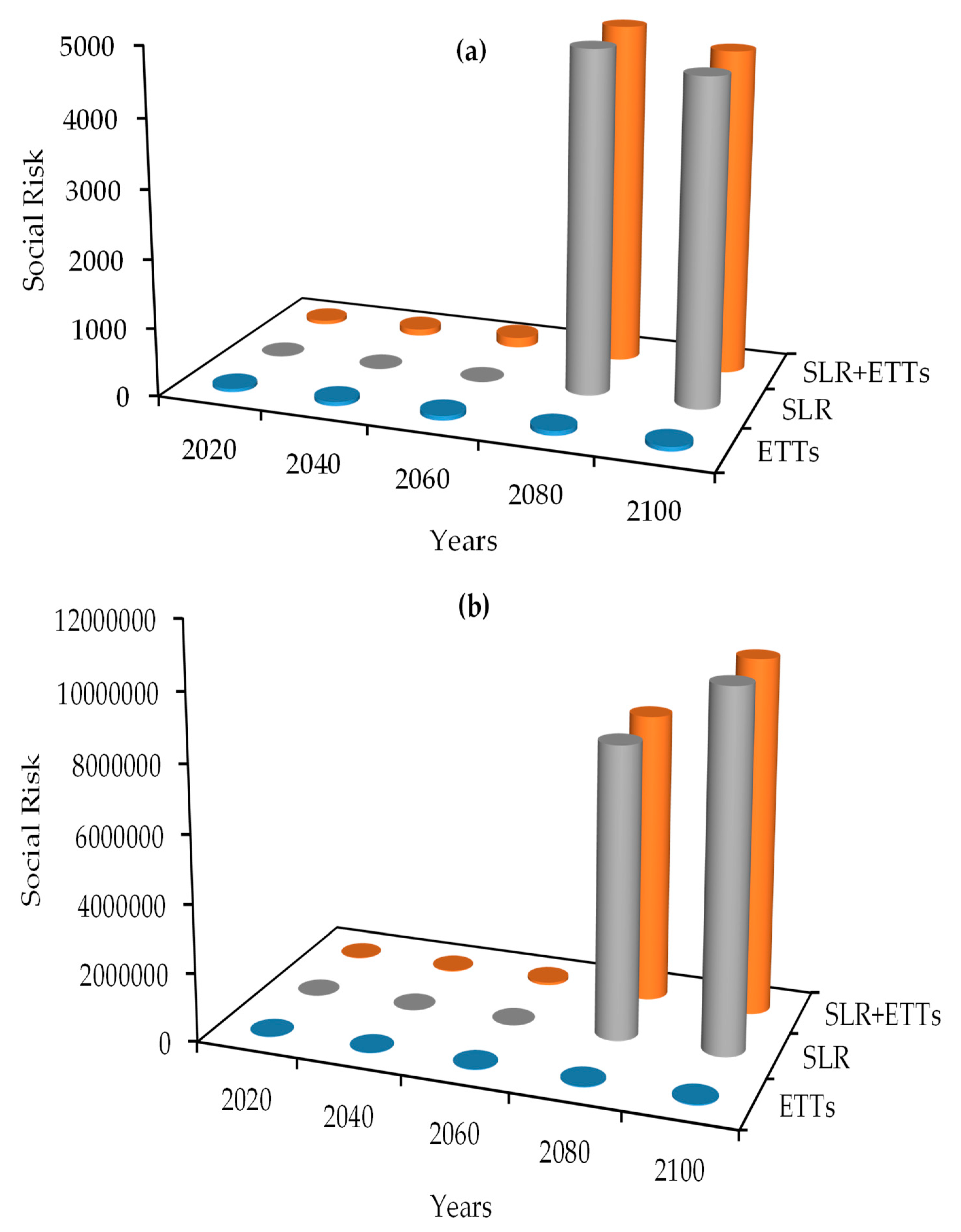
TRA for ETTs, SLR, and ETTs+SLR are performed and the results for Fethiye City Center and the Cairo Agricultural Area are shown in
Figure 9 and
Figure 10, respectively. In
Figure 9a,b, changes in economic risk only for ETTs, demonstrated by blue cylinders, represent the impact of EGR on economic risk. Similarly, in
Figure 10a,b, change in social risk only for ETTs – demonstrated by blue cylinders – represent the impact of PGR on social risk. Economic risks increase for all future years for both selected regions as shown in
Figure 9a,b, respectively. Predicted change in sea level which reaches half a meter by 2100 (
Table 1) has significantly affected economic risk level for both Fethiye City Center and the Cairo Agricultural Area. It should be emphasized that economic risks due to SLR demonstrate the effect of increased inundations at Fethiye and Cairo together with increased maximum damage values estimated using EGRs. Consideration of ETTs and SLR events together leads to a high level of economic risks for both regions and, as can be seen in
Figure 9a,b, the increase in economic risk is mainly due to SLR at both regions, although ETTs effects also increase this risk further.
Social risks due to ETTs and SLR increase for all future years for Fethiye City Center and the Cairo Agricultural Area are shown in
Figure 10a,b, respectively. A minor oscillation in social risk for Fethiye City Center can be observed due to a decrease in the projected PGR for 2080 and 2100, as shown in
Figure 10a.
A comparison of economic risks at Fethiye due to SLR and ETTs+SLR is given in
Table 3 and
Table 4, respectively. For Fethiye, the social risks due to SLR and ETTs+SLR are given in
Table 5 and
Table 6, respectively.
From the results given in
Table 3,
Table 4,
Table 5 and
Table 6 the following observations can be made. Since 2020 is chosen as the base year, ER in 2020 is zero when only SLR is considered and in 2040, ER increases to 30.16 (i.e., almost 3000% increase) (
Table 3). ER due to SLR doubles from 2040 to 2060; then increases tenfold until 2100 (first column of
Table 3). Although numerically smaller ERs occur due to ETTs, the trend is very similar; ER doubles from 2040 to 2060 and increases tenfold until 2100 (first column of
Table 4). Consequently, ER due to SLR+ETTs follows the same behavior while the risk is mainly governed by the SLR effect. Impact of SLR on ER for each investigated future year at Fethiye is given in the last column of
Table 4. For example, in 2040, ER due to ETTs is 4.38 while it is 32.55 due to SLR+ETTs, which corresponds to an increase of over 600%. This value reaches over 1600% in 2100. To realistically evaluate ERs due to ETTs and devise necessary mitigation measures at Fethiye, the effect of SLR has to be taken into consideration.
When only SLR is considered, until 2080, the inundation level at Fethiye does not reach 50 cm (minimum water level which is assumed to cause injury); thus SR is zero (1st column of
Table 5). In 2080 and 2100, inundation level exceeds 50 cm causing SR. But as can be seen from
Figure 6b PGR has a negative slope and around 2080, the population is predicted to start decreasing. Thus, the SR due to SLR decreases slightly from 2080 to 2100 due to the decrease in the population. Trend of PGR causes SR at Fethiye due to ETTs to increase slightly until 2080 and decreases in the last 20 years (first and fourth columns of
Table 6). When SLR is simultaneously considered with ETTs, the SR in each of the investigated future year increases considerably (i.e., 13.86–7075.04% as given in the last column of
Table 6). Relative to risk levels in year 2020 the bi-decadal increase in SR at Fethiye is in the range 22.46–41.95% with ETTs only and with SLR the range is 72.72–8360.87% which again shows that the SLR is adversely affecting the SR in the region.
The economic and social risks due to SLR and ETTs+SLR for Cairo are given in
Table 7 and
Table 8; and
Table 9 and
Table 10, respectively. Comparison of
Table 3 and
Table 7 show that ERs due to SLR at Fethiye and Cairo show similar behavior. By 2100, ER due to SLR at Fethiye reaches around 700 while at Cairo it a little higher, reaching 900. The situation is reversed for ER due to ETTs. While ER due to ETTs reach around 25 at Cairo, it exceeds 40 at Fethiye (first columns of
Table 4 and
Table 8). Since ER is governed by the SLR effects, comparison of ERs due to ETTs in the presence of SLR (ETTs+SLR) show similar behavior and combined ER for Fethiye and Cairo will become around 700 and 900, respectively (second columns of
Table 4 and
Table 8). On the other hand, SR due to both SLR and ETTs at Cairo are much higher than those observed at Fethiye. By 2100, SR due to SLR is around 4700 at Fethiye while it reaches over ten million. Similar to ER, since SR is governed by SLR, combined social risks (ETTs+SLR) are similar to those obtained for SLR.
From the results given in
Table 7,
Table 8,
Table 9 and
Table 10 the following observations can be made. The change in ER due to SLR at Cairo is in the range 0.00–85,669.62% (last column of
Table 7). This is a flat land and the risk level is mainly a function of SLR and flat topography. ER due to SLR increases less than 40% from 2040 to 2060, then increases six-fold until 2100 (first column of
Table 7). Numerically smaller ERs occur due to ETTs and although the trend is very similar from 2040 to 2060, the increase until 2100 is less than twofold (first column of
Table 8). Since numerical values of ERs due to SLR are much larger than those due to ETTs, ER due to SLR+ETTs is mainly governed by the SLR effect at Cairo and ETT effects are minor. Relative to risk levels in year 2020, the bi-decadal economic risk for ETTs only, at Cairo is in the range 49.07–198.45% and with SLR risk level fluctuates in the range 1219.04–10,528.60% (6th and 7th columns of
Table 8, respectively). This again indicates that SLR effects on ER are larger than those of ETT effects. The other reason for minor ETT effects is the distance between the main earthquake zone and the Cairo Agricultural Center region. This distance was very small for the Fethiye region, which amplified the ETTs effects of risk. The bi-decadal ER for SLR+ETTs at Cairo fluctuates in the range of 18.57–1219.04% while for only ETTs the range is 15.85–49.07%. Topography of the site is the influencing factor at Cairo and inundated agricultural land increases significantly due to SLR.
Similar to Fethiye, for Cairo, the inundation level does not exceed 50 cm until 2080 causing no SR due to only SLR (1st column of
Table 9). In 2080 and 2100, inundation level exceeds 50 cm causing SR. As shown in
Figure 7b, although the PGR has a negative slope for Cairo, the population will keep on increasing till 2100 and the SR due to SLR increases as well. Again due to the PGR trend, the SR due to ETTs increases with decreasing rates (2nd and 4th columns of
Table 10). Relative to risk levels in year 2020, the increase in bi-decadal SR with SLR+ETTs at Cairo is extremely high (i.e., 90.88–90496.08% as given in the 7th column of
Table 10), while it is much lower for only ETTs (i.e., 41.45–199.95% as given in the 6th column of
Table 10). When SLR is considered, the SR in each of the investigated future year increases considerably (i.e., 34.95–30,104.16% as given in the last column of
Table 10). This outcome supports increased inundation levels due to topography effects.
4. Conclusions
Studies on climate change indicate that SLR will be experienced in the Mediterranean in the future. Thus studying effects of SLR on the consequences of natural hazards such as ETTs is important. In this study, a comprehensive analysis is conducted for the progressive risk evaluation of ETT hazards in the Eastern Mediterranean Sea in the presence of SLR. ETT simulations are conducted with NAMI-DANCE software using updated bathymetries according to predicted SLRs for future years.
Climate change related SLR and potential ETTs are analyzed simultaneously to evaluate coastal risks at Fethiye City Center and the Cairo Agricultural Area. Results show that majority of both economic and social risks occur due to SLR. Thus, for realistic estimations of risks, ETTs have to be evaluated together with SLR.
Results of the simulations show that ER due to ETTs at Fethiye and Cairo are not the same. The Fethiye region, due to its proximity to the major earthquake zone in the Eastern Mediterranean is affected more from ETTs (1676% increase in ER by 2100 relative to 2020) compared to Cairo. The increase in ER due to ETTs by 2100 at Cairo is less than 200% relative to 2020.
The interesting outcome is that as the SLR increases over the years both economic and social risks drastically increase at the Cairo site due to the flat topography of the region and relatively wider regions being inundated over the years. Although the effect of SLR at the Fethiye site is similar, it is not as pronounced.
Social risk level decreases due to SLR and SLR+ETTs for Fethiye City Center due to a decrease in PGR from 2080 to 2100. However, relative to 2020, SR due to SLR+ETTs at Fethiye and Cairo increases almost 90 and 900 fold, respectively. In conclusion, SLR effects extremely influence the economic and social risks at both sites. But this influence does not show the same trend at both sites. Topography of the region, proximity to the earthquake zones, economic growth rates, and population levels are other factors that need to be considered in this analysis, as is done in this study.


