A Waterbody Typology Derived from Catchment Controls Using Self-Organising Maps


 ,
,
Abstract
1. Introduction
1.1. Approaches to Typology Creation in River Research
1.2. Research Design Utilising National Datasets and Machine Learning
2. Data and Methods
2.1. Catchment Characteristics Data
2.2. Self-Organising Maps (SOMs)
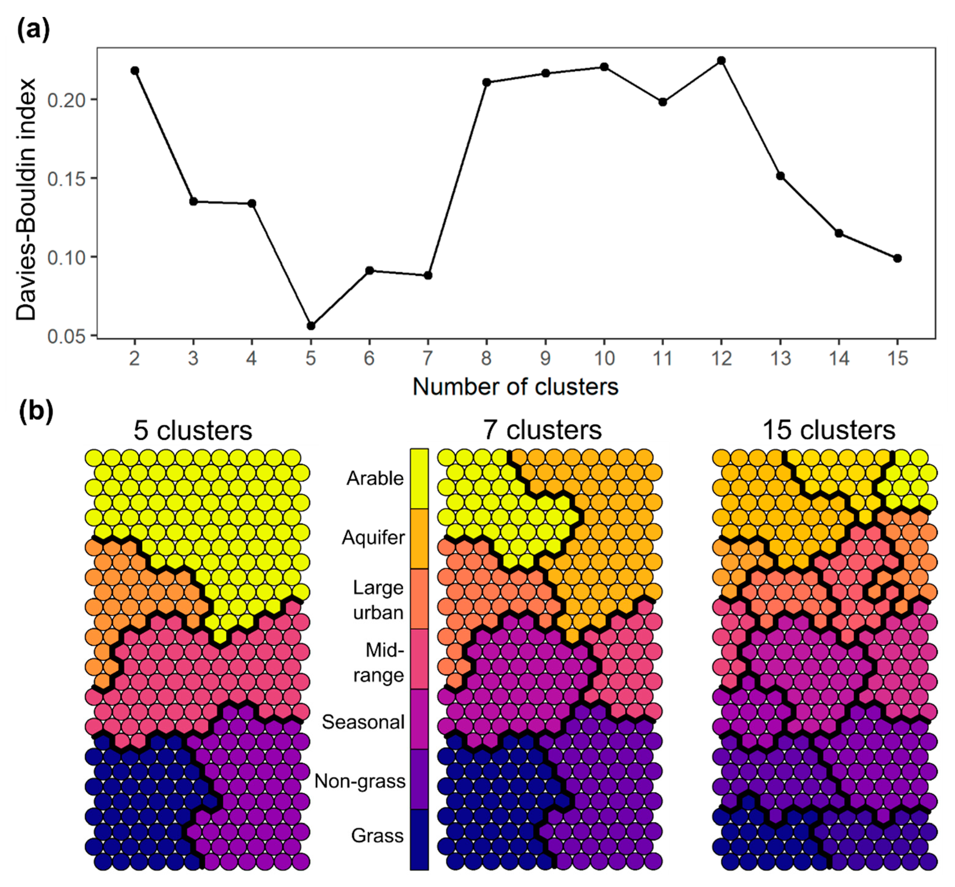
2.3. Cluster Analysis
2.4. Evaluating the Typology with River Habitat Surveys
3. Results
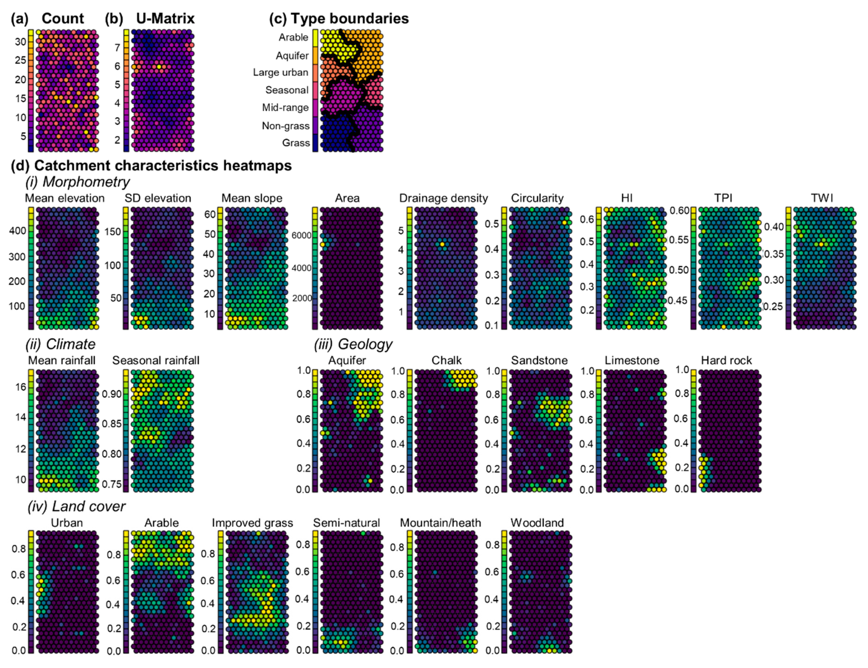
3.1. Interpreting SOM Outputs
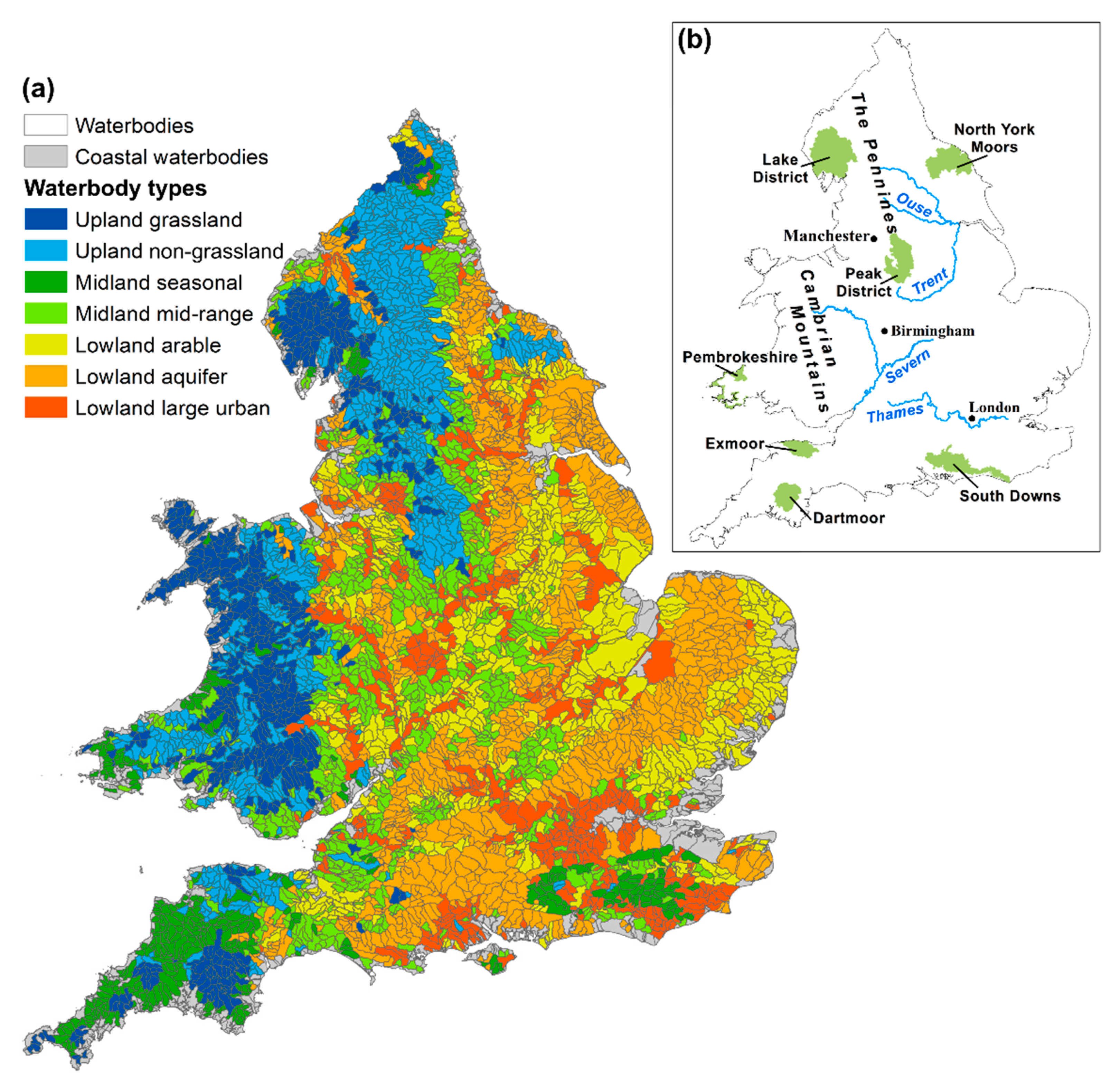
3.2. The Waterbody Typology
3.2.1. Upland Waterbody Types
3.2.2. Midland Waterbody Types
3.2.3. Lowland Waterbody Types
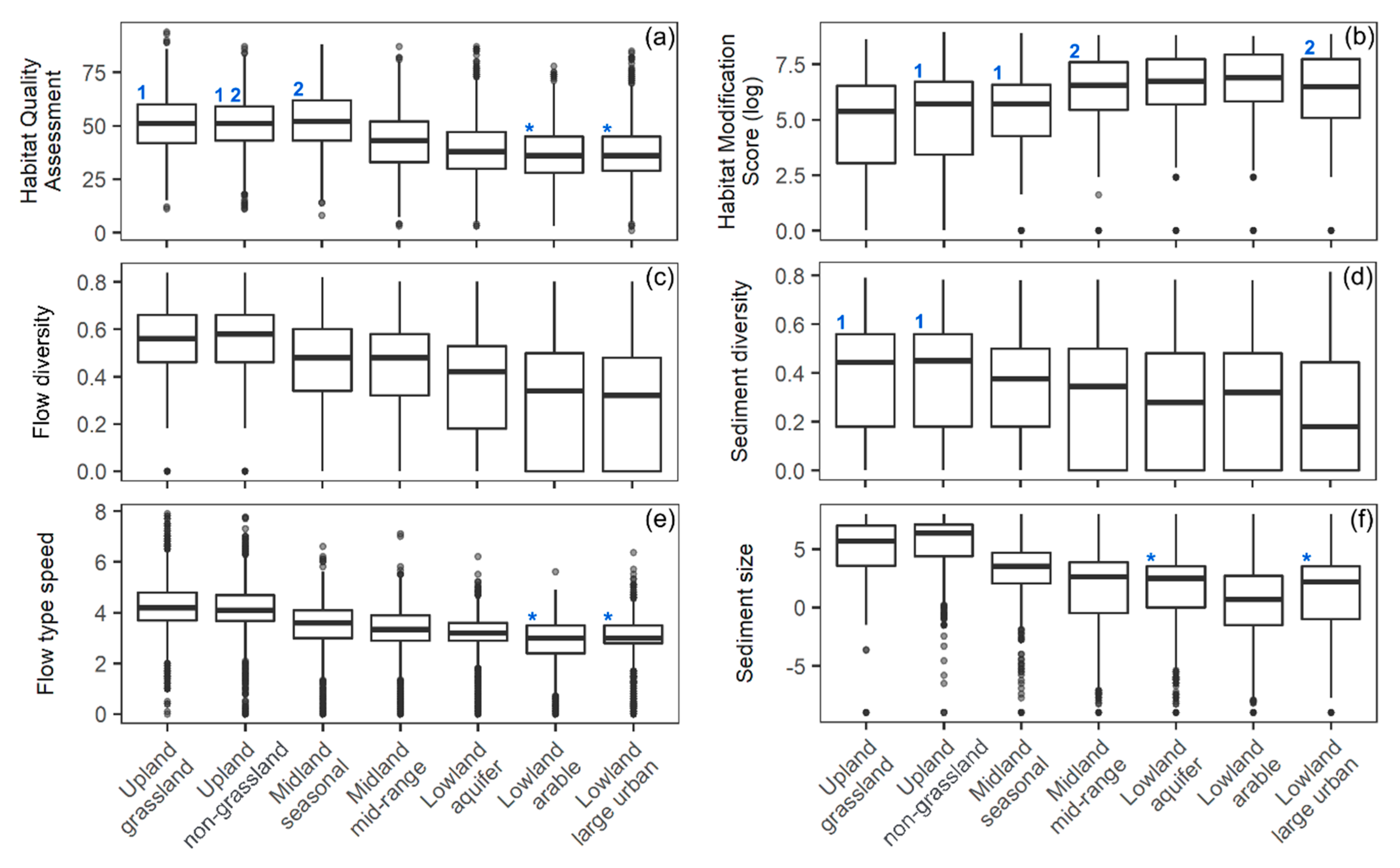
3.3. River Habitat Differentiation between Types
4. Discussion
4.1. A Practical and Applicable Typology of Catchment Controls for Waterbodies in England and Wales
4.2. Critique of the Typology
4.3. Gradients and Anomalies in Waterbody Types and Reach Responses
4.3.1. Upland-Lowland Gradient
4.3.2. Heterogeneity Gradient
4.3.3. Anthropogenic Consistencies and Anomalies
5. Conclusions
Author Contributions
Funding
Acknowledgments
Conflicts of Interest
Appendix A

References
- Frissell, C.A.; Liss, W.J.; Warren, C.E.; Hurley, M.D. A hierarchical framework stream habitat classification. Environ. Manag. 1986, 10, 199–214. [Google Scholar] [CrossRef]
- Brierley, G.; Fryirs, K. River styles, a geomorphic approach to catchment characterization: Implications for river rehabilitation in Bega Catchment, New South Wales, Australia. Environ. Manag. 2000, 25, 661–679. [Google Scholar] [CrossRef]
- Kondolf, G.M.; Montgomery, D.R.; Piégay, H.; Schmitt, L. Geomorphic classification of rivers and streams. In Tools in Fluv. Geomorphol; Kondolf, G.M., Piégay, H., Eds.; Wiley: Chichester, UK, 2003; pp. 171–204. [Google Scholar]
- Hynes, H.B.N. The stream and its valley. Edgardo Baldi Meml. Lect. SIL Proc. 1975, 19, 1–15. [Google Scholar] [CrossRef]
- Gurnell, A.M.; Rinaldi, M.; Belletti, B.; Bizzi, S.; Blamauer, B.; Braca, G.; Buijse, A.D.; Bussettini, M.; Camenen, B.; Comiti, F.; et al. A multi-scale hierarchical framework for developing understanding of river behaviour to support river management. Aquat. Sci. 2016, 78, 1–16. [Google Scholar] [CrossRef]
- Downs, P.W.; Gregory, K.J. River Channel Management: Towards Sustainable Catchment Hydrosystems; Routledge: New York, NY, USA, 2004; ISBN 9780340759691. [Google Scholar]
- Beechie, T.J.; Sear, D.A.; Olden, J.D.; Pess, G.R.; Buffington, J.M.; Moir, H.; Roni, P.; Pollock, M.M. Process-based principles for restoring river ecosystems. BioScience 2010, 60, 209–222. [Google Scholar] [CrossRef]
- Church, M.; Ferguson, R.I. Morphodynamics: Rivers beyond steady state. Water Resour. Res. 2015, 51, 1883–1897. [Google Scholar] [CrossRef]
- England, J.; Gurnell, A.M. Incorporating catchment to reach scale processes into hydromorphological assessment in the UK. Water Environ. J. 2016, 30, 22–30. [Google Scholar] [CrossRef]
- Allan, J.D. Landcapes and Riverscapes: The influence of land use on stream ecosystems. Annu. Rev. Ecol. 2004, 35, 257–284. [Google Scholar] [CrossRef]
- Rinaldi, M.; Gurnell, A.M.; del Tánago, M.G.; Bussettini, M.; Hendriks, D. Classification of river morphology and hydrology to support management and restoration. Aquat. Sci. 2016, 78, 17–33. [Google Scholar] [CrossRef]
- European Commission Directive 2000/60/EC. Off. J. Eur. Communities 2000, L269, 1–15.
- Acreman, M.; Dunbar, M.; Hannaford, J.; Mountford, O.; Wood, P.; Holmes, N.; Cowx, I.; Noble, R.; Extence, C.; Aldrick, J.; et al. Developing environmental standards for abstractions from UK rivers to implement the EU Water Framework Directive. Hydrol. Sci. J. 2008, 53, 1105–1120. [Google Scholar] [CrossRef]
- Naura, M.; Clark, M.J.; Sear, D.A.; Atkinson, P.M.; Hornby, D.D.; Kemp, P.; England, J.; Peirson, G.; Bromley, C.; Carter, M.G. Mapping habitat indices across river networks using spatial statistical modelling of River Habitat Survey data. Ecol. Indic. 2016, 66, 20–29. [Google Scholar] [CrossRef]
- Tadaki, M.; Brierley, G.; Cullum, C. River classification: Theory, practice, politics. Wiley Interdiscip. Rev. Water 2014, 1, 349–367. [Google Scholar] [CrossRef]
- Wright, J.F.; Moss, D.; Armitage, P.D.; Furse, M.T. A preliminary classification of running-water sites in Great Britain based on macro-invertebrate species and the prediction of community type using environmental data. Freshw. Biol. 1984, 14, 221–256. [Google Scholar] [CrossRef]
- Olden, J.D.; Kennard, M.J.; Pusey, B.J. A Framework for hydrologic classification with a review of methodologies and applications in ecohydrology. Ecohydrology 2012, 5, 503–518. [Google Scholar] [CrossRef]
- Rosgen, D.L. A Stream Classification System; Technical Report for Riparian Ecosystem and Their Management: Reconciling Conflicting Uses; First North American Riparian Conference; USDA Forest Service: Washington, DC, USA, 1985.
- Jeffers, J.N.R. Characterization of river habitats and prediction of habitat features using ordination techniques. Aquat. Conserv. Mar. Freshw. Ecosyst. 1998, 8, 529–540. [Google Scholar] [CrossRef]
- UKTAG. Guidance on Typology for Rivers for Scotland, England and Wales; UK Technical Advisory Group Water Framework Directive Work Progress Task 2a; Typology Rivers 2003; pp. 1–4. Available online: http://www.wfduk.org › files › Media › Rivers typology_Final_050603 (accessed on 11 May 2016).
- Schumm, S.A.; Lichty, R.W. Time, space, and causality in geomorphology. Am. J. Sci. 1965, 263, 110–119. [Google Scholar] [CrossRef]
- Naura, M. (The River Restoration Centre, Cranfield, UK); Walker, J. (Environment Agency, Lancashire, UK); Maas, G. (Environment Agency, Cheshire, UK). Derivation and Comparison of Various Typologies for the WFD; UK Technical. Advisory Group Paper Number: RTT. 2003. Personal communication, 1 October 2018. [Google Scholar]
- Holmes, N.T.H.; Boon, P.J.; Rowell, T.A. A revised classification system for British rivers based on their aquatic plant communities. Aquat. Conserv. Mar. Freshw. Ecosyst. 1998, 8, 555–578. [Google Scholar] [CrossRef]
- Bizzi, S.; Lerner, D.N. Characterizing physical habitats in rivers using map-derived drivers of fluvial geomorphic processes. Geomorphology 2012, 169, 64–73. [Google Scholar] [CrossRef]
- Liakos, K.G.; Busato, P.; Moshou, D.; Pearson, S.; Bochtis, D. Machine learning in agriculture: A review. Sensors 2018, 18, 2674. [Google Scholar] [CrossRef]
- Feld, C.K.; Segurado, P.; Gutiérrez-Cánovas, C. Analysing the impact of multiple stressors in aquatic biomonitoring data: A ‘cookbook’ with applications in R. Sci. Total Environ. 2016, 573, 1320–1339. [Google Scholar] [CrossRef] [PubMed]
- Kohonen, T. Self-organized formation of topologically correct feature maps. Biol. Cybern. 1982, 43, 59–69. [Google Scholar] [CrossRef]
- Astel, A.; Tsakovski, S.; Barbieri, P.; Simeonov, V. Comparison of self-organizing maps classification approach with cluster and principal components analysis for large environmental data sets. Water Res. 2007, 41, 4566–4578. [Google Scholar] [CrossRef] [PubMed]
- Walley, W.J.; Martin, R.W.; O’Connor, M.A. Self-Organising Maps for the classification and diagnosis of river quality from biological and environmental data. In IFIP—The International Federation for Information Processing; Springer: Boston, MA, USA, 1999; pp. 27–41. [Google Scholar]
- Morris, D.G.; Flavin, R.W. A digital terrain model for hydrology. In Proceedings of the 4th International Symposium of Spatial Data Handling, Zürich, Switzerland, 23–27 July 1990; pp. 250–262. [Google Scholar]
- Morris, D.G.; Flavin, R.W. Sub-Set of UK 50 m by 50 m Hydrological Digital Terrain Model Grids; NERC, Institute of Hydrology: Wallingford, CT, USA, 1994. [Google Scholar]
- CEH Integrated Hydrological Digital Terrain Model. Available online: https://www.ceh.ac.uk/services/integrated-hydrological-digital-terrain-model (accessed on 2 February 2016).
- Moore, R.V.; Morris, D.G.; Flavin, R.W. Sub-Set of UK Digital 1:50,000 Scale River Centreline Network; NERC, Institute of Hydrology: Wallingford, CT, USA, 1994. [Google Scholar]
- CEH 1:50,000 Digital River Network. Available online: https://www.ceh.ac.uk/services/150000-watercourse-network (accessed on 2 February 2016).
- Perry, M.; Hollis, D. The generation of monthly gridded datasets for a range of climatic variables over the UK. Int. J. Climatol. 2005, 25, 1041–1054. [Google Scholar] [CrossRef]
- Met Office; Hollis, D.; McCarthy, M. UKCP09: Met Office Gridded and Regional Land Surface Climate Observation Datasets; Centre for Environmental Data Analysis. 2017. Available online: https://catalogue.ceda.ac.uk/uuid/319b3f878c7d4cbfbdb356e19d8061d6 (accessed on 10 April 2018).
- BGS Bedrock Geology 1:625,000. Available online: http://www.bgs.ac.uk/products/digitalmaps/DiGMapGB_50.html (accessed on 2 March 2016).
- Harvey, G.L.; Gurnell, A.M.; Clifford, N.J. Characterisation of river reaches: The influence of rock type. Catena 2008, 76, 78–88. [Google Scholar] [CrossRef]
- Vaughan, I.P.; Merrix-Jones, F.L.; Constantine, J.A. Successful predictions of river characteristics across England and Wales based on ordination. Geomorphology 2013, 194, 121–131. [Google Scholar] [CrossRef]
- CEH Morton, R.D.; Rowland, C.S.; Wood, C.M.; Meek, L.; Marston, C.G.; Smith, G.M. Land Cover Map 2007 (25m raster, GB) v1.2. Available online: https://www.ceh.ac.uk/services/land-cover-map-2007 (accessed on 29 February 2016).
- Knighton, D. Fluvial Forms and Processes: A New Perspective, 3rd ed.; Routledge: London, UK, 1998. [Google Scholar]
- Rice, S.P.; Church, M. Grain size along two gravel-bed rivers: Statistical variation, spatial pattern and sedimentary links. Earth Surf. Process. Landf. 1998, 23, 345–363. [Google Scholar] [CrossRef]
- Weiss, A.D. Topographic position and landforms analysis. In Proceedings of the ESRI User Conference, San Diego, CA, USA, 9–13 July 2001. [Google Scholar]
- Benda, L.; Poff, N.L.; Miller, D.; Dunne, T.; Reeves, G.; Pess, G.; Pollock, M. The network dynamics hypothesis: How channel networks structure riverine habitats. BioScience 2004, 54, 413–427. [Google Scholar] [CrossRef]
- Beven, K.J.; Kirkby, M.J. A physically based, variable contributing area model of basin hydrology. Hydrol. Sci. Bull. 1979, 24, 43–69. [Google Scholar] [CrossRef]
- Willgoose, C.; Hancock, G. Revisiting the hypsometric curve as an indicator of form and process in transport-limited catchment. Earth Surf. Process. Landf. 1998, 23, 611–623. [Google Scholar] [CrossRef]
- Miller, V.C. A Quantitative Geomorphic Study of Drainage Basin Characteristics in the Clinch Mountain Area, Virginia and Tennessee 2; Columbia University: New York, NY, USA, 1953. [Google Scholar]
- Gregory, K.J.; Walling, D.E. Drainage Basin Form and Process; Wiley: Chichester, UK, 1973. [Google Scholar]
- Singh, V.P. Effect of spatial and temporal variability in rainfall and watershed characteristics on stream flow hydrograph. Hydrol. Process. 1997, 11, 1649–1669. [Google Scholar] [CrossRef]
- Flores, A.N.; Bledsoe, B.P.; Cuhaciyan, C.O.; Wohl, E.E. Channel-reach morphology dependence on energy, scale, and hydroclimatic processes with implications for prediction using geospatial data. Water Resour. Res. 2006, 42, 1–15. [Google Scholar] [CrossRef]
- Holmes, M.G.R.; Young, A.R.; Gustard, A.; Grew, R. A region of influence approach to predicting flow duration curves within unguaged catchments. Hydrol. Earth Syst. Sci. 2002, 6, 721–731. [Google Scholar] [CrossRef]
- Sear, D.A.; Newson, M.D.; Thorne, C.R. Guidebook of Applied Fluvial Geomorphology; Environment Agency R&D Dissemination Centre: Swindon, UK, 2003. [Google Scholar]
- Dadson, S.J.; Hall, J.W.; Murgatroyd, A.; Acreman, M.; Bates, P.; Beven, K.; Holden, J.; Holman, I.P.; Lane, S.N.; Connell, E.O.; et al. A restatement of the natural science evidence concerning flood management in the UK. Proc. R. Soc. A 2017, 473. [Google Scholar] [CrossRef] [PubMed]
- Wharton, G.; Mohajeri, S.H.; Righetti, M. The pernicious problem of streambed colmation: A multi-disciplinary reflection on the mechanisms, causes, impacts, and management challenges. Wiley Interdiscip. Rev. Water 2017, 4, e1231. [Google Scholar] [CrossRef]
- Kohonen, T. Self-Organizing Maps, 3rd ed.; Springer: Berlin, Germany, 2001; ISBN 9783642569272. [Google Scholar]
- Park, Y.S.; Tison, J.; Lek, S.; Giraudel, J.L.; Coste, M.; Delmas, F. Application of a self-organizing map to select representative species in multivariate analysis: A case study determining diatom distribution patterns across France. Ecol. Inform. 2006, 1, 247–257. [Google Scholar] [CrossRef]
- Vesanto, J. Neural network tool for data mining: SOM toolbox. In Proceedings of the Symposium on Tool Environments and Development Methods for Intelligent Systems, Helsinki, Finland, 18 April 2000; pp. 184–196. [Google Scholar]
- Wehrens, R.; Kruisselbrink, J. Supervised and unsupervised Self-Organising Maps. In Packag. “Kohonen” Version 3.0.7. 2018. Available online: https://cran.r-project.org/web/packages/kohonen/kohonen.pdf (accessed on 4 September 2018).
- R Core Team. A Language and Environment for Statistical Computing; R Core Team: Vienna, Austria, 2018. [Google Scholar]
- Heasley, E.L. Waterbody_Typology Version v1.0.0, Zenodo. 2019. Available online: http://doi.org/10.5281/zenodo.3558120.
- Davies, D.L.; Bouldin, D.W. A cluster separation measure. IEEE Trans. Pattern Anal. Mach. Learn. Intell. 1979, 1, 224–227. [Google Scholar] [CrossRef]
- Raven, P.J.; Fox, P.; Everard, M.; Holmes, N.T.H.; Dawson, F.H. River Habitat Survey: A new system for classifying rivers according to their habitat quality. In Freshwater Quality: Defining the Indefinable? Boon, P.J., Howell, D.L., Eds.; The Stationery Office: Edinburgh, Scotland, UK, 1996; pp. 215–234. [Google Scholar]
- CEN. Water Quality—Guidance Standard for Assessing the Hydromorphological Features of Rivers; European Commission for Standardization: Brussels, Belgium, 2004. [Google Scholar]
- Belletti, B.; Rinaldi, M.; Buijse, A.D.; Gurnell, A.M.; Mosselman, E. A review of assessment methods for river hydromorphology. Environ. Earth Sci. 2015, 73, 2079–2100. [Google Scholar] [CrossRef]
- Harvey, G.L.; Clifford, N.J.; Gurnell, A.M. Towards an ecologically meaningful classification of the flow biotope for river inventory, rehabilitation, design and appraisal purposes. J. Environ. Manag. 2008, 88, 638–650. [Google Scholar] [CrossRef]
- Raven, P.J.; Holmes, N.T.H.; Dawson, F.H.; Everard, M. Quality assessment using River Habitat Survey data. Aquat. Conserv. Mar. Freshw. Ecosyst. 1998, 8, 477–499. [Google Scholar] [CrossRef]
- Davenport, A.J.; Gurnell, A.M.; Armitage, P.D. Habitat survey and classification of urban rivers. River Res. Appl. 2004, 20, 687–704. [Google Scholar] [CrossRef]
- Emery, J.C.; Gurnell, A.M.; Clifford, N.J.; Petts, G.E. Characteristics and controls of gravel-bed riffles: An analysis of data from the river-habitat survey. Water Environ. J. 2004, 18, 210–216. [Google Scholar] [CrossRef]
- Simpson, E.H. Measurement of diversity. Nature 1949, 163, 688. [Google Scholar] [CrossRef]
- Benjamini, Y.; Hochberg, Y. Controlling the false discovery rate: A practical and powerful approach to multiple testing. J. R. Stat. Soc. Ser. B (Methodological) 1995, 57, 289–300. [Google Scholar] [CrossRef]
- Office for National Statistics. National Parks—Full Extent Boundaries in Great Britain. Available online: http://geoportal.statistics.gov.uk/datasets/national-parks-august-2016-full-extent-boundaries-in-great-britain (accessed on 20 August 2016).
- ASCE. Artificial Neural Networks in hydrology: Preliminary concepts. J. Hydrol. Eng. 2000, 5, 115–123. [Google Scholar] [CrossRef]
- Newson, M.D.; Clark, M.J.; Sear, D.A.; Brookes, A. The geomorphological basis for classifying rivers. Aquat. Conserv. Mar. Freshw. Ecosyst. 1998, 8, 415–430. [Google Scholar] [CrossRef]
- Jusik, S.; Szoszkiewicz, K.; Kupiec, J.M.; Lewin, I.; Samecka-Cymerman, A. Development of comprehensive river typology based on macrophytes in the mountain-lowland gradient of different Central European ecoregions. Hydrobiologia 2015, 745, 241–262. [Google Scholar] [CrossRef]
- Bunn, S.E.; Arthington, A.H. Basic principles and ecological consequences of altered flow regimes for aquatic biodiversity. Environ. Manag. 2002, 30, 492–507. [Google Scholar] [CrossRef]
- Raven, E.K.; Lane, S.N.; Bracken, L.J. Understanding sediment transfer and morphological change for managing upland gravel-bed rivers. Prog. Phys. Geogr. 2010, 34, 23–45. [Google Scholar] [CrossRef]
- Church, M. Geomorphic thresholds in riverine landscapes. Freshw. Biol. 2002, 47, 541–557. [Google Scholar] [CrossRef]
- Vannote, R.; Minshall, G.; Cummins, K.; Sedell, J.; Cushing, C. The River Continuum Concept. Can. J. Fish. Aquat. Sci. 1980, 37, 130–137. [Google Scholar] [CrossRef]
- Gurnell, A.M.; O’Hare, J.M.; O’Hare, M.T.; Dunbar, M.J.; Scarlett, P.M. An exploration of associations between assemblages of aquatic plant morphotypes and channel geomorphological properties within British rivers. Geomorphology 2010, 116, 135–144. [Google Scholar] [CrossRef]
- Downs, P.W.; Gregory, K.J.; Brookes, A. How integrated is river basin management? Environ. Manag. 1991, 15, 299–309. [Google Scholar] [CrossRef]
- Berrie, A.D. The chalk-stream environment. Hydrobiologia 1992, 248, 3–9. [Google Scholar] [CrossRef]
- Poff, N.L.; Allan, J.D.; Bain, M.B.; Karr, J.R.; Prestegaard, K.L.; Richter, B.D.; Sparks, R.E.; Stromberg, J.C. A paradigm for river conservation and restoration. BioScience 1997, 47, 769–784. [Google Scholar] [CrossRef]
- Walsh, C.J.; Roy, A.H.; Feminella, J.W.; Cottingham, P.D.; Groffman, P.M.; Raymond, P.M. The urban stream syndrome: Current knowledge and the search for a cure. J. N. Am. Benthol. Soc. 2005, 24, 706–723. [Google Scholar] [CrossRef]


| Local Controls | Catchment Controls | ||||||||||||||
|---|---|---|---|---|---|---|---|---|---|---|---|---|---|---|---|
| Site altitude | Site slope | Distance to source | Height of source | Channel geometry | Stream power | Discharge | Floodplain width | Elevation | Upstream area | Geology | Climate | Baseflow Index | Morphometry | Land cover | |
| Jeffers [19] | X | X | X | X | |||||||||||
| Holmes et al. [23] | X | X | X | X | |||||||||||
| WFD System A [20] * | X | X | X | ||||||||||||
| Acreman et al. [13] * | X | X | X | ||||||||||||
| Bizzi and Lerner [24] | X | X | X | X | |||||||||||
| This typology * | X | X | X | X | X | X | |||||||||
| Catchment Characteristic | Units | Control on River Functioning |
|---|---|---|
| Morphometry | ||
| Cumulative catchment area | km2 | |
| Mean slope | degrees | |
| Mean elevation | m | |
| Standard deviation elevation | m | |
| Topographic Position Index (TPI) | 0–1 | |
| Topographic Wetness Index (TWI) | 0–1 | |
| Drainage density | km/km2 | |
| Hypsometric Index (HI) | 0–1 | |
| Circularity ratio | 0–1 | |
| Climate | ||
| Mean annual number of days with rain > 1 mm | n | |
| Seasonal rainfall ratio | 0–1 | |
| Geology | ||
| Hard rock | % |
|
| Other limestone | % | |
| Sandstone | % | |
| Chalk | % | |
| Aquifer | % | |
| Land cover | ||
| Woodland | % |
|
| Improved grassland | % | |
| Seminatural grassland | % | |
| Mountain, heath, bog | % | |
| Arable | % | |
| Urban | % |
| Habitat Index | Mean Scores (Range) |
|---|---|
| Summary indices (Overview of reach condition for river quality assessment) | |
| Habitat Quality Assessment (HQA) | 42 (1–94) |
| Habitat Modification Score (HMS) | 1055 (1–7715) |
| Individual habitat indices (Quantify individual components of reach condition that reflect physical habitat) | |
| Flow type diversity | 0.39 (0–0.84) |
| Sediment diversity | 0.30 (0–0.82) |
| Flow type speed | 3.29 (0–7.9) |
| Sediment size | 2.46 (−9–8) |
© 2019 by the authors. Licensee MDPI, Basel, Switzerland. This article is an open access article distributed under the terms and conditions of the Creative Commons Attribution (CC BY) license (http://creativecommons.org/licenses/by/4.0/).
Share and Cite
Heasley, E.L.; Millington, J.D.A.; Clifford, N.J.; Chadwick, M.A. A Waterbody Typology Derived from Catchment Controls Using Self-Organising Maps. Water 2020, 12, 78. https://doi.org/10.3390/w12010078
Heasley EL, Millington JDA, Clifford NJ, Chadwick MA. A Waterbody Typology Derived from Catchment Controls Using Self-Organising Maps. Water. 2020; 12(1):78. https://doi.org/10.3390/w12010078
Chicago/Turabian StyleHeasley, Eleanore L., James D. A. Millington, Nicholas J. Clifford, and Michael A. Chadwick. 2020. "A Waterbody Typology Derived from Catchment Controls Using Self-Organising Maps" Water 12, no. 1: 78. https://doi.org/10.3390/w12010078
APA StyleHeasley, E. L., Millington, J. D. A., Clifford, N. J., & Chadwick, M. A. (2020). A Waterbody Typology Derived from Catchment Controls Using Self-Organising Maps. Water, 12(1), 78. https://doi.org/10.3390/w12010078