Changes in the Dynamics and Nature of Sedimentation in Mill Ponds as an Indicator of Environmental Changes in a Selected Lake Catchment (Chełmińskie Lake District, Poland)


Abstract
1. Introduction
2. Materials and Methods
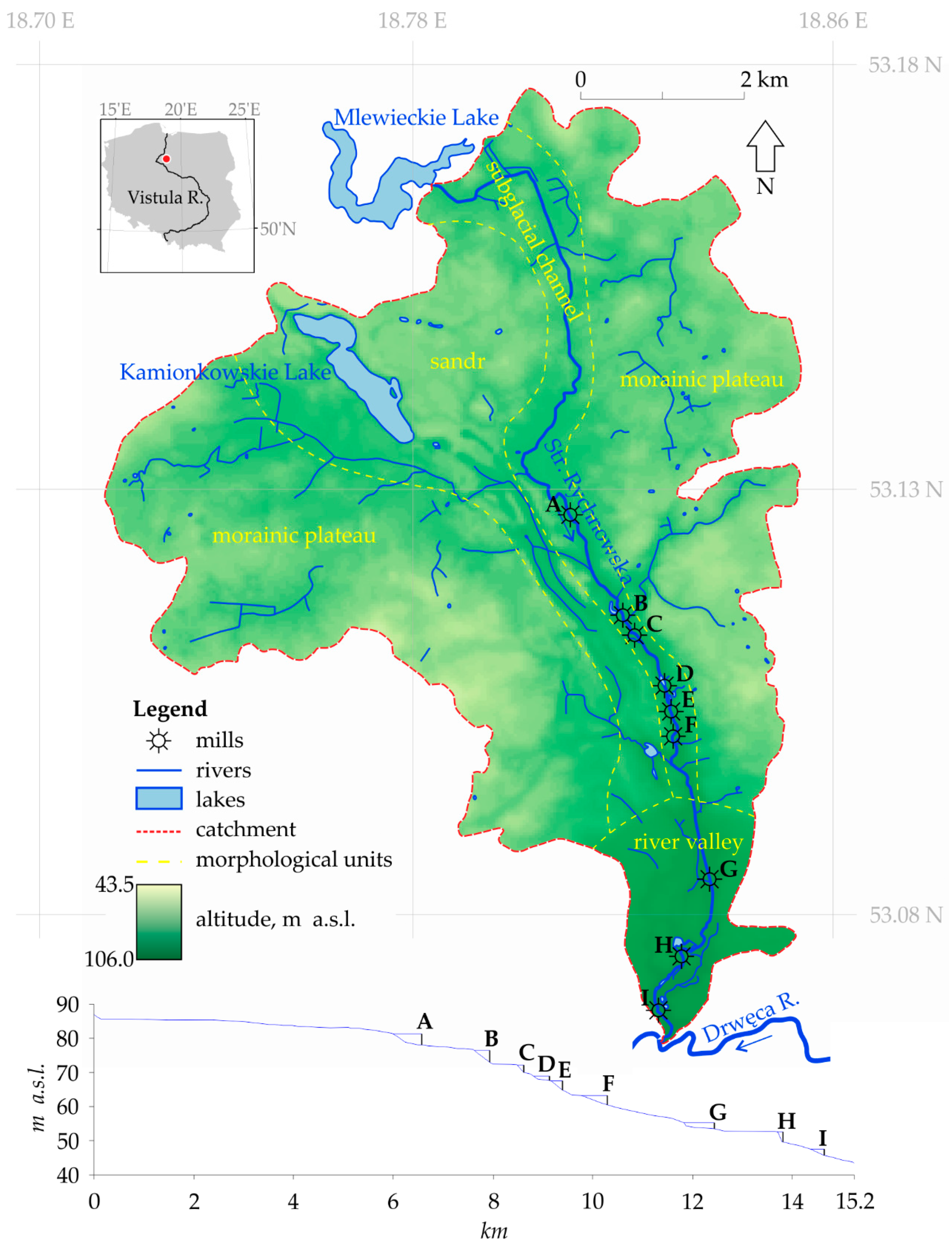
2.1. Study Area
2.2. Struga Rychnowska
2.3. Runoff Conditions
2.4. Methods
3. Results
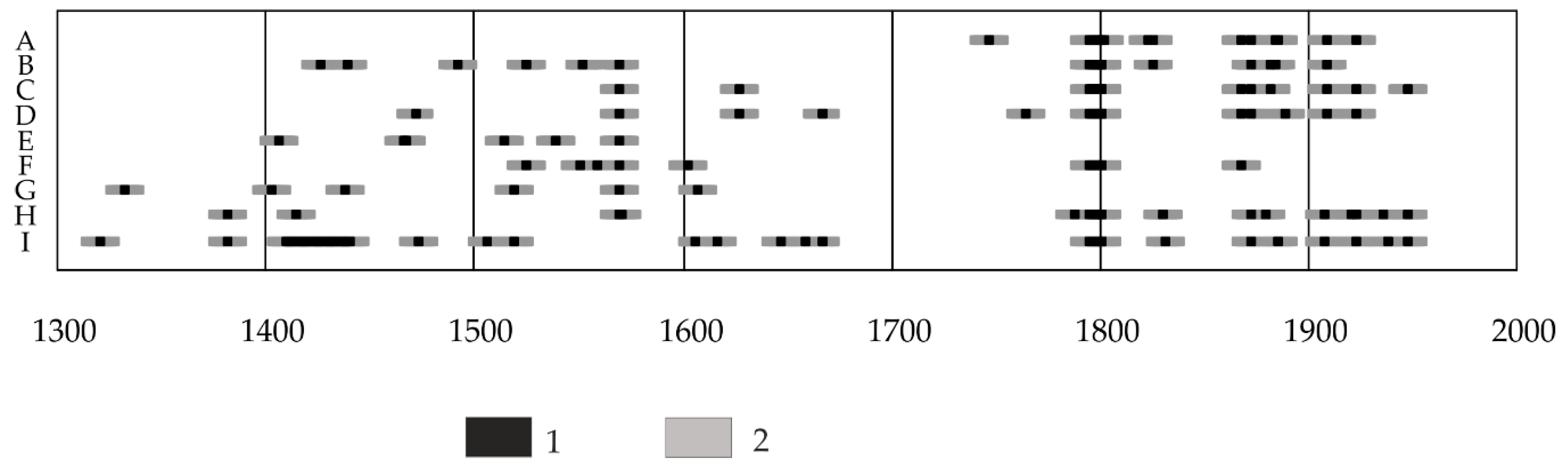
3.1. Construction and Operation of Water Mills in the Struga Rychnowska Catchment
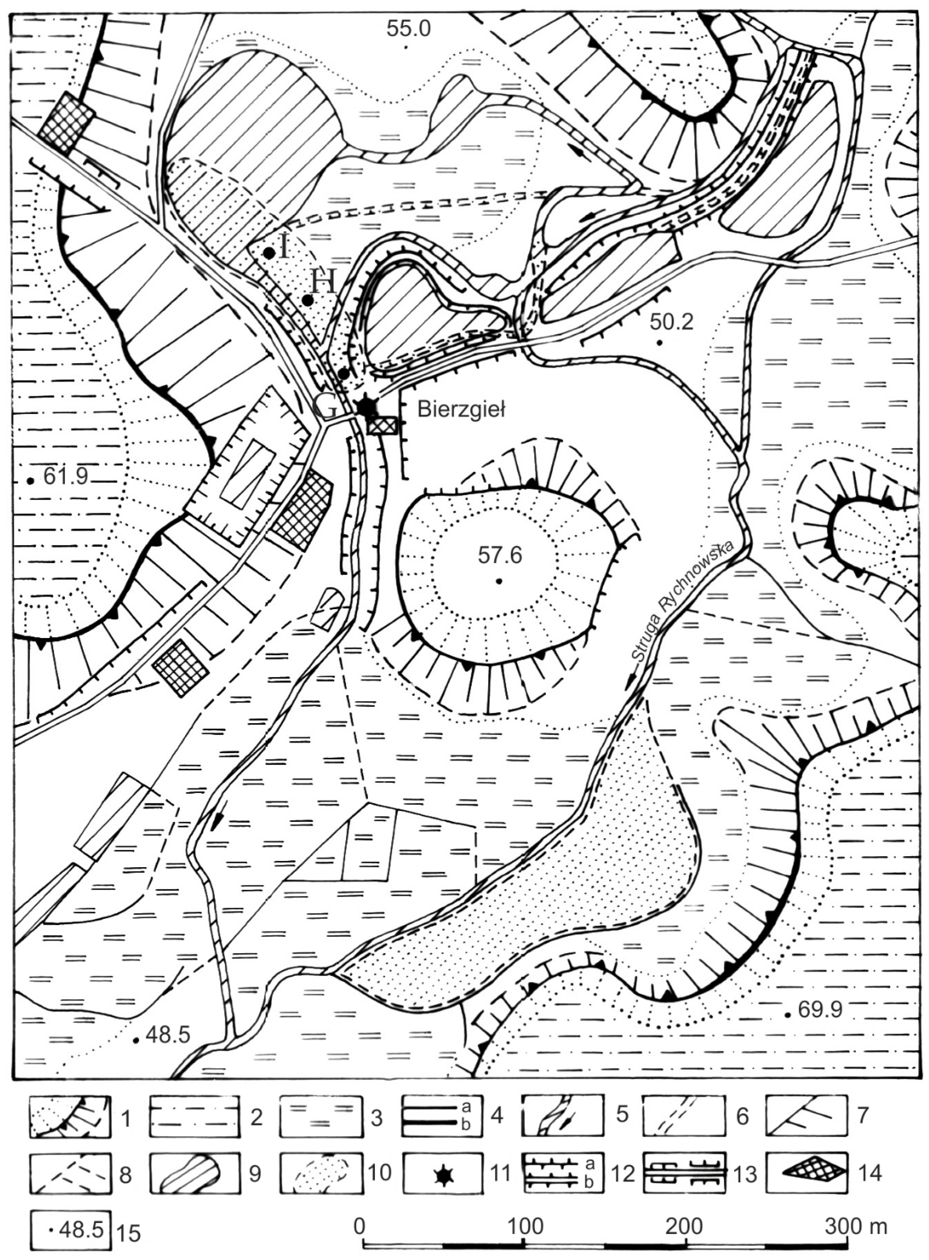
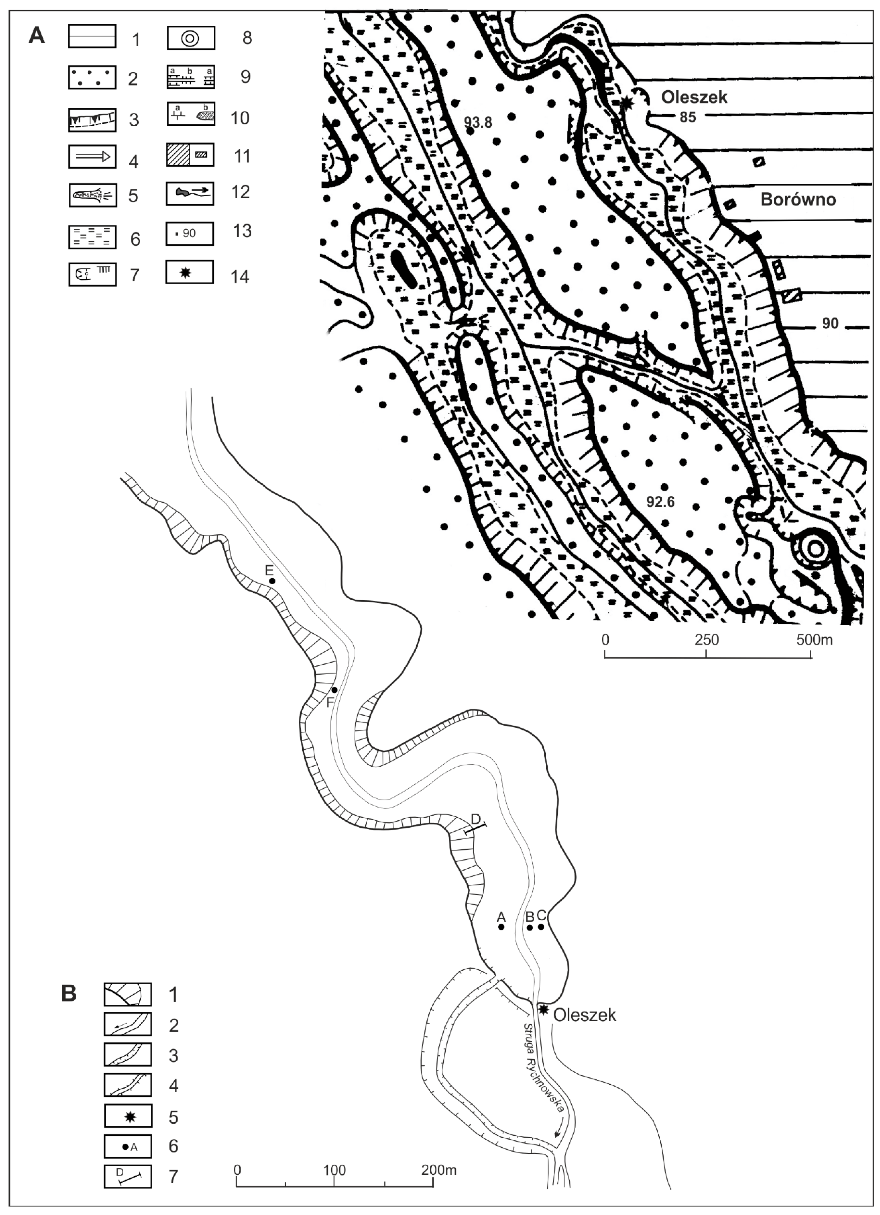
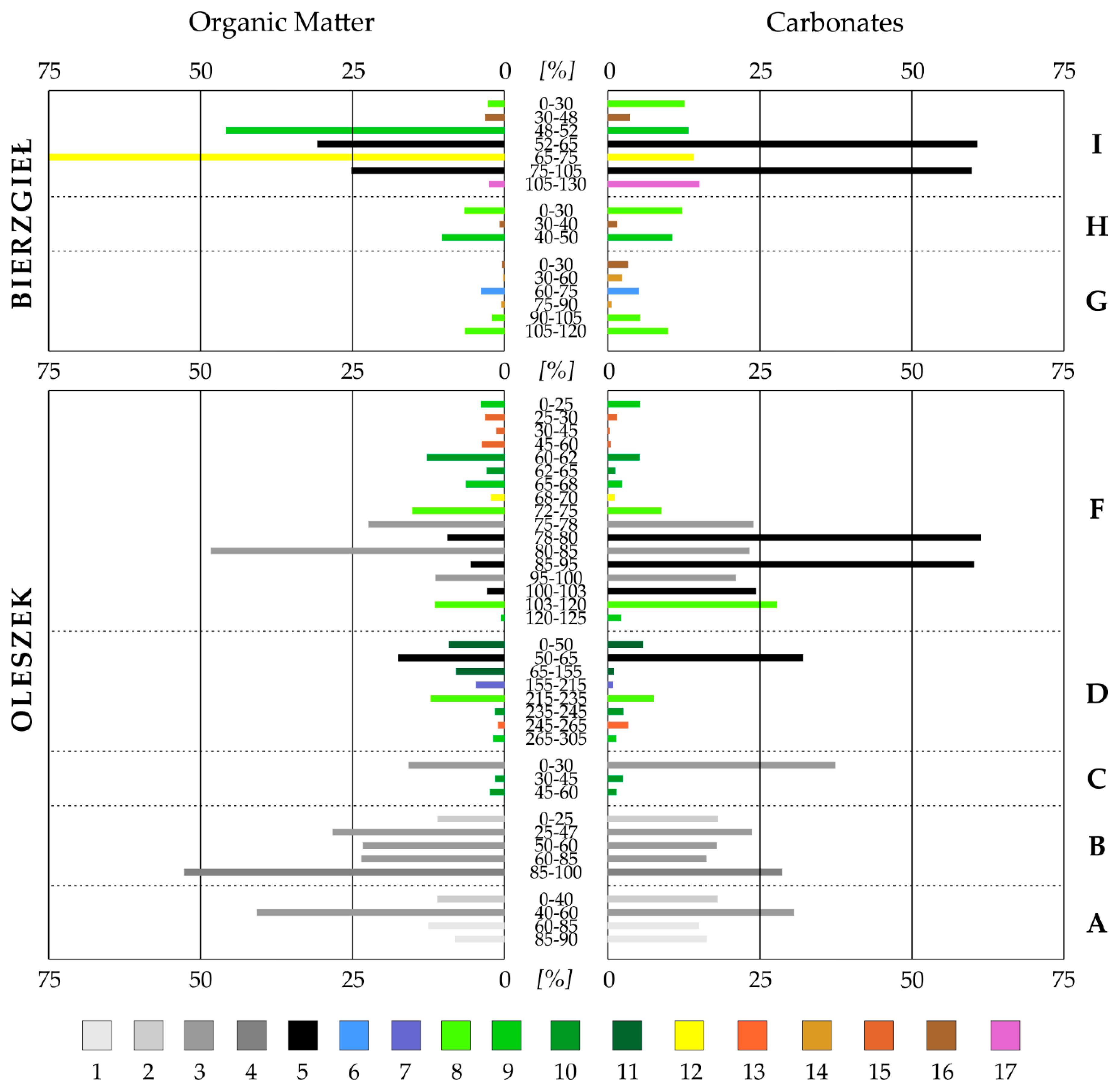
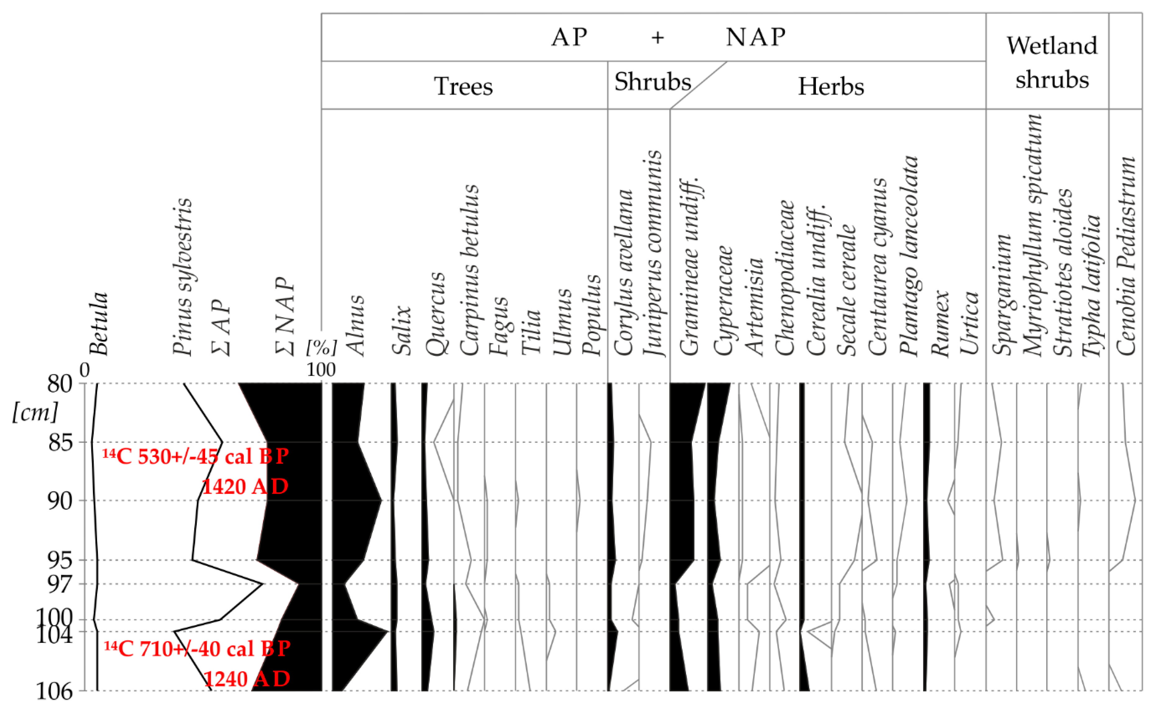
3.2. Characteristics of Sediments in Oleszek and Bierzgieł Ponds
4. Discussion
4.1. Construction and Operation of Water Mills in the Struga Rychnowska Catchment
4.2. Sedimentation in Bierzgieł and Oleszek Ponds
4.3. Water Retention Time
5. Conclusions
- Archival (since 1796) and modern cartographic materials—historical sources containing data on the functioning of water mills—allowed us to determine changes in economic activity in the studied catchment. Thus, it revealed that the patterns in agricultural and forestry land use in the Struga Rychnowska drainage basin were insignificant. Agriculture is still dominating at the moraine plateau, while the forest area has increased in the sandr area. All water mills have been closed down.
- Sediments accumulated in mill ponds (operating in the research area since the 14th century) document changes in the catchment environment during the operation of the mills and after their closing, provided the reservoirs kept the function of water retention. Valuable sources of information about the deposited sediments are their features: granulometric composition, carbonate content, etc.
- Palinological and 14C analyzes are useful in studying the genesis of mill ponds. It was found, among other things, that mill ponds were placed in natural depressions of the land, usually located above steps occurring in narrowings of the subglacial channel, in which the Struga Rychnowska currently flows. In such cases, the formation of ponds was a restitution of a natural water reservoirs (e.g., the Oleszek reservoir). This was confirmed by the age of the youngest sediments determined by the 14C method (530 +/− 45 cal BP–1420 AD), which were deposited in the disappearing water reservoir at the Oleszek site. It follows that these sediments were formed about 300 years earlier before the waters of the Struga Rychnowska were dammed in this place for the needs of the water mill.
- Different water retention times indicate different conditions of pond functioning, despite their locations being in the same catchment area.
- The rate and progress of the process involving basin filling with bottom sediments were affected by: the volume of water mass supplying the ponds and its proportion to total reservoir capacity; morphometric parameters of reservoirs, particularly basin depth and length; location in relation to other elements of hydrographic network directly connected with water mill (e.g., bypass channel); fluctuations of water level in the pond.
Author Contributions
Funding
Acknowledgments
Conflicts of Interest
References and Notes
- Brykała, D. Uwarunkowania przyrodnicze lokalizacji młynów wodnych w zlewni skrwy. In Przemiany Środowiska Przyrodniczego Polski i Jego Funkcjonowanie; German, K., Balon, J., Eds.; IGiGP UJ, PAEK: Kraków, Poland, 2001; pp. 164–171. Available online: https://denali.geo.uj.edu.pl/publikacje,000025?&page=zakup&menu=3&nr=000025_009&brf=summary//full_text.pdf (accessed on 28 November 2019).
- Podgórski, Z. Wpływ Budowy i Funkcjonowania Młynów Wodnych na Rzeźbę Terenu i Wody Powierzchniowe Pojezierza Chełmińskiego i Przyległych Części Dolin Wisły i Drwęcy; UMK Toruń: Toruń, Poland, 2004. [Google Scholar]
- Kaniecki, A.; Brychcy, D. Średniowieczne Młyny Wodne i Ich Wpływ na Przemiany Ich Zasięgu na Produkcji Zlewni Obry Skwierzyńskiej, Bad; Fizjogr, R.I., Seria, A., Eds.; Geografia Fizyczna: Poznań, Poland, 2010; Volume A61, pp. 145–156. [Google Scholar] [CrossRef]
- Fajer, M. Changes in river channel pattern as a result of the construction, operation and decommissioning of watermills—The case of the middle reach of the Liswarta River near Krepice. Environ. Socio-Econ. Stud. 2018, 6, 25–37. [Google Scholar] [CrossRef]
- Fajer, M.; Rzętała, M.A. Mlll pond sediments as the indicator of the environment of the drainage area (an example of Liswarta River, Odra basin, Poland). Environ. Sci. Pollut. Res. 2018, 25, 5832–5847. [Google Scholar] [CrossRef] [PubMed]
- Walter, R.C.; Merritts, D.J. Natural streams and the legacy of waterpowered mills. Science 2008, 319, 299–304. [Google Scholar] [CrossRef] [PubMed]
- Schenk, E.R.; Hupp, C.R. Legacy effects of colonial millponds on floodplain sedimentation, bank erosion, and channel morphology, Mid-Atlantic, USA. J. Am. Water Resour. Assoc. 2009, 45, 597–606. [Google Scholar] [CrossRef]
- Merritts, D.; Walter, R.; Rahnis, M.; Hartranft, J.; Cox, S.; Gellis, A.; Potter, N.; Hilgartner, W.; Langland, M.; Manion, L.; et al. Anthropocene streams and base-level controls from historic dams in the unglaciated mid-Atlantic region, USA. Phil. Trans. R. Soc. A 2011, 369, 976–1009. [Google Scholar] [CrossRef]
- Niemitz, J.; Haynes, C.; Lasher, G. Legacy sediments and historic land use: Chemostratigraphic evidence for excess nutrient and heavy metal sources and remobilization. Geology 2012, 41, 47–50. [Google Scholar] [CrossRef]
- James, L.A. Legacy sediment: Definitions and processes of episodically produced anthropogenic sediment. Anthropocene 2013, 2, 16–26. [Google Scholar] [CrossRef]
- Wegmann, K.W.; Lewis, R.Q.; Hunt, M.C. Historic mill ponds and piedmont stream water quality: Making the connection near Raleigh, North Carolina. In From the Blue Ridge to the Coastal Plain: Field Excursions in the Southeastern United States; Eppes, M.C., Bartholomew, M.J., Eds.; Geological Society of America Field Guide: Dayton, OH, USA, 2012; Volume 29, pp. 93–121. Available online: https://www.academia.edu/17815197/ (accessed on 28 November 2019).
- Podgórski, Z.; Zielski, A.; Brykała, D. Vertical-wheeled watermills in Turznice (Poland) in the light of dendrochronological studies. In Book of Abstracts, Proceedings of the XV International Conference of Historical Geographers, Prague, Czechia, 6–10 August 2012; Charles University in Prague, Faculty of Science: Prague, Czech Republic, 2012; pp. 194–195. Available online: https://www.researchgate.net/publication/286620004_FEATURES_OF_THE_PASTORA L_ACTIVITIES_IN_THE_EUROPEAN_ROMANIC_SPACE_AS_REFLECTED_BY_ANTROPONOMY (accessed on 28 November 2019).
- Niewiarowski, W. Rozwój i przeobrażenia głównych komponentów środowiska geograficznego mikroregionu osadniczego w okolicach gronowa, woj. toruńskie, w późnym plejstocenie i w holocenie. In Studia Nad Osadnictwem Średniowiecznym Ziemi Chełmińskiej. Gronowski Mikroregion Osadniczy; Olczak, J., Ed.; UMK: Toruń, Poland, 1990; pp. 7–26. [Google Scholar]
- Fajer, M.; Machowski, R.; Rzętała, M.; Waga, J.M. Relics of frederician colonisation in southern Poland as cultural and natural tourist destinations—The case of the upper Liswarta river catchment. In Proceedings of the 3rd lnternational Multidisciplinary Scientific Conference on Social Sciences and Arts SGEM 2016, Political Sciences, Law, Finance, Economics and Tourism, Albena, Bulgaria, 24–30 August 2016; Book 2. Volume 5, pp. 531–538. Available online: https://www.researchgate.net/publication/308778357// (accessed on 28 November 2019).
- Foster, I.D.L.; Walling, D.E. Using reservoir deposits to reconstruct changing sediment yields and sources in the catchment of the Old Mill Reservoir, South Devon, U.K., over the past 50 years. Hydrol. Sci. J. 1994, 39, 347–368. [Google Scholar] [CrossRef]
- Trimble, S.W. Dating fluvial processes from historical data and artifacts. Catena 1998, 31, 283–304. [Google Scholar] [CrossRef]
- Michalska, G.; Szpikowski, J. Akumulacja osadów w stawie młyńskim na parsęcie (storkowo, górna parsęta). In Funkcjonowanie Geosystemów Zlewni Rzecznych, cz. 2, UAM, Zakład Geoekologii i Monitoringu Środowiska Przyrodniczego; Kostrzewski, A., Ed.; Stacja Geoekologiczna w Storkowie: Poznań, Poland, 1999; pp. 131–136. Available online: https://www.researchgate.net/publication/260174862// (accessed on 28 November 2019).
- Downward, S.; Skinner, K. Working rivers: The geomorphological legacy of English freshwater mills. Area 2005, 37, 138–147. [Google Scholar] [CrossRef]
- Pizzuto, J.; O’Neal, M. Increased mid-twentieth century riverbank erosion rates related to the demise, South River, Virginia. Geology 2009, 37, 19–22. [Google Scholar] [CrossRef]
- Podgórski, Z. Wpływ budowy młynów wodnych na zmiany krajobrazów pojezierza chełmińskiego. In Krajobraz Kulturowy. Idee, Problemy, Wyzwania, Prace Wydz; Myga-Piątek, U., Ed.; Nauk o Ziemi UŚ: Sosnowiec, Poland, 2001; Volume 12, pp. 117–122. Available online: http://wgsr.uw.edu.pl/wgsr/wp-content/uploads/2018/11/PodgorskiPIS41.pdf (accessed on 28 November 2019).
- Podgórski, Z. Młyny Wodne w Krajobrazie Pojezierza Chełmińskiego. Pr. I Studia Geogr. 2009, 41, 151–161. Available online: http://wgsr.uw.edu.pl/wgsr/wp-content/uploads/2018/11/PodgorskiPIS41.pdf (accessed on 28 November 2019).
- Fajer, M. Watermills—A forgotten river valley heritage—Selected examples from the Silesian voivodeship, Poland. Environ. Socio-Econ. Stud. 2014, 2, 1–9. [Google Scholar] [CrossRef][Green Version]
- Brykała, D.; Podgórski, Z.; Sarnowski, Ł.; Lamparski, P.; Kordowski, J. Wykorzystanie energii wiatru i wody w okresie ostatnich 200 lat na obszarze województwa kujawsko-pomorskiego. Pr. Kom. Kraj. Kult. PTG 2015, 29, 9–22. [Google Scholar]
- Klimek, K.; Kocel, K.; Łokas, E.; Wachniew, W. Osady denne stawu w dolinie Rudy, dorzecze górnej Odry; Zastosowanie metod kartograficznych i radioizotopowych w określaniu tempa sedymentacji. In Człowiek w Środowisku Przyrod-Niczym–Zapis Działalności; Waga, J.M., Kocel, K., Eds.; PTG Oddział Katowicki: Sosnowiec, Poland, 2003; pp. 74–78. [Google Scholar]
- Nascimento, M.R.L.; Mozeto, A.A. Reference values for metals and metalloids concentrations in bottom sediments of Tiete River basin, southeast of Brazil. Contam. Sedyment Contam. 2008, 17, 269–278. [Google Scholar] [CrossRef]
- Rendina, A.; Fabrizio de Iorio, A. Heavy metal partitioning in bottom sediments of the Matanza-riachuelo River and main tributary streams. Contam. Sedyment Contam. 2012, 21, 62–81. [Google Scholar] [CrossRef]
- Podgórski, Z. Antropogeniczne Zmiany Rzeźby Terenu Województwa Toruńskiego, Studia Societatis Scientiarum Torunensis, Sectio C; TNT UMK: Toruń, Poland, 1996; Volume X, p. 4. [Google Scholar]
- Podgórski, Z.; Luc, M. Wykorzystanie trójwymiarowej wizualizacji w badaniach wybranych elementów antropogenicznej rzeźby terenu pojezierza chełmińskiego. In Systemy Informacji Geograficznej W Badaniach Środowiska Przyrodniczego, Problemy Ekologii Krajobrazu, T. 4; Kistowski, M., Ed.; Uniwersytet Gdański: Gdańsk, Poland, 1998; pp. 133–138. Available online: http://www.paek.ukw.edu.pl/ wydaw/pek.htm (accessed on 28 November 2019).
- Podgórski, Z. Etapy rozwoju niecki stawu młyńskiego w Oleszku w świetle badań palinologicz-nych. In Konferencja. Roślinność a Procesy Erozji, Transportu i Depozycji, Katedra Paleogeografii i Paleoekologii Czwartorzędu WNoZ UŚ, Komitet Badań Czwartorzędu PAN; Klimek, K., Kocel, K., Eds.; Stowarzyszenie Geomorfologów Polskich: Sosnowiec, Poland, 2002; pp. 123–127. [Google Scholar]
- Podgórski, Z.; Szmańda, J. Antropogeniczne Przekształcenia Wybranych Fragmentów rynny Strugi Kowalewskiej Wskutek Budowy i Funkcjonowania Młynów Wodnych; Geografia 32; Acta Universitatis Nikolai Copernici: Toruń, Poland, 2002; Volume 109, pp. 111–125. [Google Scholar]
- Podgórski, Z.; Szmańda, J. Parametry uziarnienia osadów małych zbiorników zaporowych pojezierza chełmińskiego na tle osadów wybranych środowisk sedymentacyjnych. In Dokumentacja Geograficzna; Nr 31; IGiPZ PAN: Warszawa, Poland, 2004; pp. 101–103. Available online: http://www.rcin.org.pl/Content/6264/WA51_16111_r2004-nr31_Dokomentacja-Geogr.pdf (accessed on 28 November 2019).
- Mendyk, Ł.; Sykuła, M. Spatial Variability of Actual Soil Moisture, pH and Bulk Soil Electrical Conductivity within the Area of the Former Oleszek Mill Pond Basin. Pol. J. Soil Sci. 2014, CLVII/1, 17–25. Available online: https://journals.umcs.pl/pjss/article/view/219/217 (accessed on 28 November 2019). [CrossRef][Green Version]
- Donovan, M.; Miller, A.; Baker, M. Reassessing the role of milldams in Piedmont floodplain development and remobilization. Geomorphology 2016, 268, 133–145. [Google Scholar] [CrossRef]
- Kaiser, K.; Keller, N.; Brande, A.; Dalitz, S.; Hensel, N.; Heußner, K.U.; Kappler, C.; Michas, U.; Müller, J.; Schwalbe, G.; et al. A large-scale medieval dam-lake cascade in central Europe: Water level dynamics of the Havel River, Berlin-Brandenburg region, Germany. Geoarchaeology 2018, 33, 237–259. [Google Scholar] [CrossRef]
- Maaß, A.L.; Schüttrumpf, H. Elevated floodplains and net channel incision as a result of the construction and removal of water mills. Geogr. Ann. Ser. Aphysical Geogr. 2019, 101, 157–176. [Google Scholar] [CrossRef]
- Brykała, D. Rekonstrukcja retencji zbiornikowej zlewni Skrwy Lewej w ciągu ostatnich 200 lat. Przegląd Geogr. 2005, 77, 69–89. [Google Scholar]
- Niewiarowski, W. Mapa Geomorfologiczna Polski 1: 50 000, ark Torun: Warszawa; Institute of Geography and Spatial Organization Polish Academy of Sciences: Warsaw, Poland, 1958. [Google Scholar]
- Niewiarowski, W. Mapa Geomorfologiczna Polski, 1:50 000, ark Toruń: Kowalewo; Institute of Geography and Spatial Organization Polish Academy of Sciences: Warszawa, Poland, 1965. [Google Scholar]
- Topographic map 1:10000, ark.233.233-Rogówko; Państwowe Przedsiębiorstwo Geodezyjno-Kartograficzne (Zjednoczenie Przedsiębiorstw Geodezyjno-Kartograficznych “GEOKART”): Rzeszów, Poland, 1991.
- Map of the Polish Hydrographic Division; Department of Hydrography and Morphology of River Channels Institute of Meteorology and Water Management. Available online: http://mapa.kzgw.gov.pl/ (accessed on 10 December 2016).
- Digital Elevation Model Data; Institute of Geodesy and Cartography. Available online: http://geoportal.gov.pl// (accessed on 31 January 2013).
- Archiwum Państwowe w Toruniu [State Archives in Torun], no. 650, vol. 496: Borówno-plan wsi, 1798, skala 190 Prętów Reńskich–14,2 cm; 651/T. 310: Borówno–Plan wsi, 1824, skala 240 Prętów Reńskich–18 cm; 700/T. 274: Gronowo–Kanał Odwadniający, 1826, skala 190 Prętów Pruskich–14,2 cm; 792/T. 474: Plan Młyna Oleszek, 1802, skala 150 Prętów Reńskich–11,2 cm; Archiwum Państwowe w Toruniu: Toruń, Poland.
- Reichsamt für Landesaufname… und Königl. Preuss. Landesaufname…; die Karte (Maßstab 1:25 000) Blatt: 1438 (2878)-Kielbasin, 1910; 1512-Preuß. Lanke, 1911; 2978-Gramtschen, 1910 (zbiory UMK w Toruniu).
- Topographische Karte (Maßstab 1:25 000); Sect.: 1267-Jablonowo, 1873; 1431-Kielbaszin, 1873; 1511-Gremboczin, 1873 (zbiory Staatsbibliothek zu Berlin).
- Wiebe, X. Nivellement des Entwäasserungsgrabens für die Adlich Gronower Wiesen und des Oleszker Mühlteiches…; Archiwum Państwowe: Toruń, Poland, 1826; nr 700, teka 274. [Google Scholar]
- Zimmermann, J. Bruillon Plan von dem Thorner Eignthums Dorff Boruwno…; Archiwum Państwowe w Toruniu [State Archives in Torun]: Toruń, Poland, 1802; Volume 496, no. 650. [Google Scholar]
- Mrózek, W. Wody płynące. In Województwo Toruńskie. Przyroda-Ludność i Osadnictwo-Gospodarka; Galon, R., Ed.; PWN: Warszawa, Poland; Poznań, Poland; Toruń, Poland,, 1984; pp. 110–139. [Google Scholar]
- Polish Hydrographic Division. Part I: Numerically-Descriptive Statement; Institute of Meteorology and Water Management: Warszawa, Poland, 1983; p. 924. [Google Scholar]
- Dynowska, I. Typy Reżimów Rzecznych w Polsce, Zeszyty Naukowe Uniwersytetu Jagiellońskiego, Prace Geograficzne, z. 28, Kraków, 151 s. 1972. Available online: http://rcin.org.pl/Content/28024/WA51_ 40060_r1972-z6_Dokumentacja-Geogr1.pdf (accessed on 28 November 2019).
- Pekarova, P.; Miklanek, P.; Pekar, J. Long-term trends and runoff fluctuations of European rivers. Climate Variability and change–hydrological Impacts. In Proceedings of the Fifth FRIEND World Conference, Havana, Cuba, 27 November–2 December 2006; IAHS Publication: Montevideo, Uruguay, 2006; Volume 308, pp. 520–525. Available online: https://iahs.info/uploads/dms/13714.94-520-525-97-308-Pekarova.pdf (accessed on 22 December 2019).
- Studium Gospodarki Wodnej i Retencji Woj. Toruńskiego; Office of Water Project and Melioration: Toruń, Poland, 1981. [Google Scholar]
- Preussisches Urkundenbuch, t. 1-4, 1882–1958, Königsberg-Marburg, 2/1, no. 334. Available online: http://opac. regesta- imperii. de/lang_de/anzeige.php?pk=10159 (accessed on 28 November 2019).
- Karte des Deutschen Reiches, die Karte (Maßstab 1:100 000) Großblatt: 57-Thorn, 1924 oder 1930. Available online: https://www.landkartenarchiv.de/deutschland_kartedesdeutschenreiches.php (accessed on 28 November 2019).
- Schroetter, F. 1803, Karte von Ostpreussen nebst Preussisch Lithauen und Westpreussen nebst dem Netzdistrict (1796–1802), atlas, skala 1: Ca.150 000), Berlin, Sect. XXI. Available online: https://rcin.org.pl/dlibra/ publication/12308 (accessed on 28 November 2019).
- Topographic map 1:1000000, ark.36-27-Toruń; Wojskowy Instytut Geograficzny: Toruń, Poland.
- Topographic map 1:50000, ark.35-27-Grudziądz-A, ark. 36-27-Toruń-B; Sztab Generalny Wojska Polskiego: Warszawa, Poland, 1948.
- Porębska, K. Słownik Historyczno-Geograficzny Ziemi Chełmińskiej w Średniowieczu; Wyd. PAN: Wrocław, Poland; Warszawa, Poland; Kraków, Poland; Gdańsk, Poland, 1971; Available online: http://www.slownik.ihpan.edu.pl// (accessed on 28 November 2019).
- Sulimierski, F.; Chlebowski, B.; Walewski, W. Słownik Geograficzny Królestwa Polskiego i Innych Krajów Słowiańskich, t. I-1880, t. III-1882, t. IV-1883, t. VI-1885, t. VII-1886, t. XI-1890, Warszawa. Available online: http://dir.icm.edu.pl/pl/Slownik_geograficzny/Tom_XI// (accessed on 28 November 2019).
- Arnold, S. Słownik Geograficzny Państwa Polskiego i Ziem Historycznie z Polską Związanych, t. 1: Pomorze Polskie. Pomorze Zachodnie. Prusy Wschodnie, Wyd. Pol. Tow. Krajozn, 1936, Warszawa. Available online: https://fbc.pionier.net.pl/details/oai:www.wbc.poznan.pl:30537 (accessed on 28 November 2019).
- PN-ISO 11277:2005, Soil Quality—Determination of the Particle Size Distribution in Mineral Soil Material—Method by Sieving and Sedimentation, KT 192; Polish Committee for Standardization: Warsaw, Poland.
- ISO 13320:2009, Particle Size Analysis—Laser Diffraction Methods, ISO/TC 24/SC 4, Particle Characterization. Available online: https://www.sis.se/api/document/preview/911506/ (accessed on 29 November 2019).
- Instrukcja w sprawie opracowania i wydania Szczegółowej Mapy Geologicznej Polski w skali 1:50 000, wydanej na podstawie zarządzenia Prezesa Centralnego Urzędu Geologicznego z dnia 21 października 1975 r. dla osadów piaszczysto-mułkowo-ilastych (CUGIG 1975), Wyd. Geol., Warszawa.
- Bengtsson, L.; Enell, M. Chemical analysis. In Handbook of Holocene Palaeoecology and Palaeohydrology; Berglund, B.E., Ed.; John Wiley & Sons Ltd.: Chichester, UK, 1986; pp. 423–451. [Google Scholar]
- Januszkiewicz, T. Studia nad metodą analizy chemicznej składu współczesnych osadów dennych jezior. Zesz. Nauk. 1978, 8, 3–29. [Google Scholar]
- Rzepecki, P. Klasyfikacja i główne typy litologiczne osadów jeziornych. Zesz. Nauk. AGH, Geologia 1983, 9, 73–94. [Google Scholar]
- Folk, R.L.; Ward, W.C. Brazos river bar, a study in the significance of grain size parameters. J. Sed. Pertol. 1957, 27, 3–26. [Google Scholar] [CrossRef]
- Passega, R. Grain-size representation by CM patterns as a geological tool. J. Sed. Petrol. 1964, 34, 830–847. Available online: http://citeseerx.ist.psu.edu/viewdoc/download?doi=10.1.1.890.8534&rep=rep1&type=pdf (accessed on 29 November 2019). [CrossRef]
- Passega, R.; Byramjee, R. Grain size image of clastic deposits. Sedimentology 1969, 13, 830–847. [Google Scholar] [CrossRef]
- Kalib14C. Available online: https://www.adamwalanus.pl/c14cal.html (accessed on 2 December 2019).
- Berglund, B.F.; Ralska-Jasiewiczowa, M. Pollen analysis and pollen diagrams. In Handbook of Holocene Palaeoecology and Palaeohydrology; Berglund, B.E., Ed.; John Wi-ley & Sons Ltd.: Chichester, UK, 1986; pp. 455–484. [Google Scholar]
- Erdtman, G. An Introduction to Pollen Analysis; Read Books Ltd.: Waltham, MA, USA, 1953. [Google Scholar]
- Starmach, K. Hydrobiologiczne podstawy użytkowania przez wodociągi płytkich zbiorników rzecznych. Pol. Archiw. Hydrob. 1958, 4, 10–67. [Google Scholar]
- Lech, A. Uboczna produkcja młynarska w XVII-XIX w. In Studia z Dziejów Gospodarstwa Wiejskiego; t. 12, z. 1; IHKM PAN, PWN: Warszawa, Poland, 1970; pp. 181–202. [Google Scholar]
- Małyszycki, S. Młynarstwo Zbożowe, t. 1, Warszawa, 359 s. 1890. Available online: https://rcin.org.pl/dlibra/show-content/publication/edition/5670?id=5670 (accessed on 8 December 2019).
- Zając, K. Polska Czerwona Księga Zwierząt: Anodonta cygnea (Linnaeus, 1758). Instytut Ochrony Przyrody PAN. 2011. Available online: http://www.iop.krakow.pl/pckz/opis8ec2.html?id=128&je=pl (accessed on 8 December 2019).
- Celmer, T.; Marciniak, K.; Wójcik, G. Wody powierzchniowe i podziemne. In Zintegrowany Monitoring Środowiska Przyrodniczego–Stacja Bazowa w Koniczynce; Wójcik, G., Marciniak, I.K., Eds.; Biblioteka Monitoringu Środowiska: Warszawa, Poland; Toruń, Poland, 1996; pp. 77–89. [Google Scholar]
- Sundborg, A. The River Klarälven, a study of fluvial processes. Geogr. Ann. 1956, 38, 127–316. [Google Scholar] [CrossRef]
- Sundborg, A. Some aspects on fluvial sediments and fluvial morphology. Geogr. Ann. 1967–1968, 49–50. [Google Scholar] [CrossRef]
- Łajczak, A. Studium Nad Zamulaniem Wybranych Zbiorników Zaporowych w Dorzeczy Wisły; Monografie Komitetu Gospodarki Wodnej PAN nr 8; Oficyna Wydawnicza Politechniki Warszawskiej: Warszawa, Poland, 1995; p. 108. [Google Scholar]
- Cyberski, J. Zjawiska akumulacyjno-erozyjne w rzekach objętych działaniem budowli piętrzących. Czas. Geogr. 1984, 55, 355–363. [Google Scholar]
- Jespersen, A. Trough or pentrough Regional Preference or Historical Development. In Proceedings of the Transactions of the Fifth Symposium The International Molinological Society (TIMS), Paris, France, 5–10 April 1982; pp. 229–247. [Google Scholar]
- Gołdyn, R. Zmiany Biologicznych i Fizyczno-Chemicznych Cech Jakości Wody Rzecznej Pod Wpływem Jej Piętrzenia We Wstępnych, Nizinnych Zbiornikach Zaporowych; Wydawnictwo Naukowe UAM: Poznań, Poland, 2000; p. 185. [Google Scholar]


| Name of Watermill | Surface Area [in ha] | Length (L) [in m] | Width (W) | Depth [m] | Capacity [thous. m3] | Coefficient of Pond Extension (λ = L/Wav.) | Development of Shoreline (K*) | |
|---|---|---|---|---|---|---|---|---|
| Max [in m] | Av. [in m] | |||||||
| Krupka | 0.18 | 46 | 49 | 40.2 | 1.5 | 14.7 | 1.1 | 1.07 |
| Struś | 0.30 | 101 | 43 | 29.9 | 1.0–1.4 | 5.1 | 3.4 | 1.20 |
| Papiernia | 0.52 | 224 | 35 | 23.2 | 0.8–1.3 | 4.3 | 9.6 | 1.81 |
| Bierzgieł | 0.65 | 186 | 45 | 34.9 | 1.3 | 46.2 | 5.3 | 1.36 |
| Pachura | 0.67 | 215 | 49 | 31.4 | 1.4 | 12.6 | 6.8 | 1.68 |
| Skrobacz | 1.20 | 221 | 87 | 54.1 | 1.3–1.5 | 10.0 | 4.1 | 1.34 |
| Juda | 1.30 | 349 | 41 | 37.1 | 1.4 | 7.6 | 9.4 | 1.75 |
| Oleszek | 2.37 | 458 | 86 | 51.7 | 1.4 | 22.4 | 8.9 | 1.71 |
| Profile Name | Watercourse Length (in m) | Catchment Surface Area (in km2) | Altitude (m above Sea Level) | Watercourse Valley Bottom Fall (in ‰) | |||||
|---|---|---|---|---|---|---|---|---|---|
| between Profiles | Increment | Sum | above mill | below mill | between Profiles | Av. | between Profiles | Av. | |
| Mlewieckie L. | 0 | 0 | 0 | 86.5 | 0 | 0 | 0 | 0 | |
| Oleszek | 6580 | 15.06 | 15.06 | 79.5 | 77.6 | 1.06 | 1.06 | 1.35 | 1.35 |
| Juda | 1355 | 19.80 | 34.86 | 76.2 | 72.5 | 2.44 | 1.30 | 3.76 | 1.76 |
| Krupka | 695 | 3.06 | 37.92 | 71.8 | 69.8 | 6.33 | 1.71 | 3.88 | 1.94 |
| Skrobacz | 765 | 0.67 | 38.59 | 67.3 | 64.5 | 5.88 | 2.05 | 6.93 | 2.34 |
| Struś | 230 | 0.32 | 38.91 | 64.6 | 63.0 | 11.74 | 2.28 | 2.52 | 2.44 |
| Papiernia | 670 | 0.43 | 39.34 | 62.5 | 60.4 | 3.13 | 2.33 | 3.88 | 2.54 |
| Bierzgieł | 3525 | 7.81 | 47.15 | 52.5 | 49.6 | 2.84 | 2.46 | 3.06 | 2.67 |
| Pachura | 835 | 1.44 | 48.59 | 47.0 | 45.5 | 6.59 | 2.70 | 4.91 | 2.80 |
| Drwęca R. | 675 | 0.68 | 49.27 | 43.5 | 5.26 | 2.83 | 3.03 | 2.83 | |
| Name of Watermill | Year | Surface Area (in ha) | Length (L) (in m) | Width (W) | Coefficient of Pond Extension (λ) | Development of Shoreline (K) | |
|---|---|---|---|---|---|---|---|
| Max (in m) | Av. (in m) | ||||||
| Bierzgieł | 1873 | 0.65 | 186 | 45 | 34.9 | 5.3 | 1.36 |
| 1910 | 3.56 | 369 | 223 | 96.4 | 3.8 | 1.28 | |
| 1992 | 1.03 | 107 | 103 | 96.0 | 1.1 | 1.04 | |
| Oleszek | 1798 | 4.29 | 819 | 101 | 52.3 | 15.6 | 1.97 |
| 1802 | 4.38 | 809 | 109 | 54.2 | 14.9 | 1.85 | |
| 1873 | 2.37 | 458 | 86 | 51.7 | 8.9 | 1.71 | |
| 1924 | 2.60 | 615 | 74 | 42.2 | 14.6 | 2.28 | |
© 2020 by the authors. Licensee MDPI, Basel, Switzerland. This article is an open access article distributed under the terms and conditions of the Creative Commons Attribution (CC BY) license (http://creativecommons.org/licenses/by/4.0/).
Share and Cite
Podgórski, Z.; Szatten, D. Changes in the Dynamics and Nature of Sedimentation in Mill Ponds as an Indicator of Environmental Changes in a Selected Lake Catchment (Chełmińskie Lake District, Poland). Water 2020, 12, 268. https://doi.org/10.3390/w12010268
Podgórski Z, Szatten D. Changes in the Dynamics and Nature of Sedimentation in Mill Ponds as an Indicator of Environmental Changes in a Selected Lake Catchment (Chełmińskie Lake District, Poland). Water. 2020; 12(1):268. https://doi.org/10.3390/w12010268
Chicago/Turabian StylePodgórski, Zbigniew, and Dawid Szatten. 2020. "Changes in the Dynamics and Nature of Sedimentation in Mill Ponds as an Indicator of Environmental Changes in a Selected Lake Catchment (Chełmińskie Lake District, Poland)" Water 12, no. 1: 268. https://doi.org/10.3390/w12010268
APA StylePodgórski, Z., & Szatten, D. (2020). Changes in the Dynamics and Nature of Sedimentation in Mill Ponds as an Indicator of Environmental Changes in a Selected Lake Catchment (Chełmińskie Lake District, Poland). Water, 12(1), 268. https://doi.org/10.3390/w12010268