Operational Flood Detection Using Sentinel-1 SAR Data over Large Areas


Abstract
1. Introduction
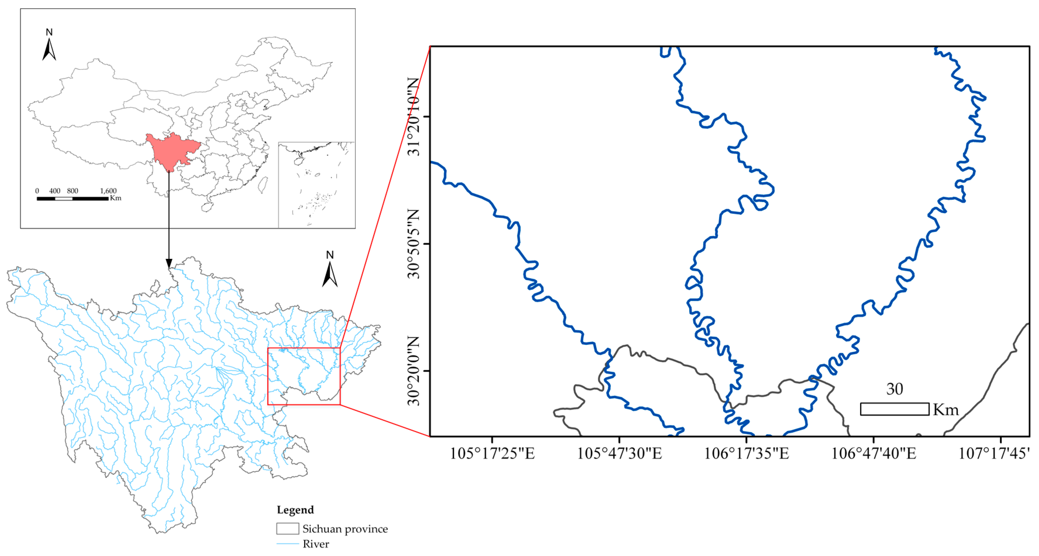
2. Study Area and Data Description
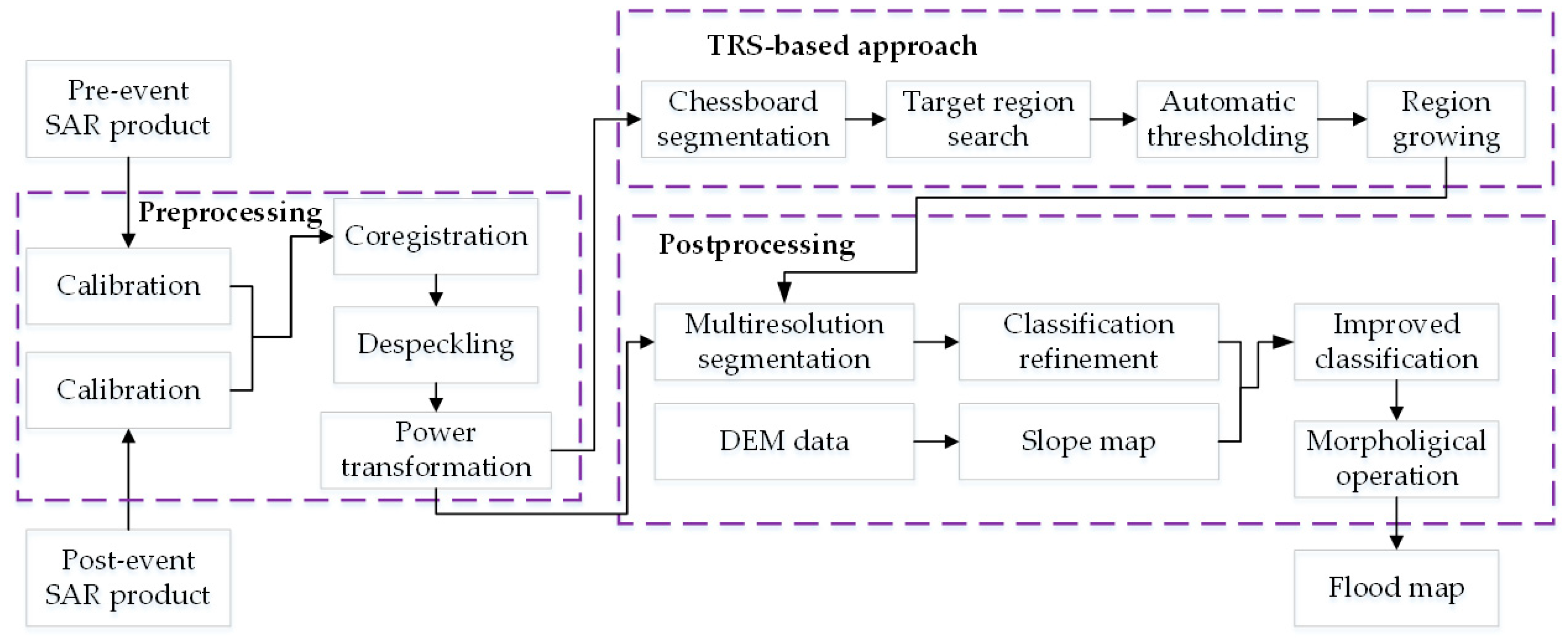
3. Methodology
3.1. Preprocessing
3.2. Bimodality Test and Transformation of Normality
3.3. Target Region Search (TRS) Approach
- (Step 1)
- Apply a chessboard segmentation algorithm to the power-transformed image with size , that is, dividing the image into regions of size . The regions in the last row and column are ignored if their sizes are less than . The total number of regions is denoted by . Let the current region be the first region, that is, .
- (Step 2)
- Compute the value of the current region if . If , the current region is regarded as a target region; record the location of the current region and the region size. If , go to Step 4.
- (Step 3)
- Let and return to Step 2.
- (Step 4)
- If at least one target region is searched, stop the process. Otherwise, change the starting point of the segmentation to , and repeat Steps 1 through 3. If no target region is found after changing the starting point of the segmentation once, change the starting point again to and repeat Steps 1 through 3. If still no target region is found after changing the starting point twice, go to Step 5.
- (Step 5)
- Let , that is, change the segmentation scale. If , repeat Steps 1 through 4. If , stop the process.
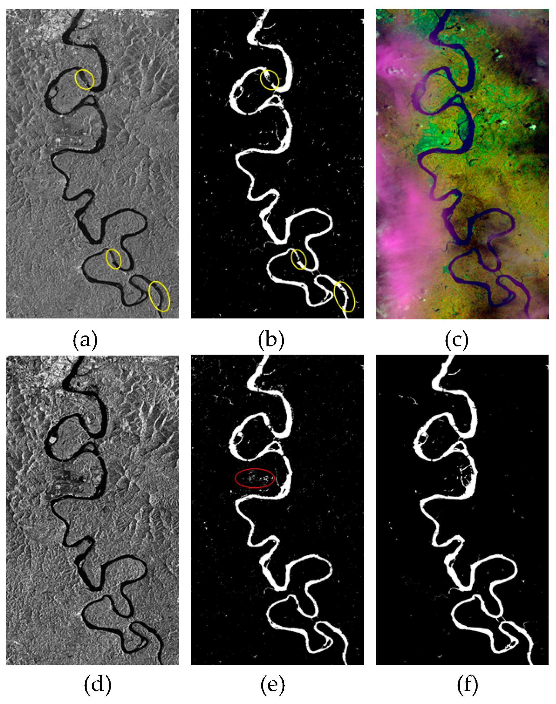
3.4. Thresholding and Region-Growing-Based Water Extraction
- (Step 1)
- Compute the histogram of the selected region, where is the intensity level of the target region. Let be the histogram after the kth iteration of the Gaussian convolution. is set to 0 at this stage.
- (Step 2)
- Apply the 1D Gaussian convolution with kernel size 3 to to derive , where is the histogram after the (k−1)th iteration of the Gaussian convolution applying to .
- (Step 3)
- Detect the number of peaks of . If has more than two peaks, let and return to Step 2. If has two peaks located at and , then detect the valley between and .
3.5. Postprocessing
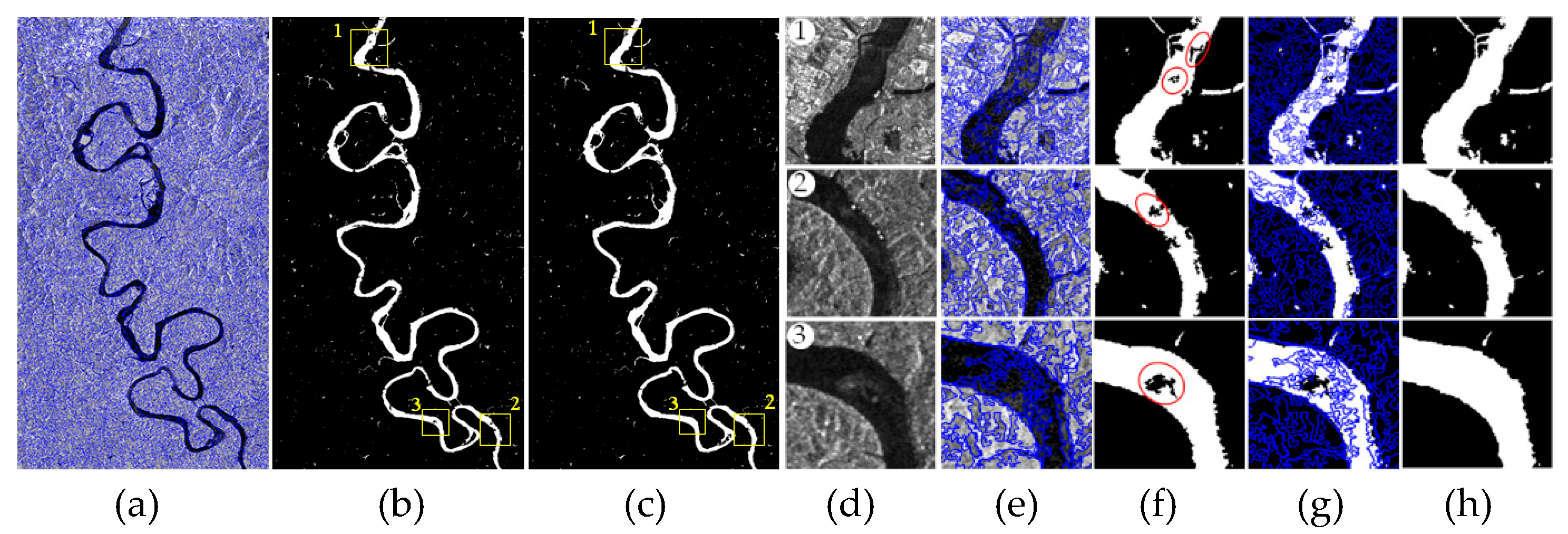
4. Experiment Results
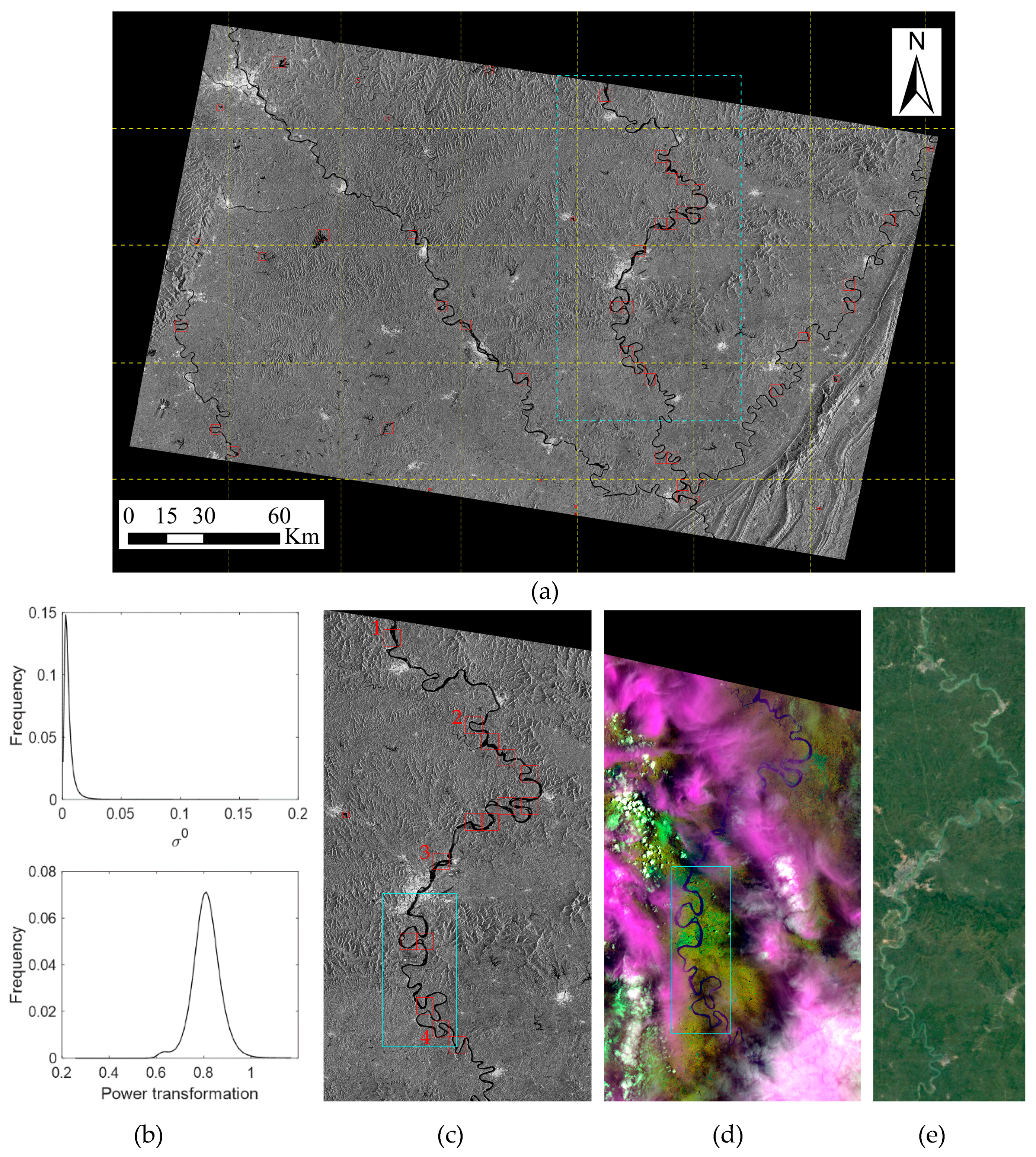
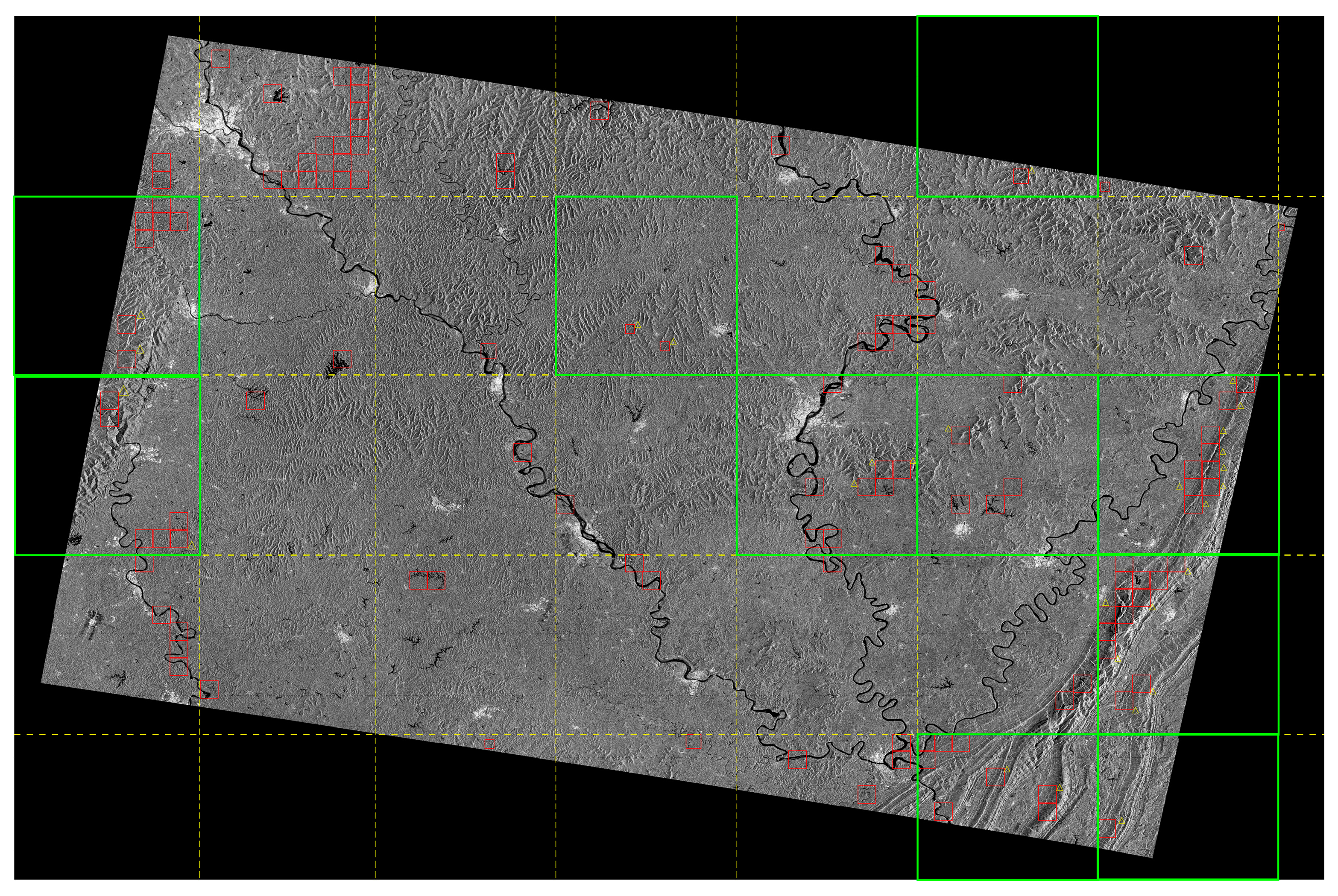
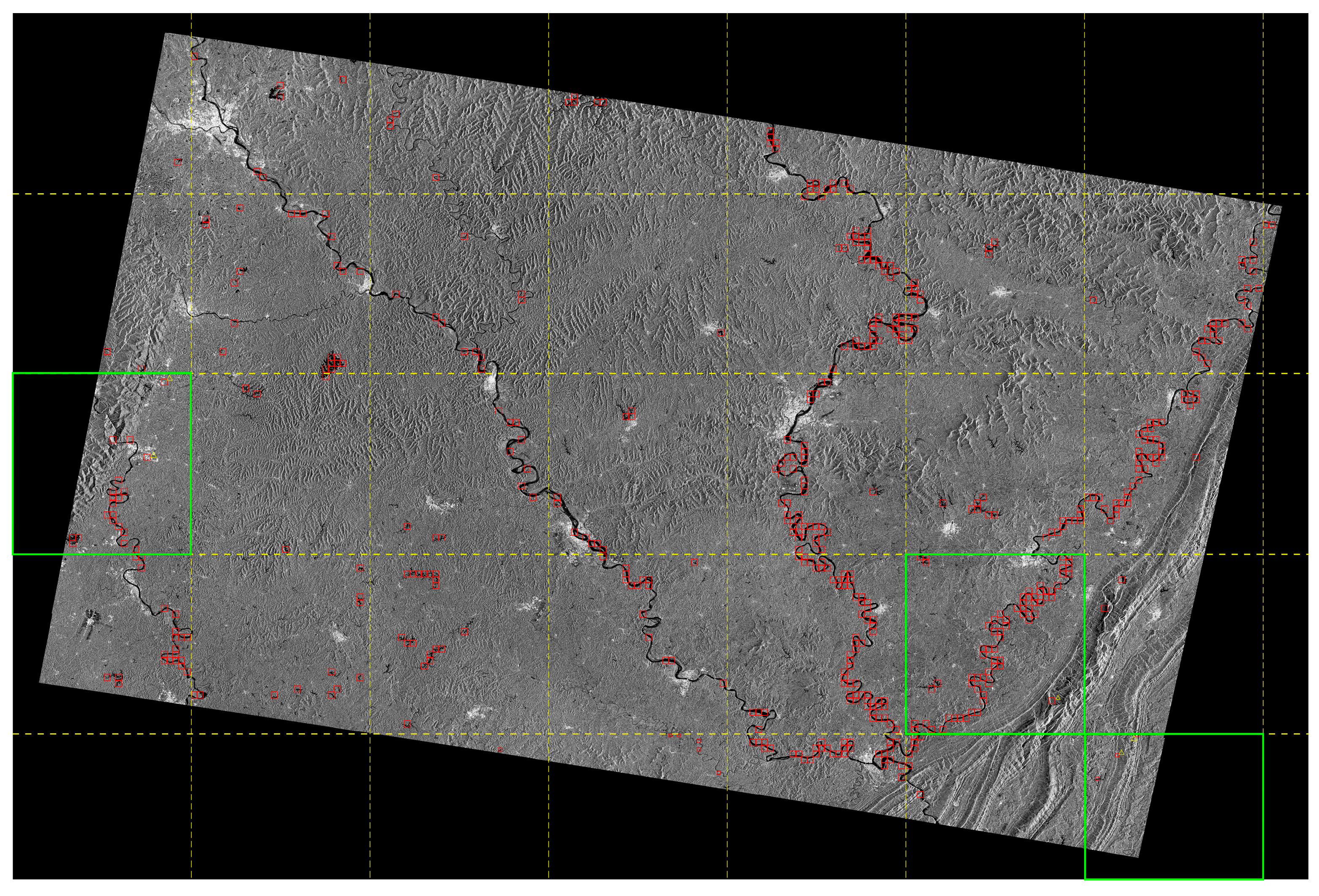
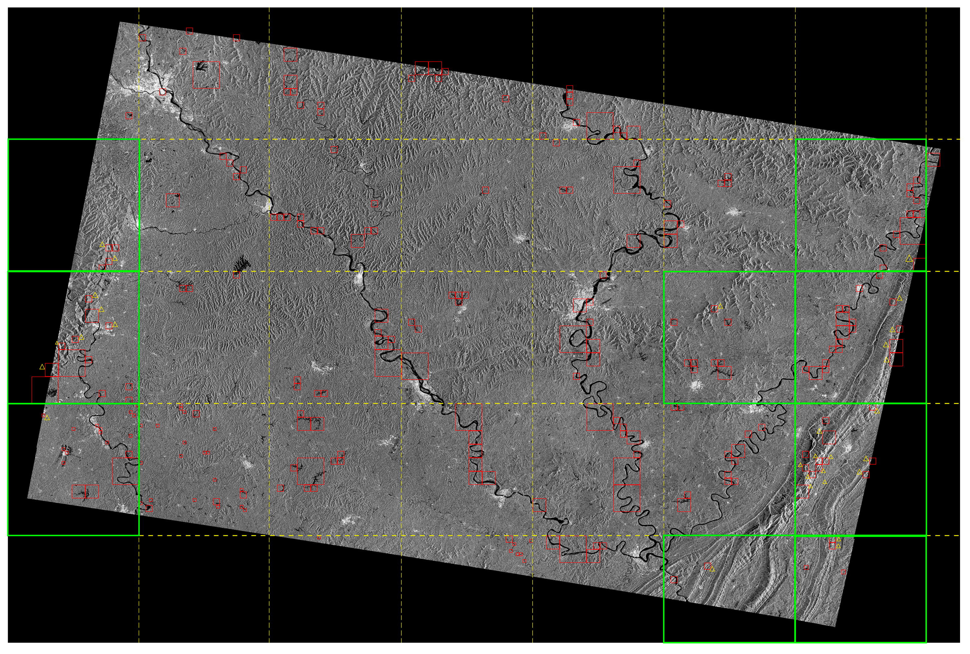
4.1. Application of TRS Approach
4.2. Flood Detection Comparison by Various Methods in Dual Polarization
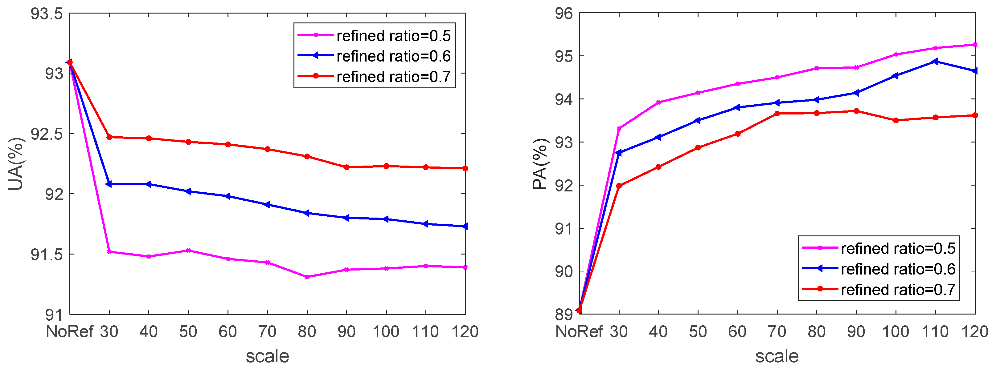
4.3. Multiresolution Segmentation-Based Refinement
4.4. Flood Dynamics
5. Discussion
6. Conclusions
Author Contributions
Funding
Acknowledgments
Conflicts of Interest
References
- Blasco, F.; Bellan, M.F.; Chaudhury, M.U. Estimating the extent of floods in Bangladesh using SPOT Data. Remote Sens. Environ. 1992, 39, 167–178. [Google Scholar] [CrossRef]
- Tholey, N.; Clandillon, S.; De Fraipont, P. The contribution of spaceborne SAR and optical data in monitoring flood events: Examples in northern and southern France. Hydrol. Process. 2015, 11, 1409–1413. [Google Scholar] [CrossRef]
- Hoque, R.; Nakayama, D.; Matsuyama, H.; Matsumoto, J. Flood monitoring, mapping and assessing capabilities using RADARSAT remote sensing, GIS and ground data for Bangladesh. Nat. Hazards 2011, 57, 525–548. [Google Scholar] [CrossRef]
- Henry, J.B.; Chastanet, P.; Fellah, K.; Desnos, Y.L. Envisat multi-polarized ASAR data for flood mapping. Int. J. Remote Sens. 2006, 27, 1921–1929. [Google Scholar] [CrossRef]
- Kuenzer, C.; Guo, H.; Huth, J.; Leinenkugel, P.; Li, X.; Dech, S. Flood Mapping and Flood Dynamics of the Mekong Delta: ENVISAT-ASAR-WSM Based Time Series Analyses. Remote Sens. 2013, 5, 687–715. [Google Scholar] [CrossRef]
- Iervolino, P.; Guida, R.; Iodice, A.; Riccio, D. Flooding Water Depth Estimation With High-Resolution SAR. IEEE Trans. Geosci. Remote Sens. 2015, 53, 2295–2307. [Google Scholar] [CrossRef]
- Richards, J.A.; Woodgate, P.W.; Skidmore, A.K. An explanation of enhanced radar backscattering from flooded forests. Int. J. Remote Sens. 1987, 8, 1093–1100. [Google Scholar] [CrossRef]
- Hess, L.L.; Melack, J.M.; Simonett, D.S.; Sieber, A.J. Radar detection of flooding beneath the forest canopy: A review. Int. J. Remote Sens. 1990, 11, 1313–1325. [Google Scholar] [CrossRef]
- Townsend, P. Relationships between forest structure and the detection of flood inundation in forested wetlands using C-band SAR. Int. J. Remote Sens. 2002, 23, 443–460. [Google Scholar] [CrossRef]
- Kasischke, E.S.; Bourgeau-Chavez, L.L. Monitoring South Florida wetlands using ERS-1 SAR imagery. Photogramm. Eng. Remote Sens. 1997, 63, 281–291. [Google Scholar]
- Oberstadler, R.; Hönsch, H.; Huth, D. Assessment of the mapping capabilities of ERS-1 SAR data for flood mapping: A case study in Germany. Hydrol. Process. 1997, 11, 1415–1425. [Google Scholar] [CrossRef]
- Townsend, P.A. Estimating forest structure in wetlands using multitemporal SAR. Remote Sens. Environ. 2002, 79, 288–304. [Google Scholar] [CrossRef]
- De Roo, A.; Van Der Knijff, J.; Horritt, M.; Schmuck, G.; De Jong, S. Assessing flood damages of the 1997 Oder flood and the 1995 Meuse flood. In Proceedings of the Second International ITC Symposium on Operationalization of Remote Sensing, Enschede, The Netherlands, 16–20 August 1999. [Google Scholar]
- Schumann, G.; Henry, J.; Hoffmann, L.; Pfister, L.; Pappenberger, F.; Matgen, P. Demonstrating the high potential of remote sensing in hydraulic modelling and flood risk management. In Proceedings of the Annual Conference of the Remote Sensing and Photogrammetry Society with the NERC Earth Observation Conference, Portsmouth, UK, 6–9 September 2005. [Google Scholar]
- Schumann, G.; Baldassarre, G.D.; Alsdorf, D.; Bates, P.D. Near real-time flood wave approximation on large rivers from space: Application to the River Po, Italy. Water Resour. Res. 2010, 46, 1–8. [Google Scholar] [CrossRef]
- Delmeire, S. Use of ERS-1 data for the extraction of flooded areas. Hydrol. Process. 1997, 11, 1393–1396. [Google Scholar] [CrossRef]
- Bazi, Y.; Bruzzone, L.; Melgani, F. An unsupervised approach based on the generalized Gaussian model to automatic change detection in multitemporal SAR images. IEEE Trans. Geosci. Remote Sens. 2005, 43, 874–887. [Google Scholar] [CrossRef]
- Matgen, P.; Schumann, G.; Henry, J.B.; Hoffmann, L.; Pfister, L. Integration of SAR-derived river inundation areas, high-precision topographic data and a river flow model toward near real-time flood management. Int. J. Appl. Earth Obs. Geoinf. 2007, 9, 247–263. [Google Scholar] [CrossRef]
- Bates, P.; Horritt, M.; Smith, C.; Mason, D. Integrating remote sensing observations of flood hydrology and hydraulic modelling. Hydrol. Process. 1997, 11, 1777–1795. [Google Scholar] [CrossRef]
- Westerhoff, R.S.; Kleuskens, M.P.H.; Winsemius, H.C.; Huizinga, H.J. Automated global water mapping based on wide-swath orbital synthetic aperture radar. Hydrol. Earth Syst. Sci. 2013, 17, 651–663. [Google Scholar] [CrossRef]
- Pulvirenti, L.; Marzano, F.S.; Pierdicca, N.; Mori, S.; Chini, M. Discrimination of water surfaces, heavy rainfall, and wet snow using COSMO-SkyMed observations of severe weather events. IEEE Trans. Geosci. Remote Sens. 2014, 52, 858–869. [Google Scholar] [CrossRef]
- Lee, S.U.; Chung, S.Y.; Park, R.H. A comparative performance study of several global thresholding techniques for segmentation. Comput. Vis. Graph. Image Process. 1990, 52, 171–190. [Google Scholar] [CrossRef]
- Martinis, S.; Twele, A.; Voigt, S. Towards operational near real-time flood detection using a split-based automatic thresholding procedure on high resolution TerraSAR-X data. Nat. Hazards Earth Syst. Sci. 2009, 9, 303–314. [Google Scholar] [CrossRef]
- Martinis, S.; Kersten, J.; Twele, A. A fully automated TerraSAR-X based flood service. ISPRS J. Photogramm. Rem. Sens. 2015, 104, 203–212. [Google Scholar] [CrossRef]
- Twele, A.; Cao, W.; Plank, S.; Martinis, S. Sentinel-1-based flood mapping: A fully automated processing chain. Int. J. Remote Sens. 2016, 37, 2990–3004. [Google Scholar] [CrossRef]
- Schumann, G.J.-P.; Neal, J.C.; Mason, D.C.; Bates, P.D. The accuracy of sequential aerial photography and SAR data for observing urban flood dynamics, a case study of the UK summer 2007 floods. Remote Sens. Environ. 2011, 115, 2536–2546. [Google Scholar] [CrossRef]
- Matgen, P.; Hostache, R.; Schumann, G.; Pfister, L.; Hoffmann, L.; Savenije, H.H.G. Towards an automated SAR-based flood monitoring system: Lessons learned from two case studies. Phys. Chem. Earth Parts A/B/C 2011, 36, 241–252. [Google Scholar] [CrossRef]
- Chini, M.; Hostache, R.; Giustarini, L.; Matgen, P. A Hierarchical Split-Based Approach for Parametric Thresholding of SAR Images: Flood Inundation as a Test Case. IEEE Trans. Geosci. Remote Sens. 2017, 55, 6975–6988. [Google Scholar] [CrossRef]
- Demirkaya, O.; Asyali, M.H. Determination of image bimodality thresholds for different intensity distributions. Signal Process. Image Commun. 2004, 19, 507–516. [Google Scholar] [CrossRef]
- Hu, H.; Ban, Y. Unsupervised change detection in multitemporal SAR images over large urban areas. IEEE J. Sel. Top. Appl. Earth Obs. Remote Sens. 2014, 7, 3248–3261. [Google Scholar] [CrossRef]
- Ulaby, F.T.; Dobson, M.C. Handbook of Radar Scattering Statistics for Terrain (Artech House Remote Sensing Library); Artech House: Norwood, MA, USA, 1989. [Google Scholar]
- Kukunage, K. Introduction to Statistical Pattern Recognition; Academic Press: Boston, MA, USA, 1990. [Google Scholar]
- Xin, N.; Zhang, J.; Wang, G.; Liu, Q. Research on normality of power transform in radar target recognition. Mod. Radar 2007, 29, 48–51. [Google Scholar]
- Tsai, D.M. A fast thresholding selection procedure for multimodal and unimodal histograms. Pattern Recognit. Lett. 1995, 16, 653–666. [Google Scholar] [CrossRef]
- Rattarangsi, A.; Chin, R.T. Scale-based detection of corners of planar curves. In Proceedings of the 10th International Conference on Pattern Recognition, Atlantic City, NJ, USA, 16–21 June 1990. [Google Scholar]
- Kittler, J.; Illingworth, J. Minimum error thresholding. Pattern Recognit. 1986, 19, 41–47. [Google Scholar] [CrossRef]
- Blaschke, T. Object based image analysis for remote sensing. Isprs J. Photogramm. Rem. Sens. 2010, 65, 2–16. [Google Scholar] [CrossRef]
- Pradhan, B.; Sameen, M.I.; Kalantar, B. Optimized rule-based flood mapping technique using multitemporal RADARSAT-2 images in the tropical region. IEEE J. Sel. Top. Appl. Earth Obs. Remote Sens. 2017, 10, 3190–3199. [Google Scholar] [CrossRef]
- Boni, G.; Ferraris, L.; Pulvirenti, L.; Squicciarino, G.; Pierdicca, N.; Candela, L.; Pisani, A.R.; Zoffoli, S.; Onori, R.; Proietti, C. A Prototype System for Flood Monitoring Based on Flood Forecast Combined with COSMO-SkyMed and Sentinel-1 Data. IEEE J. Sel. Top. Appl. Earth Obs. Remote Sens. 2017, 9, 2794–2805. [Google Scholar] [CrossRef]
- Xu, H. Modification of normalised difference water index (NDWI) to enhance open water features in remotely sensed imagery. Int. J. Remote Sens. 2006, 27, 3025–3033. [Google Scholar] [CrossRef]
- Manjusree, P.; Kumar, L.P.; Bhatt, C.M.; Rao, G.S.; Bhanumurthy, V. Optimization of threshold ranges for rapid flood inundation mapping by evaluating backscatter profiles of high incidence angle SAR images. Int. J. Disaster Risk Sci. 2012, 3, 113–122. [Google Scholar] [CrossRef]
- Clement, M.A.; Kilsby, C.G.; Moore, P. Multi-temporal synthetic aperture radar flood mapping using change detection. J. Flood Risk Manag. 2017, 11, 152–168. [Google Scholar] [CrossRef]


| Sentinel-1 SAR data | |||||
|---|---|---|---|---|---|
| Acquisition Date | Mode | Orbit | Incidence angle | Pixel spacing | Polarization |
| 2018-05-04 (pre-flood) | IW | Descending | 30.73°–46.05° | 10 m × 10 m | VV-VH |
| 2018-07-03 (flooding) | IW | Descending | 30.73°–46.05° | 10 m × 10 m | VV-VH |
| 2018-07-15 (flooding) | IW | Descending | 30.73°–46.05° | 10 m × 10 m | VV-VH |
| Landsat-8 Operational Land Imager (OLI) data | |||||
| Acquisition Date | Path | Row | Pixel spacing | Cloud cover (%) | |
| 2018-07-16 (flooding) | 128 | 39 | 30 m | 76.56 | |
| Number | Water Mode | LM Threshold | KI Threshold |
|---|---|---|---|
| 1 | 0.6160 | 0.6914 | 0.6708 |
| 2 | 0.6257 | 0.6939 | 0.6734 |
| 3 | 0.6203 | 0.6909 | 0.6698 |
| 4 | 0.6314 | 0.7086 | 0.6893 |
| Range | 0.0154 | 0.0177 | 0.0195 |
| Method | No. | False No. | Time (min.) |
|---|---|---|---|
| and | 120 | 27 | 8 |
| BC | 546 | 5 | 20 |
| Chini’s method | 251 | 27 | 11 |
| 52 | 0 | 15 |
| Method | Kappa Coefficient | OA(%) | UA(%) | PA(%) |
|---|---|---|---|---|
| OTSU | 0.34 | 81.49 | 26.33 | 97.08 |
| TRS_OTSU | 0.72 | 95.54 | 60.89 | 94.74 |
| TRS_KI_THR | 0.88 | 98.60 | 95.34 | 85.29 |
| TRS_LM_THR | 0.87 | 98.42 | 87.41 | 89.39 |
| TRS_KI_RGA | 0.89 | 98.71 | 95.26 | 85.04 |
| TRS_LM_RGA | 0.91 | 98.82 | 93.09 | 89.09 |
| Method | Kappa Coefficient | OA(%) | UA(%) | PA(%) |
|---|---|---|---|---|
| OTSU | 0.31 | 78.93 | 23.98 | 97.86 |
| TRS_OTSU | 0.63 | 93.53 | 51.07 | 96.25 |
| TRS_KI_THR | 0.89 | 98.59 | 91.08 | 87.72 |
| TRS_LM_THR | 0.82 | 97.95 | 75.57 | 93.17 |
| TRS_KI_RGA | 0.88 | 98.59 | 91.12 | 87.64 |
| TRS_LM_RGA | 0.86 | 98.22 | 82.74 | 92.95 |
© 2019 by the authors. Licensee MDPI, Basel, Switzerland. This article is an open access article distributed under the terms and conditions of the Creative Commons Attribution (CC BY) license (http://creativecommons.org/licenses/by/4.0/).
Share and Cite
Cao, H.; Zhang, H.; Wang, C.; Zhang, B. Operational Flood Detection Using Sentinel-1 SAR Data over Large Areas. Water 2019, 11, 786. https://doi.org/10.3390/w11040786
Cao H, Zhang H, Wang C, Zhang B. Operational Flood Detection Using Sentinel-1 SAR Data over Large Areas. Water. 2019; 11(4):786. https://doi.org/10.3390/w11040786
Chicago/Turabian StyleCao, Han, Hong Zhang, Chao Wang, and Bo Zhang. 2019. "Operational Flood Detection Using Sentinel-1 SAR Data over Large Areas" Water 11, no. 4: 786. https://doi.org/10.3390/w11040786
APA StyleCao, H., Zhang, H., Wang, C., & Zhang, B. (2019). Operational Flood Detection Using Sentinel-1 SAR Data over Large Areas. Water, 11(4), 786. https://doi.org/10.3390/w11040786