Article

Describing and Visualizing a Water–Energy–Food Nexus System

1
Center for Global Change and Earth Observations, Michigan State University, East Lansing, MI 48823, USA
2
RIHN Center, Research Institute for Humanity and Nature, Kyoto 603-8047, Japan
3
Systems Analysis Division, Lake Biwa Environmental Research Institute, Otsu, Shiga 520-0022, Japan
4
Faculty of Economics, Ryukoku University, Kyoto 612-8577, Japan
5
Faculty of Environmental Engineering, The University of Kitakyushu, Kitakyushu, Fukuoka 808-0135, Japan
6
Institute of Scientific and Industrial Research, Osaka University, Ibaraki, Osaka 567-0047, Japan
*
Author to whom correspondence should be addressed.
Water 2018, 10(9), 1245; https://doi.org/10.3390/w10091245
Submission received: 30 July 2018 / Revised: 6 September 2018 / Accepted: 12 September 2018 / Published: 14 September 2018
(This article belongs to the Special Issue Water-Energy-Food Nexus in Asia, with Focus on the Mekong Region)

Abstract

:
The objective of this study is to describe a target water–energy–food (WEF) nexus domain world including causal linkages and trade-off relationships between WEF resources and their stakeholders, and to develop a WEF nexus system map as an interdisciplinary tool used for understanding the subsequent complexity of WEF nexus systems. An ontology engineering method, which is a qualitative method, was applied for the replicability of the WEF nexus domain ontology and the map, because ontology engineering is a method of semantic web development for enhancing the compatibility of qualitative descriptions logically or objectively. The WEF nexus system map has three underlying concepts: (1) systems thinking, (2) holistic thinking, and (3) an integrated approach at an operational level, according to the hypothesis that the chains of changes in linkages between water, energy, and food resources holistically and systemically affect the WEF nexus system, including natural and social systems, both temporally and spatially. This study is significant because it allows us to (1) develop the WEF nexus domain ontology database, including defining the concepts and sub-concepts of trade-offs relating to WEF for the replicability of this study; (2) integrate the qualitative ontology method and quantitative network analysis method to identify key concepts serving as linkage hubs in the WEF nexus domain ontology; and (3) visualize human–nature interactions such as linkages between water, energy, and food resources and their stakeholders in social and natural systems. This paper also discusses future challenges in the application of the map for a science–policy–society interface.

1. Introduction

1.1. Background

Water–energy–food (WEF) nexus research has recently diversified, revealing an increased need for a clear definition of the “WEF nexus” in global scientific communities. According to the background paper for the Bonn 2011 Nexus Conference, the “nexus approach” focus is on system efficiency, rather than on the productivity of isolated sectors [1]. It is clear that the nexus approach is not an entirely new emerging approach, but rather one of the integrated approaches to environmental management, such as Integrated Forest Management, Integrated River Basin Management, Integrated Water Resource Management, Integrated Coastal Zone Management, and Integrated Environmental Management, in different fields. Most integrated approaches focus on human–nature interactions, with the aim of facilitating deeper understandings of natural systems, as well as the intricate sociopolitical structures related to their use and management [2]. The integrated approach was connected to two interconnected issues: “the emergence of the concept of sustainable development and the frustrations with the outcomes of narrowly focused, sectoral environmental management practices” [2]. Although there is no clear definition of the theory, concept, or tools/methods of the integrated approach in the report “Our Common Future”, prepared for the World Commission on Environment and Development in 1987, when the concept of sustainable development was introduced, the report said “we should span the globe, and pull together to formulate an interdisciplinary, integrated approach to global concerns and our common future” [3]. With regard to the elements of such an integrated approach, Integrated Environment Management requires taking an inclusive view that considers the scope of environmental and human systems, examines interconnections, identifies common goals, and selectively identifies the key elements on which to focus attention [4]. Mitchell discussed the comprehensive and integrated approaches in integrated water management from the perspective of different management and temporal dimensions. Regarding the management level, Mitchell said that “at the strategic level, a comprehensive approach should be used to ensure that the widest possible perspective in maintained. By contrast, at the operational level, a more focused approach is needed”. As for the temporal dimension, “a comprehensive perspective is valuable for the initial review of a problem but should be followed at an operational level by an integrated approach that is more selective and focused” [5] (p. 4).
On the other hand, interdisciplinary studies is defined as “a process” [6] and “a mode of research by teams or individuals that integrates information, data, techniques, tools, perspectives, concepts, and/or theories from two or more disciplines or bodies of specialized knowledge to advance fundamental understanding or to solve problems whose solutions are beyond the scope of a single discipline or area of research practice” [7]. An interdisciplinary research process is divided into two parts: (A), which draws on disciplinary insights and (B), which integrates disciplinary insights. (A) includes six steps: (1) defining the problem or stating the research question, (2) justifying using an interdisciplinary approach, (3) identifying relevant disciplines, (4) conducting literature research, (5) developing adequacy in each relevant discipline, and (6) analyzing the problem and evaluating each insight or theory. (B) consists of four steps: (7) identifying conflicts between insights and their sources; (8) creating common ground between insights; (9) constructing a more comprehensive understanding; and (10) reflecting on, testing, and communicating the understanding. Addressing step (3) of (A), mapping can be a tool to assist in identifying relevant disciplines for viewing the problem as a system [8]. Systems thinking helps us to understand the relationship between a whole and its parts, and a primary analytical tool of systems thinking is the system map, which shows all parts of the system and illustrates the causal relationships among them to help visualize the system as a complex whole. Furthermore, systems thinking and system mapping promote holistic thinking to view the problem inclusively in a larger context [8]. Thus, the systems thinking perspective is useful for the nexus approach [9,10].
Comprehensive nexus tools and methods based on systems thinking that take an interdisciplinary and integrated approach have already been developed to help understand the growing interaction and interdependencies of human and natural systems, including natural resources, different sectors, and different levels addressing varying spatial and temporal scales. The International Institute for Sustainable Development (IISD) provided a WEF security analysis framework centered on ecosystem [11], the integrated assessment research (IAR), which includes the climate and earth system model, is used to understand the growing interdependencies and risks at the intersection of the energy, water, and land sectors [12], and the Integrated Assessment Models of the food, energy, and water nexus helps integrate biophysical and economic models of the food, energy, and water nexus [13]. The Multi-Scale Integrated Assessment of Society and Ecosystem Metabolism (MuSIASEM), which integrates quantitative information generated by distinct types of conventional models, is applied to analyze the energy, food, and water nexus at the regional or sub-national level [14]. The material stock–flow service nexus approach focuses on the analysis of interrelations between material and energy flows, socioeconomic material stocks, and services provided by specific stock/flow combinations while helping to improve integrated assessment models [15]. Ethan et al. used the coupled modeling framework with system analysis to simulate WEF nexus competition in the system and provided an interactive web-based visualization tool to communicate with non-technical practitioners and stakeholders, including decision-makers [16]. The WEF nexus studies mentioned above have addressed a coupled modeling framework combining quantitative research methods. By highlighting qualitative data using hybrid methods, the multicriteria mapping method has a profound practical potential for addressing nexus-related challenges [17], and White et al. has visualized the concepts of nexus interactions by focusing on integrated nexus governance, based on a case study from research site in Phoenix, Arizona [18]. In this study, we focused on developing a WEF nexus domain database using a qualitative ontology engineering method and integrating a quantitative network analysis method to identify the key concepts and to develop WEF nexus system mapping, adopting an interdisciplinary and integrated approach.

1.2. Purpose of the Research

We conducted a project titled “Human Environmental Security in Asia-Pacific Ring of Fire: Water–Energy–Food Nexus,” funded by the Research Institute for Humanity and Nature (the RIHN nexus project), Japan (http://www.chikyu.ac.jp/wefn/english/index.html). The project addresses two primary objectives: (A) to understand the complexity of the WEF nexus system and (B) to create policy options and scenarios to solve the identified nexus problems under scientific evidence and uncertainty to maximize human environmental security, with the hypothesis that the use of water resources for food and energy production in a land area affects the ecosystem in coastal areas (marine resources); that is, that there exists a trade-off in water resources between human activities on the land and coastal ecosystems, as in fisheries production. The project was designed to include five teams: water–energy nexus, water–food nexus, stakeholder analysis, sociocultural, and interdisciplinary studies teams, using multi-disciplinary, cross-disciplinary, and interdisciplinary approaches [2] (pp. 29–31) [17] (p. 32). The interdisciplinary studies team had the mission to (1) identify research problems and (2) determine the methods, expanding the functions of existing methods and/or creating new discipline-free methods [2] based on synthesizing and harmonizing team-based production, collected from individual scientists in different disciplines from each team, in order to address WEF nexus issues.
A WEF map development team was built across different teams with different disciplines to describe a target WEF nexus domain world and its database, and to develop a WEF nexus system map based on the developed database. The WEF nexus system map that was developed has three underlying concepts: (1) systems thinking, (2) holistic thinking, and (3) an integrated approach at an operational level, according to the hypothesis that the chains of changes in linkages between water, energy, and food resources holistically and systemically affect the WEF nexus system, including natural and social systems, both temporally and spatially. The challenges of describing a WEF nexus domain world and developing a WEF nexus system map are to (1) develop a WEF nexus domain ontology database, including defining the concepts and sub-concepts of trade-offs related to WEF for the replicability of this study; (2) integrate the qualitative ontology method and quantitative network analysis methods to identify key concepts serving as linkage hubs in the WEF nexus domain ontology; and (3) visualize human–nature interactions, such as linkages between water, energy, and food resources and their stakeholders, in social and natural systems. We also discuss the application of the map as an interface of science, policy, and society.

2. Materials and Methods

2.1. Theory and Concepts
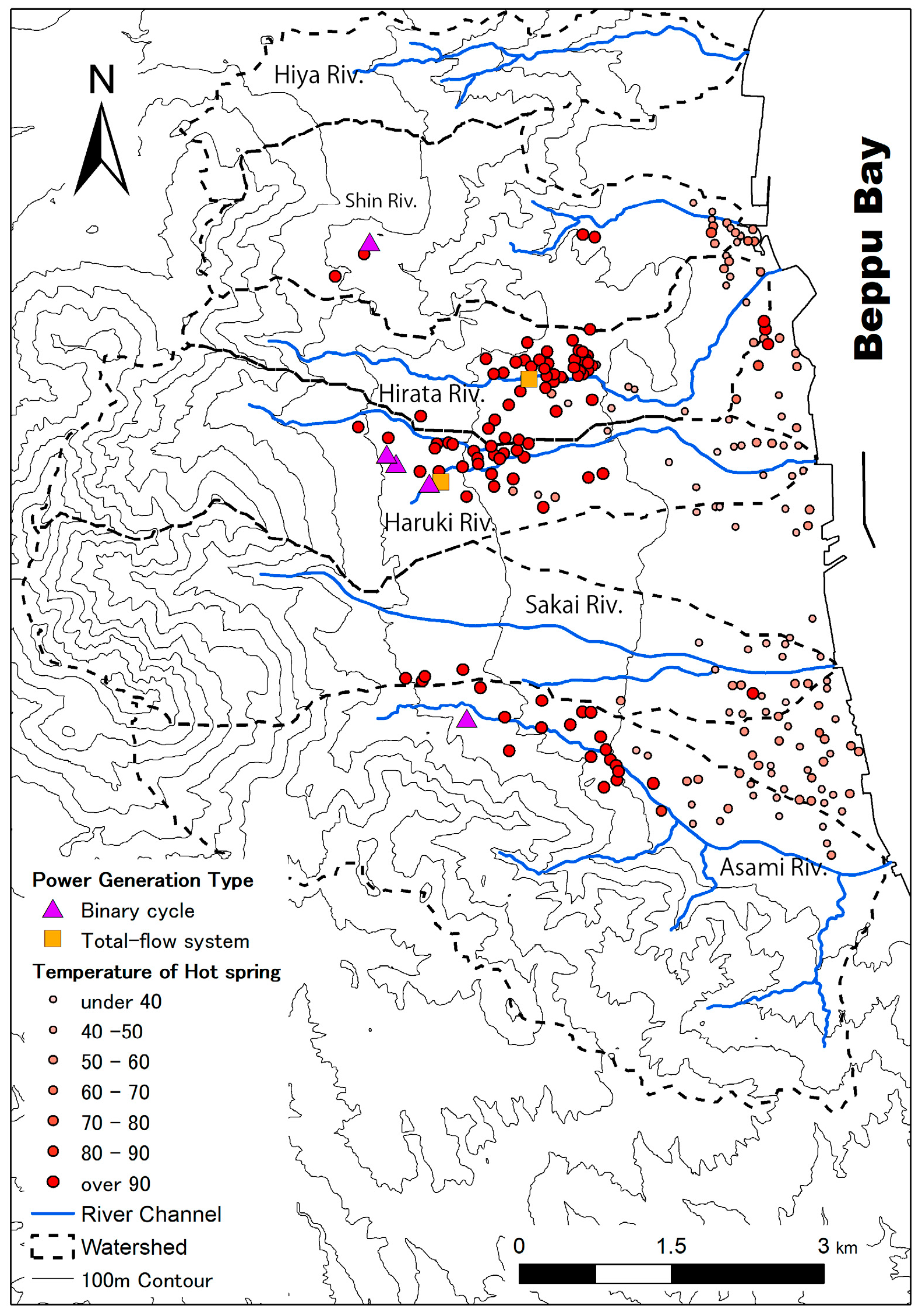
A map development team consisting of five experts from the RIHN nexus project in different disciplines, including hydrology, hot spring studies, environmental economics, fisheries economics, computer science, social network analysis, and policy studies, held a series of eleven group discussions between 2016 and 2018. They integrated, developed, and settled the discussion regarding the selection of methods, the development of the selected methods, and the integration of the methods. As a result, five steps were identified for creating a nexus domain ontology, including its database and the system map. The first involved drawing causal linkages between WEF resources and their stakeholders in social and natural systems. Through discussions with experts, this identified the system boundaries addressed by the five teams, in order to confirm what systems we covered in the human–nature system for a site-specific case study from Beppu, Ōita Prefecture, Japan. The second step involved describing a target WEF nexus domain world by generating the terms, concepts, and semantics of the WEF nexus system for enhancing the compatibility of qualitative descriptions logically or objectively, including quality, property (characteristic), whole-part, and attribute relationships using the ontology engineering method. The third step was to define the concepts and sub-concepts of trade-offs related to WEF via WEF nexus domain ontology, taking a qualitative approach. The fourth step involved quantifying and identifying key concepts serving as linkage hubs in the target WEF nexus domain ontology using the network analysis method. The fifth and final step was to develop WEF nexus system maps centered on key concepts identified using the network analysis method as an interdisciplinary tool.

2.2. Study Area

This project targeted the Beppu area at a local scale to address the trade-offs in water resource use between land activities for producing or consuming food and energy and coastal ecosystems, including fishery resources, based on the aforementioned project hypothesis. Beppu is located in a major hot springs area in Japan and is a city with a population of approximately 120,000 (2014). Its population continues to decline, having peaked in 1981, owing to its falling birthrate and aging population. Regarding topography, an alluvial fan gently spreads from west to east. Hot springs originating at Mt. Tsurumi in western Beppu flow to the urban sectors. The hot spring water has a higher temperature in the mountainous areas than in the lowlands. Ōita Prefecture has ranked first in terms of the total amount of hot spring discharge points and spring water sources, and Beppu City has ranked first in the overall quantity of discharged hot spring water in the prefecture. In addition, the utilization of hot springs has been changing greatly in recent years; after the introduction of the feed-in tariff scheme for renewable energy in 2012 in Japan, geothermal energy development was initiated in Beppu. The Hiya, Shin, Hirata, Haruki, Sakai, and Asami Rivers flow into Beppu Bay, and household and hot spring drainage water with thermal energy from hot spring resorts and power generation run into each of these rivers, except the Hiya (Figure 1, Table 1).

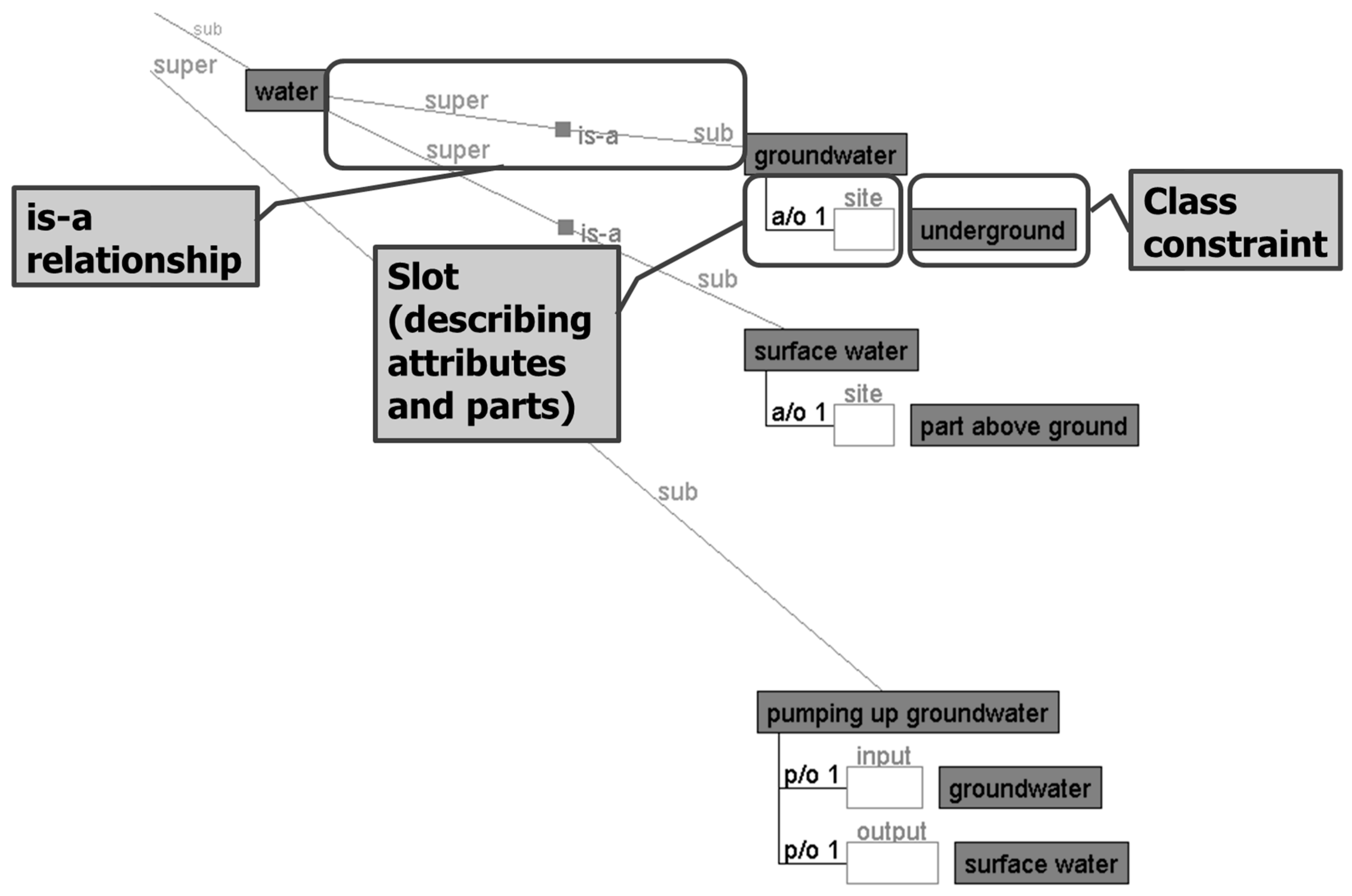
2.3. General Description of Ontology Engineering

Ontology engineering [21] is a base technology in Semantic Web technology, and a method for providing common terms, concepts, and semantics. Ontology engineering enables the description of super-sub, whole-part, and attribute relationships. The ontology engineering method has been utilized as a tool in environmental studies, such as the integrated assessment of agricultural systems [22], social ecological systems [23], sustainability science [24], and Sustainable Development Goals (SDGs) [25] in international academic communities.
By connecting these relationships, we can build a causal linkage that explicates a reasoning process. Ontology engineering designs a model through the deep consideration of entities. The term ontology traditionally refers to a “theory of being” in philosophy, but in this discussion, it is used in the context of ontology engineering in the knowledge engineering field. In this section, we describe a social–natural system by updating ontology with a focus on sustainability and environmental science domains, as proposed by Kumazawa et al. [24].
We explain ontology using the Hozo (http://www.hozo.jp/) ontology development tool developed by the Department of Knowledge Science at the Institute of Scientific and Industrial Research, Osaka University [26]. Hozo is based on the fundamental theories of ontology engineering for capturing the essential conceptual structure of the target world.
An ontology consists of concepts and relationships that are needed to describe the target world. One of the main components of an ontology is a taxonomic hierarchy of concepts representing things existing in the target world that are deemed important and organized by identifying the “is-a” relationships between them. The “is-a” relationship indicates the super-sub relationships, which means A is a specialized B, “A is a sort of B,” when <A is a B> in the relationship between A and B is true. Figure 2 shows such an “is-a” relationship in the statement “groundwater is-a water.” In this relationship, we call water a super-concept while groundwater is a sub-concept. These concepts are referred to as basic concepts, which means that the concepts are defined without referring to any other concepts and are called class concepts in Hozo.
The introduction of other relationships refines the definition of the concepts. For example, “part-of” and “attribute-of” relationships are used to show the concept’s parts and attributes, respectively, as in the case in which pumping up groundwater is represented by “part-of” relationships with groundwater and surface water. When there is an “is-a” relationship between two classes, its subclass inherits the properties (characteristics) of the super class, which indicate the “part-of” and “attribute-of” slots from its super class in Hozo. This is known as inheritance of properties (characteristics). In Figure 2, “input” or “output” includes context-dependent concepts, referred to as roles. The greatest characteristic of Hozo is the ability to deal with a role concept, which allows for the creation of a model to indicate what plays a particular role within a context. For example, humans, fruits, or heating oil can play the role of teachers, food, or fuel, respectively. In addition, the class concept, which can potentially play a role, is constrained by the role. Thus, concepts can be defined during the process of ontology building through inheritance and specialization.

2.4. General Description of Network Analysis

Network analysis is an analysis method that clarifies the relationship structure between various elements based on mathematical graph theory. In network analysis, the network is defined as a set of nodes and edges with some attributes. A node is represented as a connection point in a graph. For example, in social networks, nodes are made up of people and companies, biological species in food chain networks, and so on. Edges are represented as lines in the graph. An edge is a relationship between nodes; for example, edges can represent friendship or costarring relationships, business transactions, predation relationships in food chains, or protein–protein interactions. Networks can be divided into several types. In the general graph, loops of edges from the same node and multiple edges between nodes are allowed. Graphs not including these are classified as simple graphs. A network with equally related relationships among all nodes is defined as a one-mode graph. When a node is divided into two or more types of attributes and has a relationship only between different attributes, it is called an N-mode graph (where N is the number of attributes). It is a directed graph whose edge has direction, whereas an undirected graph has an edge with no direction. Edges can have weights that quantitatively express the strengths of relationships; such graphs are classified as weighted graphs. Network analysis consists of (1) identifying the node that is mainly the center of the network; (2) investigating the nature of the network structure, including its complexity; and (3) extracting a subgraph that has a characteristic network structure inside the network and so on, aimed at clarifying the characteristics of the network. There are many centrality indicators that can assist in discovering the central nodes that play important roles and functions in the network. As representative indicators, (1) degree centrality is evaluated as the centrality of nodes acquiring many edges, (2) closeness centrality is a node at a position that can be connected to other nodes at the shortest distance, and (3) betweenness centrality is evaluated centering on the node located on the shortest path connecting many nodes [27]. The network analysis method has also been applied to identify key actors and visualize network maps in WEF nexus domain worlds [28,29].

3. Results

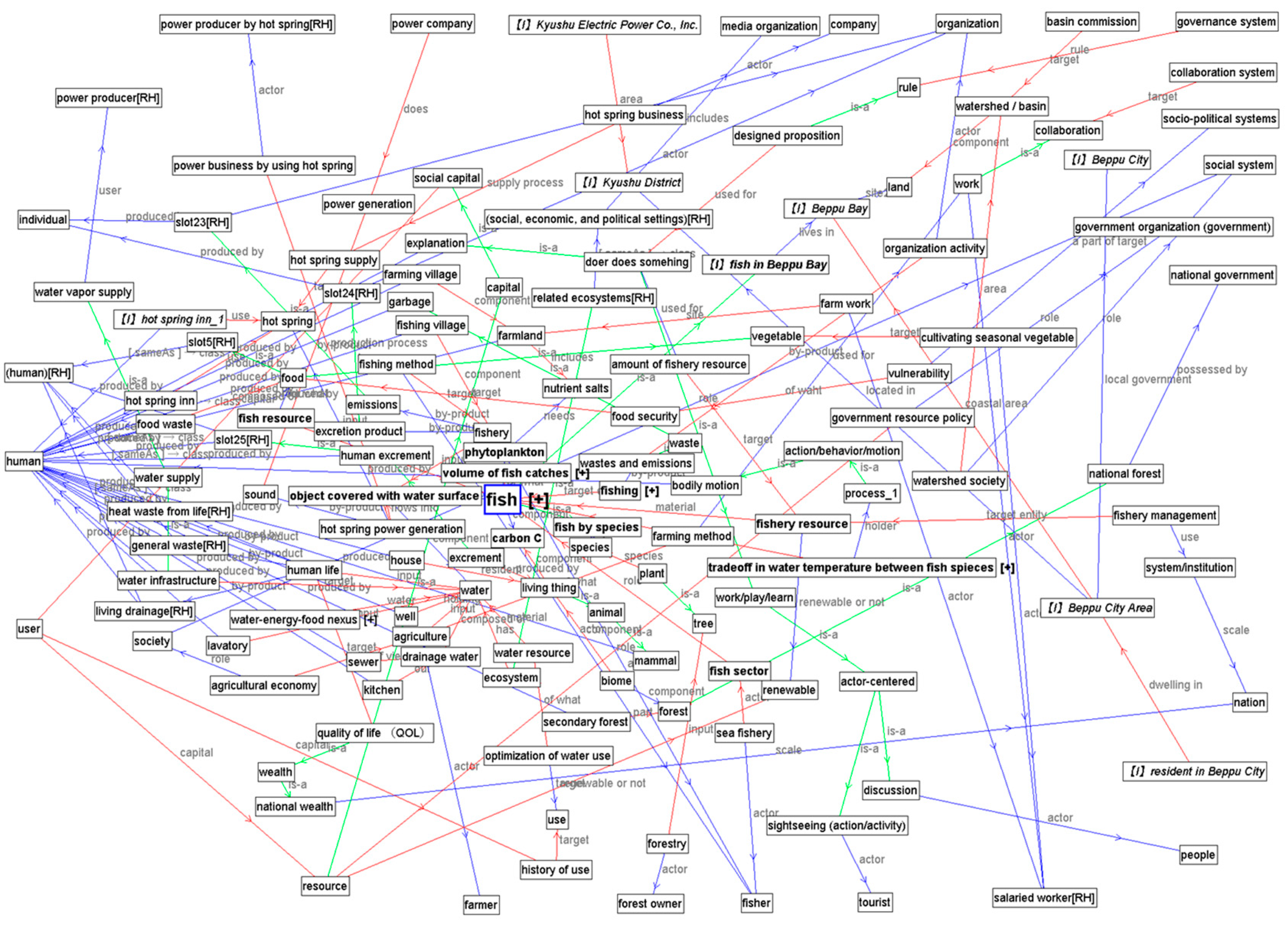
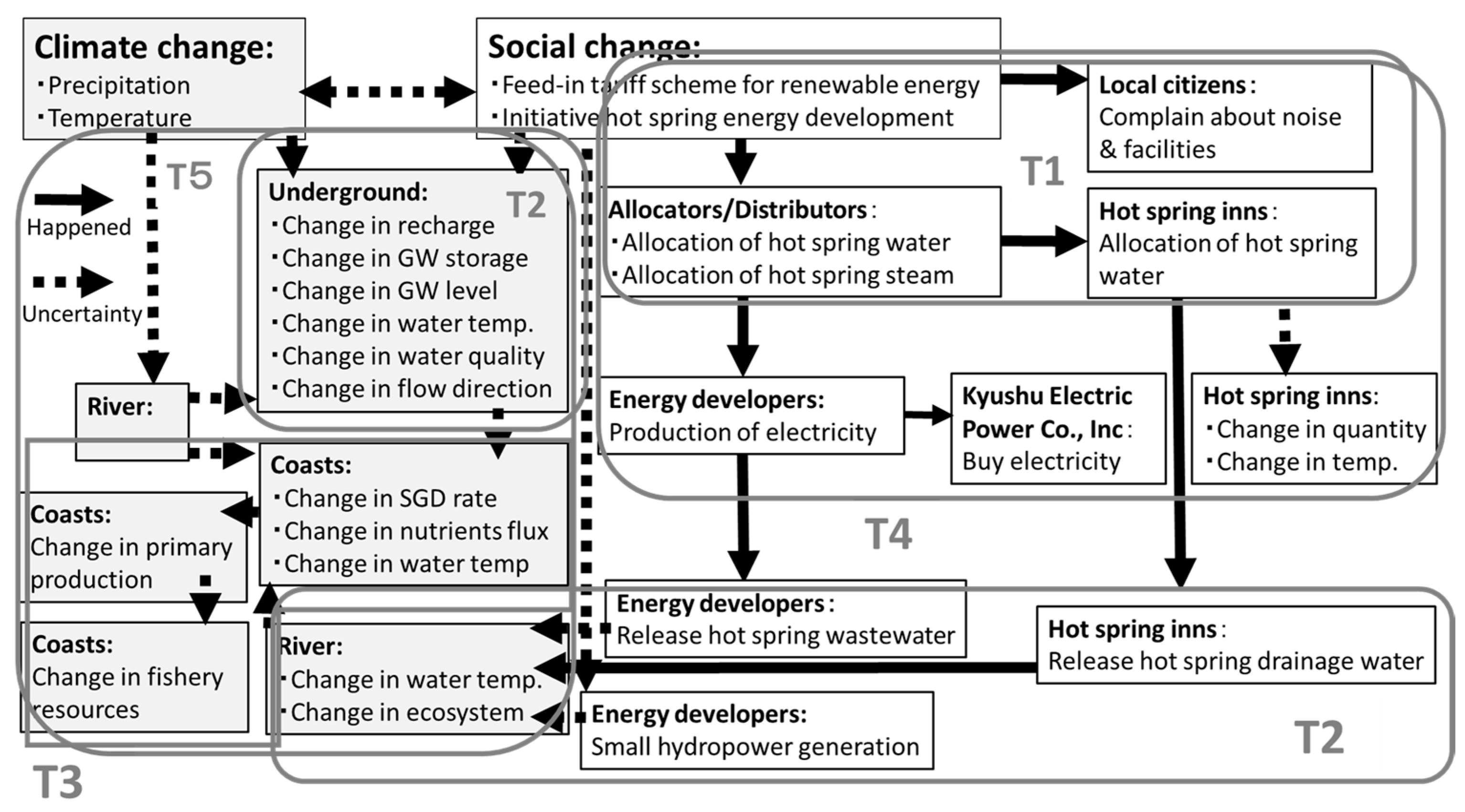
3.1. Drawing Causal Linkages between WEF Resources and Their Stakeholders in Social and Natural Systems

We sorted events in connection with the WEF nexus in the Beppu area, described the connection of these events notionally, and—through discussions with leaders of each team at regular team leader meetings in our project’s first step—identified each team’s targeted boundary of the systems affecting the project addressed in Beppu. In particular, natural systems such as underground and river systems (covered by water–energy nexus team: T2); coastal systems, including ecosystems (addressed by the water–food nexus team: T3); and social systems, including stakeholders such as national and local governments, local citizens, hot spring resorts, energy developers, and the Kyushu electric power company (addressed by the stakeholder analysis team: T4). The sociocultural team (T1) studied the cultural significance of hot spring management and its history, and the interdisciplinary studies team (T5) developed the methods to link terrestrial and marine systems, including a model and a map, working with other teams (Figure 3).
Against the backdrop of climate and social change, and the enactment of measures such as the Feed-in Tariff scheme for renewable energy initiated in 2012 and hot spring energy development in 2013, increased pumping of hot spring water may influence the underground environment and processes such as groundwater recharge, storage, level, temperature, quality, and flow direction, and may even change these conditions. Subsequently, this would cause changes in the broader coastal environment, including the submarine groundwater discharge (SGD) rate, nutrient input, seawater temperature, primary production, and fishery resources. Meanwhile, the recently initiated development of hot spring energy has led to local citizens’ anxiety regarding the noise generated by facilities. In addition, such development would cause changes in the allocation of hot spring water, which causes concern on the part of hot spring resorts regarding the hot spring water resources, including quality, quantity, and temperature. Furthermore, the increase in hot spring wastewater from energy developers would lead to changes in river ecosystems in terms of water quality, quantity, and temperature.
However, Figure 3 is only partial, containing selective or subjective representations of the connection. Also, the figure does not sufficiently describe or visualize the linkages between the parts and the whole system, including natural and social systems; therefore, the trade-off relationships of attributes are not specifically described. Ontology engineering is one method of practically providing a logical and objective description of the linkage structure of natural and social phenomena in a target domain.

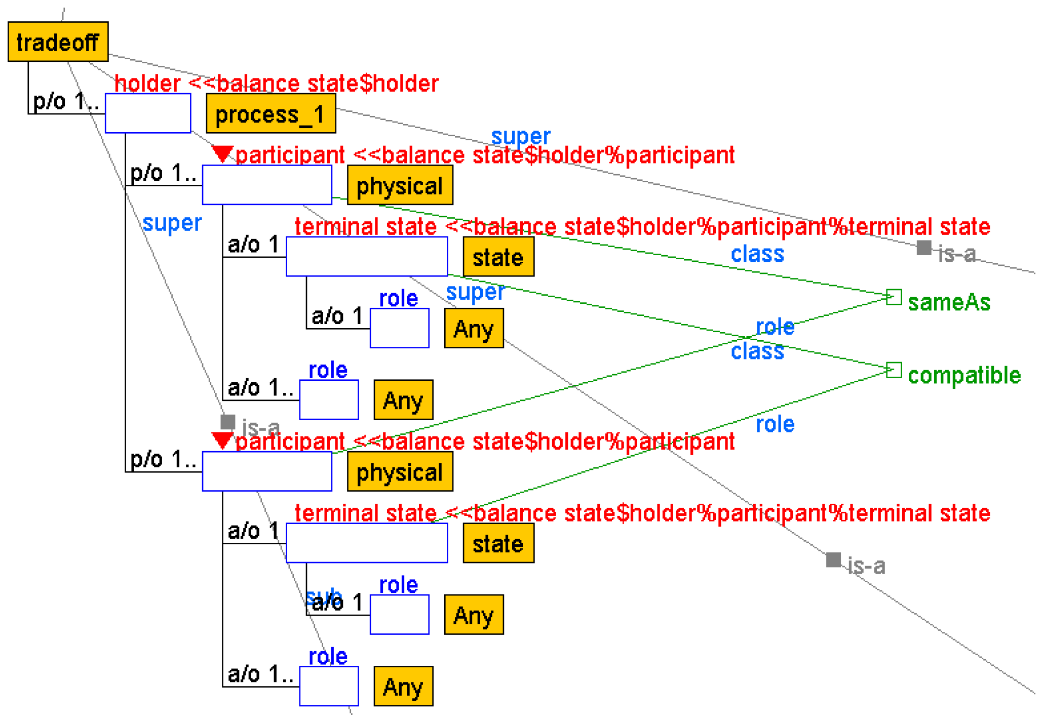
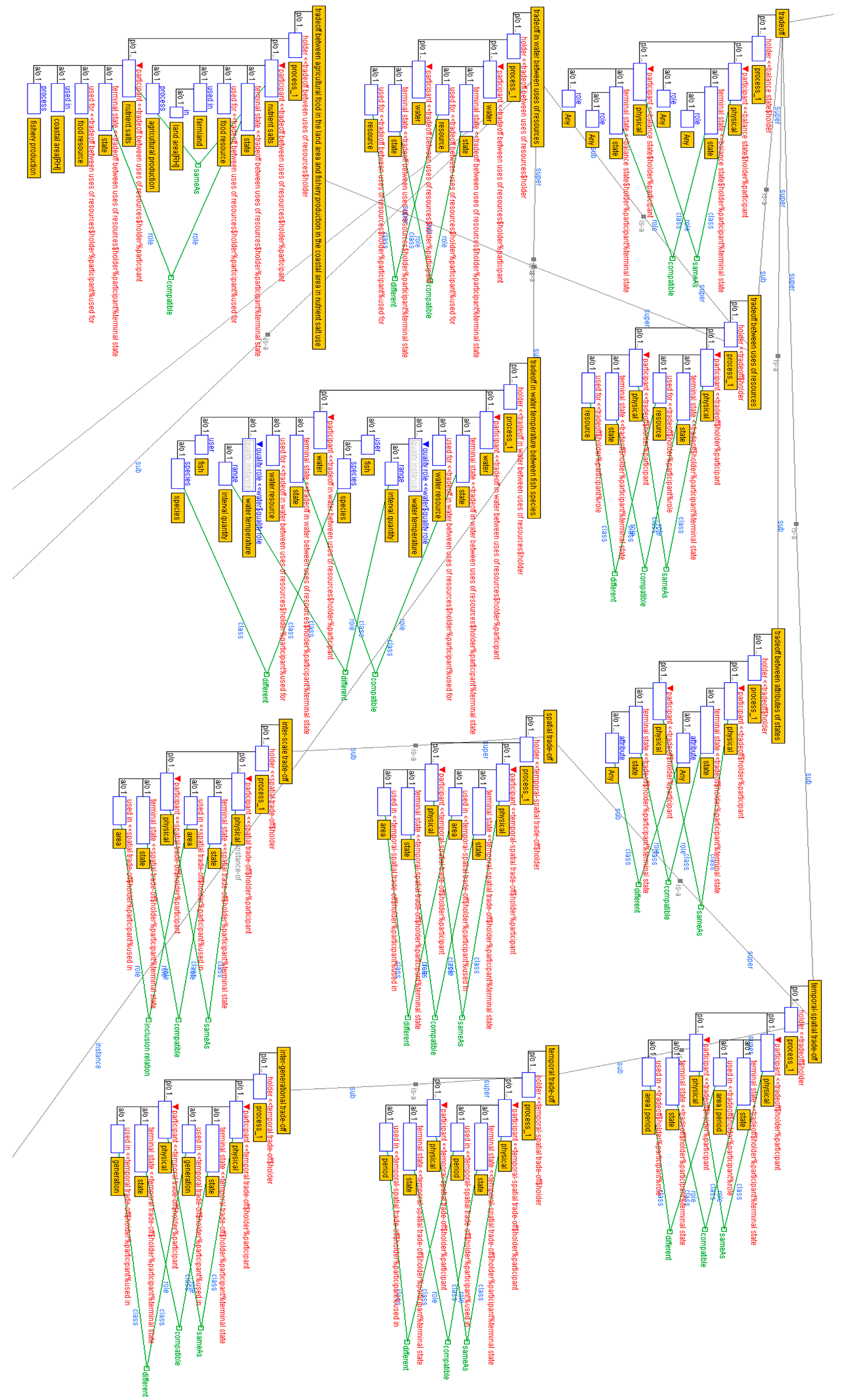
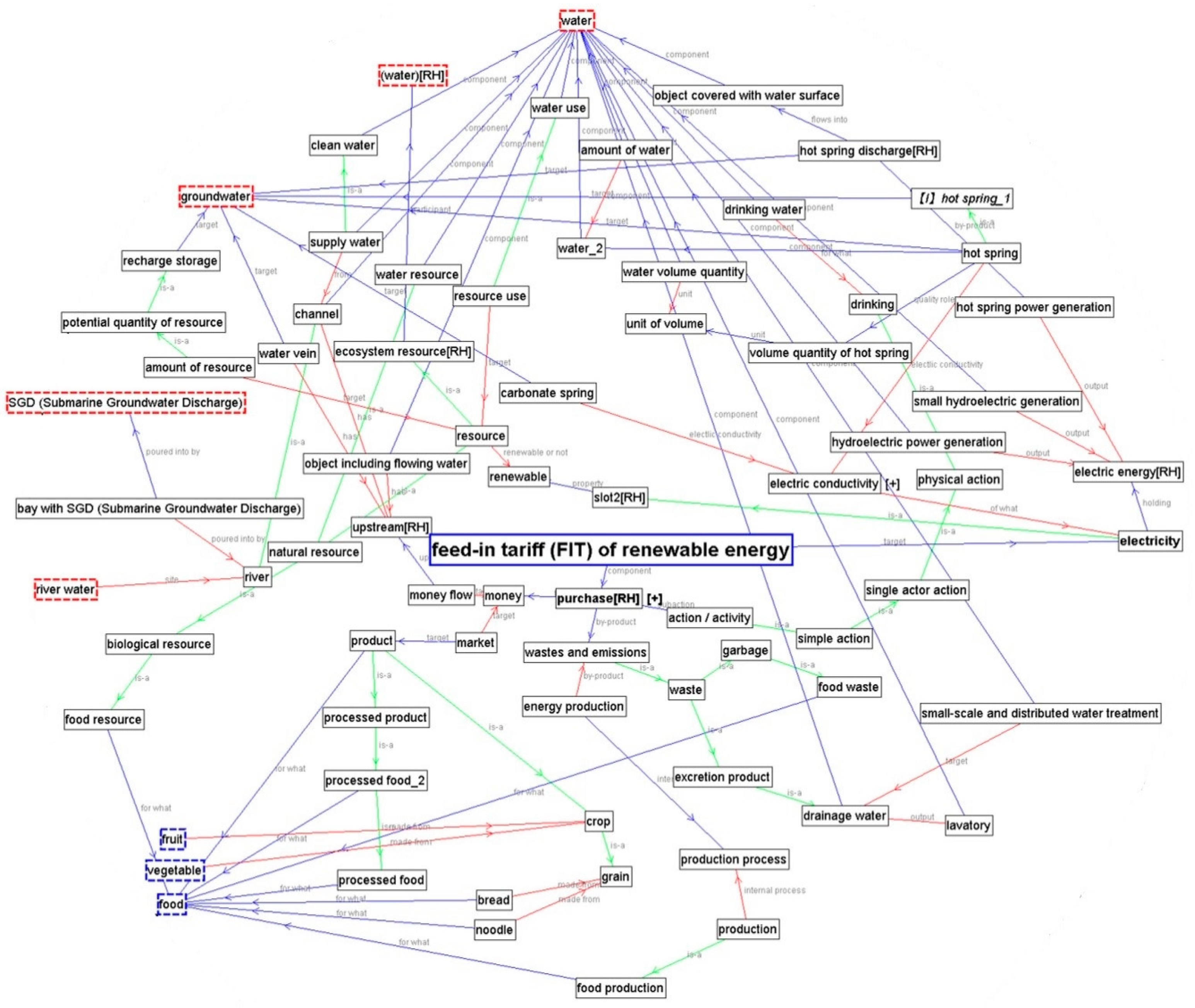
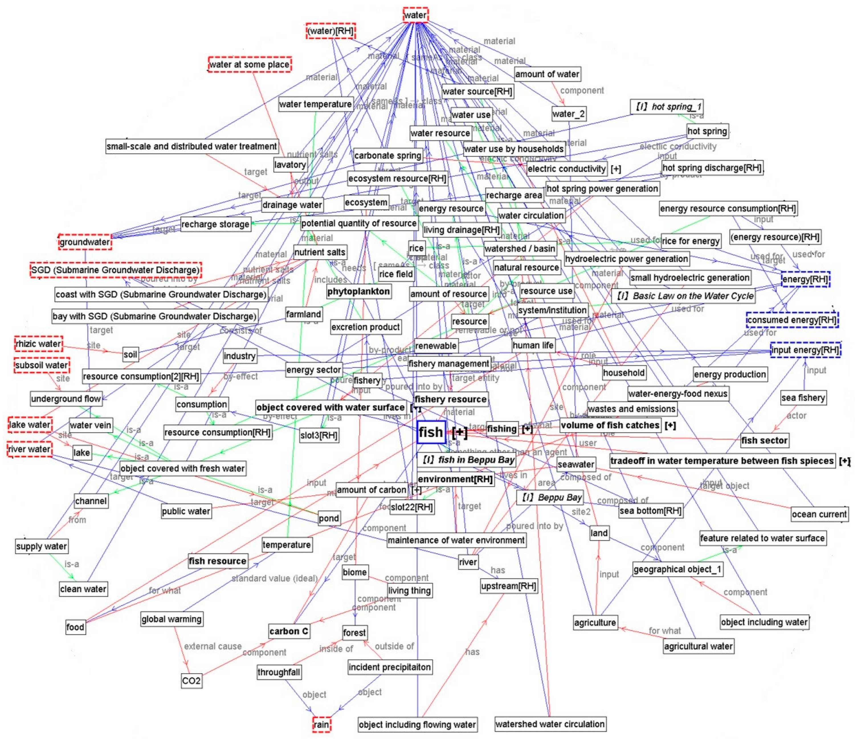
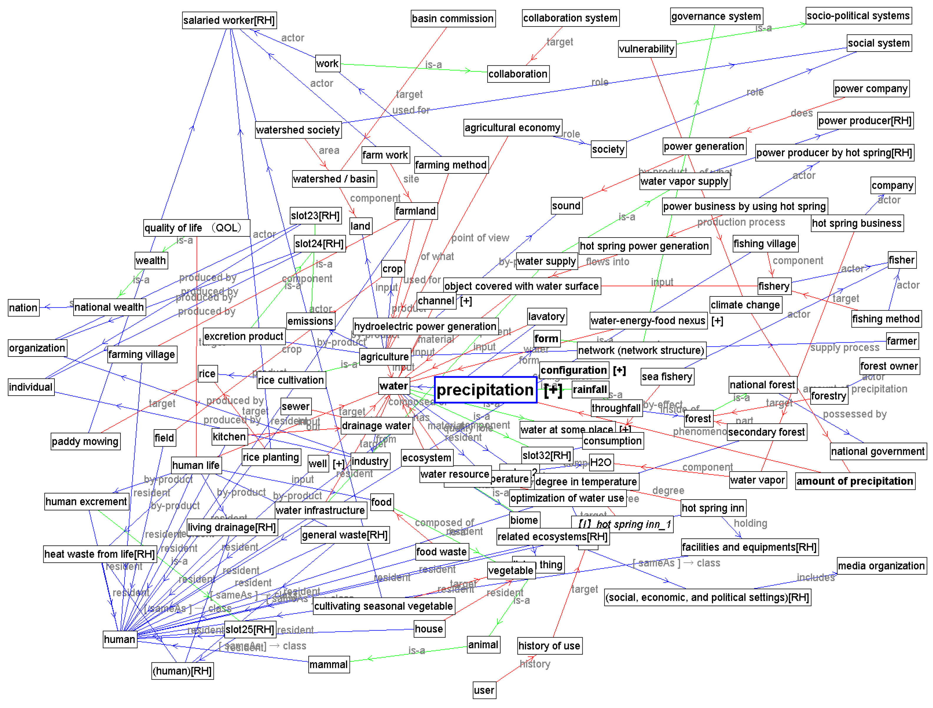
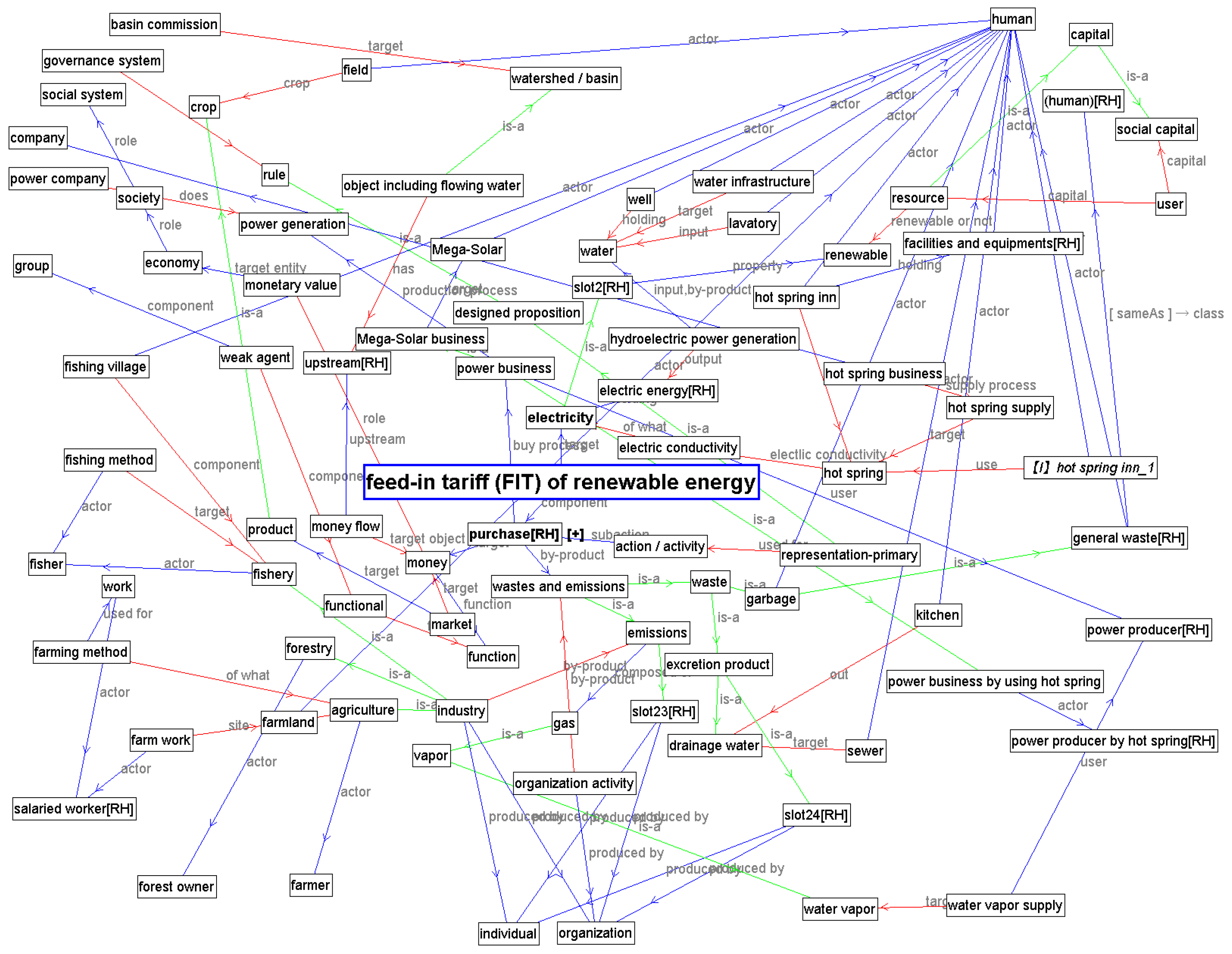
3.2. Describing WEF Nexus Domain Ontology Including Defining the Concepts and Sub-Concepts of Trade-Offs Relating to WEF

In this subsection, we first define the concepts related to the Beppu case in the target ontology based on Figure 3. Using this WEF nexus domain ontology enabled us to describe causal linkages between concepts when discussing the WEF nexus issues in the Beppu case. To describe the WEF nexus domain ontology, we introduced a top-level ontology called YAMATO [31,32] as a basic structure. Following this top-level ontology, we divided the concepts in the nexus domain ontology into entity, dependent entity, and substrate. Second, we divided the entities using the concepts “abstract”, “semi-abstract” (indicating a semi-abstract object), and “physical” (indicating a physical object); physical objects were classified as continuant or occurrent. The sub-concepts of physical objects classified as “continuant”, whose parts are all identifiable, were labeled “unitary”; these can be further classified as “objective” or “dissective” sub-concepts. Physical objects that were classified as “occurrent” were divided further into the concepts of “process”, “event”, and “state”. Furthermore, all kinds of actors identified in Figure 3 were defined as sub-concepts of agent, which is itself a sub-concept of object. The concept tree for the top-level ontology, which includes trade-off-related concepts, is visible in the nexus domain ontology (Figure 4).
As a next step, we defined the concept of trade-off to understand the WEF nexus system, as shown in Figure 5. The term trade-off is defined in the Oxford English Dictionary as “a balance achieved between two desirable but incompatible features; a compromise.” Following this definition, trade-off was defined as a sub-concept of state, as shown in Figure 4. To prepare for designing the trade-off concept, we first discussed the structure of the process concept. In some cases, a process was held by a participant. Process_1 in the process sub-concept corresponded to this kind of process. Meanwhile, the concept of state was classified into object state and process state. Object state is held by a continuant, while process state is held by a process. Trade-off is a kind of balance state at the sub-concept of process state. Balance state is held by process_1 because it inherits the structure of process state and focuses on the process held by a participant. Trade-off also inherits the structure of the balance state, but the target participant is restricted to the physical (object). The core structure of trade-off is the compatible relationship between states. Such a trade-off state is derived from the difference between the attribute roles of states and/or the difference between the attribute roles of physical (objects). For example, trade-off between quality role and quantity role, as well as trade-off between water temperature degrees, are the cases of trade-off between the attribute roles of states. In this ontology, we defined such a concept as a sub-concept of trade-off and called it trade-off between attributes of states. Both temporal–spatial trade-off and trade-off between uses of resources target the trade-off between the attributes of physical objects, though they have different kinds of physical object attributes; each type of trade-off targets specific attributes of physical objects according to area and period, as well as use. In addition, temporal–spatial trade-off can be divided into temporal trade-off and spatial trade-off. Furthermore, inter-generational trade-off was defined in Endo et al. [33] as a sub-concept of temporal trade-off, while inter-scale trade-off was defined as a sub-concept of spatial trade-off (Figure 4, Figure 6).
In the lower hierarchy, we can find the concepts of trade-offs in the Beppu case, including trade-off in hot spring water between use by hot spring resorts and use in hot spring power generation, trade-off in water use between food and energy production in the land area and the ecosystem including fishery production in coastal areas, trade-off in water temperature between fish species, and trade-off between agricultural food in land areas and fishery production in coastal areas in nutrient salt use (Figure 4, Figure 6).

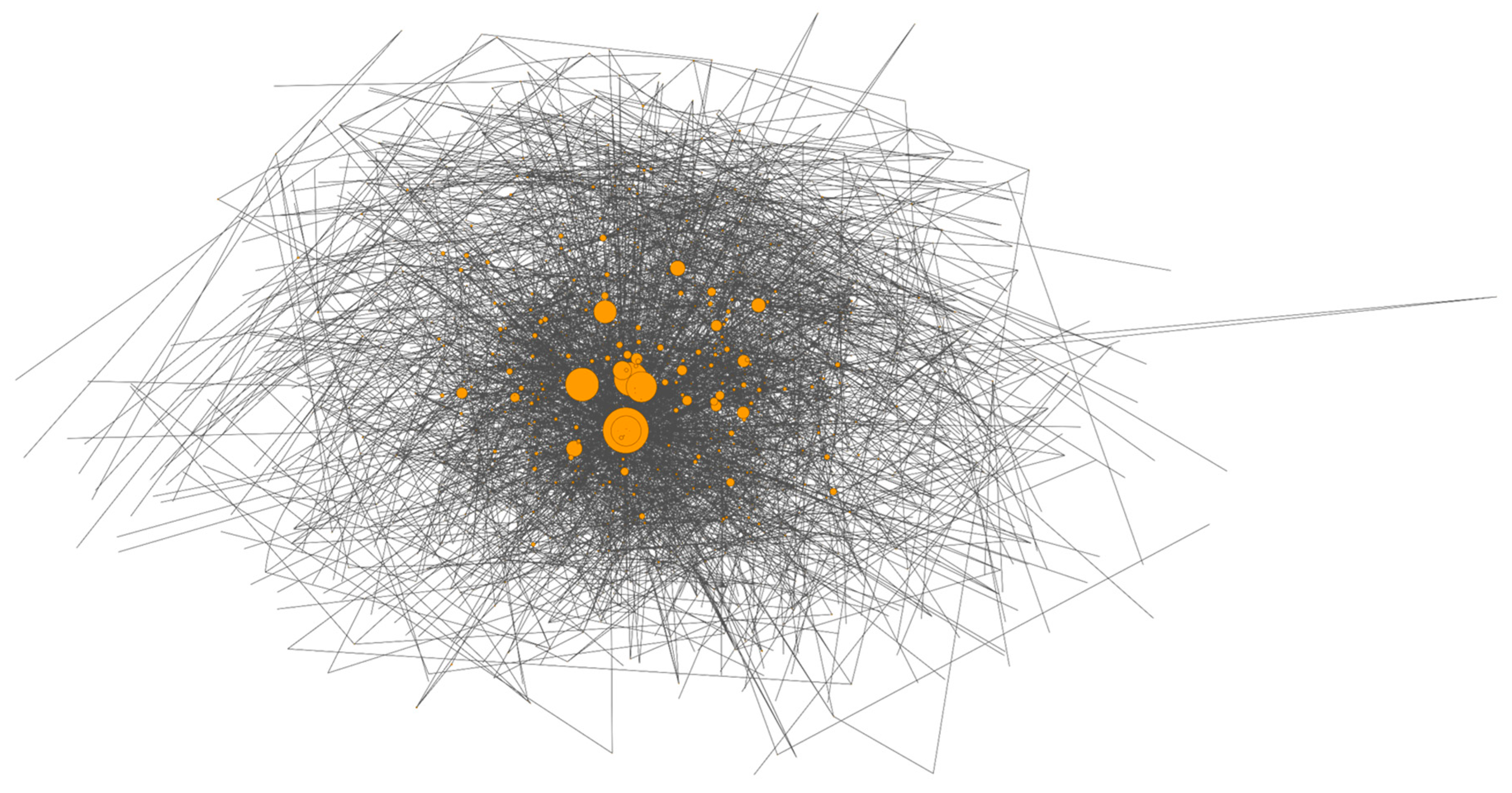
3.3. Quantifying and Identifying Key Concepts Being Linkage Hubs in the Target WEF Nexus Domain Ontology Using the Network Analysis Method

To clarify the relationship structure between concepts of the WEF nexus domain ontology quantitatively in the third step, we abstracted relationships such as is-a and their attributes and visualized them upon an undirected, weightless simple graph (Figure 7). The node size in Figure 7 shows the degree of betweenness centrality. A node with a large figure size indicates that betweenness centrality is high. In the WEF nexus domain ontology, the total number of nodes (number of concepts) was 1972, the total number of edges was 3076, the density was 0.00158, and the average distance was 6.72. The density index is the proportion of measured edges to the maximum number of possible edges in a network. For instance, the complete graph where edges exist between all the nodes, which is set as a standard, is 1. The average distance index shows the average distance of the shortest steps for reaching all the nodes. As a result, the WEF nexus domain ontology is a sparsity network with a low density index. Moreover, there are a small number of nodes with high betweenness centrality toward the center of the sample graph in Figure 6; however, a large number of nodes with low betweenness centrality exist toward the periphery of the figure. To identify the key concepts mediating between the concepts of different domains in the nexus domain ontology, we calculated the betweenness centrality of all the concepts; the top 50 concepts with high betweenness centrality are shown in Table 2.
We identified “precipitation”, “feed-in tariff (FIT) of renewable energy”, and “fish” as key concepts in the nexus domain ontology, which cross water, energy, and food domains, excluding general top-level concepts such as “target” and “object”. This indicates that these three concepts explain the distinctive features of the WEF nexus in Beppu.
In the next section, we visualize the linkages between the concepts of “precipitation”, “feed-in tariff (FIT) of renewable energy”, and “fish”, and the concepts relating to water, energy, and food, in order to understand the subsequent complexity of human–nature systems in the nexus domain.

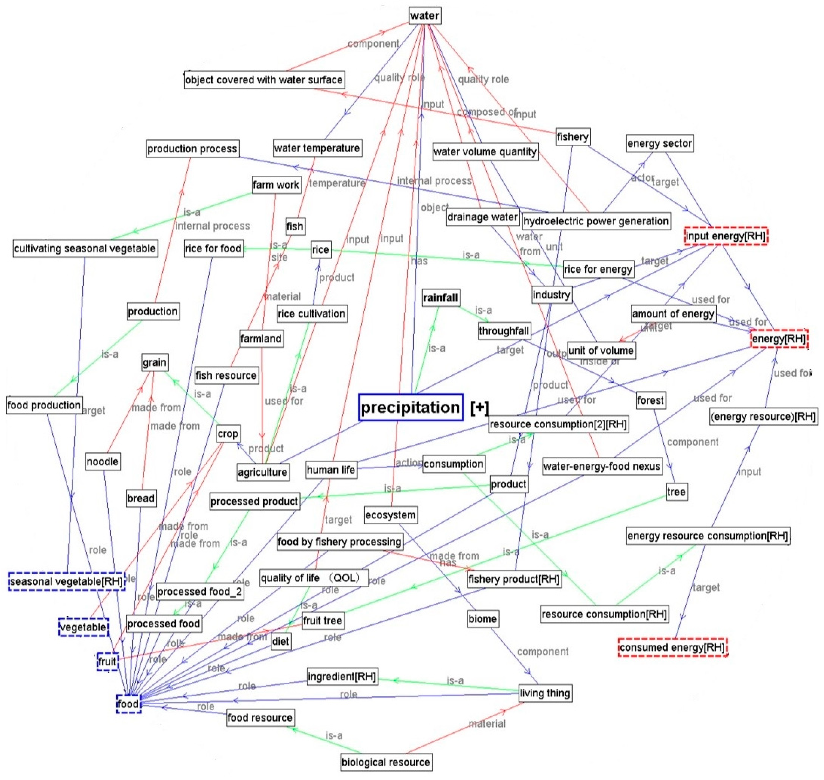
3.4. Designing and Visualizing WEF Nexus System Maps by Centering Identified Key Concepts

We developed the WEF nexus system map as an assistant tool for identifying relevant disciplines, experts, and stakeholders in order to view the problem as a system [8], visualize human–nature interactions as a complex whole, illustrate causal linkages between the concepts of water-energy-foods, and promote holistic thinking to view the problem inclusively in a larger context [8]. In the last step of the process of systems thinking and holistic thinking, we developed WEF nexus system maps using Hozo as a map development tool [34]. The conceptual map using Hozo explains “is-a”, “part-of”, and “attribute of” relationships, and was drawn from a particular point of view indicated by users by using a keyword exploration tool. In this study, we attempted to visualize the causal linkages of concepts between (A) “precipitation”, “feed-in tariff (FIT) of renewable energy”, and “fish”, which were identified as key concepts serving as linkage hubs in the WEF nexus domain ontology, and (B) water, energy, and food concepts in the nexus domain ontology. The map indicates (1) the domains, disciplines, and stakeholders between the paths linked from the starting-point to the terminal-point concepts; (2) the intersection nodes existing between different concepts, which are inherent in trade-off and/or potential trade-offs relationships; and (3) key concepts serving as linkage hubs in the WEF nexus system map.
Figure 8 shows the paths from ”precipitation” as a water concept, which was set as a starting point, to “energy” and “food” concepts as terminal points. The map shows that the concepts (nodes) of “water”, “input energy”, “energy”, and “food” created linkage hubs in the map and that each concept was interconnected with other water, energy, and food concepts comprehensively. The intersection nodes between the paths, which connected both energy and food concepts, are “rice”, “hydroelectric power generation”, “human life”, and “industry”, including “agriculture” and “fisheries”. Based on these intersection nodes, the trade-off in water use between food and energy production in the land area and the ecosystem, including fishery production in the coastal area (which is described in the nexus domain ontology in Figure 4), is visualized in the map.
Figure 9 shows the paths centering on the concept of the “feed-in tariff (FIT) of renewable energy” as an energy concept toward the concepts of “water” and “food”. The map shows that the concepts of “water”, “groundwater”, “food”, and “hot spring” are key concepts that serve as linkage hubs in the map. It also provides a visual representation of the complexity of the water, energy, and food concepts. The intersection nodes between the paths, which connected both water and food concepts, are “purchase”, “waste and emissions”, “waste”, “money”, and “resource”. One of the characteristics of this map is that it covers economic and financial domains linked with the concept of waste with centering concepts of money, market, and purchase. Judging from these intersection nodes, the trade-off in hot spring water between hot spring resort and hot spring power generation, which is described in the nexus domain ontology (Figure 4), is visualized.
Figure 10 shows the WEF nexus system map, with the paths between the concept of “fish” as a food concept and the concepts of “water” and “energy”. This map contains the most complicated system among the three maps. One reason for this is that the concepts regarding fish in the lower hierarchy of the nexus domain ontology are well described. The concepts of “water”, “groundwater”, and “energy” are identified as linkage hubs in the map. The intersection nodes between the paths, which connect both water and energy concepts, are shown on the map as “nutrient salts”, “farmland”, “resource”, “human life”, “food”, “land”, “agriculture”, “carbon C”, “object covered with water surface”, “hot spring power generation”, and “fishery”. On the basis of these intersection nodes, the trade-off between agricultural food in the land area and fishery production in the coastal area in nutrient salt use, as well as the trade-off in water use between food and energy production in the land area and the ecosystem—including fishery production in the coastal area, which is described in the nexus domain ontology (Figure 4)—are represented visually.

4. Discussion

4.1. Nexus System Map Focusing on Human–Nature Interaction

One of the challenges in developing the WEF nexus system map was to make the relevant stakeholders visible, in response to the constituent parts of the problem in visualizing human–nature interactions as a complex whole. When we created the WEF nexus system map centering on key concepts identified by the network analysis method—such as precipitation–energy–food, feed-in tariff (FIT) of renewable energy–water–food, and the fish–water–energy nexus system maps—we recognized that (1) the majority of the nodes in the map described concepts relating to natural systems, and, therefore, (2) it is difficult to visualize stakeholders and human society–nature interactions in the map. After consideration by the map development team, we determined there could be two reasons that the human and social parts of the WEF nexus system are not well visualized in the case of the Beppu map. First, we were not able to describe and define the concepts of human society as parts interconnecting with the natural system in the WEF nexus domain ontology, because of uncertain scientific evidence regarding the linkage structure of natural and social phenomena in this target world. In addition, we lacked information, data, and knowledge concerning the target domain, including a lack of resources. Second, the WEF nexus system could be described without significant interactions between nature and human beings or between nature and human society, on the assumption that the developed nexus domain ontology would be already well explicated. In this case, the linkage structure of natural phenomena could be in keeping with or without human–nature interactions in this case study. However, in the case of a “second nature”—which means a natural environment is kept and managed via interacting human activities that generate well-governed commons—it would be possible to describe human–nature interactions clearly in the target world. Such activities would be important for understanding and managing human, social, and natural systems.

4.2. Potential Use of the Nexus System Map

Based on the discussions above, we re-created the WEF nexus system maps with a focus on human beings and society to visualize human–nature interactions in the WEF nexus system as a potential tool for a science–policy–society interface. One of the characteristic functions of Hozo, as a map development tool based on a database, is that users can choose a natural-language concept via a keyword exploration tool as a focal point and terminal point from the perspectives of their different interests, disciplines, and sectors, among other factors, and can draw a path between these concepts. In this case, we visualized the causal linkages between (A) “precipitation” (Figure 11), “feed-in tariff (FIT) of renewable energy” (Figure 12), and “fish” (Figure 13), set as respective starting points, and (B) agents such as “social system”, “governance system”, “social-political systems”, “political system”, “organization”, “group”, “individual”, and “human” as terminal points.
We will not discuss the features of each map in this section; rather, we suggest potential uses for the nexus system map. First, the map could be used at the initial stage for organizing the project: (1) to design the structure of the team and boundaries of each team across different disciplines; (2) to establish a common platform by building a list of common concepts from different disciplines among the members of the project; (3) to decide research questions and topics by finding unexpected paths of the concepts across different domains, disciplines, targeting resources, and stakeholders in response to the parts; and (4) to stimulate ideas among team members and stakeholders that could lead to links between team members, between stakeholders (including practitioners), and between both team members and stakeholders in order to promote knowledge interoperability between science, society, and policy as boundary objects. For example, the WEF nexus system map could be applied to economic methods, such as cost-benefit analysis (CBA); in fact, the first stage of CBA is “to determine which stakeholders will be included in the analysis” [35], followed by quantification procedures for benefits and costs. Although the quantification procedures are rigorously defined based on economic theories, the stakeholder identification stage is rather ad hoc. Finding possible trade-offs from the developed WEF nexus system map can provide valuable information for stakeholder identification during CBA. Meanwhile, it is ideal to apply the tool at the policy planning stage or at the end of the project in order to validate the policy, strategy, and plans, and to evaluate whether the projects addressed the problems that needed to be solved and the targeted disciplines, resources, stakeholders, and sectors. Furthermore, the tools could be used together as an educational device for improving systems thinking skills and for training systems thinkers.

5. Future Directions

The linked concepts, including causal linkages and trade-off relationships in the nexus domain world, are stored in the WEF nexus domain ontology database. However, the WEF nexus system described herein was developed to demonstrate a more water-centered trade-off. Although it would be possible to transfer this combined quantitative and quantitative method to other study areas to describe the complexity of the WEF nexus system in other target worlds, further research is needed. First, it is necessary to improve the developed nexus domain ontology, using other case studies to describe the concepts and sub-concepts of different types of trade-offs, such as trade-offs between the attributes of states, temporal-spatial trade-offs, and trade-offs between uses of resources. Second, regarding methodology, we found that the network analysis method can be used to analyze and evaluate the domain ontology of a target world in a quantitative way. Furthermore, combining other methods to visualize the strength and length of linkages between concepts (nodes), including on a temporal scale, is required to predict future events to address scientific uncertainty. Third, with regard to the technical functions of Hozo as a map development tool, there is still room for improvements, such as categorizing concepts with colors and visualizing not only “is-a”, “part-of”, and “attribute of” relationships, but also other relations described in the WEF nexus domain ontology. This would allow the WEF nexus domain ontology and map developed in this study to become not only an interdisciplinary tool, but also a science–policy–society interface for establishing an open platform.

Author Contributions

This study was conducted by the WEF nexus system map development team consisting of A.E., T.K., M.K., M.Y., T.K., and K.K. A.E. applied and adopted the concepts of interdisciplinary studies and an integrated approach for developing the WEF nexus domain ontology and the WEF nexus system map, and contributed to the Introduction, Materials and Methods, Results, Discussion, and Future Direction sections. T.K. described the WEF nexus system domain ontology and the map using the ontology engineering method, and contributed to the Materials and Methods, Results, and Discussion sections. M.K. applied the network analysis tool in the integration of the ontology engineering method and contributed to the Materials and Methods and Results sections. M.Y. helped develop the WEF nexus domain ontology and the map based on an Object-Oriented Concept and contributed to the Materials and Methods and Results sections. T.K. discussed the potential use of the map for promoting stakeholder involvement from an economic point of view and contributed to the Discussion section. Lastly, K.K., an expert in ontology engineering and Hozo programming, contributed to the upgrading of Hozo’s map-development functions. Although A.E. conceived of the study, the research was conducted by the WEF nexus system map development team under the RIHN WEFN project. To assess human environmental security, the team aimed to develop integrated methods to synthesize and harmonize each project member’s discipline and set of research skills.

Funding

This work was conducted under the project “Human Environmental Security in Asia-Pacific Ring of Fire: Water–Energy–Food Nexus” (No. 14200097), funded by the Research Institute for Humanity and Nature (RIHN). After the project ended in March 2018, this work was partially supported by Program 2, “Fair Use and Management of Diverse Resources”, funded by the RIHN.

Conflicts of Interest

The authors have no conflicts of interest to declare.

References

  1. Hoff, J. Understanding the nexus. In Background Paper for the Bonn 2011 Conference: The Water, Energy and Food Security Nexus, Bonn, Germany, 16–18 November 2011; Stockholm Environment Institute (SEI): Stockholm, Sweden, 2011. [Google Scholar]
  2. Keskinen, M. Bringing Back the Common Sense? Integrated Approaches in Water Management: Lessons Learnt from the Mekong. Ph.D. Thesis, Aalto University, Helsinki, Finland, 3 September 2010. [Google Scholar]
  3. WCED. Our Common Future, World Commission on Environment and Development (WCED); Oxford University Press: Oxford, UK, 1987. [Google Scholar]
  4. Margerum, R.D.; Born, S.M. Integrated environmental management: Moving from theory to practice. J. Environ. Plan. Man. 1995, 38, 371–392. [Google Scholar] [CrossRef]
  5. Mitchell, B. Integrated water management. In Integrated Water Management: International Experiences and Perspectives; Belhaven Press: London, UK, 1990. [Google Scholar]
  6. Klein, J.T.; Newell, W.H. Advancing interdisciplinary studies. In Handbook of the Undergraduate Curriculum: A Comprehensive Guide to Purposes, Structures, Practices, and Change; Jossey-Bass: San Francisco, CA, USA, 1997. [Google Scholar]
  7. National Academy of Sciences, National Academy of Engineering and Institute of Medicine. Facilitating Interdisciplinary Research; National Academic Press: Washington, DC, USA, 2005. [Google Scholar]
  8. Repko, A.F.; Szostak, R. Interdisciplinary Research: Process and Theory; SAGE: Thousand Oaks, CA, USA, 2008. [Google Scholar]
  9. Bazilian, M.; Rogner, H.; Howells, M.; Hermann, S.; Arent, D.; Gielen, D.; Steduto, P.; Mueller, A.; Komor, P.; Tol, R.S.; et al. Considering the energy, water and food nexus: Towards an integrated modelling approach. Energy Policy 2011, 39, 7896–7906. [Google Scholar] [CrossRef]
  10. Harwood, S. In search of a (WEF) nexus approach. Environ. Sci. Policy 2018, 83, 79–85. [Google Scholar] [CrossRef]
  11. Bizikova, L.; Roy, D.; Swanson, D.; Venema, H.D.; McCandless, M. The Water–Energy–Food Security Nexus: Towards a Practical Planning and Decision-Support Framework for Landscape Investment and Risk Management; The International Institute for Sustainable Development (IISD): Winnipeg, MB, Canada, 2013. [Google Scholar]
  12. Climate and Earth System Modeling: Integrated Assessment Research. Available online: https://climatemodeling.science.energy.gov/program/integrated-assessment-research (accessed on 28 January 2018).
  13. Kling, C.L.; Arritt, R.W.; Calhoun, G.; Keiser, D.A. Integrated assessment models of the food, energy, and water nexus: A review and an outline of research needs. Ann. Rev. Resour. Econ. 2017, 9, 143–163. [Google Scholar] [CrossRef]
  14. The Nexus between Energy, Food, Land Use, and Water: Application of a Multi-Scale Integrated Approach. Available online: http://www.nexus-assessment.info/ (accessed on 28 January 2018).
  15. Haberl, H.; Wiedenhofer, D.; Erb, K.-H.; Görg, C.; Krausmann, F. The material stock–flow–service nexus: A new approach for tackling the decoupling conundrum. Sustainability 2017, 9, 1049. [Google Scholar] [CrossRef]
  16. Yang, Y.C.E.; Wi, S. Informing regional water-energy-food nexus with system analysis and interactive visualizations: A case study in the Great Ruaha River of Tanzania. Agric. Water Manag. 2018, 196, 75–86. [Google Scholar] [CrossRef]
  17. Stirling, A.; Nexus Network Team; Science Policy Research Unit of University of Sussex Business School (SPRU); Social, Technological and Environmental Pathways to Sustainability (STEPS) Centre. Developing ‘Nexus Capabilities’: Towards Transdisciplinary Methodologies; The Nexus Network, Discussion Paper; University of Sussex: Brighton, UK, 2015. [Google Scholar]
  18. White, D.; Jones, J.; Maciejewski, R.; Aggarwal, R.; Mascaro, G. Stakeholder analysis for the food-energy-water nexus in Phoenix, Arizona: Implications for nexus governance. Sustainability 2017, 9, 2204. [Google Scholar] [CrossRef]
  19. Yusa, Y.; Kamiyama, K.; Kawano, T. Long-Term Change in Chemical Composition of Hot Spring in the Southern Part of Beppu Area; Reports of Oita Prefecture Hot Spring Research Society; Oita Prefecture Hot Spring Research Society: Oita, Japan, 1989. [Google Scholar]
  20. Yusa, Y.; Kamiyama, K.; Kawano, T. Long-Term Change in Chemical Composition of Hot Spring in the Northern Part of Beppu Area; Reports of Oita Prefecture Hot Spring Research Society; Oita Prefecture Hot Spring Research Society: Oita, Japan, 1990. [Google Scholar]
  21. Mizoguchi, R. Ontology Kougaku (Ontology Engineering); Ohmsha: Tokyo, Japan, 2005. [Google Scholar]
  22. Van Ittersum, M.K.; Ewert, F.; Heckelei, T.; Wery, J.; Olsson, J.A.; Andersen, E.; Bezlepkina, I.; Brouwer, F.; Donatelli, M.; Flichman, G.; et al. Integrated assessment of agricultural systems: A component-based framework for the European Union (SEAMLESS). Agric. Syst. 2008, 96, 150–165. [Google Scholar] [CrossRef]
  23. Frey, U.; Cox, M. Building a diagnostic ontology of social-ecological systems. Int. J. Commons 2015, 9, 595–618. [Google Scholar] [CrossRef]
  24. Kumazawa, T.; Kozaki, K.; Matsui, T.; Saito, O.; Ohta, M.; Hara, K.; Uwasu, M.; Kimura, M.; Mizoguchi, R. Initial design process of the sustainability science ontology for knowledge-sharing to support co-deliberation. Sustain. Sci. 2014, 9, 173–192. [Google Scholar] [CrossRef]
  25. Jansen, M. Sustainable development goals interface ontology. Presented at the International Conference on Biomedical Ontology and BioCreative (ICBO BioCreative 2016), Corvallis, OR, USA, 1–4 August 2016. [Google Scholar]
  26. Kozaki, K.; Kitamura, Y.; Ikeda, M.; Mizoguchi, R. Role oyobi kankei ni kansuru kisotekikousatsu ni motodsuku ontology kijyutsukankyou no kaihatsu. Trans. Jpn. Soc. Artif. Intell. (JSAI) 2002, 17, 196–208. [Google Scholar] [CrossRef]
  27. Luke, D.A. A User’s Guide to Network Analysis in R; Springer: New York, NY, USA, 2015. [Google Scholar]
  28. Stein, C.; Barron, J.; Moss, T. Governance of the Nexus: From Buzz Words to a Strategic Action Perspective; The Nexus Network, SPRU, Nexus Network Think Piece Series, Paper 003; University of Sussex: Brighton, UK, 2014. [Google Scholar]
  29. Kimura, M.; Masuhara, N.; Baba, K. Visualization of potential social network focusing on common recognition of small scale distributed geothermal power plant stakeholders in Beppu City, Oita Prefecture. Environ. Sci. 2017, 30, 325–335. [Google Scholar]
  30. Endo, A.; Kumazawa, T.; Yamada, M.; Kato, T. Design and visualization of water-energy-food nexus system and future design. J. Jpn. Soc. Water Environ. 2017, 40, 134–137. [Google Scholar]
  31. Mizoguchi, R. YAMATO: Yet Another More Advanced Top-Level Ontology. Available online: http://www.ei.sanken.osaka-u.ac.jp/hozo/onto_library/upperOnto.htm (accessed on 22 July 2018).
  32. Mizoguchi, R. Ontology Kougaku no Riron to Jissen (Theory and Practice of Ontology Engineering); Ohmsha: Tokyo, Japan, 2012. [Google Scholar]
  33. Endo, A.; Burnett, K.; Orencio, P.; Kumazawa, T.; Wada, C.; Ishii, A.; Tsurita, I.; Taniguchi, M. Methods of the water-energy-food nexus. Water 2015, 7, 5806–5830. [Google Scholar] [CrossRef]
  34. Hirota, K.; Kozaki, K.; Mizoguchi, R. Development of a conceptual map creation tool for overlooking ontologies. In Proceedings of the 22nd Annual Conference of the Japanese Society for Artificial Intelligence (JSAI 2008), Asahikawa, Japan, 11–13 June 2008; Available online: http://2008.conf.ai-gakkai.or.jp/program/paper-100387.html (accessed on 27 July 2018).
  35. Boardman, A.; Greenberg, D.; Vining, A.; Weimer, D. Cost-Benefit Analysis; Prentice Hall: Upper Saddle River, NJ, USA, 2010. [Google Scholar]
Figure 1. Distribution of hot springs and hot spring power plants with temperatures in six river basins of the Beppu area. Source: Yamada, M., based on the literature [19,20].
Water 10 01245 g001
Figure 2. An example of concept definition based on ontology engineering.
Water 10 01245 g002
Figure 3. Natural and social events and their linkages in Beppu, Japan; figure modified from the literature [30]. GW: groundwater; SGD: submarine groundwater.
Water 10 01245 g003
Figure 4. The concept tree of the top-level ontology, including trade-off related concepts, in the nexus domain ontology.
Water 10 01245 g004
Figure 5. The structure of the concept of trade-off in the water–energy–food (WEF) nexus domain ontology.
Water 10 01245 g005
Figure 6. The structure of the sub-concepts of trade-off in the nexus domain ontology.
Water 10 01245 g006
Figure 7. An undirected weightless simple graph of WEF nexus domain ontology analyzed by the network analysis method.
Water 10 01245 g007
Figure 8. The “precipitation”–energy–food nexus system map.
Water 10 01245 g008
Figure 9. The “feed-in tariff (FIT) of renewable energy”–water–food nexus system map.
Water 10 01245 g009
Figure 10. The “fish”–water–energy nexus system map.
Water 10 01245 g010
Figure 11. The “precipitation”–agent nexus system map.
Water 10 01245 g011
Figure 12. The “feed-in tariff (FIT) of renewable energy”–agent nexus system map.
Water 10 01245 g012
Figure 13. The “fish”–agent nexus system map.
Water 10 01245 g013
Table 1. Drainage water from different sources in Beppu.
TitleHot Spring Drainage WaterHousehold Wastewater
Hot Spring ResortsThermal Energy Development Facilities
Hiya River---
Shin River-
Hirata River
Haruki River
Sakai River--
Asami River
Source: Yamada, M.
Table 2. Top 50 betweenness centrality index in the water–energy–food (WEF) nexus domain ontology.
RankConceptBetweennessRankConceptBetweenness
1target379,333.226Site64,067.9
2object280,407.227Has63,392.9
3component276,689.928measuring63,378.8
4role254,024.729functional62,196.8
5domain focused concept251,314.430abstract56,684.1
6semi-abstract188,763.931special54,015.0
7state154,942.732form51,453.6
8unit131,655.933number of units50,284.2
9content123,350.634area49,837.8
10referring to114,516.535agent49,428.2
11resource unit101,276.336element (chemistry)48,594.2
12actor99,647.637process state44,789.6
13quantity98,957.538amount of resource43,279.7
14user92,928.139activity43,104.2
15property88,573.440feed-in tariff (FIT) of renewable energy42,512.5
16external state87,920.441large small42,486.4
17change_286,304.642generic quality (attribute)42,078.7
18location84,149.543domain concept42,017.3
19on what80,970.244dependent entity41,645.1
20precipitation78,896.545actor-centered41,513.0
21material77,961.246know40,699.9
22object state75,477.347fish40,122.5
23precipitation71,207.248used for40,003.2
24value67,767.149specially dependent39,220.3
25phenomena64,706.850artifact38,905.2
Source: Kimura, M.

