Article

How Unusual Was 2015 in the 1984–2015 Period of the North Cascade Glacier Annual Mass Balance?

Environmental Science, Nichols College, Dudley, MA 01571, USA
Water 2018, 10(5), 543; https://doi.org/10.3390/w10050543
Submission received: 8 March 2018 / Revised: 14 April 2018 / Accepted: 20 April 2018 / Published: 24 April 2018
(This article belongs to the Section Hydrology)

Abstract

:
In 1983, the North Cascade Glacier Climate Project (NCGCP) began the annual monitoring of the mass balance on 10 glaciers throughout the range, in order to identify their response to climate change. Annual mass balance (Ba) measurements have continued on seven original glaciers, with an additional two glaciers being added in 1990. The measurements were discontinued on two glaciers that had disappeared and one was that had separated into several sections. This comparatively long record from nine glaciers in one region, using the same methods, offers some useful comparative data in order to place the impact of the regional climate warmth of 2015 in perspective. The mean annual balance of the NCGCP glaciers is reported to the World Glacier Monitoring Service (WGMS), with two glaciers, Columbia and Rainbow Glacier, being reference glaciers. The mean Ba of the NCGCP glaciers from 1984 to 2015, was −0.54 m w.e.a−1 (water equivalent per year), ranging from −0.44 to −0.67 m w.e.a−1 for individual glaciers. In 2015, the mean Ba of nine North Cascade glaciers was −3.10 m w.e., the most negative result in the 32-year record. The correlation coefficient of Ba was above 0.80 between all North Cascade glaciers, indicating that the response was regional and not controlled by local factors. The probability of achieving the observed 2015 Ba of −3.10 is 0.34%.

1. Introduction

The annual glacier mass balance measurements are the most accurate indicators of short-term glacier response to climate change [1,2]. The World Glacier Monitoring Service (WGMS) [2,3] has recognized that the changes in glacier mass are a key aspect of glacier monitoring, providing important information for assessing climatic changes, water resources, and sea level rise, and they maintain the most extensive data set on global glacier mass balance. The WGMS has recognized the continuous long term programs with consistent measurement programs as reference glaciers [3], there were 42 present world-wide in 2017. This network has proven valuable, but in many areas the number of glaciers that are monitored are limited [3]. There are three reference glaciers in the conterminous United States, and all are found in the North Cascades. The South Cascade Glacier (Figure 1) is monitored by the USGS (United States Geological Survey), and the Columbia Glacier and Rainbow Glacier are monitored by the North Cascade Glacier Climate Project (NCGCP) [3].
The North Cascade region in the United States extends from the Snoqualmie Pass to the Canadian Border and contains more than 700 glaciers. Glaciers in the North Cascade Range are important to water resources in many of the watersheds in the range [4,5]. The 2015 hydrologic year in the Pacific Northwest of North America was exceptional for its warmth and negative glacier mass balance. Here we utilize the breadth of the mass balance record to examine the impact of climate on the glacier mass balance, and to place the exceptional 2015 mass balance year in context.
NCGCP was founded in 1983 in order to monitor 10 glaciers throughout the range and identify the response of the North Cascade Range (Washington) glaciers to regional climate change [6,7]. The annual observations include the mass balance, terminus behavior, glacier surface area, and accumulation area ratio (AAR). All of the annual mass balance (Ba), AAR, and terminus change data are reported annually to the WGMS.
The NCGCP has continued Ba measurements on seven original glaciers that still exist, namely: Columbia, Daniels, Ice Worm, Lower Curtis, Lynch, Rainbow, and Yawning, as well as on Easton Glacier and Sholes Glacier, which were added in 1990. The annual measurement have been discontinued on three glaciers, namely: Lewis Glacier, Spider Glacier [7], and Foss Glacier, after it separated into several distinct sections. The Foss Glacier is becoming increasingly difficult to access and time spent doing so is not of a sufficient value, given the rapid recent demise and imminent loss of the glacier. The mass balance records provide both a direct measure of glacier runoff to rivers in the region and an understanding of that relationship with climate change [5,7,8]. No single glacier is representative of all of the others. In order to understand the causes and nature of changes in the glacier surface mass balance throughout a mountain range, it is necessary to monitor a significant number of glaciers [9]. The glacier mass balance in the North Cascades varies because of the geographic characteristics, including the aspect, elevation range, accumulation sources, and distance from crest of the range. When combined with the South Cascade Glacier [9], the NCGCP network represents the highest density of long term direct measurement, more than 25 years, of glacier mass balance over a given mountain range. The National Park Service is monitoring the mass balance of four glaciers in the North Cascades—namely, Silver Creek, North Klawatti, Noisy Creek, and Sandalee—starting the program in 1993, which are not used in this study because the duration of study has been less than 25 years [8].

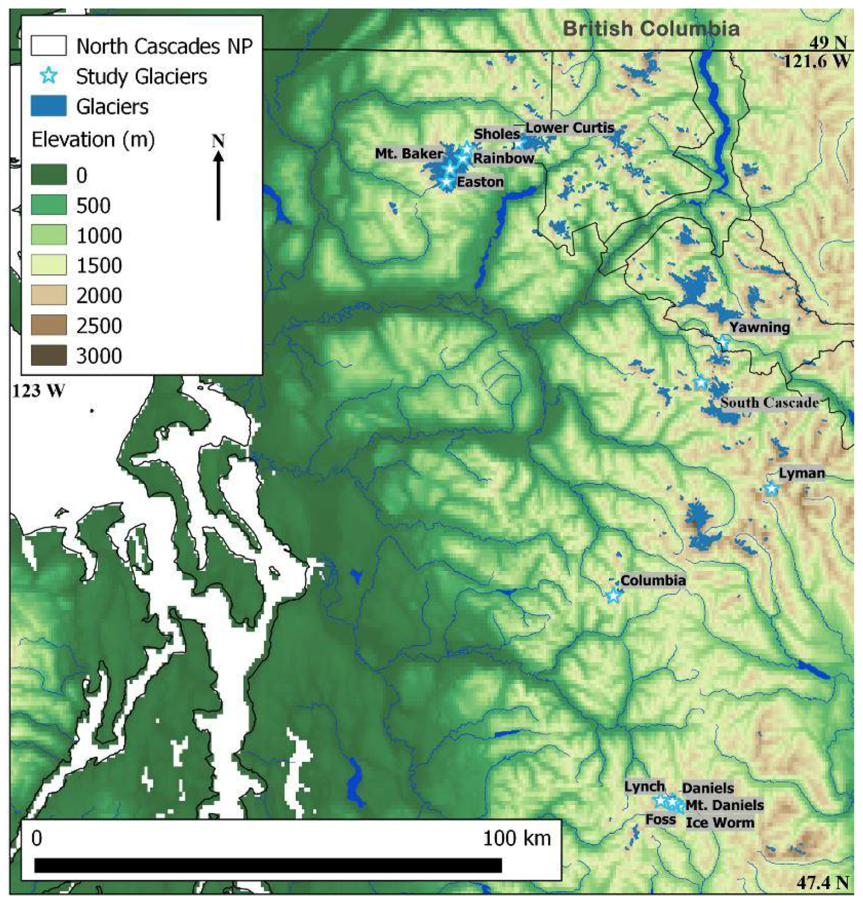
2. Methods and Data Sources

2.1. Regional Climate

The North Cascades have had a temperate maritime climate with mild year-round temperatures, abundant winter precipitation, and dry summers. The two key climate variables for the glaciers have been the accumulation-season precipitation (November–April) and ablation-season temperature (May–September) [7,9]. A warming of 0.8 °C in the mean annual temperature from 1900 to 2012 was observed from in the North Cascades [10]. The warming was accelerated to +0.20 C per decade, for the 1980–2012 period. Every season, except spring, had experienced warming, particularly during the 1980–2012 period [10].
Approximately 70% of the region’s precipitation occurred during the wet season (October–April) when the North Cascades were on the receiving end of the Pacific storm track [11,12]. From late spring to early fall, high pressure to the west kept the Pacific Northwest comparatively dry. Occasionally in the winter, warm fronts elevated temperatures and freezing levels, which resulted in rainfall at the glacier elevations. Rain on snow events had increased in frequency, this led to an increase in the ratio of the winter precipitation falling as rain versus it falling as snow. Mote [11] noted a decline in the snowpack storage efficiency in the Pacific Northwest, with the ratio between the total accumulation season precipitation and April 1 having retained snowpack SWE (snow water equivalent). Pelto [8] used the Diablo Dam and concrete weather stations for the total accumulation season precipitation for November–March—the period of accumulating the snowpack at the six SNOTEL sites, with long term records in the North Cascades—in order to determine the snowpack storage efficiency (Fish Lake, Lyman Lake, Park Creek, Rainy Pass, Stampede Pass, and Stevens Pass). For these six USDA (United States Department of Agriculture) SNOTEL stations that were utilized in this study, the mean April 1 SWE declined by 29% from 1946 to 2014. During the same period, the winter precipitation had increased slightly. The change in SWE was comparable with the change in the snowpack storage efficiency, which indicated that this was the primary cause of the reduced April 1 SWE at the North Cascade SNOTEL stations. The freezing level was a key factor in determining the snowpack storage efficiency, and an online application the North American Freezing Level Tracker was developed by Abatzoglou [12] that was utilized for the comparison of the freezing level during the winter season for Mount Baker.
The other key factor in glacier mass balance is the magnitude of ablation, which is primarily controlled by air temperature [13]. That air temperature is the key is indicated by the success of degree day factors (DDF) for assessing glacier ablation on glaciers in this region [13,14]. Nearly all of the ablation occurred during the May–September period, with the majority of the ablation having occurred from June–September. The most reliable weather station in the region was Diablo Dam, which was used for DDF derivation on the South Cascade Glacier [13]. An examination of trends in the melt season temperature at this station indicated a nearly identical pattern for May–September and June–September, which indicated that either period could be used to identify the melt season climate change. We utilized June–September, in this study, as the melt season. Six of the ten warmest melt seasons during the 1946–2014 period occurred since 2003. The long term melt season warming was 0.7 °C at Diablo Dam. The average June–September temperature from 2003 to 2014 was 0.6 °C above the mean of that for the 1946–2002 period.
The Pacific Decadal Oscillation Index (PDO) has been the leading principal component of North Pacific monthly sea surface temperature variability, poleward of 20 N [15]. During the positive PDO phase, warm weather was favored in the Pacific along the Northwest Coast and over the Pacific Northwest. During the negative phase, cool ocean water was found off the Northwest Coast and cooler temperatures were found across the Pacific Northwest [15]. In the past century, “cool” PDO regimes prevailed from 1890 to 1924 and again from 1947 to 1976, while “warm” PDO regimes dominated from 1925 to 1946 and again from 1977 to 1998 [15].
The El Niño/Southern Oscillation (ENSO) phenomenon was the most observable of the atmospheric circulation indices that led to year-to-year climate variability. ENSO positive events (El Nino) heralded abnormally warm sea surface temperatures (SST) over the eastern half of the equatorial Pacific. La Niña, was the opposite phenomenon, which was indicative of abnormally cold SST in the eastern half of the equatorial Pacific [16]. ENSO was an east–west atmospheric pressure seesaw that directly affected the tropical weather around the globe and indirectly impacted a much larger area [16]. The ENSO multivariate index (MEI-ENSO) that was used was based on the principal observed climate variables over the tropical Pacific. The index was a weighted average of the main ENSO features that were contained in the following six variables, namely: the sea-level pressure, east–west and north–south components of the surface wind, SST, surface air temperature, and total amount of cloudiness [16]. Positive MEI-ENSO values were usually accompanied by a sustained warming of the central and eastern tropical Pacific Ocean. Negative values of the MEI-ENSO index were associated with stronger Pacific trade winds and warmer sea temperatures in the Western Pacific to the north of Australia [16].
Bitz and Battisti [17] noted the importance of PDO and MEI-ENSO to glaciers in the region and observed that PDO had a greater influence during the 1960–1995 period. Josberger et al. [8] indicated that the importance of PDO had declined recently. They used three time periods, 1966–2004, 1966 to 1988, and 1989–2004, and found a significant change in the relationship between the PDO and the winter balances of the Wolverine Glacier, however less so for the South Cascade Glacier. Pelto [18] utilized the indices during the accumulation season as a first order forecast for the annual glacier mass balance, and found that the impact was the strongest when PDO and ENSO were either both positive or both negative.

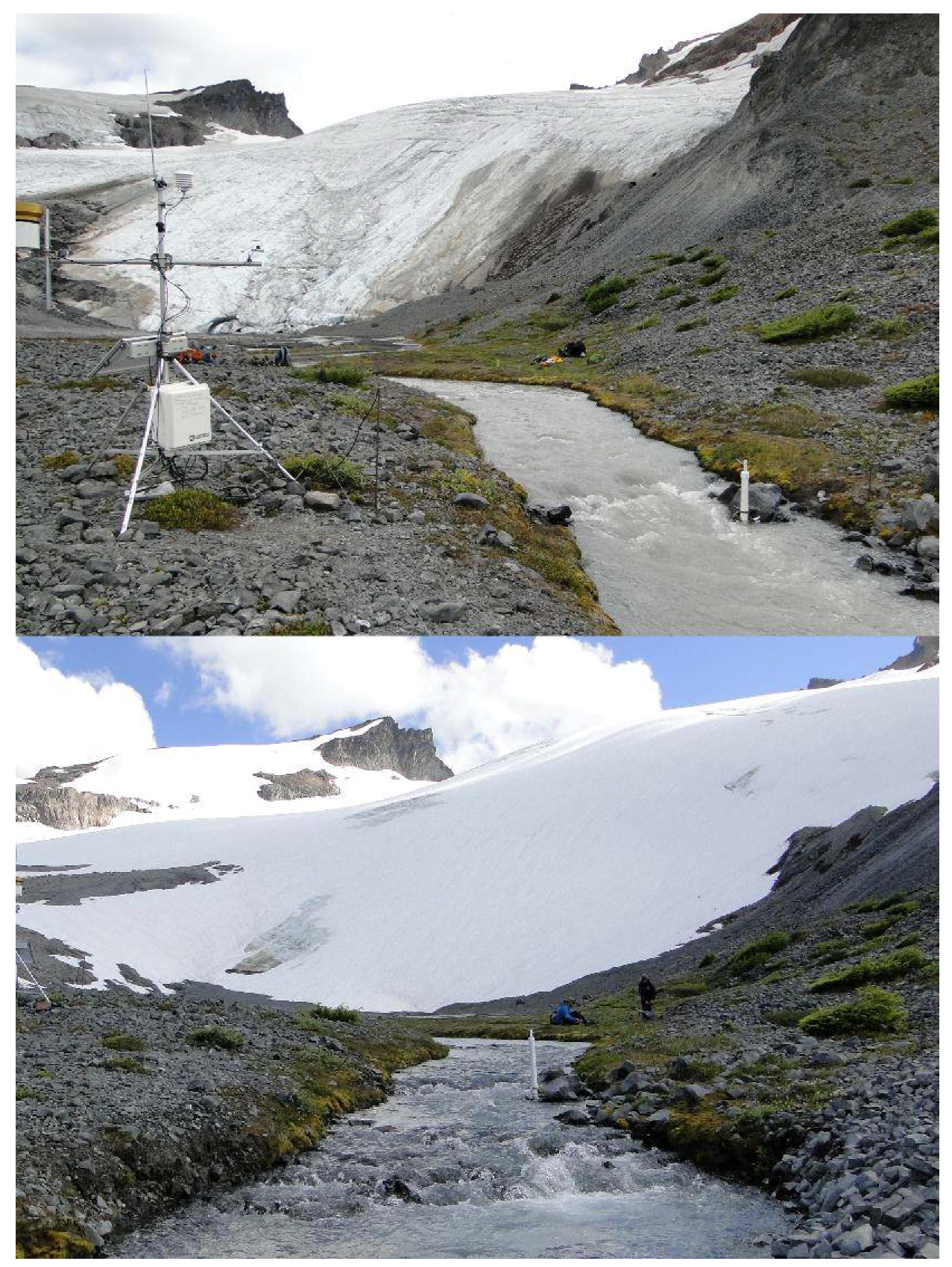
2.2. Surface Mass Balance

Annual surface mass balance (Ba) was the difference between the annual accumulation of snow/ice and the loss of snow/ice by ablation. It was typically measured on a water year basis, beginning approximately October 1 and ending September 30, in the Northern Hemisphere.
Since 1984, NCGCP monitored the Ba of 9–10 glaciers every year [18,19,20]. Seven glaciers had a 32-year record, namely, the Columbia, Daniels, Ice Worm, Lower Curtis, Lynch, Rainbow, and Yawning glaciers. The Foss Glacier had a 30 year record (1984–2013) and was discontinued because of the glacier separating into several individual bodies. Sholes and Easton Glacier had a 26-year record (1990–2015). The glaciers represented a range of geographic characteristics and spanned the North Cascade Range (Table 1 and Figure 1). The key geographic variables were the glacier orientation, elevation, accumulation sources and distance to the mountain range watershed, and climate divide. The Columbia Glacier and the Rainbow Glacier were part of the 42 reference glaciers of the WGMS data set.
NCGCP measured the conditions on a glacier near the time of minimal mass balance, at the end of the water year, using a fixed date method. NCGCP methods emphasized the surface mass balance measurements with a relatively high density of sites on each glacier (>100 sites km−2), consistent measurement methods that were applied on fixed dates and at fixed measurement locations with consistent supervision [18,19,21]. The use of a high measurement density and consistent methods generated errors, which resulted from an imperfectly representative measurement network that was largely consistent and correctable; the error range had been observed at ±0.10–0.15 ma−1 [21]. Fischer [22] examined the mass balance errors and observed that the error had declined with increased density of measurements from 0.33 ma−1, with a lower density to 0.10 ma−1 on a glacier that had a high density.
Any additional ablation that occurred after the last visit to a glacier was measured during the subsequent hydrologic year. The methods were reviewed in detail by Pelto [18,19,20,21].

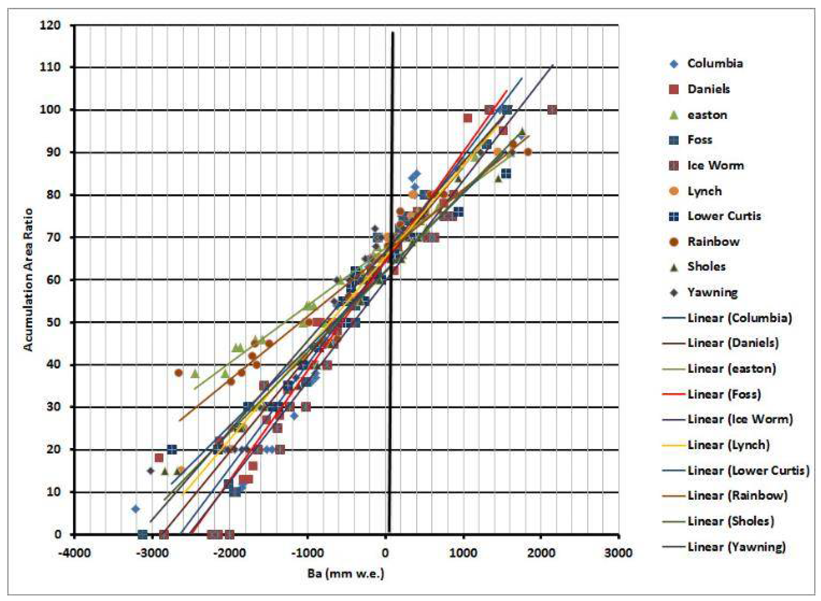
2.3. Accumulation Area Ratio
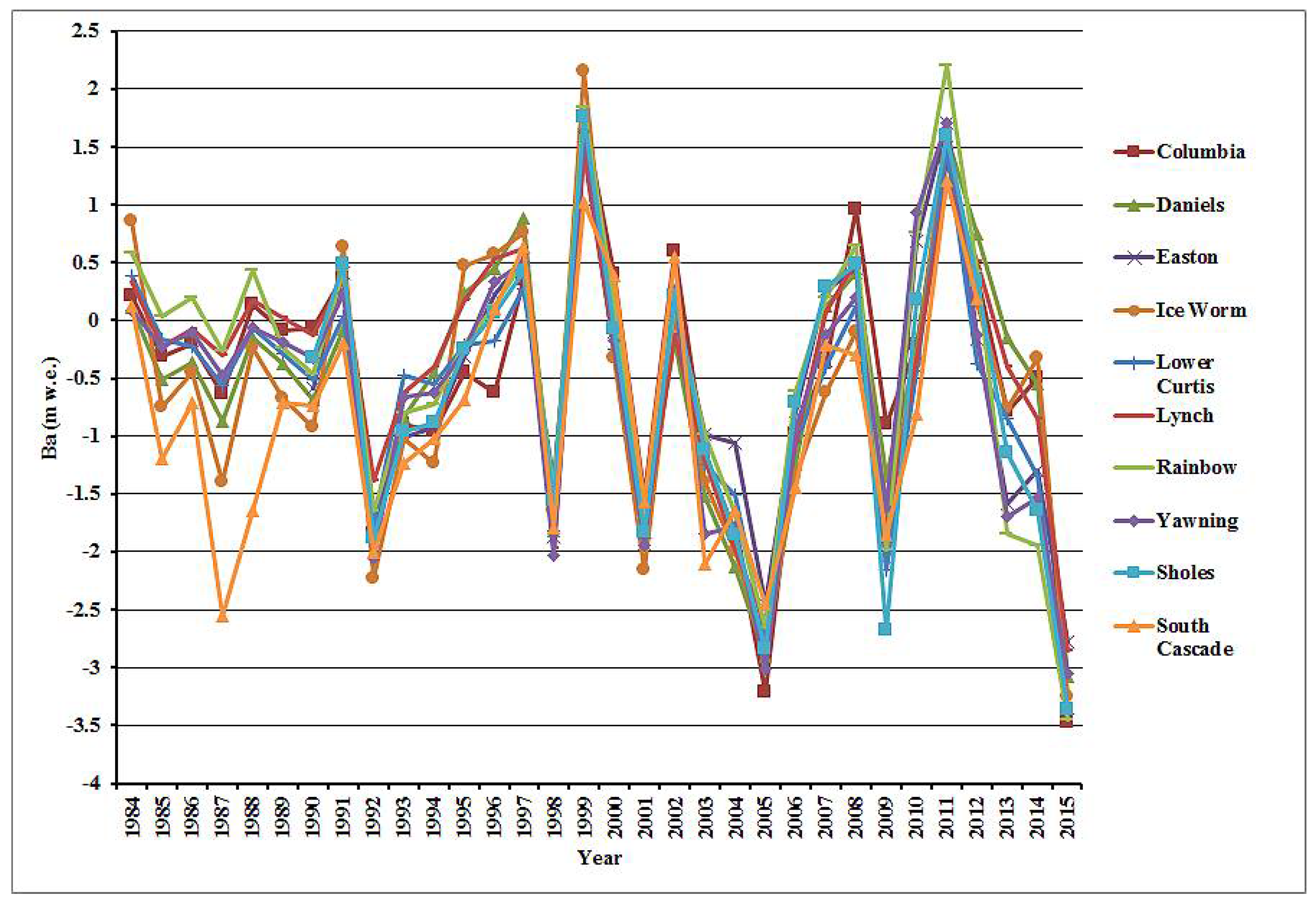
At regional scales and on specific glaciers there were two common proxies for assessing mass balance without detailed observations. They were the AAR and equilibrium line altitude (ELA), both of which could be derived from satellite imagery or photographs [23,24]. The AAR was the ratio of a glacier that was in the accumulation zone. The ELA was the elevation at which the ablation equaled accumulation, on temperate alpine glaciers this was coincidental with the transient snow line (TSL) at the end of the melt season. The ELA was not typically an easily discernible line or elevation on the North Cascades glaciers, because of the variability of the snow accumulation from the impacts of wind and avalanche redistribution. The ELA could be calculated from the balance gradient, but in such cases it was not an independent variable. The AAR was a more accurately determined parameter and a better proxy in this case [20]. The accumulation zone was a patchwork of the retained snowpack and ablation areas. Each patch of the retained snowpack was mapped and included in the AAR determination. The AAR in the North Cascades was determined from either photographs or direct surface mapping, by measuring the GPS along the TSL around each patch of the retained snowpack. The AAR–Ba method was proven to be reliable for the annual balance estimates [20,24,25]. A comparison of the annual AAR and Ba observations in WGMS [26,27] indicated correlation coefficients (Pearson’s r in all cases in the paper) ranging from 0.70 to 0.92 for fifteen glaciers, with at least 10 years of records. The World Glacier Monitoring Service (WGMS) had adopted the reporting of AAR with mass balance values [26,27] and was plotting the relationship for each glacier. A combination of the AAR observations and Ba measurements from 1984 to 2015 on the North Cascade glaciers provided an opportunity to assess the relationship for each glacier and the variability between glaciers.
The AAR0 value was the AAR for a glacier with an equilibrium mass balance [28]. Braithwaite and Muller [29] noted that the AAR0 for an alpine glacier with an equilibrium balance had averaged 0.67. The mean AAR0 that was reported for 89 temperate alpine glaciers to the WGMS was 0.57, the AAR0 value was determined from a regression of the observed Ba and AAR [26,27].

3. Results

3.1. Annual Mass Balance

The glaciers in the North Cascades exhibited consistent Ba responses to climate from year to year [19,20]. Figure 2 illustrates the closely correlated pattern of the Ba fluctuations from 1985 to 2015. In most years, all of the glaciers responded in step with each other to the variations in the winter retained snowpacks and summer temperature. There was a mean annual range between the North Cascade glaciers of 0.8 m w.e., from the maximum Ba to the minimum Ba in a given year, but the inter-annual trend was the same for each glacier (Table 2). This regional response was indicated by the high cross-correlation values of the Ba between individual glaciers, ranging from an r2 of 0.80 to 0.98, between each glacier pair, including the South Cascade Glacier that was monitored by the USGS (Table 3) [2,30]. The data for 2013–2014 had not been finalized for the South Cascade Glacier, hence, the comparison period ended in 2012 for the cross correlation. The correlation between the Ba and accumulation season precipitation was also quite similar, ranging from a low of 0.67 on the South Cascade Glacier to a high of 0.79 on the Columbia Glacier (Table 4). The correlation between the Ba and ablation season temperature was also quite similar, ranging from a low of 0.67 on the Columbia Glacier to a high of 0.80 on the Sholes Glacier (Table 4).
The mean Ba had been −0.54 m w.e.a−1 for the 1984–2015 period, on the glaciers that were monitored annually, and ranged from a maximum of −0.44 m w.e.a−1 to a minimum of −0.67 m w.e.a−1. The mean Ba, −0.54 m w.e.a−1 for the North Cascade glaciers during the 1984–2015 period, was quite similar to the WGMS global reference glacier mean Ba of 0.56 ma−1 [31]. The mean cumulative mass balance loss had been −17.2 m w.e., which was 19–20 m of glacier thickness that was lost. The mean thickness of the several glaciers that were investigated by the geophysical methods ranged from 30 to 60 m. Each glacier that was observed was larger than the mean of the North Cascade glaciers or the mean of the glaciers that were observed by NCGCP [32,33]. Thus, at least 30% of the volume of these glaciers had been lost since 1984. The observations by the USGS at the South Cascade Glacier indicated that the mean Ba from 1984 to 2012 was −0.75 m w.e.a−1 on the South Cascade Glacier, which was 0.21 m w.e.a−1 more negative than the glaciers that we monitored. The South Cascade Glacier had a much less negative mean Ba of −0.15 m w.e.a−1 from 1956 to 1975 [30].
The calculated AAR0 was based on the regression between the observed Ba and AAR on the North Cascade glaciers’ ranges, from a low of 0.60 on the Ice Worm Glacier to 0.67 on the Easton Glacier. The regression line from the plot of the AAR and Ba for the 10 North Cascade glaciers indicated a mean AAR0 of 0.64 and a correlation coefficient of 0.89 between the AAR and Ba (Figure 3).

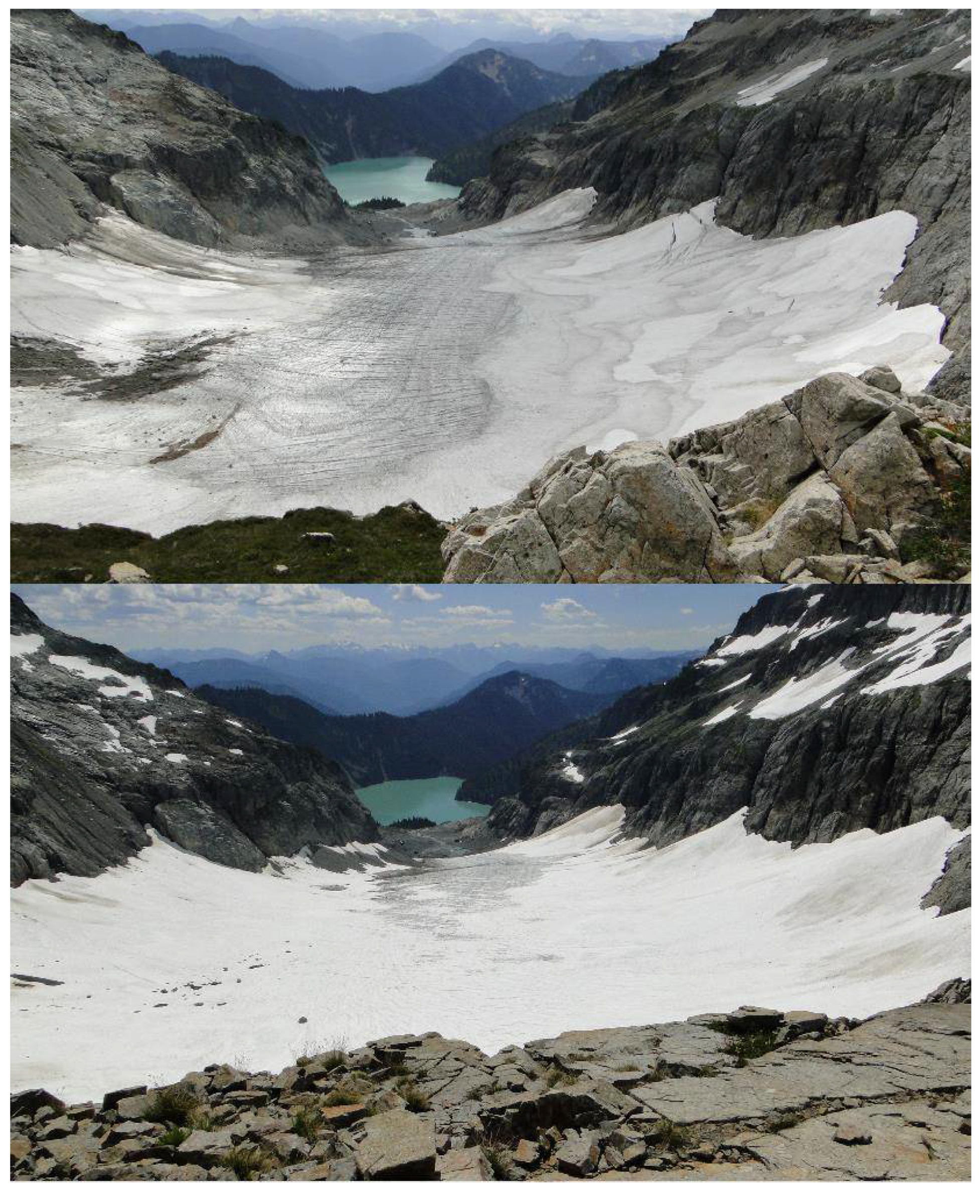
3.2. Annual Mass Balance 2015

On June 15, when the automatic weather station and discharge station were installed adjacent to the Sholes Glacier, the snowpack was similar to a typical early August snow cover. On the Sholes Glacier, the AAR fell from 0.55 on 9 July to 0.00 on 9 September (Figure 4). This was the first year since the monitoring had begun in 1984 that the mean AAR in early August was below 0.25. The result was an exposure of the older firn layers and a general decrease in albedo. In early August, the AAR was below 0.1 for all of the glaciers, except for the Easton Glacier. On the Columbia Glacier, the AAR on August 1 was the lowest observed yet at 0.12, with six weeks remaining in the melt season (Figure 5). The early exposure of glacier ice was important as the melt rate was faster, as was indicated by the greater melt factor [13,14]. In 2015, out of the nine glaciers where the Ba was examined, the AAR was 0.00 on seven of the glaciers, 0.05 on the Rainbow Glacier, and 0.26 on the Easton Glacier. This indicated the lack of a significant accumulation zone in 2015 for all of the glaciers except for the Easton Glacier. The mean AAR of 0.03 in 2015 was significantly less than the previous low of 0.16 in 2005 and the 1984–2015 mean AAR of 0.53. The mean 2015 July–August temperature, which was recorded at the automatic weather station, 100 m from the terminus of the Sholes Glacier, was 10.7 °C, with the observed ablation being 1.41 m w.e. during the month.
In 2015, the mean Ba of all of the nine glaciers in the North Cascade that were examined and reported to the WGMS was −3.19 m w.e., 2.65 m below the long term mean. The second most negative year for the Ba was −2.84 m w.e. in 2005. There was no other year that exceeded −2.0 m w.e. For each glacier, the 2015 Ba was the most negative of any year in their entire record. The South Cascade Glacier had a negative mass balance of −2.72 m w.e. in 2015, which was the most negative Ba reported since the suite of continuous mass balance measurements began in 1959 [30]. In 1958, a more negative mass balance was reported, although the winter and summer balances were not measured. This was the first full year of observations and the methods had not been standardized, hence, it was not considered part of the official USGS record [30]. In 2005, the South Cascade Glacier had a mass balance of −2.45 m w.e., the second most negative Ba since 1984.
The fact that the 10 glaciers in the North Cascades, with a Ba record of more than 25 years, had experienced their most negative mass balance in one year, indicated how unusual 2015 was. A probability function was used to determine the likelihood of the mean balance achieving a Ba of −3.19 m w.e. or less, given that the mean for the 1983–2014 period was −0.47 m w.e. and had a standard deviation of 0.97. The probability of achieving the observed 2015 Ba of −3.10 was 0.34%. The same approach was applied to individual glaciers that yielded a range of 0.1–2.5%.

3.3. Climate in 2015

The 2015 winter accumulation season featured 51% of the mean (1984–2014) winter snow accumulation at six long-term USDA SNOTEL stations in the North Cascades, namely, Fish Creek, Lyman Lake, Park Creek, Rainy Pass, Stevens Pass, and Stampede Pass. This was exceptional as it was the second lowest out of the 32 years of the mass balance observation series. The winter season was exceptional for warmth, being the warmest winter season on record in the state of Washington [34]. The freezing level in 2015 averaged 1645 m in the Mount Baker region from November–March, compared with an average of 1077 m [12]. The previous record for the mean November–March freezing level, since the record began in 1948, was 1500 m. The result was the snowpack at the six SNOTEL sites averaging 0.52 m w.e., which was 51% of the 1984–2014 average. The minimum snowpack was in 2005, with 44% of the mean snowpack, 2005 had less precipitation. The limited snowpack was not due to reduced precipitation, as the November–April precipitation at the Diablo Dam and concrete weather stations was 5–10% above the 1984–2014 mean. In 2015, the snowpack storage efficiency was the lowest, with the mean 1 April retained SWE at the six long-term SNOTEL stations being 19% of the November–March precipitation. Compared with a 1984–2014 mean of 41%, the second lowest year was 2005 at 20%. The snowline on 1 May 2015, which was the end of the typical accumulation season in the Mount Baker region, was 1400 m versus the long term average of 800 m.
In 2015, the mean May–September temperature at Diablo Dam was 2.2 °C warmer than the long term mean, and it was the second warmest to 1958 in the 1950–2015 record. For June–September, the mean temperature was 2.0 °C warmer than the long term mean, and was also second to 1958 as the warmest. The combination of the warmest melt season in over 50 years and the second lowest accumulation season snowpack in the last 30 years was a good indication that the glacier mass balance would be quite negative.
In 2015, the sea surface temperature waters that had developed in the winter of 2013/14, persisted off the coast of the Pacific Northwest, with anomalies generally exceeding 2 °C [34,35]. Such conditions were associated with a positive PDO and warm air temperatures in the Pacific Northwest [34]. From the winter of 2013/14 to 2014/15, the Northeast Pacific experienced the largest marine heatwave ever recorded [35]. In 2015, the warmest sea surface temperature paralleled the entire Pacific North American coast, which exhibited a PDO pattern [35]. A comparison of the 2015 values for the aforementioned climate parameters and the longer term means is provided in Table 5.
A comparison of annual, winter, and summer values for PDO from 1984 to 2015 indicated that 2015 ranked in the top five for each seasonal measure (Table 6). Examining the 1984–2015 period for ENSO indicated that, in 2015, the summer and annual values ranked in the top five. The 2015 hydrologic year had the most positive PDO of any year, however ENSO was not the most positive. The combined value of PDO–ENSO in 2015 ranked in the top five for both the annual and seasonal rankings, during the 1984–2015 period. The positive values for both ENSO and PDO were inversely related to the glacier mass balance and also reinforced each other [18]. This illustrated that 2015 was predisposed for a negative annual balance, based solely on the climate indices. The link between the PDO and ENSO forced the anomalous atmospheric and sea surface temperature event in 2015 [35].

4. Discussion

The examination of the Pacific Northwest glacier mass balance for the full period of research for the NCGCP and USGS benchmarked glaciers indicated that the winter balance fluctuations of the maritime glaciers dominated the Ba fluctuations [8]. Looking at the full period of record from 1984 to 2015, it was apparent that the summer balances of the benchmark glaciers had become more negative during recent years, as a result of the warmer and drier summers and, hence, the summer balance had a greater role in determining the Ba [8]. Pelto [18] developed a best fit equation for calculating the annual balance from the ablation season temperature at Diablo Dam (T), and the 1 April SWE at the six SNOTEL locations (S), which yielded results with an r value of 0.91, between the calculated and observed Ba. Using this same equation in 2015, the calculated Ba was −3.19 m w.e.
Ba = 7.0305 − 0.61496T + 2.21915s
This was the most negative calculated annual balance for the 1984–2015 period, with 2005 having had a calculated annual balance of −2.84 m w.e.
Here we used two periods, 1984–1998 and 1999–2014, with 1999 marking a transition from a period of primarily positive ENSO and PDO, to a period of negative ENSO and PDO, in order to compare the annual mass balance for each glacier to the winter PDO index (October–April) and the annual mean MEI-ENSO (October–September). During the first period, the mean correlation was −0.34 for the winter PDO and −0.59 for the annual MEI-ENSO. During the latter period, the mean correlation had increased to −0.54 for the winter PDO and −0.66 for the annual MEI-ENSO. The annual MEI-ENSO index remained a better indicator of the annual mass balance in the North Cascade Range than the winter PDO.
Overall, 2015 was exceptional in terms of the sea surface temperature in the Northeast Pacific, air temperature in the North Cascade region, 1 April snowpack, winter freezing levels, and in the positive values of PDO. ENSO was significantly positive but not exceptional. Given the similar correlation between the key climate variables of the ablation season air temperature and accumulation season precipitation and Ba, it was expected that the 2015 climate conditions would lead to record Ba losses in 2015. The mean Ba for the WGMS reference glacier network in 2015 was −1.12 m w.e., the second most negative after 2003 [31]. The mean Ba of all of the 149 WGMS reporting glaciers in 2015 was −1.04 m. Of these, 11 glaciers reported a loss of more than 3 m w.e., nine were in the state of Washington, in addition to the NCGCP glaciers—namely, the Eel Glacier in Olympic National Park and the Noisy Creek Glacier in the North Cascades National Park, as reported by the National Park Service [31]. Of the WGMS reference glacier network, the Columbia Glacier had the most negative balance of any glacier. The Ba continued to trend negatively, both globally and in the North Cascades, which indicated that, instead of approaching equilibrium as the glaciers retreated, they continued to be in disequilibrium with the current climate (Figure 4 and Figure 5) [2,36].

5. Conclusions

The impact of the warmer temperatures and reduced winter snowpack on the North Cascade glaciers has been an average annual balance of −0.54 ma−1 over the past 32 years. The net loss of −17.3 m w.e. represents a significant portion (30% of the total glacier volume), resulting in a substantial retreat and thinning. The resultant retreat is ubiquitous, rapid, and increasing. There is no evidence that the North Cascade glaciers are close to equilibrium. Their ongoing thinning indicates that all of the glaciers will continue to retreat for the foreseeable future. In cases where the thinning is substantial along the entire length of the glacier, no point of equilibrium can be achieved with present climate, and the glacier is unlikely to survive [36].
Continued glacier retreat is inevitable; 75% of the North Cascade glaciers that we observed are in disequilibrium and will melt away during this century with the current climate [36]. The loss of glacier area will lead to further declines in summer runoff in glacier fed rivers, as the glacier area available for melting in the summer declines [37,38]. This will impact salmon in streams such as the Nooksack River [39]. The correlation between the cumulative mass balance records of glaciers in various alpine glaciated regions around the globe, suggest that the global climate signal is the dominant driver of mass balance losses [2].

Acknowledgments

This work has benefitted from the support of the Nooksack Indian Tribe. This project has been sustained by over 60 field assistants, including several who spent at least three field seasons with the project, namely, Cliff Hedlund, Tom Hammond, Ben Pelto, Jill Pelto, and Bill Prater. The leadership in glacier monitoring and data reporting of the World Glacier Monitoring Service has been integral to the ongoing work of the North Cascade Glacier Climate Project field program.

Conflicts of Interest

The author declares no conflict of interest.

References

  1. Bojinski, S.; Verstraete, M.; Peterson, T.; Richter, C.; Simmons, A.; Zemp, M. The concept of Essential Climate Variables in support of climate research, applications, and policy. Bull. Am. Meteorol. Soc. 2014, 95, 1431–1443. [Google Scholar] [CrossRef]
  2. Zemp, M.; Frey, H.; Gärtner-Roer, I.; Nussbaumer, S.U.; Hoelzle, M.; Paul, F.; Haeberli, W.; Denzinger, F.; Ahlstrøm, A.P.; Anderson, B.; et al. Historically unprecedented global glacier decline in the early 21st century. J. Glaciol. 2015, 61, 745–762. [Google Scholar] [CrossRef]
  3. WGMS. Global Glacier Change Bulletin No. 1 (2012-2013); Zemp, M., Gärtner-Roer, I., Nussbaumer, S., Hüsler, F., Machguth, H., Mölg, N., Paul, F., Hoelzle, M., Eds.; ICSU(WDS)/IUGG(IACS)/UNEP/UNESCO/WMO, World Glacier Monitoring Service: Zurich, Switzerland, 2015. [Google Scholar]
  4. Post, A.; Richardson, D.; Tangborn, W.V.; Rosselot, F.L. Inventory of Glaciers in the North Cascades, Washington; US Geological Survey Prof. Paper, 705-A; U.S. Geological Survey: Reston, VI, USA, 1971.
  5. Granshaw, F.; Fountain, A. Glacier change (1958–1998) in the North Cascades National Park Complex, Washington, USA. J. Glaciol. 2006, 52, 251–256. [Google Scholar] [CrossRef]
  6. Pelto, M.S. The annual balance of North Cascade, Washington Glaciers measured and predicted using an activity index method. J. Glaciol. 1988, 34, 194–200. [Google Scholar] [CrossRef]
  7. Pelto, M.; Riedel, J. The spatial and temporal variation of mass balance on North Cascade glaciers. Hydrol. Proc. 2001, 15, 3461–3472. [Google Scholar] [CrossRef]
  8. Josberger, E.G.; Bidlake, W.R.; March, R.S.; Kennedy, B.W. Glacier mass-balance fluctuations in the Pacific Northwest and Alaska, USA. Ann. Glaciol. 2007, 46, 291–296. [Google Scholar] [CrossRef]
  9. Fountain, A.; Trabant, D.; Bruggman, M.; Ommaney, C.; Monroe, D. Glacier mass balance standards. EOS 1991, 72, 511–514. [Google Scholar] [CrossRef]
  10. Abatzoglou, J.T.; Rupp, D.E.; Mote, P.W. Seasonal Climate Variability and Change in the Pacific Northwest of the United States. J. Clim. 2014, 27, 2125–2142. [Google Scholar] [CrossRef]
  11. Mote, P.; Hamlet, A.; Salathe, E. Has spring snowpack decline in the Washington Cascades? Hydrol. Earth Syst. Sci. 2008, 12, 193–206. [Google Scholar] [CrossRef]
  12. Abatzoglou, J.T. Influence of the PNA on Declining Mountain Snowpack in the Western United States. Int. J. Climatol. 2011. [Google Scholar] [CrossRef]
  13. Rasmussen, L.A.; Conway, H.B. Using upper-air conditions to estimate South Cascade Glacier (Washington, U.S.A.) summer balance. J. Glaciol. 2003, 49, 456–462. [Google Scholar] [CrossRef]
  14. Shea, J.M.; Moore, R.D.; Stahl, K. Derivation of melt factors from glacier mass balance records in western Canada. J. Glaciol. 2009, 55, 123–130. [Google Scholar] [CrossRef]
  15. Mantua, N.J.; Hare, S.R.; Zhang, Y.; Wallace, J.M.; Francis, R.C. A Pacific interdecadal climate oscillation with impacts on salmon production. Bull. Am. Meteorol. Soc. 1997, 78, 1069–1079. [Google Scholar] [CrossRef]
  16. Wolter, K.; Timlin, M. El Niño/Southern Oscillation behaviour since 1871 as diagnosed in an extended multivariate ENSO index. Int. J. Climatol. 2011, 31, 1074–1087. [Google Scholar] [CrossRef]
  17. Bitz, C.M.; Battisti, D.S. Interannual to decadal variability in climate and the glacier mass balance in Washington, Western Canada, and Alaska. J. Clim. 1999, 12, 3181–3196. [Google Scholar] [CrossRef]
  18. Pelto, M.S. Glacier annual balance measurement, forecasting and climate correlations, North Cascades, Washington 1984–2006. Cryosphere 2008, 2, 13–21. [Google Scholar] [CrossRef]
  19. Pelto, M.S. Recent changes in glacier and alpine runoff in the North Cascades, Washington. Hydrol. Proc. 1996, 10, 1173–1180. [Google Scholar] [CrossRef]
  20. Pelto, M.S.; Brown, C. Mass balance loss of Mount Baker, Washington glaciers 1990–2010. Hydrol. Proc. 2012, 26, 2601–2607. [Google Scholar] [CrossRef]
  21. Pelto, M.S. The impact of sampling density on glacier mass balance determination. Hydrol. Proc. 2000, 14, 3215–3225. [Google Scholar] [CrossRef]
  22. Fischer, A. Comparison of direct and geodetic mass balances on a multiannual time scale. Cryosphere 2011, 5, 107–124. [Google Scholar] [CrossRef]
  23. Østrem, G. The transient snowline and glacier mass balance in southern British Columbia and Alberta, Canada. Geogr. Ann. A 1973, 55, 93–106. [Google Scholar] [CrossRef]
  24. Racoviteanu, A.; Williams, M.; Barry, R. Optical remote sensing of glacier characteristics: A review with focus on the Himalaya. Sensors 2008, 8, 3355–3383. [Google Scholar] [CrossRef] [PubMed]
  25. Hock, R.; Koostra, D.; Reijmeer, C. Deriving glacier mass balance from accumulation area ratio on Storglaciären, Sweden. In Glacier Mass Balance Changes and Meltwater Discharge; IAHS: Wallingford, UK, 2007; Volume 318, pp. 163–170. [Google Scholar]
  26. WGMS. Glacier Mass Balance Bulletin No. 9 (2004–2005); Haeberli, W., Hoelzle, M., Zemp, M., Eds.; ICSU(FAGS)/IUGG(IACS)/UNEP/UNESCO/WMO, World Glacier Monitoring Service, University of Zurich: Zurich, Switzerland, 2007. [Google Scholar]
  27. WGMS. Glacier Mass Balance Bulletin No. 10 (2006–2007); Haeberli, W., Gartner-Roer, I., Hoelzle, M., Paul, F., Zemp, M., Eds.; CSU(FAGS)/IUGG(IACS)/UNEP/UNESCO/WMO, World Glacier Monitoring Service, University of Zurich: Zurich, Switzerland, 2009. [Google Scholar]
  28. Meier, M.F.; Post, A. Recent variations in mass net budgets of glaciers in western North America. IAHS 1962, 58, 63–77. [Google Scholar]
  29. Braithwaite, R.J.; Müller, F. On the Parameterization of Glacier Equilibrium Line; IAHS: Wallingford, UK, 1980; Volume 126, pp. 263–271. [Google Scholar]
  30. Bidlake, W.R.; Josberger, E.G.; Savoca, M.E. Modelled and Measured Glacier Change and Related Glaciological, Hydrological, and Meteorological Conditions at South Cascade Glacier, Washington, Balance and Water Years 2006 and 2007; U.S. Geological Survey Scientific Investigations Report 2010-5143; U.S. Geological Survey: Reston, VI, USA, 2010.
  31. WGMS. Global Glacier Change Bulletin No. 2 (2014-2015); Zemp, M., Nussbaumer, S.U., Gärtner-Roer, I., Huber, J., Machguth, H., Paul, F., Hoelzle, M., Eds.; ICSU(WDS)/IUGG(IACS)/UNEP/UNESCO/WMO, World Glacier Monitoring Service: Zurich, Switzerland, 2017; p. 244. [Google Scholar]
  32. Pelto, M.S.; Hedlund, C. The terminus behavior and response time of North Cascade glaciers. J. Glaciol. 2001, 47, 497–506. [Google Scholar] [CrossRef]
  33. Finn, C.A.; Deszcz-Pan, M.; Bedrosian, P.A. Helicopter electromagnetic data map ice thickness at Mount Adams and Mount Baker, Washington, USA. J. Glaciol. 2012, 58, 1133–1143. [Google Scholar] [CrossRef]
  34. Bond, N.; Cronin, M.; Freeland, H.; Mantua, N. Causes and impacts of the 2014 warm anomaly in the NE Pacific. Geophys. Res. Lett. 2015, 42, 3414–3420. [Google Scholar] [CrossRef]
  35. Di Lorenzo, E.; Mantua, N. Multi-year persistence of the 2014/15 North Pacific marine heatwave. Nat. Clim. Chang. 2016. [Google Scholar] [CrossRef]
  36. Pelto, M.S. Forecasting Temperate Alpine Glacier Survival from Accumulation Zone Observations. Cryosphere 2010, 3, 323–350. [Google Scholar] [CrossRef]
  37. Stahl, K.; Moore, D. Influence of watershed glacier coverage on summer streamflow in British Columbia, Canada. Water Resour. Res. 2006, 42, W06201. [Google Scholar] [CrossRef]
  38. Grah, O.; Beaulieu, J. The effect of climate change on glacier ablation and baseflow support in the Nooksack River basin and implications on Pacific salmonid species protection and recovery. Clim. Chang. 2013. [Google Scholar] [CrossRef]
  39. Pelto, M.S. Climate Driven Retreat of Mount Baker Glaciers and Changing Water Resouorces; Springer Briefs in Climate Studies; Springer: Berlin/Heidelberg, Germany, 2015; ISBN 978-3-319-22605-7. [Google Scholar]
Figure 1. Base map of the North Cascades, indicating glaciers observed in detail by the North Cascade Glacier Climate Project (NCGCP).
Water 10 00543 g001
Figure 2. Mean annual balance of the North Cascade glaciers, indicating the similar annual response to climate forcing. Ba—annual mass balance.
Water 10 00543 g002
Figure 3. Relationship between annual balance and accumulation are a ration on the North Cascade glaciers.
Water 10 00543 g003
Figure 4. Limited retained snowcover on 8 August 2015 on the Sholes Glacier (above), with the discharge and weather station in foreground. On 8 August 2016, the Sholes Glacier snowcover is typical for early August.
Water 10 00543 g004
Figure 5. The Columbia Glacier from above the accumulation zone on 1 August 2015, with seven weeks left in the ablation season, little 2015 accumulation is retained. The Columbia Glacier from above the accumulation zone on 11 August 2016, with six weeks left in the accumulation season.
Water 10 00543 g005
Table 1. The geographic characteristics of the nine glaciers where the annual balance has been monitored annually (Figure 1). Accumulation sources are listed in order of significance: wind drifting = WD, avalanche accumulation = AV, direct snowfall = DS.
GlacierAspectArea (km2)AccumulationTo DivideElevation (m)
ColumbiaSSE0.9AV, DS, WD15 km west1750–1450
DanielsE0.4DS, WD1 km east2230–1970
EastonSSE2.9DS, WD75 km west2900–1700
FossNE0.4DS, WDAt divide2100–1840
Ice WormSE0.1DS, AV, WD1 km east2100–1900
Lower CurtisS0.8AV, DS, WD55 km west1850–1460
LynchN0.7DS, WDAt divide2200–1950
RainbowENE1.6DS, WD, AV70 km west 2040–1310
SholesN0.9DS, WD70 km west2070–1630
YawningN0.2DS, WDAt divide 2100–1880
Table 2. Annual mass balance of the North Cascades glaciers from 1984–2015. The South Cascade Glacier was observed by the USGS, all of the others were observed by the North Cascade Glacier Climate Project (NCGCP).
YearColumbiaDanielsEastonFossIce WormLower CurtisLynchRainbowYawningSholesSouth Cascade
19840.210.11 0.510.860.390.330.580.09 0.12
1985−0.31−0.51 −0.69−0.75−0.16−0.220.04−0.23 −1.2
1986−0.2−0.36 0.12−0.45−0.22−0.070.2−0.1 −0.71
1987−0.63−0.87 −0.38−1.39−0.56−0.3−0.26−0.47 −2.56
19880.14−0.15 0.23−0.24−0.060.170.43−0.06 −1.64
1989−0.09−0.37 0.09−0.67−0.290.03−0.24−0.19 −0.71
1990−0.06−0.68−0.58−0.27−0.92−0.51−0.12−0.46−0.32−0.32−0.73
19910.38−0.070.410.30.630.040.360.440.230.48−0.2
1992−1.85−1.7−1.67−1.92−2.23−1.76−1.38−1.65−2.06−1.88−2.01
1993−0.9−0.83−1.01−0.73−1.02−0.48−0.62−0.8−0.66−0.96−1.23
1994−0.96−0.45−0.92−0.68−1.23−0.55−0.4−0.72−0.62−0.88−1.02
1995−0.450.24−0.310.310.47−0.210.18−0.2−0.26−0.25−0.69
1996−0.620.450.220.340.57−0.180.530.120.340.060.1
19970.350.880.530.50.760.270.620.510.50.420.63
1998−1.46−1.82−1.87−1.95−1.64−1.38−1.97−1.49−2.03−1.56−1.8
19991.751.521.611.562.151.551.451.841.631.761.02
20000.4−0.25−0.1−0.1−0.33−0.25−0.240.15−0.18−0.080.38
2001−1.52−1.75−1.93−1.92−2.15−1.88−1.82−1.71−1.94−1.83−1.57
20020.6−0.180.180.10.050.13−0.130.120.260.210.55
2003−1.17−1.52−0.98−1.35−1.4−1.25−1.2−0.98−1.85−1.12−2.1
2004−1.83−2.13−1.06−1.94−2−1.51−1.98−1.67−1.78−1.86−1.65
2005−3.21−2.9−2.45−3.12−2.85−2.75−2.62−2.65−3.02−2.84−2.45
2006−0.98−1.25−0.79−1.02−1.35−1.06−1.05−0.61−0.93−0.71−1.45
2007−0.370.120.26−0.38−0.62−0.40.070.2−0.130.29−0.21
20080.960.410.450.18−0.10.120.510.650.20.48−0.3
2009−0.9−1.35−2.06−2.02−1.56−2.15−1.82−1.98−1.62−2.68−1.86
2010−0.21−0.260.68−0.11−0.38−0.44−0.340.760.940.17−0.81
20111.471.061.151.31.340.940.981.641.221.451.21
20120.380.75−0.160.250.15−0.380.510.420.34−0.120.19
2013−0.78−0.15−1.58−0.5−0.76−0.85−0.4−1.85−1.15−1.7
2014−0.5−0.8−1.3 −0.62−1.35−1.12−1.94−1.53−1.65
2015−3.48−3.08−2.78 −3.25−3.40−2.85−3.45−3.05−3.36−2.72
Mean−0.40−0.48−0.53−0.44−0.57−0.55−0.39−0.36−0.50−0.60−0.77
Table 3. Cross-correlation of annual balance on the North Cascade glaciers from 1984–2014, except for the Sholes Glacier and the Easton Glacier from 1990 to 2014. The South Cascade Glacier has been observed by the USGS from 1985 to 2012, all of the other glaciers data is from the NCGCP.
GlacierDanielsEastonFossIce WormLower CurtisLynchRainbowYawningSholesSouth Cascade
Columbia0.900.880.920.890.920.900.910.920.900.83
Daniels1.000.870.950.940.910.970.880.930.880.86
Easton0.871.000.920.900.930.900.980.950.980.89
Foss0.950.921.000.940.970.980.930.950.940.82
Ice Worm0.940.900.941.000.930.920.890.910.910.87
Lower Curtis0.910.930.970.971.000.950.940.940.960.81
Lynch0.970.900.980.980.951.000.910.940.930.80
Rainbow0.880.980.930.930.940.911.000.960.980.80
Yawning0.930.950.950.950.940.940.961.000.940.82
Sholes0.880.980.940.910.960.930.980.941.000.91
South Cascade0.860.890.820.870.810.800.800.820.911.00
Table 4. Cross-correlation of annual balance on the North Cascade glaciers from 1984 to 2014, except for the Sholes Glacier (SHS) and the Easton Glacier (EAS) from 1990 to 2014. The South Cascade Glacier (SC) has been observed by the USGS from 1985 to 2012. Accumulation season precipitation is the mean April 1 SWE from six SNOTEL stations (Fish Lake, Lyman Lake, Park Creek, Rainy Pass, Stevens Pass, and Stampede Pass. Ablation season temperature is from Diablo Dam. COL—Columbia; DAN—Daniels; FOS—Foss; IW—Ice Worm; LC—Lower Curtis; LY—Lynch; RBW—Rainbow; YWG—Yawning.
Climate VariableCOLDANEASFOSIW LCLYRBWYWGSHSSC
Corr-SWE0.790.770.740.720.780.750.760.700.710.770.67
Corr AT−0.68−0.67−0.79−0.64−0.70−0.74−0.71−0.79−0.74−0.80−0.72
Table 5. Comparison of 2015 climate conditions to average conditions PPT = precipitation SWE = snow water equivalent.
Time PeriodWinter PPT (November–March)April 1 SWESWE/PPTAblation Season Temp. (May–September)Summer Temp. (June–September)Freezing Level (November–March)
20152.620.520.1918.1418.831644
1950–20152.51.140.4615.9416.861077
1984–20152.511.050.4116.1617.11144
Table 6. Ranking of the mean Pacific Decadal Oscillation Index (PDO), El Niño/Southern Oscillation (ENSO), and PDO–ENSO for 1984–2015, for summer (S), winter (W), and annual (A).
RankingPDO-WPDO-SPDO-AENSO-WENSO-SENSO-ACOMB-WCOMB-SCOMB-A
1201519972015199819871998199819971987
2198719871993198719971987198719932015
3200320152003199220151992201519871998
4199819921987199519922015200320151993
5198819951994198819931993198819921992

