Glacier Changes between 1976 and 2015 in the Source Area of the Ayeyarwady (Irrawaddy) River, Myanmar


Abstract
1. Introduction
2. Materials and Methods
2.1. Remote Sensing Data and Glacier Delineation
2.2. Glacier Terminus Position and Glacier Length
2.3. Glacier Change Analyses
2.4. Conversion into Water Equivalent
3. Results
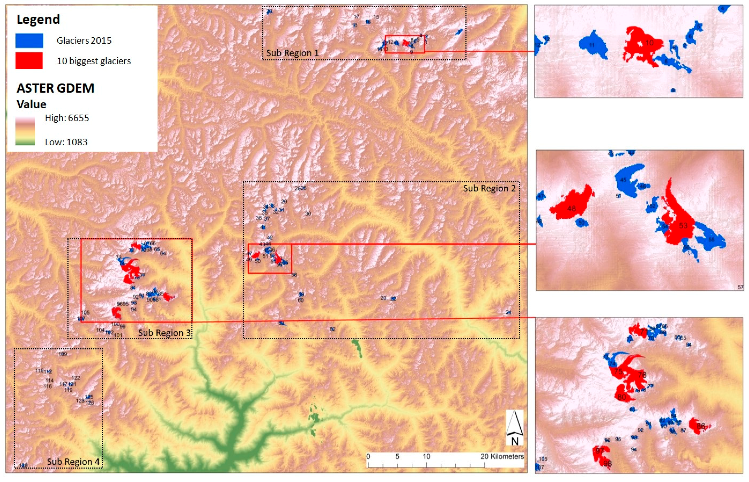
3.1. Current Situation of the Glaciers
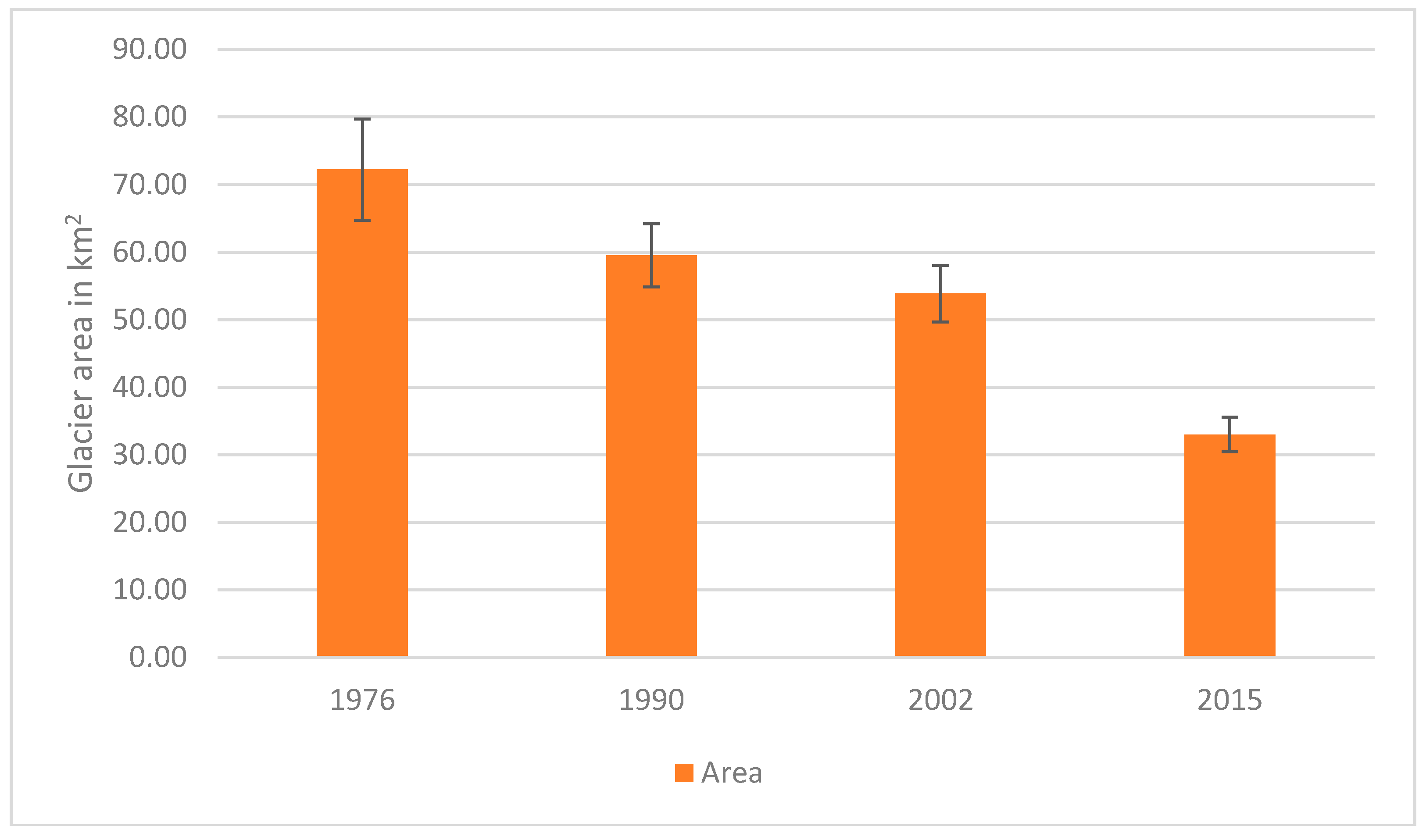
3.2. Glacier Changes between 1976 and 2015
3.2.1. Changes in Glacier Area
3.2.2. Changes in Terminus Position and Length
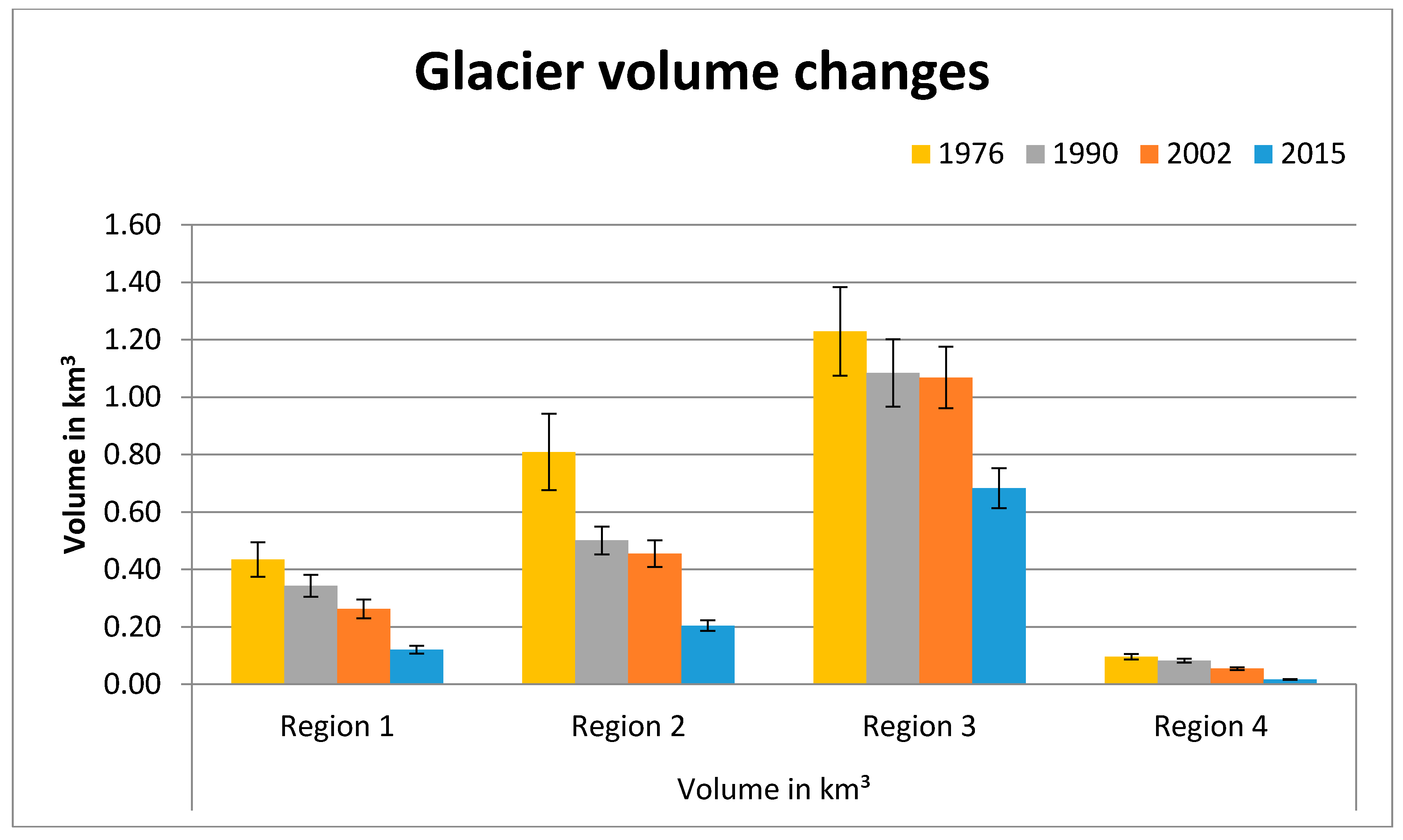
3.2.3. Changes in Volume and Mass
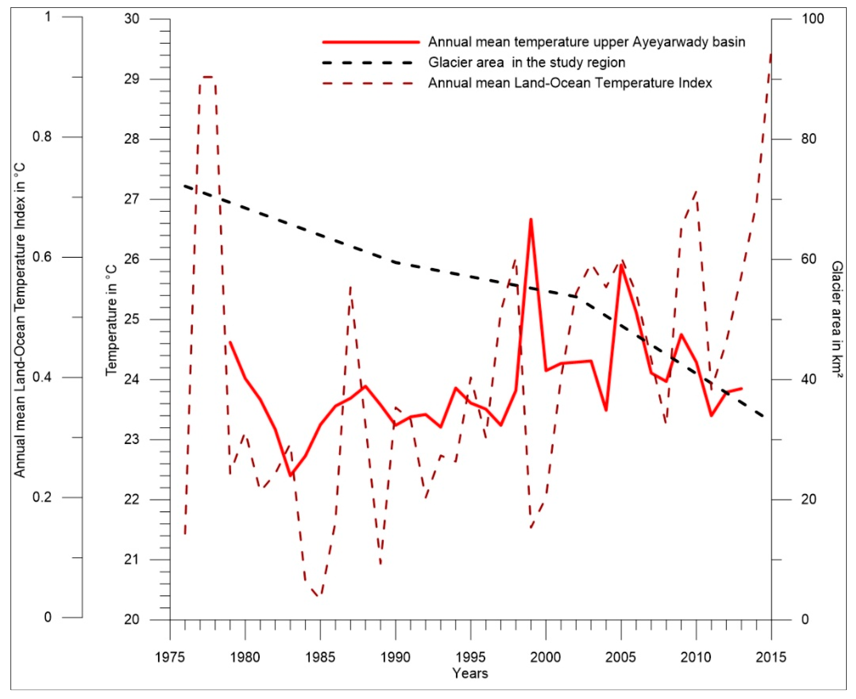
4. Discussion
4.1. Possible Future Development
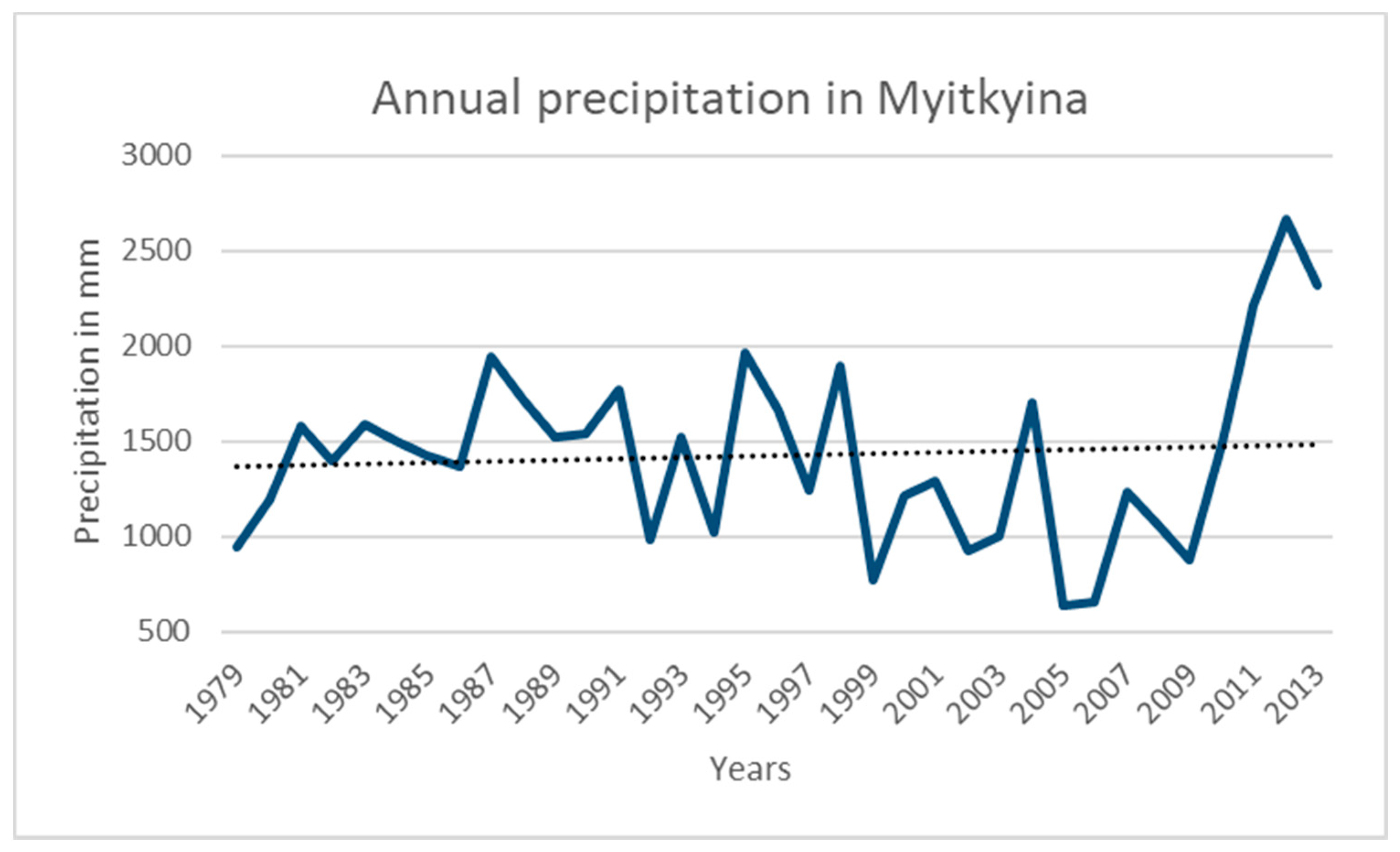
4.2. Implications for Downstream Areas
5. Conclusions
Author Contributions
Funding
Acknowledgments
Conflicts of Interest
References
- Barnett, T.P.; Adam, J.C.; Lettenmaier, D.P. Potential impacts of a warming climate on water availability in snow-dominated regions. Nature 2005, 438, 303–309. [Google Scholar] [CrossRef] [PubMed]
- IPCC. Climate Change 2013: The Physical Basis; Contribution of Working Group I to the Fifth Assessment Report of the Intergovernmental Panel on Climate Change; IPCC: Cambridge, UK; New York, NY, USA, 2013. [Google Scholar]
- Bajracharya, S.R.; Maharjan, S.B.; Shrestha, F.; Guo, W.; Liu, S.; Immerzeel, W.; Shrestha, B. The glaciers of the Hindu Kush Himalayas: Current status and observed changes from the 1980s to 2010. Int. J. Water Resour. Dev. 2015, 31, 161–173. [Google Scholar] [CrossRef]
- Karpilo, R.D. Glacier monitoring techniques. In Geological Monitoring; Young, R., Norby, L., Eds.; Geological Society of America: Boulder, CO, USA, 2009; pp. 141–162. [Google Scholar] [CrossRef]
- Sorg, A.; Bolch, T.; Stoffel, M.; Solomina, O.; Beniston, M. Climate change impacts on glaciers and runoff in Tien Shan (Central Asia). Nat. Clim. Chang. 2012, 2, 725–731. [Google Scholar] [CrossRef]
- Thayyen, R.J.; Gergan, J.T. Role of glaciers in watershed hydrology: A preliminary study of a “Himalayan catchment”. Cryosphere 2010, 4, 115–128. [Google Scholar] [CrossRef]
- Lutz, A.F.; Immerzeel, W.W.; Shrestha, A.B.; Bierkens, M.F.P. Consistent increase in High Asia’s runoff due to increasing glacier melt and precipitation. Nat. Clim. Chang. 2014, 4, 587–592. [Google Scholar] [CrossRef]
- Department of Population, Ministry of Immigration and Population. The 2014 Myanmar Population and Housing Census, Kachin State, Census Report Volume 3-A. 2015. Available online: https://myanmar.unfpa.org/en/publications/union-report-volume-3a-kachin-state-report (accessed on 27 November 2018).
- Taft, L.; Evers, M. A review of current and possible future human–water dynamics in Myanmar’s river basins. Hydrol. Earth Syst. Sci. 2016, 20, 4913–4928. [Google Scholar] [CrossRef]
- Furuichi, T.; Win, Z.; Wasson, R.J. Discharge and suspended sediment transport in the Ayeyarwady River, Myanmar: Centennial and decadal changes. Hydrol. Process. 2009, 23, 1631–1641. [Google Scholar] [CrossRef]
- Bajracharya, S.R.; Shrestha, B. (Eds.) The Status of Glaciers in the Hindu Kush-Himalayan Region; ICIMOD: Kathmandu, Nepal, 2011; Available online: https://www.cabdirect.org/cabdirect/FullTextPDF/2012/20123056405.pdf (accessed on 17 January 2018).
- U.S. Geological Survey USGS. EarthExplorer. 2017. Available online: https://earthexplorer.usgs.gov/ (accessed on 26 January 2017).
- Mukul, M.; Srivastava, V.; Jade, S.; Mukul, M. Uncertainties in the Shuttle Radar Topography Mission (SRTM) Heights: Insights from the Indian Himalaya and Peninsula. Nat. Sci. Rep. 2017, 7, 41672. [Google Scholar] [CrossRef]
- Berthier, E.; Arnaud, Y.; Vincent, C.; Rémy, F. Biases of SRTM in high-mountain areas: Implications for the monitoring of glacier volume changes. Geophys. Res. Lett. 2006, 33, L08502. [Google Scholar] [CrossRef]
- Paul, F.; Kääb, A.; Maisch, M.; Kellenberger, T.; Haeberli, W. The new remote-sensing-derived Swiss glacier inventory: I. Methods. Ann. Glaciol. 2002, 34, 355–361. [Google Scholar] [CrossRef]
- Bolch, T. Climate change and glacier retreat in northern Tien Shan (Kazakhstan/Kyrgyzstan) using remote sensing data. Glob. Planet. Chang. 2007, 56, 1–12. [Google Scholar] [CrossRef]
- Grinsted, A. An estimate of global glacier volume. Cryosphere 2013, 7, 141–151. [Google Scholar] [CrossRef]
- Bahr, D.B.; Meier, M.F.; Peckham, S.D. The physical basis of glacier volume-area scaling. J. Geophys. Res. 1997, 102, 20355–20362. [Google Scholar] [CrossRef]
- Bahr, D.B.; Pfeffer, W.T.; Kaser, G. A review of volume-area scaling of glaciers: Volume-area scaling. Rev. Geophys. 2015, 53, 95–140. [Google Scholar] [CrossRef] [PubMed]
- Laumann, T.; Nesje, A. Volume-area scaling parameterization of Norwegian ice caps: A comparison of different approaches. Holocene 2016, 27, 164–171. [Google Scholar] [CrossRef]
- Racoviteanu, A.E.; Williams, M.W.; Barry, R.G. Optical remote sensing of glacier characteristics: A review with focus on the Himalaya. Sensors 2008, 8, 3355–3383. [Google Scholar] [CrossRef] [PubMed]
- Raup, B.H.; Andreassen, L.M.; Bolch, T.; Bevan, S. Remote sensing of glaciers. In Remote Sensing of the Cryosphere; Tedesco, M., Ed.; John Wiley & Sons, Ltd.: Chichester, UK, 2015. [Google Scholar]
- Dyck, S.; Peschke, G. Grundlagen der Hydrologie; Verlag für Bauwesen: Berlin, Germany, 1995. [Google Scholar]
- NRCS Natural Conservation Service Oregon. What Is Snow Water Equivalent. Available online: http://nrcs.usda.gov/wps/portal/nrcs/detail/or/snow/?cid=nrcs142p2046155 (accessed on 9 January 2017).
- Bookhagen, B.; Burbank, D.W. Toward a complete Himalayan hydrological budget: Spatiotemporal distribution of snowmelt and rainfall and their impact on river discharge. J. Geophys. Res. 2010, 115, FO3019. [Google Scholar] [CrossRef]
- Panday, P.K.; Williams, C.A.; Frey, K.E.; Brown, M.E. Application and evaluation of snowmelt runoff model in the Tamor River basin, Eastern Himalaya using a Markov Chain Monte Carlo (MCMC) data assimilation approach. Hydrol. Process. 2013, 28. [Google Scholar] [CrossRef]
- Ren, J.; Jing, Z.; Pu, J.; Qin, X. Glacier variations and climate change in the central Himalaya over the past few decades. Ann. Glaciol. 2006, 43, 218–222. [Google Scholar] [CrossRef]
- Jianchu, X.; Shrestha, A.; Eriksson, M. Climate change and its impacts on glaciers and water resource management in the Himalayan Region. In Assessment of Snow, Glaciers and Water Resources in Asia; International Hydrological Programme of UNESCO and Hydrology and Water Resources Programme of WMO: Koblenz, Germany, 2009; pp. 44–54. [Google Scholar]
- UNEP United Nations Environmental Program. The Glaciers of the Hindu-Kush Himalayan Region.: A Summary of the Science Regarding Glacier Melt/Retreat in the Himalayan, Hindu Kush, Karakoram, Pamir, and Tien Shan Mountain Ranges; Technical Paper; UNEP: Kathmandu, Nepal, 2010. [Google Scholar]
- Yao, T.; Thompson, L.; Yang, W.; Yu, W.; Gao, Y.; Guo, X.; Yang, X.; Duan, K.; Zhao, H.; Xu, B.; et al. Different glacier status with atmospheric circulations in Tibetan Plateau and surroundings. Nat. Clim. Chang. 2012, 2, 663–667. [Google Scholar] [CrossRef]
- NCEP National Centers for Environmental Prediction. Global Weather Data for SWAT. 2018. Available online: https://globalweather.tamu.edu/#pubs Access on (accessed on 16 August 2018).
- NASA. Annual mean Land-Ocean Temperature Index in Degrees Celsius. 2018. Available online: https://data.giss.nasa.gov/gistemp/graphs/graph_data/Hemispheric_Temperature_Change/graph.txt (accessed on 16 August 2018).
- Pan, B.T.; Zhang, G.L.; Wang, J.; Cao, B.; Geng, H.P.; Wang, J.; Zhang, C.; Ji, Y.P. Glacier changes from 1966-2009 in the Gongga Mountains, on the south-eastern margin of the Qinghai-Tibetan Plateau and their climatic forcing. Cryosphere 2012, 6, 1087–1101. [Google Scholar] [CrossRef]
- Liu, Q.; Liu, S.Y.; Zhang, Y.; Wang, X.; Zhang, Y.S.; Guo, W.Q.; Xu, J.L. Recent shrinkage and hydrological response of Hailuogou glacier, a monsoon temperate glacier on the eastern slope of Mount Gongga, China. J. Glaciol. 2010, 56, 215–224. [Google Scholar] [CrossRef]
- Bolch, T.; Kulkarni, A.; Kääb, A.; Huggel, C.; Paul, F.; Cogley, J.G.; Frey, H.; Kargel, J.S.; Fujita, K.; Scheel, M.; et al. The state and fate of Himalayan glaciers. Science 2012, 336, 310–314. [Google Scholar] [CrossRef] [PubMed]
- Nuimura, T.; Sakai, A.; Taniguchi, K.; Nagai, H.; Lamsal, D.; Tsutaki, S.; Kozawa, A.; Hoshina, Y.; Takenaka, S.; Omiya, S.; et al. The GAMDAM glacier inventory: a quality controlled inventory of Asian glaciers. Cryosphere 2015, 9, 849–864. [Google Scholar] [CrossRef]
- Kulkarni, A.V.; Bahuguna, I.M.; Rathore, B.P.; Singh, S.K.; Randhawa, S.S.; Sood, R.K.; Dhar, S. Glacial retreat in Himalaya using Indian Remote Sensing satellite data. Curr. Sci. 2007, 92, 69–74. [Google Scholar]
- Kaldybayev, A.; Chen, Y.; Issanova, G.; Wang, H.; Mahmudova, L. Runoff response to the glacier shrinkage in the Karatal river basin, Kazakhstan. Arab. J. Geosci. 2016, 9, 208. [Google Scholar] [CrossRef]
- Bhambri, R.; Bolch, T.; Chaujar, R.K.; Kulshreshtha, S.C. Glacier changes in the Garhwal Himalaya, India, from 1968 to 2006 based on remote sensing. J. Glaciol. 2011, 57, 543–556. [Google Scholar] [CrossRef]
- Su, Z.; Shi, Y. Response of monsoonal temperate glaciers to global warming since the Little Ice Age. Q. Int. 2002, 97, 123–131. [Google Scholar] [CrossRef]
- Frey, H.; Machguth, H.; Huss, M.; Huggel, C.; Bajrachyrya, S.; Bolch, T.; Kulkarni, A.; Linsbauer, A.; Salzmann, N.; Stoffel, M. Estimating the volume of glaciers in the Himalayan-Karakoram region using different methods. Cryosphere 2014, 8, 2313–2333. [Google Scholar] [CrossRef]
- Kaser, G.; Großhauser, M.; Marzeion, B. Contribution potential of glaciers to water availability in different climate regimes. Proc. Natl. Acad. Sci. USA 2010, 107, 20223–20227. [Google Scholar] [CrossRef]


| Year | Satellite | ID | Recording Date | Cloud Cover (%) | Purpose |
|---|---|---|---|---|---|
| 1976 | LS MSS | LM2143040_1976293XXX01 | 19.10.1976 | 6 | Analysis |
| 1976 | LS MSS | LM2143040_1976311TGS02 | 06.11.1976 | 5 | Correction |
| 1976 | LS MSS | LM2143041_1976293XXX01 | 19.10.1976 | 12 | Analysis |
| 1990 | L5 TM | LT5133040_1990331BJC00 | 27.11.1990 | 23 | Analysis |
| 1990 | L5 TM | LT5133041_1990331BJC00 | 27.11.1990 | 5 | Analysis |
| 2002 | L7 ETM+ | LE7133040_2002004BKT00 | 04.01.2002 | 24 | Analysis |
| 2002 | L7 ETM+ | LE7133041_2002004BKT00 | 04.01.2002 | 9 | Analysis |
| 2015 | L8 OLI/TIRS | LC8133040_2015272LGN00 | 29.09.2015 | 4 | Analysis |
| 2015 | L8 OLI/TIRS | LC8133041_2015272LGN00 | 29.09.2015 | 17 | Analysis |
| Year | Satellite + Path/Row | TM3/TM5 Threshold |
|---|---|---|
| 1976 | MSS 133/40 | - |
| 1976 | MSS 133/41 | - |
| 1990 | TM 133/40 | 3 |
| 1990 | TM 133/41 | 3.2 |
| 2002 | ETM+ 133/40 | 3.4 |
| 2002 | ETM+ 133/41 | 3.2 |
| 2015 | OLI/TIRS 133/40 | 1.3 |
| 2015 | OLI/TIRS 133/41 | 1.1 |
| Sub-Region | No. of Glaciers | Area in km2 | Mean Area in km2 |
|---|---|---|---|
| 1 | 20 | 4.75 ± 0.35 | 0.24 ± 0.00 |
| 2 | 43 | 7.99 ± 0.54 | 0.18 ± 0.00 |
| 3 | 44 | 19.08 ± 1.54 | 0.42 ± 0.00 |
| 4 | 22 | 1.19 ± 0.1 | 0.06 ± 0.00 |
| Sub-Region | Volume in km3 | Mass in Gt |
|---|---|---|
| 1 | 0.12 ± 0.00 | 0.11 ± 0.00 |
| 2 | 0.20 ± 0.00 | 0.18 ± 0.00 |
| 3 | 0.68 ± 0.10 | 0.61 ± 0.1 |
| 4 | 0.02 ± 0.00 | 0.015 ± 0.00 |
| Total in km2 | Total Glacier Area | Sub-Region 1 | Sub-Region 2 | Sub-Region 3 | Sub-Region 4 |
|---|---|---|---|---|---|
| 1976 | 72.21 ± 7.50 | 12.81 ± 1.29 | 23.71 ± 2.87 | 31.05 ± 3.00 | 4.64 ± 0.33 |
| 1990 | 59.53 ± 4.66 | 10.66 ± 0.87 | 16.82 ± 1.20 | 27.94 ± 2.34 | 4.12 ± 0.25 |
| 2002 | 53.85 ± 4.18 | 8.63 ± 0.77 | 15.24 ± 1.12 | 26.90 ± 2.09 | 3.07 ± 0.19 |
| 2015 | 33.00 ± 2.55 | 4.75 ± 0.39 | 7.99 ± 0.55 | 19.08 ± 1.54 | 1.19 ± 0.10 |
| Changes in km2 | |||||
| 1976–1990 | −12.68 ± 2.83 | −2.15 ± 0.42 | −6.90 ± 1.67 | −3.11 ± 0.66 | −0.52 ± 0.10 |
| 1990–2002 | −5.69 ± 0.49 | −2.02 ± 0.10 | −1.57 ± 0.10 | −1.04 ± 0.25 | −1.05 ± 0.10 |
| 2002–2015 | −20.85 ± 1.62 | −3.89 ± 0.38 | −7.25 ± 0.57 | −7.83 ± 0.55 | −1.88 ± 0.12 |
| 1976–2015 | −39.21 ± 4.94 | −8.06 ± 0.90 | −15.72 ± 2.32 | −11.97 ± 1.46 | −3.46 ± 0.26 |
| Changes in % | |||||
| 1976–1990 | −17.56 ± 4.37 | −16.81 ± 1.57 | −29.08 ± 3.58 | −10.01 ± 1.17 | −11.28 ± 0.89 |
| 1990–2002 | −9.55 ± 0.89 | −18.99 ± 0.63 | −9.35 ± 0.19 | −3.71 ± 0.60 | −25.55 ± 0.13 |
| 2002–2015 | −38.71 ± 0.99 | −45.02 ± 0.37 | −47.57 ± 0.27 | −29.09 ± 0.23 | −61.31 ± 0.12 |
| 1976–2015 | −54.30 ± 3.73 | −62.95 ± 0.66 | −66.30 ± 1.81 | −38.56 ± 0.98 | −74.44 ± 0.29 |
| Water Equivalent/a (m) | Sub-Region 1 | Sub-Region 2 | Sub-Region 3 | Sub-Region 4 |
|---|---|---|---|---|
| 1976–1990 | 2.58 | 2.74 | 2.81 | 1.71 |
| 1990–2002 | 2.94 | 2.16 | 0.57 | 1.89 |
| 2002–2015 | 2.44 | 2.32 | 3.30 | 1.37 |
| 1976–2015 | 0.86 | 0.84 | 1.01 | 0.52 |
© 2018 by the authors. Licensee MDPI, Basel, Switzerland. This article is an open access article distributed under the terms and conditions of the Creative Commons Attribution (CC BY) license (http://creativecommons.org/licenses/by/4.0/).
Share and Cite
Taft, L.; Kühle, L. Glacier Changes between 1976 and 2015 in the Source Area of the Ayeyarwady (Irrawaddy) River, Myanmar. Water 2018, 10, 1850. https://doi.org/10.3390/w10121850
Taft L, Kühle L. Glacier Changes between 1976 and 2015 in the Source Area of the Ayeyarwady (Irrawaddy) River, Myanmar. Water. 2018; 10(12):1850. https://doi.org/10.3390/w10121850
Chicago/Turabian StyleTaft, Linda, and Laila Kühle. 2018. "Glacier Changes between 1976 and 2015 in the Source Area of the Ayeyarwady (Irrawaddy) River, Myanmar" Water 10, no. 12: 1850. https://doi.org/10.3390/w10121850
APA StyleTaft, L., & Kühle, L. (2018). Glacier Changes between 1976 and 2015 in the Source Area of the Ayeyarwady (Irrawaddy) River, Myanmar. Water, 10(12), 1850. https://doi.org/10.3390/w10121850