Review

River Channel Relocation: Problems and Prospects

1
School of Geography, University of Melbourne, 221 Bouverie Street, Carlton, VIC 3053, Australia
2
Alluvium Consulting, Level 1, 105–115 Dover Street, Cremorne, VIC 3013, Australia
*
Author to whom correspondence should be addressed.
Water 2018, 10(10), 1360; https://doi.org/10.3390/w10101360
Submission received: 28 August 2018 / Revised: 16 September 2018 / Accepted: 26 September 2018 / Published: 29 September 2018
(This article belongs to the Special Issue 10th Anniversary of Water)

Abstract

:
River relocation is the diversion of a river into an entirely new channel for part of their length (often called river diversions). Relocations have been common through history and have been carried out for a wide range of purposes, but most commonly to construct infrastructure and for mining. However, they have not been considered as a specific category of anthropogenic channel change. Relocated channels present a consistent set of physical and ecological challenges, often related to accelerated erosion and deposition. We present a new classification of river relocation, and present a series of case studies that highlight some of the key issues with river relocation construction and performance. Primary changes to the channel dimensions and materials, alongside changes to flow velocity or channel capacity, can lead to a consistent set of problems, and lead to further secondary and tertiary issues, such as heightened erosion or deposition, hanging tributaries, vegetation loss, water quality issues, and associated ecological impacts. Occasionally, relocated channels can suffer engineering failure, such as overtopping or complete channel collapse during floods. Older river relocation channels were constructed to minimise cost and carry large floods, and were straight and trapezoidal. In some countries, modern relocated channels represent an exciting new challenge in that they are now designed to replicate natural rivers, the success of which depends on understanding the characteristics, heterogeneity, and mechanisms at work within the natural channel. We discuss shortcomings in current practice for river relocation and highlight areas for future research for successful rehabilitation of relocated rivers.

1. Introduction

The majority of the world’s rivers are now modified by humans [1,2,3], and many of those modifications affect the form and character of the river channels themselves. These changes have been well documented through research on: channelisation [4,5,6], dams [7,8,9,10], flow impoundment [11], and levees [12]. However, there is a type of river channel modification that has not been well documented, and this is the diversion of rivers into entirely new channels for part of their length. The lack of research surrounding this type of river channel change is compounded by the lack of formal description or classification of this type of channel modification.
The term ‘river diversion’ is commonly used to describe various engineered changes to channels and is routinely used to describe diversions of water out of a channel, such as for irrigation or for inter-basin transfers. For example, the Chinese recently completed the South North Water Transfer, the world’s largest water diversion [13]. However, this paper is not concerned with this type of water diversion, where a proportion of water is essentially decanted out of a waterway (thus, we do not consider aqueduct systems, the many canal bypass channels that cross much of Europe [14,15], or the irrigation networks that are so common across the world’s lowlands). Instead, here we are concerned with the physical relocation of a river channel to a new position. For this reason, we refer to these as ‘river relocations’. This channel change is distinct from diversion of the water, or channelization of the river in position. Thus, our interests relate to engineering and geomorphology more than hydrology. In addition, the relocation of a river has been described in many ways, including: watercourse diversion [16], river realignment [17], channelization [18], water diversion [19], river deviation [20], and river flow control works [21], which are frequently used interchangeably. In our definition of river relocation, river flow is redirected into a new, purpose-built channel, and returned either to the original channel downstream, a new channel, such as a neighbouring watercourse, or a river mouth in the downstream position. In this definition of river relocation, the water within the channel is typically neither used in any consumptive sense, nor stored with the intention of being used or treated [22,23].
Fundamentally, a relocated channel replaces a natural section of a river with a short section of artificial (man-made) channel. The artificial channel is usually different from the natural channel in several ways: it is often shorter and steeper, has different bed and bank material, has no floodplain, and cuts across tributaries. These differences then lead to secondary effects including erosion, flooding, and barriers to fish passage. Thus, relocated channels are not just engineering problems, as they affect every aspect of river geomorphology and ecology.
Many river reaches across the world have been relocated (see Figure 1 for a small selection), but there is little research into the impacts of their relocation, their construction, or subsequent performance. To some extent this is because rivers are often relocated in places where they receive little scrutiny, such as for mining. This paper (a) classifies different types of river relocations, (b) presents case studies to illustrate key engineering, construction, and performance issues that arise from river relocation, (c) reviews the key consequences and challenges of relocating a natural stream, and (d) suggests guidelines for their design and subsequent rehabilitation.

2. Purposes of River Relocation

Ancient civilisations, such as the Egyptians and Mesopotamians, modified watercourses for consumptive purposes from the Neolithic period [24]. However, the earliest true river relocation that we have found is the ninth century diversion of the Opak River for the construction of the Loro Jonggrang temple within the Prambanan Temple compound in Indonesia [25]. There were almost certainly earlier channel relocations than this. Modern river relocation is carried out for a wide variety of purposes, and following are some examples.
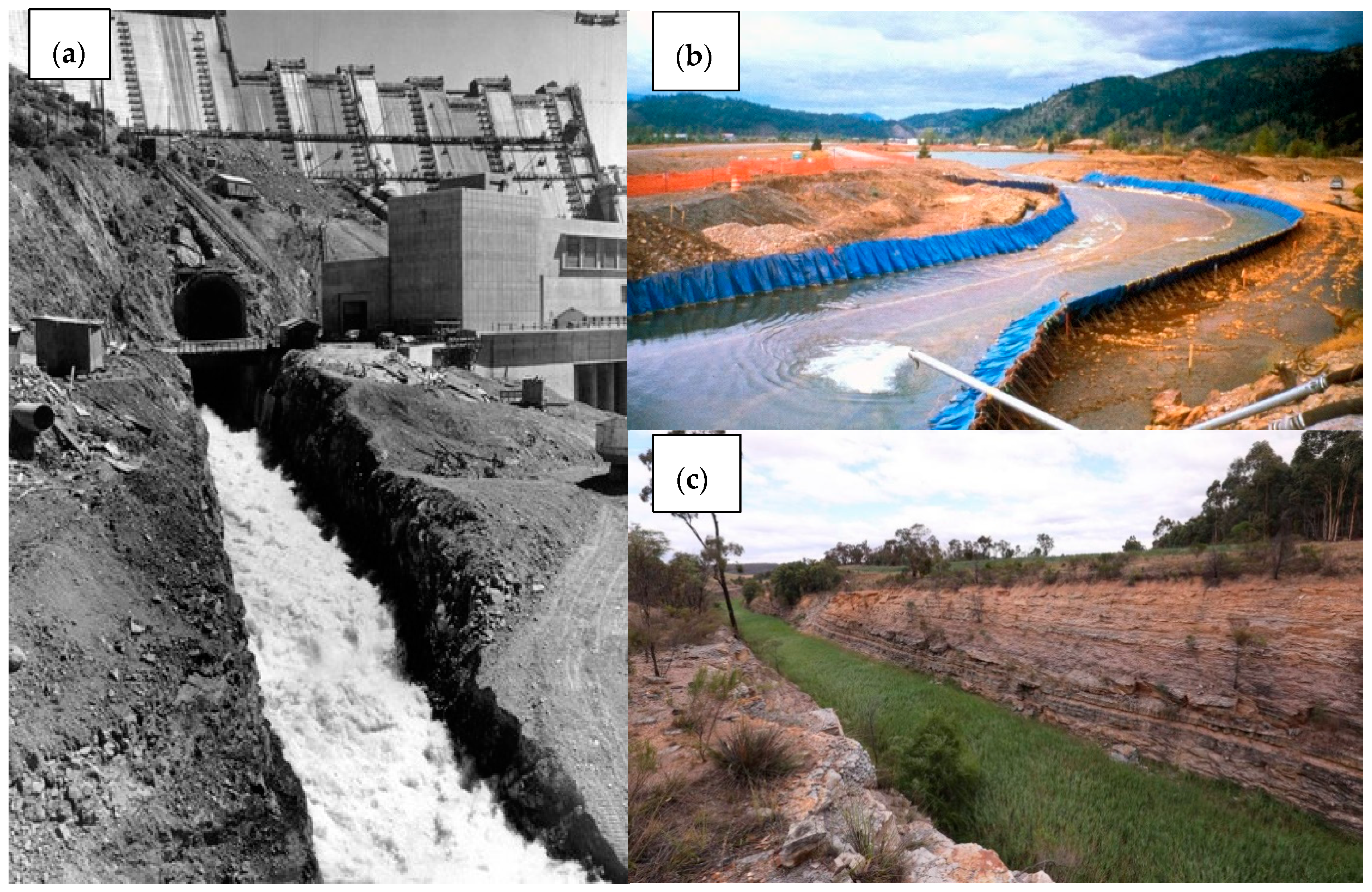
  • Temporary river relocation for construction, such as temporary river relocation channels for dams [26], in which the river channel is temporarily diverted (Figure 2a), and the original channel is dried out to facilitate the construction of the dam or other structure across the river. Rivers can be temporarily diverted to clean up contaminants (e.g., relocation of the Coeur d'Alene River in Idaho for the clean-up of contaminated tailings (Figure 2b)).
  • Permanent relocation channels to make way for infrastructure. Examples are highway construction (such as the diversion of the Wraysbury River for construction of the M25 in the UK [27]) and airport runway expansion [28] or golf courses [29].
  • A particular class of infrastructure relocation is around open-cut mining operations (Figure 2c), in which rivers are relocated to gain access to mineral reserves or materials stored in paleochannels, and to minimise flood risk to adjacent infrastructure [30].
  • Rivers are relocated in association with artisanal mining practices (small-scale open-cast mining) [31,32] either to gain access to valuable deposits within the river bed, or to obtain a supply of water.
  • River relocation is carried out for flood control (e.g., Kaituna River, NZ [33]) to alter the location of the river channel to minimise damage from flooding.
  • Rivers are relocated for land reclamation, such as marsh [34] and wetland restoration [35], by reintroducing freshwater and sediments to enhance vertical accretion to degraded habitats.

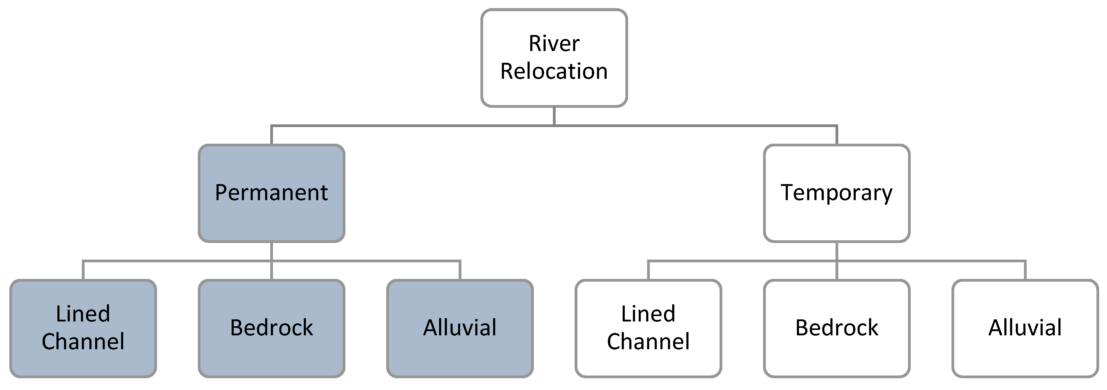
3. River Relocation Classification

Relocated channels can either be temporary or permanent [36], with a varying effort to replicate the original river’s natural condition. The new channel can be cut across a floodplain, blasted through bedrock, or in some cases, constructed as an embankment. Broadly, relocated river channels can be lined or unlined (Figure 3, Table 1).
Unlined channels use the underlying natural materials to create the new channel (such as relocated channels located within a floodplain or through bedrock). These materials can vary among bedrock, alluvial sediments, or a combination of these materials, occasionally reinforced by hard engineering in places along the channel. Lined channels are constructed using artificial materials, such as timber, synthetic geotextiles, covered pipes (concrete inverted siphons), or hard engineering, such as concrete or rip-rap along the channel. In some cases, a new channel is engineered on an embankment that sits higher than the surrounding landscape (for example, through a mining pit) and can also be accompanied by a series of drop structures to maintain the energy and velocity of the river flow within the relocated channel.
This paper concentrates on the issues surrounding permanent river relocation channels (highlighted in blue in Figure 3), as this type of relocation usually presents the most management challenges. Note that artificially cutting off river meanders is a form of relocation, but these short relocations are only considered here where they are cut through bedrock. Note also that the definition of full flow river relocation can be complicated, depending on how much of the flood flows are diverted by the constructed channel. Some just divert up to the bankfull flow and allow the flood flows to continue to pass down the old channel/floodplain section.
We now describe examples of lined, bedrock and alluvial river relocations (with examples of each) from the above classification, and the problems associated with each type. From these examples, and other sources, we summarise the key management challenges associated with these diversion channels. We begin with fully artificial relocated channels (i.e., lined channels) and move to river relocation channels cut in natural rock or sediments.

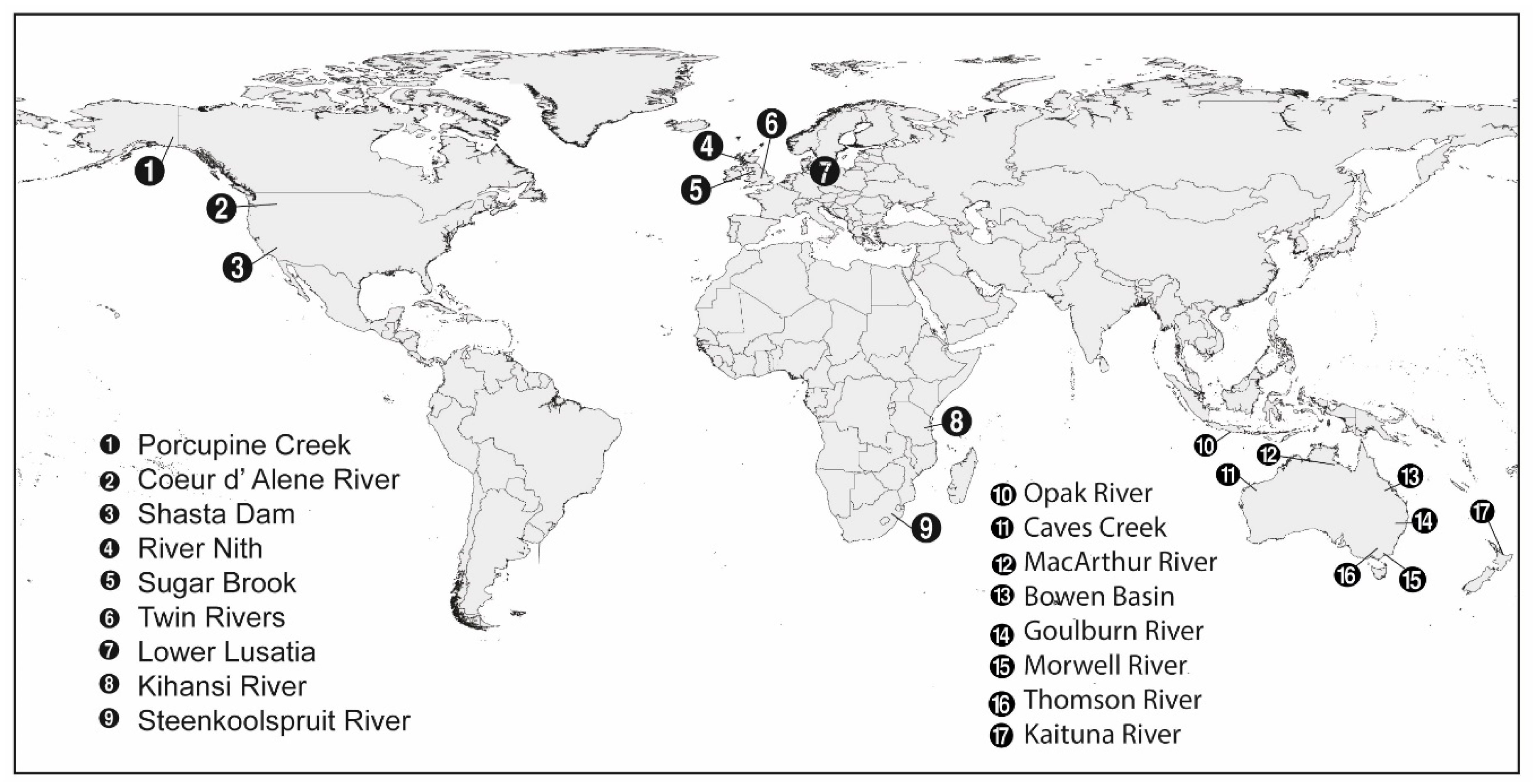
4. Case Studies of River Relocation

4.1. Lined Channel Relocation

Lined channel relocation has been carried out from as early as the 1800s as a consequence of mining. Early watercourse modification was typically for the consumptive use of water through race construction and sluicing [53]. However, many river channels were also relocated to gain access to alluvial materials underneath the channel, such as alluvial gold deposits. The majority of early river relocation efforts were local, small-scale, and predominantly unrecorded [54]; they were comparable to modern artisanal and small-scale open-cast mining river relocations. Larger river relocation channels were constructed using large timber flumes (Figure 4), whereas smaller river relocations were dug as ditches into the surrounding landscape. Historic river relocation flumes lacked geomorphic characteristics of the natural channel; they were fully artificial and were prone to failure during large floods.

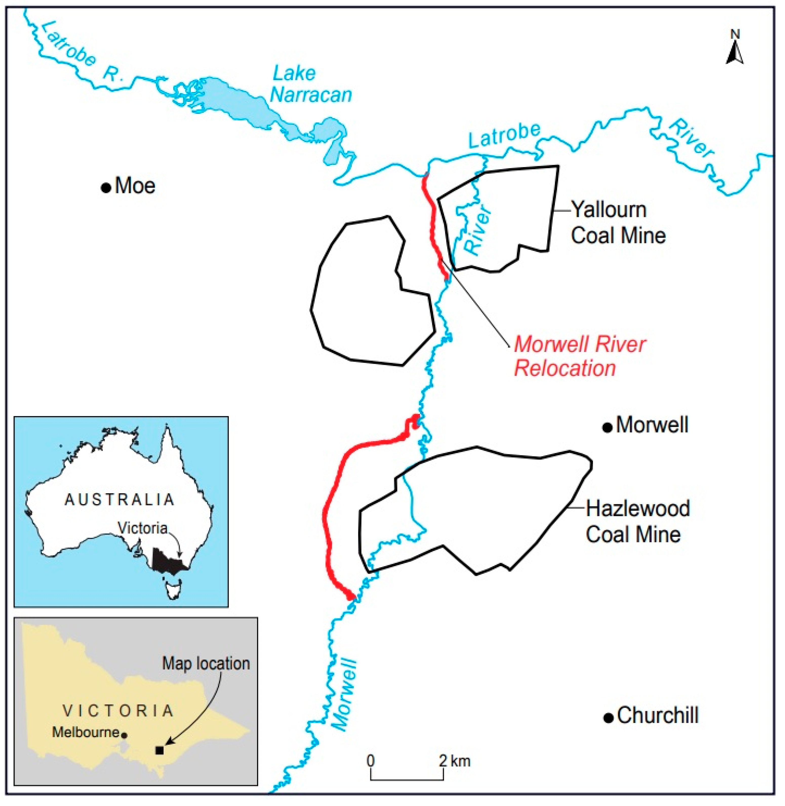
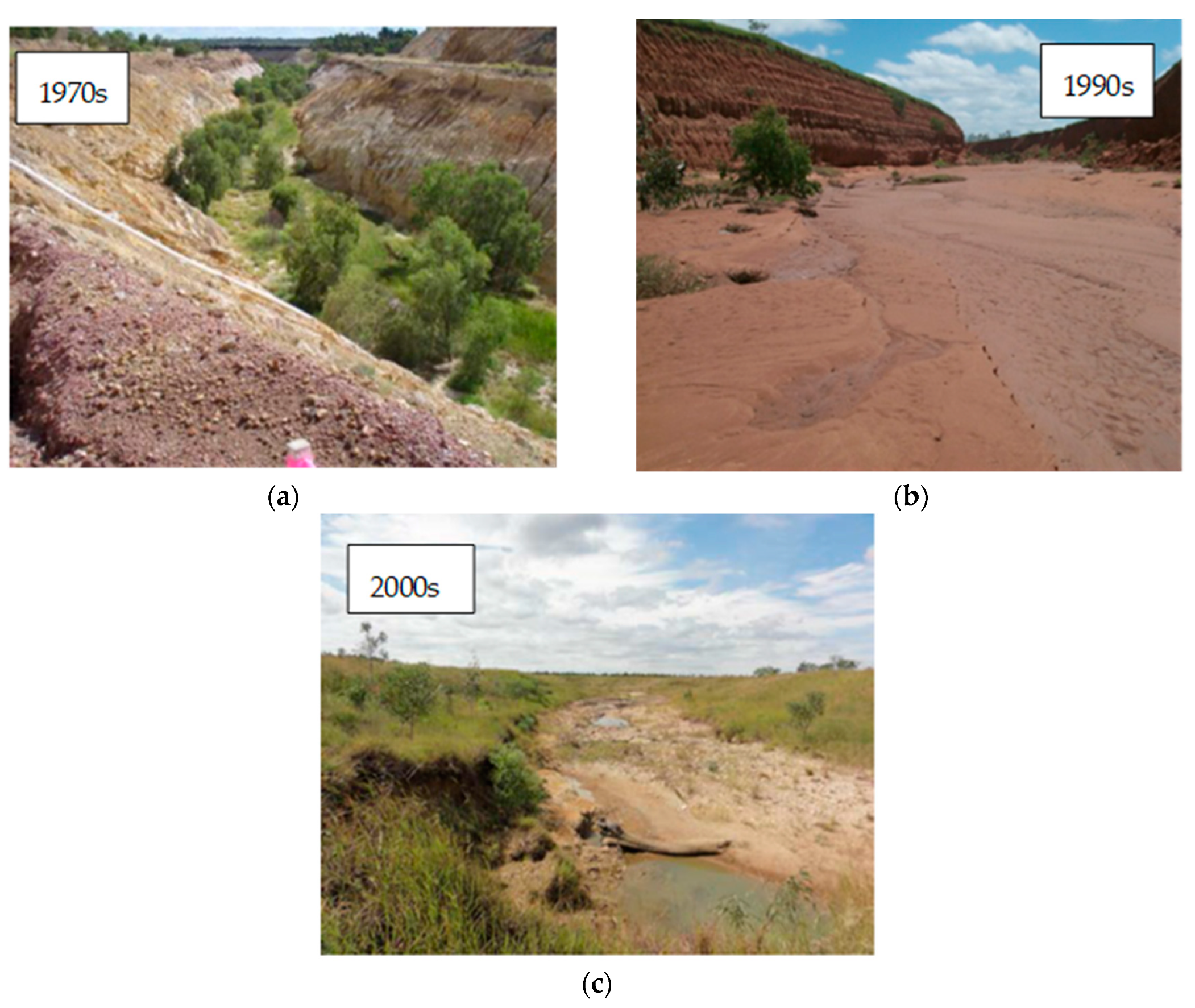
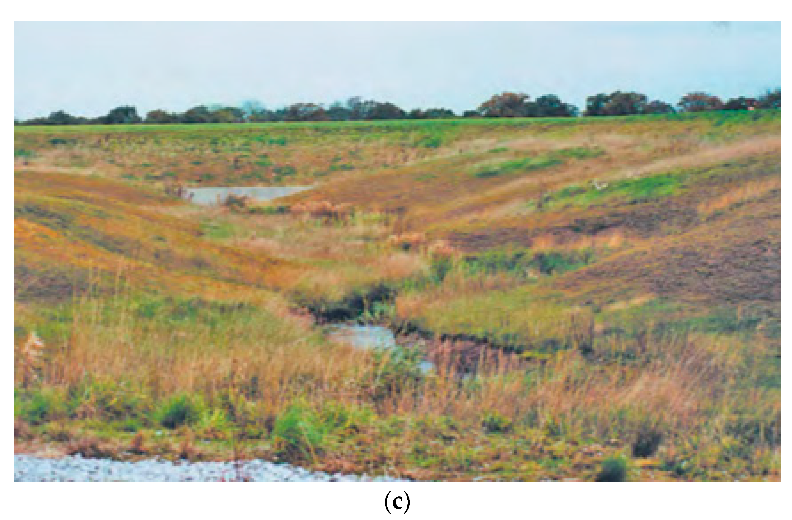
4.2. Case Study: Morwell River Relocation, Victoria, AUS

A particularly challenging type of relocation is where the diverted channel is carried in an elevated flume or channel. A good example of this type of relocation is the Morwell River relocation (MRR) in eastern Victoria, Australia, constructed to access coal reserves at the Yallourn coalmine, Australia’s largest open-cut coal mine [55]. The MRR is a 3.5 km channel carried in an elevated embankment that relocated the river through the middle of the open-cut mine pit to connect with the Latrobe River downstream [56] (Figure 5). The embankment was constructed using engineering fill from 13 million cubic meters of overburden that was stripped from the mine itself [56]. The Morwell river has been previously relocated for coal mining at the Hazlewood coal mine, and its present course is the result of multiple relocation attempts.
The design of the river relocation channel included an artificially meandering channel and a floodplain, with a width that varied between 40 m and 60 m, compared with the 1000 m width of the original natural floodplain [57]. The embankment collapsed during a large flood on 6 June 2012, diverting the Morwell river into the adjacent Yallourn open-cut mine pit (Figure 6). The downstream Latrobe River reversed direction and flowed up the diversion and into the mine pit. The flooding stopped coal production in the state’s major coal mine and threatened power supplies. The mine had considerable trouble disposing of the millions of litres of polluted water that entered the mine [58,59]. The flooding reduced production from the state’s major coal mine to 25% capacity for 4 weeks [60], and the total cost to repair the MRR was between 109 and 150 million AUD [60,61]. Despite its meandering morphology, the diverted channel developed no natural channel characteristics before its eventual failure.

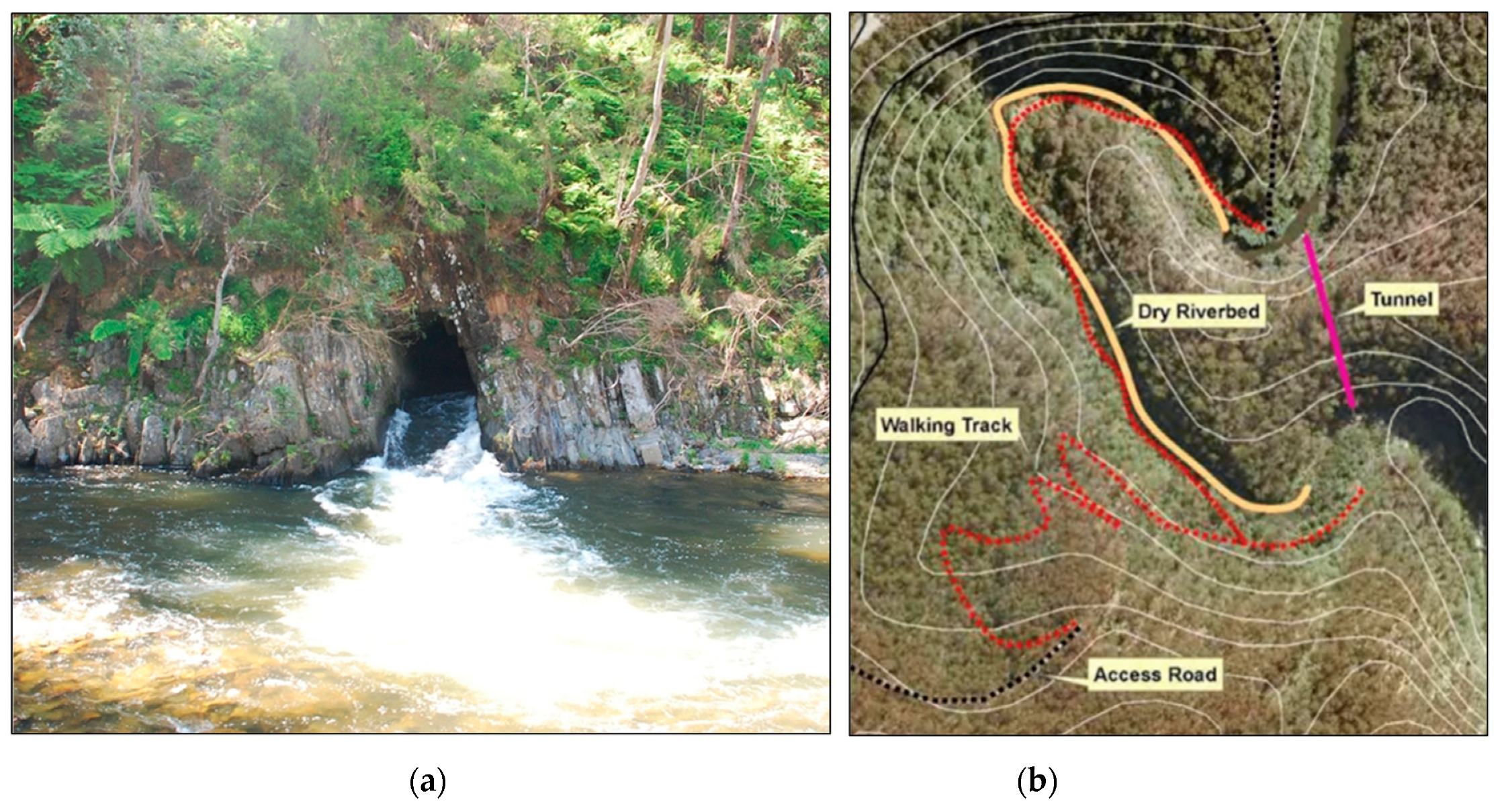
4.3. Bedrock Relocation Tunnels

The simplest river relocation channels are found when a new channel has been blasted through bedrock, commonly as a tunnel through horseshoe bends within sections of river. Thirteen such channel relocation tunnels were constructed for historical gold mining purposes in Victoria, Australia (Figure 7) [62]. The purpose was to dry out the meander bend to allow easy access for alluvial mining. These relocation channels were typically short and utilised the natural features of the watercourse to minimise the cost or distance of the relocated channel. The introduction of dynamite in 1867 [63] allowed for more substantial channels to be constructed. These tunnels disrupt sediment supply through the reach (sediment tends to build-up upstream of the relocation). They also act as barriers to fish passage. In this case, the nationally threatened Australian grayling cannot traverse the high flow velocities in the steep bedrock channel [64].
One of the most common types of river relocation are open channels cut through bedrock. This type of relocation is most common in open-cut mining operations. This type of mining usually takes place higher in the catchment, where floodplains are narrower, and any channel has to be cut into the bedrock valley walls. The purpose is, firstly, to divert tributaries around the mine to avoid flooding, and secondly, to divert the river away from areas that can be mined. The Goulburn River diversion in New South Wales (Australia) is an example of a bedrock river relocation constructed in 1981 to relocate 4 km of the Goulburn river around a coal mine (Figure 2c). The relocated channel is cut 10–20 m deep into a deeply weathered saprolite [65]. The central reaches of the channel relocation were constructed to have a box-like canyon form with benches constructed on the channel banks [66].
The relocated bedrock channel is a simple rectangular channel with vertical walls. Compared to the natural reaches upstream, the relocated channel is steeper and hydraulically smooth, with high stream power. As a result, the channel experiences high erosion rates with dispersive subsoils exposed throughout the channel [67]. The new channel also has simple morphology, with a flat floor, and an unnaturally dense covering of reeds [66]. Also, the bedrock channel cuts across tributaries, producing ‘hanging’ tributaries at each junction. These hanging tributaries become waterfalls during storms and can form gullies. They also completely disrupt up-and-downstream migration of fish, and any form of riverine connectivity between the river and the tributaries. Current rehabilitation strategies are being implemented to improve the stability and design of this relocated channel [68].

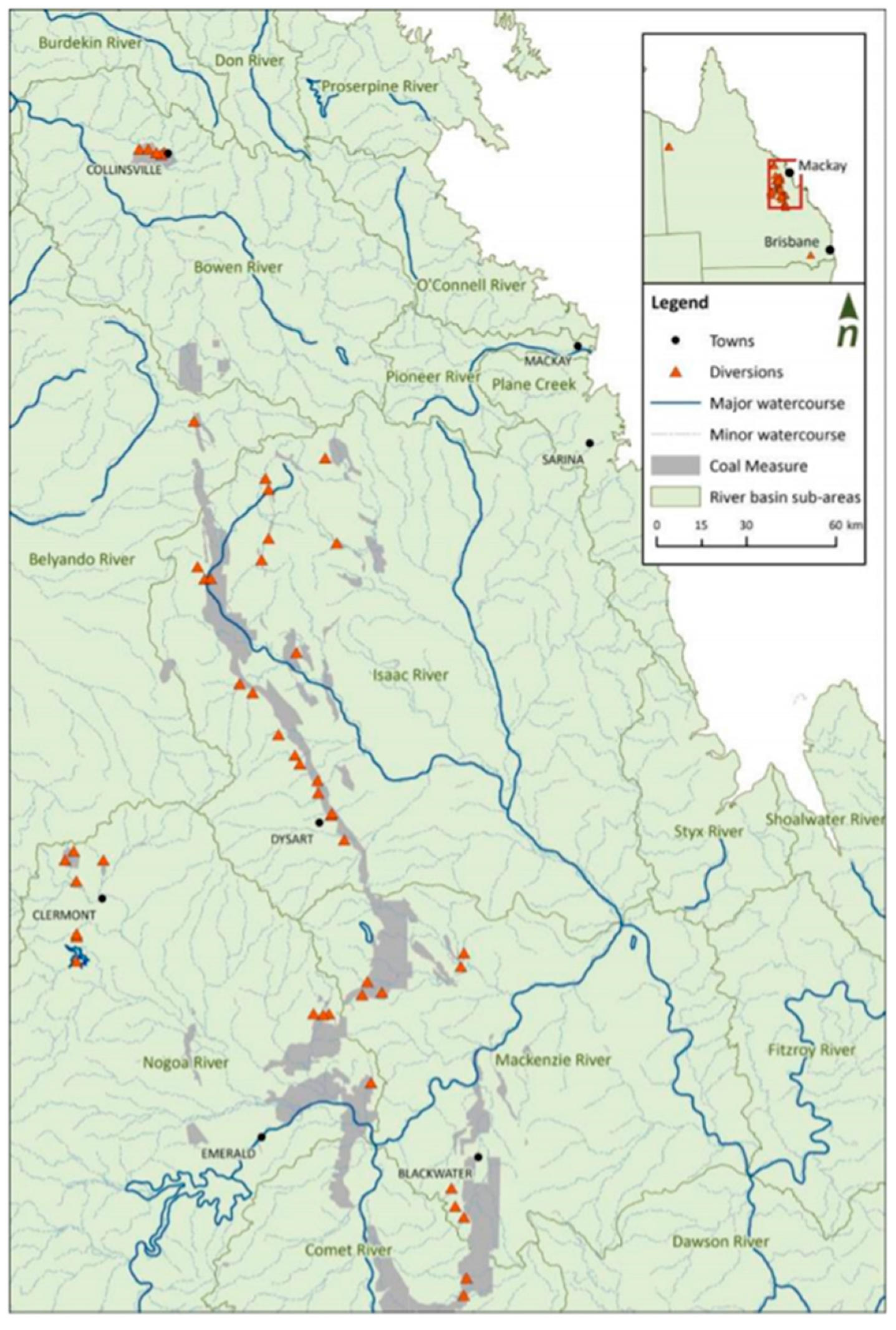
Bedrock Diversions for Coal Mining in the Bowen Basin, Queensland, Australia

Since the 1970s, over 60 full bedrock river relocation channels have been constructed in the Bowen Basin, Queensland (Figure 8), a major coal mining region [69]. Dynamic meandering channels were replaced with relocated channels that were straight and of trapezoidal form to reduce construction costs and maximise the discharge capacity of the river channel [69]. Designs from the 1980s onwards incorporated drop structures to compensate for reduced channel lengths and the accompanying increase in bed slope [69,70].
The Australian Coal Industry Research Program (ACARP) reviewed the performance of river relocations [69,70]. Some relocated channels experienced high erosion rates due to inadequate design widths, increased bed slopes from shortened channel lengths, and increased velocities exacerbated by an absence of vegetation, but conversely, a smaller number experienced high sedimentation [69]. Some were at risk of eroding into adjacent open-cut pits or associated mining infrastructure. The poor performance of the relocated channels (Figure 9) led to a temporary moratorium on the approval of river relocation construction by the Queensland government [71] which lasted for 5 years.
Overall, five key factors were identified that consistently limited the performance of the Bowen Basin relocated channels. These factors were sediment supply and transport, vegetation condition, the occurrence of major flood events in the early years of diversion establishment, overland flow drainage, and the transition between the relocated channel and the natural watercourse [72]. Improved design standards have dramatically improved the performance of Bowen Basin relocations, and these are discussed in Section 6.2 below.

4.4. Alluvial River Relocation Channels

Alluvial river relocations are carried out using natural channel materials, such as in situ alluvial sediments, and they cut across a floodplain rather than into bedrock. In some instances, they can be sculpted to maintain similar channel dimensions and bed grade to the natural channel. Other alluvial river relocation channels also incorporate the floodplain into the channel design.

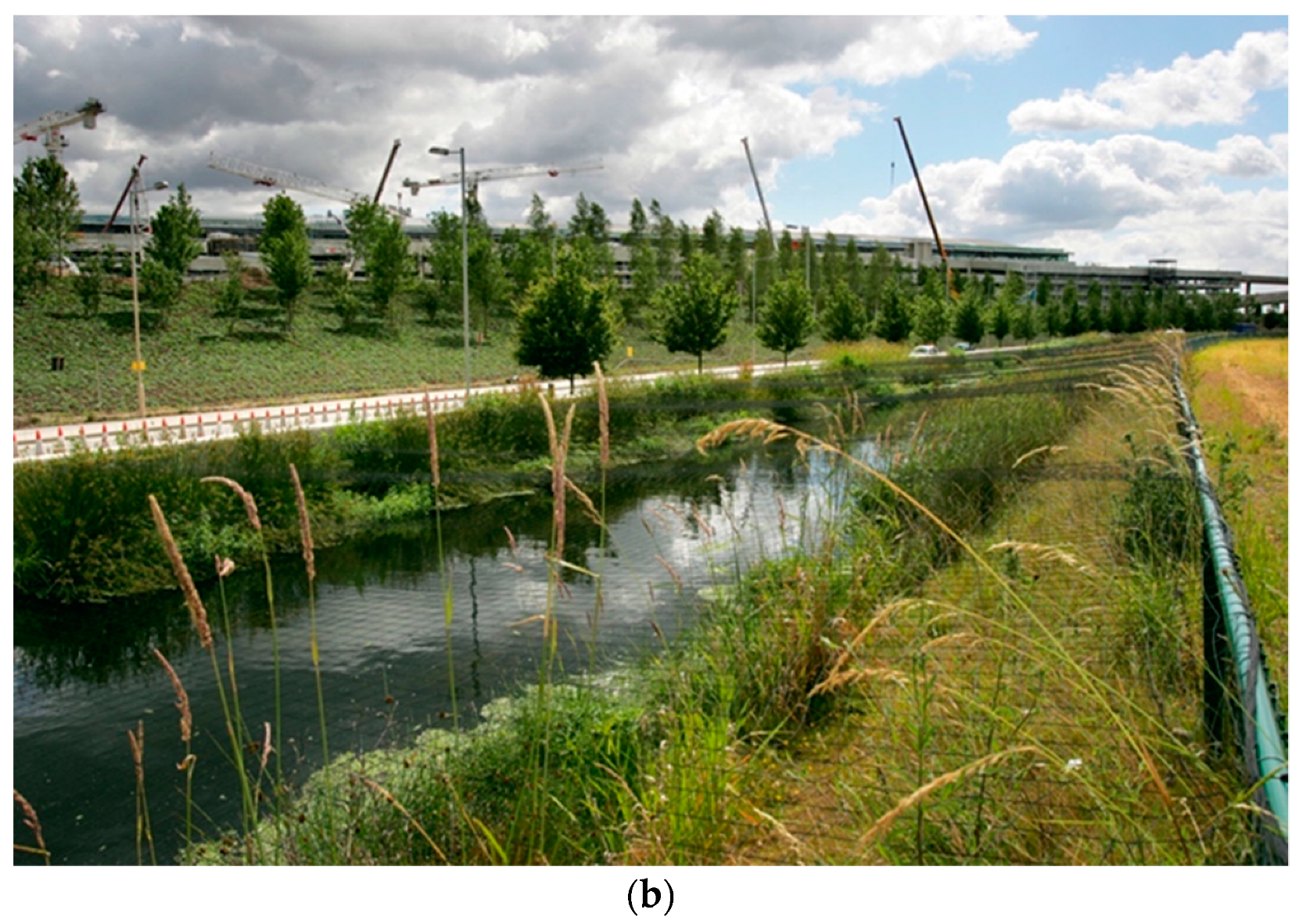
4.4.1. Case Study: Twin Rivers Relocation, Heathrow Terminal 5, UK

Rivers are frequently relocated for construction purposes, either as a temporary measure while building bridges or dams, or permanent diversions for development. There are many examples of airport river relocations, including the River Mole diversion for Gatwick Airport, UK [73], Sugar Brook relocation for Manchester Airport, UK [28], the Twin Rivers relocation for the expansion of Heathrow Terminal 5 [74], and the planned relocation of the Ulwe and Gadhi rivers for the construction of Navi Mumbai airport, India [75].
Many airports are located in areas with limited available land for expansion, resulting in increased pressure to utilise river corridors for continued airport growth, with the economic return of expansion outweighing the cost of river relocation. There are specific management issues for the relocation of rivers for airport construction. As part of the construction process, valleys are backfilled to bring ground levels up to required elevations for runway construction [23]. In addition, contaminants, such as jet fuel and de-icer, can flow into the river system, presenting a significant source of pollution. Birds present an additional challenge, as open bodies of water such as rivers attract avian communities but represent a hazard to aircraft safety.
The expansion of Terminal 5 at Heathrow airport in the UK required two rivers to be relocated. The Duke of Northumberland’s River and the Longford River (known collectively as the Twin Rivers) flowed through the middle of the Terminal 5 project site. Both rivers have a long history, and were originally man-made, constructed to supply royal estates located on the banks of the River Thames [74,76].
To facilitate expansion, the Twin Rivers were relocated around the western perimeter of the airport. The relocated channels were designed to ensure they had the capacity to convey peak flows of 3 m3/s and 1.5 m3/s for the Duke of Northumberland and the Longford, respectively [74]. River relocation developments need to comply with local and national policies, where present. In this instance, the Twin Rivers relocation needed to comply with the EU Floods Directive (Directive 2007/60/EC) and the Flood and Water Management Act (2010), which relay the overarching message that all development must consider and mitigate flood risk, ensuring that this risk is not increased because of river relocation construction [77].
The new channel design saw an increase of open channel, with 95% of the relocation channel occurring in an open channel, compared to 50% in the previous diversion design [78]. This ‘daylighting’ of the channel aimed to enhance the environment, with the inclusion of habitat features designed to provide a minimum of environmental equivalence compared to pre-diversion standards [74]. Habitat features included modifications for fish passage, the addition of in-channel wood, 8000 m2 of pre-planted vegetation, and the provision of alternating berms with rock-filled gabions and logs [74]. A bird exclusion net was also added throughout the entire length of the Twin Rivers channel (Figure 10). A 0.3 mm diameter, lightweight polypropylene netting with a mesh size of 75 mm was selected, as it excludes all hazardous birds but allows exit and entry for a range of invertebrates, such as the emperor dragonfly [74].

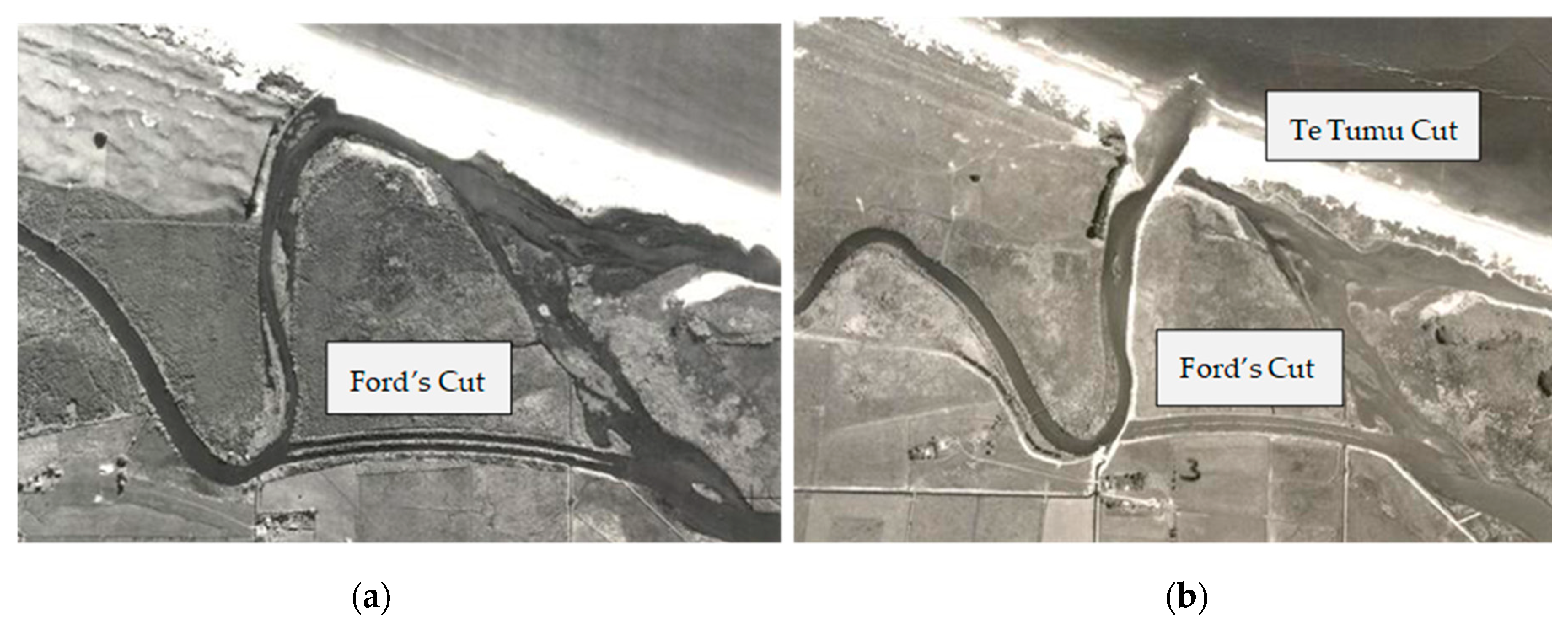
4.4.2. Case Study: Kaituna River Relocation, New Zealand

The Kaituna River is an example of a laterally active river located on the Bay of Plenty, New Zealand. This case study illustrates the cumulative impacts that can arise from river relocation. The Kaituna River is a 50 km long [79] modified river that has been relocated on several occasions. The original course of the river passed through the Papahikahawai Channel into the Ōngātoro/Maketū Estuary. In 1907, during a flood, the Kaituna River broke from its original course due to an avulsion through a sandspit at Te Tumu [80], stopping flow to an adjacent coastal estuary.
Between 1926 and 1928 [81], two parallel chutes were cut to relocate water back into the estuary, becoming known as Ford’s Cut (Figure 11a). Ford’s Cut enabled the river to return to the estuary, however, during the same period, natural channel migration caused the river’s flow to migrate eastward, returning to the estuary via the Papahikahawai Channel [81].
Additional serious flooding occurred again in 1949 and 1951 [80], which resulted in a management response to construct a new mouth for the Kaituna River. The new mouth of the river was commissioned in 1956 and was named the Te Tumu Cut (Figure 11b). The objective of this river relocation was to reduce the frequency and severity of flooding on the Te Puke lowlands, former wetlands that are now surrounding agricultural land [79,82]. The Te Tumu relocation channel could reinforce the natural ‘second mouth’ that occurs during flood events [82].
The previously engineered Ford’s Cut and the Papahikahawai Channel were blocked with a causeway at their upstream ends to maintain full river flow throughout the Te Tumu cut and to potentially reclaim the Maketū Estuary [81]. However, a secondary response to the blocking of Ford’s Cut and the Papahikahawai Channel was the reduction of flow through the old river estuary. The flow reduction caused tertiary issues, such as an increase in salinity which destroyed wetland and reduced the estuary’s ability to flush out sand and mud [82]. The Te Tumu river relocation contributed to sediment infilling and general ecological decline of the estuary [79] and has been described as a venture carried out for the benefit of the farming community at the expense of another community: estuary users [80].
Since the Te Tumu relocation, there have been attempts to restore flow to the estuary and growing support for another channel relocation to combat increased sedimentation and the closing of the estuary mouth [83]. In 1995, the construction of four culverts was undertaken at Ford’s Cut [81] to resupply water back to the Maketū estuary via flapgates following years of concern about the closure of all previous river paths. Domijan [84] estimated that this flow restoration resulted in an additional volume of 100,000 m3 of water entering the estuary per tidal cycle. The addition of water into the estuary was hoped to reduce sediment infilling and restore some of the declining habitat and restore fish stocks or “kaimoana” [85]. The addition of water did assist in reducing the salinity in the upper estuary but there has been no measurable reduction in sedimentation rates [28], with continued poor overall hydrodynamic and ecological improvement [83]. There are plans to construct an additional relocation channel through to the Maketū Estuary to create new wetlands and maximise both community and ecological benefits [85].

5. Implications and Challenges of River Relocation

Lined, bedrock, and alluvial channel relocations have been introduced, with case studies providing examples of each of these types. Each case study highlights some of the challenges surrounding the design, construction, and performance of river relocation channels. In the past, relocated channels were considered successful if they passed all flood flows, did not erode excessively, and did not degrade the river reaches up and downstream. Since the 1990s, higher standards have been demanded of the relocated channels, and they are now expected to maintain biological and aesthetic values in both the channel and adjacent reaches up-and-downstream. In general, relocation channel construction can cause a series of primary changes (defined here as physical changes around the diverted channel), which can then lead to the generation of secondary issues (defined here as physical and biological connectivity issues caused by the primary changes), and then tertiary issues (defined as linked, but perhaps surprising, consequences on biology and human communities caused by secondary issues) (Table 2). The issues arising from channel relocation can be broadly characterised as either fundamental engineering problems, or issues relating to the ability of the relocated channel to behave in a comparable way to a natural channel. As such, the performance of river relocation channels can be considered through the lens of successful engineering, but also in relation to the natural characteristics of the channel that they replaced.

5.1. Fundamental Engineering Performance

Some of the fundamental engineering issues surrounding river relocation involve changes to the dimensions or gradient of the channel, materials, built-in engineered structures such as culverts, and the lining and length of the channel. From an engineering perspective, when a channel is relocated, the fundamental concerns are the ability of the channel to convey flood flow, and the overall structural stability of the channel. Failure of the relocated channel from an engineering perspective consequently means the structural collapse of channel elements, such as culvert failure, embankment breaching, or the overtopping of the structure during flood flow events.

River Relocation Channel Dimensions

Channel conveyance, alongside the sizing of hard engineering materials and culverts, is ultimately determined by the discharge of the river. Most modern relocation channels continue to be trapezoidal in design, developed from size and stability criteria derived from European or North American rivers. These designs focus on the relocation channel being robust and capable of conveying a certain flow efficiently.
Relocated channels are often designed to convey the 100-year average recurrence interval (ARI) flood without overtopping [36]. For river relocation channels designed for mining, a more conservative estimate of rainfall and discharge is typically used to avoid water entering the mining pit. River relocation channels constructed in and around mine sites are designed to withstand a flood with a 100-year average return interval, or even an event once every 1000 or 10,000 years [91]. Conservative design flood standards can lead to artificial channels that are constructed with enlarged flood protection bunds, and channel dimensions that exceed the size of the original channel. Engineering failure within river relocation channels often occurs when the artificial channel is poorly sized, or with materials that do not withstand large floods.
All river relocation channels present an artificial discontinuity between natural sections of a river. This artificial channel seldom has the identical physical characteristics of the adjoining upstream and downstream reaches [64]. River relocation channels tend to be straighter and shorter than the original channel, with a higher bed slope and different channel dimensions (width and depth). River relocation is often expensive, particularly when cutting through bedrock or reinforcing the channel with artificial structures. Because of this, engineers will often attempt to minimise the length and cross-sectional size of the relocated channel, resulting in a new channel that is often substantially shorter and smaller than the original.
Even if the channel dimensions and boundary materials are the same (which might be the case with an alluvial river relocation), the channel will usually be straighter, steeper, or feature a reduced floodplain width [57], prompting heightened erosion within the channel. These issues can be further intensified through the feedback loops of secondary and tertiary problems [76,79]; in other words, a change in channel dimensions can cause increased erosion and unstable banks. These unstable banks can fail, prompting vegetation loss, lower channel roughness, and further channel erosion.
Increased erosion within the channel can lead to amplified incision of adjoining tributaries alongside erosive tributary junctions (where the artificial channel re-joins the natural channel). This can cause sustained secondary issues, such as knickpoint migration from hanging tributaries [65], and increased sediment supply to the main channel. These changes produce tertiary issues, such as disruption of fish passage [36]; loss of habitat [74], species diversity, or assemblages [90]; and reduced water quality [85]. Secondary and tertiary issues can impact adjoining reaches, propagating the impacts of channel relocation both upstream and downstream. In the past, diversion channels were expected to remain as simple engineered channels that carried major floods. Vegetation would typically be removed from the channels to maintain conveyance. More recently, channels have been designed to gradually develop more natural morphology and vegetation, and to have more natural rates of erosion. We now turn to this issue of designing more natural channels.

5.2. Replicating Natural Channels

Government agencies and regulators now demand higher standards of river relocations. This is evident in several of the case studies presented above. Not only must the diversion not harm the river environment up-and-downstream, but the river relocation itself must eventually behave and function like a natural river channel. There is typically a conflict between establishing these natural values in diversions, and the functionality or engineering stability of the river relocation channel [91]. For example, smooth uniform channel beds do not encourage species diversity within the channel [92] yet provide the most efficient flow conveyance.

6. Improving River Relocation Designs

The poor performance of river relocation channels has prompted greater awareness of new channel designs to fulfil both engineering and channel replication requirements. Here, we present examples of recent best management practice approaches to relocation design.

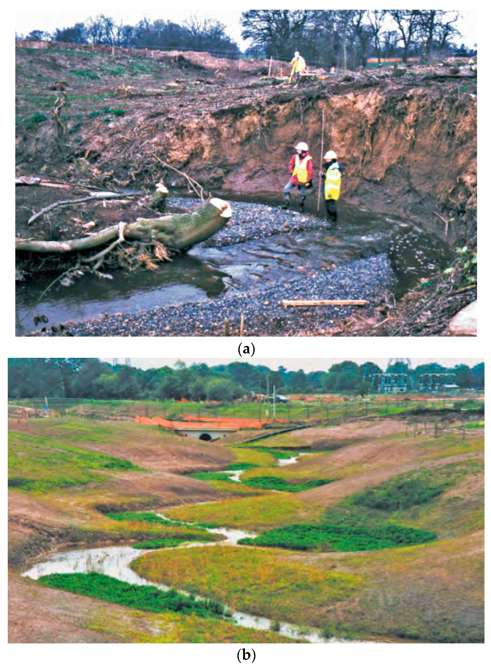
6.1. Case Study: Sugar Brook Relocation, Manchester Airport, UK

The Sugar Brook Valley relocation is an example of an alluvial river relocation that considered the geomorphology and characteristics of a natural river. The Sugar Brook relocation is located next to Manchester Airport, UK. The construction of Manchester airport required the relocation of the Bollin River to facilitate the widening of the first runway [93]. The Bollin River relocation was 780 m long and passed underneath a 25 m embankment. The Sugar Brook relocation is one of two smaller rivers that were relocated to construct a second runway at the airport.
The river relocation was designed to ensure that the majority of the channel is open with a comparable gradient to the original watercourse. A consistent and similar channel gradient is favoured to avoid increased erosion and heightened flow rates within the channel. An appropriate gradient is also essential for maintaining sediment continuity within the channel and maintaining the appropriate stream energy.
The original design of the relocated channel was problematic. Initially, the Sugar Brook relocation required a significant excavation depth to construct the required channel bed level with the resulting excavation (Figure 12a) producing a narrow deep canyon. This design was considered to be geomorphically unreliable due to clay soils and likely undercutting of the toe of slopes, which could accelerate the collapse of high banks [28].
To improve the stability and long-term recovery of the relocated river channel, a new design was used which considered the larger surrounding landscape in which the river is situated. A new river valley and floodplain was sculpted into an acceptable form (Figure 12b), and then a small meandering river channel was constructed within the new valley floor [28]. The Sugar Brook relocation acts as a larger valley-wide river diversion which looked more natural and stable, facilitating overall positive rehabilitation of the channel (Figure 12c).

6.2 Improved Design Using Geomorphic Criteria: Example of the Bowen Basin Mining Relocations

Mining river relocation channels have received increased scrutiny owing to high-profile cases of failure and poor performance. Contemporary mining is now heavily regulated, but despite rigorous engineering practices, the performance of river relocation channels is a concern to mine regulators. In general, there is a risk of failure during mine operations, and secondly there is the long-term stability and subsequent rehabilitation of the river channel to consider. Mining river relocation channels face increasing scrutiny to fulfil long-term environmental objectives. In particular, mining river relocation presents a noteworthy case study, as there is an emerging conflict between establishing natural values within relocated channels, and the functionality or engineering stability of relocation. The risks associated with mining and river relocation have prompted a series of case studies examining the improved design of river relocation channels.

ACARP Geomorphic Criteria

Mining impacts on both the quality and quantity of water are a highly contentious aspect of most mining projects [22,94]. The performance of river relocation channels was studied by a series of ACARP initiatives within the Bowen Basin, Queensland (Figure 8). The result of these investigations was the establishment of specific hydraulic and geomorphic design criteria for these regional watercourses.
Hardie and Lucas [86] assessed 35 natural reaches of streams that had not been altered within the region and identified significant relationships between the hydraulic parameters in three variable stream types (incised, limited capacity, and bedrock controlled). These distinct stream parameters could then be used in the design of new relocated channels, and the rehabilitation of existing channels that were poorly performing or degraded [86]. These hydraulic parameters act as guidelines and establish the ideal range of conditions within each stream type within the region (Table 3).
The hydraulic parameters in the guideline were refined in an additional study that evaluated the performance of 60 relocated channels, where 17 had been constructed following the guidelines. The 17 artificial channels constructed using the guidelines were found to be in better overall condition than the rest of the relocated channels [48]. An outcome of these ACARP projects was the production of a series of updated stream parameter guidelines (Table 4) that provide a design approach for relocated alluvial and bedrock channels. Additional elements were also considered, including the level of sediment supply to the relocation channel, and channel and planform variability [70,72]. This integrated design increased the likelihood of successful vegetation establishment.
In 2014, the Government of Queensland consolidated the earlier principles of design for river relocated channels, based on the ACARP recommendations, to produce a series of design objectives (Table 5). These objectives indicate that relocated channels should be self-sustaining, include geomorphic and vegetation features similar to the regional watercourses, positively contribute to river health values, and impose no long-term liability on the state, the proponent, or the community [16].

7. Long-Term River Relocation Rehabilitation

The previous sections introduced the conflict of establishing natural values within river relocation channels whilst also ensuring engineering functionality and stability. River relocation channels can be criticised for their lack of long-term stability and lack of ecological and environmental attributes in comparison to the original channel. More recently, the importance of identifying river behaviour [95] and geomorphic processes [96] has been highlighted as a necessity for long-term stability of constructed channels.
The overall long-term objective of river relocation channels varies depending on the river’s location, and previous modifications. There are many river relocation channels (such as the Twin Rivers at Heathrow, UK) that have had a long history of modification and are channelised or are constructed on restricted floodplains, so that it is challenging for them to possess all the attributes of a natural river system. Many of the constructed channels have substantially altered boundary conditions, and it may not be appropriate or feasible to rehabilitate the river to its pre-disturbance condition. Instead, it might be more relevant to strive to maximise the beneficial features of the river in its new setting if irreversible of systematic change has occurred [97]. This section focuses on river relocation for mining and the objective of long-term river rehabilitation.
Many environmental impact assessments (or equivalent thereof) now require evidence of long-term river relocation objectives. Rivers relocated for mining purposes are subject to long-term rehabilitation objectives, including a rehabilitation plan for the site to include channel stability and positive environmental outcomes. In Australia, mining river relocation licenses can only be relinquished (that is, returned to the responsibility of the government) once they have proven that the relocation has met the outcome-based conditions stipulated in the mining license [98]. However, difficulty arises, as river relocation channels have both a temporary and permanent role throughout the mine life-cycle. They represent a key element of engineered infrastructure to ensure both the functionality of the mine during its operation and its subsequent rehabilitation after mining has ceased. Stable river relocation designs are important throughout all stages of the mine-cycle and as such pose enormous challenges for water resource managers [82], not least of which is the danger that, at some time over centuries or millennia, the relocated channel could permanently divert into the mining pit.
Post-mining, most river relocation channels are left in their new position, a few are redirected back to their original course [99,100], or in some instances, the river channel is engineered into a pit lake as riverine through-flow to maintain or improve pit lake water quality [101,102]. Rehabilitation programmes are typically designed to ensure safety and minimise potential negative impacts of the closed mine [103]. Robust and stable engineered designs are crucial for flood conveyance during mine operation, with the ecological and geomorphic components of the river course developing more importance for the implementation of rehabilitation programmes.
Consideration of relocated river channel rehabilitation often begins in the design phase. Permanent river relocation channels present a new challenge in that they are designed for the long term, with channels now constructed with an attempt to replicate the natural channel they replace. This is typically carried out using a design criteria approach (e.g., ACARP geomorphic and hydraulic criteria) where available or a reference reach approach. The design criteria approach will use specific hydraulic and hydrologic targets to create a design standard designed to create the required hydraulic conditions within the channel to enable vegetation recovery and the establishment of geomorphic forms. The reference reach approach will use natural channels to establish closure criteria [104]. Blanchette et al. [104] suggest that reference sites should lie within a river’s normal variability and are both sustained and tracked over time. Both approaches advance the historic form of river relocation channels, which have tended to be trapezoidal and lacking geomorphic complexity.

8. Future Research

Many shortcomings in the current practice for river relocations have been highlighted in high-profile failures, such as the Morwell River collapse in Victoria, Australia, or in poor attainment of rehabilitation objectives. White et al. [70,72] highlight the need to revise most current river relocation designs to reduce subsequent impacts to adjacent waterways.
The regional characteristics of natural rivers should be considered during the design of new relocated channels [102]. This is particularly true in the rivers demonstrating behaviour that do not fit the planform or criteria found in European and North American rivers. Greater distinction between perennial and ephemeral watercourses is needed to fully understand the mechanisms that control major channel adjustment, such as flash flooding [81,91]. This is particularly relevant where mining operations are located in arid areas with unusual geomorphology and hydrology. The recovery of vegetation in diverted channels should also be a specific area of research.
Globally, the majority of literature surrounding river relocation is derived from grey literature, or environmental impact assessments, with minimal long-term assessment or evaluation of these projects. Our ability to construct an artificial natural channel is a measure of our understanding of natural channels, which can be limited by poor understanding of various river planforms, such as the anabranching channel, or relocated channels constructed in settings that do not fit European or North American perennial rivers. As such, river relocation channels can be considered as large-scale geomorphic experiments. Within Australia, the ACARP guidelines provide criteria for river relocation designs with explicit consideration of stream type and geomorphology, proving hydraulic reference values for future relocation channel designs. However, these values are best suited to Queensland, with other states and territories lacking equivalent criteria.
Concern about environmental values of river relocations are still emerging. Relocation channels were previously constructed to transfer water from one area to another, with limited concern for the river’s natural values. Now, river relocation channels are planned with a consideration of regional planforms and characteristics of the natural channel, including the high interannual flow variability of Australian rivers [105].

9. Conclusions

This paper introduces the characteristics and challenges of a poorly described class of human impact on streams: river relocation channels. The term ‘river diversion’ has typically been ambiguous, often used for several types of engineering approaches. We suggest that ‘river relocation’ more accurately describes the permanent or temporary relocation of a river channel into a new course. The new course can be lined or unlined, and cut into bedrock or alluvium. A river relocation channel that does not correctly mimic natural channel characteristics can have a profound impact on the overall performance and success of the river relocation.
Traditionally, relocated channels were designed to carry large floods, but at a minimum construction cost. This means that river relocation channels were typically constructed as short, narrow, and steep as possible. The common result is excessive erosion or sedimentation in the new channel, and hanging tributaries. This has secondary consequences, including headward erosion into the upstream reach, disruption to the sediment flow regime into the downstream reach, loss of vegetation, poor water quality, loss of biodiversity, and in some cases, river channel collapse.
Rivers will continue to be relocated for infrastructure projects, flood protection, and mining operations. From an engineering perspective, it is now increasingly important to be able to design and build a permanent river relocation channel that, for the least cost, eventually has the morphology, vegetation, and dynamics of up and downstream reaches of stream. Ideally, relocated river channels should eventually be indistinguishable from the natural counterparts up and downstream. This will only be possible where managers have good understanding of the geomorphology of the river system, and the mechanisms that control major channel adjustment, such as flooding, vegetation, and sediment supply. Overall, the presence of natural features and geomorphic stability will facilitate the long-term recovery of the river relocation. Improved understanding of these natural features will allow for the identification of a natural state and projected behaviour over time. Recent analyses have identified thresholds of stream power for certain river types that have led to improved design. Poor-performing relocated channels can be a major long-term liability to companies, and once relinquished, to governments. Finally, we need to remember that river relocations will be there for millennia and need to be designed accordingly.

Author Contributions

A.F. conceived and conducted the literature review; I.D.R. supervised the project; A.F. and I.D.R. and R.H. wrote the paper; I.D.R. and R.H. provided ongoing reviews to paper drafts.

Acknowledgments

The authors would like to thank BHP-Billiton and the George Lansell Memorial Scholarship (the University of Melbourne) for financial assistance for this project. The authors wish to acknowledge the cartographic services of Chandra Jayasuriya for the production of Figure 5.

Conflicts of Interest

The authors declare no conflict of interest. The founding sponsors had no role in the design of the study; in the collection, analyses, or interpretation of data; in the writing of the manuscript, and in the decision to publish the results.

References

  1. Rosenberg, D.M.; McCully, P.; Pringle, C.M. Global-Scale Environmental Effects of Hydrological Alterations: Introduction. Bioscience 2000, 50, 746–751. [Google Scholar] [CrossRef]
  2. Tharme, R.E. A Global Perspective on Environmental Flow Assessment: Emerging trends in the development and application of environmental flow methodologies for rivers. River Res. Appl. 2003, 19, 397–441. [Google Scholar] [CrossRef]
  3. Halim, Y. The impact of human alterations of the hydrological cycle on ocean margins. Ocean Margin Process. Glob. Chang. 1991, 9, 301–327. [Google Scholar]
  4. Keller, E.A. Channelization: Environmental, geomorphic and engineering aspects. In Geomorphology and Engineering; Coates, D.R., Ed.; Dowden, Hutchinson and Ross Inc.: London, UK, 1976; pp. 115–140. [Google Scholar]
  5. Brookes, A. Downstream morphological consequences of river channelization in England and Wales. Geogr. J. 1985, 151, 57–62. [Google Scholar] [CrossRef]
  6. Brookes, A. Response of Aquatic Vegetation to Sedimentation Downstream from River Channelisation Works in England and Wales. Biol. Conserv. 1986, 38, 351–367. [Google Scholar] [CrossRef]
  7. Brandt, S.A. Classification of geomorphological effects downstream of dams. Cantena 2000, 40, 375–401. [Google Scholar] [CrossRef]
  8. Kingsford, R.T. Ecological impacts of dams, water diversions and river management on floodplain wetlands in Australia. Aust. Ecol. 2000, 25, 109–127. [Google Scholar] [CrossRef]
  9. Fantin-Cruz, I.; Pedrollo, O.; Girard, P.; Zeilhofer, P.; Hamilton, S.K. Changes in river water quality caused by a diversion hydropower dam bordering the Pantanal floodplain. Hydrobiologia 2016, 768, 223–238. [Google Scholar] [CrossRef]
  10. Poff, N.L.; Schmidt, J.C. How dams can go with the flow. Science 2016, 353, 1099–1100. [Google Scholar] [CrossRef] [PubMed]
  11. Petts, G.E. Time-scales for ecological change in regulated rivers. In Regulated Streams; Craig, J.F., Kemper, J.B., Eds.; Plenum: London, UK, 1987; pp. 257–266. ISBN 0306426749. [Google Scholar]
  12. Darby, S.; Sear, D. River Restoration: Managing the Uncertainty in Restoring Physical Habitat; John Wiley and Sons, Ltd.: Chichester, UK, 2008; pp. 1–315. [Google Scholar]
  13. Webber, M.; Crow-Miller, B.; Rogers, S. The South-North Water Transfer Project: Remaking the geography of China. Reg. Stud. 2017, 51, 370–382. [Google Scholar] [CrossRef]
  14. Hooke, J.M. Human impacts on fluvial systems in the Mediterranean region. Geomorphology 2006, 79, 311–335. [Google Scholar] [CrossRef]
  15. Chatelliers, M.C.D.; Reygrobellet, J.L. Interactions between geomorphological processes, benthic and hyporheic communities: First results on a by-passed canal of the french upper Rhône river. Regul. Rivers Res. Manag. 1990, 5, 139–158. [Google Scholar] [CrossRef]
  16. Department of Natural Resources and Mines. Guideline: Works that Interfere with Water in a Watercourse—Watercourse Diversions. September, 2014. State of Queensland. pp. 1–43. Available online: http://www.dnrm.qld.gov.au/__data/assets/pdf_file/0015/212424/guideline-watercourse-diversions.pdf (accessed on 28 September 2018).
  17. Erskine, W.D. Channel response to large-scale ricer training works: Hunter River, Australia. Regul. Rivers Res. Manag. 1992, 7, 261–278. [Google Scholar] [CrossRef]
  18. Soar, P.J.; Thorne, C.R. Channel Restoration Design for Meandering Rivers; U.S Army Corps of Engineers: Vicksburg, MS, USA, 2011; pp. 1–454.
  19. Yevjevich, V. Water diversions and Interbasin transfers. Water Int. 2001, 26, 342–348. [Google Scholar] [CrossRef]
  20. McEwan, A.L. The Failure of and Remedials to a River diversion for an opencast mine in the Witbank Coalfields of South Africa. Mine Water and Environment. In Proceedings of the 1999 IMWA Congress, Sevilla, Spain, 13–17 September 1999; pp. 79–85. [Google Scholar]
  21. Water Act. Available online: http://www.austlii.edu.au/cgibin/download.cgi/au/legis/cth/consol_act/wa200783 (accessed on 26 September 2018).
  22. Kemp, D.; Bond, C.J.; Franks, D.M.; Cote, C. Mining, water and human rights: Making the connection. J. Clean. Prod. 2010, 18, 1553–1562. [Google Scholar] [CrossRef]
  23. Minerals Council of Australia. Water Accounting Framework for the Minerals Industry, User Guide, Version 1.2. Available online: http://www. minerals. org. au/focus/sustainable_development/water_accounting (accessed on 26 September 2018).
  24. Mays, L.W. A very brief history of hydraulic technology during antiquity. Environ. Fluid Mech. 2008, 8, 471–484. [Google Scholar] [CrossRef]
  25. Cronin, L. A Journey through Ancient Kingdoms and Natural Wonders; World Heritage Sites of Australia, New Zealand and South East Asia; Reed Books: Sydney, Australia, 1995; p. 170. ISBN 9780730104889. [Google Scholar]
  26. Ratnayaka, D.D.; Brandt, M.J.; Johnson, K.M. Twort’s Water Supply, 6th ed.; Elsevier Ltd.: Oxford, UK, 2009; p. 744. ISBN 978-0-7506-6843-9. [Google Scholar]
  27. Petts, J. Handbook of Environmental Impact Assessment: Volume 2: Impact and Limitations; John Wiley and Sons, Ltd.: Chichester, UK, 2009; pp. 1–464. ISBN 9781444311495. [Google Scholar]
  28. Seddon, C. Diversion of a River Valley. Manual of River Restoration Techniques. 2013, pp. 1–5. Available online: http://www.therrc.co.uk/MOT/Final_Versions_%28Secure%29/11.1_Sugar_Brook.pdf (accessed on 26 September 2018).
  29. Holmes, P.J.; Meadows, M. Southern African Geomorphology: Recent Trends and New Directions; Sun Media Bloemfontein: Bloemfontein, South Africa, 2012; p. 431. ISBN 978-1-920382-02-5. [Google Scholar]
  30. Atkinson, S.; Markham, A.; Rafty, M.; Heyting, M. Pilbara Creek Diversions: Resilience gained through increased ore recovery and an integrated approach to design. In Proceedings of the AUSIMM Iron Ore Conference, Perth, Australia, 24–26 July 2017; pp. 1–20. [Google Scholar]
  31. Hinton, J.J.; Veiga, M.M.; Veiga, A.T.C. Clean artisanal gold mining: A utopian approach. J. Clean. Prod. 2003, 11, 99–115. [Google Scholar] [CrossRef]
  32. Byizigiro, R.V.; Raab, T.; Maurer, T. Small-scale open cast mining: An important research field for anthropogenic geomorphology. Die Erde—J. Geogr. Soc. Berl. 2015, 146, 213–231. [Google Scholar] [CrossRef]
  33. Mawer, J.C. Morphology of the Te Tumu Cut Under the Potential Re-Diversion of the Kaituna River. Ph.D. Thesis, University of Waikato, Hamilton, New Zealand, 2012; pp. 1–158. [Google Scholar]
  34. Ward, G.H.; Irlbeck, M.J.; Montagna, P.A. Experimental River Diversion for Marsh Enhancement. Estuaries 2002, 25, 1416–1425. [Google Scholar] [CrossRef]
  35. Wang, H.; Steyer, G.D.; Couvillion, B.R.; Beck, H.J.; Rybczyk, J.M.; Rivera-Monroy, V.H.; Krauss, K.W.; Visser, J.M. Predicting landscape effects of Mississippi River diversions on soil organic carbon sequestration. Ecosphere 2017, 8, 1–15. [Google Scholar] [CrossRef]
  36. Fisher, K.; Ramsbottom, D. River Diversions: A Design Guide; Thomas Telford Publishing: London, UK, 2001; p. 176. ISBN 9780727729590. [Google Scholar]
  37. Eakin, H.M. The Porcupine Gold Placer District, Alaska; U.S Geological Survey Bulletin: Washington, DC, USA, 1919; pp. 1–29.
  38. National Research Council of the National Academies. The Coeur d’ Alene System. In Superfund and Mining Megasites: Lessons from the Coeur d’ Alene River Basin; National Academies Press: Washington, DC, USA, 2005; pp. 47–484. [Google Scholar]
  39. Rocca, A. Shasta Lake: Boomtowns and the Building of the Shasta Dam; Arcadia Publishing: Dover, NH, USA, 2002; p. 64. ISBN 0-7385-2076-4. [Google Scholar]
  40. Gilvear, D.; Perfect, C. Clay Lined River. Manual of River Restoration Techniques. 2013, pp. 1–7. Available online: http://www.therrc.co.uk/sites/default/files/projects/p449.pdf (accessed on 27 September 2018).
  41. The River Restoration Center. River Restoration News. 2000. Available online: http://www.therrc.co.uk/site/default/files/newsletters/issue5.pdf (accessed on 28 September 2018).
  42. Risbridger, T. Terminal 5 Twin Rivers Diversion- Critical Sub-Project in Airport’s T5 expansion Programme. Water Treat Supply. 2007. Available online: http://www.waterprojectsonline.com/case_studies/2007/EAHeathrow T5 River Diversion 2007.pdf (accessed on 28 September 2018).
  43. Pennington, M.; Spence, J. Piled foundations for the M25 motorway near Heathrow Airport. In Advances in Transportation Geotechnics; Ed, E., Yu, H.S., Glenn, M.D., Andrew, D., Nick, T., Eds.; CRC Press: Nottingham, UK, 2008; pp. 453–457. ISBN 978-0-415-47590-7. [Google Scholar]
  44. Schultze, M.; Pokrandt, K.H.; Hille, W. Pit lakes of the Central German lignite mining district: Creation, morphometry and water quality aspects. Limnol.—Ecol. Manag. Inland Waters 2010, 40, 148–155. [Google Scholar] [CrossRef]
  45. Vandvik, V.; Måren, I.E.; Ndangalasi, H.J.; Taplin, J.; Mbago, F.; Lovett, J.C. Back to Africa: Monitoring post-hydropower restoration to facilitate reintroduction of an extinct-in-the-wild-amphibian. Ecosphere 2014, 5, 1–17. [Google Scholar] [CrossRef]
  46. Harvey, M.; Pearcey, M.; Price, K.; Devkota, B. Geomorphic, hydraulic and sediment transport modelling for mine related channel realignment—Case Study: Caves Creek, Pilbara, Western Australia. In Hydrology and Water Resources Symposium 2014; Engineers Australia: Queensland, Australia, 2014; pp. 259–266. [Google Scholar]
  47. McArthur River Mining. Memorandum. September 2007, Edition 6. 2007, pp. 1–8. Available online: http://www.mcarthurrivermine.com.au/en/publications/MemorandumMagazine/MemoranduM_issue6(1).pdf (accessed on 27 September 2018).
  48. Hallgath, A.; Pearson, B.A. Watercourse diversions relinquishment in Queensland—A risk-based approach to monitoring. In Mine Closure 2016; Fourie, A.B., Tibbett, M., Eds.; Australian Center for Geomechanics: Perth, Australia, 2016; pp. 447–460. [Google Scholar]
  49. Ulan Coal Glencore. Goulburn River Diversion Erosion and Sediment Control Plan. ULN SD PLN 0130. 2017, pp. 1–38. Available online: http://www.ulancoal.com.au/en/environment/EnvironmentManagementPlan/Goulburn%20River%20Diversion%20Erosion%20Sediment%20Control%20Plan.pdf (accessed on 28 September 2018).
  50. Spark, H.; Temple, L. Morwell River Diversion. ACAA.06. Ashton Coal. Appendix 1. Bowmans Creek Diversion Response to Submissions. 2010, pp. 1–7. Available online: http://www.ashtoncoal.com.au/icms_docs/254841_response-to-submissions-part-1.pdf (accessed on 28 September 2018).
  51. Victorian Heritage Database. Thomson River Diversion Tunnel Site. 2018; pp. 1–8. Available online: http://vhd.heritagecouncil.vic.gov.au/places/10756 (accessed on 27 September 2018).
  52. Monchy, P. Kaituna River Re-diversion and wetland creation project. In Assessment of Environmental Effects-Summary; Bay of Plenty Regional Council: Whakatane, New Zealand, 2014; pp. 1–11. [Google Scholar]
  53. Lawrence, S.; Davies, P. Learning about landscape: Archaeology of water management in colonial Victoria. Aust. Archeol. 2012, 74, 47–54. [Google Scholar] [CrossRef]
  54. Cosgrove, D. An elemental division: Water control and engineered landscape. In Water, Engineering and Landscape; Cosgrove, D., Petts, G., Eds.; Belhaven Press: London, UK, 1990; pp. 1–11. [Google Scholar]
  55. Mason, L.; Unger, C.; Lederwasch, A.; Razian, H.; Wynne, L.; Giurco, D. Adapting to Climate Risks and Extreme Weather: A Guide for Mining and Mineral Industry Professionals; National Climate Change Adaptation Research Facility: Gold Coast, Australia, 2013; p. 76. ISBN 978-1-925039-24-5. [Google Scholar]
  56. Laurence, D.; Stamford, C.; Barry, S.; Oosting, N.; Andryszczk, H.; Fawsett, M.; Jones, D. A Guide to Leading Practice Sustainable Development in Mining; Australian Government Department of Resources and Tourism: Canberra, Australia, 2011; pp. 1–204. ISBN 978-1-92-1812-49-1.
  57. Hardie, R.; Nat, M.; Hall, D.; Tilleard, J. Design of a river for a modified environment. In Hydro 2000: Interactive Hydrology; Institute of Engineers: Barton, ACT, Australia, 2000; pp. 1024–1029. ISBN 0957824114. [Google Scholar]
  58. Treadwell, S.; Dettrick, D. Morwell River Diversion Collapse Environmental Risk Assessment; Sinclair Knight Merz: Sydney, Australia, 2012; pp. 1–105. [Google Scholar]
  59. EPA Victoria. Yallourn Mine—Community Information. Publication 1494; August 2012. Available online: http://www.epa.vic.gov.au/~/media/Publications/1494.pdf (accessed on 27 September 2018).
  60. Song, M. $109m bill for Yallourn. In Latrobe Valley Express; Latrobe Valley Express Partnership: Morwell, Australia, 2012. [Google Scholar]
  61. CLP Holdings. Media Release: CLP Holdings Limited announces 2013 Annual Results. 27 February 2014, pp. 1–2. Available online: https://www.clpgroup.com/en/Media-Resources-site/Current%20Releases/20140227_Eng.pdf (accessed on 27 September 2018).
  62. Victorian Heritage Register. Thomson River Diversion Tunnel Site. 2017. Available online: http://vhd.heritagecouncil.vic.gov.au/places/10756 (accessed on 27 September 2018).
  63. Hartman, H.L.; Mutmansky, J.M. Introductory Mining Engineering, 2nd ed.; John Wiley and Sons: Hoboken, NJ, USA, 2002; pp. 1–570. ISBN 0-471-34851-1. [Google Scholar]
  64. Welsh, L.; Travers, I. Thomson River Fishway. In Heritage Impact Statement; Extent Heritage Pty. Ltd.: Sydney, Australia, 2017; pp. 1–24. [Google Scholar]
  65. Ulan Coal Glencore. Goulburn River Diversion Remediation Plan. ULN SD PLN 0054. 2016, pp. 1–120. Available online: http://www.ulancoal.com.au/en/environment/EnvironmentManagementPlan/Goulburn%20River%20Diversion%20Remediation%20Plan.pdf (accessed on 28 September 2018).
  66. URS. Goulburn River Diversion—Long Term Stability Strategy; Ulan Coal Mines Limited.: Sydney, Australia, 2009. [Google Scholar]
  67. Eco Logical Australia Pty Limited. Goulburn River Diversion Rehabilitation Works—Vegetation Assessment and Revegetation Recommendations; Ulan Coal Mines Limited.: Sydney, Australia, 2014. [Google Scholar]
  68. Ulan Coal Glencore. Plan for Goulburn River Diversion Erosion and Sediment Control Plan. ULN SD PLN 0130; Environment and Community Manager, 2017; pp. 1–38. Available online: http://www.ulancoal.com.au/en/environment/EnvironmentManagementPlan/Erosion-and-Sediment-Control-Plan.pdf (accessed on 28 September 2018).
  69. White, K.; Hardie, R. Maintenance of Geomorphic Processes in Bowen Basin River Diversions. ACARP Project C8030. 2000. Available online: https://trove.nla.gov.au/version/43316977 (accessed on 28 September 2018).
  70. White, K.; Lucas, R.; Hardie, R.; Moar, D.; Blackham, D. Criteria for Functioning River Landscape Units in the Mining and Post Mining Landscapes. Report prepared for ACARP Project C20017. 2014. Available online: https://www.acarp.com.au/abstracts.aspx?repId=C20017 (accessed on 28 September 2018).
  71. Department of Natural Resources and Mines. Guideline: Works that Interfere with Water in a Watercourse: Watercourse Diversions; State of Queensland: Queensland, Australia, 2014; pp. 1–43.
  72. White, K.; Hardie, R.; Lucas, R.; Merritt, J.; Kirsch, B. The evolution of watercourse diversion design in central Queensland coal mines. In Proceedings of the 7th Australian Stream Management Conference, At Townsville, Australia, 27–30 July 2014; Vietz, G., Rutherfurd, I.D., Hughes, R., Eds.; University of Melbourne: Victoria, Australia, 2014; pp. 338–348, ISBN 978 0 7340 5038 0. [Google Scholar]
  73. CEEQUAL. The Twin Rivers Diversion Scheme. 1 January 2005. Available online: http://www.ceequal.com/case-studies/the-twin-rivers-diversion-scheme/ (accessed on 27 September 2018).
  74. Palmer, D.; Wilbraham, P. Heathrow Terminal 5: Twin rivers diversion. Civ. Eng. 2008, 161, 25–29. [Google Scholar] [CrossRef]
  75. Purohit, A.A.; Vaidya, M.M.; Kudale, M.D. Application of unstructured mesh modelling in evolving SGE of an airport at the confluence of multiple rivers in a macro tidal region. World Acad. Sci. Eng. Technol. Int. J. Environ. Chem. Ecol. Geol. Geophys. Eng. 2017, 11, 241–255. [Google Scholar]
  76. Clark, P.B.; Palmer, D.K.; Joyce, P.; Pether, R.V. Environmental aspects of the hydraulic design for the twin rivers diversion for Terminal 5, Heathrow Airport. In Environmental Hydraulics and Sustainable Water Management; Lee, J.H.W., Lam, K.M., Eds.; Taylor & Francis: Abingdon, UK, 2004; pp. 847–852. ISBN 0415365465. [Google Scholar]
  77. AMEC. Heathrow’s North-West Runway, Assessment of Flood Risk. AMEC Environment and Infrastructure; Heathrow Airport Limited.: Heathrow, UK, 2014; pp. 1–52. [Google Scholar]
  78. Lister, B. Heathrow Terminal 5: Enhancing environmental sustainability. Civ. Eng. 2008, 161, 21–24. [Google Scholar] [CrossRef]
  79. Goodhue, N.D. Hydrodynamic and Water Quality Modelling of the Lower Kaituna River and Maketu Estuary. Ph.D. Thesis, University of Waikato, Hamilton, New Zealand, 2007; pp. 1–165. [Google Scholar]
  80. Tortell, P. Public Involvement in the Search for a Solution to the Problems of the Maketu Estuary. In Proceedings of the 1985 Australasian Conference on Coastal and Ocean Engineering, Institute of Civil Engineers, Adelaide, Australia, 4–8 December 1985; pp. 256–269. [Google Scholar]
  81. Wallace, P. Fords Cut. History and Bank Erosion Assessment. Report prepared for Environment Bay of Plenty. 2008; pp. 1–23. Available online: https://www.boprc.govt.nz/media/32659/pwallace-090803-fordscuthistory.pdf (accessed on 27 September 2018).
  82. Boothway, D. Room for the River—A New Zealand Perspective. In Hydrology and Water Resources Symposium 2014; Engineers Australia: Queensland, Australia, 2014; pp. 670–677. ISBN 9781922107190. [Google Scholar]
  83. Tuckey, B. Kaituna River to Maketu Estuary Re-Diversion: Model Calibration and Initial Hydrodynamic Impact Assessment; DHI Water and Environment Limited.: Auckland, New Zealand, 2009; pp. 1–63. [Google Scholar]
  84. Domijan, N. The hydrodynamic and estuarine physics of Maketu Estuary. Ph.D. Thesis, University of Waikato, Hamilton, New Zealand, 2000. [Google Scholar]
  85. Everitt, S.; Monchy, P. Kaituna River Re-Diversion and Wetland Creation Project: Scoping Report for Assessment of Environmental Effects; Bay of Plenty Regional Council Environmental Publication: Whakatāne, New Zealand, 2013; pp. 1–29. [Google Scholar]
  86. Hardie, R.; Lucas, R. Bowen Basin River Diversions Design and Rehabilitation Criteria. Report prepared for ACARP Project C9068, Fisher Stewart, 2002. Available online: https://www.acarp.com.au/abstracts.aspx?repId=C8030_C9068 (accessed on 28 September 2018).
  87. Canadian Environmental Assessment Agency. Rainy River Project Environmental Assessment Report; Canadian Environmental Assessment Agency: Ottawa, ON, Canada, 2015; pp. 1–231. ISBN 978-1-100-25429-6.
  88. Schoenheinz, D.; Grünewald, U.; Koch, H. Aspects of Integrated Water Resources Management in River Basins Influenced by Mining Activities in Lower Lusatia. Global Change: Challenges for regional Water Resources. Die Erde—J. Geogr. Soc. Berl. 2011, 142, 163–186. [Google Scholar]
  89. CH2M Hill. A second Runway for Gatwick Appendix A12. In Water Flood Risk; 2014; pp. 1–234. Available online: https://assets.publishing.service.gov.uk/government/uploads/system/uploads/attachment_data/file/368993/20_Appendix_A12_Water_Flood_Risk.pdf (accessed on 28 September 2018).
  90. Cordeiro, N.J.; Lovett, J.C.; Mulungu, E.; Maina, G.G.; Gerstle, J.H. Initial trends of bird assemblages before and after river diversion in an endemic-rich African forest. Biodivers. Conserv. 2006, 15, 971–983. [Google Scholar] [CrossRef]
  91. Australian Government. A Guide to Leading Practice Sustainable Development Program for the Mining Industry; Department of Resources Energy and Tourism: Canberra, Australian, 2008; pp. 1–112. ISBN 6642726051.
  92. Palmer, M.A.; Menninger, H.L.; Bernhardt, E. River restoration, habitat heterogeneity and biodiversity: A failure of theory or practice. Freshw. Biol. 2009, 55, 1–18. [Google Scholar] [CrossRef]
  93. Naylor, A.E. Improvement of the runway at Manchester Airport. Proc. Inst. Civ. Eng. 1984, 76, 221–236. [Google Scholar] [CrossRef]
  94. Bebbington, A.; Williams, M. Water and Mining conflicts in Peru. Mt. Res. Dev. 2008, 28, 190–195. [Google Scholar] [CrossRef]
  95. Erskine, W.D. Review of the McArthur River Mine Open Cut Project Public Environmental Report; The University of Newcastle: Newcastle, Australia, 2009; pp. 1–19. Available online: https://ntepa.nt.gov.au/__data/assets/pdf_file/0003/288084/rpt54_app3.pdf (accessed on 26 September 2018).
  96. Lucas, R.; Crerar, J.; Hardie, R.; Merritt, J.; Kirsch, B. Isaac river cumulative impact assessment of mining developments. Min. Technol. 2009, 118, 142–151. [Google Scholar] [CrossRef]
  97. Brierley, G.; Fryirs, K.; Outhet, D.; Massey, C. Application of the River Styles framework as a basis for river management in New South Wales, Australia. Appl. Geogr. 2002, 22, 91–122. [Google Scholar] [CrossRef]
  98. Hallgath, A.; Pearson, B. Watercourse diversions relinquishment in Queensland—A risk based approach to monitoring. In Proceedings of the 11th International Conference on Mine Closure; Australian Centre for Geomechanics: Perth, Australian, 2016; pp. 447–460. [Google Scholar]
  99. Nawrot, J.; O’Leary, W.G.; Malone, P. Stream restoration: Past practices—Current benchmarks. In Proceedings of the America Society of Mining and Reclamation, Pittsburgh, PA, USA, 4–10 June 2010; pp. 652–671. [Google Scholar]
  100. US Department of the Interior. Proposed mining and reclamation plan. In Environmental Impact Statement OSM-EIS-9; North Rochelle Mine: Campbell County, WY, USA, 1982; pp. 1–154. [Google Scholar]
  101. McCullough, C.; Schultz, M. Riverine Flow-Through of Mine Pit Lakes: Improving both Mine Pit Lake and River Water Quality Values? In Proceedings of the 10th International Conference on Acid Rock Drainage and IMWA Annual Conference, Santiago, Chile, 21–24 April 2015; pp. 1–10. [Google Scholar]
  102. Grace, D.; McLeary, M.; Davies, G. Drainage principles and design for mine closure in the Pilbara. In Hydrology and Water Resources Symposium 2014; Engineers Australia: Queensland, Australia, 2014; pp. 94–100. [Google Scholar]
  103. Heikkinen, P.; Noras, P.; Salminen, R. Environmental Techniques for the Extractive Industries. In Mine Closure Handbook; Outokumpu: Helsinki, Finland, 2008; ISBN 978.952-217-055-2. [Google Scholar]
  104. Blanchette, M.L.; Lund, M.A.; Stoney, R.; Short, D.; Harkin, C. Bio-physical closure criteria without reference sites: Realistic targets in modified rivers. In IMWA 2016—Mining Meets Water—Conflicts and Solutions; Wolkersdorfer, C., Sartz, L., Sillanpää, M., Häkkinen, A., Eds.; Technische Universität Bergakademie: Freeiberg, Germany, 2016; pp. 586–592. [Google Scholar]
  105. McMahon, T.A.; Finlayson, B.L. Droughts and anti-droughts: The low flow hydrology of Australian rivers. Freshw. Biol. 2003, 48, 1147–1160. [Google Scholar] [CrossRef]
Figure 1. Global map of river relocation case studies considered in this paper.
Water 10 01360 g001
Figure 2. Examples of river relocation channels. (a) River relocation for the construction of the Shasta Dam on the Sacramento River (1943) (Photo: California State University); (b) the temporary relocation of the Coeur d’Alene River, Idaho, to allow the clean-up of contaminated tailings; (c) permanent river diversion of the Goulburn River for coal mining in NSW, Australia (Photo: Cathy Toby).
Water 10 01360 g002
Figure 3. Classification of river relocation.
Water 10 01360 g003
Figure 4. River relocation flume (circa 1907–1918) in the Porcupine Mining District, Alaska. (a) The flume was 2.4 km long, up to 2.4 m deep, and 7–12 m wide; (b) early flumes were prone to failure during floods (Source: Sheldon Museum).
Water 10 01360 g004
Figure 5. Map of the Morwell River Relocation. The Yallourn coal mine is located to the north of Hazlewood coal mine, where additional river relocation has previously taken place.
Water 10 01360 g005
Figure 6. The 2012 Morwell River collapse. Note the meandering relocated channel and associated embankment collapse (Source: Environment Victoria).
Water 10 01360 g006
Figure 7. (a) Thomson River relocation, also known as Horseshoe Bend [62] (Source: Victorian Heritage Database); (b) diagram of residual reach and relocation tunnel (Source: West Gippsland CMA, 2010).
Water 10 01360 g007
Figure 8. The Bowen Basin (Queensland) with locations of river relocation channels [69].
Water 10 01360 g008
Figure 9. Changes in the design of relocated channels over time in the Bowen Basin, Queensland: (a) 1970s river relocation with a trapezoidal design and exposed banks; (b) 1990s river relocation with limited vegetation establishment, increased channel dimensions, and rill erosion on batter banks; (c) 2000s river relocation with a more natural bank batter and more natural morphology in the bed [69,70].
Water 10 01360 g009
Figure 10. Twin Rivers relocation at Heathrow. (a) Aerial view of the Twin Rivers Diversion, UK; (b) bird exclusion netting across channel (Source: HAHL Airports Limited).
Water 10 01360 g010aWater 10 01360 g010b
Figure 11. (a) Ford Twin Cuts in 1948. This photo was taken before the Te Tumu cut was opened to the sea in 1957; (b) Ford Twin Cuts in 1957, this photo is 2 years after the Te Tumu cut was opened in 1959 (Source: The Ford Collection).
Water 10 01360 g011
Figure 12. Sugar Brook relocation at Manchester Airport. (a) Initial river diversion design; (b) newly constructed valley (in September 1999); (c) river relocation 2 years after construction (November 2001) [28].
Water 10 01360 g012aWater 10 01360 g012b
Table 1. Examples of river relocation channels.
River RelocationPurposeClassificationYear Constructed
Porcupine Creek, Alaska, USAAlluvial miningTemporary, Lined Channel1907–1918 [37]
Coeur d’ Alene, Idaho, USARiver restorationTemporary, Lined Channel2005 to present [38]
Shasta Dam, CaliforniaDam constructionTemporary, Bedrock1938–1940 [39]
River Nith, ScotlandCoal miningPermanent, Alluvial2000–2004 [40]
Sugar Brook, EnglandAirport constructionPermanent Alluvial1998–1999 [41]
Twin Rivers, EnglandAirport constructionPermanent, Lined2002–2004 [42]
Wraysbury River, EnglandMotorway constructionPermanent, Lined1986 [43]
Lower Lusatia, GermanyCoal miningPermanent, Lined1975–1976 [44]
Kihansi River, TanzaniaDam constructionPermanent, Lined1999 [45]
Steenkoolspruit River, South AfricaCoal miningPermanent, Lined1992 [20]
Opak River, IndonesiaTemple constructionPermanent, LinedNinth century [25]
Caves Creek, WA, AustraliaIron ore (open-pit) miningPermanent, Alluvial2014 [46]
MacArthur River, AustraliaLead and zinc miningPermanent, Alluvial2008 [47]
Bowen Basin, AustraliaCoal miningPermanent, Alluvial/Bedrock1970–2012 [48]
Goulburn River, AustraliaCoal miningPermanent, Bedrock1981 [49]
Morwell River, AustraliaCoal miningPermanent, LinedMultiple modifications made from 1977–2012 [50]
Thomson River, AustraliaAlluvial miningPermanent, Bedrock1911–1912 [51]
Kaituna River, New ZealandFlood preventionPermanent, AlluvialModifications made in 1926, 1956, and 1995 [52]
Table 2. Key issues reported with river relocation.
Key IssueTypeExample
Primary
Change in channel dimensions based on new channel design. PhysicalMorwell River, AU [57]
Changes in flow velocity.PhysicalBowen Basin, QLD [69,86]
Reduced capacity to carry flows.PhysicalBowen Basin, QLD [70]
Increased erosion: both bed and bank erosion (prompting headcut migration up the upstream channel, and sedimentation in the downstream channel).PhysicalBowen Basin, QLD [69]
Unstable banks; rill erosion, piping on banks.PhysicalBowen Basin, QLD [69]
Diversion of accumulated flow into a new tributary.PhysicalRainy River Mine Diversion, Canada [87]
Relocation channel collapse.PhysicalMorwell River, AU [59]
Secondary
Reduced sediment supply to the new channel and downstream reach. Physical Bowen Basin, QLD [46]
Increased deposition, sedimentation in the relocated channel.PhysicalTe Tumu river diversion, Kaituna, NZ [76,79]
Increased backwater effect upstream of the artificial channel requiring armoured grade control.PhysicalCaves Creek Relocation, WA [46]
Erosion in hanging tributary junctions.PhysicalGoulburn River Relocation, NSW [65]
Lowering of water tables.Physical/ChemicalMining river relocation (Lower Lusatian Mining Area) [88]
Loss of vegetation in channel and on banks.Biological/PhysicalBowen Basin, QLD [69,70].
Lining of channel as a barrier to hyporheic exchange.Physical/Biological/ChemicalRiver Nith, Scotland—Blocking of river flow and permeable ground [40]
Tertiary
Disruption to biological connections (including fish passage).BiologicalIncreased velocity in the diversion, inclusion of culverts, weirs, and hanging tributaries [36]
Water Quality Changes/Contamination.Chemical/Biological Chemical pollution from runway detergent and de-icer; River Mole, Gatwick Airport, UK [89]
Noise and dust pollution.Physical/Chemical/BiologicalDuring the construction of relocation channel [36]
Loss of biodiversity (flora and fauna). BiologicalDecline in avifauna assemblages in the Kihansi river relocation [90] and bird habitat loss—Twin Rivers relocation [74]
Disruption to river continuity and navigation. Physical Increase of artificial engineering structures [36]
Infrastructure damage due to a leaking lined channel.Physical Steenkoolspruit River relocation, Witbank Coalfield, South Africa [20]
Table 3. Characteristic values for stream sample reaches [86].
Stream TypeStream Power (W/m2)Velocity (m3/s)Shear Stress (N/m2)
2-Year ARI50-Year ARI2-Year ARI50-Year ARI2-Year ARI50-Year ARI
Incised20–6050–1501.0–1.51.5–2.5<40<100
Limited capacity<60<1000.5–1.10.9–1.5<40<50
Bedrock Controlled50–100100–3501.3–1.82.0–3.0<55<120
Table 4. Revised criteria for river relocation designs [70,72].
Stream TypeSediment Transport StatusStream Power (W/m2)
2-Year ARI50-Year ARI
AlluvialSupply Limited (Low sediment supply)15–3550–100
Transport limited (High sediment supply)35–6080–150
Bedrock controlled channelsn/a50–100100–350
Table 5. Government of Queensland Key Principles of design for river relocation channels [16].
1. Permanent watercourse diversion incorporates natural features (including geomorphic and vegetation) present in landscapes and in local watercourses
2. The permanent watercourse diversion maintains the existing hydrologic characteristics of surface water and groundwater systems
3. The hydraulic characteristics of the permanent watercourse diversion are comparable with other local watercourses and suitable for the region in which the watercourse diversion is located.
4. The permanent watercourse diversion maintains sediment transport and water quality regimes that allow the watercourse diversion to be self-sustaining, while minimizing any impacts on upstream and downstream reaches
5. The permanent watercourse diversion and associated structures maintain equilibrium and functionality and are appropriate for all substrate conditions they encounter.

