Modelling Groundwater Flow with MIKE SHE Using Conventional Climate Data and Satellite Data as Model Forcing in Haihe Plain, China

Abstract
:1. Introduction
2. Materials and Methods
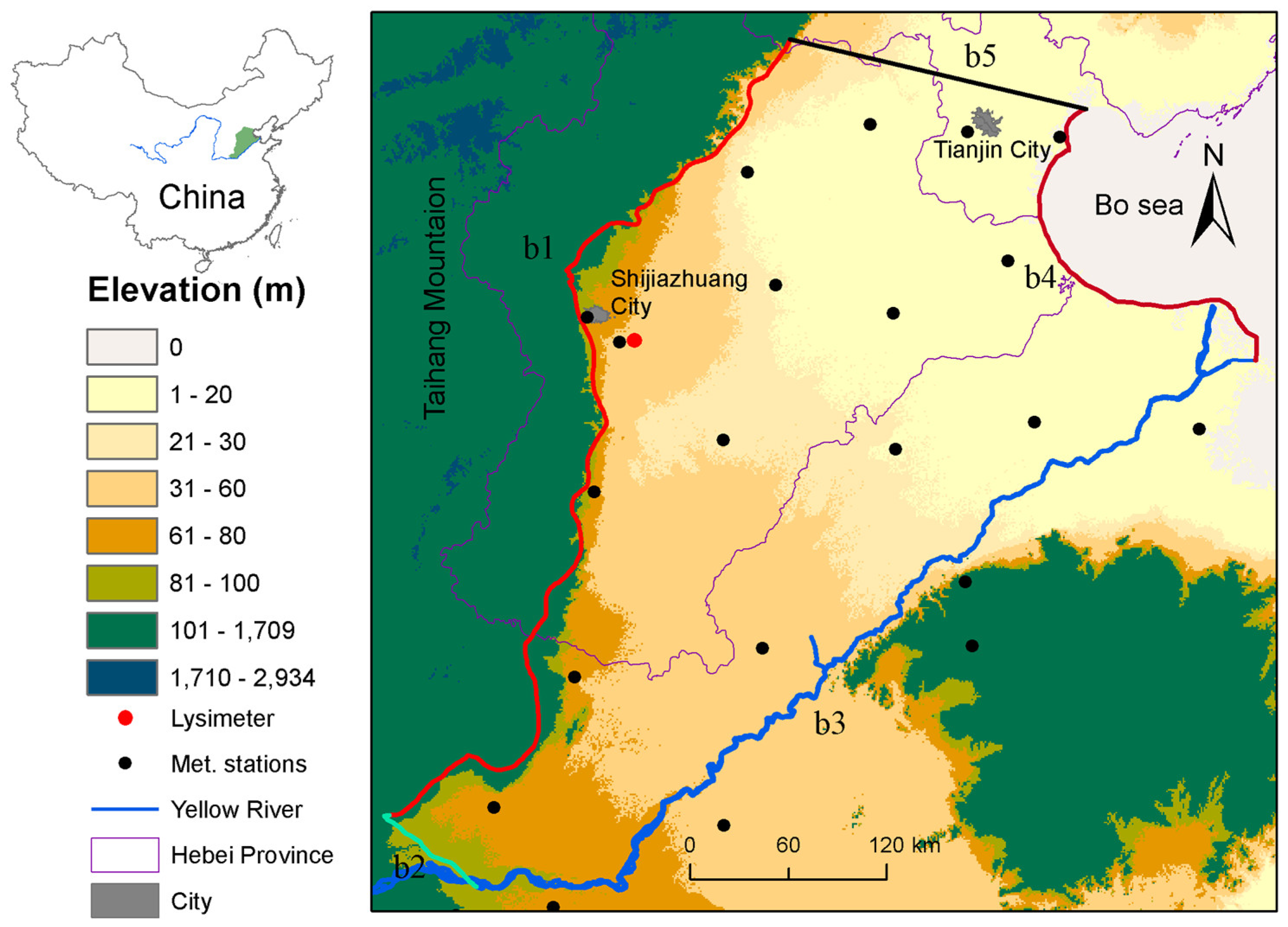
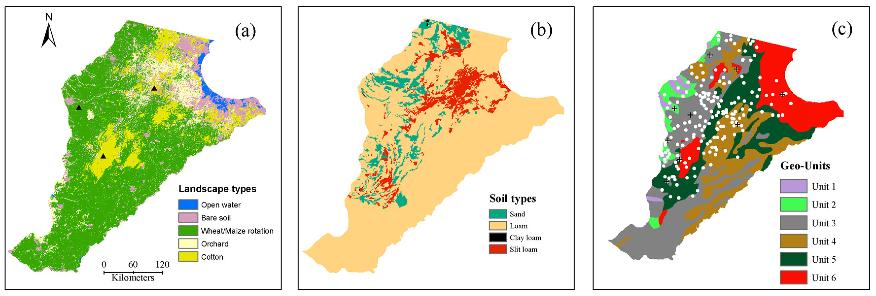
2.1. Study Area
2.2. Model Based on Conventional Data
2.2.1. MIKE SHE Model Code
2.2.2. Model Setup
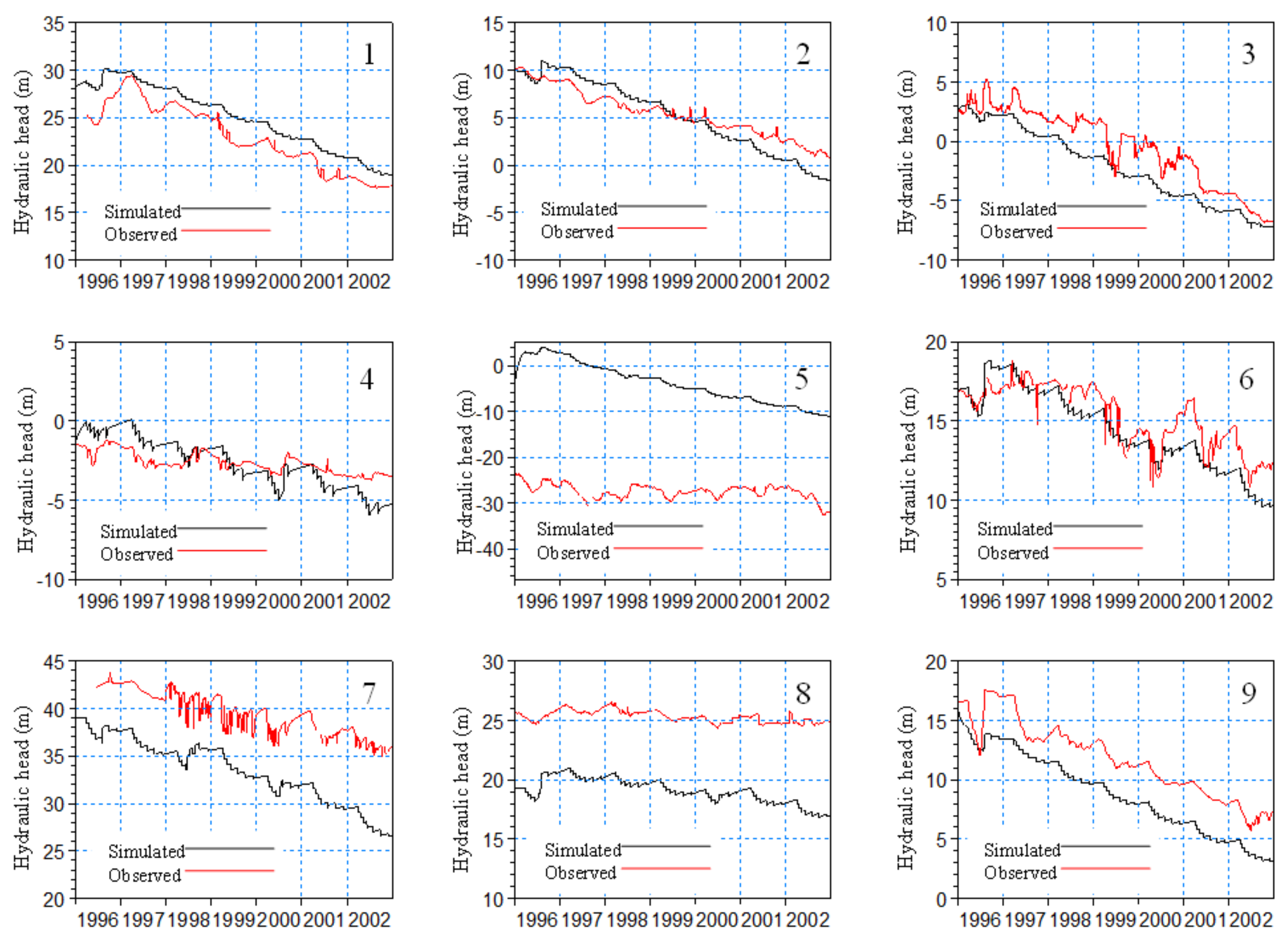
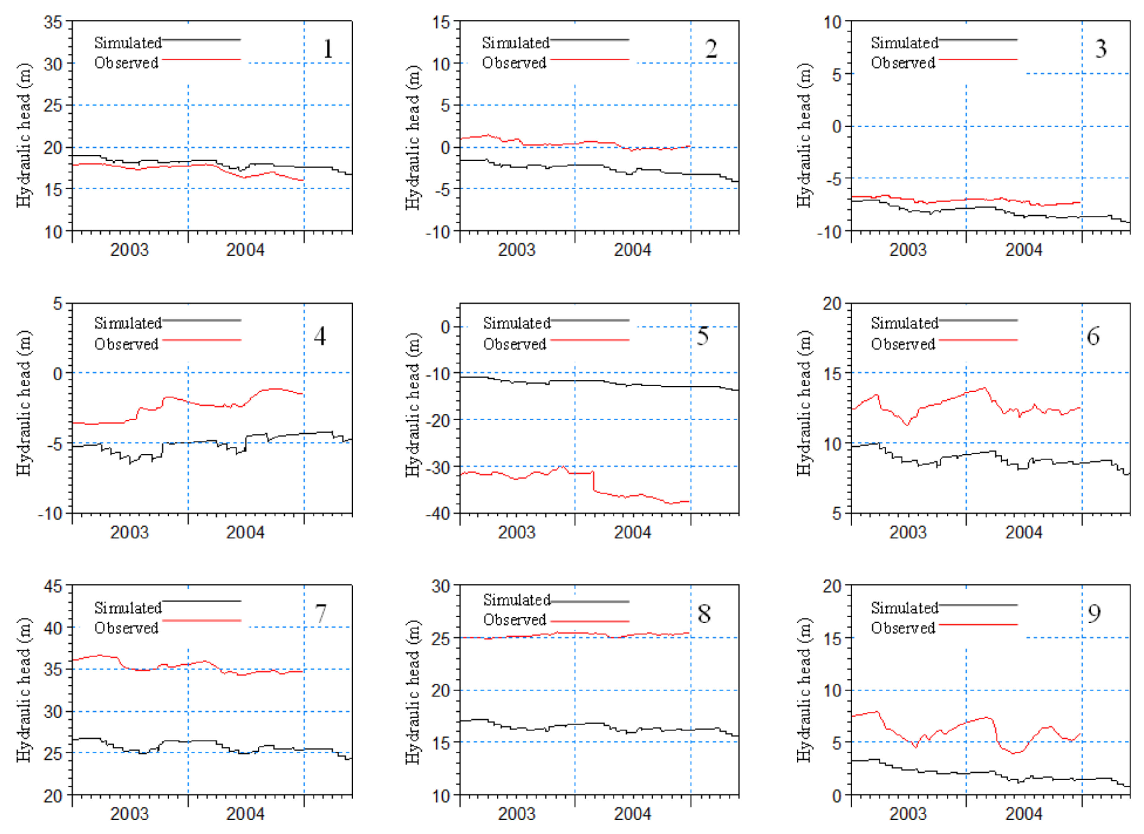
2.2.3. Model Calibration and Validation
2.3. Modelling Based on RS Data
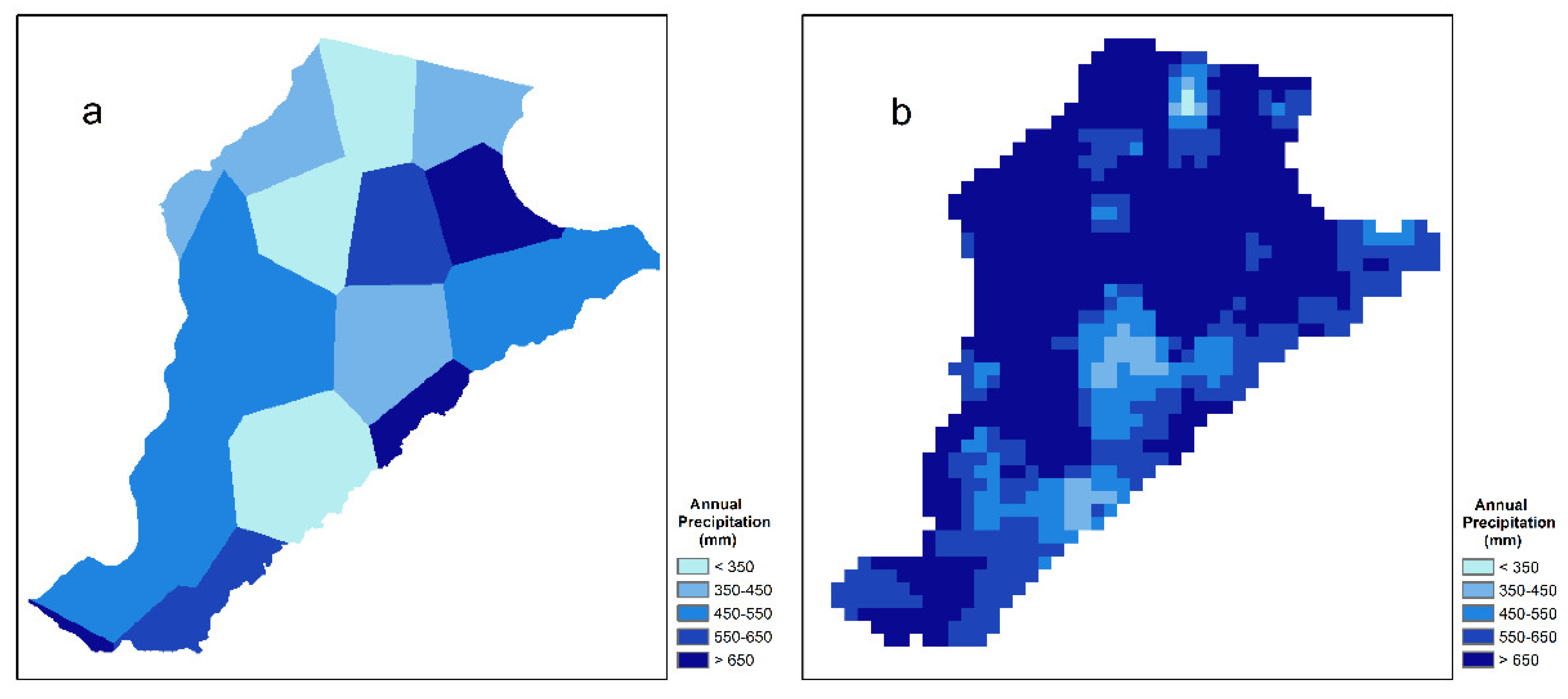
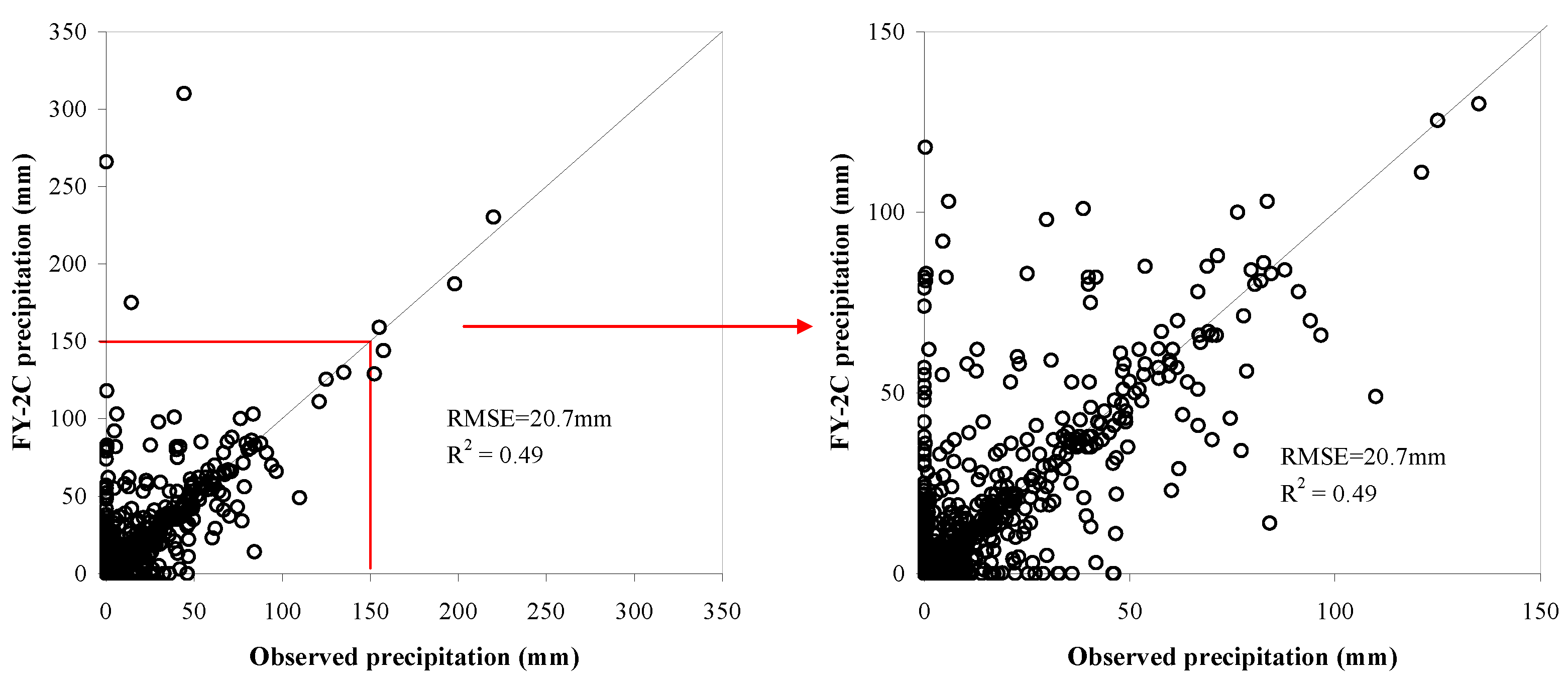
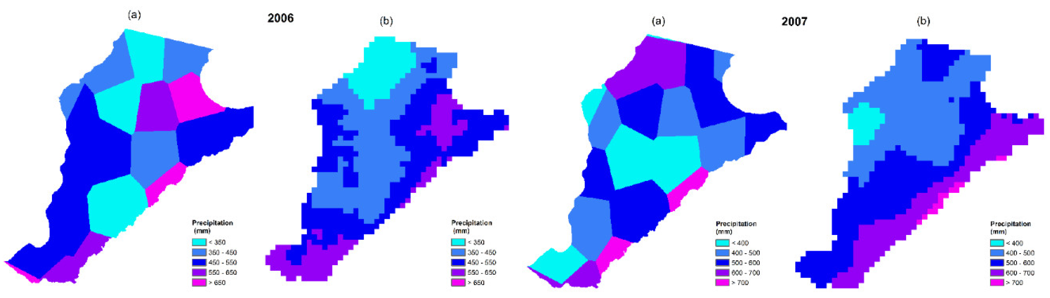
2.3.1. FY-2C Precipitation Products
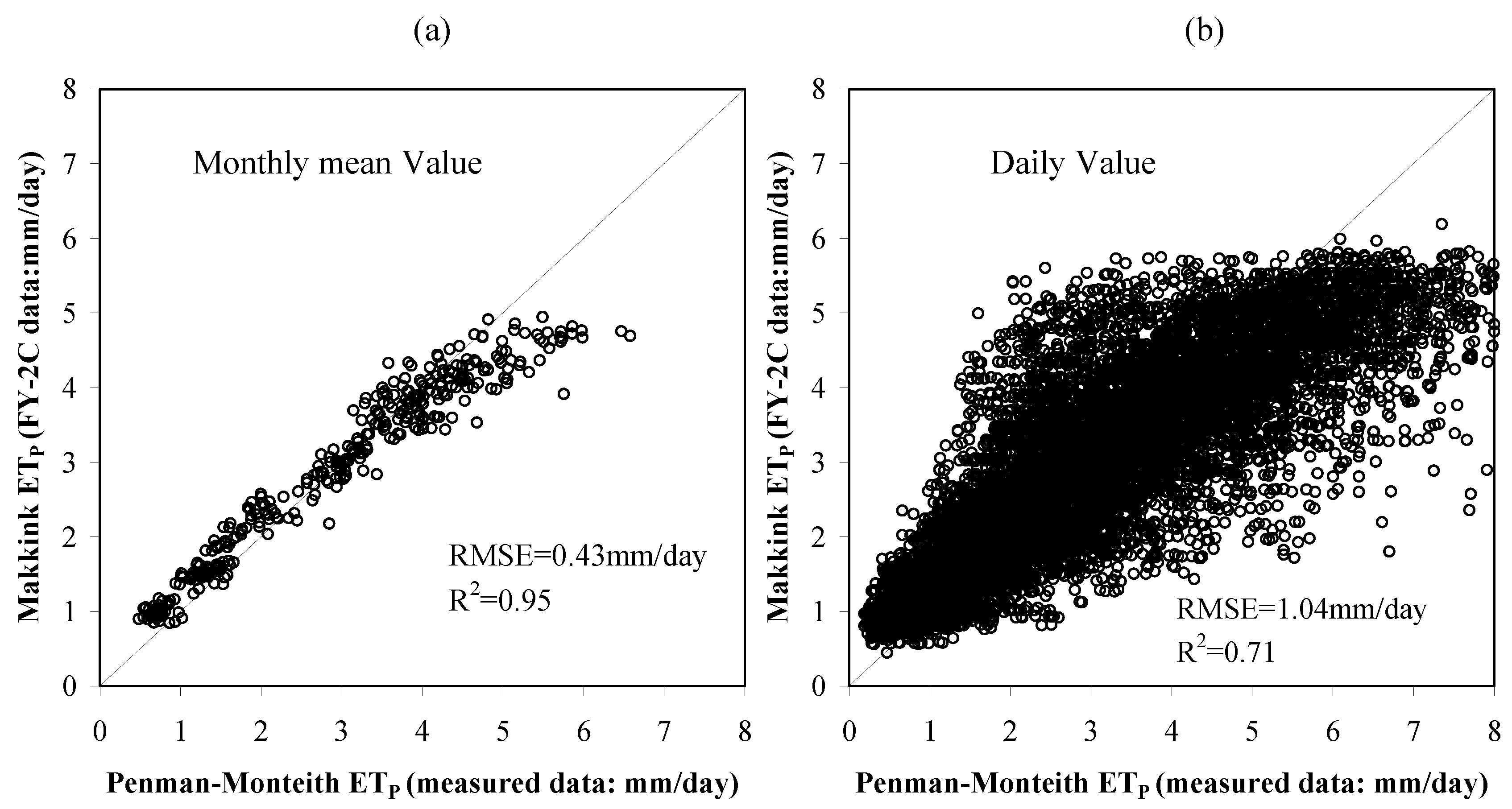
2.3.2. Potential Evapotranspiration
2.4. Comparison of Conventional and RS Models
3. Results
3.1. Total Water Balance Components
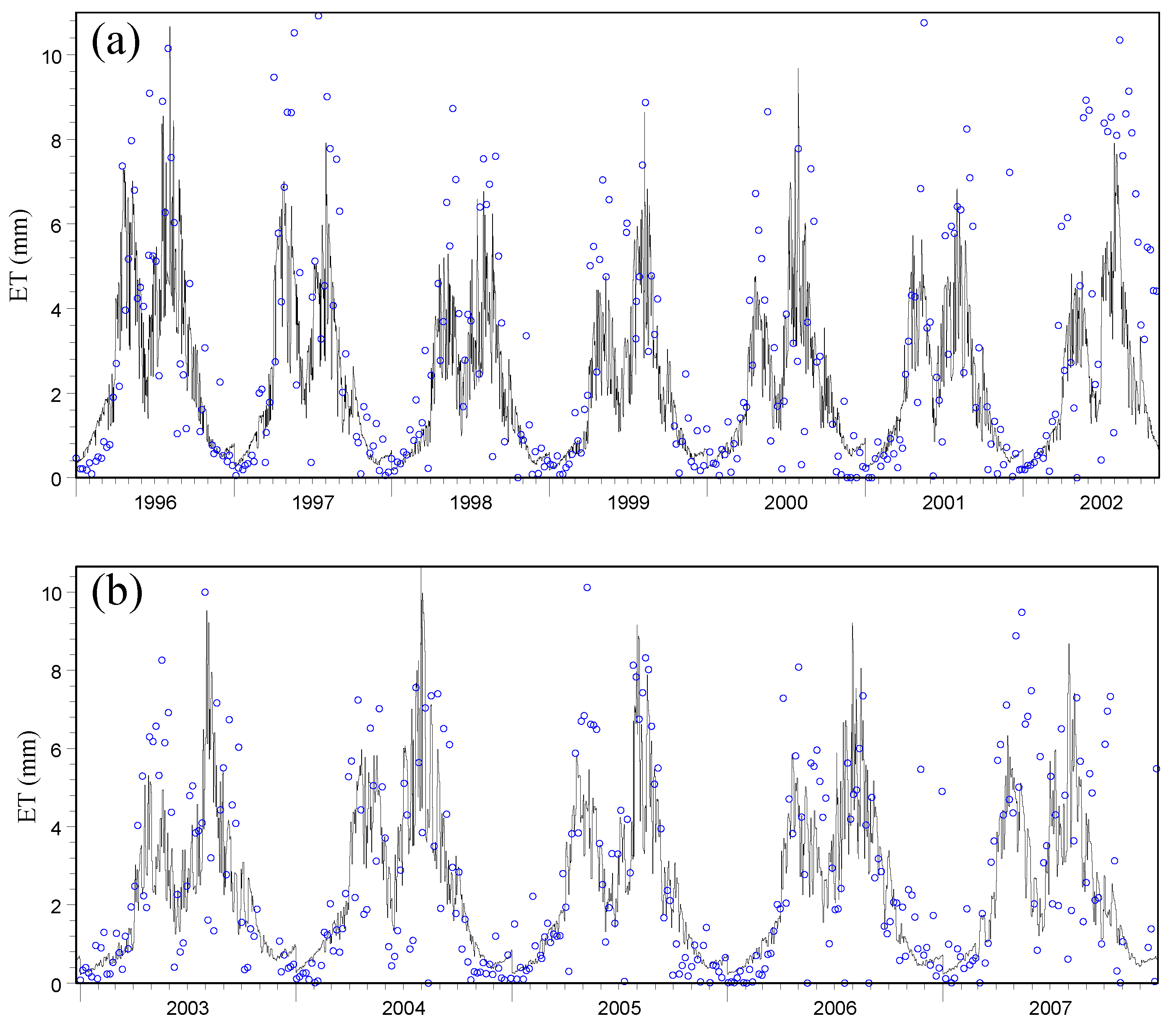
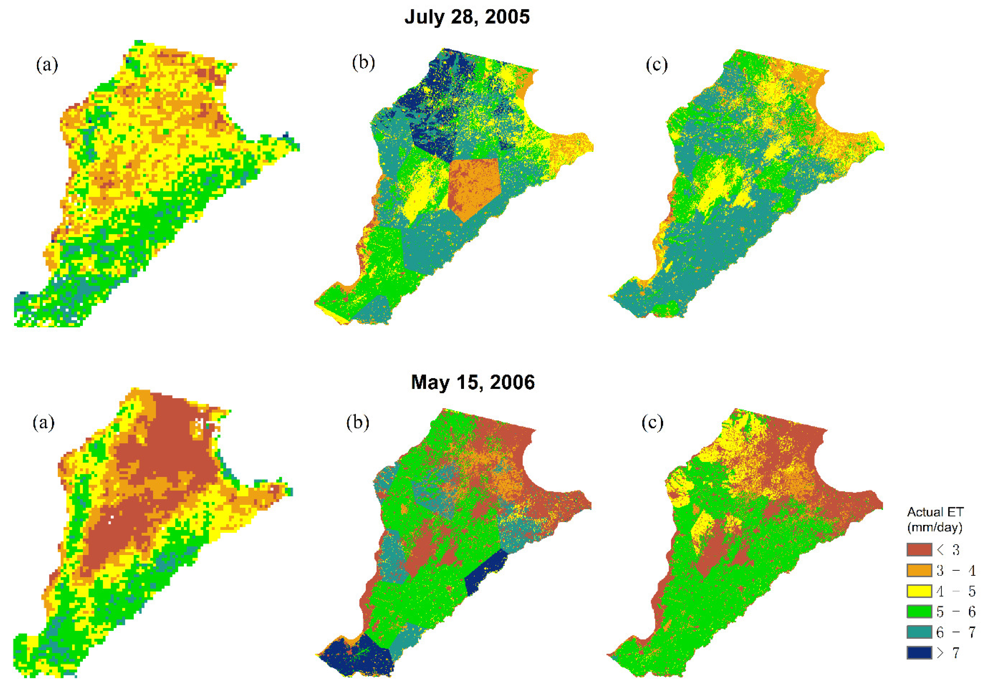
3.2. Actual ET
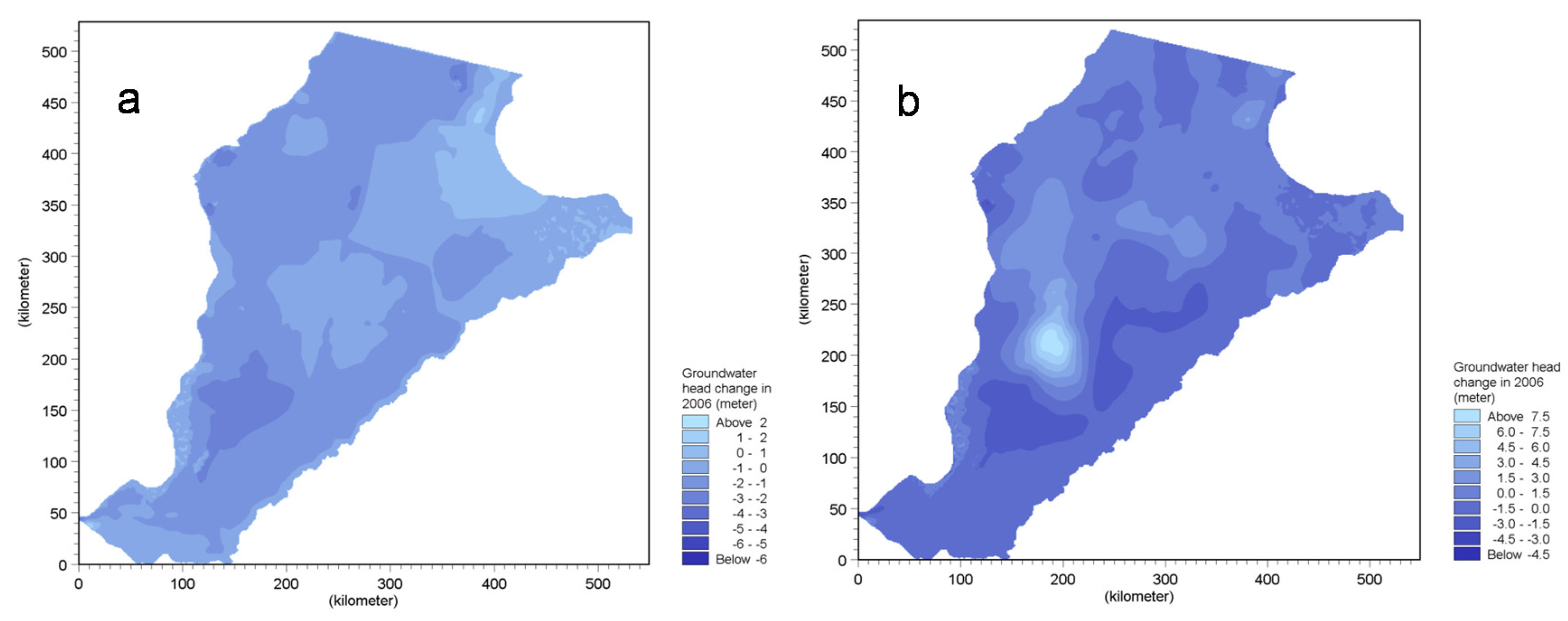
3.3. Groundwater Dynamic Change
4. Discussion
5. Conclusions
Author Contributions
Funding
Acknowledgments
Conflicts of Interest
References
- Kumar, S.; Sekhar, M.; Bandyopadhyay, S. Assimilation of remote sensing and hydrological data using adaptive filtering techniques for watershed modelling. Curr. Sci. 2009, 97, 1196–1202. [Google Scholar]
- Doppler, T.; Honti, M.; Zihlmann, U.; Weisskopf, P.; Stamm, C. Validating a spatially distributed hydrological model with soil morphology data. Hyorol. Earth Syst. Sci. 2014, 18, 3481–3498. [Google Scholar] [CrossRef]
- Frana, A.S. Applicability of Mike She to Simulate Hydrology in Heavily Tile Drained Agricultural Land and Effects of Drainage Characteristics on Hydrology. Master’s Thesis-ProQuest Dissertations & Theses Global, 2012. Available online: http://lib.dr.iastate.edu/cgi/viewcontent.cgi?article=3866& context =etd&httpsredir=1&article=3866&context=etd (accessed on 18 September 2018).
- Shu, Y.; Villholth, K.G.; Jensen, K.H.; Stisen, S.; Lei, Y. Integrated hydrological modeling of the North China plain: Options for sustainable groundwater use in the alluvial plain of MT. Taihang. J. Hydrol. 2012, 464–465, 79–93. [Google Scholar] [CrossRef]
- Stisen, S.; Jensen, K.H.; Sandholt, I.; Grimes, D.I.F. A remote sensing driven distributed hydrological model of the Senegal River basin. J. Hydrol. 2008, 354, 131–148. [Google Scholar] [CrossRef]
- Van Roosmalen, L.; Sonnenborg, T.O.; Jensen, K.H. Impact of climate and land use change on the hydrology of a large-scale agricultural catchment. Water Resour. Res. 2009, 45. [Google Scholar] [CrossRef] [Green Version]
- Qin, H.; Cao, G.; Kristensen, M.; Refsgaard, J.C.; Rasmussen, M.O.; He, X.; Liu, J.; Shu, Y.; Zheng, C. Integrated hydrological modeling of the North China plain and implications for sustainable water management. Hydrol. Earth Syst. Sci. 2013, 17, 3759–3778. [Google Scholar] [CrossRef] [Green Version]
- Beven, K. How far can we go in distributed hydrological modelling? Hydrol. Earth Syst. Sci. 1999, 5, 1–12. [Google Scholar] [CrossRef]
- Refsgaard, J.C. Parameterisation, calibration and validation of distributed hydrological models. J. Hydrol. 1997, 198, 69–97. [Google Scholar] [CrossRef]
- Fu, S.; Sonnenborg, T.O.; Jensen, K.H.; He, X. Impact of precipitation spatial resolution on the hydrological response of an integrated distributed water resources model. Vadose Zone J. 2011, 10, 25–36. [Google Scholar] [CrossRef]
- Bitew, M.M.; Gebremichael, M. Evaluation of satellite rainfall products through hydrologic simulation in a fully distributed hydrologic model. Water Resour. Res. 2011, 47. [Google Scholar] [CrossRef] [Green Version]
- Brunner, P.; Hendricks Franssen, H.J.; Kgotlhang, L.; Bauer-Gottwein, P.; Kinzelbach, W. How can remote sensing contribute in groundwater modeling? Hydrogeol. J. 2006, 15, 5–18. [Google Scholar] [CrossRef]
- Li, H.T.; Brunner, P.; Kinzelbach, W.; Li, W.P.; Dong, X.G. Calibration of a groundwater model using pattern information from remote sensing data. J. Hydrol. 2009, 377, 120–130. [Google Scholar] [CrossRef]
- Milzow, C.; Kgotlhang, L.; Kinzelbach, W.; Meier, P.; Bauer-Gottwein, P. The role of remote sensing in hydrological modelling of the Okavango Delta, Botswana. J. Environ. Manag. 2009, 90, 2252–2260. [Google Scholar] [CrossRef] [PubMed]
- Andersen, J.; Dybkjaer, G.; Jensen, K.H.; Refsgaard, J.C.; Rasmussen, K. Use of remotely sensed precipitation and leaf area index in a distributed hydrological model. J. Hydrol. 2002, 264, 7. [Google Scholar] [CrossRef]
- Fana Biftu, G.; Yew Gan, T. A semi-distributed, physics-based hydrologic model using remotely sensed and digital terrain elevation data for semi-arid catchments. Int. J. Remote Sens. 2004, 25, 4351–4379. [Google Scholar] [CrossRef]
- Diop, M.; Grimes, D.I.F. Satellite-based rainfall estimation for river flow forecasting in Africa. II: African easterly waves, convection and rainfall. Hydrol. Sci. J. 2003, 48, 585–599. [Google Scholar] [CrossRef]
- Boegh, E.; Thorsen, M.; Butts, M.B.; Hansen, S.; Christiansen, J.S.; Abrahamsen, P.; Hasager, C.B.; Jensen, N.O.; van der Keur, P.; Refsgaard, J.C.; et al. Incorporating remote sensing data in physically based distributed agro-hydrological modelling. J. Hydrol. 2004, 287, 279–299. [Google Scholar] [CrossRef]
- Simons, G.; Bastiaanssen, W.; Ngô, L.; Hain, C.; Anderson, M.; Senay, G. Integrating global satellite-derived data products as a pre-analysis for hydrological modelling studies: A case study for the red river basin. Remote Sens. 2016, 8, 279. [Google Scholar] [CrossRef]
- Campo, L.; Caparrini, F.; Castelli, F. Use of multi-platform, multi-temporal remote-sensing data for calibration of a distributed hydrological model: An application in the Arno Basin, Italy. Hydrol. Process. 2006, 20, 2693–2712. [Google Scholar] [CrossRef]
- Immerzeel, W.W.; Droogers, P. Calibration of a distributed hydrological model based on satellite evapotranspiration. J. Hydrol. 2008, 349, 411–424. [Google Scholar] [CrossRef]
- Zhang, Y.; Chiew, F.H.S.; Zhang, L.; Li, H. Use of remotely sensed actual evapotranspiration to improve rainfall–runoff modeling in Southeast Australia. J. Hydrometeorol. 2009, 10, 969–980. [Google Scholar] [CrossRef]
- Liu, J.; Zheng, C.M.; Zheng, L.; Lei, Y.P. Ground water sustainability: Methodology and application to the north china plain. Ground Water 2008, 46, 897–909. [Google Scholar] [CrossRef] [PubMed]
- Shen, H.; Leblanc, M.; Tweed, S.; Liu, W. Groundwater depletion in the Hai river basin, china, from in situ and grace observations. Hydrol. Sci. J. 2015, 60, 671–687. [Google Scholar] [CrossRef]
- Jiang, L.; Islam, S. Estimation of surface evaporation map over southern great plains using remote sensing data. Water Resour. Res. 2001, 37, 329–340. [Google Scholar] [CrossRef]
- Stisen, S.; Sandholt, I.; Nørgaard, A.; Fensholt, R.; Jensen, K.H. Combining the triangle method with thermal inertia to estimate regional evapotranspiration—Applied to msg-seviri data in the senegal river basin. Remote Sens. Environ. 2008, 112, 1242–1255. [Google Scholar] [CrossRef]
- Shu, Y.; Stisen, S.; Jensen, K.H.; Sandholt, I. Estimation of regional evapotranspiration over the North China plain using geostationary satellite data. Int. J. Appl. Earth Obs. Geoinf. 2011, 13, 192–206. [Google Scholar] [CrossRef]
- Moiwo, J.P.; Yang, Y.; Li, H.; Han, S.; Yang, Y. Impact of water resource exploitation on the hydrology and water storage in baiyangdian lake. Hydrol. Process. 2010, 24, 3026–3039. [Google Scholar] [CrossRef]
- Sun, R.; Jin, M.; Giordano, M.; Villholth, K.G. Urban and rural groundwater use in Zhengzhou, China: Challenges in joint management. Hydrogeol. J. 2009, 17, 1495–1506. [Google Scholar] [CrossRef]
- Yan, J.R.S. Keith Simulation of integrated surface water and ground water systems—Model formulation. J. Am. Water Resour. Assoc. 1994, 30, 12. [Google Scholar] [CrossRef]
- Allen, R.G.P.; Raes, D.; Smith, M. Crop Evapotranspiration—Guidelines for Computing Crop Water Requirements—Fao Irrigation and Drainage Paper 56; Food and Agriculture Organization of the United Nations: Rome, Italy, 1998; Available online: http://www.fao.org/docrep/X0490E/x0490e00.htm (accessed on 18 September 2018).
- Xu, J.M. Manual for Fengyun-2 Satellite Products and Satellite Data Format; China Meteorology Press: Beijing, China, 2008. (In Chinese) [Google Scholar]
- CMA. China Meteorological Administration Report on Precipitation Products; the Coordination Group for Meteorological Satellites, China Meteorological Administration, China. 2010. Available online: http://www.eumetsat.int/website/wcm/idc/idcplg?IdcService=GET_FILE&RevisionSelectionMethod=LatestReleased&Rendition=Web&dDocName=CWPT_1539 (accessed on 18 September 2018).
- Cheng, L. Assessment Study of Merged Precipitation and Multiple Satellite Precipitation Products. Master’s Thesis, College of Remote Sensing, Nanjing University of Information Engineering, Nanjing, China, 2013. [Google Scholar]
- Jia, J.; Yu, J.; Liu, C. Groundwater Regime and Calculation of Yield Response in North China Plain: A Case Study of Luancheng County in Hebei Province. J. Geogr. Sci. 2002, 12, 217–225. [Google Scholar]
- Wang, S.; Song, X.; Wang, Q.; Xiao, G.; Liu, C.; Liu, J. Shallow groundwater dynamics in North China plain. J. Geogr. Sci. 2009, 19, 175–188. [Google Scholar] [CrossRef]
- Doherty, J. Pest-Asp User’s Mannual; Scientific Software Group: Provo, UT, USA, 2001. [Google Scholar]
- National Satellite Meteorological Centre. FY-2C Products User Guide; China Meteorological Data Service Center: Beijing, China, 2008. (In Chinese) [Google Scholar]
- Makkink, G.F. Testing the penman formula by means of lysimeters. J. Inst. Water Eng. 1957, 11, 277–288. [Google Scholar]
- Liang, S.; Townshend, J.R. A modified hapke model for soil bidirectional reflectance. Remote Sens. Environ. 1996, 55, 181–189. [Google Scholar] [CrossRef]
- Liang, S.; Lewis, P. A parametric radiative transfer model for sky radiance distribution. J. Quant. Spectrosc. Radiat. Transf. 1996, 55, 9. [Google Scholar] [CrossRef]
- Boegh, E.; Soegaard, H. Remote sensing based estimation of evapotranspiration rates. Int. J. Remote Sens. 2004, 25, 2535–2551. [Google Scholar]
- Wang, S.; Song, X.; Wang, Q.; Xiao, G.; Wang, Z.; Liu, X.; Wang, P. Shallow groundwater dynamics and origin of salinity at two sites in salinated and water-deficient region of North China plain, China. Environ. Earth Sci. 2012, 66, 729–739. [Google Scholar]


| Date Type | Date Resource | Spatial Discretisation |
|---|---|---|
| Distributed maps | ||
| Topography/DEM | SRTM 90 m Digital Elevation Data (http://srtm.csi.cgiar.org/) | 90 × 90 m |
| Landscape (vegetation) | MODIS NDVI based classification | 250 × 250 m |
| Soil types | Soil map of Hebei province | |
| Precipitation zones | Stations distributed by Thiessens Polygon Method | 23 points |
| Potential evapotranspiration zones | Stations distributed by Thiessens Polygon Method | 23 points |
| Initial groundwater head | Interpolation from observed groundwater heads | 200 heads |
| Bottom elevation of the aquifer system | Hebei Geological map | 1:500,000 |
| Geological units | Huanghuaihai Plain geology map | |
| RS precipitation products | FY-2C products | 0.1° × 0.1° |
| RS potential evapotranspiration | FY-2C products | 1° × 1 ° |
| Time series | ||
| Precipitation | National meteorological stations | |
| Potential evapotranspiration | National meteorological stations | |
| LAI | Measured or from reference | |
| Kc | Measured or from reference | |
| Root depth | Measured or from reference |
| Soil Type | θsat | θfc | θwp | Ks (m/s) |
|---|---|---|---|---|
| Loam | 0.47 | 0.386 | 0.102 | 5.2 × 10⁻⁶ |
| Sandy | 0.43 | 0.1 | 0.05 | 1 × 10⁻³ |
| Sandy loam | 0.41 | 0.35 | 0.07 | 8 × 10⁻⁶ |
| Clay loam | 0.42 | 0.39 | 0.14 | 3.5 × 10⁻⁸ |
| Parameters * | Initial Value | Parameter Ties | Lower Bound | Upper Bound | Final Value |
|---|---|---|---|---|---|
| K1 (m/s) | 0.004 | tied to K2 | 1.00 × 10⁻¹⁰ | 1.00 × 10¹⁰ | 0.0037 |
| Sy1 | 0.25 | tied to Sy2 | 1.00 × 10⁻¹⁰ | 1.00 × 10¹⁰ | 0.266 |
| K2 (m/s) | 0.002 | 1.00 × 10⁻¹⁰ | 1.00 × 10¹⁰ | 0.0018 | |
| Sy2 | 0.2 | 1.00 × 10⁻¹⁰ | 1.00 × 10¹⁰ | 0.212 | |
| K3 (m/s) | 0.001 | tied to K4 | 1.00 × 10⁻¹⁰ | 1.00 × 10¹⁰ | 0.0010 |
| Sy3 | 0.153 | tied to Sy4 | 1.00 × 10⁻¹⁰ | 1.00 × 10¹⁰ | 0.20 |
| K4 (m/s) | 0.001 | 1.00 × 10⁻¹⁰ | 1.00 × 10¹⁰ | 0.0010 | |
| Sy4 | 0.15 | 1.00 × 10⁻¹⁰ | 1.00 × 10¹⁰ | 0.196 | |
| K5 (m/s) | 0.0005 | tied to K6 | 1.00 × 10⁻¹⁰ | 1.00 × 10¹⁰ | 0.0006 |
| Sy5 | 0.1 | tied to Sy6 | 1.00 × 10⁻¹⁰ | 1.00 × 10¹⁰ | 0.135 |
| K6 (m/s) | 0.0002 | 1.00 × 10⁻¹⁰ | 1.00 × 10¹⁰ | 0.0002 | |
| Sy6 | 0.08 | 1.00 × 10⁻¹⁰ | 1.00 × 10¹⁰ | 0.108 | |
| b1 | 0.0015 | 1.00 × 10⁻¹⁰ | 1.00 × 10¹⁰ | 0.0010 | |
| b2 | 0.0015 | 1.00 × 10⁻¹⁰ | 1.00 × 10¹⁰ | 0.0012 |
| Statistic | Daily | 5-Day | ||||
|---|---|---|---|---|---|---|
| RMSE | dherror | ab(dherror) | RMSE | dherror | ab(dherror) | |
| Max | 19.77 | 15.67 | 15.67 | 36.01 | 11.31 | 15.02 |
| Min | 0.79 | −6.76 | 0.01 | 0.57 | −15.02 | 0.02 |
| Mean | 6.21 | 0.08 | 3.63 | 8.92 | 0.06 | 3.28 |
| σ | 4.87 | 4.98 | 3.41 | 7.16 | 4.23 | 2.67 |
| Water Balance Components | 2006 | 2007 | ||
|---|---|---|---|---|
| Conventional Model | RS Model | Conventional Model | RS Model | |
| Precipitation | 456 | 742 | 524 | 533 |
| Actual evapotranspiration | 673 | 769 | 698 | 726 |
| Unsaturated zone storage change | −7 | −22 | 27 | 19 |
| Saturated zone storage change | −193 | 12 | −182 | −193 |
| Pumping for irrigation | 271 | 271 | 270 | 271 |
| Pumping for industry and domestic use | 5 | 5 | 5 | 5 |
| Groundwater recharge | 64 | 269 | 71 | 60 |
| Lateral inflow | 25 | 25 | 27 | 27 |
| Lateral outflow | 1 | 1 | 1 | 4 |
© 2018 by the authors. Licensee MDPI, Basel, Switzerland. This article is an open access article distributed under the terms and conditions of the Creative Commons Attribution (CC BY) license (http://creativecommons.org/licenses/by/4.0/).
Share and Cite
Shu, Y.; Li, H.; Lei, Y. Modelling Groundwater Flow with MIKE SHE Using Conventional Climate Data and Satellite Data as Model Forcing in Haihe Plain, China. Water 2018, 10, 1295. https://doi.org/10.3390/w10101295
Shu Y, Li H, Lei Y. Modelling Groundwater Flow with MIKE SHE Using Conventional Climate Data and Satellite Data as Model Forcing in Haihe Plain, China. Water. 2018; 10(10):1295. https://doi.org/10.3390/w10101295
Chicago/Turabian StyleShu, Yunqiao, Hongjun Li, and Yuping Lei. 2018. "Modelling Groundwater Flow with MIKE SHE Using Conventional Climate Data and Satellite Data as Model Forcing in Haihe Plain, China" Water 10, no. 10: 1295. https://doi.org/10.3390/w10101295