Mapping the Gap of Water and Erosion Control Measures in the Rapidly Urbanizing Mbezi River Catchment of Dar es Salaam

 ,
,
Abstract
1. Introduction
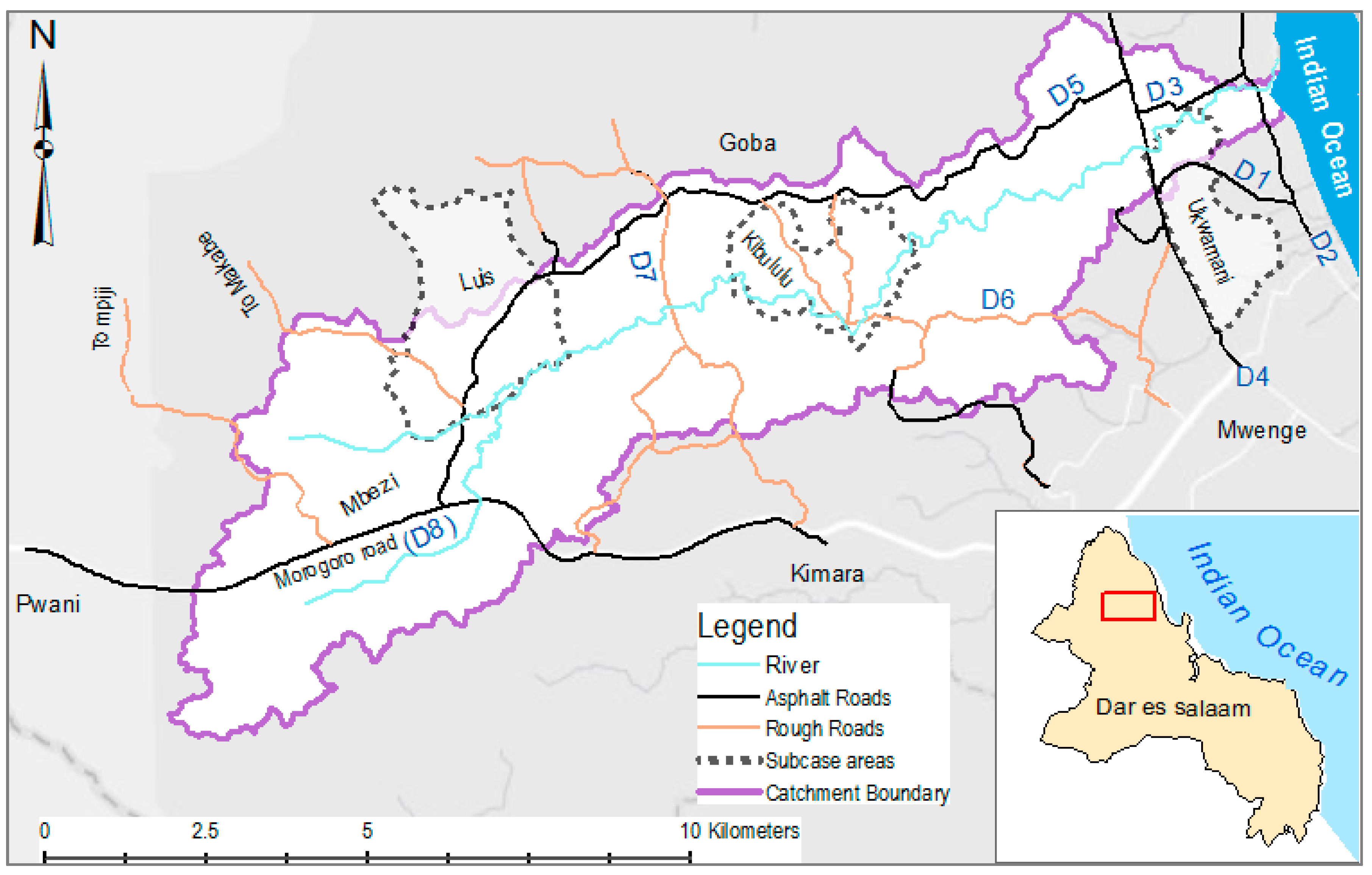
2. Materials and Methods
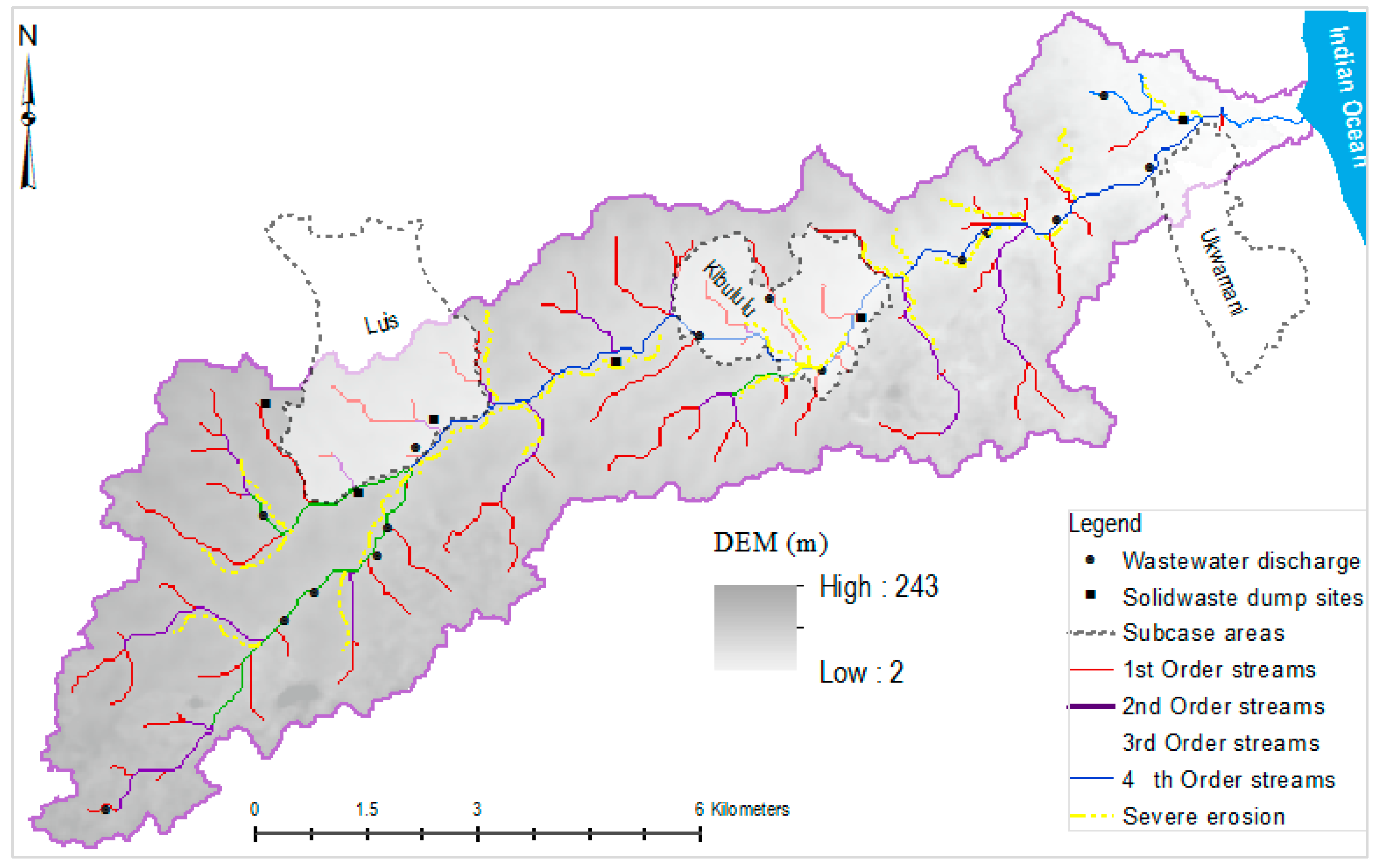
3. Results
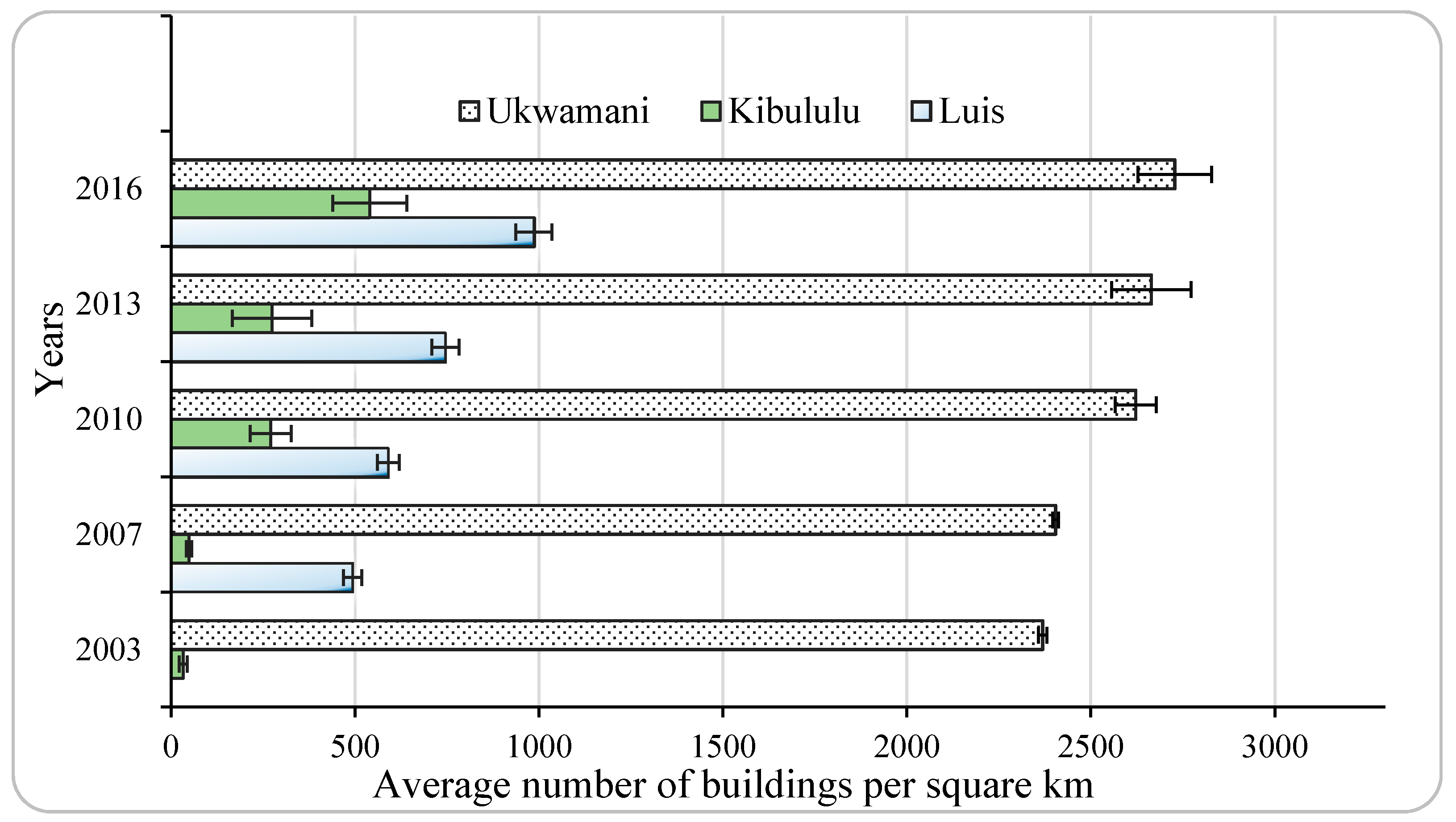
3.1. Urbanization Trends and Water Related Challenges
3.2. Stormwater Infrastructures on Private and Public Initiative
3.3. Challenges and Solutions According to Officials
4. Discussion
5. Conclusions
Acknowledgments
Author Contributions
Conflicts of Interest
References
- Shaver, E.; Horner, R.; Skupien, J.; May, C.; Ridle, G. Fundamentals of Urban Runoff Management (Technical and Institutional Issues); North American Lake Management Society: Madison, MI, USA, 2007. [Google Scholar]
- Giacomoni, M.; Gomez, R.; Berglund, E.Z. Hydrologic Impact Assessment of Land Cover Change and Stormwater Management Using the Hydrologic Footprint Residence. J. Am. Water Resour. Assoc. 2014, 50, 1242–1256. [Google Scholar] [CrossRef]
- Schumann, A.H.; Funke, R.; Schultz, G.A. Application of a geographic information system for conceptual rainfall–runoff modeling. J. Hydrol. 2000, 240, 45–61. [Google Scholar] [CrossRef]
- Bernhardt, E.S.; Palmer, M.A. Restoring streams in an urbanizing world. Freshw. Biol. 2007, 52, 738–751. [Google Scholar] [CrossRef]
- Bülent, C. Urban River Landscapes. In Advances in Landscape Architecture; In Tech: London, UK, 2013. [Google Scholar]
- Burns, M.J.; Fletcher, T.D.; Walsh, C.J.; Ladson, A.R.; Hatt, B.E. Hydrologic shortcomings of conventional urban stormwater management and opportunities for reform. Landsc. Urban Plan. 2012, 105, 230–240. [Google Scholar] [CrossRef]
- Duh, J.-D.; Shandas, V.; Chang, H.; George, L.A. Rates of urbanisation and the resiliency of air and water quality. Sci. Total Environ. 2008, 400, 238–256. [Google Scholar] [CrossRef] [PubMed]
- Vörösmarty, C.J.; McIntyre, P.B.; Gessner, M.O.; Dudgeon, D.; Prusevich, A.; Green, P.; Glidden, S.; Bunn, S.E.; Sullivan, C.A.; Liermann, C.R.; Davies, P.M. Global threats to human water security and river biodiversity. Nature 2010, 467, 555–561. [Google Scholar] [CrossRef] [PubMed]
- Violin, C.R.; Cada, P.; Sudduth, E.B.; Hassett, B.A.; Penrose, D.L.; Bernhardt, E.S. Effects of urbanization and urban stream restoration on the physical and biological structure of stream ecosystems. Ecol. Appl. 2011, 21, 1932–1949. [Google Scholar] [CrossRef] [PubMed]
- Konrad, C.P.; Booth, D.K. Hydrologic Changes in Urban Streams and Their Ecological Significance. Am. Fish. Soc. Symp. 2005, 47, 157–177. [Google Scholar]
- Walsh, C.J.; Roy, A.H.; Feminella, J.W.; Cottingham, P.D.; Groffman, P.M.; Morgan, R.P., II. The urban stream syndrome: Current knowledge and the search for a cure. J. N. Am. Benthol. Soc. 2005, 24, 706–723. [Google Scholar] [CrossRef]
- Yeh, A.G.-O.; Li, X. Measurement and monitoring of urban sprawl in a rapidly growing region using entropy. Photogramm. Eng. Remote Sens. 2001, 67, 83–90. [Google Scholar]
- Ujoh, F.; kwabe, I.D.; Ifatimehin, O.O. Understanding urban sprawl in the Federal Capital City, Abuja: Towards sustainable urbanization in Nigeria. J.Geogr. Reg. Plan. 2010, 3, 106–113. [Google Scholar]
- White, M.J.; Mberu, B.U.; Collinson, M.A. African urbanization: Recent trends and implications. In The New Global Frontier: Urbanization, Poverty and Environment in the 21 Century; Earthscan: London, UK, 2008. [Google Scholar]
- Kithakye, D.; Mutashubirwa, P.; Kayani, L. Tanzania: Dar es Salaam City Profile; United Nations Human Settlements Programme: Nairobi, Kenya, 2009; pp. 8–23. [Google Scholar]
- Briggs, J.; Mwamfupe, D. Peri-urban development in an era of structural adjustment in Africa: The city of Dar es Salaam, Tanzania. Urban Stud. 2000, 37, 797–809. [Google Scholar] [CrossRef]
- Kebede, A.S.; Nicholls, R.J. Exposure and vulnerability to climate extremes: Population and asset exposure to coastal flooding in Dar es Salaam, Tanzania. Reg. Environ. Chang. 2012, 12, 81–94. [Google Scholar] [CrossRef]
- Kiunsi, R. The constraints on climate change adaptation in a city with a large development deficit: The case of Dar es Salaam. Environ. Urban. 2013, 25, 321–337. [Google Scholar] [CrossRef]
- Kjellén, M. From Public Pipes to Private Hands: Water Access and Distribution in Dar es Salaam, Tanzania. Ph.D. Thesis, Stockholm University, Stockholm, Sweden, 2006. [Google Scholar]
- Kyessi, A.G. Community-based urban water management in fringe neighbourhoods: The case of Dar es Salaam, Tanzania. Habitat Int. 2005, 29, 1–25. [Google Scholar] [CrossRef]
- Sakijege, T.; Lupala, J.; Sheuya, S. Flooding, flood risks and coping strategies in urban informal residential areas: The case of Keko Machungwa, Dar es Salaam, Tanzania. Jamba J. Disaster Risk Stud. 2012, 4. [Google Scholar] [CrossRef]
- Mbuligwe, S.E.; Kaseva, M.E. Pollution and self-cleansing of an urban river in a developing country: A case study in Dar es Salaam, Tanzania. Environ. Manag. 2005, 36, 328–342. [Google Scholar] [CrossRef] [PubMed]
- Mbuya, E. Solid Waste Management in Dar es Salaam: Privatizing and Improving Revenue Collection. International Ocean Institute USA, 2008(141601). Available online: http://www.ioiusa.net/view/article/141601/ (accessed on 30 November 2017).
- McDonald, R.I.; Webera, K.; Padowskib, J.; Flörkec, M.; Schneiderc, C.; Greend, P.A.; Gleesone, T.; Eckmanf, S.; Lehnerg, B.; Balk, D.; et al. Water on an urban planet: Urbanization and the reach of urban water infrastructure. Glob. Environ. Chang. 2014, 27, 96–105. [Google Scholar] [CrossRef]
- Hering, D.; Borja, A.; Carstensen, J.; Carvalho, L.; Elliott, M.; Feld, C.K.; Heiskanen, A.-S.; Johnson, R.K.; Moe, J.; Pont, D.; et al. The European Water Framework Directive at the age of 10: A critical review of the achievements with recommendations for the future. Sci. Total Environ. 2010, 408, 4007–4019. [Google Scholar] [CrossRef] [PubMed]
- Fisher-Jeffes, L.; Armitage, N. Charging for stormwater in South Africa. Water SA 2013, 39, 429–436. [Google Scholar] [CrossRef]
- Marsalek, J.; Chocat, B. International report: Stormwater management. Water Sci. Technol. 2002, 46, 1–17. [Google Scholar] [PubMed]
- Burns, M.J.; Fletcher, T.; Duncan, H.P.; Hatt, B.E.; Ladson, A.R.; Walsh, C.J. A/PROF Chris Walsh, The performance of rainwater tanks for stormwater retention and water supply at the household scale: An empirical study. Hydrol. Process. 2015, 29, 152–160. [Google Scholar] [CrossRef]
- Fletcher, T.D.; Shuster, W.; Hunt, W.F.; Ashley, R.; Butler, D.; Arthur, S.; Trowsdale, S.; Barraud, S.; Semadeni-Davies, A.; Bertrand-Krajewski, J.-L.; et al. SUDS, LID, BMPs, WSUD and more–The evolution and application of terminology surrounding urban drainage. Urban Water J. 2015, 12, 525–542. [Google Scholar] [CrossRef]
- Maksimović, C.; Kurian, M.; Ardakanian, R. Rethinking Infrastructure Design for Multi-Use Water Services; Springer: Cham, Switzerland, 2015. [Google Scholar]
- Hamel, P.; Daly, E.; Fletcher, T.D. Source-control stormwater management for mitigating the impacts of urbanisation on baseflow: A review. J. Hydrol. 2013, 485, 201–211. [Google Scholar] [CrossRef]
- Engineers Australia. Australian Runoff Quality: A Guide to Water Sensitive Urban Design; Engineers Media for Australian Runoff Quality Authorship Team: Sydney, Australia, 2006. [Google Scholar]
- Backhaus, A.; Dam, T.; Jensen, M.B. Stormwater management challenges as revealed through a design experiment with professional landscape architects. Urban Water J. 2012, 9, 29–43. [Google Scholar] [CrossRef]
- Ministry of Housing and Urban-Rural Development (MOHURD). China’s Sponge Cities Program: Soaking up Water to Reduce Flood Risks. 2014. Available online: https://www.theguardian.com/sustainable-business/2015/oct/01/china-sponge-cities-los-angeles-water-urban-design-drought-floods-urbanisation-rooftop-gardens (accessed on 1 December 2016).
- Mguni, P.; Herslund, L.; Jensen, M.B. Sustainable urban drainage systems: Examining the potential for green infrastructure-based stormwater management for Sub-Saharan cities. Nat. Hazards 2016, 82, 241–257. [Google Scholar] [CrossRef]
- Thomas, B.; David, C. A hydrologic screening method for storm water assessments based on a geometric network. Unpublished work.
- Mato, R.R.A.M. Groundwater Pollution in Urban Dar es Salaam, Tanzania Assessing Vulnerability and Protection Priorities; Eindhoven University of Technology: Eindhoven, The Netherlands, 2002; Available online: https://pure.tue.nl/ws/files/2386306/200211708.pdf (accessed on 30 November 2017).
- Mjemah, I. Hydrogeological and Hydrogeochemical Investigation of a Coastal Aquifer in Dar es Salaam, Tanzania. Ph.D. Thesis, Department of Geology and Soil Science Ghent University, Ghent, Belgium, 2007. [Google Scholar]
- Mjemah, I.C.; Walraevens, K. Hydrogeological mapping and estimation of potential evapotranspiration and recharge rate of Quaternary sand aquifers in Dar-es-Salaam, Tanzania. Int J. Geomat. Geosci. 2015, 6, 1539–1555. [Google Scholar]
- Malya, E.; Mwaijumba, S. Needs and Potentials of Rainwater Harvesting in Mbezi River Catchment. Master’s Thesis, Ardhi University, Dar es Salaam, Tanzania, 2016. [Google Scholar]
- Mbuligwe, S. Physical Infrastructure Service and Environmental Health Deficiencies in Urban and Peri-Urban Areas. In Encyclopedia of Environmental Health; Elsevier: Burlington, VT, USA, 2011. [Google Scholar]
- Strahler, A.N. Quantitative analysis of watershed geomorphology. Earth Space Sci. News 1957, 38, 913–920. [Google Scholar] [CrossRef]
- Barbosa, A.; Fernandes, J.; David, L. Key issues for sustainable urban stormwater management. Water Res. 2012, 46, 6787–6798. [Google Scholar] [CrossRef] [PubMed]
- Victorian Stormwater Committee. Urban Stormwater: Best-Practice Environmental Management Guidelines; CSIRO Publishing: Melbourne, Australia, 1999. [Google Scholar]
- Jain, M.K.; Singh, V.P. DEM-based modelling of surface runoff using diffusion wave equation. J. Hydrol. 2005, 302, 107–126. [Google Scholar] [CrossRef]
- Xu, Z.; Ito, K.; Schultz, G.A.; Li, J.Y. Integrated hydrologic modeling and GIS in water resources management. J. Comput. Civ. Eng. 2001, 15, 217–223. [Google Scholar]
- Debo, T.N.; Reese, A. Municipal Stormwater Management; CRC Press: Boca Raton, FL, USA, 2003. [Google Scholar]
- Butler, D.; Davies, J. Urban Drainage; CRC Press: Boca Raton, FL, USA, 2004. [Google Scholar]
- Wong, T.; Brown, R. The water sensitive city: Principles for practice. Water Sci. Technol. 2009, 60, 673–682. [Google Scholar] [CrossRef] [PubMed]
- Freni, G.; Mannina, G.; Viviani, G. Urban storm-water quality management: Centralized versus source control. J. Water Resour. Plan. Manag. 2010, 136, 268–278. [Google Scholar] [CrossRef]


| Assessment Criteria | Criteria Description and Main Features |
|---|---|
| Service coverage | Spatial extent and land area coverage of the service |
| Service level | Accessibility/availability degree and convenience of service to users |
| Effectiveness | Degree of achievement of service design goal |
| Condition of repair | Physical condition/capacity of service quality, service advancement level |
| Service standard | Status/hierarchy/level/class of service quality; service advancement level |
| Control Method Used | Appearance | Application Level | Intended Use/Functions | Drawback or Challenges According to Interviewees |
|---|---|---|---|---|
| Terracing with vetiver grass (Vetiveria zizanoides) and elephant grass (Pennisetum purpureum) |  | Plot level | Erosion reduction Fodder crop for dairy farmers (elephant grass) | Wilting due to long dry season
Takes long to establish |
| Sand bag barrier |  | Plot and neighbourhood level | Bank erosion control and | Temporary solution (lasts for two seasons at most) |
| Tree hedging |  | Plot and neighbourhood level | Erosion control and scenic improvement | Wilting due to long dry season |
| Used car tires barrier |  | Plot level | Erosion control | Short-term solution and space consuming |
| Dykes along the water courses |  | Tributary level | Protection against fluvial flooding and erosion control | Expensive to build and maintain; design and construction require expertise
Risk of transferring problems to neighbours |
| Drainage ditches |  | Plot and neighbourhood level | Protection against pluvial flooding | High construction cost; needs sufficient space and expertise to construct |
| Gabions and concrete retention walls |  | Tributary level | Control of bank erosion and protection against minor floods | Expensive and needsexpertise to install |
| Roof top runoff harvesting |  | Building level | Water supply and erosion control | High installation cost (vessels, pipes, expertise); rapid deterioration of water quality; long-term storage requires disinfectants |
| Runoff harvesting in ponds |  | Tributary level | Water supply | Requires large land; and expensive to maintain; needs expertise and permits |
| ID | Dimensions (m) | Appearance | Observation/Condition of Repair of the Drainage Channels |
|---|---|---|---|
| D1 | S = 1.3
L = 176.1 |  | Poorly maintained, many segments clogged with solid waste
Inadequate hydraulic capacity (design flow less than potential runoff from its catchment area) The drain catchment area is likely to be further urbanized. |
| D2 | S = 0.9
L = 246.8 |  | Inadequate hydraulic capacity
Several parts have excessively steep side slopes; Some segments are illegally blocked to pond runoff for car washing and tree nurseries The downstream part is severely eroded due to poorly designed outfall |
| D3 | S = 0.6
L = 887.2 |  | Some sections have excessively deep and steep side slopes with no safety guides
The adjacent roadway is above the drainage shoulders Inadequate flow capacity (design flow less than anticipated runoff) |
| D4 | S = 1.4
L = 1396 |  | Newly built but poorly attended water stagnation and deposited debris cause vegetation growth
Areas adjacent to drain shoulders are severely eroded inadequate flow capacity (design flow less than anticipated runoff) A long section of the road floods during wet season. |
| D5 | S = 1.9
L = 14300 |  | Newly built and some parts are still under construction
The design seemed to be intended only for the road runoff, excluding runoff from the adjacent catchment area Drain outfalls cause significant soil erosion downstream |
| D6 | S = 2.4
L = 320 |  | Good condition of repair well maintained
Some parts have excessively steep horizontal slopeAdequate flow capacity (design flow more than anticipated runoff) |
| D7 | S = 1.1
L = 125 |  | The hydraulic capacity is compromised by sand deposits; Poorly maintained, leading to excessive vegetation growth
Inadequate flow capacity (design flow less than anticipated runoff) Runoff from catchment areas adjacent to the road seemed not to be considered in the drainage design |
| D8 | S = 1.8
L = 1280 |  | Some sections are excessively deep, with steep side slopes
Several parts of shoulders are above normal ground level, causing erosion along the drains themselves Adequate design flow more than anticipated runoff) |
© 2018 by the authors. Licensee MDPI, Basel, Switzerland. This article is an open access article distributed under the terms and conditions of the Creative Commons Attribution (CC BY) license (http://creativecommons.org/licenses/by/4.0/).
Share and Cite
Justin, M.G.; Bergen, J.M.; Emmanuel, M.S.; Roderick, K.G. Mapping the Gap of Water and Erosion Control Measures in the Rapidly Urbanizing Mbezi River Catchment of Dar es Salaam. Water 2018, 10, 64. https://doi.org/10.3390/w10010064
Justin MG, Bergen JM, Emmanuel MS, Roderick KG. Mapping the Gap of Water and Erosion Control Measures in the Rapidly Urbanizing Mbezi River Catchment of Dar es Salaam. Water. 2018; 10(1):64. https://doi.org/10.3390/w10010064
Chicago/Turabian StyleJustin, Mhina Given, Jensen Marina Bergen, Mbuligwe Stephen Emmanuel, and Kassenga Gabriel Roderick. 2018. "Mapping the Gap of Water and Erosion Control Measures in the Rapidly Urbanizing Mbezi River Catchment of Dar es Salaam" Water 10, no. 1: 64. https://doi.org/10.3390/w10010064
APA StyleJustin, M. G., Bergen, J. M., Emmanuel, M. S., & Roderick, K. G. (2018). Mapping the Gap of Water and Erosion Control Measures in the Rapidly Urbanizing Mbezi River Catchment of Dar es Salaam. Water, 10(1), 64. https://doi.org/10.3390/w10010064