
Projected Changes in Temperature Extremes in China Using PRECIS


Abstract
:1. Introduction
2. Data and Methods
2.1. Model Data
2.2. Observation Data
2.3. Methods
3. Results
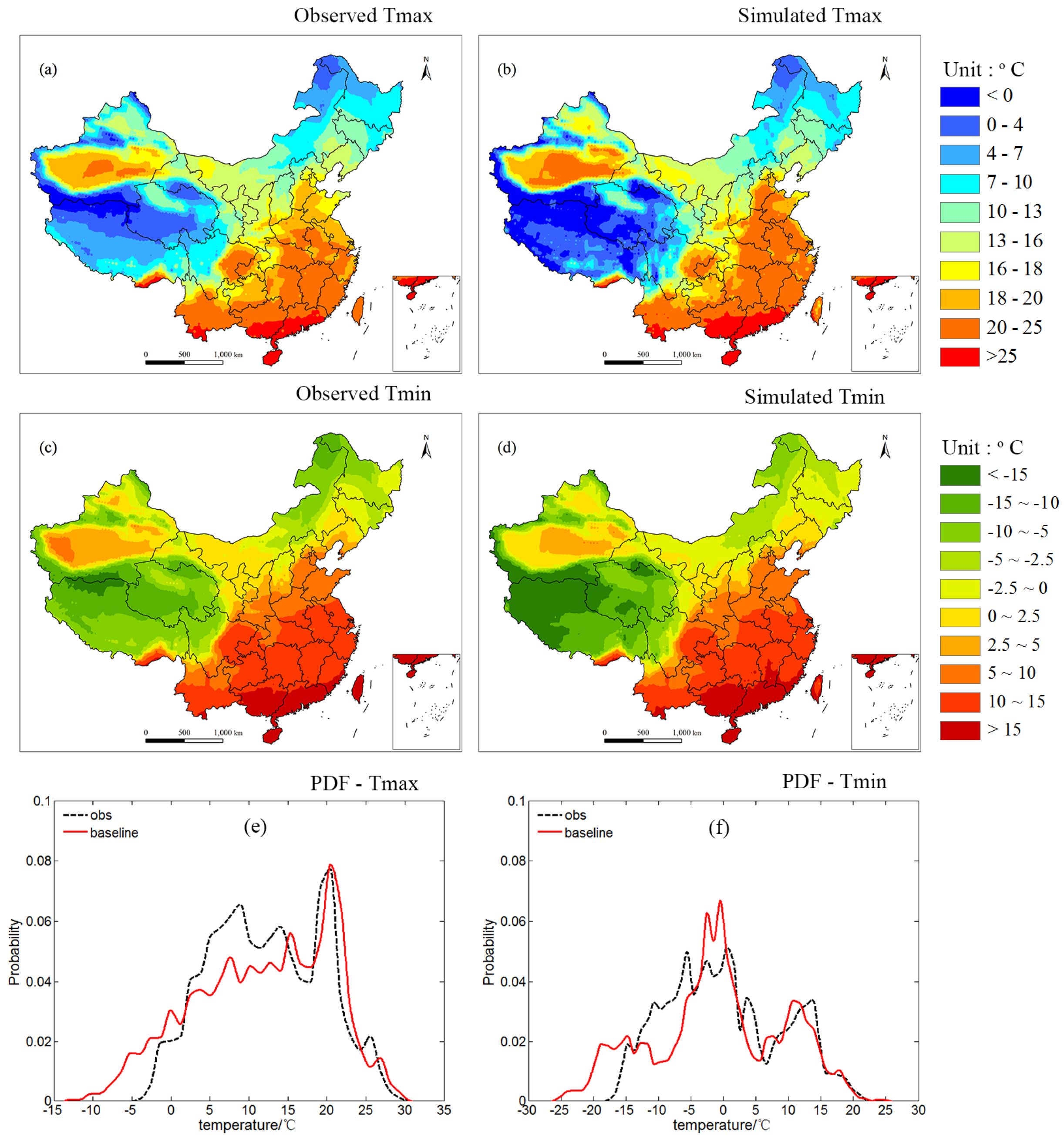
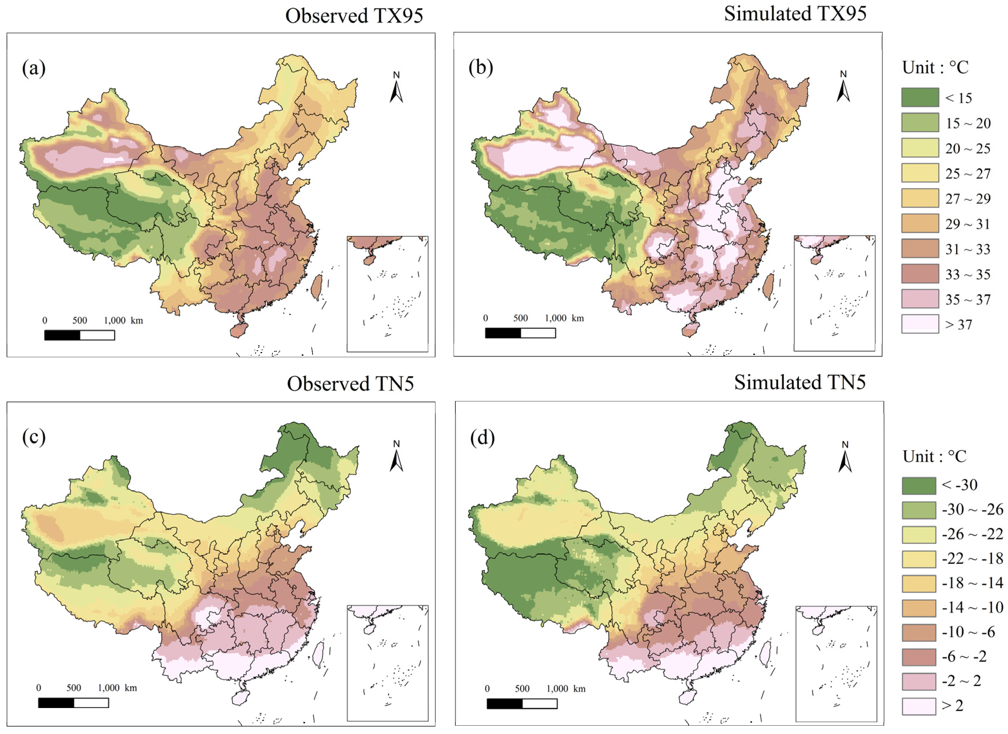
3.1. Validation of Extreme Temperature Indices in the Baseline Period
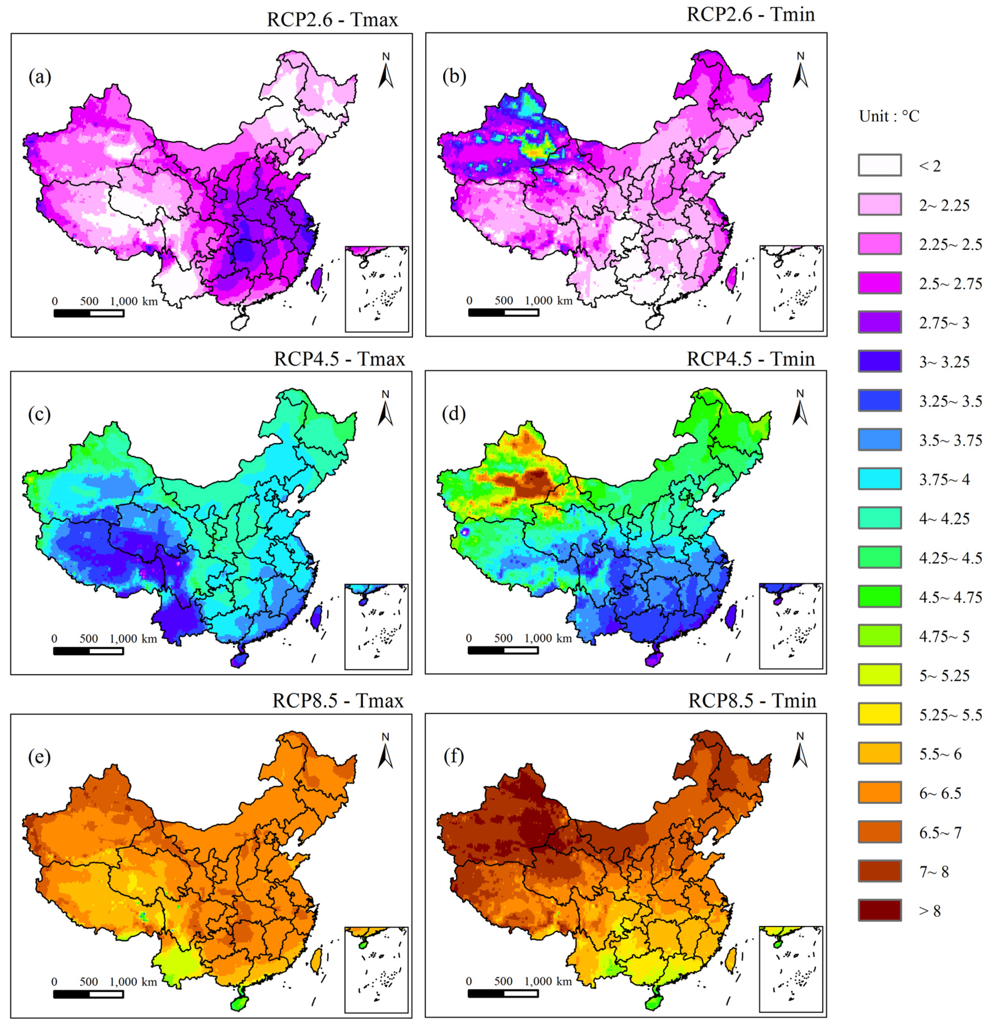
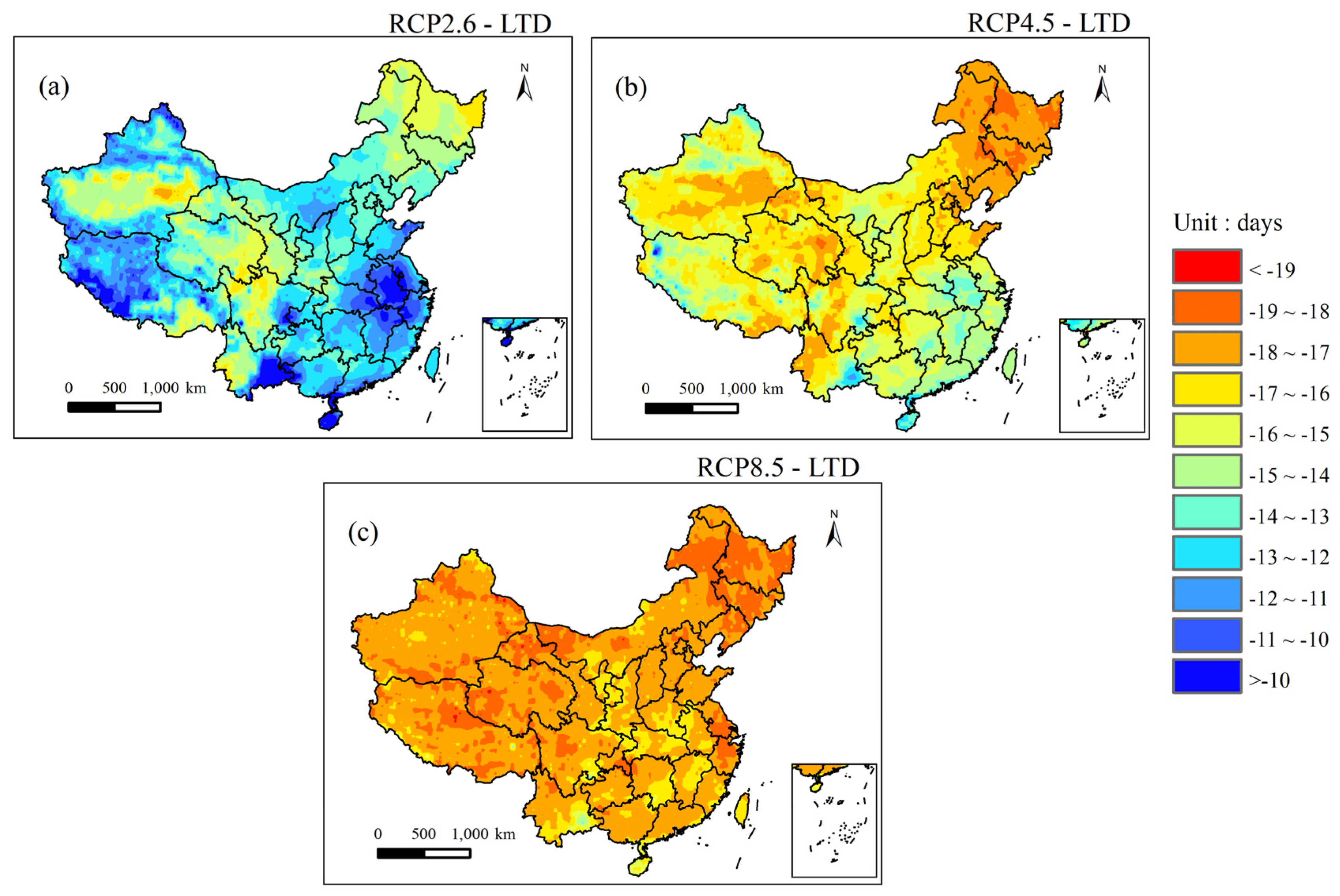
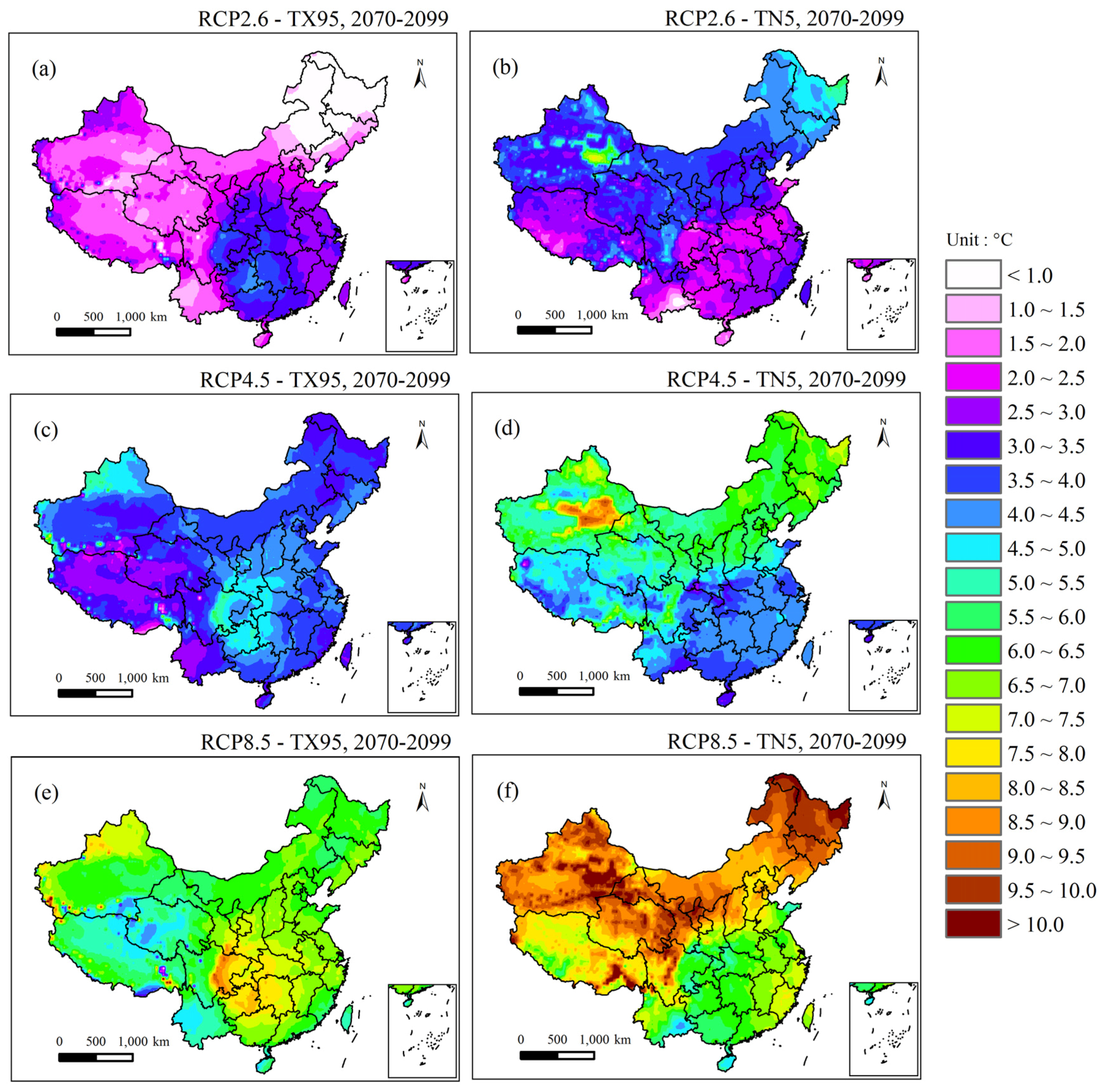
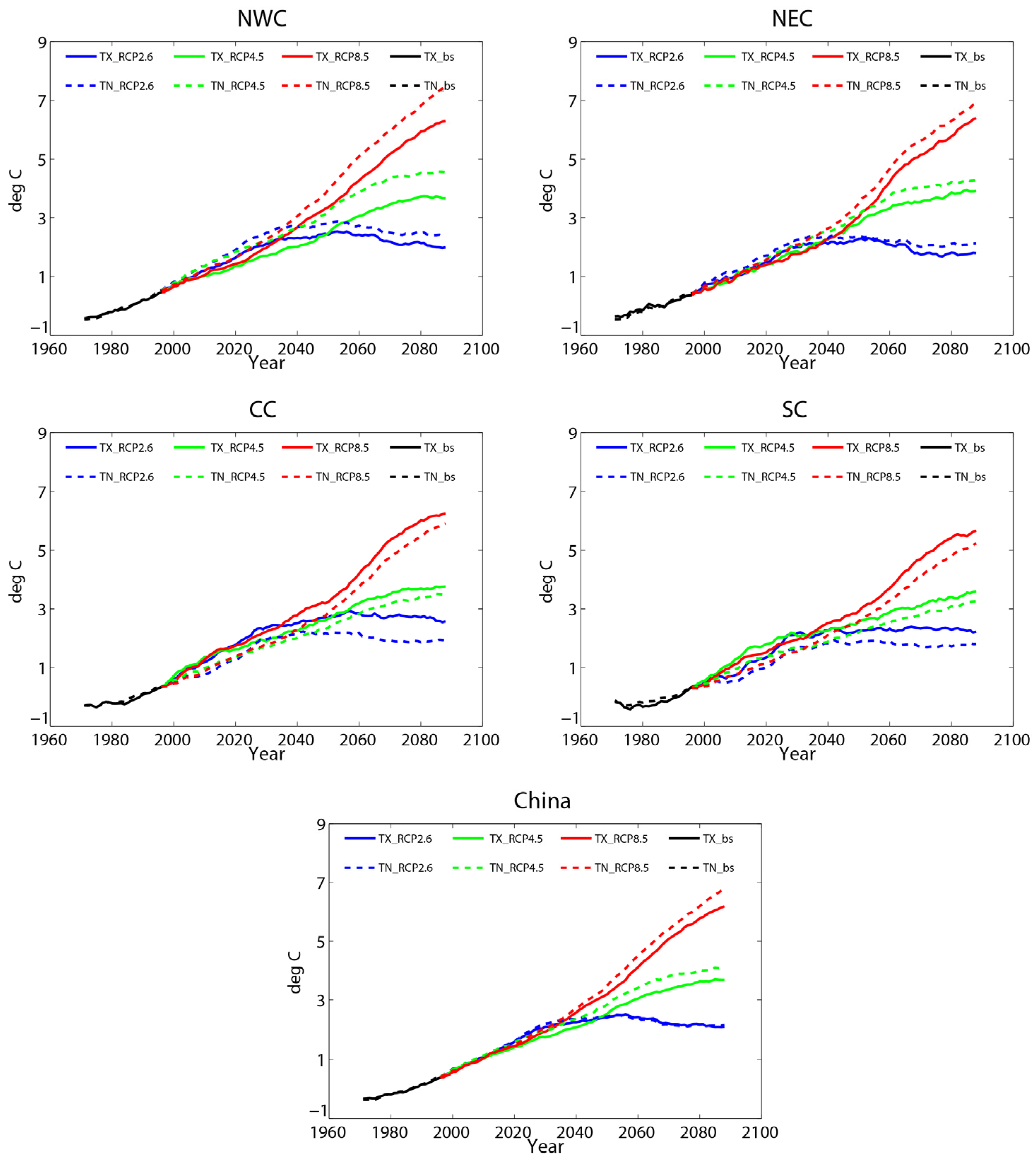
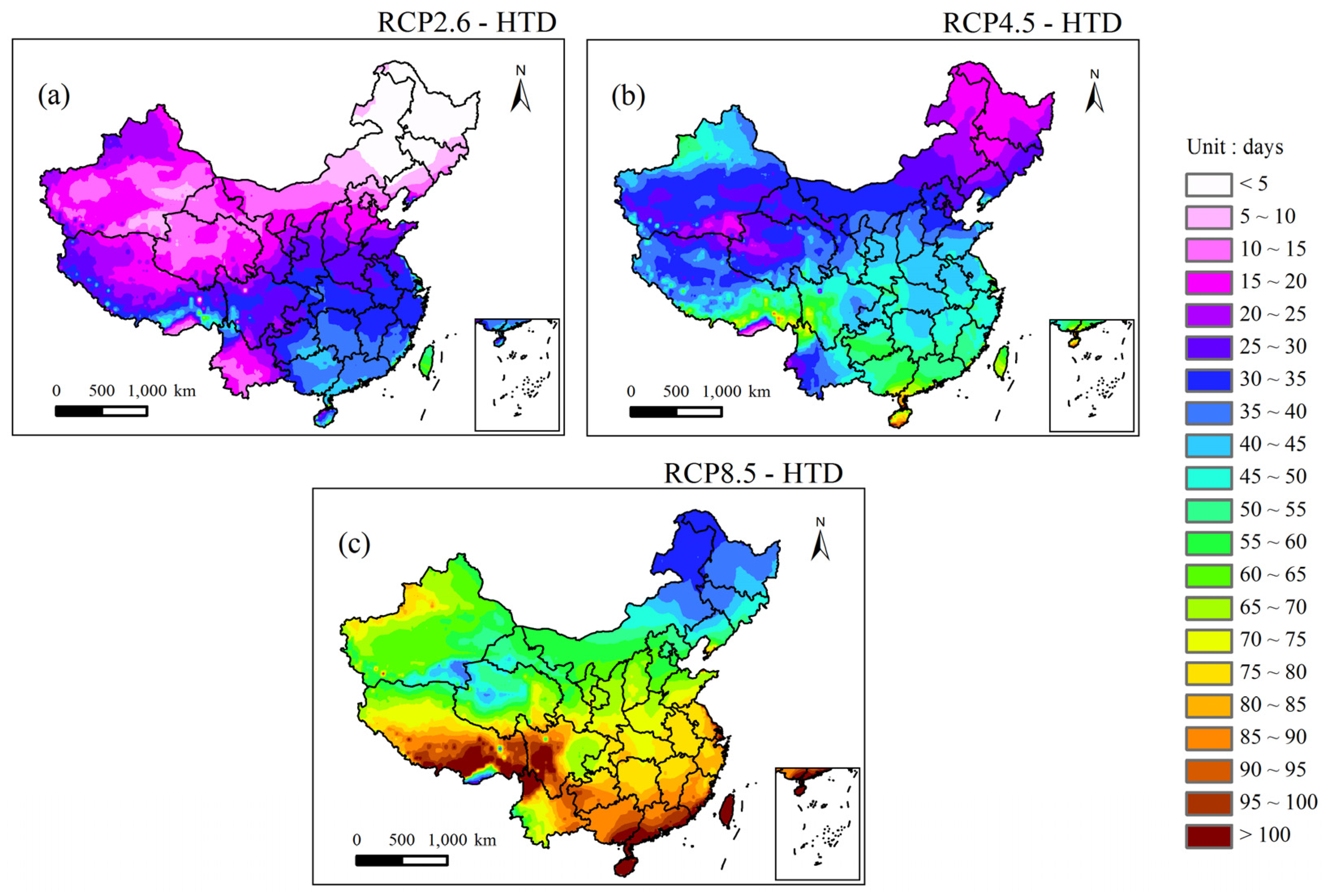
3.2. Projections of Extreme Temperatures in China under RCP Scenarios
4. Conclusions and Discussion
Acknowledgments
Author Contributions
Conflicts of Interest
References
- Stocker, T.F.; Qin, D.; Plattner, G.K.; Tignor, M.; Allen, S.K.; Boschung, J.; Nauels, A.; Xia, Y.; Bex, V.; Midgley, B.M. Climate Change 2013: The Physical Science Basis; Contribution of Working Group I to the Fifth Assessment Report of the Intergovernmental Panel on Climate Change; Cambridge University Press: Cambridge, UK; New York, NY, USA, 2013. [Google Scholar]
- Donat, M.G.; Alexander, L.V. The shifting probability distribution of global daytime and night-time temperatures. Geophys. Res. Lett. 2012, 39, L14707. [Google Scholar] [CrossRef]
- Vose, R.S.; Easterling, D.R.; Gleason, B. Maximum and minimum temperature trends for the globe: An update through 2004. Geophys. Res. Lett. 2005, 32, L23822. [Google Scholar] [CrossRef]
- Russo, S.; Sterl, A. Global changes in indices describing moderate temperature extremes from the daily output of a climate model. J. Geophys. Res. 2011, 116, D03104. [Google Scholar] [CrossRef]
- Marengo, J.A.; Jones, R.; Alves, L.M.; Valverde, M.C. Future change of temperature and precipitation extremes in South America as derived from the PRECIS regional climate modeling system. Int. J. Climatol. 2009, 29, 2241–2255. [Google Scholar] [CrossRef]
- Feng, S.; Hu, Q.; Huang, W.; Ho, C.H.; Li, R.; Tang, Z. Projected climate regime shift under future global warming from multi-model, multi-scenario CMIP5 simulations. Glob. Planet. Chang. 2014, 112, 41–52. [Google Scholar] [CrossRef]
- Kharin, V.V.; Zwiers, F.W.; Zhang, X.; Wehner, M. Changes in temperature and precipitation extremes in the CMIP5 ensemble. Clim. Chang. 2013, 119, 345–357. [Google Scholar] [CrossRef]
- Orlowsky, B.; Seneviratne, S.I. Global changes in extreme events: Regional and seasonal dimension. Clim. Chang. 2012, 110, 669–696. [Google Scholar] [CrossRef]
- Sillmann, J.; Kharin, V.V.; Zwiers, F.W.; Zhang, X.; Bronaugh, D. Climate extremes indices in the CMIP5 multimodel ensemble: Part 2. Future climate projections. J. Geophys. Res. Atmos. 2013, 118, 2473–2493. [Google Scholar] [CrossRef]
- Bennett, K.E.; Walsh, J.E. Spatial and temporal changes in indices of extreme precipitation and temperature for Alaska. Int. J. Climatol. 2015, 35, 1434–1452. [Google Scholar] [CrossRef]
- Min, S.K.; Zhang, X.B.; Zwiers, F.; Shiogama, H.; Tung, Y.S.; Wehner, M. Multimodel detection and attribution of extreme temperature changes. J. Clim. 2013, 26, 7430–7451. [Google Scholar] [CrossRef]
- Braganza, K.; Karoly, D.J.; Arblaster, J.M. Diurnal temperature range as an index of global climate change during the twentieth century. Geophys. Res. Lett. 2004, 31, L13217. [Google Scholar] [CrossRef]
- Wang, K.; Ye, H.; Tang, L.N.; Chen, F.; Xiong, Y.Z.; Li, X.Y. Research progresses on diurnal temperature range: Variation trend and influential factors. Adv. Clim. Chang. Res. 2010, 6, 417–423. (In Chinese) [Google Scholar]
- Editing Commission of the Third National Report on Climate Change of China. The Third National Report on Climate Change; Science Press: Beijing, China, 2015. (In Chinese)
- Chen, L.; Frauenfeld, O.W. Surface air temperature changes over the twentieth and twenty-first centuries in China simulated by 20 CMIP5 models. J. Clim. 2014, 27, 3920–3937. [Google Scholar] [CrossRef]
- Xu, C.H.; Xu, Y. The projection of temperature and precipitation over China under RCP scenarios using a CMIP5 multi-model ensemble. Atmos. Ocean. Sci. Lett. 2012, 5, 527–533. [Google Scholar]
- Liu, Y.; Feng, J.; Ma, Z. An analysis of historical and future temperature fluctuations over China based on CMIP5 simulations. Adv. Atmos. Sci. 2014, 31, 457–467. [Google Scholar] [CrossRef]
- Wang, L.; Chen, W. A CMIP5 multimodel projection of future temperature, precipitation, and climatological drought in China. Int. J. Climatol. 2014, 34, 2059–2078. [Google Scholar] [CrossRef]
- Wang, H.J.; Sun, J.Q.; Chen, H.P.; Zhu, Y.L.; Zhang, Y.; Jiang, D.B.; Lang, X.M.; Fan, K.; Yu, E.T.; Yang, S. Extreme climate in China: Facts, simulation and projection. Meteorol. Z. 2012, 21, 279–304. [Google Scholar]
- Sun, Y.; Zhang, X.; Zwiers, F.W.; Song, L.; Wan, H.; Hu, T.; Yin, H.; Ren, G. Rapid increase in the risk of extreme summer heat in Eastern China. Nat. Clim. Chang. 2014, 4, 1082–1085. [Google Scholar] [CrossRef]
- China Climate Bulletin. Available online: http://www.cma.gov.cn/2011xwzx/2011xqxyw/20160112_301724.html (accessed on 12 January 2016).
- Xu, X.; Du, Y.; Tang, J.; Wang, Y. Variations of temperature and precipitation extremes in recent two decades over China. Atmos. Res. 2011, 101, 143–154. [Google Scholar] [CrossRef]
- Ji, Z.; Kang, S. Evaluation of extreme climate events using a regional climate model for China. Int. J. Climatol. 2015, 35, 888–902. [Google Scholar] [CrossRef]
- Liu, J.; Du, H.; Wu, Z.; He, H.S.; Wang, L.; Zong, S. Recent and future changes in the combination of annual temperature and precipitation throughout China. Int. J. Climatol. 2016. [Google Scholar] [CrossRef]
- Ramos, A.M.; Trigo, R.M.; Santo, F.E. Evolution of extreme temperatures over portugal: Recent changes and future scenarios. Clim. Res. 2011, 48, 177–192. [Google Scholar] [CrossRef]
- Yang, J.; Liu, H.Z.; Ou, C.Q.; Lin, G.Z.; Zhou, Q.; Shen, G.C.; Chen, P.Y.; Guo, Y.M. Global climate change: Impact of diurnal temperature range on mortality in guangzhou, China. Environ. Pollut. 2013, 175, 131–136. [Google Scholar] [CrossRef] [PubMed]
- Zhang, X.; Alexander, L.; Hegerl, G.C.; Jones, P.; Tank, A.K.; Peterson, T.C.; Trewin, B.; Zwiers, F.W. Indices for monitoring changes in extremes based on daily temperature and precipitation data. Wiley Interdiscip. Rev.-Clim. Chang. 2011, 2, 851–870. [Google Scholar] [CrossRef]
- Rajczak, J.; Pall, P.; Schär, C. Projections of extreme precipitation events in regional climate simulations for Europe and the Alpine Region. J. Geophys. Res.-Atmos. 2013, 118, 3610–3626. [Google Scholar] [CrossRef]
- Boo, K.-O.; Kwon, W.-T.; Baek, H.-J. Change of extreme events of temperature and precipitation over Korea using regional projection of future climate change. Geophys. Res. Lett. 2006, 33, L01701. [Google Scholar] [CrossRef]
- Moss, R.H.; Edmonds, J.A.; Hibbard, K.A.; Manning, M.R.; Rose, S.K.; van Vuuren, D.P.; Carter, T.R.; Emori, S.; Kainuma, M.; Kram, T.; et al. The next generation of scenarios for climate change research and assessment. Nature 2010, 463, 747–756. [Google Scholar] [CrossRef] [PubMed]
- Rao, K.K.; Patwardhan, S.K.; Kulkarni, A.; Kamala, K.; Sabade, S.S.; Kumar, K.K. Projected changes in mean and extreme precipitation indices over India using PRECIS. Glob. Planet. Chang. 2014, 113, 77–90. [Google Scholar] [CrossRef]
- Liu, C.B.; Ji, X.X.; Xu, Y.L.; Wang, M.X.; Zhang, L.; Pan, J.; Hu, Y.N.; Tong, J.H. Analysis of changes in the maximum and minimum temperature and diurnal temperature range from PRECIS model under the SRES A1B scenario for China. Clim. Environ. Res. 2015, 20, 89–96. (In Chinese) [Google Scholar]
- Simmons, A.J.; Burridge, D.M. An energy and angular-momentum conserving vertical finite-difference scheme and hybrid vertical coordinates. Mon. Weather Rev. 1981, 109, 758–766. [Google Scholar] [CrossRef]
- Jones, C.D.; Hughes, J.K.; Bellouin, N.; Hardiman, S.C.; Jones, G.S.; Knight, J.; Liddicoat, S.; O’Connor, F.M.; Andres, R.J.; Bell, C.; et al. The HadGEM2-ES implementation of CMIP5 centennial simulations. Geosci. Model Dev. 2011, 4, 543–570. [Google Scholar] [CrossRef]
- Xu, Y.; Gao, X.J.; Shen, Y.; Xu, C.H.; Shi, Y.; Giorgi, F. A daily temperature dataset over China and its application in validating a RCM simulation. Adv. Atmos. Sci. 2009, 26, 763–772. [Google Scholar] [CrossRef]
- Estévez, J.; Gavilán, P.; Giráldez, J.V. Guidelines on validation procedures for meteorological data from automatic weather stations. J. Hydrol. 2011, 402, 144–154. [Google Scholar] [CrossRef]
- Xu, Y.L.; Pan, J.; Feng, Q. Projection on Future Climate Change in China- Constructing High Resolution SRES Climate Scenarios Using PRECIS; Science Press: Beijing, China, 2016. [Google Scholar]
- Wu, J.; Gao, X.J. A gridded daily observation dataset over China region and comparison with the other datasets. Diqiu Wuli Xuebao 2013, 56, 1102–1111. (In Chinese) [Google Scholar]
- You, Q.; Min, J.; Fraedrich, K.; Zhang, W.; Kang, S.; Zhang, L.; Meng, X. Projected trends in mean, maximum, and minimum surface temperature in China from simulations. Glob. Planet. Chang. 2014, 112, 53–63. [Google Scholar] [CrossRef]
- Wang, B.; Zhang, M.; Wei, J.; Wang, S.; Li, S.; Ma, Q.; Li, X.F.; Pan, S.K. Changes in extreme events of temperature and precipitation over Xinjiang, northwest China, during 1960–2009. Quat. Int. 2013, 298, 141–151. [Google Scholar] [CrossRef]
- Pal, J.S.; Eltahir, E.A.B. Future temperature in southwest Asia projected to exceed a threshold for human adaptability. Nat. Clim. Chang. 2015, 6, 197–200. [Google Scholar] [CrossRef]
- Tebaldi, C.; Wehner, M.F. Benefits of mitigation for future heat extremes under RCP4.5 compared to RCP8.5. Clim. Chang. 2016, 1–13. [Google Scholar] [CrossRef]


| Code | Index | Description | Unit |
|---|---|---|---|
| TX95 | Threshold of extreme hot days | 95th percentile of all of the maximum temperatures | ° C |
| TN5 | Threshold of extreme cold days | 5th percentile of all of the minimum temperatures | ° C |
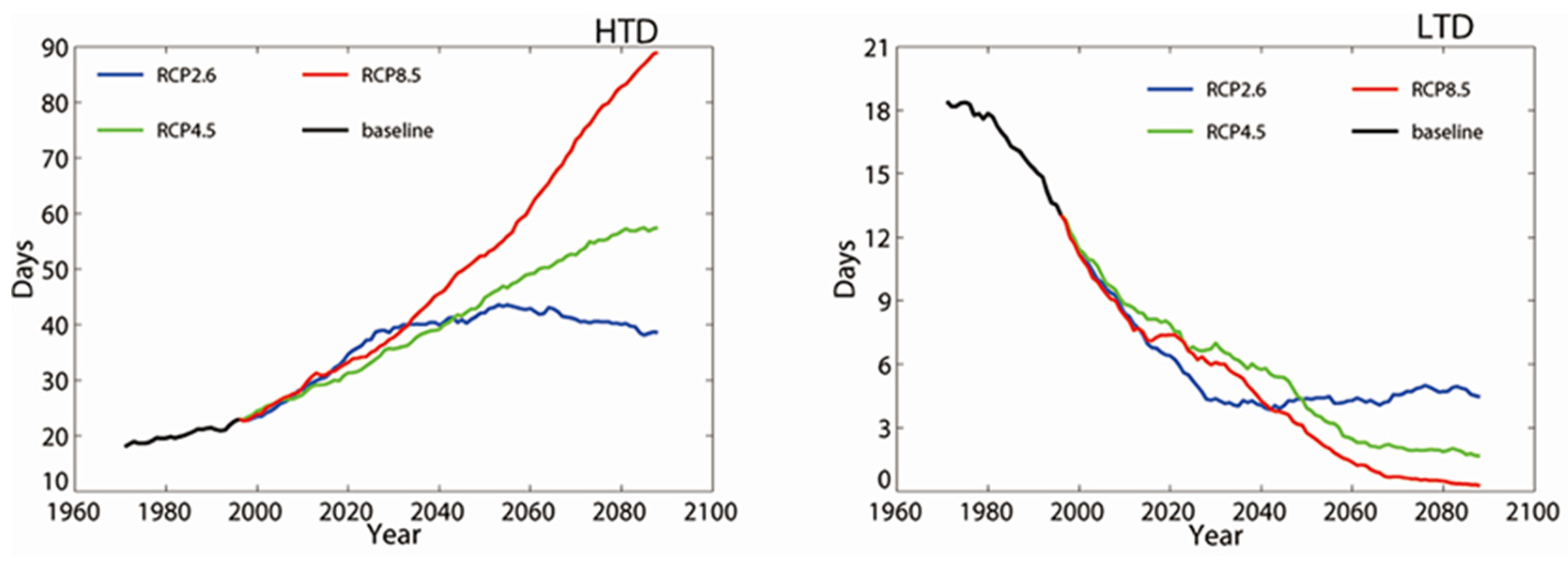
| HTD | High-temperature days | Number of days in a year with the maximum temperature exceeding TX95 (over 1961–1990) | day |
| LTD | Low-temperature days | Number of days in a year with the minimum temperature below TN5 (over 1961–1990) | day |
© 2017 by the authors; licensee MDPI, Basel, Switzerland. This article is an open access article distributed under the terms and conditions of the Creative Commons Attribution (CC-BY) license (http://creativecommons.org/licenses/by/4.0/).
Share and Cite
Zhang, Y.; Fu, L.; Pan, J.; Xu, Y. Projected Changes in Temperature Extremes in China Using PRECIS. Atmosphere 2017, 8, 15. https://doi.org/10.3390/atmos8010015
Zhang Y, Fu L, Pan J, Xu Y. Projected Changes in Temperature Extremes in China Using PRECIS. Atmosphere. 2017; 8(1):15. https://doi.org/10.3390/atmos8010015
Chicago/Turabian StyleZhang, Yujing, Liang Fu, Jie Pan, and Yinlong Xu. 2017. "Projected Changes in Temperature Extremes in China Using PRECIS" Atmosphere 8, no. 1: 15. https://doi.org/10.3390/atmos8010015
APA StyleZhang, Y., Fu, L., Pan, J., & Xu, Y. (2017). Projected Changes in Temperature Extremes in China Using PRECIS. Atmosphere, 8(1), 15. https://doi.org/10.3390/atmos8010015