Article

Climatological and Hydrological Extremes of the Andaman and Nicobar Islands, India, and Its Database for Public Users

by
Abhilash
1,*,
Anurag Satpathi
2,*,
Talaviya Harshangkumar
1,
Thangavel Subramani
1,
Iyyappan Jaisankar
1 and
Namendra Kumar Shahi
3
1
Division of Natural Resource Management (NRM), ICAR-Central Island Agricultural Research Institute, Sri Vijaya Puram 744105, India
2
Division of Agrometeorology, Sher-e-Kashmir University of Agricultural Sciences and Technology of Kashmir, Srinagar 190025, India
3
Institute of Meteorology and Climate Research, Department Troposphere Research (IMK-TRO), Karlsruhe Institute of Technology (KIT), 76131 Karlsruhe, Germany
*
Authors to whom correspondence should be addressed.
Atmosphere 2025, 16(3), 301; https://doi.org/10.3390/atmos16030301
Submission received: 18 January 2025 / Revised: 24 February 2025 / Accepted: 26 February 2025 / Published: 4 March 2025

Abstract

:
The Andaman and Nicobar Islands experience a climate characterized by consistently high humidity, substantial annual precipitation, and moderate temperature fluctuations. The region’s susceptibility to extreme weather events—such as cyclones, heavy precipitation, and rising sea levels - highlights the need for a thorough understanding of its climatic patterns. In light of this, this study provides a comprehensive analysis of spatiotemporal variability and trends in mean and extreme precipitation across the Andaman and Nicobar Islands using long-term (i.e., 1981–2023) high-resolution Climate Hazards Group InfraRed Precipitation with Station data (CHIRPS). Our findings indicate a significant increase in monsoonal precipitation, particularly in South Andaman, where the mean precipitation trend is 11.10 mm/year, compared to 6.54 mm/year in Nicobar. Light-to-moderate precipitation events occur more frequently than heavy precipitation across all districts, although heavy precipitation is more frequent in Andaman than in Nicobar. Significant decadal increases in light-to-moderate precipitation events are found across most of Nicobar, while parts of Andaman showed a rise in the frequency of moderate-to-heavy precipitation events. Trend analysis of the highest single-day precipitation annually reveals mixed patterns, with increases noted in North and Middle Andaman (3.66 mm per decade) and South Andaman (1.13 mm per decade), while Nicobar shows a slight decrease (−0.63 mm per decade). Maximum consecutive five-day precipitation trends indicate significant annual increases in North and Middle Andaman (14.98 mm per decade) and South Andaman (3.49 mm per decade), highlighting the variability in extreme precipitation events. The observed trends in precipitation and its extremes highlight the heterogeneity of precipitation patterns, which are critical for water resource management, agriculture, and disaster risk mitigation in the region, particularly in the context of increasing precipitation variability and intensity driven by climate change. Further investigation is needed to understand the physical mechanisms driving the increase in frequency and intensity of precipitation, which will be addressed in a separate paper.

1. Introduction

The Andaman and Nicobar Islands, an archipelago of over 500 islands located in the Bay of Bengal, play a critical role in India’s meteorological and hydrological systems [1]. These islands, endowed with a unique geographical location and diverse ecosystems, are profoundly influenced by the interplay of tropical weather patterns, monsoon dynamics, and ocean–atmosphere interactions [2]. The climate of the Andaman and Nicobar Islands is characterized by high humidity, significant precipitation, and moderate temperature variations throughout the year, largely governed by the southwest and northeast monsoons. The region’s vulnerability to extreme weather events such as cyclones, torrential precipitation, and rising sea levels underscores the importance of understanding its climatic behaviour [3]. These phenomena not only pose risks to local communities but also have cascading effects on marine biodiversity, freshwater resources, and terrestrial ecosystems [1]. Historically, the Andaman and Nicobar Islands have been a hotspot for cyclonic activities originating in the Bay of Bengal, making it critical to monitor and study their climatology and hydrological extremes [4].
Climate change is a significant stressor impacting the marine ecosystems and biodiversity of the Andaman and Nicobar Islands [5]. Marks et al. [6] reported that 59% of people surveyed were very or extremely worried about climate change, with 84% being at least moderately concerned.
Despite their ecological significance and strategic importance, detailed studies on the climatology and hydrological extremes specific to this region remain limited. Understanding the temporal and spatial patterns of precipitation and other meteorological variables is crucial for hydrologists, agriculturalists, meteorologists, and industrial stakeholders to ensure the sustainable management of water resources [7]. Recent studies have examined the spatiotemporal trends and magnitudes of meteorological variables (precipitation, evapotranspiration, temperature, humidity, etc.) using parametric methods such as simple linear regression and non-parametric tests, including the Mann–Kendall test, modified Mann–Kendall test, Theil–Sen slope, Spearman’s rho, and Kendall’s rank correlation [8,9,10,11,12,13,14]. Most previous studies investigating trends in precipitation and precipitation extremes have relied on the Mann–Kendall test, which has demonstrated its utility in identifying significant trends in hydrological data across various probability levels [12,15]. However, this test operates under the assumption of spatial and temporal independence in hydrological time series data [16,17,18].
Previous research has extensively examined precipitation patterns and variability across annual, seasonal, and monthly periods. However, investigations into precipitation extremes have predominantly focused on annual scales and the monsoon season, with limited attention given to the winter, pre-monsoon, and post-monsoon periods [19]. Bisht et al. [12] emphasized the importance of regional-level trend analyses of precipitation characteristics to facilitate more informed decision-making. Vittal et al. [20] identified significant shifts in the patterns of precipitation extremes when comparing the post-1950 period to the pre-1950 era. Kundu and Modal [21] conducted a long-term analysis of annual and seasonal precipitation trends, identifying change points in annual precipitation over a 102-year period in West Bengal, India, using the Mann–Kendall test and Sen’s slope estimator. Malik et al. [22] examined spatial and temporal precipitation trends across seasonal (pre-monsoon, monsoon, post-monsoon, and winter) and annual time series datasets from 13 stations in the central Himalayan region of Uttarakhand, India. Further, Malik and Kumar [23] extended this analysis to monthly, seasonal, and annual scales across 13 districts in the central Himalayan region of Uttarakhand State, offering deeper insights into spatial and temporal variability.
Sridhar and Pai [24] analysed a 70-year (1951–2020) daily gridded precipitation dataset for the Andaman and Nicobar and Lakshadweep Islands, identifying trends and frequency changes in moderate and heavy precipitation events during 1971–2020. Kumar et al. [25] studied the precipitation patterns of the Andaman and Nicobar Islands and observed an increasing trend in the frequency of rather heavy rain (35.6–64.4 mm), alongside a significant decreasing trend in light rain (2.5–7.5 mm) and very heavy rain (>124.5 mm). Velmurugan et al. [26] also concluded that climate change would lead to an increase in sea level and temperature, further emphasizing the region’s vulnerability to its long-term impacts. Roy and Chakravarty [27] analysed 35 years of precipitation data (1980–2015) from six stations in the Andaman and Nicobar Islands using the Mann–Kendall test, Sen’s slope, and regression analysis. Their findings indicated that four stations—Mayabandar, Long Island, Port Blair, and Car Nicobar—exhibited an increasing trend in annual and monsoon precipitation, while Hut Bay and Nancowry showed a decreasing trend.
While normal trend analyses have been conducted in the past for the Andaman and Nicobar Islands, the majority of these studies relied on point-based ground-observation-based data sources. However, the availability of ground-based meteorological stations in this region is sparse due to challenging terrain and logistical constraints. As a result, capturing the spatial variability of precipitation patterns remains a significant challenge. This limitation highlights the need for utilizing high-resolution gridded datasets and remote sensing techniques to analyse extreme precipitation events comprehensively. This study aims to bridge this gap by leveraging such datasets to provide a more detailed understanding of precipitation variability and trends in the region and by offering a comprehensive analysis of climatic patterns and extreme hydrological events in the Andaman and Nicobar Islands, while developing an accessible database for public use. The findings of this study are expected to contribute significantly to the fields of climate science and disaster management, as very few attempts have been made to study the climatology and hydrological extremes of the Andaman and Nicobar Islands. This study is motivated by the pressing need to address the following objectives: (i) to analyse the long-term climatological trends and hydrological extremes in the Andaman and Nicobar Islands, focusing on precipitation variability, temperature patterns, and cyclone frequency; (ii) to develop predictive models to assess the potential impacts of climate change on the region’s weather patterns and hydrological balance; and (iii) to create a publicly accessible database containing high-resolution climatological and hydrological data for the Andaman and Nicobar Islands to support research, disaster management, and sustainable development initiatives.

2. Materials and Methods

2.1. Study Area

The Land Use and Land Cover (LULC) map serves as a foundational element for understanding the spatial heterogeneity and ecological dynamics of the region [28]. Figure 1 illustrates the location map of the study area with elevation (in meters) based on the Shuttle Radar Topography Mission (SRTM) Digital Elevation Model (DEM) at 1 arc-second resolution and LULC classification of the Andaman and Nicobar Islands, derived from MODIS satellite data, highlighting various land cover types across the region with their respective covered area. The LULC map for this study was created using the 2022 MODIS MCD12Q1 Version 6.1 dataset, which provides global land cover classification through supervised classification of MODIS Terra and Aqua reflectance data, and was further refined using ancillary information and prior knowledge. Evergreen broadleaf forest (72.46%) was found to be the highest in the study region, followed by water bodies (13.37%).

2.2. Analysis and Data Used

This study utilized the Climate Hazards Group InfraRed Precipitation with Station data (CHIRPS), a reliable and high-resolution precipitation dataset designed for comprehensive climatological and hydrological studies [29]. CHIRPS is a 35+-year quasi-global precipitation dataset that spans latitudes from 50° S to 50° N and includes all longitudes, covering the period from 1981 to the near-present. This dataset integrates Climate Hazards Precipitation Climatology (CHPclim) as its baseline climatology, complemented by 0.05°-resolution satellite-derived imagery and in situ station observations. For this study, CHIRPS data were employed to analyse long-term precipitation patterns and their variability. The reliability of CHIRPS data for precipitation analysis has been validated in various studies, demonstrating their accuracy in representing precipitation patterns [30,31,32,33,34,35]. Apart from this, correlation analyses were conducted between CHIRPS-derived precipitation estimates and ground-based observations at six meteorological stations. The correlation coefficients for daily, monthly, and annual precipitation are presented in Table 1. These results indicate that daily precipitation values exhibited a relatively low correlation with ground observations, ranging from 0.244 to 0.379. This lower agreement at the daily scale may be attributed to the inherent limitations of gridded datasets in capturing localized convective precipitation events, errors in satellite-based retrievals, and the influence of complex topography on precipitation distribution. However, the correlation improved significantly at the monthly scale (0.537–0.772), suggesting that CHIRPS data can effectively capture aggregated precipitation trends over longer timeframes. The highest agreement was observed at the annual scale (0.662–0.938), indicating that CHIRPS data provide a reliable representation of long-term precipitation variability in the region. These findings validate the use of CHIRPS data for analysing extreme precipitation events while acknowledging their limitations at finer temporal resolutions.

2.3. Precipitation Variability

To analyse precipitation variability across the Andaman and Nicobar Islands, the Coefficient of Variation (CV) was calculated for seasonal precipitation during the winter, pre-monsoon, monsoon, and post-monsoon periods over the study period (1981–2023). The CV is a statistical measure that quantifies the relative dispersion of precipitation, expressed as a percentage of the mean. Using CHIRPS gridded precipitation data at a spatial resolution of 0.05°, seasonal precipitation totals were extracted for each pixel across the study area. The CV for each pixel was computed as the ratio of the standard deviation to the mean seasonal precipitation, multiplied by 100, allowing for the spatial representation of precipitation variability. This pixel-level analysis provides insights into the consistency of seasonal precipitation patterns, with higher CV values indicating regions with greater variability and less predictable precipitation distribution.

2.4. Precipitation Categorization

To analyse seasonal rain, daily precipitation data for each district and agroclimatic zone and the entire region were aggregated to calculate the total seasonal precipitation. Following the IMD classification system [36], rain in any season was categorized into five distinct classes based on deviations from normal precipitation: (i) large excess (+60% and above), (ii) excess (+20% to +59%), (iii) normal (−19% to +19%), (iv) deficient (−59% to −20%), and (v) large deficient (−60% and below). This classification scheme was applied to capture the spatiotemporal variability of seasonal precipitation across Andaman and Nicobar Island during the study period, enabling the identification of trends and anomalies in precipitation distribution.

2.5. Trend Analysis

To assess long-term trends in precipitation variability, the Trend-Free Pre-Whitening (TFPW) Mann–Kendall test [37,38] and Sen’s slope estimator were employed. The TFPW Mann–Kendall test is a robust non-parametric statistical approach that evaluates the significance of monotonic trends in time series data while eliminating the influence of serial correlation, which can otherwise lead to spurious results. This method involves pre-whitening the data to remove the effects of autocorrelation, followed by the application of the Mann–Kendall test to detect trends. The Mann–Kendall test is a widely used non-parametric method for detecting monotonic trends in time series data. Its key advantage is that it does not require the data to be normally distributed and is less sensitive to outliers. However, a limitation of the Mann–Kendall test is that it assumes independence of data points, which may not always hold true for meteorological datasets that exhibit autocorrelation.
Complementing this, Sen’s slope estimator provides a quantification of the trend magnitude, offering an unbiased measure of the rate of change per unit time [39]. Sen’s slope estimator is employed to quantify the magnitude of the trend detected by the Mann–Kendall test. It is a robust and non-parametric approach that is less influenced by outliers compared to parametric regression methods. However, it assumes a linear trend over time, which may not always capture complex climatic variations. Together, these methods enable a comprehensive analysis of precipitation patterns, allowing for the identification of statistically significant trends and their magnitude, which are crucial for understanding climate variability and its implications on regional hydrological cycles.

2.6. Extreme Precipitation Events and Indices

The Expert Team on Climate Change Detection and Indices (ETCCDI), under the Commission for Climatology (CCl) of the World Meteorological Organization (WMO), developed a standardized set of climate extreme indices to analyse trends and variability in temperature and precipitation based on daily observational data [40,41]. For this study, 11 precipitation-related indices were selected to evaluate the frequency, intensity, and duration of extreme precipitation events in the Andaman and Nicobar Islands. Details of these indices are given in Table 2. The chosen indices provide critical insights into changing precipitation patterns, enabling a robust assessment of extreme events and their implications on the regional climate.

3. Results and Discussions

3.1. Precipitation Dynamics

During the winter season, precipitation trends indicated a gradual increase across the Andaman and Nicobar Islands. The linear slope values suggest an increasing trend of 1.06 mm/year for the entire region, with North and Middle Andaman showing a slope of 0.72 mm/year, South Andaman 0.67 mm/year, and Nicobar 2.01 mm/year. Notably, Nicobar exhibited the highest increasing trend, likely due to its proximity to the equator, where enhanced convective activities and occasional northeast monsoon surges contribute to higher precipitation. A similar finding regarding the consistently higher intensity of daily precipitation in the Nicobar district was also reported by Kumar et al. [25]. In the pre-monsoon season, the precipitation trend continued to rise, with Andaman and Nicobar Islands experiencing an increase of 2.14 mm/year. North and Middle Andaman displayed the highest increasing trend at 2.55 mm/year, followed by South Andaman at 0.34 mm/year, whereas Nicobar showed a minimal increase of 0.04 mm/year. The stronger upward trend in North and Middle Andaman indicates early convective system development, potentially influenced by localized atmospheric dynamics and warming trends. The monsoon season exhibited the most significant precipitation accumulation, accompanied by the highest increasing trends. The Andaman and Nicobar Islands as a whole showed a strong increasing trend of 9.41 mm/year, with South Andaman experiencing the sharpest increase at 11.53 mm/year, followed by North and Middle Andaman at 9.46 mm/year. Nicobar, while still showing an increasing trend, recorded a comparatively lower slope of 7.28 mm/year. This pattern aligns with the monsoon’s orographic effects, where moisture-laden winds interact with the Andaman terrain, leading to enhanced precipitation in the central and northern districts. During the post-monsoon season, the increasing trend was relatively moderate compared to the monsoon season. The Andaman and Nicobar Islands exhibited an overall increase of 1.84 mm/year, with South Andaman displaying the highest trend at 1.94 mm/year, followed by Nicobar at 2.84 mm/year, and North and Middle Andaman at 1.42 mm/year. The overall seasonal changes in precipitation observed in this study are consistent with the findings of Velmurugan et al. [42], which also highlighted significant spatial and temporal variability across the region. The seasonal distribution of precipitation across the Andaman and Nicobar Islands exhibited notable spatial and temporal variability over the period 1981–2023, as shown in Figure 2.

3.2. Precipitation Variability

During the winter season, South Andaman exhibited the highest mean CV of 81.49%, indicating considerable variability in precipitation, with values ranging from 56.21% to 113.85%, suggesting a more erratic precipitation distribution. In contrast, North and Middle Andaman showed a mean CV of 62.74%, with variability ranging from 36.44% to 89.42%. Nicobar presented a mean CV of 65.71%, suggesting moderate variability within its precipitation distribution, with values ranging from 60.47% to 83.09%. The substantial variability in winter precipitation may result from the influence of localized weather systems and the intermittent nature of precipitation during this time, leading to greater inconsistencies in precipitation amounts. The pre-monsoon season showed moderate variability as variability decreased across all districts, with South Andaman and North and Middle Andaman exhibiting mean CVs of 38.11% and 39.10%, respectively, while Nicobar showed the lowest variability at 31.06%, with values ranging from 27.65% to 41.43%. This reflects a transition phase where precipitation patterns begin to stabilize as the region approaches the monsoon. This transitional variability can be influenced by changing atmospheric conditions, including the buildup of moisture in anticipation of the monsoon onset. Adamala and Velmurugan [1] observed similar transitional trends in precipitation across the Andaman and Nicobar Islands, emphasizing that the pre-monsoon variability is a critical indicator of seasonal preparedness for agricultural activities. During the monsoon season, the variability remained notably low. South Andaman and North and Middle Andaman had mean CVs of 23.73% and 23.41%, respectively, while Nicobar showed a slightly higher variability at 25.85%, ranging from 20.75% to 28.70%, indicating a more stable and consistent precipitation pattern. This stability can be attributed to the prevailing monsoonal winds, which lead to regular and abundant precipitation, thereby reducing variability within this season. This finding corroborates Sharma et al. [43], who documented a similar reduction in monsoon precipitation variability across the Upper Tapi Basin, attributing it to robust monsoonal dynamics. Finally, in the post-monsoon season, North and Middle Andaman had the highest mean CV (44.01%), followed by South Andaman (40.55%) and Nicobar (30.80%), indicating that variability increases again after the monsoon. This increase can be attributed to the diminishing influence of the monsoon, where precipitation becomes less predictable and more dependent on localized weather phenomena. Overall, the analysis reveals that the monsoon season was characterized by stable precipitation patterns, while the winter and post-monsoon seasons demonstrated higher variability, reflecting the complex interplay of geographical factors and seasonal weather dynamics in the Andaman and Nicobar Islands. This finding aligns with previous studies highlighting that localized weather systems, such as cyclonic disturbances in the Bay of Bengal, significantly impact winter precipitation variability in the region [3]. Additionally, the pronounced variability in South Andaman can be linked to its proximity to active maritime weather systems, as suggested by Sridhar and Pai [24]. The spatial variation in the Coefficient of Variation (CV) for seasonal precipitation, as shown in Figure 3, illustrates the heterogeneity in precipitation patterns across the Andaman and Nicobar Islands.

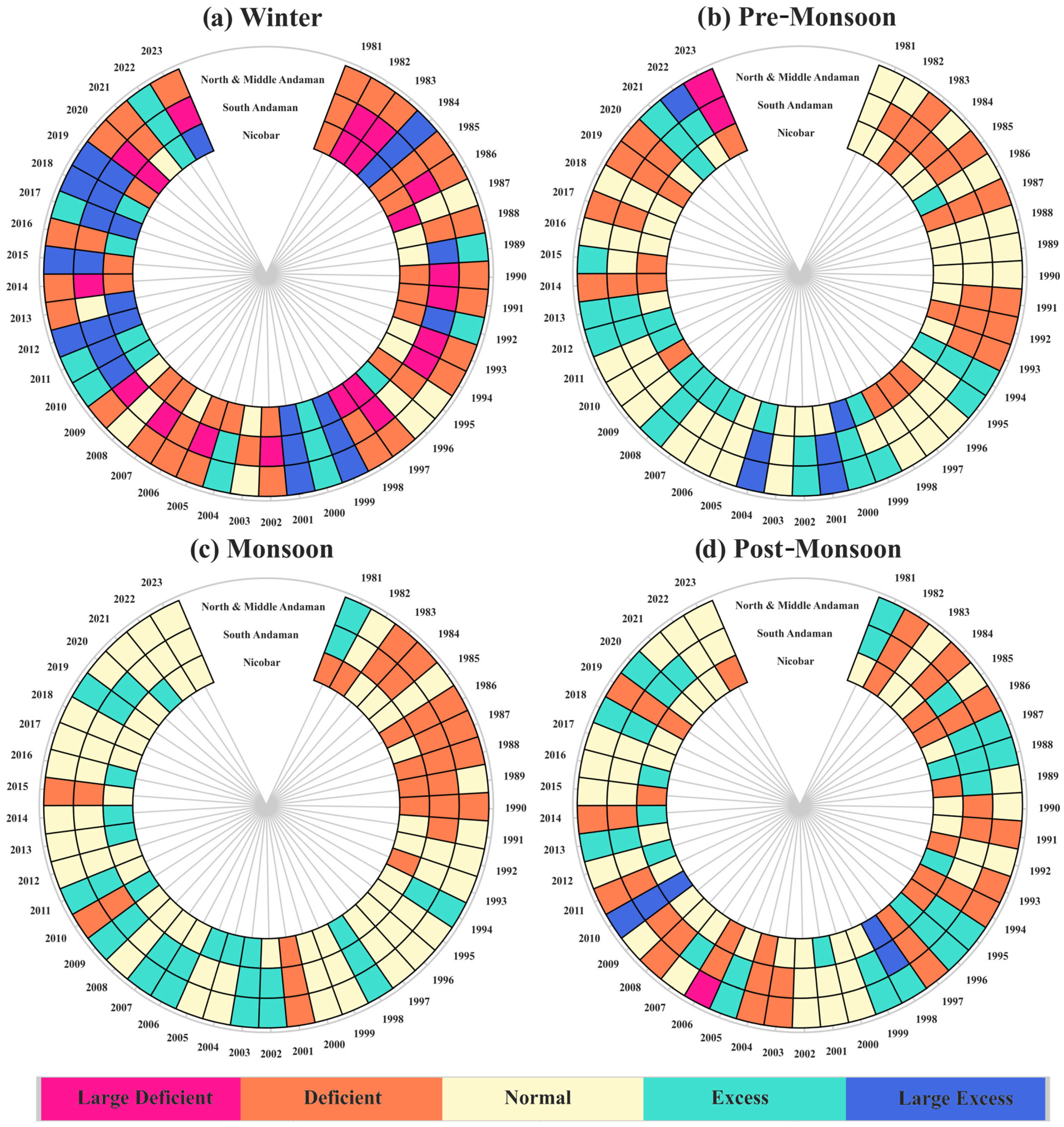
3.3. Precipitation Categorization

The year-wise categorization of seasonal precipitation in this research is based on the India Meteorological Department (IMD) classification, which divides precipitation into five categories: large deficient, deficient, normal, excess, and large excess. This study analyses these precipitation categories across three districts—Nicobar, North and Middle Andaman, and South Andaman—during the period 1981–2023. Figure 4 provides a detailed breakdown of the frequency of different precipitation categories across the three districts during the study period.
The statistics reveal notable variations in the frequency of each category across the winter, pre-monsoon, monsoon, and post-monsoon seasons, highlighting the unique climatic behaviour in these districts. In the winter season, Nicobar experienced predominantly deficient precipitation (15 years), along with occasional occurrences of excess (7 years) and large excess (7 years). Large deficient events occurred six times, indicating frequent dry spells. North and Middle Andaman recorded the highest frequency of deficient precipitation (23 years), with moderate occurrences of excess (8 years) and large excess (7 years). No large deficient events were observed, implying minimal extreme dryness. South Andaman experienced large deficient precipitation most frequently (15 years), followed by deficient precipitation (9 years). Normal precipitation was recorded only four times. Excess precipitation was rare (3 years), and large excess precipitation occurred 12 times, indicating a strong tendency toward extremely wet conditions during winter despite frequent dry spells. The predominance of deficient precipitation in Nicobar reflects the strong variability driven by localized factors, as noted by Kumar et al. [25]. The pre-monsoon season in Nicobar was dominated by normal precipitation (20 years), with deficient and excess precipitation recorded equally (11 years each). Large excess precipitation was rare, occurring only once, indicating limited extremes. North and Middle Andaman exhibited similar trends, with 19 years of normal precipitation. Deficient and excess precipitation were recorded 10 times each, while large deficient and large excess events were rare, with 1 and 3 occurrences, respectively. South Andaman saw 20 years of normal precipitation, accompanied by 12 years of deficient precipitation. Excess precipitation occurred eight times, with only one large deficient and two large excess events observed, indicating limited extreme variability. These trends reflect the transitional atmospheric conditions typical of the pre-monsoon season, as described by Adamala and Velmurugan [1]. These findings suggest that normal precipitation predominates due to the gradual buildup of moisture from increasing sea surface temperatures, which stabilizes precipitation patterns during this season.
During the monsoon season, Nicobar received normal precipitation for 26 years, with occasional occurrences of deficient (8 years) and excess (9 years) precipitation. No large deficient or large excess events were recorded, indicating stable monsoonal precipitation. Similarly, North and Middle Andaman experienced 24 years of normal precipitation, along with 9 years of deficient precipitation and 10 years of excess precipitation. No large deficient or large excess events were reported, reflecting consistent precipitation patterns during the monsoon. In South Andaman, monsoon precipitation was also stable, with 21 years of normal precipitation and 11 years each of deficient and excess precipitation, and no large deficient or large excess events were observed. This stability aligns with Sharma et al. [43], who emphasized that the consistency of monsoonal precipitation in India, specifically in the Tapi Basin region, is driven by strong monsoon currents and the absence of disruptive weather systems during this period.
In the post-monsoon season, Nicobar recorded normal precipitation for 21 years, with 13 years categorized as deficient. Excess precipitation was observed seven times, while large excess precipitation occurred twice, and no large deficient events were reported. In North and Middle Andaman, 17 years of normal precipitation were accompanied by 13 years of deficient precipitation and 11 years of excess precipitation. Large deficient and large excess events were infrequent, with only one occurrence each. South Andaman displayed higher variability, with 14 years of excess precipitation compared to 12 years of normal precipitation. Deficient precipitation occurred 15 times, and two large excess events were recorded, while no large deficient events were observed, reflecting some fluctuations during the post-monsoon season. The heightened variability in the post-monsoon season, particularly in South Andaman, mirrors findings from Sridhar and Pai [24], who attributed such fluctuations to sporadic cyclonic activities in the Bay of Bengal. This variability underscores the challenges in managing water resources during this season, as reservoirs often face inconsistent recharge levels.

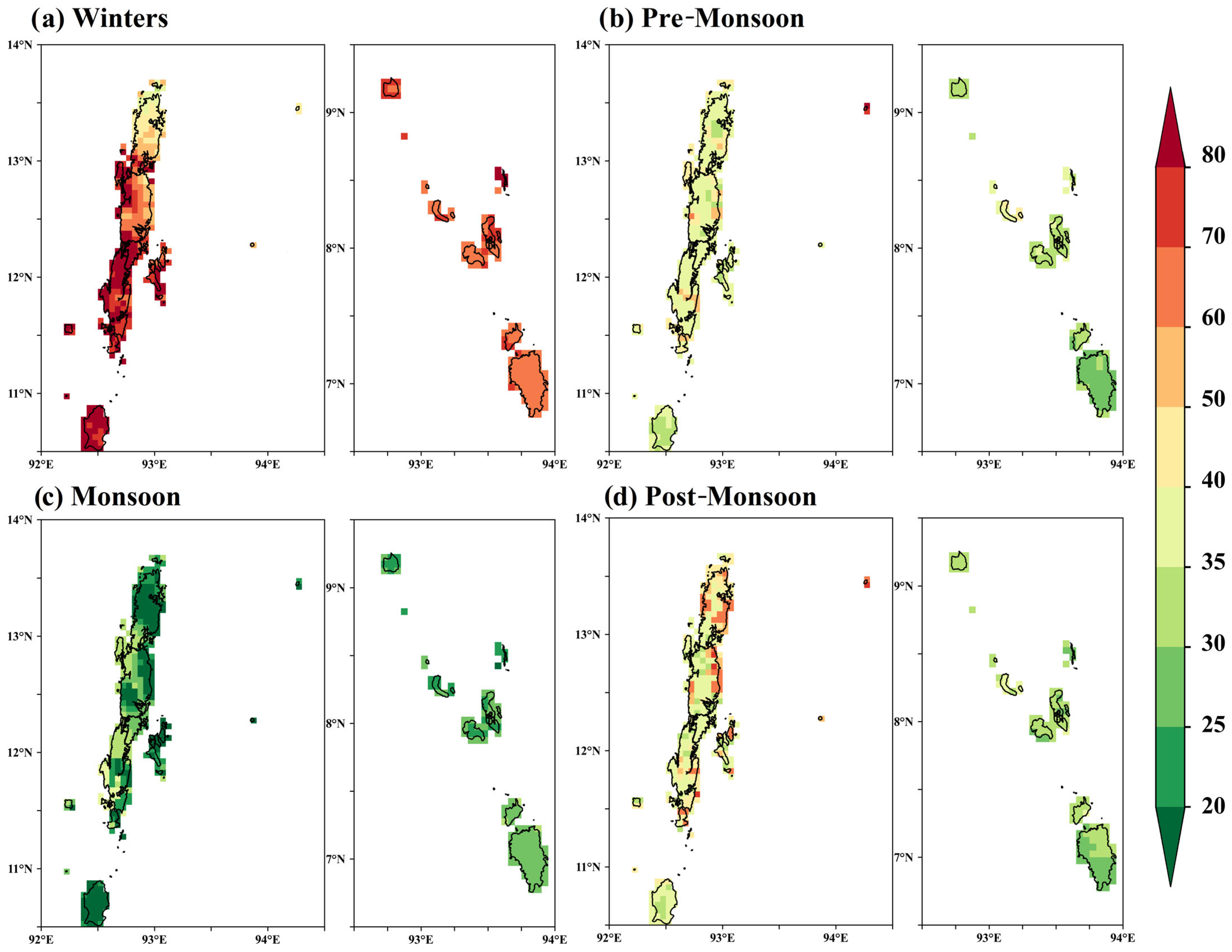
3.4. Seasonal Precipitation Trends

During the winter season from 1981 to 2023, precipitation trends across the Andaman and Nicobar Islands exhibited notable spatial variability, as depicted in Figure 5a.
During the pre-monsoon season, precipitation trends demonstrated considerable spatial variation, as shown in Figure 5b. The South Andaman district had the highest mean precipitation trend of 4.03 mm/year, with values ranging from 1.32 mm/year to 7.34 mm/year. This significant upward trend in South Andaman is in line with observations made by Adamala and Velmurugan [1], who reported increased pre-monsoon precipitation in this tropical island region due to shifts in the Intertropical Convergence Zone (ITCZ). The North and Middle Andaman district recorded a mean trend of 3.14 mm/year, with individual grid values ranging from −0.01 mm/year to 6.53 mm/year, indicating a mix of increasing and marginally decreasing trends. Conversely, the Nicobar district showed a negative mean precipitation trend of −0.06 mm/year, with pixel-level values ranging from −0.89 mm/year to 2.35 mm/year, indicating slight reductions in precipitation in some areas. Significance analysis based on the Mann–Kendall test found no grids with significant trends at the 99% confidence interval, while 5.97% of grids across the Andaman Islands displayed significance at the 95% confidence level. None of the grids in the Nicobar group exhibited statistically significant trends at either confidence interval.
Precipitation trends during the monsoon season revealed marked spatial variability, as depicted in Figure 5c. The Nicobar district had a mean trend of 6.54 mm/year, with values ranging from 2.59 mm/year to 12.66 mm/year, indicating moderate increases. In the North and Middle Andaman district, the mean trend was higher at 9.35 mm/year, with values spanning from −1.11 mm/year to 21.55 mm/year, reflecting substantial variability, including isolated negative trends. The higher variability observed in North and Middle Andaman is consistent with the findings of Shankar et al. [3], who noted that the presence of cyclonic disturbances significantly influences precipitation fluctuations in the region. The South Andaman district recorded the highest mean trend at 11.10 mm/year, with pixel-wise trends ranging from 2.20 mm/year to 28.23 mm/year, indicating significant increases. Trend significance analysis revealed that 16.71% of grids across the islands were significant at the 99% confidence interval, while 36.52% showed significance at the 95% confidence interval. In the Andaman group, 13.84% and 28.4% of grids were significant at the 99% and 95% levels, respectively, whereas in the Nicobar group, 2.86% and 7.88% of grids reached these thresholds.
Post-monsoon precipitation trends also exhibited spatial variability, as illustrated in Figure 5d. The Nicobar district recorded the highest mean trend at 2.90 mm/year, with pixel-level values ranging from 1.38 mm/year to 4.10 mm/year, indicating consistent increases. The North and Middle Andaman district had a mean trend of 0.51 mm/year, with values ranging from 0.05 mm/year to 1.39 mm/year, while the South Andaman district recorded the lowest mean trend at 0.44 mm/year, with values ranging from 0.02 mm/year to 1.76 mm/year. Significance analysis indicated that 2.63% of grids across the islands were significant at the 99% confidence interval, while 26.97% were significant at the 95% level. In the Andaman group, 0.72% and 7.88% of grids exhibited trends significant at 99% and 95% confidence levels, respectively, while the Nicobar group had 1.91% and 18.85% of grids showing significant trends at the same thresholds.

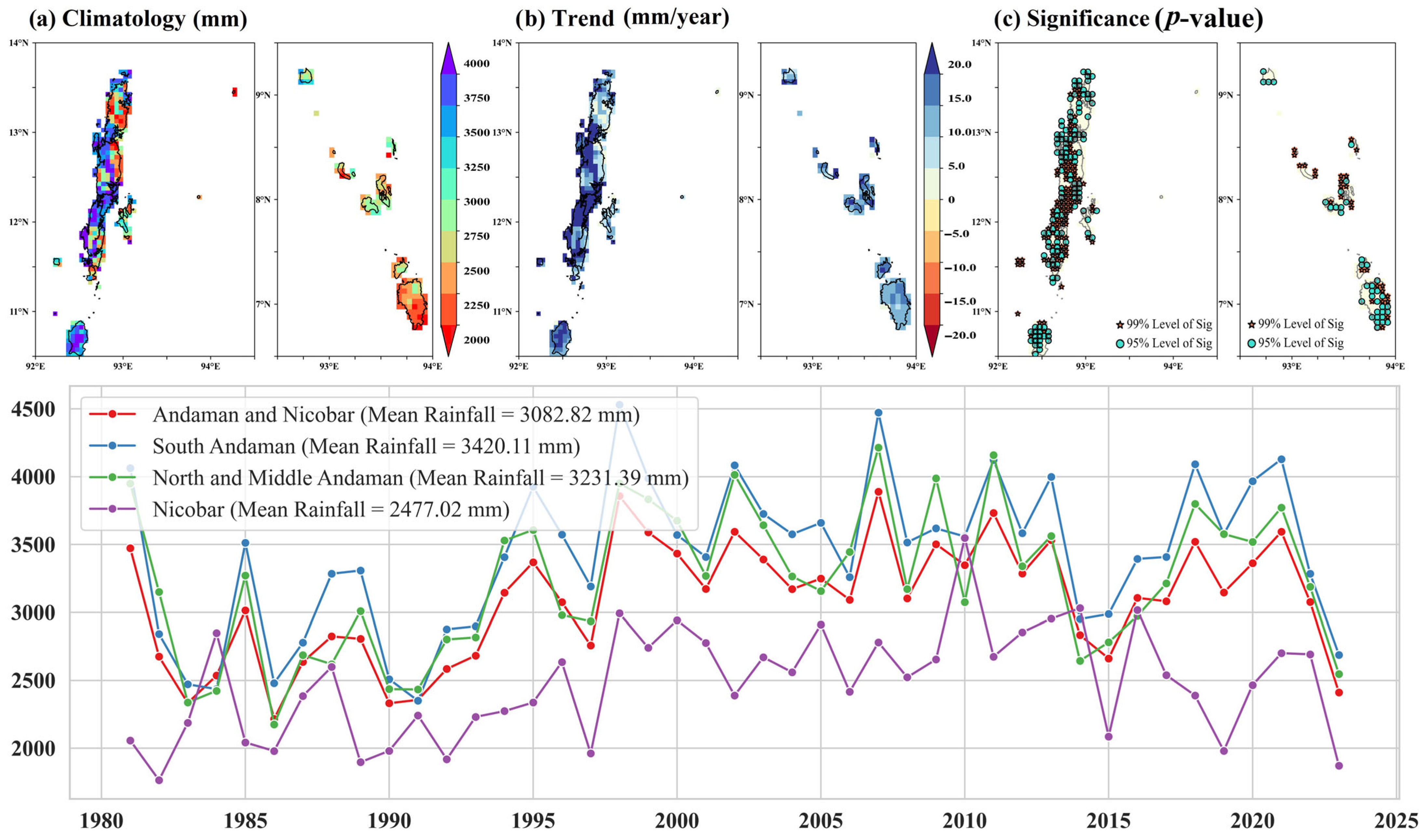
3.5. Annual Precipitation Trends (PRCPTOT)

Figure 6 illustrates the spatial distribution of (a) mean annual precipitation (PRCPTOT) in mm, representing precipitation climatology, (b) Sen’s slope (mm/year), indicating precipitation trends, and (c) the p-value of the Mann–Kendall test, indicating the statistical significance of these trends, along with the temporal variability of annual precipitation for 1981–2023 in the Andaman and Nicobar Islands.
The spatial distribution of mean total annual precipitation (PRCPTOT) across the Andaman and Nicobar Islands revealed distinct climatological patterns. The Nicobar district received an average annual precipitation of 2442.7 mm, ranging from 1961.3 mm to 3370.8 mm. In North and Middle Andaman, precipitation was higher, averaging 3192.4 mm annually, with values between 1865.2 mm and 4679.0 mm. South Andaman recorded the highest mean precipitation at 3447.7 mm, with totals varying from 2025.9 mm to 4620.7 mm. The trend analysis of PRCPTOT using Sen’s slope highlighted precipitation changes across the region. The Nicobar district showed a mean trend of 14.2 mm/year, with pixel-wise values ranging from 7.7 mm/year to 21.8 mm/year. North and Middle Andaman exhibited a slightly higher mean trend of 16.0 mm/year, with trends spanning 2.1 mm/year to 31.6 mm/year. South Andaman showed the highest mean trend of 18.3 mm/year, with values between 5.8 mm/year and 34.6 mm/year. These trends demonstrate spatial variability and a tendency towards increased precipitation across the region. Across the islands, 29.83% of grids showed statistically significant trends in PRCPTOT at the 99% confidence interval, while 36.75% were significant at the 95% confidence interval. In the Andaman group, 23.15% and 27.68% of grids showed significant trends at the 99% and 95% levels, respectively, while in Nicobar, 6.68% and 8.83% of grids were significant at these levels. The variable trends align with the observations made by Adamala and Velmurugan [1], who concluded that South-West, North-East, and post-monsoon precipitation showed a non-significant decreasing trend at the rate of 0.05, 0.55 and 0.03 mm year−1, respectively, while the summer and pre-monsoon months showed an increasing trend at 0.16 and 0.25 mm year−1, respectively.

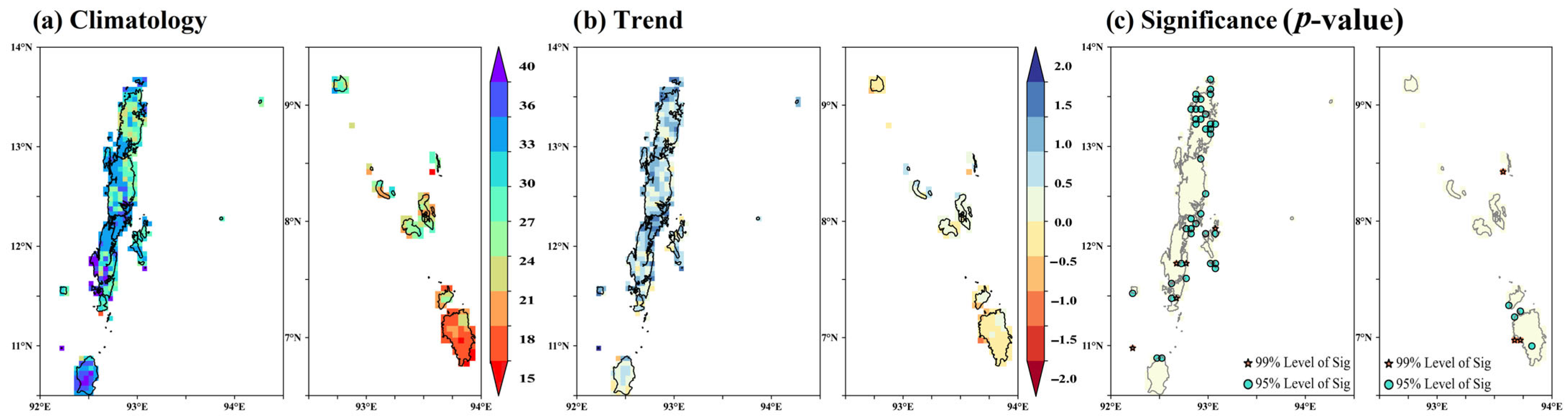
3.6. Total Annual Rainy Days

The spatial distribution of the mean annual number of rainy days across the Andaman and Nicobar Islands revealed distinct climatological patterns. The Nicobar district experienced the highest average of 132.22 rainy days per year, ranging from 102.74 to 143.53 days, reflecting consistently high precipitation activity. In North and Middle Andaman, the average was 107.52 rainy days per year, varying between 78.30 and 120.09 days, indicating moderate spatial variability. The South Andaman district recorded an annual average of 106.66 rainy days, ranging from 75.58 to 120.19 days. The analysis of Sen’s slope trends in annual rainy days showed spatial variability in the rate of change across the islands. The Nicobar district exhibited a mean increase of 9.02 days per decade, with trends ranging from 4.74 to 12.00 days per decade, indicating substantial increases in precipitation frequency. North and Middle Andaman showed a modest mean increase of 2.17 days per decade, with trends ranging from −1.21 to 5.00 days per decade, reflecting localized decreases in some areas. The South Andaman district showed a mean increase of 3.69 days per decade, with trends between 0.00 and 6.15 days per decade, reflecting relatively uniform increases. Sharma et al. [43] similarly highlighted the uneven nature of precipitation increases over Tapi Basin, which are not always consistent across regions. Across the Andaman and Nicobar Islands, 44.63% of grids showed statistically significant trends in annual rainy days at the 99% confidence level, while 26.97% were significant at the 95% level. In the Andaman group, 21.24% and 24.34% of grids showed significant trends at the 99% and 95% levels, respectively. In the Nicobar group, 23.15% of grids were significant at the 99% level, while 2.63% were significant at the 95% level. These results are contradictory to the results of study conducted by [24], which concluded that there was a decreasing trend in yearly rainy days with a significant trend over all the stations except Port Blair during 1961–2000. This might be due to the change in the analysis year and variation in the classification of the study area. Figure 7 depicts the spatial distribution of (a) mean annual rainy days, representing the climatology of rainy days per year, (b) Sen’s slope (days/decade), indicating trends in rainy days, and (c) the p-value of the Mann–Kendall test, indicating the statistical significance of these trends, along with the temporal variability of annual rainy days for 1981–2023 in the Andaman and Nicobar Islands.

3.7. Intensity-Based Indices

The climatology of annual light precipitation (2.5 mm to 15.5 mm) days, depicted in Figure 8a (row 1), shows variation across the Andaman and Nicobar Islands.
In Nicobar, the average was 69.28 days, with a range of 38.40 to 88.35 days. North and Middle Andaman experienced an average of 40.01 days, ranging from 28.37 to 50.63 days, while South Andaman recorded 36.43 days on average, with values between 23.53 and 49.98 days. This variation is consistent with previous findings by [24], who observed similar spatial differences in precipitation patterns across the island. The Sen’s slope trend of annual light precipitation days, shown in Figure 8b (row 1), reveals that Nicobar had a mean increase of 4.32 days per decade, ranging from 0.63 to 7.22 days, indicating a moderate rise in light precipitation. North and Middle Andaman showed a slight increase of 0.07 days per decade, with values ranging from −2.59 to 2.63 days, suggesting localized decreases. In South Andaman, the mean trend was 0.76 days per decade, with values ranging from −1.11 to 2.37 days, indicating moderate increases but also some localized decreases. This trend of increasing rainy days is supported by the study of [1], who also identified a rise in rainy days events over the region. Statistically, 13.37% of grids across the Andaman and Nicobar Islands exhibited significant trends at the 99% confidence interval, and 8.59% at the 95% confidence interval. In the Andaman group of islands, 0.24% of grids showed significant trends at the 99% level, and 2.39% at the 95% level. In contrast, Nicobar showed 13.13% of grids with significant trends at the 99% confidence level and 5.97% at the 95% level.
The climatology of annual moderate precipitation (15.6 mm to 64.4 mm) days, illustrated in Figure 8a (row 2), displays regional variation. Nicobar had an average of 48.97 days, ranging from 41.77 to 60.40 days, while North and Middle Andaman had 50.41 days, with values ranging from 33.74 to 63.67 days, and South Andaman exhibited 50.31 days, ranging from 35.72 to 60.14 days. The Sen’s slope trend for these days, shown in Figure 8b (row 2), indicates that Nicobar’s trend increased by 2.76 days per decade, with a range of 1.38 to 4.67 days. North and Middle Andaman showed a trend of 0.95 days per decade, with values ranging from −0.77 to 3.33 days. South Andaman showed a mean increase of 1.20 days per decade, ranging from −0.38 to 3.33 days, showing both an increase and some localized decreases. Statistically, 12.65% of grids across the Andaman and Nicobar Islands exhibited significant trends at the 99% confidence level, and 23.63% at the 95% confidence level. In the Andaman group of islands, 5.25% of grids exhibited significant trends at the 99% level, and 11.93% at the 95% level. In contrast, Nicobar showed 7.16% of grids with significant trends at the 99% confidence level and 11.69% at the 95% level.
In terms of heavy precipitation days (64.5 mm to 115.5 mm), the Nicobar district recorded an average of 4.06 days, ranging from 2.10 to 9.55 days. North and Middle Andaman had an average of 8.28 days, ranging from 4.34 to 12.58 days, while South Andaman showed the highest average of 9.34 days, ranging from 5.26 to 13.25 days. Figure 8a (row 3) reveals these spatial disparities. The Sen’s slope trend for heavy precipitation days, shown in Figure 8b (row 3), highlights a mean trend of 0.10 days per decade in Nicobar, with a range from −0.45 to 1.17 days per decade. North and Middle Andaman showed a stronger positive trend, with a mean of 0.55 days per decade and a range from 0.00 to 1.53 days. South Andaman experienced the steepest increase, with a mean trend of 0.87 days per decade, ranging from 0.00 to 2.08 days. These trends suggest more frequent heavy precipitation events, especially in South Andaman. Across the Andaman and Nicobar Islands, 14.8% of grids showed significant trends at the 99% confidence interval, and 16.95% at the 95% confidence level. In the Andaman Islands, 13.84% of grids showed significant trends at the 99% confidence interval, and 15.75% at the 95% confidence level. In contrast, Nicobar recorded only 0.72% of grids showing significant trends at the 99% confidence level and 1.19% at the 95% level.
The climatology of very heavy precipitation days (greater than 115.6 mm), depicted in Figure 8a (row 4), demonstrates distinct spatial variations. Nicobar averaged 1.50 days per year, ranging from 1.00 to 2.50 days, while North and Middle Andaman experienced a higher mean of 3.41 days, ranging from 1.15 to 7.14 days. South Andaman recorded the highest mean, with 4.16 days per year, ranging from 1.27 to 9.06 days. The trend of very heavy precipitation days, shown in Figure 8b (row 4), suggests minimal change in Nicobar, with a mean trend of 0.01 days per decade (ranging from 0.00 to 0.33 days). North and Middle Andaman exhibited a higher trend of 0.04 days per decade, ranging from −0.32 to 0.50 days. South Andaman had the most pronounced trend, with a mean of 0.09 days per decade, ranging from −0.43 to 1.25 days, indicating substantial increases in specific areas. For very heavy precipitation days, 0.48% of grids across the Andaman and Nicobar Islands exhibited statistically significant trends at the 99% confidence level, and 3.58% at the 95% confidence level. In the Andaman Islands, 0.48% and 2.63% of grids showed significant trends at the 99% and 95% confidence intervals, respectively. In Nicobar, no grids showed significant trends at the 99% confidence level, but 0.95% exhibited significance at the 95% level.

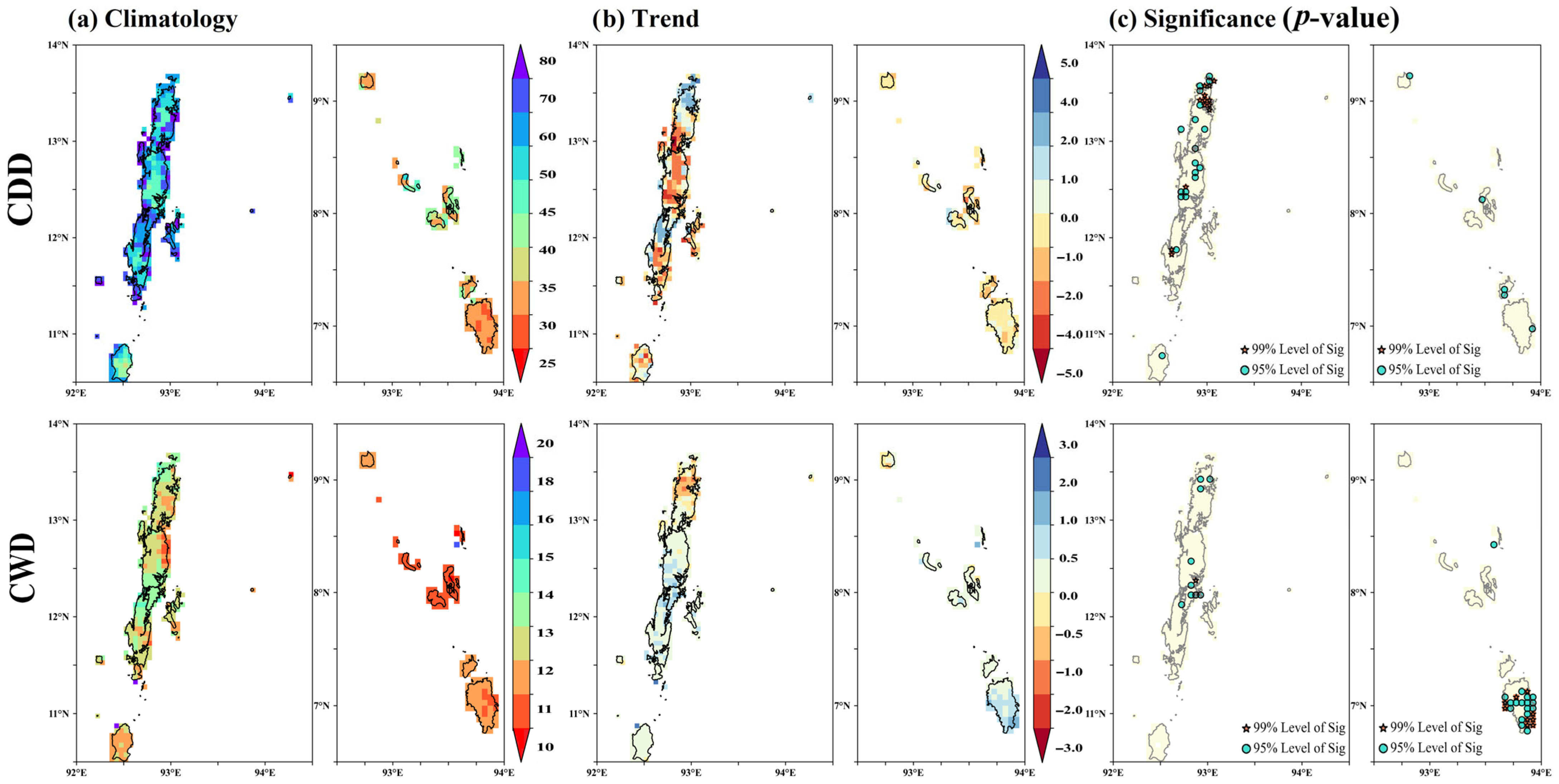
3.8. Persistence and Duration Indices (CDDs and CWDs)

The climatology of the maximum length of dry spell (CDD) in the Andaman and Nicobar Islands showed significant spatial variation. In the Nicobar district, the mean CDD value was 33.31 days, ranging from 29.00 to 50.27 days, indicating shorter dry spells compared to other districts. In the North and Middle Andaman district, the mean CDD value was 61.61 days, spanning 44.76 to 86.60 days, reflecting the occurrence of more extended dry periods. Similarly, the South Andaman district had a mean CDD value of 61.28 days, varying from 38.34 to 86.16 days. These findings highlight that North and Middle Andaman and South Andaman experienced longer dry spells on average compared to the Nicobar district, underscoring distinct climatic patterns across the region. The increasing trend in dry spells observed here is consistent with the findings of [43], who identified a general rise in the frequency of dry periods in island regions. Trends in the maximum number of consecutive dry days (CDDs) showed notable regional variability in Sen’s slope estimates. In the Nicobar district, the mean trend in CDDs was −0.63 days per decade, with values ranging from −2.10 to 1.15 days, indicating an overall decrease in dry spell length, though some areas showed slight increases. The North and Middle Andaman district had a mean trend of −0.78 days per decade. A spatial analysis revealed that 3.1% of grids in the Andaman and Nicobar Islands showed statistically significant trends at the 99% confidence interval, while 5.73% were significant at the 95% interval. In the Andaman group, 3.1% of grids were significant at 99% confidence, with 4.53% significant at 95%. In the Nicobar group, no grids were significant at 99%, and 1.19% showed significance at 95%.
The climatology of the maximum length of wet spell (CWD) in the Andaman and Nicobar Islands showed regional differences. In the Nicobar district, the mean CWD value was 11.02 days, ranging from 10.02 to 11.79 days, indicating shorter wet periods. In contrast, the North and Middle Andaman district had a higher mean of 12.65 days, with values between 10.46 and 14.06 days, while the South Andaman district had a mean of 12.39 days, ranging from 11.04 to 14.11 days. These differences highlight longer wet spells in the North and Middle Andaman and South Andaman districts compared to the Nicobar district. The trends in CWD reveal varied patterns of change. In the Nicobar district, the mean Sen’s slope was 0.32 days per decade, with values from −0.55 to 1.25 days per decade, showing a slight increase in wet spells, though some areas exhibited declines. The North and Middle Andaman district showed a mean slope of 0.01 days per decade, with trends ranging from −1.20 to 1.11 days per decade, suggesting minimal changes overall, though there were areas with both increases and decreases. The variability in these trends corresponds with the findings of Sharma et al. [43], who observed a decrease in wet days over the Indian region, specifically over Tapi Basin. In South Andaman, the mean slope was 0.17 days per decade, with values ranging from −0.28 to 1.03 days per decade, indicating a general trend toward longer wet spells in some areas, despite a few negative trends. These varying trends demonstrate spatial variability in changing wet spell patterns across the islands. In the Andaman and Nicobar Islands, 2.39% of grids showed statistically significant trends at the 99% confidence interval, and 6.44% at the 95% confidence interval. In the Andaman group, 0.24% of grids were significant at the 99% level, and 2.15% at the 95% level, while in the Nicobar group, 2.15% of grids were significant at the 99% level and 4.06% at the 95% level. Figure 9 presents the spatial distribution of (a) the mean annual maximum length of dry spell (CDD) and wet spell (CWD), representing the climatology of consecutive wet days (>2.5 mm precipitation) and consecutive dry days (<2.5 mm precipitation), respectively; (b) Sen’s slope (days/decade), indicating trends in CDDs and CWDs; and (c) the p-value of the Mann–Kendall test, indicating the statistical significance of these trends for 1981–2023 in the Andaman and Nicobar Islands.

3.9. Magnitude and Distribution Indices (Rx1day, Rx5day, and SDII)

The annual maximum 1-day precipitation (Rx1day) across the Andaman and Nicobar Islands showed notable spatial variability. In the Nicobar district, the mean Rx1day was 111.88 mm, ranging from 74.40 mm to 170.65 mm, indicating moderate precipitation intensities during the wettest day each year. In the North and Middle Andaman district, the mean Rx1day was 180.10 mm, ranging from 104.39 mm to 305.47 mm, reflecting significantly higher precipitation intensities. The South Andaman district recorded the highest mean Rx1day of 209.39 mm, with values from 114.38 mm to 308.69 mm, signifying more intense precipitation events. These variations highlight pronounced spatial differences in extreme precipitation, with the South Andaman district experiencing the highest intensities. Trends in annual Rx1day reveal varied changes over time. In the Nicobar district, the mean Sen’s slope was −0.63 mm per decade, with trends ranging from −7.79 mm to 8.91 mm per decade, reflecting both decreases and increases in extreme precipitation. The North and Middle Andaman district showed a mean Sen’s slope of 3.66 mm per decade, with a range of −6.63 mm to 14.25 mm, indicating a general tendency for increasing precipitation intensities. The South Andaman district had a mean slope of 1.13 mm per decade, with trends from −12.21 mm to 19.48 mm per decade, highlighting substantial spatial variability with significant increases and notable declines in some areas. These trends emphasize the heterogeneity in changing precipitation patterns across the region. Statistical analysis revealed that 1.43% of grids in the Andaman and Nicobar Islands showed significant trends at the 99% confidence level, and 6.68% were significant at the 95% level. In the Andaman group, 0.48% of grids were significant at the 99% level, and 4.06% at the 95% level. In the Nicobar group, 0.95% showed significance at the 99% level, and 2.39% at the 95% level. Sridhar and Pai [24] observed similar trends of spatial heterogeneity in extreme precipitation events over the Andaman and Nicobar Islands, emphasizing that variations are strongly influenced by localized topography and mesoscale weather systems. These findings reinforce the higher Rx1day values reported for the South Andaman district, which is characterized by its proximity to the Bay of Bengal and its vulnerability to cyclonic systems. Sharma et al. [43] noted the importance of recognizing spatial variability when indicating extreme precipitation trends, as certain areas exhibit statistically significant trends while others do not, a phenomenon observed across the Andaman and Nicobar Islands. Figure 10 illustrates the spatial distribution of (a) the mean annual maximum 1-day precipitation (Rx1day) and wettest consecutive 5-day precipitation periods, respectively, representing the climatology of the highest daily precipitation each year; (b) Sen’s slope (mm/decade), indicating trends in Rx1day and Rx5day; and (c) the p-value of the Mann–Kendall test, indicating the statistical significance of these trends for 1981–2023 in the Andaman and Nicobar Islands.
In the Nicobar district, the mean Rx5day was 280.42 mm, ranging from 195.62 mm to 397.33 mm, reflecting moderate precipitation totals over the wettest five-day periods. In the North and Middle Andaman district, the mean increased to 424.29 mm, with a range of 258.51 mm to 672.52 mm, indicating more intense precipitation events. The South Andaman district recorded the highest mean of 485.08 mm, varying between 286.68 mm and 697.83 mm, highlighting extremely intense precipitation during consecutive days. These differences indicate distinct spatial variability, with the South Andaman district experiencing the most substantial cumulative precipitation. Trends in Rx5day reveal notable temporal variability. In the Nicobar district, the mean Sen’s slope was 4.52 mm per decade, ranging from −14.33 mm to 27.74 mm, indicating a mix of declining and rising precipitation intensities. The North and Middle Andaman district showed a higher mean Sen’s slope of 14.98 mm per decade, with values between −18.13 mm and 36.93 mm, reflecting a tendency toward increasing multi-day precipitation totals, although some areas exhibited decreasing trends. The South Andaman district had a mean Sen’s slope of 3.49 mm per decade, with the widest range from −32.00 mm to 52.52 mm, showing both significant increases and decreases in precipitation intensities. These observations emphasize the heterogeneous nature of Rx5day trends across the region, with spatially varied patterns of change. Statistical analysis of trends further highlighted spatial variability. Out of 419 grids analysed, 1.67% exhibited statistically significant trends at the 99% confidence level, and 6.21% were significant at the 95% level. In the Andaman group of islands, which includes 309 grids, 1.43% showed significant trends at the 99% confidence level, and 5.01% were significant at the 95% level. In the Nicobar group of islands, out of 109 grids, 0.24% displayed significant trends at the 99% level, and 1.19% were significant at the 95% level. The increasing frequency and magnitude of extreme precipitation events observed in other regions, as reported by Sharma et al. [43], have been linked to factors such as rising maximum and minimum temperatures, declining forest cover, rapid urbanization, population growth, and increased atmospheric aerosol content.
The annual simple precipitation intensity index (SDII) showed distinct spatial variation across the Andaman and Nicobar Islands, reflecting precipitation intensity on wet days. Figure 11 shows the spatial distribution of (a) the mean annual simple precipitation intensity index (SDII), representing the climatology of precipitation intensity on wet days (≥2.5 mm); (b) Sen’s slope (mm/decade), indicating trends in SDII; and (c) the p-value of the Mann–Kendall test, indicating the statistical significance of these trends for 1981–2023 in the Andaman and Nicobar Islands.
In the Nicobar district, the mean SDII was 20.08 mm, ranging from 14.84 mm to 28.96 mm, indicating moderate precipitation intensity. The North and Middle Andaman district displayed a higher mean of 30.90 mm, varying between 22.33 mm and 40.16 mm, indicating more substantial precipitation rates. The South Andaman district recorded the highest mean SDII of 34.19 mm, with values spanning from 23.97 mm to 46.09 mm, highlighting intense precipitation events. These observations reveal a gradient in precipitation intensity, with the South Andaman district experiencing the most intense precipitation, followed by North and Middle Andaman and the Nicobar district, which exhibited relatively moderate wet day precipitation rates. These findings align with [24], who also observed considerable variability in extreme precipitation events over the Andaman and Nicobar Islands, indicating an increasing trend in extreme precipitation events in certain areas. Trends in SDII, represented by Sen’s slope, exhibit notable spatial variation across the Andaman and Nicobar Islands. In the Nicobar district, the mean trend was −0.09 mm per decade, with values ranging from −0.64 mm to 0.82 mm per decade, reflecting a mix of declining and marginally increasing precipitation intensities on wet days. The North and Middle Andaman district showed a positive mean trend of 0.84 mm per decade, with values ranging from −0.47 mm to 1.79 mm per decade, indicating a general tendency toward increasing precipitation intensity but with some localized declines. The South Andaman district recorded a mean trend of 0.62 mm per decade, with trends varying from −0.41 mm to a substantial increase of 2.23 mm per decade, signifying heterogeneous changes in wet day precipitation intensities. The spatially heterogeneous trends observed in SDII are consistent with the findings of Sharma et al. [43], who reported variability in extreme precipitation indices across different regions in India, including both positive and negative trends depending on localized climatic conditions. The statistical analysis of SDII trends revealed varying levels of significance across the Andaman and Nicobar Islands.

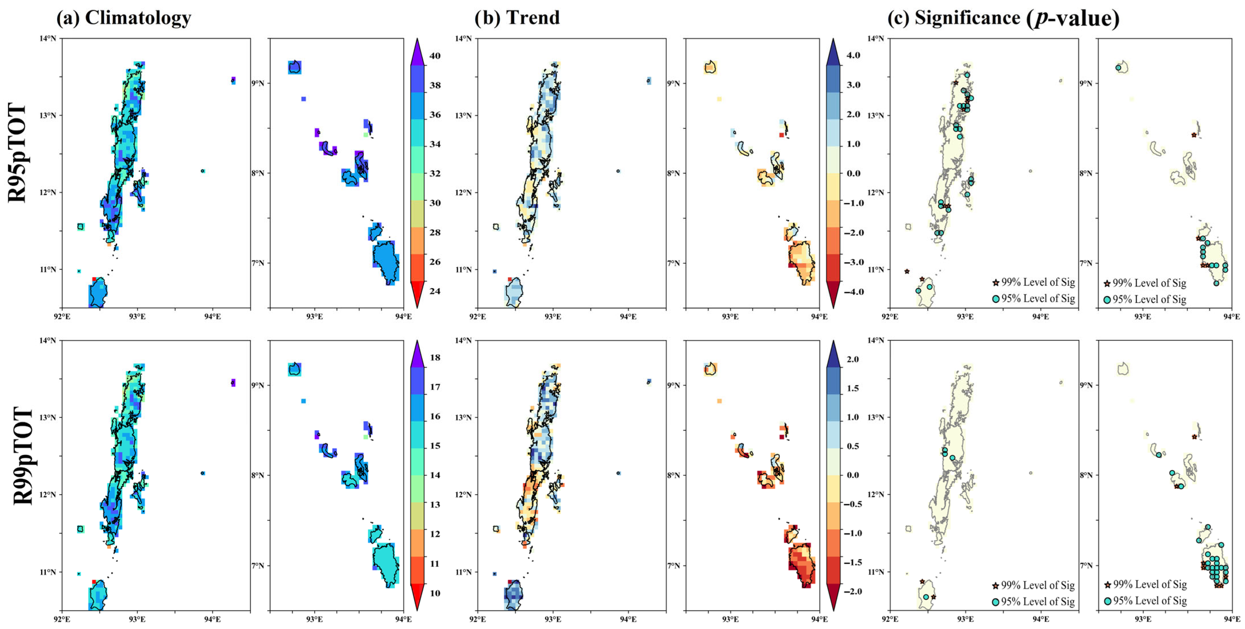
3.10. Percentile Threshold Indices (R95pTOT and R99pTOT)

The climatology of annual total precipitation, when daily precipitation exceeds the 95th percentile (R95pTOT), highlights the contribution of very wet days to total precipitation across the Andaman and Nicobar Islands. Figure 12 presents the spatial distribution of (a) the mean annual total precipitation on very wet days (R95pTOT) and extremely wet days (R99pTOT), representing the climatology of precipitation contribution from days exceeding the 95th percentile and 99th percentile, respectively; (b) Sen’s slope (mm/decade), indicating trends in R95pTOT and R99pTOT; and (c) the p-value of the Mann–Kendall test, indicating the statistical significance of these trends for 1981–2023 in the Andaman and Nicobar Islands.
In the Nicobar district, the mean R95pTOT was 37.35%, ranging from 36.30% to 40.22%, indicating a significant contribution from extreme precipitation events. In the North and Middle Andaman district, the mean R95pTOT was 35.42%, with values ranging from 30.48% to 39.29%, showing slightly lower contributions from extreme events compared to the Nicobar district. The South Andaman district exhibited a mean of 36.68%, with values between 31.85% and 39.62%, reflecting a moderate contribution from very wet days. These findings align with [24], who noted significant spatial and temporal variations in extreme precipitation indices over the Andaman and Nicobar Islands. While this study highlights an overall increase in contributions from very wet days (R95pTOT) in the Andaman districts and a general decline in the Nicobar district, Velmurugan et al. [42] observed an increase in the heavy-to-very-heavy precipitation categories, ranging from 6.5% to 8.8%, compared to the climatic normal of 6.5%. This aligns with the increasing contribution of extreme precipitation events observed in the South Andaman and North and Middle Andaman districts, highlighting the growing prominence of extreme precipitation in the region. The trend analysis of R95pTOT provided insights into long-term variability in extreme precipitation contributions from 1981 to 2023. In the Nicobar district, the mean trend was −0.67% per decade, with a range from −2.54% to 1.50% per decade, suggesting a slight decline in contributions from very wet days. The North and Middle Andaman district showed a mean trend of 1.18% per decade, ranging from −0.93% to 3.53% per decade, indicating an overall increase in extreme precipitation contributions. The South Andaman district also showed a positive trend with a mean of 1.08% per decade, ranging from −0.92% to 4.03% per decade, reflecting increasing contributions from very wet days. These trends reveal a rise in the intensity and frequency of very wet days in the Andaman group, while the Nicobar district showed mixed results, including some declines. Shankar et al. [3] highlighted the vulnerability of the Andaman and Nicobar Islands to cyclones, which often contribute to excess precipitation and flooding in the region. Their study revealed that 14.49% of the coastline falls in the high-vulnerability category, emphasizing the compounded risks of extreme precipitation events and cyclone-induced flooding. Across the Andaman and Nicobar Islands, 2.86% of grids displayed statistically significant trends at the 99% confidence level, and 8.11% at the 95% level. In the Andaman group, 1.91% of grids had significant trends at the 99% level, with 5.25% at the 95% level, while in the Nicobar group, 0.95% of grids were significant at the 99% level, and 2.63% at the 95% level. These results correspond with the findings of Sharma et al. [43], who demonstrated that spatial variability in extreme precipitation trends is often governed by the interplay of large-scale climatic drivers and localized geographic influences.
In the Nicobar district, the mean R99pTOT was 15.89%, with values ranging from 15.21% to 17.73%, indicating that a significant proportion of precipitation originates from extremely wet days. The North and Middle Andaman district had a slightly lower mean R99pTOT of 15.54%, with a broader range from 13.26% to 17.99%, reflecting both reduced contributions and greater spatial variability in extreme precipitation events. The South Andaman district showed the highest mean R99pTOT at 16.04%, with values ranging from 14.00% to 17.42%, indicating a consistently strong influence of extremely wet days. This spatial heterogeneity aligns with findings by Sridhar and Pai [24], who noted significant variability in extreme precipitation patterns over the Andaman and Nicobar Islands, driven by both localized topography and synoptic weather systems. However, they also noted periods of significant decreases in extreme precipitation indices in the Nicobar group, potentially due to shifts in monsoonal patterns. In the Nicobar district, the mean trend was −0.99% per decade, ranging from −2.53% to 1.21%, showing a general decline in the contribution of extreme precipitation events, with some localized increases. The North and Middle Andaman district had a positive mean trend of 0.60% per decade, with values ranging from −1.47% to 2.50%, suggesting an overall increase, although some areas showed declines. The South Andaman district displayed a positive mean trend of 0.38% per decade, ranging from −1.41% to 2.59%, reflecting an overall increase in contributions from very wet days, with a few regions experiencing decreases. Across the Andaman and Nicobar Islands, 2.15% of grids showed statistically significant trends in R99pTOT at the 99% confidence interval, and 6.68% at the 95% confidence interval. Within the Andaman group, only 0.48% of grids showed significance at the 99% level, and 0.95% at the 95% level. In the Nicobar group, 1.67% of grids were significant at the 99% confidence interval, and 5.49% at the 95% level.

4. Conclusions

The study investigates the spatio-temporal variability of precipitation and its trends in the Andaman and Nicobar Islands, India, by utilizing high-resolution CHIRPS observational data. This analysis helps to understand how precipitation patterns fluctuate over time and space in this region, providing insights into changing climate trends. The key findings of the study are as follows:
  • Significant increasing trends in mean precipitation are found over most parts of Nicobar during the winter and post-monsoon seasons, as well as over most parts of Andaman during the monsoon season. Additionally, some parts of the islands exhibited increasing trends in mean precipitation during all other seasons. On an annual timescale, most parts of Andaman and Nicobar showed significant increasing trends in mean precipitation and the number of rainy days (precipitation ≥ 1 mm).
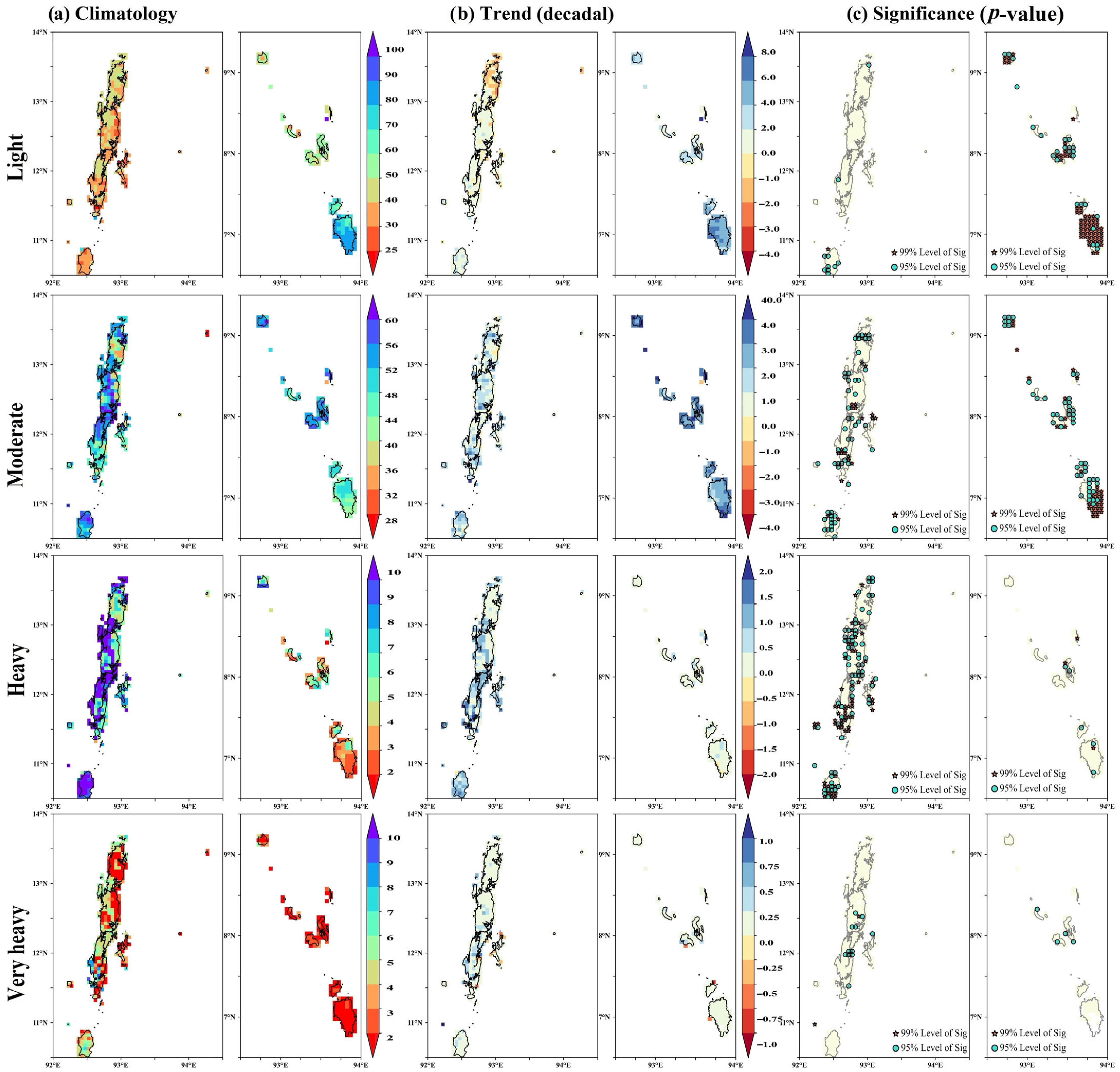
  • It is observed that the light-to-moderate precipitation events occur more frequently than heavy precipitation events across the islands, although heavy precipitation is more frequent in Andaman than in Nicobar.
  • A significant increase in the frequency of light-to-moderate precipitation (i.e., between 2.5 mm and 64.4 mm) events is noted across most of Nicobar, while parts of Andaman showed a rise in the frequency of moderate-to-heavy precipitation (i.e., between 64.4 mm and 115.5 mm) events. Additionally, some areas of central Andaman and Nicobar experienced a significant rise in the frequency of very heavy precipitation (precipitation ≥ 115.6 mm) events.
  • In general, Andaman experienced a higher intensity of extreme precipitation (i.e., Rx1day and Rx5day) compared to Nicobar, although only a few parts of Andaman (mostly in central Andaman) and Nicobar (mostly in southern Nicobar) showed increases in precipitation during both indices.
These findings underscore the growing vulnerability of the Andaman and Nicobar Islands to extreme precipitation events, influenced by local climate dynamics, topography, and possibly anthropogenic changes. The observed regional trends in the frequency and intensity of precipitation events highlight the need for region-specific climate adaptation and mitigation strategies, particularly in the areas of water resource management, agricultural planning, and disaster risk reduction in response to climate change-induced variability. The varying precipitation patterns and trends across the Andaman and Nicobar Islands emphasize the need for further investigation to better understand the underlying physical mechanisms driving these changes. This study also suggests assessing the fidelity of climate models to determine if they accurately represent observed precipitation variability and trends, as well as investigating projected future changes.

Author Contributions

Conceptualization, A. and N.K.S.; Data curation, A. and N.K.S.; Formal analysis, A.; Methodology, A.; Resources, A., T.H., T.S., I.J. and N.K.S.; Software, A.; Supervision, A.S. and N.K.S.; Validation, A., A.S. and N.K.S.; Visualization, A. and A.S.; Writing—original draft, A. and A.S.; Writing—review and editing, A.S., T.H. and N.K.S. All authors have read and agreed to the published version of the manuscript.

Funding

This research received no external funding.

Institutional Review Board Statement

Not applicable.

Informed Consent Statement

Not applicable.

Data Availability Statement

The daily CHIRPS, Precipitation Estimates from Rain Gauge and Satellite Observations, used to conduct this study is openly available at https://www.chc.ucsb.edu/data/chirps (accessed on 18 January 2025).

Acknowledgments

The authors express their sincere gratitude to the Director of the ICAR-Central Island Agricultural Research Institute (ICAR-CIARI) for providing the essential facilities and support required to carry out this research.

Conflicts of Interest

The authors declare no conflicts of interest.

Abbreviations

The following abbreviations are used in this manuscript:
LatLatitude
LonLongitude
CDDsCumulative Dry Days
CWDsCumulative Wet Days
Rx1dayAnnual wettest 1-day precipitation
Rx5dayAnnual wettest 5-day precipitation
SDIISimple precipitation intensity index
R95pTOTAnnual total precipitation when daily precipitation > 95th percentile
R99pTOTAnnual total precipitation when daily precipitation > 99th percentile
SigSignificance

References

  1. Adamala, S.; Velmurugan, A. Trend Analysis of Rainfall and Air Temperature in Andaman & Nicobar Islands, India. J. Indian Soc. Coast. Agric. Res. 2020, 38. [Google Scholar]
  2. Sridhar, R. Coastal Zones of Islands: Comparative Reflections between Two Oceanic Island Groups from Bay of Bengal and Arabian Sea, India. Int. J. Ecol. Environ. Sci. 2018, 44, 145–153. [Google Scholar]
  3. Shankar, S.V.; Dharanirajan, K.; Narshimulu, G. Cyclone Vulnerability Zonation of Southern Part of South Andaman, India Using Multi-Criteria Weighted Overlay Analysis Techniques; NISCAIR-CSIR: New Delh, India, 2015; Volume 44, pp. 1181–1190. [Google Scholar]
  4. Tripathi, P. The Vulnerable Andaman and Nicobar Islands: A Study of Disasters and Response; Routledge: Delhi, India, 2018; ISBN 1351059475. [Google Scholar]
  5. Sivaperuman, C.; Velmurugan, A.; Singh, A.K.; Jaisankar, I. Biodiversity and Climate Change Adaptation in Tropical Islands; Academic Press: Cambridge, MA, USA, 2018; ISBN 0128130652. [Google Scholar]
  6. Marks, E.; Hickman, C.; Pihkala, P.; Clayton, S.; Lewandowski, E.R.; Mayall, E.E.; Wray, B.; Mellor, C.; van Susteren, L. Young People’s Voices on Climate Anxiety, Government Betrayal and Moral Injury: A Global Phenomenon. Gov. Betrayal Moral Inj. Glob. Phenom. 2021, 5, e863–e873. [Google Scholar]
  7. Brunsell, N.A.; Jones, A.R.; Jackson, T.L.; Feddema, J.J. Seasonal Trends in Air Temperature and Precipitation in IPCC AR4 GCM Output for Kansas, USA: Evaluation and Implications. Int. J. Climatol. 2010, 30, 1178–1193. [Google Scholar] [CrossRef]
  8. Chauhan, A.S.; Singh, S.; Maurya, R.K.S.; Danodia, A. Impact of Monsoon Teleconnections on Regional Rainfall and Vegetation Dynamics in Haryana, India. Environ. Monit. Assess. 2022, 194, 485. [Google Scholar] [CrossRef]
  9. Chauhan, A.S.; Singh, S.; Maurya, R.K.S.; Rani, A.; Danodia, A. Spatio-Temporal Trend Analysis and Future Projections of Precipitation at Regional Scale: A Case Study of Haryana, India. J. Water Clim. Change 2022, 13, 2143–2170. [Google Scholar] [CrossRef]
  10. Machiwal, D.; Gupta, A.; Jha, M.K.; Kamble, T. Analysis of Trend in Temperature and Rainfall Time Series of an Indian Arid Region: Comparative Evaluation of Salient Techniques. Theor. Appl. Climatol. 2019, 136, 301–320. [Google Scholar] [CrossRef]
  11. Praveenkumar, C.; Jothiprakash, V. Spatio-Temporal Trend and Homogeneity Analysis of Gridded and Gauge Precipitation in Indravati River Basin, India. J. Water Clim. Change 2020, 11, 178–199. [Google Scholar] [CrossRef]
  12. Bisht, D.S.; Chatterjee, C.; Raghuwanshi, N.S.; Sridhar, V. Spatio-Temporal Trends of Rainfall across Indian River Basins. Theor. Appl. Climatol. 2018, 132, 419–436. [Google Scholar] [CrossRef]
  13. Chang, X.; Xu, Z.; Zhao, G.; Cheng, T.; Song, S. Spatial and Temporal Variations of Precipitation during 1979–2015 in Jinan City, China. J. Water Clim. Change 2018, 9, 540–554. [Google Scholar] [CrossRef]
  14. Dandodia, A.; Sastri, A.S. Impact of Rainfall Variability on Water Resources of Chhattisgarh State with Special Reference of Mann-Kendall Test Statistics on the Context of Climate Change. Ecol. Environ. Conserv. 2015, 21, 125–132. [Google Scholar]
  15. Yadav, R.E.H.; Tripathi, S.K.; Pranuthi, G.; Dubey, S.K. Trend Analysis by Mann-Kendall Test for Precipitation and Temperature for Thirteen Districts of Uttarakhand. J. Agrometeorol. 2014, 16, 164–171. [Google Scholar] [CrossRef]
  16. Adarsh, S.; Reddy, M.J. Trend Analysis of Rainfall in Four Meteorological Subdivisions of Southern India Using Nonparametric Methods and Discrete Wavelet Transforms. Int. J. Climatol. 2015, 35. [Google Scholar] [CrossRef]
  17. Deshpande, N.R.; Kothawale, D.R.; Kulkarni, A. Changes in Climate Extremes over Major River Basins of India. Int. J. Climatol. 2016, 36, 4548–4559. [Google Scholar] [CrossRef]
  18. Dubey, S.K.; Sharma, D. Spatio-Temporal Trends and Projections of Climate Indices in the Banas River Basin, India. Environ. Process. 2018, 5, 743–768. [Google Scholar] [CrossRef]
  19. Rao, G.V.; Reddy, K.V.; Srinivasan, R.; Sridhar, V.; Umamahesh, N.V.; Pratap, D. Spatio-Temporal Analysis of Rainfall Extremes in the Flood-Prone Nagavali and Vamsadhara Basins in Eastern India. Weather Clim. Extrem. 2020, 29, 100265. [Google Scholar]
  20. Vittal, H.; Karmakar, S.; Ghosh, S. Diametric Changes in Trends and Patterns of Extreme Rainfall over India from Pre-1950 to Post-1950. Geophys. Res. Lett. 2013, 40, 3253–3258. [Google Scholar] [CrossRef]
  21. Kundu, S.K.; Mondal, T.K. Analysis of Long-Term Rainfall Trends and Change Point in West Bengal, India. Theor. Appl. Climatol. 2019, 138, 1647–1666. [Google Scholar] [CrossRef]
  22. Malik, A.; Kumar, A.; Guhathakurta, P.; Kisi, O. Spatial-Temporal Trend Analysis of Seasonal and Annual Rainfall (1966–2015) Using Innovative Trend Analysis Method with Significance Test. Arab. J. Geosci. 2019, 12, 328. [Google Scholar] [CrossRef]
  23. Malik, A.; Kumar, A. Spatio-Temporal Trend Analysis of Rainfall Using Parametric and Non-Parametric Tests: Case Study in Uttarakhand, India. Theor. Appl. Climatol. 2020, 140, 183–207. [Google Scholar] [CrossRef]
  24. Sridhar, L.; Pai, D.S. Analysis of Long-Term Trends of Rainfall and Extreme Rainfall Events over Andaman & Nicobar and Lakshadweep Islands of India. MAUSAM 2024, 75, 479–500. [Google Scholar] [CrossRef]
  25. Kumar, N.; Yadav, B.P.; Tyagi, A.; Jaswal, A.K. Trend and Spatial Distribution of Rainfall & Rainy Days over Andaman & Nicobar Islands. Nat. Hazards 2012, 63, 575–587. [Google Scholar]
  26. Velmurugan, A.; Roy, S.D.; Krishnan, P.; Swarnam, T.P.; Jaisankar, I.; Singh, A.K.; Biswas, T.K. Climate Change and Nicobar Islands: Impacts and Adaptation Strategies. J. Andaman Sci. Assoc. 2015, 20, 7–18. [Google Scholar]
  27. Roy, S.; Chakravarty, N. Rainfall Analysis by Using Mann-Kendall Trend, Sen’s Slope and Variability at Six Stations of Andaman & Nicobar Islands. 2021. [Google Scholar] [CrossRef]
  28. Zhang, T.; Cheng, C.; Wu, X. Mapping the Spatial Heterogeneity of Global Land Use and Land Cover from 2020 to 2100 at a 1 Km Resolution. Sci. Data 2023, 10, 748. [Google Scholar] [CrossRef]
  29. CHIRPS: Rainfall Estimates from Rain Gauge and Satellite Observations. Available online: https://www.chc.ucsb.edu/data/chirps (accessed on 18 January 2025).
  30. Paredes-Trejo, F.J.; Barbosa, H.A.; Lakshmi Kumar, T.V. Validating CHIRPS-Based Satellite Precipitation Estimates in Northeast Brazil. J. Arid. Environ. 2017, 139, 26–40. [Google Scholar] [CrossRef]
  31. Shen, Z.; Yong, B.; Gourley, J.J.; Qi, W.; Lu, D.; Liu, J.; Ren, L.; Hong, Y.; Zhang, J. Recent Global Performance of the Climate Hazards Group Infrared Precipitation (CHIRP) with Stations (CHIRPS). J. Hydrol. 2020, 591, 125284. [Google Scholar] [CrossRef]
  32. Bai, L.; Shi, C.; Li, L.; Yang, Y.; Wu, J. Accuracy of CHIRPS Satellite-Rainfall Products over Mainland China. Remote Sens. 2018, 10, 362. [Google Scholar] [CrossRef]
  33. Du, H.; Tan, M.L.; Zhang, F.; Chun, K.P.; Li, L.; Kabir, M.H. Evaluating the Effectiveness of CHIRPS Data for Hydroclimatic Studies. Theor. Appl. Climatol. 2024, 155, 1519–1539. [Google Scholar] [CrossRef]
  34. Dinku, T.; Funk, C.; Peterson, P.; Maidment, R.; Tadesse, T.; Gadain, H.; Ceccato, P. Validation of the CHIRPS Satellite Rainfall Estimates over Eastern Africa. Q. J. R. Meteorol. Soc. 2018, 144, 292–312. [Google Scholar] [CrossRef]
  35. Katsanos, D.; Retalis, A.; Michaelides, S. Validation of a High-Resolution Precipitation Database (CHIRPS) over Cyprus for a 30-Year Period. Atmos. Res. 2016, 169, 459–464. [Google Scholar] [CrossRef]
  36. Kothawale, D.R.; Munot, A.A. Probabilities of Excess and Deficient Southwest Monsoon Rainfall over Different Meteorological Sub-Divisions of India. J. Earth Syst. Sci. 1998, 107, 107–119. [Google Scholar] [CrossRef]
  37. Mann, H.B. Nonparametric Tests Against Trend. Econometrica 1945, 13, 245. [Google Scholar] [CrossRef]
  38. Kendall, M.G. Rank Correlation Measures; The University of Michigan: London, UK, 1975; Volume 202. [Google Scholar]
  39. Sen, P.K. Estimates of the Regression Coefficient Based on Kendall’s Tau. J. Am. Stat. Assoc. 1968, 63, 1379–1389. [Google Scholar] [CrossRef]
  40. Karl, T.R.; Nicholls, N.; Ghazi, A. Clivar/GCOS/WMO Workshop on Indices and Indicators for Climate Extremes Workshop Summary. Weather Clim. Extrem. Changes Var. Perspect. Insur. Ind. 1999, 42, 3–7. [Google Scholar]
  41. Frich, P.; Alexander, L.V.; Della-Marta, P.; Gleason, B.; Haylock, M.; Tank, A.M.G.K.; Peterson, T. Observed Coherent Changes in Climatic Extremes during the Second Half of the Twentieth Century. Clim. Res. 2002, 19, 193–212. [Google Scholar] [CrossRef]
  42. Velmurugan, A.; Subramani, T.; Swarnam, T.P.; Biswas, T.K.; Pandey, S.K. Climate of Andaman and Nicobar Islands: Long-Term Pattern Analysis. J. Andaman Sci. Assoc. 2018, 23, 1–7. [Google Scholar]
  43. Sharma, P.J.; Loliyana, V.D.; Resmi, S.R.; Timbadiya, P.V.; Patel, P.L. Spatiotemporal Trends in Extreme Rainfall and Temperature Indices over Upper Tapi Basin, India. Theor. Appl. Climatol. 2018, 134, 1329–1354. [Google Scholar] [CrossRef]
Figure 1. Location map of the study area (a) with original geography: (b) elevation (meters) from SRTM DEM (1 arc-second) and (c) Land Use/Land Cover (LULC) classification.
Atmosphere 16 00301 g001
Figure 2. Mean seasonal long-term distribution of precipitation (in mm; left panel) and corresponding time series of absolute seasonal precipitation (right panel) during (a) winter, (b) pre-monsoon, (c) monsoon, and (d) post-monsoon for the period 1981–2023 in the Andaman and Nicobar Islands, Union Territory of India. The left panel illustrates the spatial distribution of precipitation across each season, while the right panel shows the temporal variation and trends in seasonal precipitation amounts over the 42-year period.
Atmosphere 16 00301 g002
Figure 3. Pixel-level representation of the Coefficient of Variation (%) for seasonal precipitation during (a) winter, (b) pre-monsoon, (c) monsoon, and (d) post-monsoon for the period 1981–2023 in the Andaman and Nicobar Islands, Union Territory of India. This figure highlights the spatial variability in precipitation across seasons, with higher coefficients indicating greater variability and inconsistency in seasonal precipitation patterns.
Atmosphere 16 00301 g003
Figure 4. Year-wise categorization of seasonal precipitation based on IMD classification during (a) winter, (b) pre-monsoon, (c) monsoon, and (d) post-monsoon for different districts during the period of 1981–2023 in the Andaman and Nicobar Islands, Union Territory of India.
Atmosphere 16 00301 g004
Figure 5. Spatial distribution of Sen’s slope (in mm per year; left panel) indicating the trend magnitude and the p-value of the Mann–Kendall test (right panel) showing the statistical significance of the trends during (a) winter, (b) pre-monsoon, (c) monsoon, and (d) post-monsoon at the pixel level for the period 1981–2023 in the Andaman and Nicobar Islands, Union Territory of India. The Nicobar district displayed the highest mean precipitation trend of 2.91 mm/year, with pixel-level values ranging from 1.39 mm/year to 4.10 mm/year, indicating a consistent increase. The North and Middle Andaman district showed a moderate mean trend of 0.51 mm/year, with values spanning from 0.06 mm/year to 1.39 mm/year. In the South Andaman district, the mean trend was 0.44 mm/year, with a range of 0.03 mm/year to 1.76 mm/year, reflecting relatively minor changes. Trend significance analysis using the Mann–Kendall test revealed that 2.63% of grids across the islands had significant trends at the 99% confidence interval, while 26.97% were significant at the 95% confidence level. Within the Andaman group, 0.72% and 7.88% of grids exhibited significance at 99% and 95% confidence levels, respectively, while the Nicobar group showed higher significance, with 1.91% and 18.85% of grids meeting the same thresholds.
Atmosphere 16 00301 g005
Figure 6. Spatial distribution of (a) mean total annual precipitation (PRCPTOT) in mm, representing the climatology of precipitation, (b) Sen’s slope (in mm per year), indicating the magnitude of precipitation trends, and (c) p-value of the Mann–Kendall test, which assesses the statistical significance of these trends, at the pixel level, for the period 1981–2023 in the Andaman and Nicobar Islands, Union Territory of India.
Atmosphere 16 00301 g006
Figure 7. Spatial distribution of (a) mean annual rainy days, illustrating the climatology of the number of rainy days per year, (b) Sen’s slope (in days per decade), indicating the magnitude of trends in rainy days, and (c) p-value of the Mann–Kendall test, indicating the statistical significance of these trends, at the pixel level, for the period 1981–2023 in the Andaman and Nicobar Islands, Union Territory of India.
Atmosphere 16 00301 g007
Figure 8. Spatial distribution of (a) mean annual rainy days, illustrating the climatology of the number of rainy days per year, (b) Sen’s slope (in days per decade), indicating the magnitude of trends in rainy days, and (c) p-value of the Mann–Kendall test, indicating the statistical significance of these trends across various precipitation intensity categories: light precipitation (2.5 mm to 15.5 mm), moderate precipitation (15.6 mm to 64.4 mm), heavy precipitation (64.5 mm to 115.5 mm), and very heavy precipitation (greater than 115.6 mm).
Atmosphere 16 00301 g008
Figure 9. Spatial distribution of (a) mean annual maximum length of dry spell (CDD) and wet spell (CWD) in days, representing the climatology of the maximum number of consecutive days with precipitation less than 2.5 mm and exceeding 2.5 mm per year, respectively; (b) Sen’s slope (in days per decade), indicating the magnitude of trends in CDDs and CWDs; and (c) p-value of the Mann–Kendall test, indicating the statistical significance of these trends at the pixel level for the period 1981–2023 in the Andaman and Nicobar Islands, Union Territory of India.
Atmosphere 16 00301 g009
Figure 10. Spatial distribution of (a) mean annual maximum 1-day precipitation (Rx1day; in mm) and consecutive 5-day precipitation (Rx5day; in mm), illustrating the climatology of the highest recorded precipitation on a single day each year and wettest consecutive 5-day precipitation periods, respectively; (b) Sen’s slope (in mm per decade), indicating the magnitude of trends in Rx1day and Rx5day; and (c) p-value of the Mann–Kendall test, indicating the statistical significance of these trends at the pixel level for the period 1981–2023 in the Andaman and Nicobar Islands, Union Territory of India.
Atmosphere 16 00301 g010
Figure 11. Spatial distribution of (a) mean annual simple precipitation intensity index (SDII), illustrating the climatology of precipitation intensity on wet days (defined as days with precipitation ≥ 2.5 mm) in mm; (b) Sen’s slope (in mm per decade), indicating the magnitude of trends in SDII; and (c) p-value of the Mann–Kendall test, indicating the statistical significance of these trends at the pixel level for the period 1981–2023 in the Andaman and Nicobar Islands, Union Territory of India.
Atmosphere 16 00301 g011
Figure 12. Spatial distribution of (a) mean annual total precipitation when daily precipitation exceeds the 95th percentile (R95pTOT; % of PRCPTOT) and 99th percentile (R99pTOT; % of PRCPTOT), illustrating the climatology of the contribution to total precipitation from very and extremely wet days, respectively; (b) Sen’s slope (% of PRCPTOT per decade), indicating the magnitude of trends in R95pTOT and R99pTOT, respectively; and (c) p-value of the Mann–Kendall test, indicating the statistical significance of these trends at the pixel level for the period 1981–2023 in the Andaman and Nicobar Islands, Union Territory of India.
Atmosphere 16 00301 g012
Table 1. Correlation analysis between CHIRPS-derived precipitation estimates and ground-based observations.
Station IDStation NameStation CoordinatesDaily Precipitation CorrelationMonthly Precipitation CorrelationAnnual Precipitation Correlation
Lat (°N)Lon (°E)
43309Mayabunder12.9292.920.3080.6820.867
43310Long Island12.4292.930.2980.7010.805
43333Port Blair11.6792.720.3790.7720.662
43364HutBay10.7492.550.2600.5970.886
43367Car Nicobar9.1792.830.3270.7360.754
43382Nancowry7.9893.530.2440.5370.938
Table 2. Climate extreme indices used in this study.
Serial NumberIndexDefinition
Intensity-Based Indices
1Annual count of days when precipitation is 2.5 mm to 15.5 mm for light precipitationLet RRij be the daily precipitation amount on day i in period j. Count the number of days where
2.5 mm ≤ RRij ≥ 15.5 mm
2Annual count of days when precipitation is 15.6 mm to 64.4 mm for moderate precipitationLet RRij be the daily precipitation amount on day i in period j. Count the number of days where
15.6 mm ≤ RRij ≥ 64.4 mm
3Annual count of days when precipitation is 64.5 mm to 115.5 mm for heavy precipitationLet RRij be the daily precipitation amount on day i in period j. Count the number of days where
64.5 mm ≤ RRij ≥ 115.5 mm
4Annual count of days when precipitation is greater than 115.6 mm for very Heavy precipitationLet RRij be the daily precipitation amount on day i in period j. Count the number of days where
RRij ≥ 115.6 mm
Persistence and Duration Indices
5Cumulative Dry Days (CDDs) showing maximum length of dry spell, maximum number of consecutive days with daily precipitation less than 2.5 mmLet RRij be the daily precipitation amount on day i in period j. Count the largest number of consecutive days where
RRij < 2.5 mm
6Cumulative Wet Days (CWDs) showing maximum length of wet spell, maximum number of consecutive days with daily precipitation greater than or equal to 2.5 mmLet RRij be the daily precipitation amount on day i in period j. Count the largest number of consecutive days where
RRij ≥ 2.5 mm
Magnitude and Distribution Indices
7Annual wettest 1-day precipitation (Rx1day)Let RRij be the daily precipitation amount on day i in period j. The maximum 1-day value for period j is
Rx1dayj = max(RRij)
8Wettest consecutive 5-day precipitation (Rx5day)Let RRkj be the precipitation amount for the 5-day interval ending k, period j. Then, maximum 5-day values for period j are
Rx5dayj = max(RRkj)
9Simple precipitation intensity index (SDII)Let RRwj be the daily precipitation amount on wet days, w (RR ≥ 2.5 mm), in period j. If W represents the number of wet days in j, then
S D I I j = w = 1 W R w j W
Percentile Threshold Indices
10Annual total precipitation when daily precipitation is greater than the 95th percentile (R95pTOT) or contribution to total annual precipitation from very wet daysLet RRwj be the daily precipitation amount on a wet day, ‘w’, (RR ≥ 2.5 mm) in period i, and let RRwn95 be the 95th percentile of precipitation on wet days in the 1981–2023 period. If W represents the number of wet days in the period, then
R 95 p j = w = 1 W R R w j   where   R R w j > R R w n 95
and,
R 95 p T O T = 100 × R 95 p P R C P T O T
11Annual total precipitation when daily precipitation is greater than the 99th percentile (R99pTOT) or contribution to total precipitation from extremely wet daysLet RRwj be the daily precipitation amount on a wet day, ‘w’, (RR ≥ 2.5 mm) in period i, and let RRwn99 be the 99th percentile of precipitation on wet days in the 1981–2023 period. If W represents the number of wet days in the period, then
R 99 p j = w = 1 W R R w j   where   R R w j > R R w n 99
and,
R 99 p T O T = 100 × R 99 p P R C P T O T
Disclaimer/Publisher’s Note: The statements, opinions and data contained in all publications are solely those of the individual author(s) and contributor(s) and not of MDPI and/or the editor(s). MDPI and/or the editor(s) disclaim responsibility for any injury to people or property resulting from any ideas, methods, instructions or products referred to in the content.

