Abstract
The alpine timberline is a component of terrestrial ecosystems and is highly susceptible to climate change. Since 2000, the Tibetan Plateau’s high-altitude zone has been experiencing a persistent warming, clarifying that the response of the alpine timberline to climate warming is important for mitigating the negative impacts of global warming. However, it is difficult for traditional field surveys to clarify changes in the alpine timberline over a wide range of historical periods. Therefore, alpine timberline sites were extracted from 2000–2021, based on remote sensing data sources (LANDSAT, MODIS), to quantify the timberline vegetation growth in the Gexigou National Nature Reserve and to explore the impacts of climate change on timberline vegetation growth. The results show that the mean temperature increased significantly from 2000 to 2021 (R2 = 0.35, p = 0.0036) at a rate of +0.03 °C/year. The alpine timberline continued to shift upwards, but at a slower rate, by +22.87 m, +23.23 m, and +2.73 m in 2000–2007, 2007–2014, and 2014–2021, respectively. The sample plots of the timberline showing an upward shift experienced a decreasing trend. The timberline NDVI increased significantly from 2000 to 2021 (R2 = 0.2678, p = 0.0136) with an improvement in its vegetation. The timberline NDVI is positively correlated with the annual mean temperature (p < 0.05), February mean temperature (p < 0.05), June minimum temperature (p < 0.05), February maximum temperature (p < 0.01), June maximum temperature (p < 0.01), and June mean temperature (p < 0.01). It was also found to be negatively correlated with annual precipitation (p < 0.01). The study showcases the practicality of using remote sensing techniques to investigate the alpine timberline shifts and timberline vegetation. The findings are valuable in developing approaches to the sustainable management of timberline ecosystems.
1. Introduction
Since 2000, the Tibetan Plateau has been undergoing notable climate warming, and the rate of warming in this region is significantly higher compared to other parts of the world [1,2,3]. As temperatures rise, the composition and functioning of ecosystems, or the distribution of species, change to adapt to the changing environment around them [4,5]. The timberline is highly susceptible to climate warming and is frequently employed as an ecological indicator to monitor the impacts of climate warming on ecosystems [3,6,7].
The timberline is situated at the interface between closed canopy forests and clearings and is primarily found at high altitudes or high latitudes [8,9,10]. These areas have harsh weather conditions that restrict tree development to higher elevations [5]. Temperature is considered to be the primary constraining factor for tree development in alpine settings, and a warming climate could create more advantageous circumstances for the development and establishment of timberline vegetation, which would result in a timberline shift toward higher altitudes [10,11,12]. Assuming that temperature is the sole determinant of timberline vegetation, it is projected that the timberline will move higher by 154 to 189 m for every 1 °C rise in temperature. Nevertheless, the movement of timberlines does not consistently align with the pace of climatic warming, and the majority of them fail to reach the anticipated elevation gain [10,13]. Precipitation changes, in addition to global warming, can have varying effects on timberlines [7,9]. If global warming continues without a corresponding increase in precipitation, the climate will become drier, and the growth of timberline vegetation will be progressively limited by the availability of moisture [1,14]. Hence, it is imperative to closely observe and measure the spatiotemporal fluctuations of the timberline, as well as to assess the influence of climate change on its vegetation.
Conventional methods of studying timberline dynamics involve monitoring trees’ radial growth [6,15,16,17] and seedling recruitment [1,10,18] or analyzing the population age structure [4,19]. These methods generally depend on complicated field surveys or sampling, which are unsuitable for monitoring timberline dynamics on a larger scale and hinder the assessment of spatiotemporal variations in the timberline location [20]. Remote sensing techniques can overcome these limitations by capturing the location of timberlines and analyzing their temporal change patterns with relative ease [21,22]. The long duration, extensive coverage, easy accessibility, high spatial resolution (30 m), and 16-day revisit time of Landsat satellites make them the most effective remote sensing dataset for studying alterations in the location of timberlines [23]. In addition to identifying the timberline locations, remote sensing techniques may also be used to evaluate the changes in timberline dynamics by analyzing plant growth status through the use of vegetation indices [24]. The Normalized Difference Vegetation Index (NDVI) is a widely used metric that allows for quantitative estimation of changes in vegetation growth over time [25,26]. MODIS (MOD13Q1) has a spatial resolution of 250 m and a temporal resolution of 1 day, which ensures the accuracy of the data while effectively avoiding interference from clouds, rain, and snow, and is widely used in the study of vegetation change [27,28,29].
This study aims to delineate forest and non-forest areas in Landsat imagery by employing the Otsu algorithm, also known as the adaptive threshold algorithm, on the Google Earth Engine (GEE) platform. Subsequently, the segmentation outcomes are processed in a Geographic Information System (GIS) to determine the precise location of the alpine timberline within the Gexigou National Reserve in the eastern Tibetan Plateau. Furthermore, the study seeks to analyze the spatiotemporal patterns of variation in the timberline’s position. Furthermore, we utilize the MODIS NDVI dataset to objectively evaluate the growing conditions of the timberline vegetation and investigate the effects of climate change on its vegetation. The aim of our study is to provide a clear understanding of how climate change is affecting the alpine timberline on the eastern Tibetan Plateau. The study specifically focuses on its spatial location and the growth status of vegetation. This knowledge is crucial for developing effective conservation and sustainable management strategies for timberline ecosystems.
2. Materials and Methods
2.1. Study Area
The study was conducted within the boundaries of Gexigou National Nature Reserve (GNNR, 29.7986°∼30.0884° N, 100.7581°∼101.0519° E) in Yajiang County, Garze Tibetan Autonomous Prefecture, Sichuan Province, China, in the eastern Tibetan Plateau (Figure 1). The GNNR spans an area of roughly 688.8 km2, with an elevation range of 2583–4710 m. The major species in the timberline are Picea likiangensis var. rubescens (PLR), Abies fargesii var. faxoniana (AFF), Quercus longispica (QL), and Quercus guyavifolia (QG). PLR is distributed in western Sichuan, southern Qinghai, and eastern Tibet, with an altitude of 3000–4100 m. AFF is distributed in western Sichuan and southern Gansu, with an altitude of 2700–3900 m. QL is distributed in Sichuan and Yunnan at altitudes of 2000–3800 m. QG is distributed in Sichuan, Guizhou, and Yunnan at altitudes of 2500–3900 m. PLR and AFF are usually distributed on the northern slopes of the study area, and QL and QG are usually on the southern slopes.
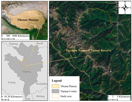
Figure 1.
Location of the Gexigou National Nature Reserve in eastern Tibet Plateau. The map is reproduced from Tianditu (https://www.tianditu.gov.cn/, accessed on 05 July 2024).
2.2. Data Sources
2.2.1. Landsat Satellite Imagery
Landsat images were courtesy of the U.S. Geological Survey (USGS, https://www.usgs.gov/, accessed on 07 October 2023) and were downloaded from the Google Earth Engine (GEE, https://developers.google.com/earth-engine/datasets/catalog/landsat, accessed on 07 October 2023). Landsat 5 imagery was used in 2000 and 2007, whereas Landsat 8 imagery was used in 2014 and 2021, totaling four images (see Table 1). With a spatial resolution of 30 m × 30 m and the geographic coordinate system of the World Geodetic System 1984 (WGS1984, EPSG: 4326), all photos were filtered manually to eliminate the impact of cloud cover and snow. All images primarily underwent geometric, atmospheric, and topographic correction.
2.2.2. Annual NDVI
As for the annual NDVI, we used the MODIS NDVI (MOD13Q1) dataset, provided by NASA’s Land Processes Distributed Active Archive Center (LP DAAC, https://lpdaac.usgs.gov/, accessed on 13 November 2023) and downloaded from the GEE (https://developers.google.com/earth-engine/datasets/catalog/MODIS_061_MOD13Q1, accessed on 13 November 2023). This dataset has a spatial resolution of 250 m × 250 m, with the geographic coordinate system of the WGS1984. We used the Maximum Value Composite (MVC) method to synthesize the annual NDVI data from 2000 to 2021. The MVC approach designates the highest value of each pixel throughout the course of the year as the annual NDVI value [26].

Table 1.
Data sources and descriptions.
Table 1.
Data sources and descriptions.
| Category | Data | Sources | Spatial Resolution |
|---|---|---|---|
| Satellite Imagery | LANDSAT/LT05/C02/T1_L2/LT05_131039_20001007 | Google Earth Engine https://developers.google.com/earth-engine/datasets/catalog/landsat accessed on 7 October 2023 | 30 m × 30 m |
| LANDSAT/LT05/C02/T1_L2/LT05_131039_20070301 | |||
| LANDSAT/LC08/C02/T1_L2/LC08_131039_20141201 | |||
| LANDSAT/LC08/C02/T1_L2/LC08_131039_20211001 | |||
| Annual NDVI | MOD13Q1 | Google Earth Engine https://developers.google.com/earth-engine/datasets/catalog/MODIS_061_MOD13Q1 accessed on 13 November 2023 | 250 m × 250 m |
| Elevation | ASTER GDEMV3 | Geospatial Data Cloud https://www.gscloud.cn/ accessed on 25 November 2023 | 30 m × 30 m |
| Climate | Maximum temperature | National Tibetan Plateau Data Center https://data.tpdc.ac.cn/ accessed on 25 November 2023 | 1000 m × 1000 m |
| Mean temperature | |||
| Minimum temperature | |||
| Precipitation |
2.2.3. Elevation
Elevation data were obtained from ASTER GDEMV3 at 30 m spatial resolution via the Geospatial Data Cloud (https://www.gscloud.cn/, accessed on 25 November 2023) with the geographic coordinate system of the WGS1984.
2.2.4. Climate
Climate data including precipitation, minimum temperature, mean temperature, and maximum temperature for the period 2000 to 2021 were obtained from the National Tibetan Plateau Data Center (NTPDC, https://data.tpdc.ac.cn/, accessed on 25 November 2023). Specifically, the maximum temperature data were obtained from the maximum temperature dataset [30], the mean temperature data were obtained from the mean temperature dataset [31], the minimum temperature data were obtained from the minimum temperature dataset [32], and the precipitation data were obtained from the precipitation dataset [33] for China over the period of 1901–2021 on a monthly basis and with the resolution of 1 km.
2.3. Data Processing and Analysis
2.3.1. Timberline Extraction
We have employed a technique that integrates GEE with GIS to extract data from the alpine timberline: (1) Initially, the NDVI was computed in GEE with Landsat images. Subsequently, the Otsu method, an automated image segmentation technique that does not rely on any prior information, was employed to extract segmented and non-forest pixels [34]; (2) The remaining processing was conducted in ArcGIS 10.7. The “RasterToPoint” tool was utilized to convert non-forest pixels into points. Specifically, points with an elevation exceeding 3500 m were extracted. This elevation threshold can effectively narrow down the extraction to the forest–valley boundary; (3) We utilized the “PointDensity” tool to assess the density of points and to identify point densities greater than 0.0005 for the purpose of removing smaller non-forested areas. It should be noted that 0.0005 is a flexible value, with smaller values resulting in the extraction of a greater number of small non-forested cells; (4) We used the “RasterToPolygon” tool to convert the selected point density raster to polygons and to eliminate polygons with an area of less than 90,000 m2 (100 pixels, a pixel of Landsat image measures 900 m2) to further eliminate small non-forested cells; (5) In order to smooth the polygons, we used the “PolygonToLine” tool to convert the polygons into lines. The final timberline extraction combined with the current year’s Landsat images, removed valleys, roads, and logged areas, which are easily affected by human activities or incorrectly extracted timberlines.
2.3.2. Timberline Vegetation Change
We used the annual NDVI (MOD13Q1) to quantify the vegetation changes in the timberline area. The NDVI change differences (NDVIdiff) and trends (NDVIslope) were calculated for the period 2000–2021. The NDVIdiff is calculated by subtracting the NDVI value of 2021 from the NDVI value of 2000 as
where NDVIdiff is the difference, NDVI2021 is the NDVI value of 2021, and NDVI2000 is the NDVI value of 2000.
The NDVIslope was calculated using a linear regression equation fitting method as [34,35]
where NDVIslope is the annual variation in NDVI, n is the number of years in the time series, and NDVIi is the NDVI value in the year i. A positive NDVI slope implies an inclination toward enhanced vegetation growth, while a negative slope indicates a declining trend in vegetation growth. For determining the significance of the NDVIslope tendency, a t-test was used. The results were classified into four categories: significant increase (NDVIslope > 0, p < 0.05), significant decrease (NDVIslope < 0, p < 0.05), insignificant increase (NDVIslope > 0, p > 0.05), and insignificant decrease (NDVIslope < 0, p > 0.05).
The overall flow of data processing is shown in Figure 2.
2.4. Data Analysis and Visualization
In order to examine the impact of climate change on timberline vegetation, we employed the Pearson correlation coefficient between the annual NDVI of the timberline and the maximum temperature, mean temperature, minimum temperature, and precipitation using the SPPSAU (https://spssau.com/en/, accessed on 17 December 2023). The results were visualized using the “Line_Regression” and “barplot” tools in Hiplot Pro (https://hiplot.com.cn/, accessed on 17 December 2023).
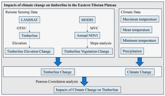
Figure 2.
Flowchart for the study of the impacts of climate change on timberline change on the eastern Tibetan Plateau (GNNR).
3. Results
3.1. Timberline Climate Change
In order to elucidate the climate change patterns in the study area during the past few decades, an analysis was conducted of the trends in precipitation, minimum temperature, mean temperature, and maximum temperature from 2000 to 2021 (Figure 3). Precipitation exhibited a statistically insignificant declining pattern (R2 = 0.14, p = 0.0898), with a rate of −3.39 mm/year (Figure 3a). The minimum temperature, on the other hand, displayed a statistically insignificant increasing trend (R2 = 0.03, p = 0.4758), with a rate of +0.02 °C·y−1 (Figure 3b). In contrast, the mean temperature exhibited a statistically significant increasing trend (R2 = 0.35, p = 0.0036), with a rate of +0.03 °C·y−1 (Figure 3c). Lastly, the maximum temperature showed a statistically insignificant increasing trend (R2 = 0.06, p = 0.2908), with a rate of +0.03 °C·y−1 (Figure 3d). Overall, the research area has experienced a simultaneous rise in temperature and a decline in precipitation since 2000. This large increase in average temperature could potentially affect the spatial distribution and growth of vegetation at the timberline.
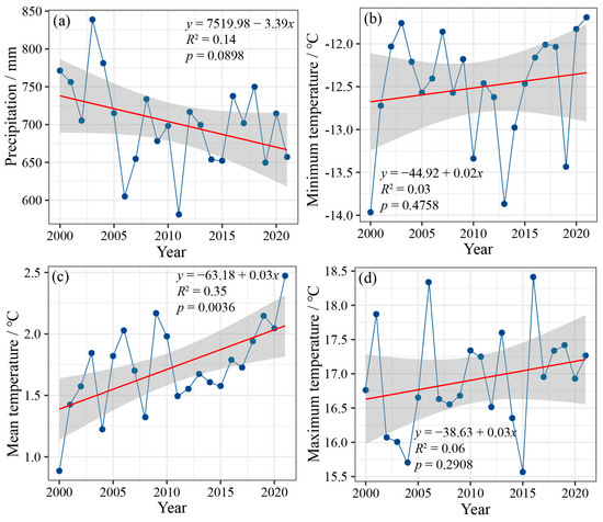
Figure 3.
Climate change trends at the timberline: (a) precipitation, (b) minimum temperature, (c) mean temperature, and (d) maximum temperature. The red line represents the linear trend of climate variables.
3.2. Timberline Elevation and Vegetation Changes
3.2.1. Timberline Extraction Results
Our methodology for the extraction of timberline based on Landsat imagery obtained an accurate timberline map (Figure 4). Based on the results, the timberline area was divided into 195 sample plots, each measuring 1000 m × 1000 m (Figure 4a). Compared with 2000, the timberline showed a clear upward shift in 2021 (Figure 4b,c).
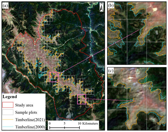
Figure 4.
Results of timberline extraction based on Landsat imagery. The background image is a Landsat-8 satellite image (LC08_131039_20211001), date: 01 October 2021.
3.2.2. Timberline Elevation Change
From 2000 to 2021 (22 years), the average timberline elevation in the study area continued to shift upward, with a cumulative upward shift of 48.83 m at a rate of +2.22 m/year (Table 2). The average elevation of the timberline was 4224.20 m in 2000, 4247.07 m in 2007, 4270.30 m in 2014, and 4273.03 m in 2021. While the elevation of the timberline continued to rise, the rate of ascent diminished significantly. The cumulative shifts of the average timberline elevation in the three periods of 2000–2007, 2007–2014, and 2014–2021 were +22.87 m, +23.23 m, and +2.73 m, with corresponding shift rates of +2.86 m/year, +2.90 m/year, and +0.34 m/year, respectively. Compared to the other two periods, from 2014–2021 the rate of the upward timberline shift was at a significantly slower rate.

Table 2.
Timberline elevation and changes.
The spatial distribution of the timberline exhibited a consistent pattern across the four periods, with the timberline elevation being higher in the central area and lower in the surrounding regions. This pattern aligns with the topographic features of the research area, as depicted in Figure 5. The elevation range of the timberline in the study area was 3985.68~4466.04 m (ranging 480.36 m) in 2000 (Figure 5a), 3960.07~4463.89 m (ranging 503.82 m) in 2007 (Figure 5b), 3951.57~4470.47 m (ranging 518.90 m) in 2014 (Figure 5c), and 3981.96~4467.67 m (ranging 485.71 m) in 2021 (Figure 5d). The minimum elevation of the timberline exhibits a decreasing trend followed by an increasing trend across the four periods, whereas the maximum timberline elevation remains relatively stable within a range of 4463.89 to 4470.47 m. Additionally, the range of timberline elevations shows an initial increase followed by a subsequent drop.
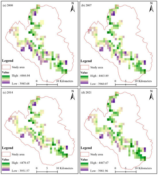
Figure 5.
Spatial variations in timberline altitude: (a) 2000, (b) 2007, (c) 2014, and (d) 2021.
We studied the changes in timberline elevation from 2000 to 2021, 2000 to 2007, 2007 to 2014, and 2014 to 2021 in order to better understand the spatial distribution of these changes (Figure 6). The shifts in timberline elevation were mainly upward in all periods. From 2000 to 2021, elevation shifts ranged from −65.51 m to 156.13 m, with 154 sample plots (78.97% of the total) showing an upward shift (Figure 6a). Between 2000 and 2007, the shifts ranged from −71.78 m to 138.00 m, with 129 sample plots (66.15% of the total) showing an upward shift (Figure 6b). During 2007 to 2014, the shifts ranged from −72.92 m to 153.89 m, with 129 sample plots (66.15% of the total) showing an upward movement (Figure 6c). Between 2014 and 2021, the shift was in the range of −50.73 m to 71.37 m, with 103 sample plots (52.82% of the total) with an upward trend (Figure 6d). Although the timberline has shown an overall upward shift over the past 22 years, the extent of the shifting area has reduced.
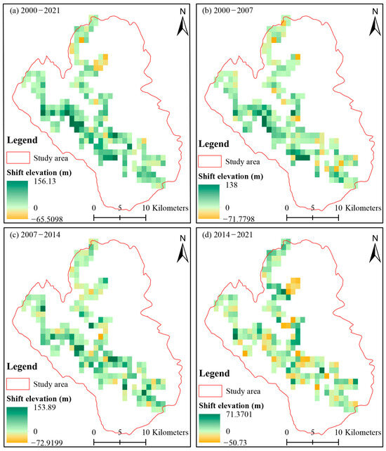
Figure 6.
Timberline altitude shift in (a) 2000–2021, (b) 2000–2007, (c) 2007–2014, and (d) 2014–2021.
3.2.3. Timberline NDVI Change
Overall, the timberline annual NDVI increased significantly from 2000 to 2021 (R2 = 0.2678, p = 0.0136) at a rate of +0.0015 per year. This indicates an improvement in the vegetation condition in this area (Figure 7). We also analyzed the spatial variation patterns in the annual NDVI (Figure 8) and found that during 2000–2021 most of the timberlines, covering 76.34% of the entire area, had positive NDVIdiff values (Figure 8a). Based on linear regression analysis, the timberline NDVI changes exhibited a statistically significant increase in 23.53% of the total area. Conversely, a statistically significant decrease was observed in only 0.63% of the total area, with a statistically insignificant decrease observed in 11.68% of the total area (Figure 8b). Both NDVIdiff and NDVIslope values indicated improvements in the vegetation conditions of the timberline area between 2000 and 2021.
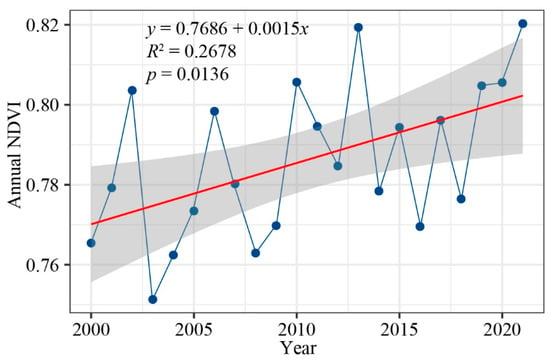
Figure 7.
Trends in annual NDVI changes in the timberline area. The red line represents the linear trend of the annual NDVI.
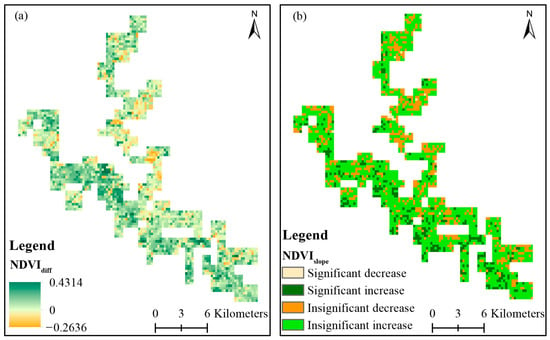
Figure 8.
Spatial variations in timberline NDVI: (a) NDVI changes (NDVIdiff) and (b) NDVI change trends (NDVIslope).
3.3. Impacts of Climate Change on Timberline Vegetation
To explore the impact of climate change on timberline vegetation growth, we used a Pearson correlation analysis between the annual NDVI and precipitation, minimum temperature, mean temperature, and maximum temperature in the timberline areas (Figure 9). At the annual scale, the annual NDVI in the timberline showed a negative correlation with annual precipitation (Figure 9a) and annual minimum temperature (Figure 9b) and a positive correlation with annual mean temperature (Figure 9c) and annual maximum temperature (Figure 9d). Among them, the annual NDVI in the timberline area had a substantial negative correlation with annual precipitation, with a correlation coefficient of ₋0.599 (p < 0.01) (Figure 9a), and it showed a significant positive correlation with annual mean temperature, with a correlation coefficient of 0.471 (p < 0.05) (Figure 9c). At the monthly scales, precipitation in most of the months was negatively correlated with the annual NDVI, while temperature was positively correlated with the annual NDVI. Among all monthly climate variables, the June maximum temperature, June mean temperature, and February maximum temperature were significantly positively correlated (p < 0.01) with the annual NDVI, with correlation coefficients of 0.681, 0.646, and 0.542, respectively. The February mean temperature and June minimum temperature were significantly positively correlated (p < 0.05) with the annual NDVI, with correlation coefficients of 0.502 and 0.437, respectively. This suggests that temperature promotes timberline vegetation growth, while precipitation acts as a suppressive factor.
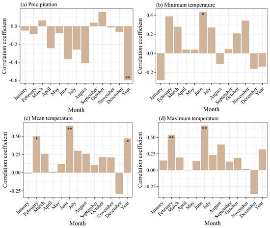
Figure 9.
Pearson correlation between timberline annual NDVI and climatic variables, (a) precipitation, (b) minimum temperature, (c) mean temperature, and (d) maximum temperature. * Indicates a significant correlation (p < 0.05), and ** indicates an extremely significant correlation (p < 0.01).
4. Discussion
In this research, we used remote sensing methods to investigate the response of the timberline to climate change in the GNNR. Our data indicate a substantial warming between 2000 and 2021, with an annual average temperature increase rate of +0.03 °C. Additional studies have demonstrated that the Tibetan Plateau is undergoing a significant rise in temperature, with the rate of warming surpassing that of other areas [36,37]. Increased temperatures will facilitate the expansion of vegetation at the timberline, resulting in a migration of the timberline to higher elevations [18,38]. Climate warming is considered to be the main cause of timberline changes at high altitudes and latitudes, and this view has been confirmed at Mount Fuji in Japan [39], the Yukon in Canada [19], southern Turkey, and the Venezuelan Andes [23], in addition to the Tibetan Plateau.
By analyzing the timberline extracted from satellite images, there is convincing evidence of a noticeable upward shift of the timberline. The elevation of the timberline in the studied area increased by 48 m between 2000 and 2021, with an average annual rate of +2.22 m/year. According to [18], it has been verified that the timberline on the Tibetan Plateau moves higher as a result of climatic warming. Nevertheless, as a result of biotic inertia, the pace at which the timberline moves is consistently slower than the pace of climatic change, typically about half or even less than the rate of climate change [13]. Moreover, the rates at which timberlines are shifting are not consistent. Specifically, the timberline shift rate between 2014 and 2021 was much lower at +0.34 m/year compared to the shift rates between 2000 and 2007 (+2.86 m/year) and between 2007 and 2014 (+2.90 m/year). This suggests that there are additional factors, like as precipitation and soil moisture, that can impede or even prevent the shift in the timberline caused by climate warming [40,41]. Additionally, we observed a correlation between the rise in temperature within the research area and a decline in precipitation. While warming may alleviate the temperature limitations on alpine plants, the growth of alpine flora is constrained by a lack of moisture as the climate continues to warm [42]. According to Wang et al. (2021), the growth of alpine vegetation has been hindered in recent years due to a lack of rainfall [1].
Between 2000 and 2021, there was no significant change in the maximum timberline elevation. However, the lowest timberline elevation initially decreased and then subsequently increased. This is an outcome of the forest being disrupted by human activity. Despite our efforts to manually remove the timberline extraction results that could be affected by human actions, total avoidance has not yet been achieved. The GNNR did not receive official recognition as a national nature reserve until 2012. Prior to this period, there were regular human activities taking place in the GNNR, including grazing and logging, predominantly concentrated at lower altitudes. Consequently, the lowest elevation at which trees may grow varies unpredictably, whereas the maximum elevation at which trees can grow is rather constant. The analysis of the geographical pattern of timberline change revealed that a greater proportion of the sampled plots saw a reduction in elevation from 2014 to 2021 compared to previous time periods. When human activities are not taken into account, the growth of vegetation is negatively affected by drought stress in a warmer environment with less precipitation. This can lead to a drop in the alpine timberline in certain places [1,43].
In addition to the elevation of the timberline, the growth patterns of vegetation at the timberline are also strongly influenced by climate change [18,44]. Similar to previous research conducted on the Tibetan Plateau, there has been a noteworthy rise in the timberline NDVI and a substantial enhancement in plant growth since 2000 [38,45]. During our investigation of the impact of climate change on timberline vegetation, we discovered a strong negative correlation (p < 0.01) between the timberline NDVI and annual precipitation, as well as a substantial positive correlation (p < 0.05) between the timberline NDVI and mean annual temperature. Ge et al. (2021) found that increased temperatures and decreased precipitation are the factors that positively influence vegetation growth [46]. Warming has a significant impact on alpine vegetation, since it lengthens the growing season and promotes the growth of timberline vegetation [5,18]. Previous research has also observed the suppressive impact of precipitation on vegetation development in the eastern Tibetan Plateau [37,46,47]. This is likely due to the higher moisture levels in the eastern Tibetan Plateau, which allows plants to thrive without being limited by water stress. Conversely, increased precipitation results in a decline in sun radiation, which hampers the process of photosynthesis in plants and thus hinders vegetation development [47,48,49]. It is crucial to observe that this conclusion does not contradict the previously stated perspective that increased drought stress can result in a reduction in timberline. The timberline alterations are influenced by factors such as increased vegetation growth, as well as the successful germination of seeds, survival of seedlings, and establishment of young trees at the timberline [7,18].
Furthermore, our examination of the correlation between monthly climatic factors and the growth of timberline vegetation revealed that temperature on a monthly scale exerted the greatest influence on the growth of timberline vegetation, particularly during the months of February and June. Vegetation growth in the eastern Tibetan Plateau is mostly constrained by the temperatures experienced throughout the spring and summer [1]. Increased temperatures in spring expedite the thawing of plateau permafrost and create an optimal soil moisture condition for the establishment of vegetation [50,51]. The temperature throughout the growing season (May–October) is a significant factor affecting the vegetation at the timberline. Warmer temperatures have a positive impact on seed viability, seedlings’ emergence, and their subsequent growth [7,8,52]. Consequently, there is a strong and positive association between temperatures in February and June and the timberline NDVI.
5. Conclusions
The results of this study demonstrate the practicality of using remote sensing methods in the study of timberline changes, where warming has resulted in an upward shift of the alpine timberline; however, the rate of this upward shift is decelerating. While warmer temperatures might enable timberline vegetation to surpass cold temperatures constraints, a persistent decrease in precipitation could result in heightened drought stress on timberline vegetation, potentially leading to a danger of timberline decline. In addition to changes in timberline elevation, there has been a substantial enhancement in the growth of timberline vegetation at the GNNR over the last 22 years, which is strongly correlated with climate change. The elevated temperatures throughout the spring and growing seasons have a positive impact on the development of flora at high altitudes. Increasing temperatures facilitate the expansion of timberline vegetation; however, precipitation has a detrimental impact on its growth. Timberline elevation and timberline vegetation growth responded differently to precipitation, as changes in timberline elevation were not only associated with increased vegetation growth but also with seed germination, seedling survival, and young tree establishment on the timberline. In future studies, it is imperative to prioritize the investigation of climate change’s impact on seed germination, seedling recruitment, and tree island development. Additionally, a comprehensive exploration of the timberline’s reaction to climate change should be conducted.
Author Contributions
Conceptualization, X.P. and P.P.; data curation, Y.F. and S.Z.; formal analysis, H.Z.; funding acquisition, J.W. and P.P.; investigation, X.P.; methodology, X.P. and Z.C.; project administration, P.P.; resources, Y.F.; software, Y.F.; supervision, Y.F. and D.Z.; validation, X.P., H.Z. and D.Z.; visualization, X.P., Y.F. and D.Z.; writing—original draft, X.P.; writing—review and editing, D.Z. and J.W. All authors have read and agreed to the published version of the manuscript.
Funding
This research was funded by the Second Tibetan Plateau Scientific Expedition and Research Program (STEP), China (No. 2019QZKK0301); Sichuan Province Natural Science Foundation Project (No. 2024NSFSC0355).
Institutional Review Board Statement
Not applicable.
Informed Consent Statement
Not applicable.
Data Availability Statement
The data presented in this study are available on request from the corresponding author. The data are not publicly available due to the ongoing project to which the data belong.
Acknowledgments
We would like to acknowledge the assistance of the Shanghai Tengyun Biotechnology Co., Ltd. in developing the Hiplot Pro platform (https://hiplot.com.cn/) and providing technical guidance and valuable tools for data analysis and visualization.
Conflicts of Interest
The authors declare no conflicts of interest.
References
- Wang, Y.; Liang, E.; Lu, X.; Camarero, J.J.; Babst, F.; Shen, M.; Peñuelas, J. Warming-induced shrubline advance stalled by moisture limitation on the Tibetan Plateau. Ecography 2021, 44, 1631–1641. [Google Scholar] [CrossRef]
- Guo, M.; Zhang, Y.; Wang, X.; Gu, F.; Liu, S. The responses of dominant tree species to climate warming at the treeline on the eastern edge of the Tibetan Plateau. For. Ecol. Manag. 2018, 425, 21–26. [Google Scholar] [CrossRef]
- Zhou, T.; Zhang, W. Anthropogenic warming of Tibetan Plateau and constrained future projection. Environ. Res. Lett. 2021, 16, 044039. [Google Scholar] [CrossRef]
- Kummel, M.; McGarigal, A.; Kummel, M.; Earnest, C.; Feiden, M. Tree establishment and growth drive treeline advance and change treeline form on Pikes Peak (Colorado) in response to recent anthropogenic warming. Can. J. For. Res. 2021, 51, 1458–1471. [Google Scholar] [CrossRef]
- Hansson, A.; Dargusch, P.; Shulmeister, J. A review of modern treeline migration, the factors controlling it and the implications for carbon storage. J. Mt. Sci. 2021, 18, 291–306. [Google Scholar] [CrossRef]
- Camarero, J.J.; Gazol, A.; Sanchez-Salguero, R.; Fajardo, A.; McIntire, E.J.B.; Gutierrez, E.; Batllori, E.; Boudreau, S.; Carrer, M.; Diez, J.; et al. Global fading of the temperature-growth coupling at alpine and polar treelines. Glob. Chang. Biol. 2021, 27, 1879–1889. [Google Scholar] [CrossRef]
- Lu, X.; Liang, E.; Wang, Y.; Babst, F.; Camarero, J.J.; Grytnes, J.A. Mountain treelines climb slowly despite rapid climate warming. Glob. Ecol. Biogeogr. 2020, 30, 305–315. [Google Scholar] [CrossRef]
- Lyu, L.; Zhang, Q.-B.; Pellatt, M.G.; Büntgen, U.; Li, M.-H.; Cherubini, P. Drought limitation on tree growth at the Northern Hemisphere’s highest tree line. Dendrochronologia 2019, 53, 40–47. [Google Scholar] [CrossRef]
- Singh, S.P.; Sharma, S.; Dhyani, P.P. Himalayan arc and treeline: Distribution, climate change responses and ecosystem properties. Biodivers. Conserv. 2019, 28, 1997–2016. [Google Scholar] [CrossRef]
- Liang, E.; Wang, Y.; Piao, S.; Lu, X.; Camarero, J.J.; Zhu, H.; Zhu, L.; Ellison, A.M.; Ciais, P.; Penuelas, J. Species interactions slow warming-induced upward shifts of treelines on the Tibetan Plateau. Proc. Natl. Acad. Sci. USA 2016, 113, 4380–4385. [Google Scholar] [CrossRef]
- Korner, C. ‘Fading of the temperature-growth coupling’ in treeline trees reflects a conceptual bias. Glob. Chang. Biol. 2021, 27, 3951–3952. [Google Scholar] [CrossRef] [PubMed]
- Franke, A.K.; Feilhauer, H.; Bräuning, A.; Rautio, P.; Braun, M. Remotely sensed estimation of vegetation shifts in the polar and alpine tree-line ecotone in Finnish Lapland during the last three decades. For. Ecol. Manag. 2019, 454, 117668. [Google Scholar] [CrossRef]
- Dial, R.J.; Smeltz, T.S.; Sullivan, P.F.; Rinas, C.L.; Timm, K.; Geck, J.E.; Tobin, S.C.; Golden, T.S.; Berg, E.C. Shrubline but not treeline advance matches climate velocity in montane ecosystems of south-central Alaska. Glob. Chang. Biol. 2016, 22, 1841–1856. [Google Scholar] [CrossRef]
- Guo, D.; Yu, E.; Wang, H. Will the Tibetan Plateau warming depend on elevation in the future? J. Geophys. Res. Atmos. 2016, 121, 3969–3978. [Google Scholar] [CrossRef]
- Liu, B.; Li, Y.; Eckstein, D.; Zhu, L.; Dawadi, B.; Liang, E. Has an extending growing season any effect on the radial growth of Smith fir at the timberline on the southeastern Tibetan Plateau? Trees 2012, 27, 441–446. [Google Scholar] [CrossRef]
- Yang, L.; Cui, G.; Zhao, W.; Zhang, Z.; Luo, T.; Zhang, L. Sensitivity of radial growth of subalpine conifer trees to climate warming on the southeastern Tibetan Plateau. Glob. Ecol. Conserv. 2023, 43, e02470. [Google Scholar] [CrossRef]
- Qin, L.; Liu, K.; Shang, H.; Zhang, T.; Yu, S.; Zhang, R. Minimum temperature during the growing season limits the radial growth of timberline Schrenk spruce (P. schrenkiana). Agric. For. Meteorol. 2022, 322, 109004. [Google Scholar] [CrossRef]
- Zheng, L.; Shi, P.; Zhou, T.; Hou, G.; Song, M.; Yu, F. Tree Regeneration Patterns on Contrasting Slopes at Treeline Ecotones in Eastern Tibet. Forests 2021, 12, 1605. [Google Scholar] [CrossRef]
- Myers-Smith, I.H.; Hik, D.S. Climate warming as a driver of tundra shrubline advance. J. Ecol. 2018, 106, 547–560. [Google Scholar] [CrossRef]
- He, W.; Ye, C.; Sun, J.; Xiong, J.; Wang, J.; Zhou, T. Dynamics and Drivers of the Alpine Timberline on Gongga Mountain of Tibetan Plateau-Adopted from the Otsu Method on Google Earth Engine. Remote Sens. 2020, 12, 2651. [Google Scholar] [CrossRef]
- Xu, D.; Geng, Q.; Jin, C.; Xu, Z.; Xu, X. Tree Line Identification and Dynamics under Climate Change in Wuyishan National Park Based on Landsat Images. Remote Sens. 2020, 12, 2890. [Google Scholar] [CrossRef]
- Ye, P.; Yu, B.; Chen, W.; Liu, K.; Ye, L. Rainfall-induced landslide susceptibility mapping using machine learning algorithms and comparison of their performance in Hilly area of Fujian Province, China. Nat. Hazards 2022, 113, 965–995. [Google Scholar] [CrossRef]
- Arekhi, M.; Yesil, A.; Ozkan, U.Y.; Balik Sanli, F. Detecting treeline dynamics in response to climate warming using forest stand maps and Landsat data in a temperate forest. For. Ecosyst. 2018, 5, 23. [Google Scholar] [CrossRef]
- Ma, X.; Bai, H.; Deng, C.; Wu, T. Sensitivity of Vegetation on Alpine and Subalpine Timberline in Qinling Mountains to Temperature Change. Forests 2019, 10, 1105. [Google Scholar] [CrossRef]
- Wang, Y.; Shen, X.; Tong, S.; Zhang, M.; Jiang, M.; Lu, X. Aboveground Biomass of Wetland Vegetation Under Climate Change in the Western Songnen Plain. Front. Plant Sci. 2022, 13, 941689. [Google Scholar] [CrossRef] [PubMed]
- Meng, X.; Gao, X.; Li, S.; Lei, J. Spatial and Temporal Characteristics of Vegetation NDVI Changes and the Driving Forces in Mongolia during 1982–2015. Remote Sens. 2020, 12, 603. [Google Scholar] [CrossRef]
- Ruan, Z.; Kuang, Y.; He, Y.; Zhen, W.; Ding, S. Detecting Vegetation Change in the Pearl River Delta Region Based on Time Series Segmentation and Residual Trend Analysis (TSS-RESTREND) and MODIS NDVI. Remote Sens. 2020, 12, 4049. [Google Scholar] [CrossRef]
- Kern, A.; Marjanović, H.; Barcza, Z. Spring vegetation green-up dynamics in Central Europe based on 20-year long MODIS NDVI data. Agric. For. Meteorol. 2020, 287, 107969. [Google Scholar] [CrossRef]
- Feng, Y.; Shi, S.; Peng, P.; Zhou, Q.; Wang, H.; Liu, X. Lengthening of the growth season, not increased water availability, increased growth of Picea likiangensis var. rubescens plantations on eastern Tibetan Plateau due to climate change. Web Ecol. 2022, 22, 47–58. [Google Scholar] [CrossRef]
- Peng, S. 1-km Monthly Maximum Temperature Dataset for China (1901–2021). National Tibetan Plateau Data Center [Dataset]. 2020. Available online: https://zenodo.org/records/3114194 (accessed on 25 November 2023).
- Peng, S. 1-km Monthly Mean Temperature Dataset for China (1901–2021). National Tibetan Plateau Data Center [Dataset]. 2020. Available online: https://data.tpdc.ac.cn/en/data/71ab4677-b66c-4fd1-a004-b2a541c4d5bf/ (accessed on 25 November 2023).
- Peng, S. 1-km Monthly Minimum Temperature Dataset for China (1901–2021). National Tibetan Plateau Data Center [Dataset]. 2020. Available online: https://zenodo.org/records/3114194 (accessed on 25 November 2023).
- Peng, S. 1-km Monthly Precipitation Dataset for China (1901–2021). National Tibetan Plateau Data Center [Dataset]. 2020. Available online: https://zenodo.org/records/3185722 (accessed on 25 November 2023).
- He, J.; Shi, X.; Fu, Y. Identifying vegetation restoration effectiveness and driving factors on different micro-topographic types of hilly Loess Plateau: From the perspective of ecological resilience. J. Environ. Manag. 2021, 289, 112562. [Google Scholar] [CrossRef]
- Feng, Y.; Wang, J.; Zhou, Q.; Bai, M.; Peng, P.; Zhao, D.; Guan, Z.; Liu, X. Quantitative analysis of vegetation restoration and potential driving factors in a typical subalpine region of the Eastern Tibet Plateau. PeerJ 2022, 10, e13358. [Google Scholar] [CrossRef] [PubMed]
- Dai, L.; Ke, X.; Guo, X.; Du, Y.; Zhang, F.; Li, Y.; Li, Q.; Lin, L.; Peng, C.; Shu, K.; et al. Responses of biomass allocation across two vegetation types to climate fluctuations in the northern Qinghai-Tibet Plateau. Ecol. Evol. 2019, 9, 6105–6115. [Google Scholar] [CrossRef]
- Gao, Y.; Zhou, X.; Wang, Q.; Wang, C.; Zhan, Z.; Chen, L.; Yan, J.; Qu, R. Vegetation net primary productivity and its response to climate change during 2001-2008 in the Tibetan Plateau. Sci. Total Environ. 2013, 444, 356–362. [Google Scholar] [CrossRef]
- Zhang, Z.; Chang, J.; Xu, C.Y.; Zhou, Y.; Wu, Y.; Chen, X.; Jiang, S.; Duan, Z. The response of lake area and vegetation cover variations to climate change over the Qinghai-Tibetan Plateau during the past 30 years. Sci. Total Environ. 2018, 635, 443–451. [Google Scholar] [CrossRef] [PubMed]
- Sakio, H.; Masuzawa, T. Advancing Timberline on Mt. Fuji between 1978 and 2018. Plants 2020, 9, e1537. [Google Scholar] [CrossRef] [PubMed]
- Maher, C.T.; Dial, R.J.; Pastick, N.J.; Hewitt, R.E.; Jorgenson, M.T.; Sullivan, P.F. The climate envelope of Alaska’s northern treelines: Implications for controlling factors and future treeline advance. Ecography 2021, 44, 1710–1722. [Google Scholar] [CrossRef]
- Srur, A.M.; Villalba, R.; Rodríguez-Catón, M.; Amoroso, M.M.; Marcotti, E. Climate and Nothofagus pumilio Establishment at Upper Treelines in the Patagonian Andes. Front. Earth Sci. 2018, 6, 57. [Google Scholar] [CrossRef]
- Dolezal, J.; Kurnotova, M.; Stastna, P.; Klimesova, J. Alpine plant growth and reproduction dynamics in a warmer world. New Phytol. 2020, 228, 1295–1305. [Google Scholar] [CrossRef] [PubMed]
- Urza, A.K.; Weisberg, P.J.; Dilts, T. Evidence of widespread topoclimatic limitation for lower treelines of the Intermountain West, United States. Ecol. Appl. 2020, 30, e02158. [Google Scholar] [CrossRef]
- Conlisk, E.; Castanha, C.; Germino, M.J.; Veblen, T.T.; Smith, J.M.; Kueppers, L.M.; Matlack, G. Declines in low-elevation subalpine tree populations outpace growth in high-elevation populations with warming. J. Ecol. 2017, 105, 1347–1357. [Google Scholar] [CrossRef]
- Shen, X.; Liu, B.; Jiang, M.; Wang, Y.; Wang, L.; Zhang, J.; Lu, X. Spatiotemporal Change of Marsh Vegetation and Its Response to Climate Change in China From 2000 to 2019. J. Geophys. Res. Biogeosci. 2021, 126, e2020JG006154. [Google Scholar] [CrossRef]
- Ge, W.; Deng, L.; Wang, F.; Han, J. Quantifying the contributions of human activities and climate change to vegetation net primary productivity dynamics in China from 2001 to 2016. Sci. Total Environ. 2021, 773, 145648. [Google Scholar] [CrossRef] [PubMed]
- Luo, Z.; Wu, W.; Yu, X.; Song, Q.; Yang, J.; Wu, J.; Zhang, H. Variation of Net Primary Production and Its Correlation with Climate Change and Anthropogenic Activities over the Tibetan Plateau. Remote Sens. 2018, 10, 1352. [Google Scholar] [CrossRef]
- Li, X.; Xiao, J.; He, B. Higher absorbed solar radiation partly offset the negative effects of water stress on the photosynthesis of Amazon forests during the 2015 drought. Environ. Res. Lett. 2018, 13, 044005. [Google Scholar] [CrossRef]
- Zhao, A.; Wang, D.; Xiang, K.; Zhang, A. Vegetation photosynthesis changes and response to water constraints in the Yangtze River and Yellow River Basin, China. Ecol. Indic. 2022, 143, 109331. [Google Scholar] [CrossRef]
- Sankey, T.; Belmonte, A.; Massey, R.; Leonard, J.; Disney, M.; Armenteras, D. Regional-scale forest restoration effects on ecosystem resiliency to drought: A synthesis of vegetation and moisture trends on Google Earth Engine. Remote Sens. Ecol. Conserv. 2020, 7, 259–274. [Google Scholar] [CrossRef]
- Keyimu, M.; Li, Z.; Liu, G.; Fu, B.; Fan, Z.; Wang, X.; Wu, X.; Zhang, Y.; Halik, U. Tree-ring based minimum temperature reconstruction on the southeastern Tibetan Plateau. Quat. Sci. Rev. 2021, 251, 106712. [Google Scholar] [CrossRef]
- Zindros, A.; Radoglou, K.; Milios, E.; Kitikidou, K. Tree Line Shift in the Olympus Mountain (Greece) and Climate Change. Forests 2020, 11, 985. [Google Scholar] [CrossRef]
Disclaimer/Publisher’s Note: The statements, opinions and data contained in all publications are solely those of the individual author(s) and contributor(s) and not of MDPI and/or the editor(s). MDPI and/or the editor(s) disclaim responsibility for any injury to people or property resulting from any ideas, methods, instructions or products referred to in the content. |
© 2024 by the authors. Licensee MDPI, Basel, Switzerland. This article is an open access article distributed under the terms and conditions of the Creative Commons Attribution (CC BY) license (https://creativecommons.org/licenses/by/4.0/).