Article

First Detections of Ionospheric Plasma Density Irregularities from GOES Geostationary GPS Observations during Geomagnetic Storms

1
COSMIC Program Office, University Corporation for Atmospheric Research, Boulder, CO 80301, USA
2
Space Radio-Diagnostic Research Center, University of Warmia and Mazury, 10-719 Olsztyn, Poland
*
Author to whom correspondence should be addressed.
Atmosphere 2024, 15(9), 1065; https://doi.org/10.3390/atmos15091065
Submission received: 5 July 2024 / Revised: 12 August 2024 / Accepted: 30 August 2024 / Published: 3 September 2024
(This article belongs to the Special Issue Ionospheric Irregularity)

Abstract

:
In this study, we present the first results of detecting ionospheric irregularities using non-typical GPS observations recorded onboard the Geostationary Operational Environmental Satellites (GOES) mission operating at ~35,800 km altitude. Sitting above the GPS constellation, GOES can track GPS signals only from GPS transmitters on the opposite side of the Earth in a rather unique geometry. Although GPS receivers onboard GOES are primarily designed for navigation and were not configured for ionospheric soundings, these GPS measurements along links that traverse the Earth’s ionosphere can be used to retrieve information about ionospheric electron density. Using the radio occultation (RO) technique applied to GPS measurements from the GOES–16, we analyzed variations in the ionospheric total electron content (TEC) on the links between the GPS transmitter and geostationary GOES GPS receiver. For case-studies of major geomagnetic storms that occurred in September 2017 and August 2018, we detected and analyzed the signatures of storm-induced ionospheric irregularities in novel and promising geostationary GOES GPS observations. We demonstrated that the presence of ionospheric irregularities near the GOES GPS RO sounding field of view during geomagnetic disturbances was confirmed by ground-based GNSS observations. The use of RO observations from geostationary orbit provides new opportunities for monitoring ionospheric irregularities and ionospheric density.

1. Introduction

Today’s society relies more and more on Global Navigation Satellite Systems (GNSSs) and satellite-to-Earth communications in a wide range of industries and critical systems. The important threats for the GNSS and satellite communications are the ionospheric plasma gradients and corresponding signal scintillations. Such ionosphere-related signal scintillations are rapid fluctuations in the amplitude, phase, and angle of propagated radio signals due to the presence of ionospheric irregularities and plasma density gradients that the radio signals traverse. Scintillations occur at a broad range of frequencies. L-Band scintillation adversely impacts on the trans-ionospheric communications, as well as on the continuous tracking of GNSS signals for position, navigation, and timing services [1,2,3,4,5,6]. The most severe ionospheric plasma irregularities and scintillations occur primarily in the low-latitude region [7,8,9,10], and, here, they are associated with the development of equatorial plasma bubbles [10,11,12,13]. The plasma irregularities at mid- and high latitudes are mainly related to space weather, specifically how the ionosphere responds to the geomagnetic disturbances [14,15]. During geomagnetic storms, the energy input coming from the magnetosphere–ionosphere interaction in the form of enhanced electric fields, currents, and energetic particle precipitation perturbs the ionosphere through high-latitude ionization, Joule and particle heating, ion-drag forcing, and disturbed electric fields, resulting in ionospheric irregularities and strong plasma density gradients and enhancements [16,17,18]. The fact is that ionospheric irregularities possess a wide range of spatial and temporal scales and occur at different geographical locations [18].
Ionospheric irregularities are detected and studied mainly by two techniques: direct in situ measurements of plasma density by satellites and remote sensing based on radio wave propagation. The in situ plasma density observations onboard different satellite missions (e.g., Huang et al. [19] and Burke et al. [20] with DMSP operated at ~840 km altitude, Huang et al. [21] and Yizengaw and Groves [22] with C/NOFS at 400–850 km orbit altitude, Su et al. [23] with ROCSAT-1 at 300–400 km orbit altitude, Xiong et al. [24] with CHAMP at 300–400 km orbit altitude, and Zakharenkova et al. [25] with Swarm constellation at ~500 km orbit altitude) were used to detect plasma density variations along the satellite orbits. From these measurements, statistical parameters for equatorial plasma bubble occurrence, responsible for plasma density gradients, were derived. Recently, Zakharenkova et al. [26] presented an approach for identifying the ionospheric plasma density irregularities form the Ion Velocity Meter (IVM) in situ plasma density observations onboard the new COSMIC-2 mission. Here, the detected irregularities related with the equatorial plasma bubble development were geolocated on the satellite orbit planes, with further construction of the global maps of the plasma bubble locations based on the initial detection of IVM irregularities. The major limitation of the satellite in situ measurements is that these data represent a one-dimensional horizontal cut of the ionosphere at a fixed altitude. So, the detection of ionospheric irregularities strongly depends on whether these structures have already reached the satellite orbit altitude or not.
The ground-based GNSS observations are successfully used to characterize the occurrence of ionospheric plasma irregularities and their intensity by the ROT (rate of change of total electron content (TEC)) and ROTI (ROT index) [27,28]. Based on the results reported in [28,29,30], it was concluded that the ROTI could be also effectively used as a proxy for assessing the presence of amplitude scintillations. For several decades, the GNSS ROTI has effectively been used for the monitoring and research of ionospheric irregularity occurrence at high [31,32,33,34,35,36,37] and equatorial [38,39,40,41,42] latitudes. The application of the ROTI approach with different mapping techniques allows us to trace plasma irregularity dynamics at different temporal resolutions, on both global and regional scales [43,44,45]. It is important to acknowledge that ground-based GNSS measurements have a notable limitation—the challenge in identifying the altitude range where exactly ionospheric irregularities occur.
GNSS Radio Occultation (RO) is a satellite remote sensing technique that uses GNSS signal measurements received by low-Earth-orbiting (LEO) satellites to profile the Earth’s ionosphere with a high vertical resolution and global coverage. LEO RO satellites typically operate at orbit altitudes between 300 and 700 km, thus providing a unique opportunity to estimate the vertical distribution of ionospheric plasma below LEO altitude at various locations around the globe. By placing a GPS receiver onboard a LEO satellite in 1995, the GPS/MET Experiment was a pioneer in demonstrating the applicability of the GPS-based RO technique to retrieve a vertical distribution of electron density in the Earth’s ionosphere [46,47]. Since that time, many satellite missions were launched into LEO orbits featuring GPS/GNSS RO receivers onboard—Oerstedt, SAC-C, CHAMP, GRACE, COSMIC, COSMIC-2, Spire, CASSIOPE, MetOp, TerraSAR, etc. [48,49,50,51,52]. Nowadays, the ionospheric profiles derived from LEO-based RO observations have become a critical data source for real-time monitoring and research of the Earth’s ionosphere [53,54,55]. For ionospheric irregularity investigation, analysis of the LEO-based RO profiles allows for identifying altitude distributions of the steep ionospheric plasma gradients and to detect the presence of the plasma irregularities in the vertical domain. This technique was used for the climatological study of low-latitude ionospheric irregularities [56,57,58], as well as for case-studies of ionospheric responses to the geomagnetic storms [59,60].
Recently, Gleason at al. [61] and Zakharenkova et al. [62] presented interesting results of the ionosphere and plasmasphere RO soundings using the geometry of the links between geostationary Earth orbit (GEO) and GPS satellites when a GPS receiver is placed onboard a GEO satellite. In those papers, we discussed a novel retrieval of the ionospheric EDPs not from LEO but from the GEO, specifically from the Geostationary Operational Environmental Satellites (GOES) mission, which operate at ~35,800 km altitude. They have demonstrated the applicability of GEO RO for retrieving the vertical distribution of the electron density in the Earth’s ionosphere and evaluated the performance of the retrieved electron density profiles by direct comparisons with ground-based ionosondes and LEO RO products as the references. It was found that the GEO–GPS RO sounding geometry is quite repeatable from day to day due to the slow precession of the GPS satellites’ orbit. This allows for assessing the ionospheric conditions over a specific location for many days in a row, which is rather similar to ground-based instruments, like ionosondes or incoherent scatter radars.
Inspired by these results obtained for geomagnetically quiet conditions, our new investigation focused on GEO–GPS RO sounding results during geomagnetic storms. The aim was to examine the possibilities of identifying the signatures of ionospheric disturbances and ionospheric plasma density gradients and irregularities with this new type of observation.

2. Materials and Methods

The results obtained in this study are based on the GPS observations from two GOES satellites, GOES-R (known also as GOES-16) and GOES-S (known also as GOES-17). The GOES mission operates at ~35,800 km altitude and its observations serve for real-time weather forecasting. The GPS receivers onboard these GOES satellites were designed for navigation purposes but can track GPS signals propagated through the atmosphere and ionosphere of the Earth. Within the framework of the NASA Exploring GNSS Remote Sensing at GEO Using GOES GPS Receivers project, we obtained navigation and tracking datasets from the GOES-16 and GOES-17 GPS receivers.
The GPS signals, tracked by the receiver, are coming from the GPS transmitter located on the opposite side of the Earth. Figure 1 shows the sketch view on how the GPS receivers onboard the GOES mission observe GPS satellites during a GEO-based RO experiment, which is quite different from the traditional LEO-based RO. For a LEO RO experiment, a LEO satellite is typically orbiting within the ionosphere (300–800 km in altitude) and GPS satellites are at ~20,200 km orbit altitude. GPS and LEO satellites form a configuration such that the GPS satellite is considered almost stationary during an occultation session and the LEO satellite is moving quickly, thus forming multiple slices of the Earth’s ionosphere with those GPS–LEO links. In the case of the GEO-based RO experiment, the GEO satellite is stationary and the GPS satellite is moving much faster, creating the occultation links. It is important to note that the signal transmissions from the GPS satellites are intentionally directed toward the Earth’s surface for the advantage of terrestrial users (not away from the Earth or toward the geostationary orbit slots). Therefore, the only signals available to the receivers mounted on the GOES satellites are those transmitted by GPS satellites from the relative opposite side of the Earth or acquired from the side or back lobes of the GPS antennas. Thus, in the GOES–GPS RO experiment, the distance between satellites along the ray path is significantly larger than in any LEO RO. When these GPS signals propagate along this ~60,000 km distance link, they pass through the Earth’s ionosphere where they experience phase delays. These signal phase delays can be processed into estimates of the total electron content along the observation path and also can retrieve electron density profiles by the approach developed by Ao et al. [63]. The general algorithm for the retrieval of electron density profiles using measurements from the GOES GPS receivers was described in [62]. The dataset we analyzed consists of ionospheric observations from July 2017 to May 2022 for GOES–16 and from November 2018 to May 2022 for GOES–17. Because the GPS receivers onboard GOES satellites were not designed and configured for RO, the number of successful RO retrievals is quite limited. Finally, we have retrieved about 13,000 GEO RO ionospheric soundings covering an altitudinal range of 80–2000 km [62].
The time period from July 2017 to May 2022 marked a transition between the 24th to 25th solar cycle, characterized by a low-to-moderate solar activity level. Two major geomagnetic storms took place during the specified period, one on 7–8 September 2017 (with a minimum SYM-H of around –145 nT) and another on 26 August 2018 (with a minimum SYM-H of –206 nT). The severe ionospheric responses, including the development of strong ionospheric plasma density gradients and ionospheric irregularities, were reported for both cases of these geomagnetic storms [64,65,66].
Our analysis focused on the GOES GEO RO ionospheric soundings dataset to identify the ionospheric plasma irregularities resulting from the geomagnetic storms on 7–8 September 2017 and 25–26 August 2018. For these two major geomagnetic storms, only data from GOES–16 were available as GOES–17 was not in operational mode yet; so, this study will utilize GOES–16 data only. To retrieve the signatures of the ionospheric irregularities, we analyzed the rate of change of the total electron content along the GOES GPS–GPS transmitter links, using a method similar to one applied for ionospheric irregularity detection with the ground-based GNSS observations (more details in [28]). To confirm the presence of ionospheric plasma gradients and irregularities within an area of GOES GEO RO ionospheric soundings, we examined observations from the Global Navigation Satellite System (GNSS) networks, which allowed us to detect such ionospheric density gradients and irregularities at high, middle, and low latitudes. For the overall representation of the spatial evolution of plasma irregularities, we analyzed the daily ROTI polar maps. Such maps are based on multi-station GNSS observations and include the following: the calculation of the rate of TEC (ROT) values for every selected ground station-to-GNSS transmitter link, calculation of the ROT index (ROTI) [28], and mapping of all the ROTI values in the magnetic latitudes–magnetic local time coordinate system. The ROTI mapping technique was described in detail in Cherniak et al. [43,44]. Such ROTI maps can be used to monitor ionospheric irregularities with a daily overview, which clearly show the evolution of the irregularity oval as a geomagnetic storm develops. For detailed investigations of ionospheric irregularity dynamics and the ionospheric response to space weather events, we constructed and analyzed the global GNSS ROTI maps with a high spatio-temporal resolution. To construct these maps, we applied the same ROT/ROTI calculation technique but analyzed a significantly larger number of stations to maximize the number of observations in the areas of interest, and the resulting values were mapped in the geographical coordinate domain. Such maps can be constructed with up to 1–5 min in temporal resolution and 0.5–1° in spatial resolution [67,68]. Because most ground-based stations track both GPS and GLONASS signals, we combined these GNSS signals together to obtain better spatio-temporal coverage. For this particular study, we constructed GNSS ROTI maps for every 5 min interval with a latitudinal/longitudinal resolution of 1 × 1 degree.

3. Results and Discussion

3.1. Case-Study of Geomagnetic Storm on 7–8 September 2017

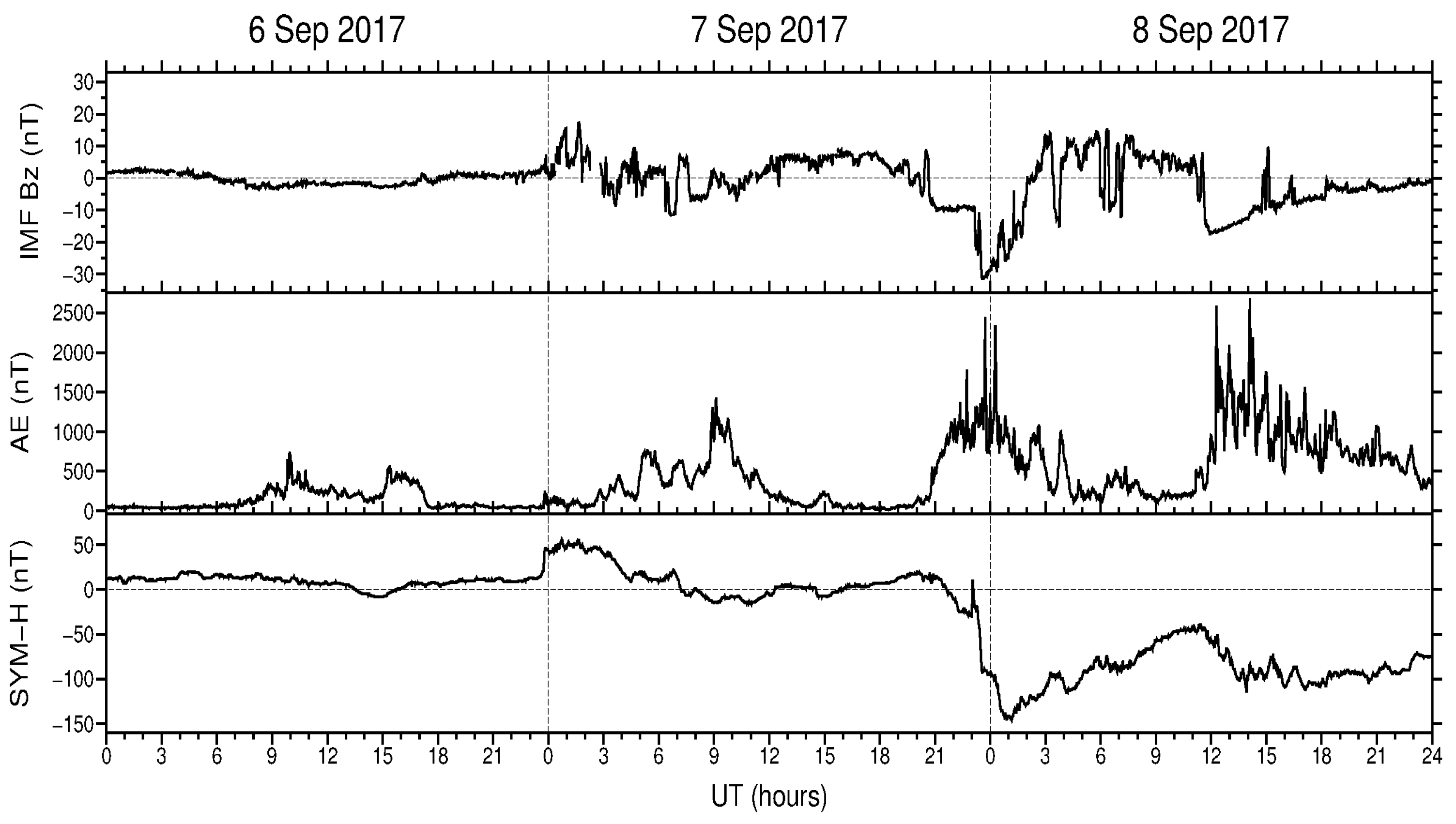
In this section, we analyze the signatures of the storm-induced ionospheric irregularities at high and midlatitudes that developed during the geomagnetic storm on 7–8 September 2017, which were detected in the GOES GEO RO ionospheric soundings. This storm occurred during a low solar activity period of the 24th solar cycle and can be classified as a moderate-to-severe level. Figure 2 demonstrates the geophysical conditions during this storm with variations in the interplanetary magnetic field (IMF) north–south component Bz, auroral electrojet (AE) index, and SYM-H index. These data were provided by the NASA OMNIWeb service (https://omniweb.gsfc.nasa.gov/ow_min.html, accessed on 4 July 2024).
The initial phase of this storm was characterized by the steady southward IMF Bz (Figure 2, top panel) and by a strong increase in the auroral electrojet (AE) index (Figure 2, middle panel) from ~21 UT on 7 September to 04 UT on 8 September with a maximum value up to ~1500 nT. The SYM-H index reached its minimum value of –145 nT around 1 UT on 8 September 2017 (Figure 2, bottom panel).
In order to review the overall ionospheric response to this geomagnetic storm in terms of ionospheric irregularity development, we analyzed the IGS polar ROTI maps. Figure 3 shows a visualization of the IGS (International GNSS Service) polar ROTI map product for three days from 6 September to 8 September 2017. These daily ROTI maps depict an overall pattern of the spatial distribution of the ionospheric irregularities across the Northern Hemisphere’s high and middle latitudes in the magnetic latitude–magnetic local time (MLAT–MLT) coordinate system. For the relatively quiet day of 6 September 2017 (Figure 3a), the ionospheric irregularities of low intensity were mainly detected near 75–80° MLAT on the dayside and ~70° MLAT on the nightside. The next day, 7 September 2017, was characterized by an increased level of auroral activity, and the AE index had peaks above 500–1000 nT during 05–11 UT and after the storm onset at ~21 UT. Figure 3b illustrates this intensification of auroral activity with a more distinct oval-like area of ionospheric irregularities detected over the polar region of the Northern Hemisphere between 65° and 75° MLAT. For the next day of geomagnetic storm development, 8 September 2017 (Figure 3c), the daily ROTI map shows a dramatic difference in comparison to the quiet-time day. In particular, the auroral ionospheric irregularities had high intensity (ROTI values equal or exceed 1.0 TECU/min, red color), and their spatial distribution formed a clear oval-like shape (similar to an auroral oval’s form seen in the satellite-based UV observations, e.g., [69,70]) that largely expanded toward the middle latitudes. The auroral irregularities’ oval expanded equatorward as far down as ~57° MLAT for the nighttime sector and 60–65° MLAT for the dayside.
Because the GPS receivers onboard GOES satellites were not configured optimally for RO, there is a small number of observations tracked below 1000 km tangent point altitude because these observations are considered “useless” for the GOES navigational solution due to the impact of the ionosphere. Thus, the final number of successful RO retrievals was quite limited for this reason. On average, there were only approximately five recoverable electron density profiles per day that met our minimum criteria for retrieval (continuous signal tracked from 2000 km to below 100 km tangent point). For the period of 7–8 September 2017, we have several fortunate occultation events from the GOES-16 geostationary GPS receiver with the tangent points located over the high and midlatitudes. To retrieve the signatures of the ionospheric irregularities, we analyzed the rate of change of the total electron content on the GOES GPS receiver–GPS transmitter links for successful radio occultation events when the electron density profiles were retrieved according to the methodology from [62].
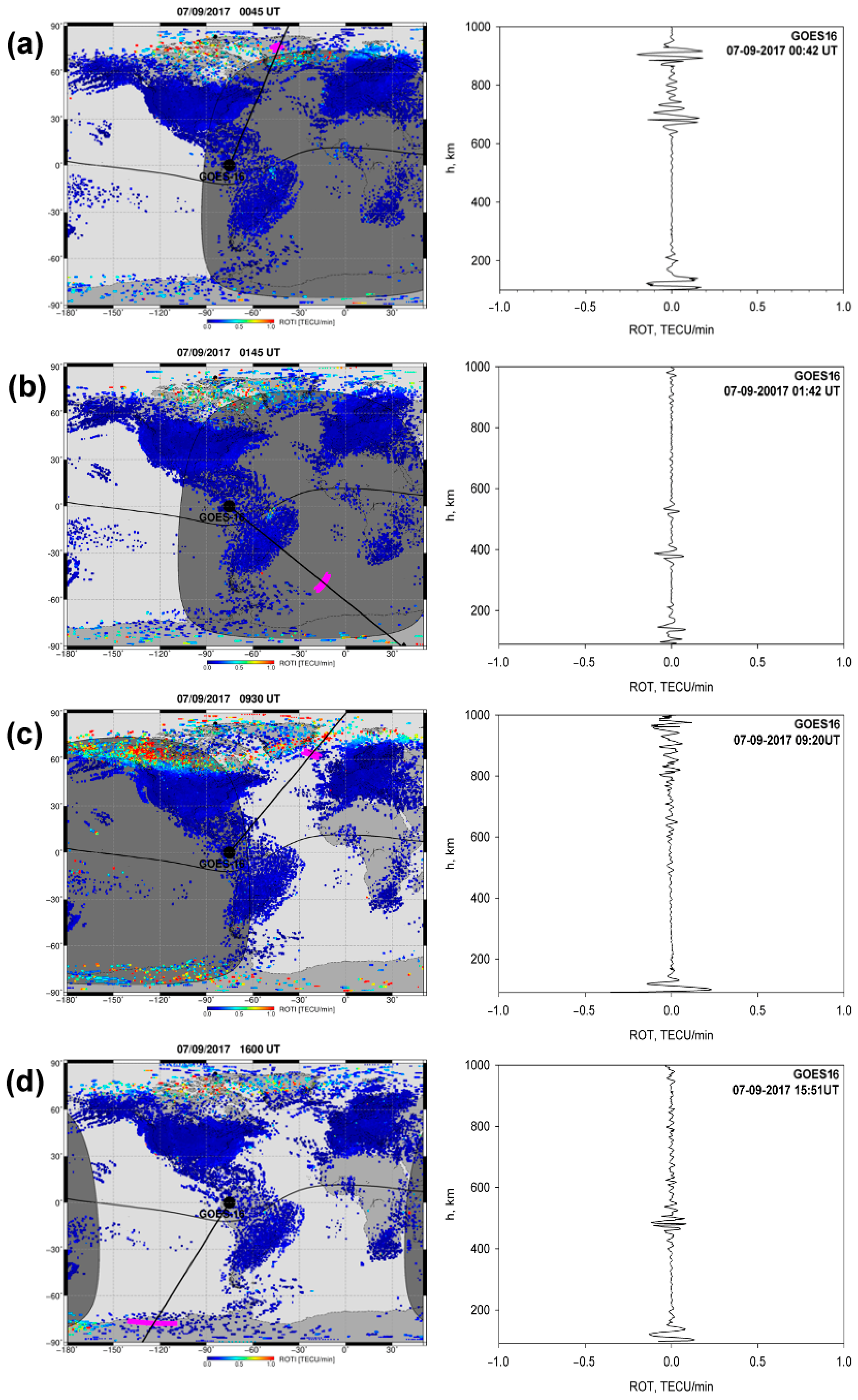
Prior to the main phase of this geomagnetic storm, four successful GOES RO events took place. Two events occurred at high latitudes of the Northern Hemisphere, near Greenland at 00:45 UT and 09:20 UT, and two in the Southern Hemisphere with tangent points (magenta dots) at midlatitudes over the Atlantic Ocean at around 01:42 UT and at high latitudes over Antarctica around 15:51 UT on 7 September 2017 (Figure 4).
The left panels on Figure 4 show a global distribution of the ionospheric irregularities’ occurrence as detected by ground-based GNSS ROTI observations before the storm’s main phase and for the temporal periods close to the GOES RO events. In addition, each geographical map shows projections of the GOES–16 position (black dot near the equator at 75.2° W longitude) and central line-of-sight link in the direction between the GOES GPS receiver and GPS transmitter (black line), which extends beyond the map due to the GEO–GPS geometry and location of the GPS satellite on the opposite side of the Earth (Figure 1). The right panels on Figure 4 show variations in the rate of the TEC (ROT) as derived from the GOES GPS measurement for several successful occultation events spanning an altitudinal range of 100–1000 km. The first set of ROTI maps for 7 September 2017, corresponding to the pre-storm conditions, shows quite typical results with a very low intensity of ionospheric irregularities (low ROTI values correspond to the scale blue marks) practically everywhere globally, with recognized intensification in ionospheric irregularities’ occurrence at high latitudes near the polar cap. The altitudinal variation in the ROT shows some variations in the TEC on the links between the GPS receiver onboard the geostationary GOES–16 and GPS transmitter with the first peak around 100–150 km, which correspond to the ionospheric E layer, and the second one close to the F2 layer ionization maximum, around 400 km. But the magnitude of these variations is quite small and does not exceed 0.2 TECU/min. These elevated ROT values can be explained by the normal quiet (or slightly disturbed) conditions when particle precipitations can occur at high latitudes and in the polar cusp region, which was confirmed by the corresponding ground-based ROTI maps (Figure 4a,c).
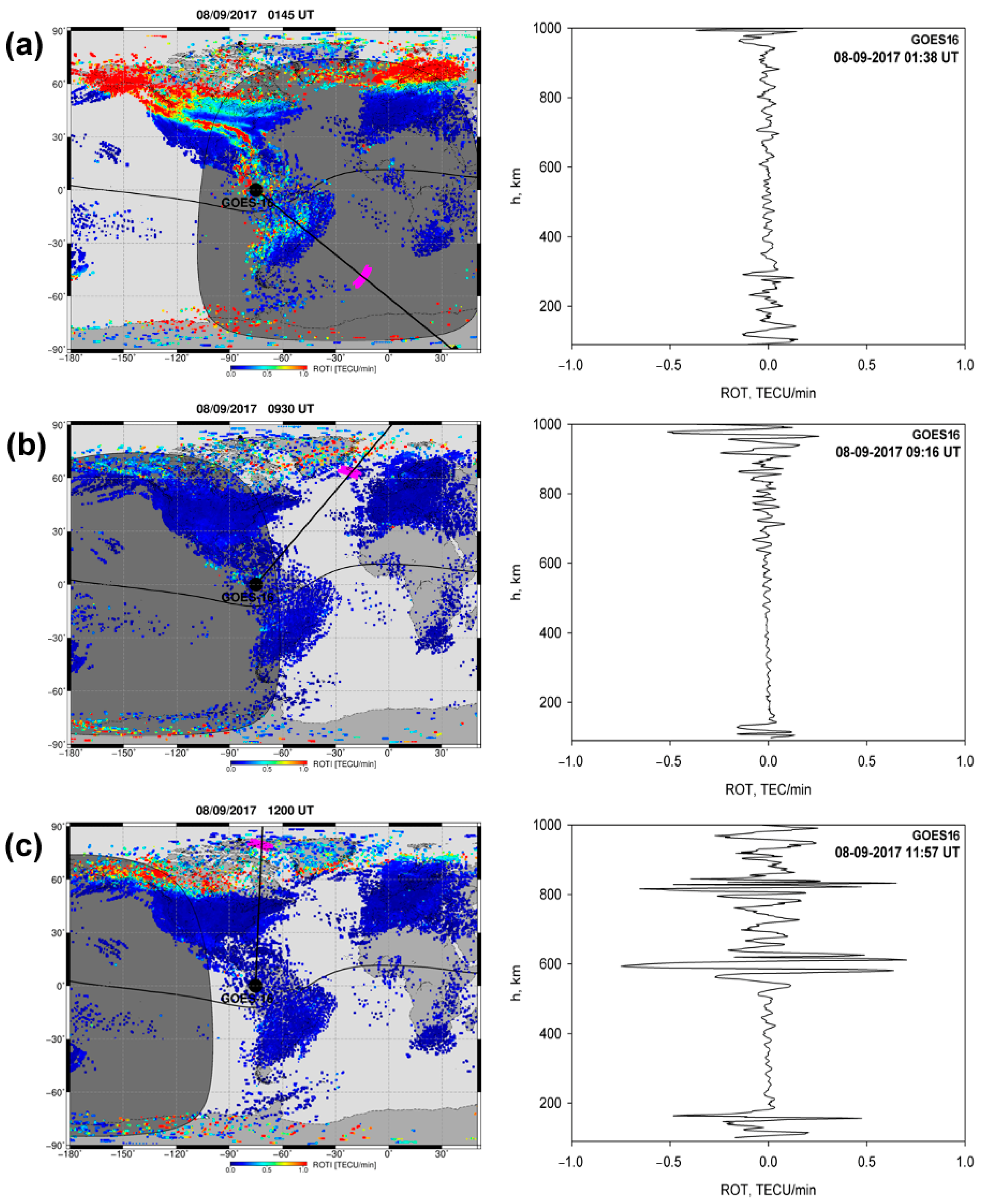
Figure 5, organized in the same way as Figure 4, presents the results corresponding to the main phase of the geomagnetic storm. For the day of 8 September 2017, when the main phase of the geomagnetic storm took place, the GOES RO events appeared near the same time and over the same areas as the ones on 7 September 2017. This is due to the rather repeatable GEO–GPS RO sounding geometry when the quasi-stationary GOES receiver tracked signals from the same GPS transmitter satellites, which have a small nodal orbit precession (~4 min per day). So, a comparison of the differences in the GOES RO sounding results will allow us to identify the signatures of the ionospheric irregularities induced by the geomagnetic activity.
With an increase in auroral activity (when the AE index exceeded 500 nT, see Figure 2), the global ROTI maps depicted a significant intensification of the ionospheric irregularities’ occurrence at high latitudes of both hemispheres. Later, with the storm development, the circle-like area with the strong ionospheric plasma irregularities of auroral origin extended noticeably in size and shifted toward midlatitudes as far as ~60° MLAT in the American and European sectors.
So, an examination of the ground-based GNSS observations confirms in general the development and intensification of the ionospheric plasma irregularities during the main phase of the storm over the midlatitudes and the geolocation of the areas affected by irregularities from high to midlatitudes over the Northern America continent, as well as over Antarctica. The tangent point locations of the GOES RO soundings corresponded to areas with ionospheric irregularities detected by ground-based GNSS ROTI maps, as presented in Figure 4 and Figure 5. It is interesting that for the day of 7 September 2017, before the storm onset, the ionospheric irregularities were detected at the high latitudes near Greenland, and the GOES RO soundings also showed signatures of ionospheric gradients in the altitude-temporal ROT values (Figure 4a,c).

3.2. Case-Study of Geomagnetic Storm on 25–26 August 2018

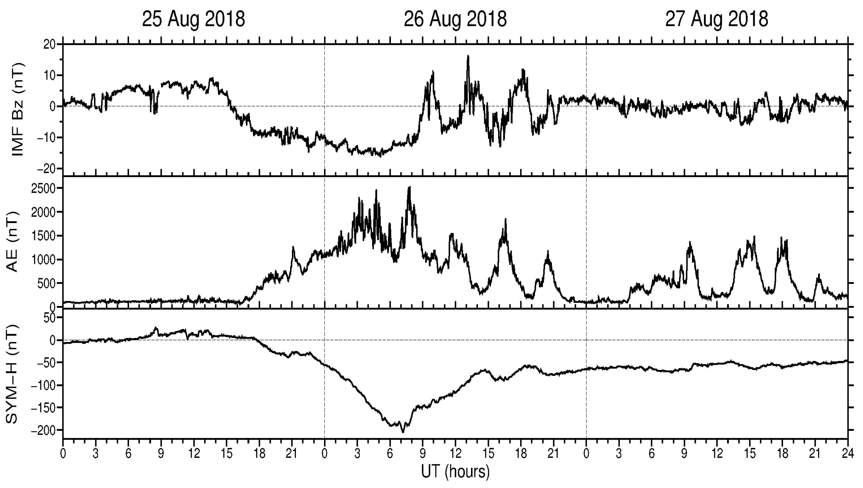
Following a similar approach, we examined the GOES GEO RO data to identify the signatures of the storm-induced ionospheric irregularities for the case of the August 2018 geomagnetic storm. This event occurred on 25–26 August 2018, and it was one of the biggest geostorms in the 24th solar cycle (SYM-H min –206 nT). Figure 6 shows the geophysical conditions with variations in the IMF Bz and AE and SYM-H indexes during 25–27 August 2018. The IMF Bz southward turning occurred after 14 UT on 25 August 2018. The main phase of the geomagnetic storm started to develop after ~17:30 UT on 25 August. The SYM-H index reached its minimum of −206 nT at ~07 UT on 26 August. The auroral electrojet AE index exceeded 500 nT after 18 UT on 25 August, and the AE peaks with values up to 1500–2000 nT were registered during 02–09 UT on 26 August 2018.
Figure 7 presents the IGS polar ROTI maps illustrating the overall pattern of the storm-induced ionospheric irregularity development during the August 2018 geomagnetic storm. For the rather quiet day of 25 August 2018 (Figure 7a), the area affected by the ionospheric irregularities was within 80° MLAT on the dayside and 70–72° MLAT on the nightside, with the highest intensity of the ROTI occurring between 19 and 22 MLT. For the day of the main phase of the geomagnetic storm, 26 August 2018 (Figure 7b), the daily ROTI map shows a significant contrast in comparison to the previous day. In particular, the auroral ionospheric irregularities had high intensity (ROTI values equal to or exceeding 1.0 TECU/min, red color on the map), and their spatial distribution formed a clearer oval-like shape largely expanded in size. The auroral irregularities’ oval expanded equatorward as far down as ~55° MLAT for the nighttime sector and 60–65° MLAT for the dayside. For the day with the storm’s recovery phase, the daily ROTI maps depicted that the auroral irregularities’ zone was greatly diminished in size and intensity (Figure 7c).
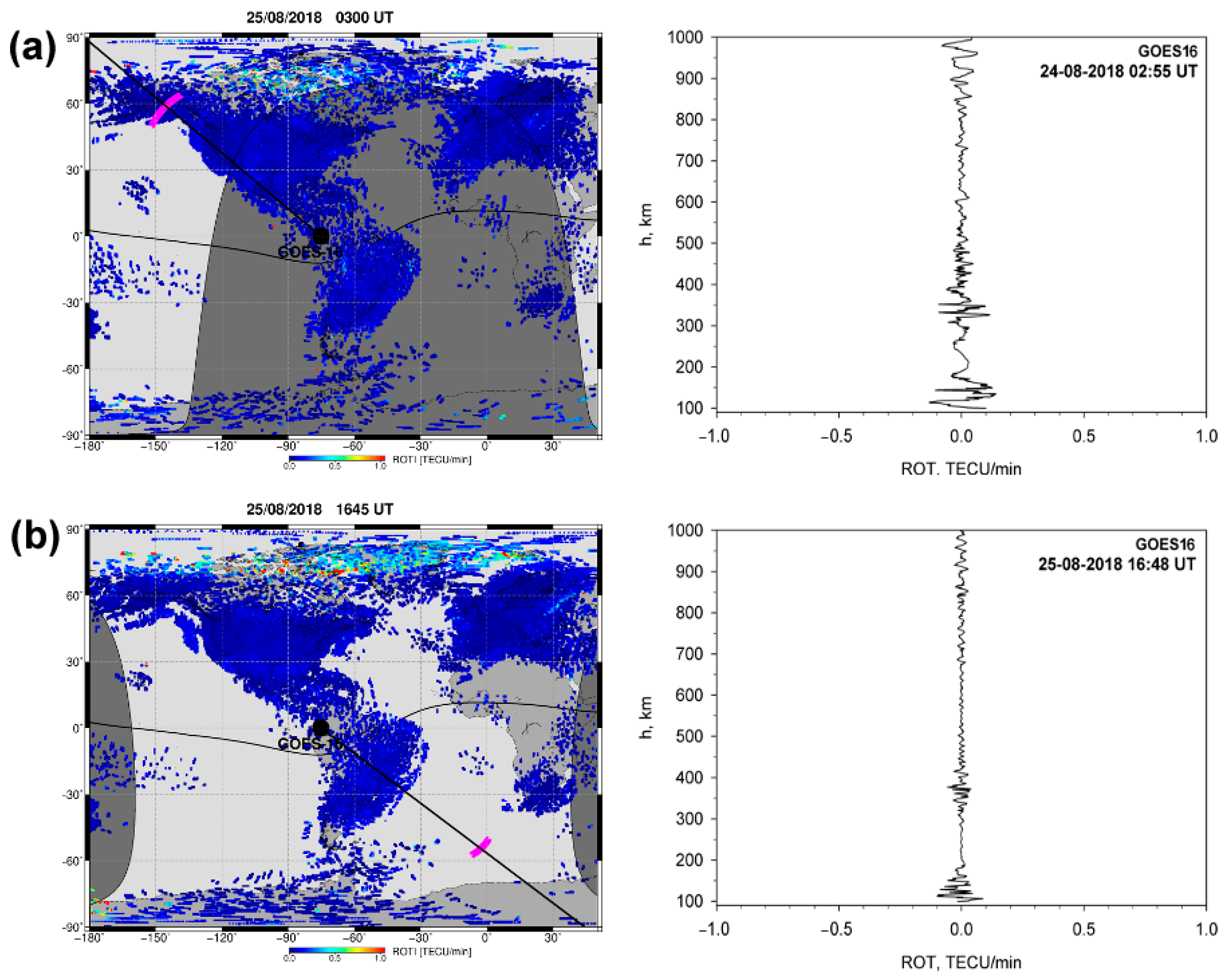
For the period of 25–26 August 2018, we also obtained several successful occultations from observations provided by the geostationary GPS receiver onboard GOES-16. Figure 8 presents the details of the ionospheric irregularities’ signatures in the GOES GPS observations specified by the ROT and the ionospheric irregularities’ occurrence on a global scale as specified by ground-based ROTI measurements before the geomagnetic storm onset at ~17:30 UT on 25 August 2018. The corresponding ROTI maps illustrate the lack or extremely weak presence of ionospheric irregularities (blue-colored ROTI values) across the globe, with some increased activity in the high latitudes in the dayside region. There were two GOES RO events that occurred at 02:55 UT and 16:48 UT on 25 August 2018 in the opposite hemispheres near 60° N and 60° S, respectively. The altitudinal-temporal variations in the ROT along the GOES RO links were also quite small. During both occultations, the ROT values indicate some fluctuations in the TEC on the links connecting the geostationary GOES to the GPS transmitters on the opposite side of the Earth. The largest ROT values with a magnitude of 0.1–0.15 TECU/min were concentrated at ~100–150 km altitude near the E layer and at ~300–400 km altitudes corresponding to the typical location of the F2 layer ionization peak. Similar to those observed in the September 2017 pre-storm cases, these ROT variations can be explained by the normal quiet-time plasma density gradients on the GOES-GPS links passing through the polar region.
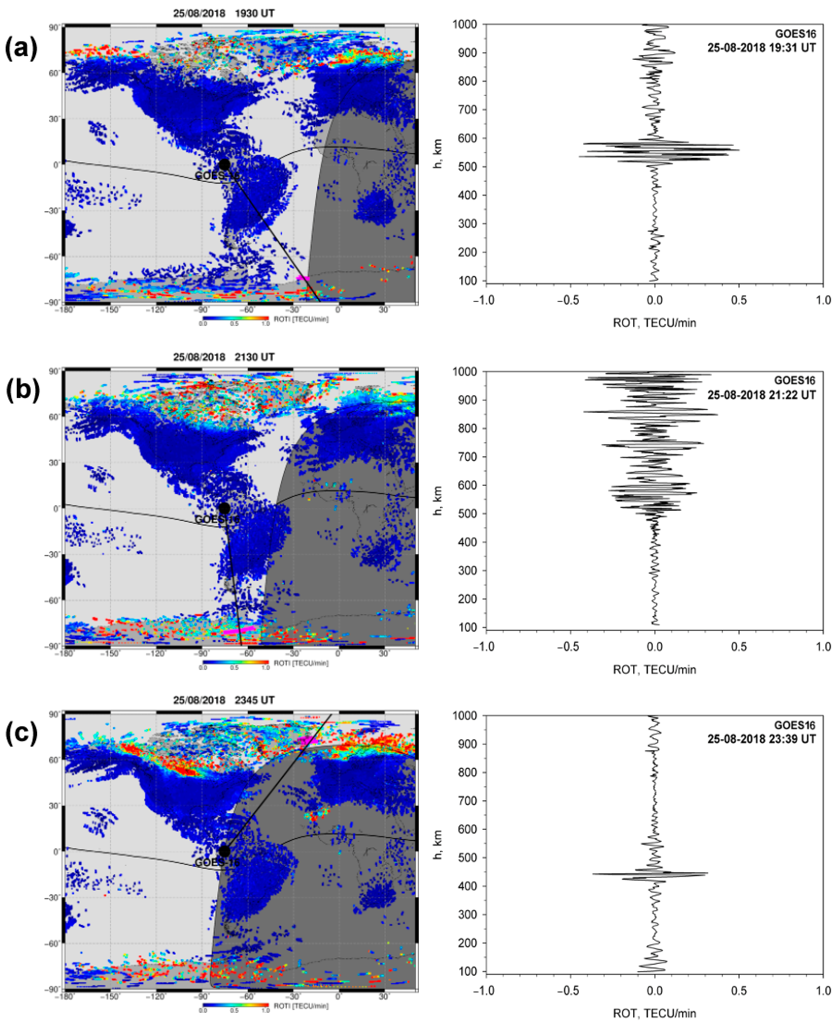
As the geomagnetic storm started after ~17:30 UT on 25 August followed by a rapid increase in auroral activity with the AE index rising from 500 nT to 1500 nT during the main phase of the storm, the global ROTI map depicts a significant intensification of the ionospheric irregularities’ occurrence at high latitudes of both hemispheres (Figure 9). Later, as the storm developed, the belt-like area with the strong ionospheric irregularities of auroral origin largely expanded in size and moved equatorward toward the midlatitudes as far as ~60° MLAT in the American and European sectors (Figure 9c, left). Here, we have three successful GOES occultations corresponding to the storm’s main phase development during 25 August (Figure 9). The first one occurred at ~19:31 UT with the tangent points located at ~25° W longitude near the Antarctica region. The second RO event occurred at ~21:22 UT with tangent points near 60–70° W close to Antarctic Peninsula. The third one took place at 23:39 UT near 73° N, 20° W in the Northern Hemisphere. During the first occultation (Figure 9a), we have rapid TEC variations described by the ROT with a magnitude up to 0.5 TECU/min. These intense ROT variations were primarily observed above the F2 layer ionization peak within the altitude range of 450–600 km. For the second occultation at ~21:22 UT (Figure 9b), the intense fluctuations in the altitudinal ROT were registered from ~450 up to 1000 km of the tangent point altitude. For the third occultation at ~23:39 UT near Greenland (Figure 9c), the intense fluctuations in the altitudinal ROT were mainly concentrated within a 400–450 km altitudinal range. The ROTI maps corresponding to these cases confirmed the presence of ionospheric irregularities near the area of the tangent point location along the line-of-sight links directed from the GOES location to the GPS transmitter on the opposite side of the Earth.
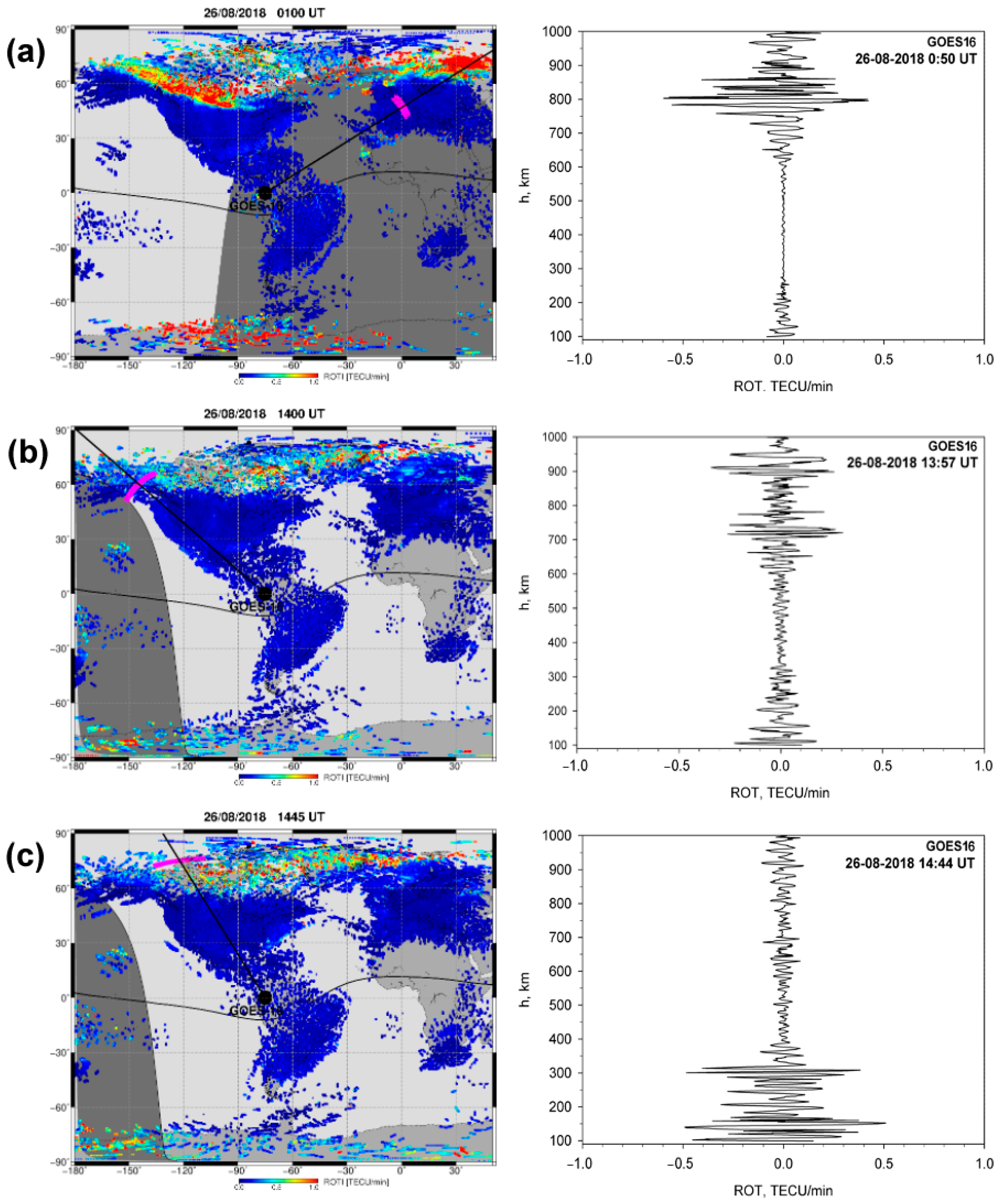
During the next day, 26 August 2018, the storm main phase lasted until ~07 UT and then the recovery phase started. For this day, we have six successful GOES RO events (Figure 10 and Figure 11). The first event occurred at ~00:50 UT with tangent points over Western Europe (Figure 10a). The altitudinal ROT from the GOES data indicated the presence of TEC gradients with a peak intensity near 0.5 TECU/min in the topside ionosphere within an altitudinal range of 650–900 km. The corresponding GNSS ROTI map (Figure 10a, left) shows the presence of intense auroral irregularities in the eastern European sector, located farther than the tangent points. Two other events happened relatively close to each other during the storm’s recovery phase: one at 13:57 UT near 145° W longitude in the Alaska region and the second one at 14:44 UT near 120° W longitude in Canada (Figure 10b,c). For the case of ~13:57 UT, the intense ROT fluctuations were predominant within the altitudinal range of 600–900 km, whereas for the second case at ~14:44 UT, the fluctuations appeared mainly in the bottomside ionosphere at tangent point altitudes between 100 and 350 km. The ROTI maps (Figure 10b,c, left) provided confirmation of the ionospheric irregularities’ existence over sub-auroral latitudes in Northern America during these periods, and the GOES RO tangent points were located in close proximity to areas affected by ionospheric irregularities, as specified by the ground-based GNSS ROTI.
Later, into the storm recovery phase, two GOES RO events occurred at ~16:46 UT and 19:27 UT in the Atlantic sector in the Southern Hemisphere and another one at 23:34 UT in Northern Europe (Figure 11). For the first two cases, the signatures of the ionospheric irregularities on the GOES-GPS link were detected in the topside ionosphere within the altitudinal range of tangent points of 800–1000 km and 700–1000 km, respectively. The GNSS ROTI maps corresponding to these periods of time depicted the presence of ionospheric irregularities in the auroral zone in the general line-of-sight direction from the GOES to GPS and relatively close to the locations of the tangent point projection of these occultations.
The last RO case at 23:34 UT (Figure 11c) shows minimal TEC fluctuations along the GOES–GPS link, with slight intensification of the ROT near ~120 km altitude (ionospheric E layer) and in the topside ionosphere within a 700–1000 km interval, but here the ROT values did not surpass 0.1 TECU/min. The ground-based ROTI map corresponding to this temporal interval demonstrates that extremely weak ionospheric irregularities persisted at the high latitudes. During this time, the geomagnetic indicators (Bz, Ae, and SYM-H on Figure 6) did not exhibit any significant disturbances and the ionospheric state was transitioning back to normal conditions.
The presented GOES RO results emphasize the known and important problem of geolocating ionospheric irregularities in remote sensing. The ionospheric plasma irregularities can be reliably detected along the line of sight between the GNSS transmitter and the receiver. But determining the precise location of ionospheric irregularities along this direction is still a challenging task. For the traditional LEO RO geometry, the simplest and widely used approach is to assign the location of the detected ionospheric irregularities to the tangent point (the point along the line closest to the surface), e.g., [71,72]. For several cases that we examined for GOES RO (e.g., Figure 10a), this assumption does not work well when the irregularities assigned to the tangent point location were found to be rather distant from the area of the irregularities detected from the ground-based observations. There exist several approaches for more accurate localization of the ionospheric irregularities along the line-of-sight GNSS transmitter–receiver, which are based on the phase screen [73] or back propagation method [59,74]. But all these methods require high-rate 50–100 Hz sampling of the RO signal to capture the spectrum of scintillation. The GPS receivers currently used onboard the GOES satellites were not designed for high-rate RO signal tracking, and GOES-based GPS observations do not allow us to apply these approaches for accurate localization of the ionospheric irregularities. However, incorporating this option to the future versions of the GOES payload will open up new possibilities not only to detect but also accurately localize ionospheric plasma irregularities on links between the geostationary GOES GPS receiver and GPS transmitter on the opposite side of the Earth.
Our investigations of GPS RO opportunities from geostationary orbit for ionosphere soundings demonstrates that including an RO remote sensing payload as a scientific instrument will extend the GOES satellite monitoring capability of the near-Earth plasma environment and space weather. These new RO observations, when combined with the GOES Extreme Ultraviolet, X-ray, and Space Environment In Situ Suite detectors, will contribute to a deeper understanding of how the ionosphere responds to space weather.

4. Conclusions

In this paper, we present the promising results of ionospheric irregularity detection using new data from GPS receivers operating on the geostationary orbit GOES–16. The GPS receivers onboard GOES satellites can track GPS signals propagated through the Earth’s ionosphere and can be used to analyze rapid variations in the TEC on these links, which can be caused by ionospheric plasma gradients and ionospheric irregularities. Using the novel geostationary GOES GPS observations, we examined the signatures of the ionospheric irregularities’ occurrence for two major geomagnetic storms that occurred in September 2017 and August 2018. The presence of ionospheric plasma density irregularities in the vicinity of the GOES GPS RO sounding field of view during the main phases of both geomagnetic storms and their absence during the quiet pre-storm conditions were confirmed by the ROTI maps constructed with multi-station ground-based GNSS observations. The ROTI maps depicted the generation and evolution of the storm-induced ionospheric irregularities and their occurrence near the GOES GPS RO sounding tangent points in the examined events. The actual GPS receivers operated on GOES satellites were not designed for RO ionospheric observations and have limitations in the numbers of tracking channels and data outputs available. But even such limited observations from “signals of opportunity” allowed us to detect signatures of the ionospheric irregularities by applying techniques proven for irregularity detection tasks with the ground-based GNSS observations.
Taking into consideration the unique geometry of the GEO–GPS RO links from the geostationary orbit, with a repeatable pattern of ionospheric sounding from day to day, this type of observation can provide advantages for continuous irregularity monitoring over specific areas where traditional facilities cannot operate. There is great potential of RO observations from geostationary orbit to provide unique spatio-temporal coverage for ionospheric irregularity monitoring that can be realized in the future in upcoming geostationary satellites with new generations of receivers able to track different GNSS constellations. In combination with other Space Environment payloads, these new RO observations will allow for extending the GOES capabilities for ionosphere and space weather monitoring.

Author Contributions

Conceptualization and methodology, I.C., I.Z., S.G. and D.H.; software, I.C., I.Z. and D.H; visualization and investigation, I.C. and I.Z.; validation and analysis, I.C., I.Z. and D.H.; writing—original draft preparation, I.C., I.Z., S.G. and D.H.; writing—review and editing, I.C.; funding acquisition, S.G. and I.C. All authors have read and agreed to the published version of the manuscript.

Funding

This research was funded by the National Aeronautics and Space Administration (NASA) Research Opportunities in Space and Earth Science (ROSES) 2019 under Grant 80NSSC20K1733. The GNSS data collection, generation, and analysis of multi-station ground-based GNSS ROTI maps was funded by the National Science Centre, Poland, grant No. 2022/47/B/ST10/01766.

Institutional Review Board Statement

Not applicable.

Informed Consent Statement

Not applicable.

Data Availability Statement

The geophysical data are available at NASA/GSFC’s Space Physics Data Facility’s OMNIWeb service for geophysical parameters data (https://omniweb.gsfc.nasa.gov/ow_min.html). The GNSS data are available from SONEL (ftp://ftp.sonel.org/gps/data), CORS (https://geodesy.noaa.gov/corsdata), EUREF (ftp://gnss.bev.gv.at/pub/obs/), Natural Resources Canada (webapp.geod.nrcan.gc.ca), SOPAC (ftp://garner.ucsd.edu), TrigNET (ftp://ftp.trignet.co.za), RBMC Brazil (https://geoftp.ibge.gov.br/informacoes_sobre_posicionamento_geodesico/rbmc/), and RAMSAC (https://www.ign.gob.ar/NuestrasActividades/Geodesia/Ramsac/DescargaRinex). The IGS ROTI polar maps are available at IGS CDDIS (https://cddis.nasa.gov/archive/gps/products/ionex/). The access date is 4 July 2024.

Acknowledgments

The authors acknowledge NASA (Doug Freesland, Alexander Krimchansky, and Joel McCorkel) and the Lockheed Martin Corporation (Graeme Ramsey, Jim Chapel) for providing the GOES GPS observations and support during the NASA ROSES project.

Conflicts of Interest

The authors declare no conflicts of interest. The funders had no role in the design of the study; in the collection, analyses, or interpretation of the data; in the writing of the manuscript; or in the decision to publish the results.

References

  1. Doherty, P.H.; Delay, S.H.; Valladares, C.E.; Klobuchar, J.A. Ionospheric scintillation effects on GPS in the equatorial and auroral regions. Navigation 2003, 50, 235–245. [Google Scholar] [CrossRef]
  2. Basu, S.; Groves, K.M.; Basu, S.; Sultan, P.J. Specification and forecasting of scintillations in communication/navigation links: Current status and future plans. J. Atmos. Solar-Terrestrial Phys. 2002, 64, 1745–1754. [Google Scholar] [CrossRef]
  3. Dubey, S.; Wahi, R.; Gwal, A. Ionospheric effects on GPS positioning. Adv. Space Res. 2006, 38, 2478–2484. [Google Scholar] [CrossRef]
  4. Kintner, P.M.; Ledvina, B.M.; De Paula, E.R. GPS and ionospheric scintillations. Space Weather. 2007, 5, S09003. [Google Scholar] [CrossRef]
  5. Kelly, M.A.; Comberiate, J.M.; Miller, E.S.; Paxton, L.J. Progress toward forecasting of space weather effects on UHF SATCOM after Operation Anaconda. Space Weather. 2014, 12, 601–611. [Google Scholar] [CrossRef]
  6. Morton, Y.J.; Yang, Z.; Breitsch, B.; Bourne, H.; Rino, C. Ionospheric Effects, Monitoring, and Mitigation Techniques. In Position, Navigation, and Timing Technologies in the 21st Century; Morton, Y.T.J., Diggelen, F., Spilker, J.J., Parkinson, B.W., Lo, S., Gao, G., Eds.; Wiley-IEEE Press: Hoboken, NJ, USA, 2020; pp. 879–937. [Google Scholar] [CrossRef]
  7. Kudeki, E.; Basu, S.; Valladares, C.E.; Weber, E.J.; Zengingonul, H.P.; Bhattacharyya, S.; Sheehan, R.; Meriwether, J.W.; Biondi, M.A.; Kuenzler, H.; et al. Scintillations, plasma drifts, and neutral winds in the equatorial ionosphere after sunset. J. Geophys. Res. Space Phys. 1996, 101, 26795–26809. [Google Scholar] [CrossRef]
  8. Groves, K.M.; Basu, S.; Weber, E.J.; Smitham, M.; Kuenzler, H.; Valladares, C.E.; Sheehan, R.; MacKenzie, E.; Secan, J.A.; Ning, P.; et al. Equatorial scintillation and systems support. Radio Sci. 1997, 32, 2047–2064. [Google Scholar] [CrossRef]
  9. Basu, S. Equatorial scintillations—A review. J. Atmos. Solar-Terrestrial Phys. 1981, 43, 473–489. [Google Scholar] [CrossRef]
  10. Huang, C.S.; De La Beaujardiére, O.; Roddy, P.A.; Hunton, D.E.; Liu, J.Y.; Chen, S.P. Occurrence probability and amplitude of equatorial ionospheric irregularities associated with plasma bubbles during low and moderate solar activities (2008–2012). J. Geophys. Res. Space Phys. 2014, 119, 1186–1199. [Google Scholar] [CrossRef]
  11. Ossakow, S.L. Spread F theories: A review. J. Atmos. Terr. Phys. 1981, 43, 437–552. [Google Scholar] [CrossRef]
  12. Woodman, R.; La Hoz, C. Radar observations of F region equatorial irregularities. J. Geophys. Res. 1976, 81, 5447–5466. [Google Scholar] [CrossRef]
  13. Tsunoda, R.T.; Livingston, R.C.; McClure, J.P.; Hanson, W.B. Equatorial plasma bubbles: Vertically elongated wedges from the bottomside F layer. J. Geophys. Res. 1982, 87, 9171–9180. [Google Scholar] [CrossRef]
  14. Kelley, M. The Earth’s Ionosphere; Academic Press: San Diego, CA, USA, 1989; 487p. [Google Scholar]
  15. Tsunoda, R.T. High-latitude F region irregularities: A review and synthesis. Rev. Geophys. 1988, 26, 719–760. [Google Scholar] [CrossRef]
  16. Phelps, A.D.R.; Sagalyn, R.C. Plasma density irregularities in the high- latitude top side ionosphere. J. Geophys. Res. 1976, 81, 515–523. [Google Scholar] [CrossRef]
  17. Keskinen, M.J.; Ossakow, S.L. Theories of high-latitude ionospheric irregularities: A review. Radio Sci. 1983, 18, 1077–1091. [Google Scholar] [CrossRef]
  18. Fejer, B.G.; Kelley, M.C. Ionospheric irregularities. Rev. Geophys. 1980, 18, 401–454. [Google Scholar] [CrossRef]
  19. Huang, C.Y.; Burke, W.J.; Machuzak, J.S.; Gentile, L.C.; Sultan, P.J. Equatorial plasma bubbles observed by DMSP satellites during a full solar cycle: Toward a global climatology. J. Geophys. Res. Space Phys. 2002, 107, SIA 7-1–SIA 7-10. [Google Scholar] [CrossRef]
  20. Burke, W.J.; Gentile, L.C.; Huang, C.Y.; Valladares, C.E.; Su, S.Y. Longitudinal variability of equatorial plasma bubbles observed by DMSP and ROCSAT-1. J. Geophys. Res. Space Phys. 2004, 109, A12301. [Google Scholar] [CrossRef]
  21. Huang, C.S.; de La Beaujardiere, O.; Roddy, P.A.; Hunton, D.E.; Pfaff, R.F.; Valladares, C.E.; Ballenthin, J.O. Evolution of equatorial ionospheric plasma bubbles and formation of broad plasma depletions measured by the C/NOFS satellite during deep solar minimum. J. Geophys. Res. 2011, 116, A03309. [Google Scholar] [CrossRef]
  22. Yizengaw, E.; Groves, K.M. Longitudinal and Seasonal Variability of Equatorial Ionospheric Irregularities and Electrodynamics. Space Weather. 2018, 16, 946–968. [Google Scholar] [CrossRef]
  23. Su, S.Y.; Liu, C.H.; Ho, H.H.; Chao, C.K. Distribution characteristics of topside ionospheric density irregularities: Equatorial versus midlatitude regions. J. Geophys. Res. Space Phys. 2006, 111, A06305. [Google Scholar] [CrossRef]
  24. Xiong, C.; Park, J.; Lühr, H.; Stolle, C.; Ma, S.Y. Comparing plasma bubble occurrence rates at CHAMP and GRACE altitudes during high and low solar activity. Ann. Geophys. 2010, 28, 1647–1658. [Google Scholar] [CrossRef]
  25. Zakharenkova, I.; Astafyeva, E.; Cherniak, I. GPS and in situ Swarm observations of the equatorial plasma density irregularities in the topside ionosphere. Earth Planets Space 2016, 68, 1. [Google Scholar] [CrossRef]
  26. Zakharenkova, I.; Cherniak, I.; Braun, J.J.; Wu, Q. Global Maps of Equatorial Plasma Bubbles Depletions Based on FORMOSAT-7/COSMIC-2 Ion Velocity Meter Plasma Density Observations. Space Weather. 2023, 21, e2023SW003438. [Google Scholar] [CrossRef]
  27. Aarons, J.; Mendillo, M.; Yantosca, R. GPS phase fluctuations in the equatorial region during sunspot minimum. Radio Sci. 1997, 32, 1535–1550. [Google Scholar] [CrossRef]
  28. Pi, X.; Mannucci, A.J.; Lindqwister, U.J.; Ho, C.M. Monitoring of global ionospheric irregularities using the worldwide GPS network. Geophys. Res. Lett. 1997, 24, 2283–2286. [Google Scholar] [CrossRef]
  29. Basu, S.; Groves, K.M.; Quinn, J.M.; Doherty, P. A comparison of TEC fluctuation and scintillations at Ascension Island. J. Atmos. Sol. Terr. Phys. 1999, 61, 1219–1226. [Google Scholar] [CrossRef]
  30. Beach, T.L.; Kintner, P.M. Simultaneous Global Position System observations of equatorial scintillations and total electron content fluctuations. J. Geophys. Res. 1999, 104, 22553–22565. [Google Scholar] [CrossRef]
  31. Jakowski, N.; Béniguel, Y.; De Franceschi, G.; Pajares, M.H.; Jacobsen, K.S.; Stanislawska, I.; Tomasik, L.; Warnant, R.; Wautelet, G. Monitoring, tracking and forecasting ionospheric perturbations using GNSS techniques. J. Space Weather. Space Clim. 2012, 2, A22. [Google Scholar] [CrossRef]
  32. Krankowski, A.; Shagimuratov, I.; Baran, L.; Efishov, I.; Tepenitzyna, N. The occurrence of polar cap patches in TEC fluctuations detected using GPS measurements in southern hemisphere. Adv. Space Res. 2006, 38, 2601–2609. [Google Scholar] [CrossRef]
  33. Shagimuratov, I.I.; Krankowski, A.; Ephishov, I.; Cherniak, Y.; Wielgosz, P.; Zakharenkova, I. High latitude TEC fluctuations and irregularity oval during geomagnetic storms. Earth Planets Space 2012, 64, 521–529. [Google Scholar] [CrossRef]
  34. Jacobsen, K.S. The impact of different sampling rates and calculation time intervals on ROTI values. J. Space Weather. Space Clim. 2014, 4, A33. [Google Scholar] [CrossRef]
  35. Prikryl, P.; Ghoddousi-Fard, R.; Weygand, J.M.; Viljanen, A.; Connors, M.; Danskin, D.W.; Jayachandran, P.T.; Jacobsen, K.S.; Andalsvik, Y.L.; Thomas, E.G.; et al. GPS phase scintillation at high latitudes during the geomagnetic storm of 17–18 March 2015. J. Geophys. Res. Space Phys. 2016, 121, 10,448–10,465. [Google Scholar] [CrossRef]
  36. Jacobsen, K.S.; Andalsvik, Y.L. Overview of the 2015 St. Patrick’s day storm and its consequences for RTK and PPP positioning in Norway. J. Space Weather. Space Clim. 2016, 6, A9. [Google Scholar] [CrossRef]
  37. Shagimuratov, I.; Filatov, M.; Efishov, I.; Zakharenkova, I.E.; Tepenitsyna, N.Y. Fluctuations in the Total Electron Content and Errors in GPS Positioning Caused by Polar Auroras during the Auroral Disturbance of September 27, 2019. Bull. Russ. Acad. Sci. Phys. 2021, 85, 318–323. [Google Scholar] [CrossRef]
  38. Alfonsi, L.; Spogli, L.; Tong, J.; De Franceschi, G.; Romano, V.; Bourdillon, A.; Le, H.; Mitchell, C. GPS scintillation and TEC gradients at equatorial latitudes in April 2006. Adv. Space Res. 2011, 47, 1750–1757. [Google Scholar] [CrossRef]
  39. Alfonsi, L.; Spogli, L.; Pezzopane, M.; Romano, V.; Zuccheretti, E.; De Franceschi, G.; Cabrera, M.A.; Ezquer, R.G. Comparative analysis of spread-F signature and GPS scintillation occurrences at Tucumán, Argentina. J. Geophys. Res. Space Phys. 2013, 118, 4483–4502. [Google Scholar] [CrossRef]
  40. Sripathi, S.; Kakad, B.; Bhattacharyya, A. Study of equinoctial asymmetry in the Equatorial Spread F (ESF) irregularities over Indian region using multi-instrument observations in the descending phase of solar cycle 23. J. Geophys. Res. 2011, 116, A11302. [Google Scholar] [CrossRef]
  41. de Jesus, R.; Sahai, Y.; Fagundes, P.R.; de Abreu, A.; Brunini, C.; Gende, M.; Bittencourt, J.; Abalde, J.; Pillat, V. Response of equatorial, low- and mid-latitude F-region in the American sector during the intense geomagnetic storm on 24–25 October 2011. Adv. Space Res. 2013, 52, 147–157. [Google Scholar] [CrossRef]
  42. Yang, Z.; Liu, Z. Low-latitude ionospheric density irregularities and associated scintillations investigated by combining COSMIC RO and ground-based Global Positioning System observations over a solar active period. J. Geophys. Res. Space Phys. 2018, 123, 3998–4014. [Google Scholar] [CrossRef]
  43. Cherniak, I.; Krankowski, A.; Zakharenkova, I. Observation of the ionospheric irregularities over the Northern Hemisphere: Methodology and service. Radio Sci. 2014, 49, 653–662. [Google Scholar] [CrossRef]
  44. Cherniak, I.; Krankowski, A.; Zakharenkova, I. ROTI Maps: A new IGS ionospheric product characterizing the ionospheric irregularities occurrence. GPS Solut. 2018, 22, 69. [Google Scholar] [CrossRef]
  45. Cherniak, I.; Zakharenkova, I.; Krankowski, A. IGS ROTI Maps: Current Status and Its Extension towards Equatorial Region and Southern Hemisphere. Sensors 2022, 22, 3748. [Google Scholar] [CrossRef] [PubMed]
  46. Hajj, G.A.; Romans, L.J. Ionospheric electron density profiles obtained with the Global Positioning System: Results from the GPS/MET experiment. Radio Sci. 1998, 33, 175–190. [Google Scholar] [CrossRef]
  47. Schreiner, W.S.; Sokolovskiy, S.V.; Rocken, C.; Hunt, D.C. Analysis and validation of GPS/MET radio occultation data in the ionosphere. Radio Sci. 1999, 34, 949–966. [Google Scholar] [CrossRef]
  48. Jakowski, N.; Wehrenpfennig, A.; Heise, S.; Reigber, C.; Lühr, H.; Grunwaldt, L.; Meehan, T.K. GPS radio occultation measurements of the ionosphere from CHAMP: Early results. Geophys. Res. Lett. 2002, 29, 1457. [Google Scholar] [CrossRef]
  49. Heise, S.; Jakowski, N.; Cooke, D. Ionosphere/Plasmasphere Imaging Based on GPS Navigation Measurements from CHAMP and SAC-C. In Earth Observation with CHAMP; Reigber, C., Lühr, H., Schwintzer, P., Wickert, J., Eds.; Springer: Berlin, Heidelberg, 2005. [Google Scholar] [CrossRef]
  50. Shume, E.B.; Komjathy, A.; Langley, R.B.; Verkhoglyadova, O.; Butala, M.D.; Mannucci, A.J. Intermediate-scale plasma irregularities in the polar ionosphere inferred from GPS radio occultation. Geophys. Res. Lett. 2015, 42, 688–696. [Google Scholar] [CrossRef]
  51. Pedatella, N.M.; Yue, X.; Schreiner, W.S. Comparison between GPS radio occultation electron densities and in situ satellite observations. Radio Sci. 2015, 50, 518–525. [Google Scholar] [CrossRef]
  52. Habarulema, J.B.; Katamzi, Z.T.; Yizengaw, E. A simultaneous study of ionospheric parameters derived from FORMOSAT-3/COSMIC, GRACE, and CHAMP missions over middle, low, and equatorial latitudes: Comparison with ionosonde data. J. Geophys. Res. Space Phys. 2014, 119, 7732–7744. [Google Scholar] [CrossRef]
  53. Jakowski, N.; Wilken, V.; Mayer, C. Space weather monitoring by GPS measurements on board CHAMP. Space Weather. 2007, 5, S08006. [Google Scholar] [CrossRef]
  54. Yue, X.; Schreiner, W.S.; Pedatella, N.; Anthes, R.A.; Mannucci, A.J.; Straus, P.R.; Liu, J. Space weather observations by GNSS radio occultation: From FORMOSAT-3/COSMIC to FORMOSAT-7/COSMIC-2. Space Weather. 2014, 12, 616–621. [Google Scholar] [CrossRef] [PubMed]
  55. Weiss, J.P.; Schreiner, W.S.; Braun, J.J.; Xia-Serafino, W.; Huang, C.Y. COSMIC-2 Mission Summary at Three Years in Orbit. Atmosphere 2022, 13, 1409. [Google Scholar] [CrossRef]
  56. Watson, C.; Pedatella, N.M. Climatology and Characteristics of Medium-Scale F Region Ionospheric Plasma Irregularities Observed by COSMIC Radio Occultation Receivers. J. Geophys. Res. Space Phys. 2018, 123, 8610–8630. [Google Scholar] [CrossRef]
  57. Chou, M.Y.; Wu, Q.; Pedatella, N.M.; Cherniak, I.; Schreiner, W.S.; Braun, J. Climatology of the Equatorial Plasma Bubbles Captured by FORMOSAT-3/COSMIC. J. Geophys. Res. Space Phys. 2020, 125, e2019JA027680. [Google Scholar] [CrossRef]
  58. Arras, C.; Wickert, J.; Beyerle, G.; Heise, S.; Schmidt, T.; Jacobi, C. A global climatology of ionospheric irregularities derived from GPS radio occultation. Geophys. Res. Lett. 2008, 35, L14809. [Google Scholar] [CrossRef]
  59. Sokolovskiy, S.; Schreiner, W.; Rocken, C.; Hunt, D. Detection of high-altitude ionospheric irregularities with GPS/MET. Geophys. Res. Lett. 2002, 29, L14809. [Google Scholar] [CrossRef]
  60. Cherniak, I.; Zakharenkova, I.; Sokolovsky, S. Multi-Instrumental Observation of Storm-Induced Ionospheric Plasma Bubbles at Equatorial and Middle Latitudes. J. Geophys. Res. Space Phys. 2019, 124, 1491–1508. [Google Scholar] [CrossRef]
  61. Gleason, S.; Cherniak, I.; Zakharenkova, I.; Hunt, D.; Sokolovskiy, S.; Freesland, D.; Krimchansky, A.; McCorkel, J.; Coulter, L.; Ramsey, G.; et al. The First Atmospheric Radio Occultation Profiles from a GPS Receiver in Geostationary Orbit. IEEE Geosci. Remote Sens. Lett. 2022, 19, 1005605. [Google Scholar] [CrossRef]
  62. Zakharenkova, I.; Cherniak, I.; Gleason, S.; Hunt, D.; Freesland, D.; Krimchansky, A.; McCorkel, J.; Ramsey, G.; Chapel, J. Statistical validation of ionospheric electron density profiles retrievals from GOES geosynchronous satellites. J. Space Weather. Space Clim. 2023, 13, 23. [Google Scholar] [CrossRef]
  63. Ao, C. Atmospheric sensing using GNSS occultations. In GNSS Applications and Methods; Gleason, S., Gebre-Egziabher, D., Eds.; Artech House: Norwood, MA, USA, 2009; pp. 381–395. [Google Scholar]
  64. Cherniak, I.; Zakharenkova, I. Development of the Storm-Induced Ionospheric Irregularities at Equatorial and Middle Latitudes During the 25–26 August 2018 Geomagnetic Storm. Space Weather. 2022, 20, e2021SW002891. [Google Scholar] [CrossRef]
  65. Zakharenkova, I.; Cherniak, I.; Krankowski, A. Ground-Based GNSS and Satellite Observations of Auroral Ionospheric Irregularities during Geomagnetic Disturbances in August 2018. Sensors 2021, 21, 7749. [Google Scholar] [CrossRef]
  66. Zakharenkova, I.; Cherniak, I. When Plasma Streams Tie up Equatorial Plasma Irregularities with Auroral Ones. Space Weather. 2020, 18, e2019SW002375. [Google Scholar] [CrossRef]
  67. Cherniak, I.; Zakharenkova, I. High-latitude ionospheric irregularities: Differences between ground- and space-based GPS measurements during the 2015 St. Patrick’s Day storm Swarm Science Results after two years in Space. Earth Planets Space 2016, 68, 136. [Google Scholar] [CrossRef]
  68. Zakharenkova, I.; Cherniak, I.; Krankowski, A. Features of Storm-Induced Ionospheric Irregularities from Ground-Based and Spaceborne GPS Observations During the 2015 St. Patrick’s Day Storm. J. Geophys. Res. Space Phys. 2019, 124, 10728–10748. [Google Scholar] [CrossRef]
  69. Zhang, Y.; Paxton, L.J. An empirical Kp-dependent global auroral model based on TIMED/GUVI FUV data. J. Atmos. Solar-Terrestrial Phys. 2008, 70, 1231–1242. [Google Scholar] [CrossRef]
  70. Newell, P.T.; Sotirelis, T.; Wing, S. Diffuse, monoenergetic, and broadband aurora: The global precipitation budget. J. Geophys. Res. Space Phys. 2009, 114, A09207. [Google Scholar] [CrossRef]
  71. Ko, C.P.; Yeh, H.C. COSMIC/FORMOSAT-3 observations of equatorial F region irregularities in the SAA longitude sector. J. Geophys. Res. Space Phys. 2010, 115, A11309. [Google Scholar] [CrossRef]
  72. Dymond, K.F. Global observations of L band scintillation at solar minimum made by COSMIC. Radio Sci. 2012, 47, RS0L18. [Google Scholar] [CrossRef]
  73. Carrano, C.S.; Groves, K.M.; Caton, R.G.; Rino, C.L.; Straus, P.R. Multiple phase screen modeling of ionospheric scintillation along radio occultation raypaths. Radio Sci. 2011, 46, RS0D07. [Google Scholar] [CrossRef]
  74. Sokolovskiy, S.; Zakharenkova, I.; Hunt, D.; Braun, J.; Weiss, J.; Schreiner, W.; Cherniak, I.; Wu, Q.; Vanhove, T. Geolocation of the ionospheric irregularities in the equatorial F layer by back propagation of COSMIC-2 radio occultation signals. Radio Sci. 2024; submitted, under review. [Google Scholar]
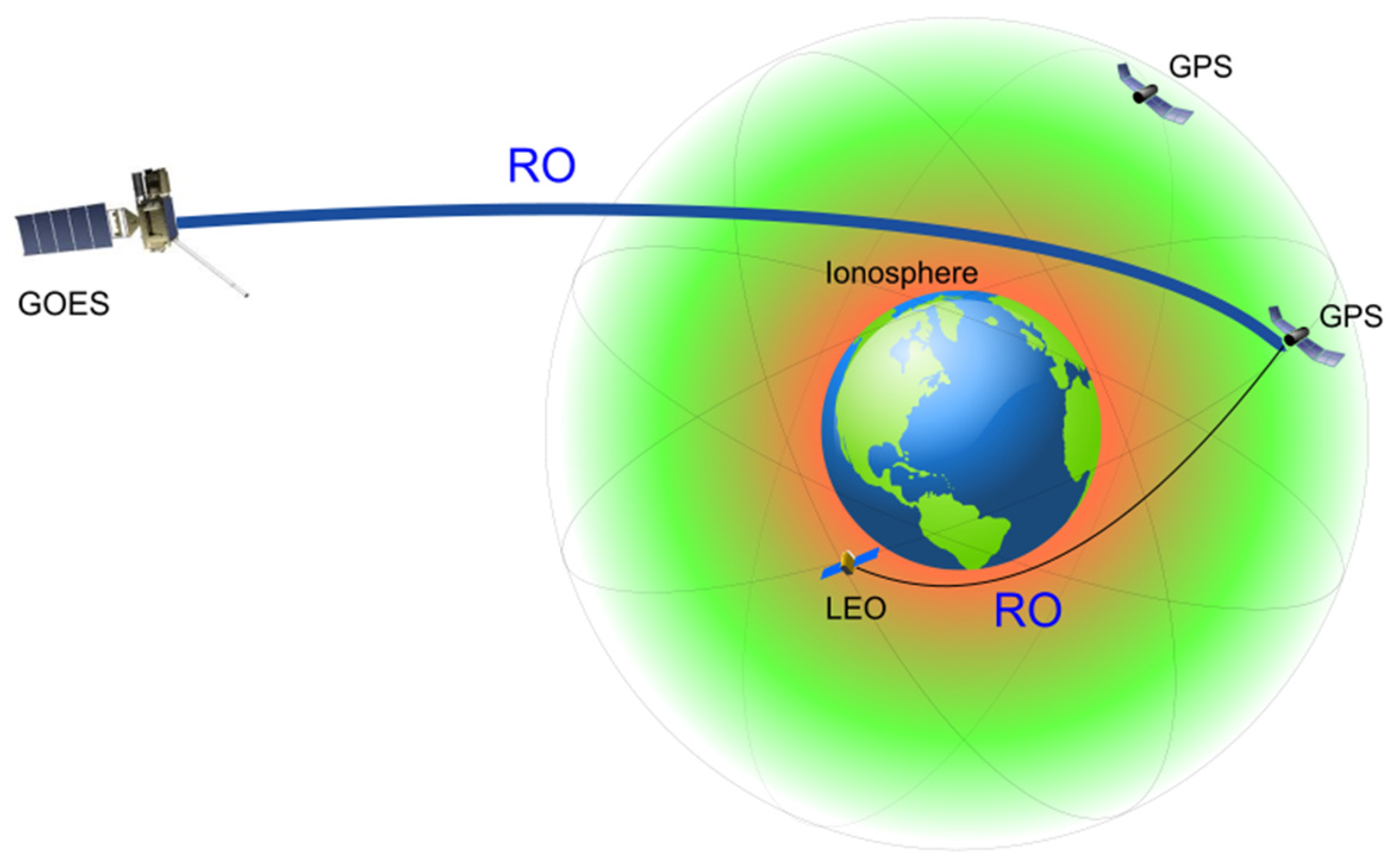
Figure 1. The sketch view of the GOES–GPS and LEO–GPS radio occultation experiment configurations.
Atmosphere 15 01065 g001
Figure 2. Variations in IMF Bz and auroral electrojet (AE) and SYM-H indices during 6–8 September 2017.
Atmosphere 15 01065 g002
Figure 3. The daily MLT-MLAT ROTI maps for the Northern Hemisphere for (ac) 6–8 September 2017. The maps cover 50–90° N MLAT with 10° latitude circles; the magnetic local noon/midnight is at the top/bottom and dusk/dawn. The blue color indicates no or very weak ionospheric irregularities, whereas the red color shows severe ionospheric irregularity occurrence.
Atmosphere 15 01065 g003
Figure 4. The rate of the TEC from the GOES GPS RO observations as a function of altitude (right) and ground-based ROTI maps corresponding to these occultation events (left) for (ad) several successful occultation events for pre-storm conditions on 7 September 2017. The gray shading on the maps shows the nighttime, and the thick black line shows the magnetic equator. The maps also show the position of GOES-16 at 72.5° W (large black dot), GOES RO tangent point projections (magenta dots), and line-of-sight link in the direction between the GEOS GPS receiver and GPS transmitter (black line).
Atmosphere 15 01065 g004
Figure 5. The same as Figure 4 but for the main phase of the storm on 8 September 2017 (ac).
Atmosphere 15 01065 g005
Figure 6. Variations in IMF Bz and auroral electrojet (AE) and SYM-H indices during 25–27 August 2018.
Atmosphere 15 01065 g006
Figure 7. The daily MLT-MLAT ROTI maps for the Northern Hemisphere for (ac) 25–27 August 2018. The maps cover 50–90° N MLAT with 10° latitude circles; the magnetic local noon/midnight is at the top/bottom and dusk/dawn.
Atmosphere 15 01065 g007
Figure 8. The rate of the TEC from the GOES GPS RO observations as a function of altitude (right) and the ground-based ROTI maps corresponding to these occultation events (left) for (a,b) several successful occultation events for the pre-storm conditions on 25 August 2018. The gray shading on the maps shows the nighttime, and the thick black line shows the magnetic equator. The maps also show the position of GOES-16 (large black dot), the GOES RO tangent point projections (magenta dots), and the line-of-sight link in the direction between the GEOS GPS receiver and GPS transmitter (black line).
Atmosphere 15 01065 g008
Figure 9. The same as Figure 8 but for (ac) several occultation events for the conditions after the storm onset on 25 August 2018.
Atmosphere 15 01065 g009
Figure 10. (ac) The same as Figure 8 but for 26 August 2018 (part 1).
Atmosphere 15 01065 g010
Figure 11. (ac) The same as Figure 8 but for 26 August 2018 (part 2).
Atmosphere 15 01065 g011
Disclaimer/Publisher’s Note: The statements, opinions and data contained in all publications are solely those of the individual author(s) and contributor(s) and not of MDPI and/or the editor(s). MDPI and/or the editor(s) disclaim responsibility for any injury to people or property resulting from any ideas, methods, instructions or products referred to in the content.