Article

Local Evapotranspiration Is the Only Relevant Source of Moisture at the Onset of the Rainy Season in South America

by
Verônica Versieux
and
Marcos Heil Costa
*
Department of Agricultural and Environmental Engineering, Federal University of Viçosa, Viçosa 36570-900, MG, Brazil
*
Author to whom correspondence should be addressed.
Atmosphere 2024, 15(8), 932; https://doi.org/10.3390/atmos15080932
Submission received: 27 June 2024 / Revised: 29 July 2024 / Accepted: 2 August 2024 / Published: 4 August 2024
(This article belongs to the Special Issue Land-Atmosphere Interactions)

Abstract

:
The South American Monsoon System, which transports moisture from Amazonia to Central-West Brazil, is an important moisture source for the summer rainy season in this region. While local evapotranspiration also contributes to the atmospheric moisture supply, the balance between local and remote sources during the onset of the rainy season remains uncertain. Our research aimed to quantify the role of local evapotranspiration in initiating the rainy season in Central-West Brazil. By utilizing data from various sources, such as remote sensing (MODIS), modern reanalysis (ECMWF’s ERA5), and composite products of rainfall (CHIRPS), and analyzing them in a comparative way, we conclusively found that local evapotranspiration is the only relevant source of moisture to the atmosphere during the dry-to-wet season transition, preceding the establishment of the monsoon system.

1. Introduction

The South American Monsoon System (SAMS), a large-scale circulation system that forms in response to seasonal changes in the thermal contrast between the continent and the Atlantic Ocean, is a key player in the region’s climate [1]. It is characterized by zonal wind reversal from east to west [2]. The region of influence of the South American Monsoon encompasses a significant portion of Northern and Central-West Brazil, as well as regions affected by other annual circulation mechanisms, such as the Intertropical Convergence Zone, and interannual phenomena, such as El Niño Southern Oscillation [3,4]. This region, with its unique features of the Amazon rainforest and a subtropical savanna, is particularly susceptible to minor climatic fluctuations. These fluctuations are influenced by various factors, including land use changes, sea surface temperatures, and evapotranspiration [5,6].
The prolongation of the dry season in this region, resulting from the delay of the rainy season onset, has been associated with the alteration of land use for the establishment of pastures and agricultural fields in recent years [5,6,7,8,9,10,11,12]. Some authors posit that the advent of the rainy season is linked to the establishment of the SAMS and the intensification of convective activity, which is influenced by sea surface temperatures over the Pacific and Atlantic oceans. This, in turn, leads to an increase in evapotranspiration in response to greater precipitation [2,13,14]. Other authors posit that it is associated with increased evapotranspiration during the transition season due to increased latent heat flux before the large-scale circulation change. They further suggest that increased precipitation initiates circulation change and convergence over the southern Amazon [3,15]. However, due to the complexity of this system, there is still no consensus regarding the role of evapotranspiration at the beginning of the rainy season, highlighting the need for further research in this area.
Evapotranspiration, a key player in the hydrological cycle and in ecosystem maintenance [11,16,17], requires precise estimation for effective monitoring. The prevalent methods for quantifying evapotranspiration are through satellites or ground observations. Ground observations are usually punctual and may not be representative of large regions. Satellites, despite their widespread coverage, often yield inaccurate values due to uncorrected estimation errors [18]. An alternative approach is reanalysis data, which uses various observational data in physical equations to simulate the atmosphere. This enables the generation of consistent data with high spatial and temporal resolution, facilitating more accurate historical analyses [19].
This study compares evapotranspiration data provided by the Moderate Resolution Imaging Spectroradiometer (MODIS) instrument on board two satellites and data from the ERA5 product based on observations and reanalysis. The comparison focuses on spatial differences between the two datasets. Additionally, a water balance calculation was conducted during the dry-to-wet season, utilizing precipitation and moisture convergence data in conjunction with the two evapotranspiration datasets. This comprehensive approach evaluates the interpretation of data from disparate sources and the importance of evapotranspiration as a source of moisture during the onset of the rainy season.

2. Materials and Methods

2.1. Study Area

The area of focus, the state of Mato Grosso, is a vast region located in the Central-West part of Brazil, covering an area of approximately 900,000 km2. Its boundaries span from about 7° S to 18° S latitude and 62° W to 52° W longitude (Figure 1A). The state is known for its unique transitional climate and vegetation—a mix of a tropical monsoon climate (Köppen’s Am) and the Amazon rainforest in the northwest and a tropical climate with a winter dry season (Köppen’s Aw) and a subtropical savanna and large-scale agricultural land use in the southeast (Figure 1B). The distinct wet and dry seasons are significantly influenced by the South American monsoon during the wet season [2], a climatic phenomenon where a reversal of zonal wind fields characterizes the transition between seasons from August to early October (Figure 1C–H).
These two notable climates characterize the rainfall regime in two distinct seasons, with a remarkable spatial gradient occurring from north to south [20]. Precipitation is distributed over a period of six to eight months, and the remainder of the year is characterized by a dry season. The average annual precipitation in the Amazon region exceeds 2000 mm, while the subtropical savanna region receives approximately 1000 mm of precipitation annually [21]. The prolonged duration of the rainy season is a critical component of the double-cropping agricultural system that exists in the state.

2.2. Rainfall Data

This study utilizes daily precipitation data developed by Climate Hazards Group InfraRed Precipitation (CHIRPS) in collaboration with the USGS Earth Resources Observation and Science (EROS). CHIRPS version 2.0 integrates information from satellite-based precipitation estimates derived from NASA and NOAA satellites, as well as ground stations spanning a latitudinal range of 50° S to 50° N. The product offers daily and monthly rainfall maps, particularly in regions with scarce surface data. The spatial resolution of this dataset is 0.25° × 0.25°, covering the period from 1981 to the present [22]. It is possible to download this dataset from the Climate Hazards Group’s official website [23].
The product was selected based on its favorable performance in seasonal drought and its resemblance to rain gauge stations in the region with respect to monthly and annual trends [24,25]. As a global product with high spatial and temporal resolution, the dataset has proven to be a valuable resource in studies of precipitation patterns worldwide [26,27,28]. For research purposes and environmental management, the quality, accessibility, and low latency of the dataset make it an invaluable tool for environmental decisions.
Other products were considered but were excluded due to their inherent limitations. For instance, the rainfall ERA5 product was rejected due to its dependence on atmospheric modeling and its status as a climate reanalysis. Similarly, the Brazilian Daily Weather Gridded from Xavier was excluded due to its geographic boundaries, which are specific to Brazil, and the incorporation of only observation data from rain gauges and weather stations [29], which hinders precision in areas with a low density of such infrastructure. Additionally, other satellite-based products, such as the Tropical Rainfall Measuring Mission (TRMM), are incorporated in CHIRPS for calibration purposes and exhibit a similar performance [30].

2.3. Moisture Convergence Data

The moisture convergence data represents the opposite (negative) of the variable “Vertical integral of the divergence of moisture flux”. This variable is part of the fifth-generation Atmospheric Reanalysis dataset ERA5, provided by the European Center for Medium-Range Weather Forecast (ECMWF). ERA5 combines model-generated data based on physical laws with global observations, resulting in an optimal forecast that improves product quality through available observations [31].
Moisture convergence represents the moisture rate concentrating in a vertical column of the atmosphere. The spatial resolution for moisture convergence is 0.25° × 0.25°, and hourly temporal data are available from 1940 onwards and can be downloaded from Climate Copernicus [31].

2.4. Evapotranspiration Data

For evapotranspiration, we considered data from two distinct sources. First, the variable “Evaporation” from the ERA5 dataset represents the accumulated amount of evaporated water from the Earth’s surface and vegetation transpiration. ERA5 relies on a parametric model that incorporates process-based models.
Second, the product “Total Evapotranspiration” is provided by NASA (MYD16A2GF version 6.1). This dataset is based on images captured by the Moderate Resolution Imaging Spectroradiometer (MODIS) aboard the Terra and Aqua satellites [32]. It can be downloaded from EARTHDATA [33]. It has a native spatial resolution of 500 m × 500 m and provides 8-day composite images from 2001 to 2022. The final product is derived from the Penman–Monteith equation, which combines daily meteorological reanalysis data with remotely sensed information (e.g., vegetation greenness, albedo, and land cover) to enhance the algorithm.
The rationale behind utilizing both variables lies in the difference in their production methods and their implications for analysis. While the ERA5 product is fully consistent with the reanalysis, it has the disadvantage of being entirely model-generated and may have inherent biases. On the other hand, the MYD16 data, based on remote sensing observations, includes actual evaluations of vegetation status.

2.5. Analysis

Given our focus on analyzing the onset of the rainy season, we adopted the hydrological year concept starting on 1 July. This period covers the transition from dry to wet conditions from July to October [34]. To facilitate analysis, enhance data robustness, and avoid interference from smaller-scale phenomena, we standardized the spatial resolution to 0.5° × 0.5° and aligned the temporal resolution to fortnights. The first fortnight spans from day 1 to day 15, while the second fortnight covers day 16 to day 30 (September) or 31 (July, August, October). All data were converted to mm.day−1.
The main analysis is based on the vertical water balance equation during the period (Equation (1)), computing the water inputs (C+ET) and outputs (P) to and from the atmospheric column to investigate the role of evapotranspiration on the onset of rain. The water balance was calculated as follows, assuming that the change in precipitable water is negligible over 15 days:
P = C + ET,
where P is precipitation, C is moisture convergence, and ET is evapotranspiration. Finally, the ratio ET/P was calculated to assess the importance of ET as an input of water vapor to the atmosphere at the onset of rainfall.
To identify the different behavior of evapotranspiration from MODIS and ERA5 during the dry-to-wet transition, the products were compared in terms of their spatial variability over each fortnight. All calculations were conducted for both products to ascertain the discrepancy between MODIS and ERA5 evaporation.

3. Results

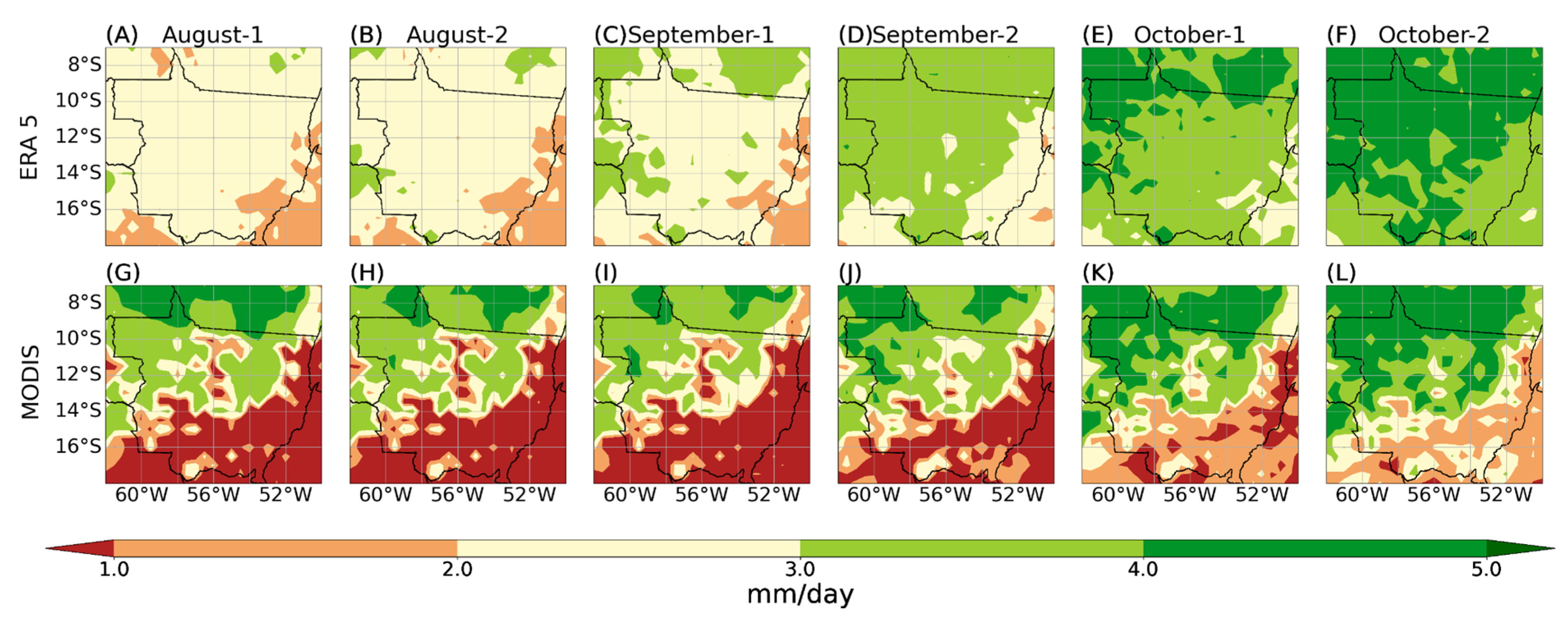
A distinct contrast emerges between the ERA5 parametric dataset and the MODIS algorithm, particularly concerning the spatial distribution of evapotranspiration (Figure 2). While some similarities exist—such as the abrupt increase in ET from 1 October onward, especially in ERA5—significant differences prevail. ERA5 simulates lower ET levels in the Amazon Forest region from August-1 to September-1. Notably, the ERA5 data’s reliance on their land cover dataset becomes evident on September-1 ET (compare Figure 2C with Figure 1B). By contrast, the MYD16 product, based on actual observations, does not exhibit the same dependence. During October, both datasets show similar ET levels.
Conversely, in the tropical savanna climate region, ERA5 overestimates ET compared to MODIS during the dry, transition, and rainy seasons. Our working hypothesis posits moisture transport from the northern to the southern part of the state. Consequently, our primary concern lies in understanding the ET differences in the northern region.
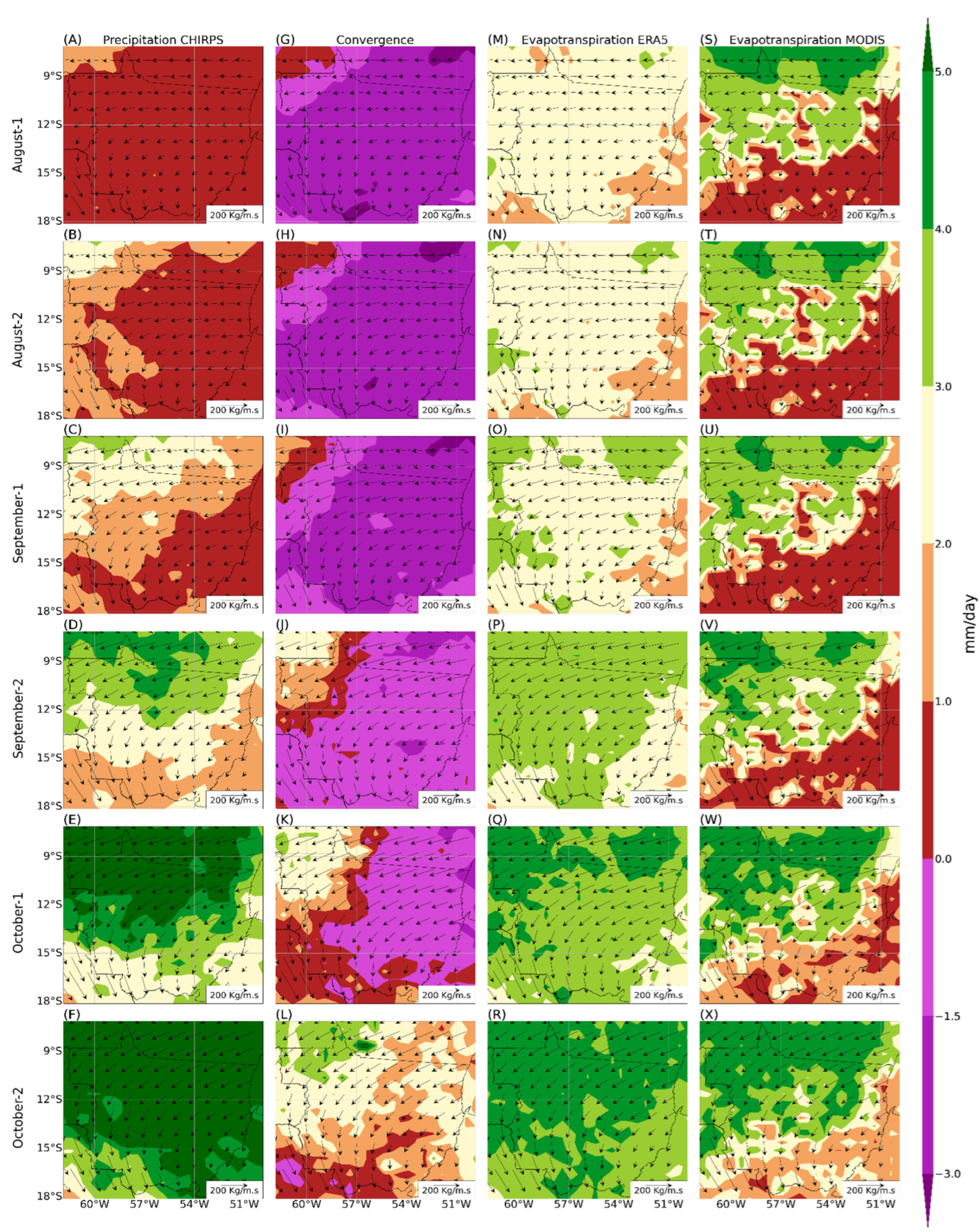
Figure 3A–F delineate the onset of the rainy season. Typically, this season is characterized by cumulative rainfall over short periods, surpassing a threshold ranging from 2.5 mm/day [21] to 3.3 mm/day [35]. Applying these criteria, the rainy season starts in the northwest part of the state during early to mid-September, gradually advancing southeastward through the month. By late October, it envelops the entire state.
In Figure 3G–L, we observe widespread water vapor divergence across most of the state during August and September. However, even after rains have initiated in most areas by October-1, approximately half of the state still exhibits moisture divergence. Moisture convergence begins in the northwestern region during early September, progressively shifting southeastward throughout September and October. Notably, moisture convergence becomes dominant only in late October.
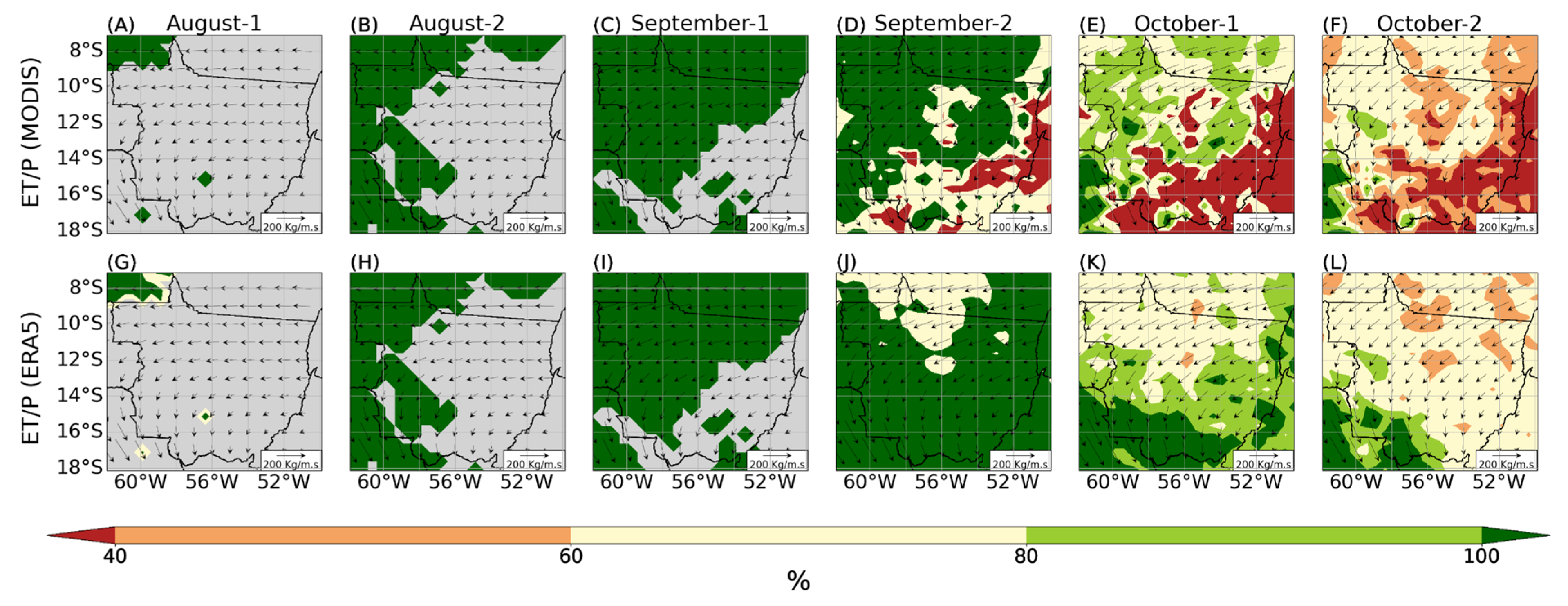
Until that point, the primary moisture input to the atmosphere stems from local evaporation (Figure 3M–X). Interestingly, the MODIS data (Figure 4A–F) indicates higher local evaporation than the ERA5 data (Figure 4G–L). Analyzing the vertical water balance (Figure 4), we find that the transition from the dry to wet season is initiated by local evaporation, evident around August-2 and September-1. During this period, the reversal of zonal wind patterns begins. Despite relevant rainfall in the northwest of Mato Grosso, convergence remains low and smaller than precipitation in the same area (as depicted in Figure 3). By September-2, while the entire state experiences significant rainfall, moisture divergence still prevails, with convergence only beginning in the northwest.
In the ET/P ratio analyses, based on both MODIS and ERA5 ET data (Figure 4A–L), a striking difference emerges in the state’s homogeneity. The MODIS data distinctly delineate between rainforest and tropical savanna regions. By contrast, the ERA5 dataset lacks this distinction, likely due to the parametrization of the ERA5 land model. Despite value discrepancies, the results clearly highlight that local evapotranspiration is the only relevant source of water vapor input into the atmosphere during September and October, particularly at the onset of the rainy season. Specifically, the ET/P ratio exceeds 100 percent across most of the state during these months (as shown in Figure 4).
Quantitatively, as the rainy season begins, convergence approaches zero or becomes negative, while evapotranspiration surpasses precipitation. Consequently, evapotranspiration accounts for 100 percent of the atmospheric moisture supply, driven solely by local evaporation.
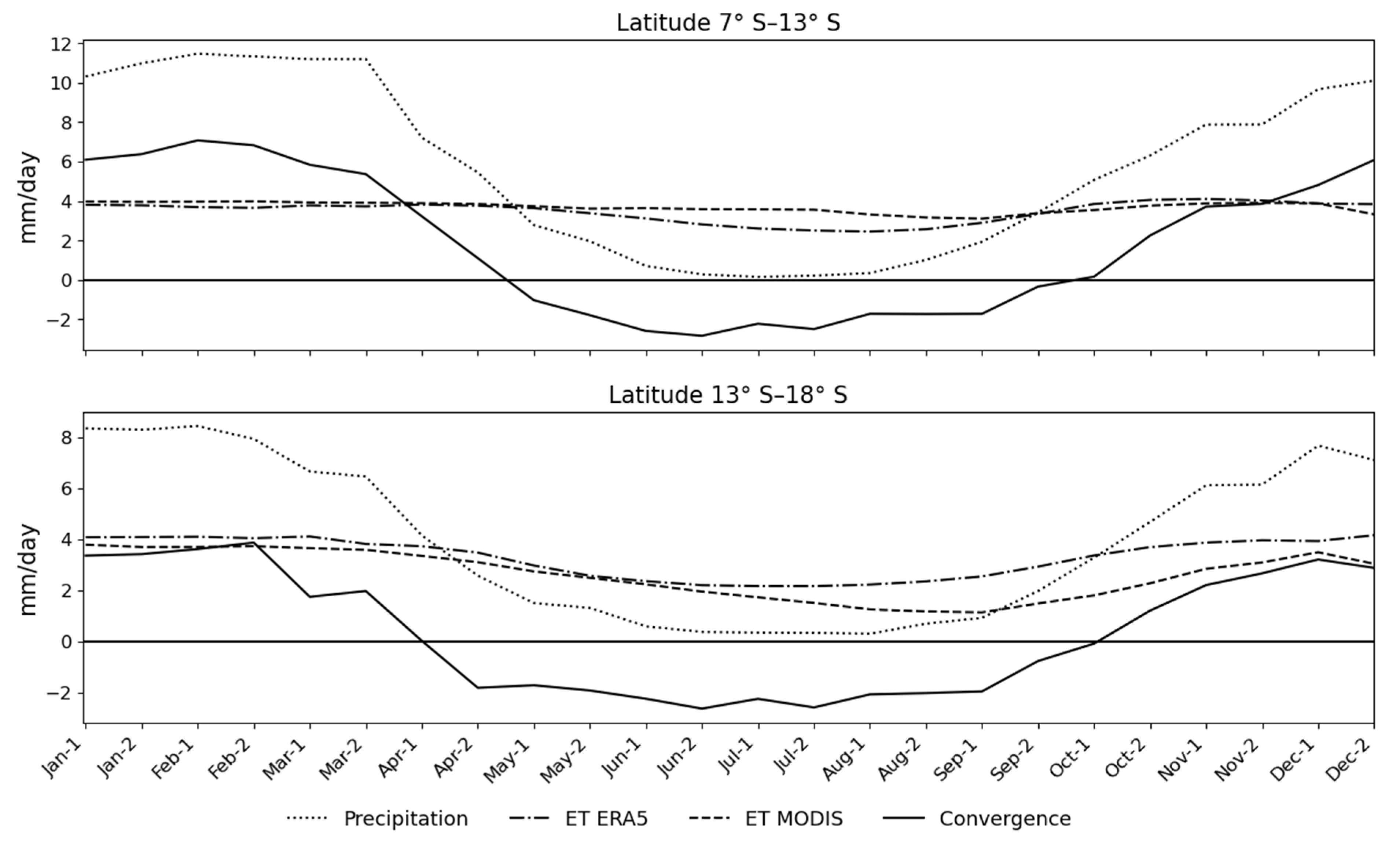
In the time series analysis (Figure 5), we observe the annual behavior of all variables, separated by two different regions. Positive (negative) values represent convergence (divergence). Between 7° S and 13° S, the precipitation begins to increase on August-2, even when strong water vapor divergences occur. Between August-2 and September-2, ET is the main source of water vapor into the atmosphere. Between 13° S and 18° S, the behavior is similar, but the precipitation starts to increase on Sep-1, and throughout the month of September, ET is the main source of water vapor into the atmosphere.
Between 7° S and 13° S, both evapotranspiration products, ERA5 and MODIS, had similar behavior, with a small difference during the month of July. Between 13° S and 18° S, the ERA5 evapotranspiration had higher values during the dry-to-wet and rainy season. The ET also had an important role in the ending of the rainy season when the convection was over between Apr-1 and May-1, and precipitation remained until the beginning of June.

4. Discussion

A comparative analysis of evapotranspiration accuracy across different models—reanalysis, satellites, and land surface datasets—over East Asia reveals intriguing spatio-temporal patterns. Specifically, the MODIS dataset tends to overestimate values under moderate-to-heavy cloud cover and underestimate them under conditions of minimal cloud cover [18]. The uncertainty in MODIS evapotranspiration estimates can be attributed to the input land cover data used in the Penman–Monteith equation. This discrepancy may result from an overestimation in densely vegetated regions or algorithmic limitations that hinder the accounting of all relevant biophysical parameters [36].
Applying these findings to our study region sheds light on pronounced differences between rainforests—characterized by dense vegetation and extended cloud cover periods—and subtropical savannas, which experience smaller cloud cover [18].
By contrast, the ERA5 model consistently estimates evapotranspiration under minimal cloud cover but tends to overestimate it under moderate-to-heavy cloud cover [18]. Interestingly, our own observations (depicted in Figure 2A–F and Figure 5) anticipated overestimation in subtropical savannas and underestimation in rainforests. This discrepancy likely arises from other influencing factors. Notably, the ERA5 model contains a bug that underestimates potential evaporation over deserts and densely forested areas [37]. Further analysis reveals that the ERA5 reanalysis does not adequately account for intensive land use changes, and a recent, dynamic land use map is still in development [19]. The dataset used relies on the Global Land Cover Characteristics (GLCC) version 1.2 as the land cover data base [38]. Although both ERA5 and MODIS datasets exhibit identified uncertainty, the ERA5 land cover dataset appears to be the main source of discrepancies between the different land cover types.
The identified uncertainties in both ERA5 and MODIS datasets do not alter the main result; from August-2 to September-1, local evapotranspiration is the only relevant source of moisture to precipitation. From September-2 onward, outside sources of moisture gradually gain relevance, but the local sources still dominate in most of the state until October-2. In southern Mato Grosso, evapotranspiration is higher than moisture convergence throughout the entire year (Figure 5).
Despite the difference between the reanalysis and remote sensing ET data, the comprehensive nature of ERA5 data—coupled with its high spatial and temporal resolution—renders it invaluable for studying climate trends in the Mato Grosso region. However, it is crucial to recognize that an outdated land use map could significantly impact result accuracy. Numerous studies have demonstrated a link between deforestation, reduced rainfall, and delayed rainy seasons across various scenarios. Extensive deforestation, in particular, can lead to significant delays in the onset of the rainy season [3,7,8,12,16,39,40,41,42]. Therefore, any land use alterations in this region—especially one sensitive to surface atmosphere interactions—must be carefully considered during data processing to enhance result reliability.
The findings of this study underscore the critical role of rainfed agriculture in Mato Grosso, where local evapotranspiration significantly influences the onset of the rainy season. Evapotranspiration, by supplying moisture to the atmosphere prior to deep convection (as depicted in Figure 2, Figure 3G–L and Figure 5), reinforces the hypothesis that superficial convection—activated through local evapotranspiration—preconditions the atmosphere for deeper convective processes [3]. Across both datasets, increased evapotranspiration contributes to advancing the rainy season, with tropical forests serving as the primary source.
While ERA5 data (Figure 3M–R) pose challenges due to parametrization, the MODIS data (Figure 3S–X, compared with Figure 1B) clearly reveal distinctions. Areas lacking rainforests exhibit lower evapotranspiration values (Figure 5), suggesting that onset delays result from local evapotranspiration reduction rather than large-scale circulation changes.
In Mato Grosso, over the long term, >40% of the precipitation originates from continental evaporation, with the Amazon region contributing significantly—where more than 70% of evaporation returns to the continent as rainfall [42]. Rainfed agriculture relies on a consistent rainy season length for high productivity. Even minor reductions could significantly impact crop yields and food security [10,43]. The conversion of forestland to pasture and agricultural fields reduces available moisture, affecting local evapotranspiration.
However, accurately representing meteorological conditions in regions like the Amazon remains challenging due to scarce in situ meteorological data. The ongoing land use changes further complicate matters, and despite constant updates to other variables, an outdated land use map can influence results. Integrating new observational data—such as sophisticated sensors and regularly updated land use and vegetation cover information—can enhance surface atmosphere interaction analysis and reduce associated uncertainties.
As the Terra and Aqua MODIS platforms are near their end of life, maintaining these costly platforms becomes challenging. Developing alternative sensors and instruments with global spatial resolution and easy accessibility remains a priority, as well as ready-to-use global evapotranspiration products. Notably, the U.S. Department of Agriculture’s Agricultural Research Service has developed the Atmosphere-Land Exchange Inverse Model (ALEXI) to calculate the Global Daily Evapotranspiration (GloDET) dataset. ALEXI utilizes radiometric temperature data from the VIIRS sensor onboard polar orbit satellites, with a spatial resolution of 375 m [44]. While accessing these data in real-time poses difficulties compared to MODIS, VIIRS Collection 2 shows promise as a potential MODIS substitute [45].
Acknowledging the limitations of this study, which represents a mean of twenty years, it is essential to recognize that interannual variability—often influential in evapotranspiration dynamics—is not fully captured. To address this, we must consider external factors, such as sea surface anomalies in the tropical Atlantic and Pacific (as highlighted by [41]) and changes in atmospheric circulation associated with El Niño and La Niña events (as discussed by [3]). These natural climate variations can lead to prolonged dry seasons and shorter rainy periods, thereby exacerbating regional vulnerability to fire risks [6]. Investigating local evapotranspiration behavior under these conditions becomes crucial for a deeper understanding of the underlying mechanisms.
Given the pivotal role of local evapotranspiration in initiating the rainy season, it is imperative to quantify the necessary atmospheric moisture input required to avert rainfall delays. Some studies suggest that irrigated agriculture might mitigate the impact of deforestation on rainfall patterns [11]. However, implementing such a system across the entire state remains a formidable challenge.

5. Conclusions

The main conclusion is that local evapotranspiration plays a pivotal role at the onset of the rainy season, preceding the establishment of the South American monsoon. As the rainy season begins, evapotranspiration accounts for 100 percent of the atmospheric moisture supply, while parts of moisture supplied by local evapotranspiration diverge to other regions.
This study also highlights significant discrepancies in evapotranspiration estimates across different models. Specifically, the MODIS dataset tends to overestimate evapotranspiration under moderate-to-heavy cloud cover and underestimate it under small cloud cover. Conversely, the ERA5 model shows consistent results under minimal cloud cover but overestimates it under heavier cloud conditions. These inconsistencies can be attributed to limitations in the algorithms and outdated land cover data used in the ERA5 model. The findings underscore the critical importance of precise land use data, especially in regions like Mato Grosso, which have experienced substantial land cover changes in recent years.
This highlights the urgent need for updated observational data and improved models. While transitioning from MODIS to a more contemporary version of VIIRS data is promising, a deeper understanding of the intricate interplay between land use alterations and atmospheric phenomena remains essential for refining evapotranspiration estimations and mitigating the consequences of deforestation on local and regional climates.

Author Contributions

Conceptualization, V.V. and M.H.C.; methodology, V.V. and M.H.C.; software, V.V.; validation, M.H.C. and V.V.; formal analysis, V.V.; investigation, M.H.C.; resources, M.H.C.; data curation, V.V.; writing—original draft preparation, V.V.; writing—review and editing, M.H.C.; visualization, V.V.; supervision, M.H.C.; project administration, M.H.C.; funding acquisition, M.H.C. All authors have read and agreed to the published version of the manuscript.

Funding

This study was financed by the Coordenação de Aperfeiçoamento de Pessoal de Nível Superior—Brasil (CAPES)—Finance Code 001.

Institutional Review Board Statement

Not applicable.

Informed Consent Statement

Not applicable.

Data Availability Statement

The ERA5 reanalysis data presented in this study are openly available in Copernicus Climate Data Store at DOI: 10.24381/cds.adbb2d47. The MODIS data presented in this study were obtained from the NASA EOSDIS Land Processes Distributed Active Archive Center at DOI: 10.5067/MODIS/MYD16A2GF.061. The CHIRPS data presented in this study provided by the Climate Hazards Group at the University of California, Santa Barbara are openly available at https://www.chc.ucsb.edu/data/chirps (accessed on 1 August 2023).

Conflicts of Interest

The authors declare no conflict of interest.

References

  1. Vera, C.; Higgins, W.; Amador, J.; Ambrizzi, T.; Garreaud, R.; Gochis, D.; Gutzler, D.; Lettenmaier, D.; Marengo, J.; Mechoso, C.R.; et al. Toward a Unified View of the American Monsoon Systems. J. Clim. 2006, 19, 4977–5000. [Google Scholar] [CrossRef]
  2. Gan, M.A.; Kousky, V.E.; Ropelewski, C.F. The South America Monsoon Circulation and Its Relationship to Rainfall over West-Central Brazil. J. Clim. 2004, 17, 47–66. [Google Scholar] [CrossRef]
  3. Wright, J.S.; Fu, R.; Worden, J.R.; Chakraborty, S.; Clinton, N.E.; Risi, C.; Sun, Y.; Yin, L. Rainforest-Initiated Wet Season Onset over the Southern Amazon. Proc. Natl. Acad. Sci. USA 2017, 114, 8481–8486. [Google Scholar] [CrossRef] [PubMed]
  4. Espinoza, J.-C.; Marengo, J.A.; Schongart, J.; Jimenez, J.C. The New Historical Flood of 2021 in the Amazon River Compared to Major Floods of the 21st Century: Atmospheric Features in the Context of the Intensification of Floods. Weather Clim. Extrem. 2022, 35, 100406. [Google Scholar] [CrossRef]
  5. Costa, M.H.; Foley, J.A. Combined Effects of Deforestation and Doubled Atmospheric CO 2 Concentrations on the Climate of Amazonia. J. Clim. 2000, 13, 18–34. [Google Scholar] [CrossRef]
  6. Marengo, J.A.; Souza, C.M.; Thonicke, K.; Burton, C.; Halladay, K.; Betts, R.A.; Alves, L.M.; Soares, W.R. Changes in Climate and Land Use Over the Amazon Region: Current and Future Variability and Trends. Front. Earth Sci. 2018, 6, 228. [Google Scholar] [CrossRef]
  7. Leite-Filho, A.T.; Soares-Filho, B.S.; Davis, J.L.; Abrahão, G.M.; Börner, J. Deforestation Reduces Rainfall and Agricultural Revenues in the Brazilian Amazon. Nat. Commun. 2021, 12, 2591. [Google Scholar] [CrossRef] [PubMed]
  8. Leite-Filho, A.T.; Costa, M.H.; Fu, R. The Southern Amazon Rainy Season: The Role of Deforestation and Its Interactions with Large-scale Mechanisms. Int. J. Climatol. 2020, 40, 2328–2341. [Google Scholar] [CrossRef]
  9. Staal, A.; Flores, B.M.; Aguiar, A.P.D.; Bosmans, J.H.C.; Fetzer, I.; Tuinenburg, O.A. Feedback between Drought and Deforestation in the Amazon. Environ. Res. Lett. 2020, 15, 044024. [Google Scholar] [CrossRef]
  10. Pires, G.F.; Abrahão, G.M.; Brumatti, L.M.; Oliveira, L.J.C.; Costa, M.H.; Liddicoat, S.; Kato, E.; Ladle, R.J. Increased Climate Risk in Brazilian Double Cropping Agriculture Systems: Implications for Land Use in Northern Brazil. Agric. For. Meteorol. 2016, 228–229, 286–298. [Google Scholar] [CrossRef]
  11. Bagley, J.E.; Desai, A.R.; Dirmeyer, P.A.; Foley, J.A. Effects of Land Cover Change on Moisture Availability and Potential Crop Yield in the World’s Breadbaskets. Environ. Res. Lett. 2012, 7, 014009. [Google Scholar] [CrossRef]
  12. Sampaio, G.; Nobre, C.; Costa, M.H.; Satyamurty, P.; Soares-Filho, B.S.; Cardoso, M. Regional Climate Change over Eastern Amazonia Caused by Pasture and Soybean Cropland Expansion. Geophys. Res. Lett. 2007, 34, 17. [Google Scholar] [CrossRef]
  13. Correa, I.C.; Arias, P.A.; Rojas, M. Evaluation of Multiple Indices of the South American Monsoon. Int. J. Climatol. 2021, 41 (Suppl. S1), E2801–E2819. [Google Scholar] [CrossRef]
  14. Nobre, C.A.; Obregón, G.O.; Marengo, J.A.; Fu, R.; Poveda, G. Characteristics of Amazonian Climate: Main Features. In Amazonia and Global Change; American Geophysical Union: Washington, DC, USA, 2009; pp. 149–162. [Google Scholar]
  15. Fu, R.; Li, W. The Influence of the Land Surface on the Transition from Dry to Wet Season in Amazonia. Theor. Appl. Climatol. 2004, 78, 97–110. [Google Scholar] [CrossRef]
  16. Costa, M.H.; Fleck, L.C.; Cohn, A.S.; Abrahão, G.M.; Brando, P.M.; Coe, M.T.; Fu, R.; Lawrence, D.; Pires, G.F.; Pousa, R.; et al. Climate Risks to Amazon Agriculture Suggest a Rationale to Conserve Local Ecosystems. Front. Ecol. Environ. 2019, 17, 584–590. [Google Scholar] [CrossRef]
  17. Keys, P.W.; Porkka, M.; Wang-Erlandsson, L.; Fetzer, I.; Gleeson, T.; Gordon, L.J. Invisible Water Security: Moisture Recycling and Water Resilience. Water Secur. 2019, 8, 100046. [Google Scholar] [CrossRef]
  18. Wang, Y.; Hu, J.; Li, R.; Song, B.; Hailemariam, M.; Fu, Y.; Duan, J. Increasing Cloud Coverage Deteriorates Evapotranspiration Estimating Accuracy From Satellite, Reanalysis and Land Surface Models Over East Asia. Geophys. Res. Lett. 2023, 50, e2022GL102706. [Google Scholar] [CrossRef]
  19. da Silva, Q.P.; Moreira, D.S.; de Freitas, H.C.; Domingues, L.M. Discrepancies between Observation and ERA5 Reanalysis in the Amazon Deforestation Context: A Case Study. Dyn. Atmos. Ocean. 2024, 106, 101442. [Google Scholar] [CrossRef]
  20. Dubreuil, V.; Jallet, A.; Ronchail, J.; Maitelli, G. Estimation des précipitations par télédétection au Mato Grosso (Brésil). Ann. L’association Int. Climatol. 2004, 1, 133–156. [Google Scholar] [CrossRef]
  21. Arvor, D.; Dubreuil, V.; Ronchail, J.; Simões, M.; Funatsu, B.M. Spatial patterns of rainfall regimes related to levels of double cropping agriculture systems in Mato Grosso (Brazil). Int. J. Climatol. 2014, 34, 2622–2633. [Google Scholar] [CrossRef]
  22. Funk, C.; Peterson, P.; Landsfeld, M.; Pedreros, D.; Verdin, J.; Shukla, S.; Husak, G.; Rowland, J.; Harrison, L.; Hoell, A.; et al. The Climate Hazards Infrared Precipitation with Stations—A New Environmental Record for Monitoring Extremes. Sci. Data 2015, 2, 1–21. [Google Scholar] [CrossRef]
  23. CHIRPS-2.0. Available online: https://data.chc.ucsb.edu/products/CHIRPS-2.0/ (accessed on 1 August 2023).
  24. Cavalcante, R.B.L.; Ferreira, D.B.dS.; Pontes, P.R.M.; Tedeschi, R.G.; da Costa, C.P.W.; de Souza, E.B. Evaluation of extreme rainfall indices from CHIRPS precipitation estimates over the Brazilian Amazonia. Atmos. Res. 2020, 238, 104879. [Google Scholar] [CrossRef]
  25. Paredes-Trejo, F.; Alves Barbosa, H.; Venkata Lakshmi Kumar, T.; Kumar Thakur, M.; de Oliveira Buriti, C. Assessment of the CHIRPS-Based Satellite Precipitation Estimates. In Inland Waters—Dynamics and Ecology; IntechOpen: London, UK, 2021. [Google Scholar] [CrossRef]
  26. Chervenkov, H.; Slavov, K. Applicability of the CHIRPS Precipitation Product in the Regional Climatology of Southeast Europe. In Recent Advances in Computational Optimization; Springer: Cham, Switzerland, 2024; pp. 18–29. [Google Scholar] [CrossRef]
  27. Dinku, T.; Funk, C.; Peterson, P.; Maidment, R.; Tadesse, T.; Gadain, H.; Ceccato, P. Validation of the CHIRPS satellite rainfall estimates over eastern Africa. Q. J. R. Meteorol. Soc. 2018, 144 (Suppl. S1), 292–312. [Google Scholar] [CrossRef]
  28. Duan, Z.; Liu, J.; Tuo, Y.; Chiogna, G.; Disse, M. Evaluation of eight high spatial resolution gridded precipitation products in Adige Basin (Italy) at multiple temporal and spatial scales. Sci. Total Environ. 2016, 573, 1536–1553. [Google Scholar] [CrossRef] [PubMed]
  29. Xavier, A.C.; Scanlon, B.R.; King, C.W.; Alves, A.I. New improved Brazilian daily weather gridded data (1961–2020). Int. J. Climatol. 2022, 42, 8390–8404. [Google Scholar] [CrossRef]
  30. de Andrade, J.M.; Ribeiro Neto, A.; Bezerra, U.A.; Moraes, A.C.C.; Montenegro, S.M.G.L. A comprehensive assessment of precipitation products: Temporal and spatial analyses over terrestrial biomes in Northeastern Brazil. Remote Sens. Appl. Soc. Environ. 2022, 28, 100842. [Google Scholar] [CrossRef]
  31. Hersbach, H.; Bell, B.; Berrisford, P.; Biavati, G.; Horányi, A.; Muñoz Sabater, J.; Nicolas, J.; Peubey, C.; Radu, R.; Rozum, I.; et al. ERA5 Hourly Data on Single Levels from 1940 to Present. Copernicus Clim. Chang. Serv. Clim. Data Store 2023. [Google Scholar] [CrossRef]
  32. Running, S.; Mu, Q.; Zhao, M.; Moreno, A. MODIS/Aqua Net Evapotranspiration Gap-Filled 8-Day L4 Global 500m SIN Grid V061 [Data Set]; NASA EOSDIS Land Processes Distributed Active Archive Center: Sioux Falls, FD, USA, 2021. [Google Scholar] [CrossRef]
  33. EARTHDATA. Available online: https://search.earthdata.nasa.gov/search (accessed on 1 August 2023).
  34. Espinoza, J.-C.; Arias, P.A.; Moron, V.; Junquas, C.; Segura, H.; Sierra-Pérez, J.P.; Wongchuig, S.; Condom, T. Recent Changes in the Atmospheric Circulation Patterns during the Dry-to-Wet Transition Season in South Tropical South America (1979–2020): Impacts on Precipitation and Fire Season. J. Clim. 2021, 34, 9025–9042. [Google Scholar] [CrossRef]
  35. Sombroek, W. Spatial and Temporal Patterns of Amazon Rainfall. AMBIO A J. Hum. Environ. 2001, 30, 388–396. [Google Scholar] [CrossRef]
  36. Mu, Q.; Zhao, M.; Running, S.W. MODIS Global Terrestrial Evapotranspiration (ET) Product (NASA MOD16A2/A3) Algorithm Theoretical Basis Document Collection 5; NASA: Washington, DC, USA, 2013. [Google Scholar]
  37. ERA5 Data Documentation: Known Issues. Available online: https://confluence.ecmwf.int/display/CKB/ERA5%3A+data+documentation#ERA5:datadocumentation-Knownissues (accessed on 1 April 2024).
  38. ECMWF. IFS Documentation CY41R2—Part IV: Physical Processes. In IFS Documentation CY41R2; ECMWF: Reading, UK, 2016. [Google Scholar] [CrossRef]
  39. Commar, L.F.S.; Abrahão, G.M.; Costa, M.H. A Possible Deforestation-Induced Synoptic-Scale Circulation That Delays the Rainy Season Onset in Amazonia. Environ. Res. Lett. 2023, 18, 044041. [Google Scholar] [CrossRef]
  40. Fu, R.; Yin, L.; Li, W.; Arias, P.A.; Dickinson, R.E.; Huang, L.; Chakraborty, S.; Fernandes, K.; Liebmann, B.; Fisher, R.; et al. Increased Dry-Season Length over Southern Amazonia in Recent Decades and Its Implication for Future Climate Projection. Proc. Natl. Acad. Sci. USA 2013, 110, 18110–18115. [Google Scholar] [CrossRef] [PubMed]
  41. Marengo, J.A.; Ambrizzi, T.; da Rocha, R.P.; Alves, L.M.; Cuadra, S.V.; Valverde, M.C.; Torres, R.R.; Santos, D.C.; Ferraz, S.E.T. Future Change of Climate in South America in the Late Twenty-First Century: Intercomparison of Scenarios from Three Regional Climate Models. Clim. Dyn. 2010, 35, 1073–1097. [Google Scholar] [CrossRef]
  42. Van Der Ent, R.J.; Savenije, H.H.G.; Schaefli, B.; Steele-Dunne, S.C. Origin and Fate of Atmospheric Moisture over Continents. Water Resour. Res. 2010, 46, 9. [Google Scholar] [CrossRef]
  43. Rockström, J.; Falkenmark, M.; Karlberg, L.; Hoff, H.; Rost, S.; Gerten, D. Future Water Availability for Global Food Production: The Potential of Green Water for Increasing Resilience to Global Change. Water Resour. Res. 2009, 45, 7. [Google Scholar] [CrossRef]
  44. Anderson, M.C.; Norman, J.M.; Mecikalski, J.R.; Otkin, J.A.; Kustas, W.P. A Climatological Study of Evapotranspiration and Moisture Stress across the Continental United States Based on Thermal Remote Sensing: 1. Model Formulation. J. Geophys. Res. Atmos. 2007, 112, D10. [Google Scholar] [CrossRef]
  45. Román, M.O.; Justice, C.; Paynter, I.; Boucher, P.B.; Devadiga, S.; Endsley, A.; Erb, A.; Friedl, M.; Gao, H.; Giglio, L.; et al. Continuity between NASA MODIS Collection 6.1 and VIIRS Collection 2 Land Products. Remote Sens. Environ. 2024, 302, 113963. [Google Scholar] [CrossRef]
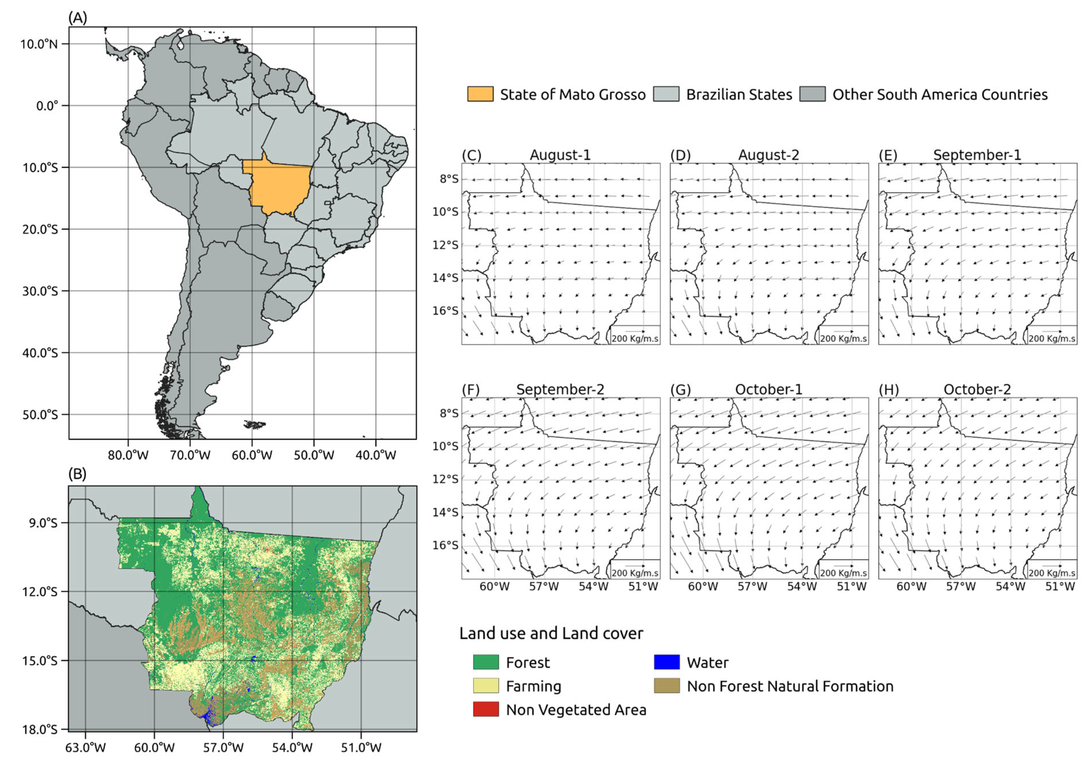
Figure 1. Orientation map (A); representation of land use and land cover in the study area (B) and the mean moisture flux direction in the six fortnights before and after the climatological onset of the rainy season in Mato Grosso (CH), showing the gradual shift in patterns, from a westward direction to a southeastward direction, which characterizes the beginning of the South American monsoon.
Atmosphere 15 00932 g001
Figure 2. Comparison of evaporation data from MODIS (GL) and ERA5 (AF).
Atmosphere 15 00932 g002
Figure 3. Main components of the vertical water balance for Mato Grosso for six fortnights before and after the climatological onset of the rainy season in Mato Grosso. (AF) Climatological precipitation from CHIRPS; (GL) climatological convergence of water vapor from ERA-5 reanalysis, with negative values indicating divergence; (MR) climatological evapotranspiration from ERA-5 reanalysis; (SX) climatological evapotranspiration from MODIS (MYD16 product).
Atmosphere 15 00932 g003
Figure 4. Ratio between evapotranspiration and precipitation, showing the role of evapotranspiration in the formation of precipitation. (AF) Analysis utilizing evapotranspiration from MODIS (MYD16 product); (GL) analysis utilizing evapotranspiration from ERA-5 reanalysis. The gray area represents cells with climatological P < 1 mm/day.
Atmosphere 15 00932 g004
Figure 5. Time series for all variables considering the two climate areas’ average. The latitude range of 7° S–13° S represents the forest region. The latitude range of 13° S–18° S represents the savanna subtropical region.
Atmosphere 15 00932 g005
Disclaimer/Publisher’s Note: The statements, opinions and data contained in all publications are solely those of the individual author(s) and contributor(s) and not of MDPI and/or the editor(s). MDPI and/or the editor(s) disclaim responsibility for any injury to people or property resulting from any ideas, methods, instructions or products referred to in the content.