Article

Feasibility of Urban-Based Climate Change Adaptation Strategies in Urban Centers of Southwest Ethiopia: From Local Climate Action Perspective

by
Tesfaye Dessu Geleta
1,*,
Diriba Korecha Dadi
2,
Weyessa Garedew
3 and
Adefires Worku
4
1
Ethiopian Meteorology Institute, Addis Ababa P.O. Box 1090, Ethiopia
2
Famine Early Warning Systems Network, Addis Ababa P.O. Box 17413, Ethiopia
3
College of Agriculture and Veterinary Medicine, Jimma University, Jimma P.O. Box 307, Ethiopia
4
Ethiopian Forestry Development, Addis Ababa P.O. Box 24536, Code 1000, Ethiopia
*
Author to whom correspondence should be addressed.
Atmosphere 2024, 15(5), 595; https://doi.org/10.3390/atmos15050595
Submission received: 1 February 2024 / Accepted: 25 April 2024 / Published: 14 May 2024

Abstract

:
This study identified the practices of adaptation strategies to climate change in Jimma, Bedelle, Bonga, and Sokorru urban centers using a survey of 384 households, 55 key informant interviews, 4 focus group discussions, and field observations. A cross-sectional study design was employed from 2019 to 2021. The adaptive capacity of municipalities to reduce climate extreme events was rated as poor by the majority (51%), mostly reactive measures (76%). The climate hazards identified in four urban centers were riverine and flash floods, urban heat waves, landslides, and windstorms. The urban households practiced lifestyle modification, reduce paved surfaces, the use of air conditioner, planting trees, and multiple windows. The adaptation strategies practiced by municipalities include the relocation of prone areas, the support of basic amenities, the construction of protection walls, diversion ditches, the clearance of waterways and rivers, greenery, and park development. The adaptation actions were constrained by a lack of awareness, commitment, cooperation and coordination, adaptive capacity, and participation. Gray/physical infrastructures (costly but important) as adaptation actions were hampered by the low municipal capacity. We recommend that urban authorities should incorporate climate change adaptation strategies into urban planning and development proactively to ensure future resilient climate smart urban centers of southwest Ethiopia.

1. Introduction

Urban centers are currently home to over half of the world’s population, and by 2050, over two-thirds of the world’s population is expected to be urban, with many living in unplanned and informal settlements and in smaller urban centers in Africa and Asia with high confidence [1]. Cities occupy a small fraction of two percent of the world’s land mass, contribute more than two-thirds of global greenhouse gas (GHG) emissions, consume 75 percent of the world’s energy, and are responsible for 80 percent of carbon dioxide emissions [1]. However, cities should not only be blamed for their role as problem causers (emission from different sources in urban centers) since they also contribute substantially to problem-solving; on the other hand (through implementing adaptation measures and adaptive capacity by infrastructure and technologies), cities are especially vulnerable to the impacts of climate change [1].
Most urban residents are at the greatest risk for the increased intensity and/or frequency of storms, flooding, landslides, and heat waves as a consequence of climate change challenges [2]. Urban adaptation or resilience is defined by the United Nations Human Settlement Program (UN-Habitat) as the capacity of an urban system to respond to and absorb shocks, transforming and adapting from a sustainable development perspective [3]. According to the IPCC [4,5], adaptation is the modification in human and other activities in adjustment to actual or expected changes in climate through current or future measures, which are designed to reduce negative impacts.
Adaptation is expected to be more challenging for ecosystems, food, and health systems at 2 °C of global warming than for 1.5 °C and adaptation options that reduce the vulnerability of human and natural systems, which have many synergies with sustainable development [6,7]. In urban settings, the observed climate change due to hot extremes (heat waves, air pollution, and others) has caused impacts on human health, livelihoods, settlements, and key infrastructures as well, sometimes coinciding with non-climate hazards that impact cities while magnifying damage on economically and socially marginalized urban residents in informal settlements with high confidence [5].
According to [8], because climate change will affect every aspect of society, the environment, and the economy, adaptation should include activities that are both directly and indirectly related to the impacts of climate change. Given its current and future elements, various types of adaptation have been identified which include the following: anticipatory, autonomous, and planned adaptation [9]. Anticipatory adaptation (proactive adaptation) refers to adaptation that takes place before the impacts of climate change are observed. Autonomous adaptation (spontaneous adaptation) does not involve a conscious response to climate change and is triggered by ecological changes in natural systems and by market or welfare changes in human systems. Planned adaptation is the outcome of deliberate policy decisions, based on the awareness that conditions have changed or will change and that action is needed to moderate the situation and achieve the desired result [9].
Adaptation strategies for moderating the impacts of climate change in urban areas must include a number of elements and projects that deal specifically with urban public services (including health, water, and sanitation), settlements, coasts, and good local governance. However, the success of urban adaptation depends on good local governance combined with appropriate funding flows, sustaining effective pro-urban-poor actions and projects to reduce their vulnerability to climate change [2,10,11,12]. African cities to cope with the inevitable impacts of climate change as an outcome of harmonious urban development devise policies for urban development and address the multiple challenges of supporting sustainable, climate-resilient growth along with good local governance, better jobs, better urban infrastructure, and better basic urban public services [13].
Mostly, adaptation planning in most African countries has been focused primarily on the national level and has not adequately addressed local urban adaptation. The South African approach to urban adaptation to climate change provides a good framework for other African countries to adopt [14]. In Cape Town, for example, a municipal adaptation plan (MAP) for climate change has been developed which covers a number of adaptation initiatives that include water supplies (restrictions, tariffs, reducing leaks, pressure management, regulations, awareness campaigns, etc.), stormwater, bushfires, and coastal zones, while the municipal adaptation plan is to be integrated into on-going strategic plans of all municipal departments [14]. Durban’s MAP is rooted in initiatives that include human health, water and sanitation, coastal zones, food security and agriculture, infrastructure, and cross-sectoral activities [15].
African central governments need to move with speed to empower and encourage their municipal governments to develop urban adaptation plans to moderate the impacts of climate change in urban areas by building local adaptive capacity [16]. Climate change impacts on agricultural production or transport infrastructure will have knock-on effects on city populations that extend far beyond municipal borders [17]. However, adaptation to climate change and the design and implementation of any climate change strategies require adequate knowledge about the perception of the change in climate, the adaptation practices implemented, and the perceived barriers to adaptation [18].
Ethiopia the country, which resembles many East African countries, is more likely to experience a rapid rate of urbanization by 2030; a full third of its projected population will live in cities, with increasing pressure on urban service delivery and governance systems [19]. Cities in Ethiopia have already been characterized by informal settlements and resource-poor communities living in harsh conditions; the growth of the population in secondary cities, spurred especially by the very visible trend of urban-to-urban or rural-to-urban migration, could lead to rapid growth in urban poverty [19]. Progress on national and sub-national policies and strategies has initiated the mainstreaming of adaptation into sectoral planning and a national adaptation and mitigation plan of action [20]. However, incomplete, under-resourced, and fragmented institutional frameworks and overall low levels of adaptive capacity, especially competency, at local government levels hamper the management of complex socio-ecological change [20].
The National Adaptation Plan (NAP) of Ethiopia focuses on agriculture, forestry, health, transport, power, industry, water, and urban centers, and these are identified as the most vulnerable to climate change, with eighteen adaptation options identified for implementation at all levels [21]. The country’s adaptive capacity is highly constrained by limited livelihood options for the majority of the population and limited to an inadequate ability to withstand or absorb disasters as well as the prevailing biophysical shocks faced. To address these challenges, there is a need for stronger climate change adaptation policies, programs, and implementation capacity across sector levels of intervention and actors [22,23]. According to [21], increasing the resilience of urban systems to adaptation options will address increasing the provision of housing, improving housing conditions, enhancing urban greenery, and improving urban infrastructure. Furthermore, an adequate transport system facilitates aid and support to climate change-affected communities.
Most adaptation strategy research has been conducted in coastal cities of global hotspot urban areas in developing and developed countries which faced challenges. However, scant research has been conducted so far in urban centers in Africa, particularly in Ethiopia and the study area. The majority of studies are a reactive kind of research to address impacted areas due to climate change vulnerability rather than proactive studies, which favor hotspot areas’ future changing climate to be understood as a problem to alert decision-makers and others.
Ethiopia undertakes some adaptation initiatives in order to reduce the vulnerability of its population, environment, and economy to the adverse effects of climate change. It has been undertaken for decades by implementing the Climate-Resilient Green Economy Strategy (CRGE) from 2011 onwards to meet both climate change adaptation and mitigation objectives [24]. However, whilst a growing number of cities have begun bottom-up initiatives on greenhouse gas emission reductions, the role of cities and the interactions between the city and adaptive urban governance are becoming a challenge for the second generation of urban adaptation strategies for climate change. Some researchers [25,26] have documented that there are few comprehensive adaptation strategy-related studies conducted so far in the urban centers of southwest Ethiopia. Thus, as documented in the IPCC [6], adaptation measures are very specific to a particular location and situation; hence, what might work in one place or within one socioeconomic group may not be feasible elsewhere due to the differences in agroecology, topography, climate, and underlying working adaptation assumptions. In view of this, there is a need to identify implementable adaptation strategies that suit the local circumstances. A local urban center-level microclimate study is vital for context-specific planning and climate change adaptation interventions. Climate change adaptation strategies at the urban center/city level have not been well focused or studied in urban centers of southwest Ethiopia, and as well, there are scant studies on the urban areas of the country. Therefore, the main objective of this research is to identify appropriate adaptation strategies that fill existing research gaps and could be implemented in urban centers of southwest Ethiopia. In fact, the result that generated from this research could enhance urban dwellers’ resilience to climate changes through undertaking urban-based climate action thereby alerting and supporting decision-making urban authorities.

2. Materials and Methods
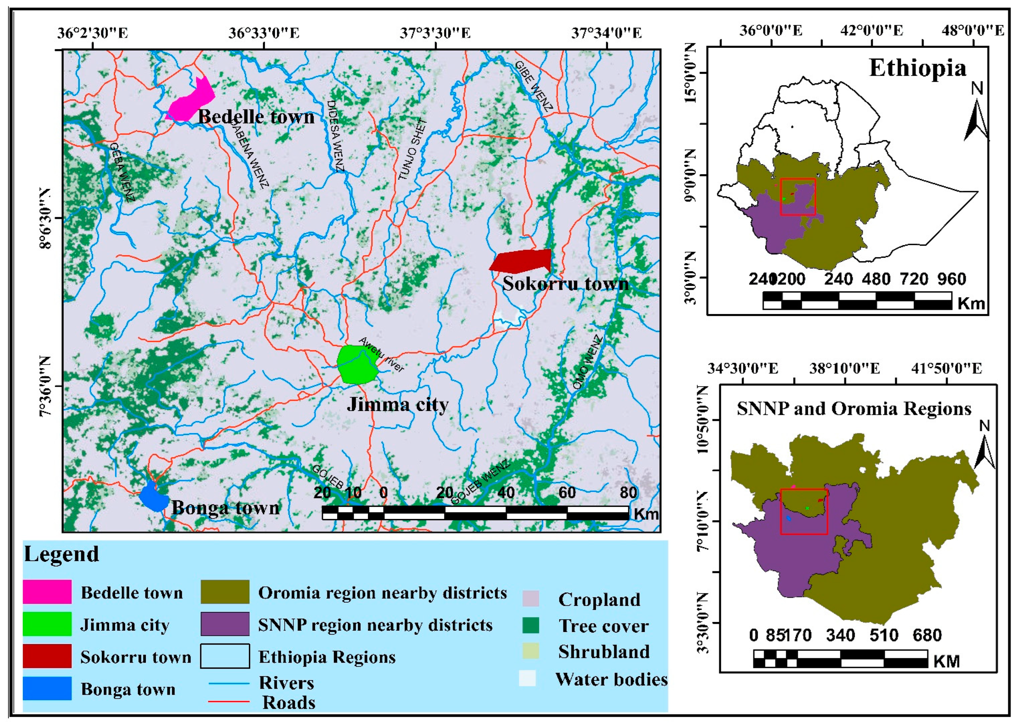
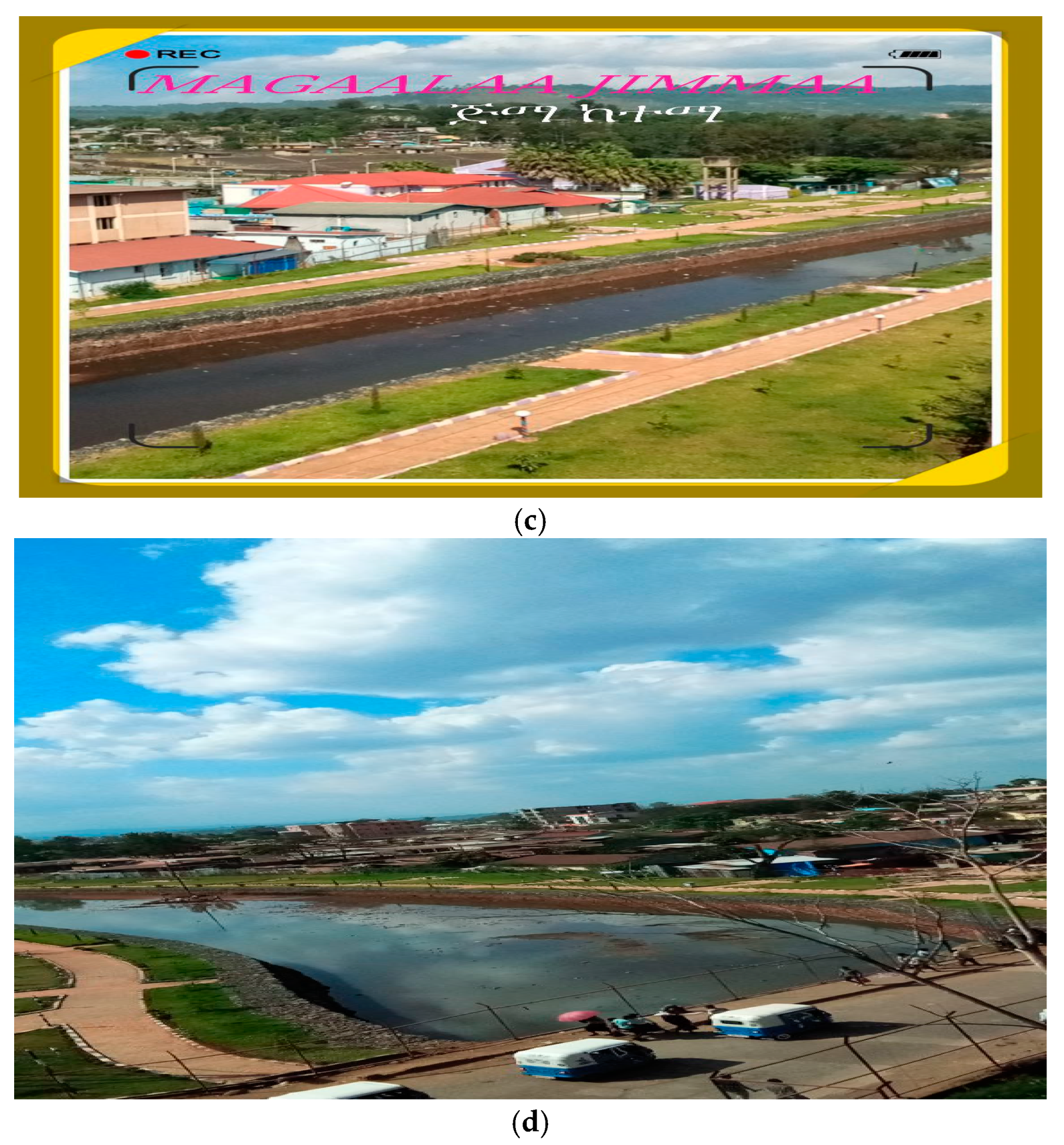
2.1. Study Area

This study was conducted in the southwest urban centers of Ethiopia, which lies between 7°22′ N and 8°45′ N and 36°23′ E and 37°40′ E, representing a grid box of 1° × 1°. It covers the extensive southwestern parts of the country, as depicted in Figure 1 and Table 1 below. The altitude of southwest Ethiopia ranges from high plateaus of over 2000 m to flat low-lying plains of 600 m. The three study urban centers Jimma, Bedelle, and Sokorru are situated in Oromia Regional State, and Bonga is located in the former South Nations, Nationalities, and Peoples (SNNP) of the newly established Southwestern Ethiopia Region (Figure 1).
Climatically, this region is characterized by a mean annual temperature of 14–20 °C and a mean annual rainfall total of 1700–2000 mm. The study area is considered as a mono-modal type of rainy season, with long rainy season spans from March to mid-November [27]. The southwest of Ethiopia (Figure 1) is considered as one of the country’s highest rainfall-receiving regions as documented by [28,29] with an observed decline in the rainfall total trend after the 1950’s onwards [29,30,31].
Figure 1. Map of study area. Note: for details of land use and land cover of urban centers, refer to [30].
Atmosphere 15 00595 g001
The main economic activities in the southwest urban centers of Ethiopia are mostly commerce, manufacturing, and small-scale cottage industries. Except for the newly established Industrial Park from 2018 in Jimma city and Bedelle, no large-scale industrial activity is found in these towns. The current city administration of the studied urban centers is structured from the city/town level to kebeles (the lowest administrative body in Ethiopia) with decentralized functions of a municipality. The total population, the total area, and the altitude meter above sea level (m.a.s.l) of each urban center are summarized in Table 1 and documented by reports [32,33]. Each of the four studied urban centers has its own historical establishment, land use type, and structural plan (master plan) to guide development, while none of them were established in the planned way. Jimma, which is the oldest city in southwest Ethiopia, was founded in the 1830s, and the municipality was established in 1942 under decree number 1/1942. Substantial portions of urban centers are green with trees planted and conserved along the roadside and compounded of residences and institutions, such as schools, churches, mosques, health centers, and universities ([30,34,35]; Figure 1).
Table 1. Geographical location and populations of studied urban centers.
S/No.Station NameLocationAltitude (Meter)Average Annual Rainfall (mm)Average Annual Mean Temp (°C)Total Area
(Hectare)
Total Population Projected in 2022 (Number)
Latitude (North)Longitude (East)
1Jimma7.6636.831725152320.410,200265,000
2Bedelle8.4536.332011209822.3287838,500
3Bonga7.2236.231779140219.5884644,046
4Sokorru7.9237.401928135921.530021,780
Source: Compiled by the authors based on [33,35].

2.2. The Methods of the Study

2.2.1. Research Design, Sampling Methods, and Procedures

In this study, a cross-sectional survey of a descriptive study design was employed as stated by [36]. In this case, the assessment of adaptation strategies practices to curb climate change impacts was surveyed in the urban centers of Jimma, Bedelle, Bonga, and Sokorru.
The following steps were undertaken, which are listed as follows; first, the four study towns and the concerned public officials were purposively selected taking Jimma City as the center-hub of urban areas in southwest Ethiopia. Secondly, the kebeles (the lowest administrative body) were selected by using a simple random sampling technique for each town. Following these approaches, seven kebeles were selected from each town/urban center. Thirdly, the number of households from each kebele was selected based on the sample proportional to the size of the households. The households were selected using a kebele household’s registration records as a sample frame, while the first households were selected by a simple random sampling technique for each kebele. The sample was obtained by taking the nth unit defined as the sampling ratio or skip interval, the total household population divided by the size of the sample P = N/n the skip interval [37,38]. The skip interval was 10,772 ÷ 384 = 28, and the first household for each kebele was selected randomly, and then at intervals of every 28th (pth) household, a study sample was taken. The duration of this research study includes the issue identification of the research site, a preliminary field visit, formulating questionnaires, focus group discussions, and key informant interviews for data collection carried out between June 2019 and September 2021. The period allotted for data collection was challenged by COVID-19 pandemic restrictions, but the researcher used safety protocols effectively throughout the study period.

2.2.2. Sample Size Determination

Because of the impracticality of surveying the entire population, taking a sample is preferable. From kebeles found in the study towns, households of 7 kebeles (3 from Jimma, 1 from Bedelle, 2 from Bonga, and 1 from Sokorru towns) were the target population of this study. Since no study has been conducted before, the population proportion is set at 0.5 (50%) based on the statistical rule to determine the required sample size [37,38], as formulated in Equation (1).
n = Z 2 p q d 2
where n = the desired sample size;
z = the standard normal variable at a required level of confidence (standard normal deviation);
p = the proportion in the target population estimated to have the characteristics being measured (if no estimate, 50% should be used);
q = 1 − p; d = the level of statistical significance set.
The value Z = 1.96 at a 95% confidence level, p = 0.5, q = 1 − 0.5 = 0.5, and d is the sampling error 5% = 0.05. For the present study, the sample size n was determined as follows:
n = Z 2 p q d 2 = ( 1.96 ) 2 × 0.5 × 0.5 ( 0.05 ) 2 = 384.16 384
The total number of urban households, which were included in the sample size, was therefore 384. Based on Kothari (2004), the sample size for each town/kebele was calculated using Equation (2).
n i = N i N n
where N = the total size of the population/household, Ni = the population size/household in each kebele, n = the total sample, and ni = the sample size from each kebele/stratum, the sum of the total size of n drawn from each kebele. The total number of households from four towns of seven kebeles N was 10,772. Thus, the total number of urban households, which were included in the sample size from each of the four towns, was 384 households (192 from 3 kebeles of Jimma, 41 from 2 kebeles of Bonga, 85 from 1 kebele of Bedelle, and 66 from 1 kebele of Sokorru towns) proportional to each town’s population size.

2.3. Data Sources

The main sources of data for this research were obtained from primary and secondary sources. The study population was taken from the total number of households of the four studied urban centers. Thus, the sampling unit of this study was a household of urban dwellers. Primary data were collected from sample urban households, key informants, group discussions, and through observation. Secondary data were collected from documents, books, the internet, journals, and reports as documented by the town’s administrations/municipality as well as their master plan/structural plan.

2.4. Data Collection Techniques and Analysis

To triangulate the findings, the data collection instruments employed were questionnaires, key informant interviews, focus group discussions, and field observations, which are discussed as follows.
For the survey using questionnaires, data were collected from households of the studied urban centers by using semi-structured survey questionnaires to collect detailed information on climate change adaptation strategies from each of the four towns. A total sample of 384 households was selected from four towns. The perception and observed experiences of households in four urban centers regarding the past thirty years’ trend and variability of rainfall and temperature as changes, the urbanization effect of land use land cover changes, population density, infrastructural development, emergency support during a disaster risk occurred, and adaptation strategy practices were assessed using questionnaires, which are also referred to in the Results section.
To conduct the key informant interview, this study used a pre-designed interview guide, which was semi-structured questionnaires distributed to the key informants with a total of 55 public officials in four towns (15 from Jimma, 14 from Bonga, 13 from Bedelle, and 13 from Sokorru).
In focus group discussions, a total of four focus group discussions with 40 participants were administered in four urban centers. Participants of the focus group discussion were members of the urban local community elders, development associations (CBOs), who have lived in each town for more than twenty years and are more than fifty years old, who are enriched with knowledge about climate change impacts and adaptation strategies of their home town. Each focus group consisted of 10 persons, and the discussion in each group was conducted for about 60 to 90 min which started and closed with blessings of local elders as per the norm and culture in each urban village of the study towns. The focus group discussion guide, which has open-ended questions, was used.
Field observation was guided by a semi-structured observational checklist and knowledgeable urban local person (a person who knows their home town well and was suggested by local people or authority) in each urban village of the study town. A transect walk of field observation was employed to visually observe and document urban adaptation strategies to climate change, environmental problems, or the environmental situation of the urban areas of each town to observe climate change’s driving forces and changes in that town in terms of land use change, population pressure, congested buildings, and the use of a plan to guide development as well as green and blue infrastructure coverage in the town.
The quantitative data were analyzed with relevant computing packages such as MS-excel 2016, SPSS version 21, R 4.31 version, ArcGIS 10.2 package system software was used to generate maps of the study area and the spatial distribution of households in the study towns. The quantitative data outputs were presented using tables, figures, charts, photographs, etc. Qualitative data were also organized and summarized in descriptive form. The analyzed quantitative data in number, percentages, and ratio were described and interpreted as well as compared with the outputs of other research findings.
To ensure the quality of the research, before the commencement of actual data collection, the study questionnaire was tested on five percent of the sample urban households not included in the study. This approach was intended to evaluate the appropriateness of the instrument for use, reactions of the respondents, and the time required, and finally, the correction was conducted. For ethical considerations, ethical research procedures were maintained throughout this study so that verbal consent and willingness to participate were ensured. The interviewer continued with due respect to community norms, beliefs, values, culture, and the confidentiality of the participants’ information.

3. Results

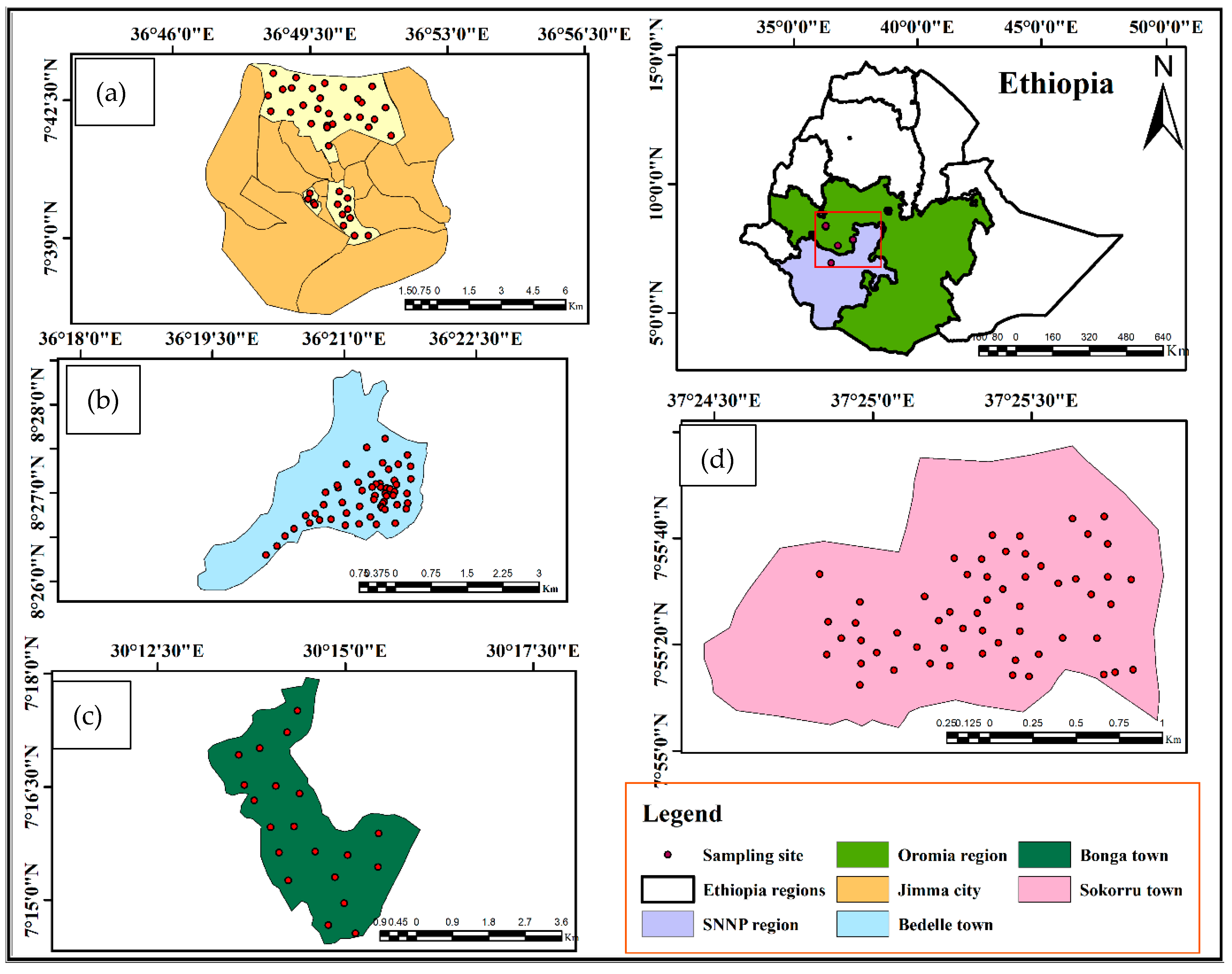
3.1. The Spatial Distribution of the Study Household Respondents

The spatial distribution of households that were included in the study towns is depicted in Figure 2 with x, y coordinates of their location as per the sample size of each urban center and respective kebeles included in this study. The coordinates of surveyed households that participated in four study towns were taken and documented for the validity of this study using a geographic position system (GPS), as shown in Figure 2.

3.2. The Assessment of the Temperature and Precipitation Changes in Urban Centers

The majority of the respondents (83%) disclosed that climate change was observed in the past three decades in urban centers. Most of the respondents indicated its causes as both natural and human (59%), followed by human/anthropogenic activity (36%) because of unplanned urban expansion and development activities in urban centers (Table 2). The majority of household respondents (90%) in the four study towns agreed that the temperature and hot days increased and changed in the past thirty years (Table 2). The impact of the increase in temperature was clearly perceived by the majority of the surveyed household respondents. The households in old roofed, crowded areas and high-rise building areas mainly shared the perception that indicated the temperature was rising due to the construction of high-rise buildings and their reflective materials, decrease in vegetation cover, and emissions from vehicles and factories as the main reasons (Industrial Park and Flour factories in Jimma, Brewery factory in Bedelle, and small-scale wood and metal processing factories). The majority (90%) of the respondents noticed that the climate of their town changed in the past thirty years, while 6% did not notice and the rest did not know (Table 2). Drought and both extreme events of temperature and rainfall happened in the past three decades in urban centers (Table 2).

3.3. Analysis of Adaptation Strategies in Urban Centers

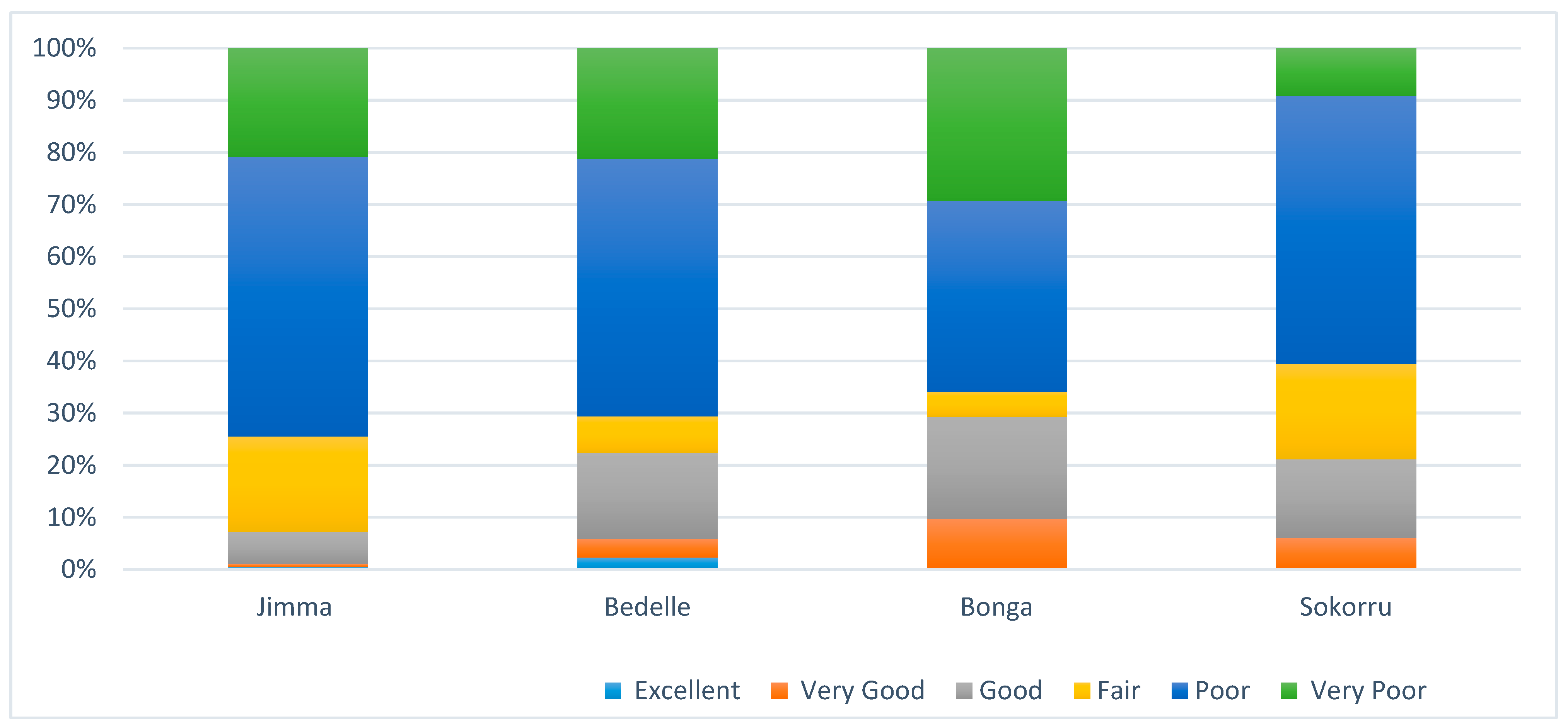
3.3.1. The Urban Planning Role of Climate Adaptation Strategies in Urban Centers

The majority (57%) of urban households in urban centers of southwest Ethiopia reported that their town has a structural plan, while 26% did not know whether their town has a plan or not (Table 3). The majority (43%) of urban households indicated that the land use plan is not regulated well, and the majority (82%) disclosed that the four urban centers have undergone massive land use land cover changes due to urbanization (Table 3). Regarding having adequate infrastructure such as sanitary facilities, standard roads, solid and liquid waste infrastructure, and drainage channels, the majority (65%) said they do not have adequate infrastructure, while few (25%) said their town has adequate infrastructure, while the rest did not know (Table 3).
The majority of key informants (91%) indicated urbanization triggered local climate change, while the rest (9%) did not (Table S3). The majority (96%) of the respondents agreed their town has increased in size and undergone massive land use changes (Table S3). The majority of key informants (84%) said their town has a structural plan or traditionally called a master plan, but more than half of the informants (51%) disclosed that it has not been regulated well and is not respected by urban actors including residential areas where illegal construction was common, while the rest aid it has been regulated well in the past thirty years. However, the reality on the ground indicates the need for attention to reverse illegal construction which varies across towns (Table S3).
In all urban centers, the focus group participants agreed that climate change was becoming more evident in the past thirty years, and unplanned illegal settlement expansion towards rural kebeles was observed. Moreover, the field observation ensures the opinion of households, focus group participants, and key informants who raised the challenge of plan-based urban development hampered by illegal urban expansion which in turn influences adaptation action implementation in urban centers.

3.3.2. Adaptation Strategies Analysis of Surveyed Households in Urban Centers

The adaptation mechanisms that the urban households practiced in the study areas include lifestyle modification like frequent bathing during hot winters, reduced paved surfaces, the use of air conditioners, urban greening like planting trees, ensuring green cover and park development, and building modification like extra-large window sizes and multiple room windows (Table 4). Almost half of the urban households (51%) disclosed that they have no adequate windows to ventilate their houses during extremely hot days or seasons, while the other half of the respondents have windows (Table 4). During extreme events and disaster in urban centers, the majority (75%) do not obtain health services, whereas a few (25%) obtain the services (Table 4). During infrastructural development from the design to implementation phase, the majority (51%) of the respondents considered climate adaptation, while 27% of them did not consider it (Table 4).
The majority of the households (54%) said that adaptation measures were taken in response to climate change, while 32% said no adaptation measures were taken (Table 5). The adaptation strategies practiced in the study towns were the relocation and identification of prone areas, the support of basic amenities during emergency services, the construction of protection walls, diversion ditches, and the clearance of waterways and rivers, the planting of trees and greenery, and park development, which vary spatially across interurban centers (Table 5). About 49% of households agreed that the relocation and identification of prone areas were not well implemented, while 38% said they were well implemented (Table 5).
Regarding the support of basic amenities, about 47% of households said they were supported, whereas a significant 40% were not supported well (Table 5). A total of 47% of households said that the construction of protection walls, diversion ditches, and the clearance of waterways/rivers were implemented while 41% said not implemented in urban centers (Table 5). The planting of trees and park development were well-implemented adaptation measures to climate change in the study urban centers as the majority of households disclosed that by 78% and 57%, respectively, while 36% said that greenery and park development were not implemented well, which needs the great attention of city administrators (Table 5).

3.3.3. Practical Implications of Climate Change Adaptation Strategies in Urban Centers

The triangulated results of the urban household survey, focus group discussion, key informant interview of concerned public sectors, and field observation identified many adaptation strategies which vary among urban centers. All the 21 possible adaptation strategies identified were grouped into eight groups based on extracted input from participants in this study, and the clustering of measures was also used in urban peri-urban adaptation measures identification analysis study by 3 The first groups contain mostly gray measures (2, 6, and 13), such as infrastructures for flood prevention, roads, culverts, and bridges Table 6. The second one includes the green adaptation (1, 3) of the planting of trees and green infrastructures. The third grouping was created including several preventive measures (7, 8, and 16) such as improvements in emergency response plans, early alert systems, and reliable communication networks between emergency teams and residents [Table 6]. The fourth green, gray, and ecosystem-based group (11) practiced on degraded areas as well as green and ecosystem-based practices (4) of natural resource management [Table 6]. The fifth is preventive measures (7, 8, and 16). The sixth one is the reactive measures of coping strategies (9, 15). The seventh group considers the urban planning (12, 14) aspects of adaptation [Table 6]. The eighth group is dominated by research- and environment-related measures (19, 20, and 21), which includes improvements in meteorological prediction, basin-scale vegetation management for flood prevention, and their application of possible economic incentives [Table 6]. It should be underlined that certain green measures can be an essential part of win–win strategies which are less expensive than their “gray” counterparts and can report both direct and indirect benefits. Direct benefits are adaptive or mitigating measures, whereas indirect benefits are through the improvement of urban and peri-urban aesthetics, carbon sequestration, and mitigation roles on the other hand (Table 6).
The adaptive capacities of the four study towns showed that half (51%) of the respondents suggested the towns were poor in reducing climate change extreme event’ impacts, while 20% said very poor, 14% fair, 11% good, 3% very good, and 1% excellent, which implied a great effort needed to increase the adaptive capacity of the municipality of urban centers in southwest Ethiopia (Figure 3; Table S1).

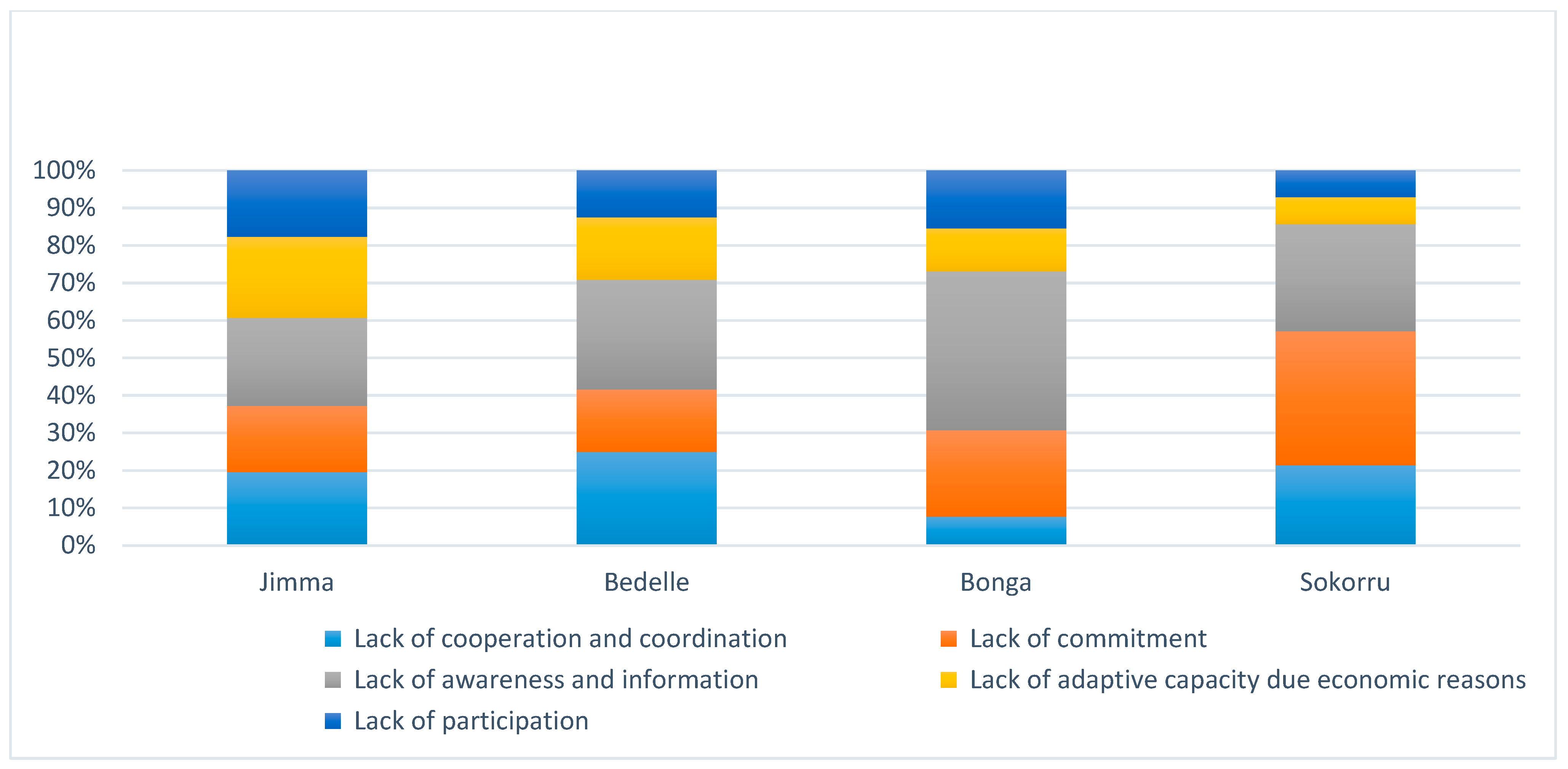
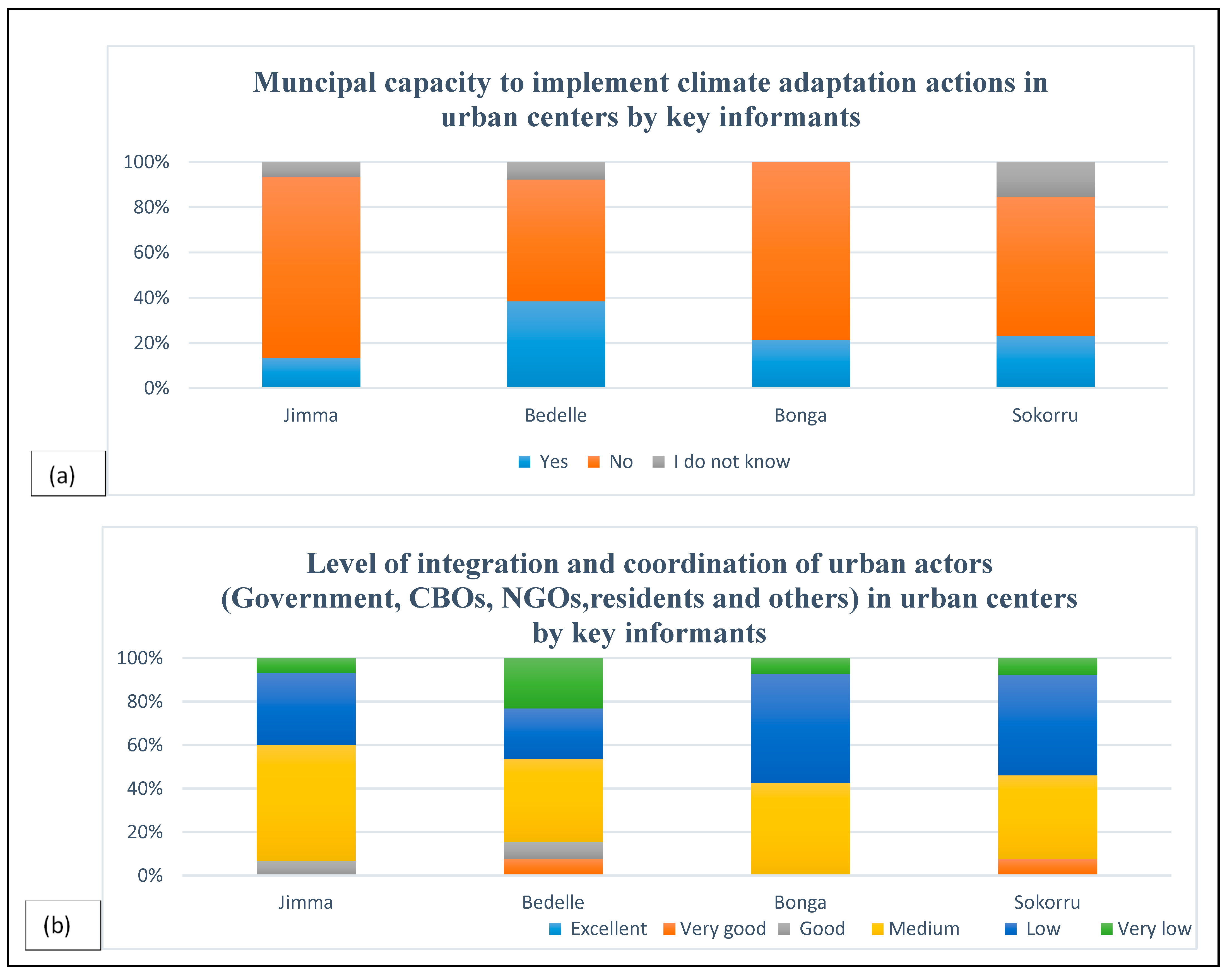
3.3.4. Analysis of Climate Change Adaptation Strategies by Key Informant Interviews in Urban Centers

Regarding the key informants’ education status, most of them had first degree followed by a second degree and diploma with 73%, 20%, and 7%, respectively (Table S2). For the position of key informants, the majority (42%) were process owners or department heads, 34% were experts, and the remaining 24% were office heads with the majority (69%) having experienced between 1 and 20 years, 10% between 21 and 30 years, and the rest greater than 31 years of experience (Table S2).
The majority of the key informants (93%) disclosed that climate change variability was observed in the past three decades in urban centers of southwest Ethiopia (Table S3). The key informants were asked how urban residents perceive climate change, and the majority of respondents said (84%) increasing while (11%) perceived decreasing, and the rest did not know (Table S3). Most of the respondents responded that the causes of climate change are both natural and human (54%), followed by human/anthropogenic activity (44%) because of unplanned urban expansion and development activities in urban centers (Table S3).
The key informants who were more aware than the other community regarding public organizations’ implementations said that the impacts of climate change that prevailed in urban residents’ livelihoods were infrastructural damage, impaired health, farming with a shortage of products and the loss of assets and life, coupled with major climate change-related problems such as flooding, drought, landslides, and others that happened in the last 30 years in urban centers of southwest Ethiopia (Table S4).
With regard to early warning and information provision in the past 20–30 years, the majority of key informants (74%) said that it was not provided, but a few (13%) said it was given, and the rest did not know (Table S5). The support given to the affected groups or households was not satisfactory by the majority (80%), and the rest (20%) said satisfactory. These signifies that the immediate actions or measures taken during disaster and the risk management of climate change in terms of support provided to affected peoples were rated medium followed by low. (Table S5). Regarding the roles of the municipality and any other disaster prevention institutions during addressing affected bodies, these include the provision of materials and support needed in an emergency, the coordination of urban actors, proactive planning, and the provision of information crucial to reduce the catastrophes as a means of adaptation (Table S5).
Most of the key informants agreed that there was a responsible body at the town level which is legally mandated to address climate change and environmental problems in their jurisdiction (Table S6). The policy environment in the application of the national adaptation plan at the town level was ranked at the medium level as pointed out by key informants whereas having a municipal adaptation plan at the town level, the majority (85%) of key informants agreed that the four study towns have no municipal adaptation plan, which plays a great role in reversing local microclimate change impacts and calls for the attention of city administrators to create livable and resilient cities in the future (Table S6). The key informants were asked about any actions of planned adaptation taken ahead of the risks that happened or if you take actions later after climate hazards or risks happened and said that the majority (76%) of measures were mostly taken in a reactive manner after the risks happened, while (17%) had no action in urban centers of southwest Ethiopia (Table S6).
The key informants argued that the constraints faced by urban residents of the four study towns to adapt to climate change were identified as a lack of awareness and information, lack of commitment, lack of cooperation and coordination, lack of adaptive capacity due to financial and economic reasons, and lack of participation in order of their justification (Figure 4; Table S7). The level of integration and coordination by government, community-based organizations, non-governmental organizations, and urban residents results of key informants showed that the majority rated it at a medium-average level (44%), followed by low (38%), very low (11%), good and very good (4%), each which needs great attention in realizing climate change adaptation actions in a local context (Figure 5; Table S8).

3.3.5. Analysis of Focus Group Discussions in Urban Centers

The four urban centers under study in southwest Ethiopia have their own historical establishment. The major issues of focus group discussions include perceptions towards climate change in the past thirty years, land use change and demographic change due to urbanization, major climate change impacts observed, which sectors and population groups were vulnerable, the capacity of urban residents and their municipality, legal frameworks of adaptation, and their future suggestions. The huge conversion of forests, cropland, water bodies, and wetlands to built-up construction for residential and other purposes was observed in their lifetime as a result of urbanization. The rate and magnitude of land use land cover changes vary spatially across urban centers as well as described for each urban center in the previous study [30]. For example, in Jimma, many indigenous tree species and medicinal plants were common and used for different healing and environmentally conducive springs found here and there used for human and livestock purposes. The bus station, around Dololo river ways, Ginjo, Boye Swamp, which is under threat due to human intervention, and Kitto airport places where water towers of wetlands that are currently undergoing massive conversion to buildings, whereas Bacho-Bore, Mantina, Ferenji Arada, established during Italians invasion were forest areas except some routes. Jimma served as a trade center for the western parts of the country where Hermata was the market place known in the center of the city, and Jiren served as a palace for the seat of King Abbajifar during the end of the 18th century.
The participants agreed that climate change was evident among that identified by discussion; rain decreases from its past frequency compared with the present, drought increases, medicinal plants are lost, the population grows abruptly through migration, forest and vegetation coverage decline, water and wetlands diminish, Jimma grows in an unplanned way, before we drank water from springs, now rivers are highly polluted, and they recall their childhood of bathing and swimming, agricultural product prices rise, the problem of solid and liquid waste management, the lack of open spaces for public uses like sports fields and low infrastructure development, and the lack of the consideration of climate change in development like the building of infrastructures were among the major environmental, social, and economic problems pointed out by the focus group participants.
In the later period, even if Jimma City and the other study towns have developed a structural plan, which was not respected by all urban actors, it is still necessary to call for all responsibility of the government and the urban dwellers of each town. Bedelle, the town of “Abba Boku-Shuramo Gota”, was a forest area with many spring waters before 30 years ago and has undergone massive land cover changes as a result of urban expansion in an unplanned manner. Similarly, Bonga, the former Keffa Kings, prioritized nature conservation and socially welcoming peoples of high social norms, the hub of biodiversity including coffee. Since forty years ago Bonga has shown that the forest coverage declined and warming level increased and there is population growth due to migration from rural to urban centers, inducing a more climate change in the latter 30 years. Sokorru was sparsely populated by farmer houses by not more than 10 households in their lifetime, and based on what was heard from their grandfathers, it was a forest area that emerged to the town level having its own municipality. Currently, which they called Odaa Abba Bora and was the market center in that long distant period.
In the past thirty years, flooding, the warming of the city, drought, and landslides have become common, which poses impacts due to microclimate change. Flooding was a common problem boldly raised by the four study towns, but in the case of Jimma, it was worst during the years 2000, 2015, and 2019 from May to August displacing households in Hermata Merkato and Bacho Bore kebeles near Awetu River. Also, in Bonga and Bedelle, flooding causes serious damage to properties near the lower altitudes of rivers. Barta River flooding in the Sheta kebele of Bonga caused serious damage. Stormwater runoff causes severe catastrophes in Sokorru due to the topographic landscape during the rainy season. The urban heat island effect of warming in the urban core was commonly raised as increased warming from time to time became evident in all urban centers as coined by the group participants of each town.
Landslides were common in all study urban centers with the highest in Sokorru followed by Bonga, Bedelle, and Jimma, while the agricultural sector was highly impacted by climate change. The area known by residents called 980 is situated above saint Gabriel Church located at a higher altitude; the landslide that happened was rehabilitated with green infrastructure to stabilize the degraded areas in Bonga Town administration by public participation. In Bonga, indigenous trees have been depleted due to urban expansion; as a result of heavy rainfall, infrastructure damage like bridges and culverts have been taken away, household property damage, price rising due to agricultural production decline, and relocation affected peoples from Mehal Ketema and was conducted as pointed out by focus group participants of Bonga Town. In the rest of Jimma, Bedelle, and Sokorru, the degraded areas were reclaimed by planting trees and soil conservation practices to stabilize the areas. Also, the common environmental problems commonly raised by the observation of all urban centers′ focus group participants were the depletion of forest and water bodies, population growth, soil erosion, biodiversity loss, the reduction in tree and shrub species, the structure change in the government, the decline in rainfall, the human and livestock disease increase, infrastructure damages, urban heat island increase/warming, and massive land use land cover changes due to urban expansion.
The solutions suggested by the group participants were community participation and involvement from planning to implementation, proactive planning, the proper response of emergency responses, awareness creation, the planting of trees and park development, strong land policy enforcement through structural plan-based development, physical and social infrastructure development, riverside buffer protection, protection walls and greenery near rivers, the use of solar energy technologies, drainage channel upgrading, the enforcement of building codes, slum area upgrading, proper solid and liquid waste management, attitude changes in urban residents, infrastructure development supported by research, and the roadside plantation of shade trees, which were among the major suggested measures of coping strategies to address the environmental problems triggered by urbanization. Also, urban greenery is the best practice to address the greenhouse gases emitted from transport sector motor vehicles, improper solid and liquid waste in unsanitary disposal sites, and small-scale industries which vary depending on urban center development. The focus group participants agree that all the study towns have low adaptive capacity to combat climate change in their towns.

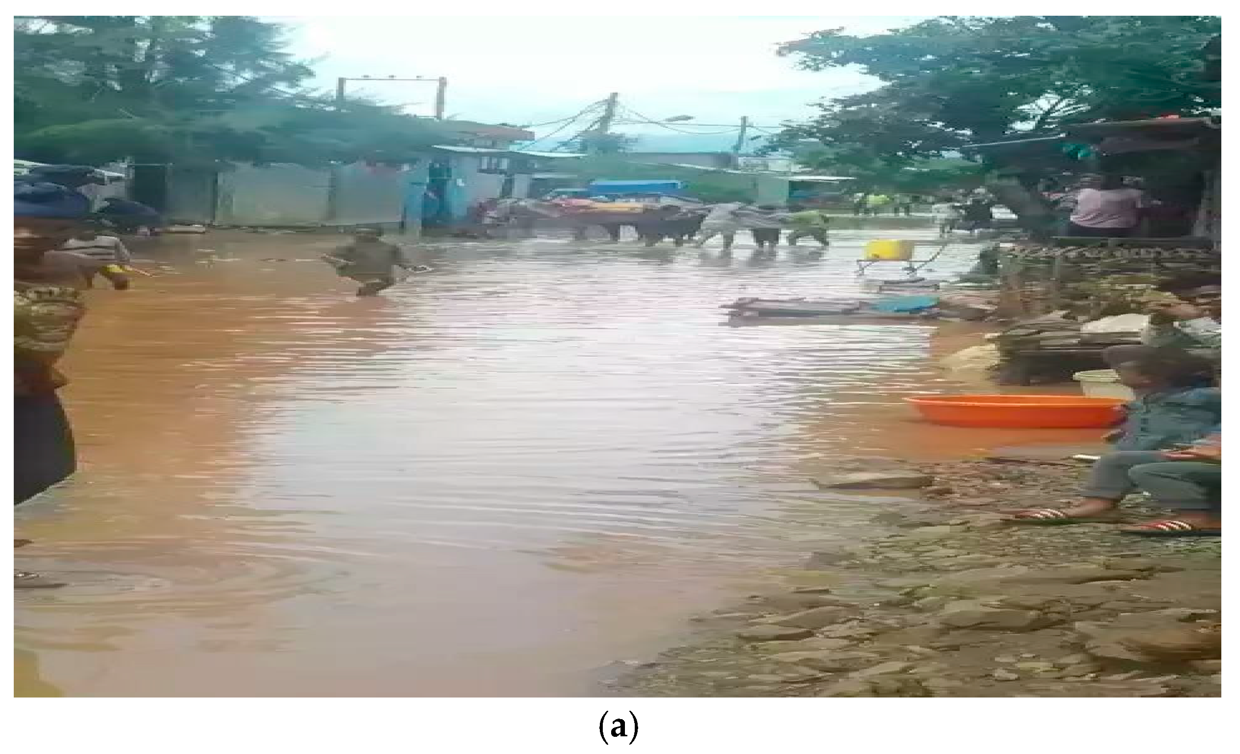
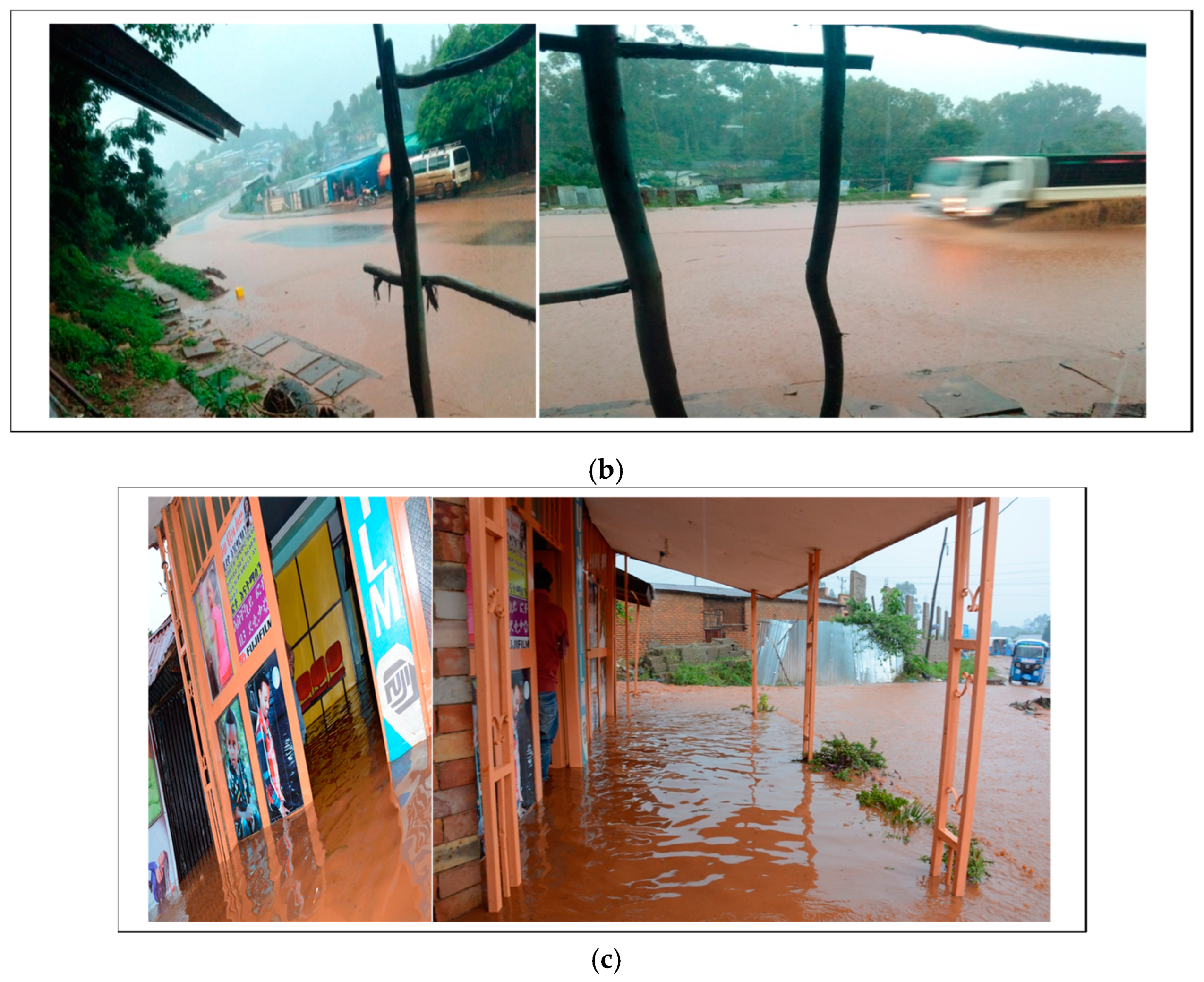
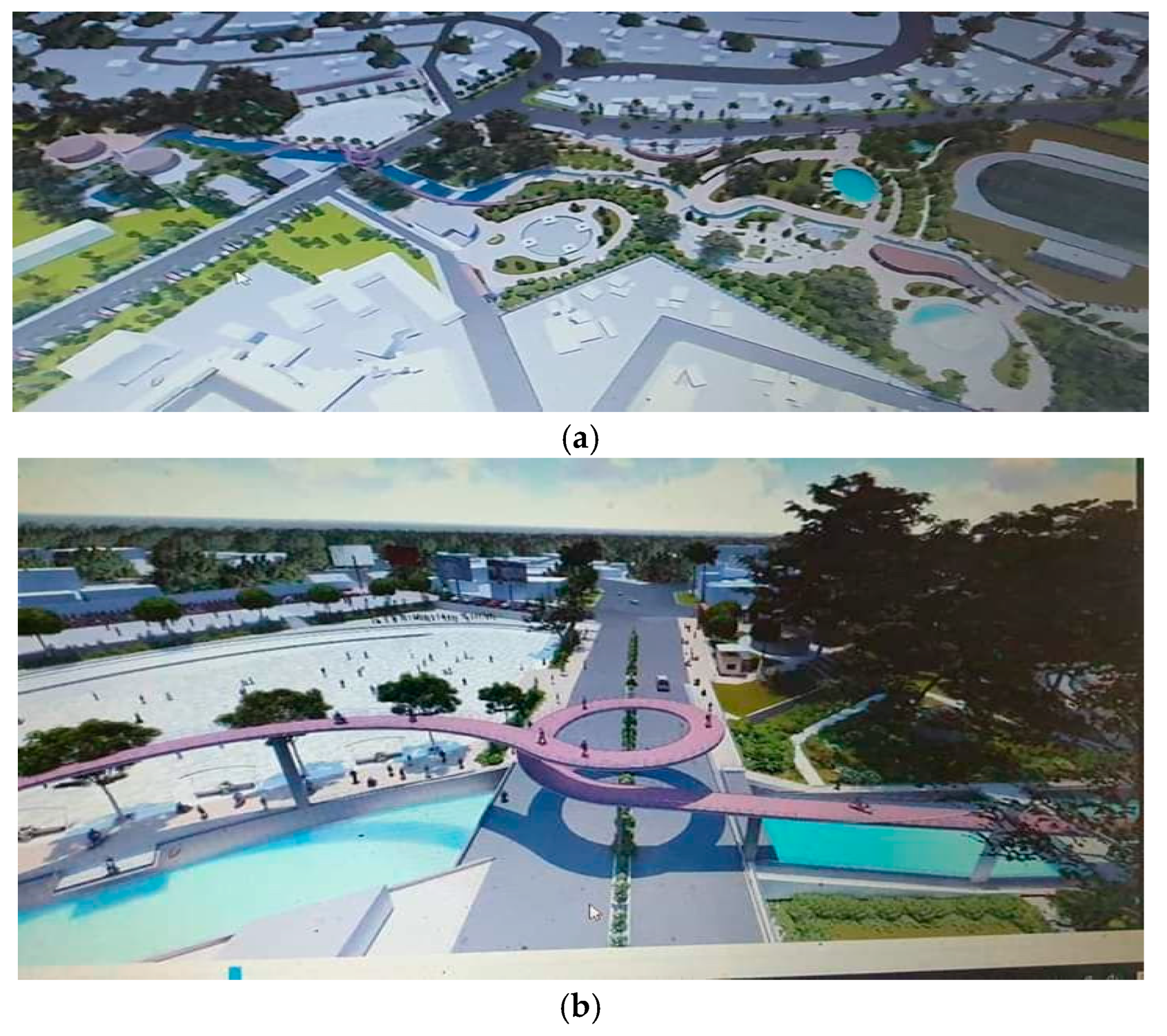
3.3.6. Analysis of Field Observation in Urban Centers

A semi-structured observation checklist to assess climate change impacts′ footprints observed urban expansion activities, response to address the vulnerable groups or affected areas, riverside construction, the observation of urban core and outskirts in buildings’ density, population density, urban heat, the availability of infrastructure development, and the observation of adaptation strategies or actions/practices for climate change in urban centers, which were assessed by a transect walk of field observation. These field observations were used to obtain first-hand information on environmental problems, climatic hazards, the urban vulnerabilities of local communities and municipalities, and adaptation measures in place. Almost all urban centers have undergone massive land use land cover changes as a result of unplanned urban growth to rural outskirts due to illegal settlements in Jimma, Bedelle, Bonga, and Sokorru (Figure 6, Figure 7 and Figure S1). Also, a high population increase was observed in Jimma and a low in Sokorru, comparatively. In most of the studied urban cores, the vegetation cover was very low or did not exist, and there were mostly high-rise buildings which exacerbate the urban heat island effect of warming perceived physically, and the residents feel hot days, especially during winter afternoons from 1 p.m. to 4 p.m. (Figure S1). The buffer zone near the river in all towns was not maintained, and construction on the riverside was common (Figure 6). There was a good start of greenery and tree planting activities for Jimma City riverside development (Figure 7) by both the residents and institutions developing in their compartments which vary across inter-urban centers. Flooding, warming in the urban core of commercial business district areas (CBDs), and landslides in steep areas were observed as climate hazards and risks which imposed damage on properties, wellbeing, and on infrastructure; the magnitude varies across the studied urban centers (Figure 6, Figure 7 and Figure S1).
The use of a structural plan to guide development in Jimma, Bedelle, and Bonga towns was implemented. Meanwhile, it is crucial to appreciate the good start to enhance the adaptive capacity through gray and green infrastructure, greenery and park development, and an asset management plan. The Awetu riverside gray and greenery development and a safety net program (by direct support and public work means in three kebeles nearly 1000 household beneficiaries, which are scaled up to other kebeles). The project is used to address and benefit low-income urban poor initiated by Jimma City Municipality to adapt their residents and actors towards challenges of climate change variability (Figure 7).
From the overall findings, currently, the responsible organizations are, at the federal level, environment, forest, and climate change commissions, and at the regional level, regional governments and environmental sectors to organize adaptation implementations, but many ministries and sectors are also responsible as well. In an urban context, the ministry of urban development and construction, at the federal level, regional urban development and construction bureaus, and at the urban center level, the city/town administration’s environment and natural resource offices are the responsible organizations, while municipal authorities and other sectors are also obliged to implement mainstream adaptation strategies. The implementation falls short of the cooperation and participation of urban actors as per the national adaptation plan at lower tiers of the government due to the difference in the structure of the government at the local level.

4. Discussion

The demographic and socioeconomic characteristics of the household respondents in the four urban centers (Jimma, Bedelle, Bonga, and Sokorru) were assessed. The income of the respondents is highly varied, and half (51%) of the respondents have a low monthly income, while the income of the household is used for many other family members, especially dependents, children, and elders. This result was comparable with [39] who explains that many family members can raise the opportunity of other family members to support family incomes, both from primary sectors in their household community and others. Most of the households in the study towns depend on available local support resources, so the disturbance of these resources directly influences their income generation, which hampers household savings [40]. Households that have no access to sanitation in their residence or building have a greater sensitivity to climate change; therefore, increasing access to sanitation is an important strategy for climate change adaptation [41,42,43]. This research finding was similar to the results of reports of adaptation by urban households in the IPCC [4,5] and the study of adaptation measures taken by urban residents in Addis Ababa [43].
Well-planned cities are more resilient and conducive to their residents in curbing the impacts of climate change than unplanned ones [44]. The major climate change hazards frequently occurring in the studied urban centers were warming or heat waves, riverine or flash flooding, drought, and landslides, the identified challenges increasing in the past thirty years from household surveys, key informant interviews, focus group participants, and field observation results. This study′s findings were similar to adaptation measures taken by urban residents and urban planning at the expense of urban expansion through illegal settlements in Addis Ababa as reported by [43] and differ from the governance and adaptation implementation of megacities like Dhaka, Lagos, and Hamburg [45] which differ spatially across a local context due to the difference in the political commitment and economic development of megacities from urban centers in southwest Ethiopia.
Our research findings showed that the main adaptation strategies to address the risks of climate change that have been identified were through life modification and early warning systems, proactive disaster management planning, increasing the adaptive capacity of households and municipalities, awareness and climate information provision, identifying hotspot areas, and gray and green infrastructure development at the urban center level. This study’s findings of adaptation implementation in urban centers vary spatially to address climate change impacts and was similar to a recent report of the IPCC [5] which documented progress in adaptation planning, and implementation has been observed across all sectors, urban centers, and regions, creating multiple benefits which are unevenly distributed with observed adaptation gaps prioritizing immediate and near-term climate risk reduction.
The finding of this study pointed out that urban planning was regarded as a tool for addressing urban climate change challenges at the local level through community participation. This spans from planning to implementation shortfalls in consideration of proactive climate change adaptation to face unprecedented climate change in urban centers. The finding is similar to the results of a previous study that reported about the synergies in design, urban health planners, and architects in making a healthy city environment [46].
The aim of the households surveyed, key informants of public sectors, focus group participants, and field observation results of triangulation depicted that climate change signals were more evident in the recent past of thirty years, mainly due to the urbanization scheme. Our study suggested that an increase in community participation and all urban actors contributed to a reduction in climate change impacts on people and infrastructure through adaptive capacity improvement. Most of our key informants narrated that “tomorrow will be made up of today’s action in creating better tomorrow for future generations”. This finding was in agreement with building-resilient infrastructures and nature-based solutions, which can adapt or mitigate climate change impacts and improve the aesthetics, access, and connectivity of intraurban centers which calls for a municipal manager’s allocation of proper land for climate adaptation and mitigation measures using the structural plan of respective towns to address climate change in the future [47,48].
The planning and design of urban greening and park development with increased green space as adaptation and mitigation strategies for climate change can result in multiple co-benefits to realize having a conducive environment of livable healthy cities [21]. The provision of green areas contributes to improved air quality, reduces heat island effects, and provides shade from the sun, increasing both mental and physical health as well as protecting and balancing a wider microclimate environment while trapping GHG emissions of the urban centers under study. This result coincides with many findings as documented by researchers as many adaptation strategies are diverse and often involve hybrid physical, nature-based solutions and increasingly integrated management plans. Nature-based adaptation strategies in urban centers—including street trees, green roofs, green walls, and other urban vegetation—can reduce heat and extreme heat by cooling private and public spaces in high agreement [5]. Also, agreeing with the study result of urban climate models showed that increased vegetation cover results in reducing both mean air temperatures and extreme temperatures during the warming of heat waves through the increase in shading and evapotranspiration by their cooling roles [49,50,51,52,53].
The basic findings showed whether a municipality has a map of climate hotspot areas or not and whether the three urban centers Jimma, Bedelle, and Bonga have disaster and risk management plans required as criteria by the urban institutional and infrastructural development project initiated by the World Bank and Urban Development and Construction Ministry to capacitate the urban development of cities in the country. The project links both gray and green infrastructure that considers greenery and park development as the best strategies to reduce the impacts of climate change in addition to early warning systems, knowledge sharing, and information to the population, ensuring the participation of urban actors along with the monitoring and implementation of the plans. These findings were similar to a recent report by the IPCC [5] which indicates that increasing adaptive capacities minimize the negative impacts of climate change and implementing a range of adaptation options such as disaster risk management, early warning systems, climate services, and risk spreading and sharing across sectors maximizes greater benefits to other adaptation options when combined with high confidence.
Gray/physical infrastructure is a priority for adaptation because its performance is sensitive to climate (particularly extreme events), and decisions on design and renovation have long-lasting implications to reverse the catastrophes in urban centers [54] which avoids longer-term impacts on society, the economy, and the environment and will demand future investment to be undertaken in the context of the risks of climate change [55,56] through architectural and urban design building regulations (building codes and guidelines) and behavioral change during extreme weather events [57]. Also, the need to optimize the placement and assess the cumulative effect of the wet-weather control strategies and measures as a key preliminary step (both structural and not structural) has to be implemented as well in addressing surface water safeguard requirements in urban areas [58].
The climate adaptation strategies or measures were based on peculiar urban center spatial and local context problems which could be curbed by the coordination, integration, and participation of all urban actors’ synergy of local governments, residents, policymakers, community leaders, research institutions, and private sectors which were well emphasized in the recent third national communication of Ethiopia [59]. Also, urban planners, architecture, and engineering professionals’ role in making informed decisions in planning urban land use that addresses climate change impacts and promotes a healthy environment for urban dwellers was also raised by study participants. This finding was in agreement with a recent report by the IPCC [5] that an increasing number of adaptation responses exist for urban systems, but their feasibility and effectiveness are constrained by institutional, financial, and technological access and capacity, which depend on coordinated and contextually appropriate responses across physical, natural, and social infrastructure, which calls for integrated multi-sectoral solutions.

5. Conclusions

Adaptation strategies in urban centers varied considerably based on the adaptive capacity of municipalities, residents, and the awareness of institutions, households, and community organizations. Climate change poses challenges and a threat to the sustainable development of the four urban centers of southwest Ethiopia. The adaptive capacity of the municipalities of the studied urban centers was low coupled with a poor cooperation, participation, and integration of urban actors. The topography of the four urban centers differs across urban centers spatially triggering their susceptibility to climate change impacts like flooding on steep terrain, soil erosion, and stormwater runoff affecting the mountainous and riverine areas of the studied urban centers. Furthermore, urban dwellers living in the vicinity of these areas have been severely affected due to improper road and drainage network problems which caused the flooding of roads and riverside households. Also, the amplified risk of flooding coupled with the warming of the urban heat island effect in the urban core due to the dense building construction of less green coverage imposes challenges on urban dwellers in city centers.
The integration of urban planning and land development with proactive climate adaptation is still very limited due to the weak regulation of structural plan implementation and low capacity which hindered planned urban growth. Among the best practice of riverside development initiated in Jimma City by implementing both the gray and greenery infrastructure of a huge investment by the urban institution and infrastructural development (UIID) project financed by the World Bank and Jimma City Administration to curb the rampant catastrophe of Awetu River flooding during the rainy season and also creates an employment opportunity to be scaled up. This study shows that there is a good beginning by Jimma, Bedelle, and Bonga to increase their capacity through UIID projects which differ across towns to make resilient urban centers. But the Sokorru municipality administrators or managers have to focus on low-cost greenery development to high-cost gray or physical infrastructure step by step through the participation of urban actors.
Even though it is impractical to fully halt climate change, it is better to assist city authorities in their efforts for mainstream adaptation into urban planning practice, increase awareness and participation, enabling the policy and strategy, technology, monitoring, and evaluation of implementation gaps through national and sub-national bodies in a participatory and integrative manner by all urban actors. The main challenges in addressing the climate change impacts were triggered by illegal settlements in the four studied urban centers coupled with unplanned urban growth, compromising their microclimate environment due to evident climate change signals in the past recent three decades. The findings of this study call for a proactive consideration of the synergies between climate change adaptation and urban planning.
Based on the gaps identified in the study of urban centers, we recommend the urgent devising of a municipal adaptation plan that address the local microclimate context to curb climate change impacts as a proactive adaptation and mitigation climate action through approval by respective City Councils of the urban centers as law in the urban jurisdiction by all urban actors. To that end, the inclusion of climate adaptation in the urban planning process at all scales of urban development initiatives considering the local context of the studied urban centers in particular and other cities of the country is recommended. Since most adaptation plans are geared mostly toward the national level, the ministry of urban development and construction, regional governments, and city administrators focus on creating the resilient cities of tomorrow starting today, through the implementation of decentralized climate change adaptation measures to promote sustainable urban centers′ development in the era of inevitable climate change.

Supplementary Materials

The following supporting information can be downloaded at https://www.mdpi.com/article/10.3390/atmos15050595/s1.

Author Contributions

T.D.G. was responsible for all activities of the research process such as the design, data collection from the field, data compilation, and entry and data analysis, the interpretation of the results, editing, and the writing up of the manuscript. The three authors D.K.D., A.W. and W.G. were involved in supervising from design to data collection, contributed to framing the manuscript, made valuable inputs, edited, and commented on improving the quality of the manuscript during the write up of the manuscript. All authors contributed to the manuscript. All authors have read and agreed to the published version of the manuscript.

Funding

This research received no external funding.

Institutional Review Board Statement

Not applicable.

Informed Consent Statement

Not applicable.

Data Availability Statement

The data supporting the conclusions are presented in the article but others data will be made available on request by the corresponding authors. The data are not publicly available due to privacy.

Acknowledgments

The authors would like to acknowledge the following institutions in the acquisition of necessary data and technical support for this work: Jimma, Bedelle, Bonga, and Sokorru City Administration Offices, study participant households of four towns, and West Oromia Meteorological Services Center. We are also grateful to Jimma University College of Agriculture and Veterinary Medicine for writing supporting letters to study towns and institutions to undertake the ethical procedures of the research. Our heartfelt thanks go to Chris Funk, Director of the Climate Hazards Center (CHC) at the University of California Santa Barbara (UCSB) for making this article publishable by covering the Article Processing Charge payment. Our thanks go to Gemechu Dabessa for his technical expertise and support to encode the GPS-collected fieldwork data and generate maps using household geolocation coordinate points of four towns using ArcGIS 10.2 software version. The authors also forward great thanks to those friends who stood on our side during fieldwork, shared information during the survey period, and extended their technical support during the research work. Great thanks also go to all anonymous reviewers for their valuable comments and remarks during the review process for the further improvement of the manuscript.

Conflicts of Interest

The authors declare no conflict of interest.

References

  1. United Nations. World Urbanization Prospects: The 2018 Revision; United Nations: New York, NY, USA, 2018; pp. 1–126. [Google Scholar]
  2. Satterthwaite, D. Adapting to Climate Change in Urban Areas: The Possibilities and Constraints in Low- and Middle-Income Nations; International Institute for Environment and Development: London, UK, 2008; Volume 1, pp. 1–91. [Google Scholar]
  3. Martinez, L.; Leon, E.; Al Youssef, S.; Katrina Karaan, A. Strengthening the health lens in urban resilience frameworks. Cities Health 2020, 4, 229–236. [Google Scholar] [CrossRef]
  4. IPCC. Climate Change 2014: Impacts, Adaptation, and Vulnerability; Part A: Global and Sectoral Aspects. Contribution of Working Group II to the Fifth Assessment Report of the Intergovernmental Panel on Climate Change; Cambridge University Press: New York, NY, USA; Cambridge, UK, 2014; pp. 3–30. [Google Scholar]
  5. IPCC. Climate Change 2022: Impacts, Adaptation, and Vulnerability; Contribution of Working Group II to the Sixth Assessment Report of the Intergovernmental Panel on Climate Change; Pörtner, H.-O., Roberts, D.C., Tignor, M., Poloczanska, E.S., Mintenbeck, K., Alegría, A., Craig, M., Langsdorf, S., Löschke, S., Möller, V., et al., Eds.; Cambridge University Press: Cambridge, UK, 2022; pp. 1–36. [Google Scholar]
  6. IPCC. Summary for Policymakers. In Global Warming of 1.5 °C. An IPCC Special Report on the Impacts of Global Warming of 1.5 °C above Pre-Industrial Levels and Related Global Greenhouse Gas Emission Pathways, in the Context of Strengthening the Global Response to the Threat of Climate Change, Sustainable Development, and Efforts to Eradicate Poverty; WMO: Geneva, Switzerland, 2018; pp. 1–30. [Google Scholar]
  7. IPCC. Assessment Report 6 Climate Change 2021: The Physical Science Basis-Summary for Policymakers (SPM); Cambridge University Press: Cambridge, UK, 2021; pp. 1–40. [Google Scholar]
  8. Sheppard, S.R.J. Making climate change visible: A critical role for landscape professionals. Landsc. Urban Plan. 2015, 142, 95–105. [Google Scholar] [CrossRef]
  9. Aaheim, A.; Berkhout, F.; McEvoy, D.; Mechler, R.; Neufeldt, H.; Patt, A.; Watkiss, P.; Wreford, A.; Kundzewicz, Z.; Lavalle, C.; et al. Adaptation to Climate Change: Why Is It Needed and How Can It Be Implemented? CEPS Policy Brief No.161; Centre for European Policy Studies: Brussels, Belgium, 2008; p. 161. [Google Scholar]
  10. Douglas, I. Unjust waters: Climate change, flooding and the urban poor in Africa. Environ. Urban. 2008, 20, 187–205. [Google Scholar] [CrossRef]
  11. Satterthwaite, D.; Bartlett, S. Editorial: The full spectrum of risk in urban centers: Changing perceptions, changing priorities. Environ. Urban. 2017, 29, 3–14. [Google Scholar] [CrossRef]
  12. Satterthwaite, D.; Archer, D.; Colenbrander, S.; Dodman, D.; Hardoy, J.; Mitlin, D.; Patel, S. Building Resilience to Climate Change in Informal Settlements. One Earth 2020, 2, 143–156. [Google Scholar] [CrossRef]
  13. Kumsa, A.; Jones, J.F. Climate change and human security in Africa. Int. J. Sustain. Dev. Ecol. 2011, 17, 453–461. [Google Scholar] [CrossRef]
  14. Mukheibir, P.; Ziervogel, G. Developing a municipal adaptation plan (MAP) for climate change: The City of Cape Town. Environ. Urban. 2007, 19, 143–158. [Google Scholar] [CrossRef]
  15. Roberts, G.; Parrotta, J.; Wreford, A. Current adaptation measures and policies. In Adaptation of Forests and People to Climate Change—A Global Assessment Report; IUFRO World Series; IUFRO: Helsinki, Finland, 2009; Volume 22, pp. 123–133. [Google Scholar]
  16. Phalatse, L. Capacity building needs and opportunities from the perspective of municipal government. In Prepared for the Workshop to Assess Needs and Opportunities, African Climate Change Fellowship Programme; University of Dar Es Salaam: Dar Es Salaam, Tanzania, 2008. [Google Scholar]
  17. Paul, W.; Hunt, A. Climate change impacts and adaptation in cities: A review of the literature. Clim. Chang. 2011, 104, 13–49. [Google Scholar]
  18. James, R.; Washington, R. Changes in African temperature and precipitation associated with degrees of global warming. Clim. Chang. 2013, 117, 859–872. [Google Scholar] [CrossRef]
  19. Cities Alliance. About CDS [Online]. 2017, pp. 1–128. Available online: http://www.citiesalliance.org/about-cds (accessed on 22 February 2022).
  20. FDRE. Ethiopia’s Climate-Resilient Green Economy: The Path to Sustainable Development, s.l.: Federal Democratic Republic of Ethiopia; United Nation: New York, NY, USA, 2011; pp. 1–16. [Google Scholar]
  21. NAP. Ethiopia’s National Adaptation Plan; Ethiopia’s Climate Resilient Green Economy; NAP: Addis Ababa, Ethiopia, 2019; pp. 1–86. [Google Scholar]
  22. MoA—(Ministry of Agriculture and Forestry). Ethiopia’s Climate Resilient Green Economy. Climate Resilience Strategy Agriculture and Forestry; Ministry of Agriculture and Forestry: Addis Ababa, Ethiopia, 2015; pp. 1–70. [Google Scholar]
  23. MoWE—(Ministry of Water and Energy). Ethiopia’s Climate-Resilient Green Economy Climate Resilience Strategy: Water and Energy; Ministry of Water and Energy: Addis Ababa, Ethiopia, 2015; pp. 1–12. [Google Scholar]
  24. FDRE (Federal Democratic Republic of Ethiopia). Intended Nationally Determined Contribution (INDC) of the Federal Democratic Republic of Ethiopia Submitted to the Secretariat of the UNFCCC as Part of the Preparations for the Paris Climate Agreement Achieved in December 2015 at the Conference of Parties 21 Addis Ababa, Ethiopia; UNFCCC: Bonn, Germany, 2015; pp. 1–15. [Google Scholar]
  25. Kidemu, M.; Anjulo, A. Determinants of women adaptation to the potential impacts of climate change: A case study in Assosa Woreda, Benshangul Gumez Region, Western Ethiopia. J. Sci. Res. Rep. 2016, 11, 1–11. [Google Scholar] [CrossRef]
  26. Mayson, F.; Bisci, C.; Billi, P. The Climate of Ethiopia. In Landscapes and Landforms of Ethiopia; Springer: Dordrecht, The Netherlands, 2015; pp. 1–21. [Google Scholar]
  27. Funk, C.; Rowland, J. A Climate Trend Analysis of Ethiopia; U.S. Geological Survey Fact Sheet 2012–3053; USGS: Sioux Falls, SD, USA, 2012. [Google Scholar]
  28. Getenet, K.; Bewket, W. Variations in rainfall and extreme event indices in the wettest part of Ethiopia. SINET 2009, 32, 129–140. [Google Scholar]
  29. Korecha, D.; Sorteberg, A. Construction of Homogeneous Rainfall Regimes for Ethiopia. Int. J. Climatol. 2013, 49, 7681–7697. [Google Scholar]
  30. Dessu, T.; Korecha, D.; Hunde, D.; Worku, A. Long-Term Land Use Land Cover Change in Urban Centers of Southwest Ethiopia from a Climate Change Perspective. Front. Clim. 2020, 2, 577169. [Google Scholar] [CrossRef]
  31. Gemeda, D.O.; Korecha, D.; Garedew, D. Evidences of climate change presences in the wettest parts of southwest Ethiopia. Heliyon 2021, 7, e08009. [Google Scholar] [CrossRef] [PubMed]
  32. CSA. Population Statistical Abstract. Addis Ababa: Federal Democratic Republic of Ethiopia, Population Census Commission. Democratic Republic of Ethiopia, Population Census Commission; CSA: Addis Ababa, Ethiopia, 2007; pp. 1–125. [Google Scholar]
  33. CSA. Population Projections for Ethiopia 2007–2037; CSA: Addis Ababa, Ethiopia, 2017; pp. 1–188. [Google Scholar]
  34. Jimma City Administration. Spatial Planning and Socioeconomic Assessment of the Master Plan under the Revision Document (Unpublished); 2019; pp. 1–120. [Google Scholar]
  35. NMA. Observed Monthly Rainfall and Temperature Data over Ethiopia. 2019. Available online: http://www.ethiomet.gov.et (accessed on 16 July 2021).
  36. Shajahan, S. Research Methods, 3rd ed.; Jaico Publishing House: Mumbai, India, 2005; pp. 1–78. [Google Scholar]
  37. Elizabethann, O.; Gay, R.; Maureen, B. Research Methods for Public Administrators, 4th ed.; Addison Wesley Longman: New York, NY, USA, 2000; pp. 1–230. [Google Scholar]
  38. Kothari, C.R. Research Methodology: Methods and Techniques; New Age International: New Delhi, India, 2004; pp. 152–183. [Google Scholar]
  39. Tizale, C.Y. The Dynamics of Soil Degradation and Incentives for Optimal Management in the Central Highlands of Ethiopia; University of Pretoria: Johannesburg, South Africa, 2007. [Google Scholar]
  40. Rudiarto, I.; Rengganis, H.; Sarasadi, A.; Caesar, E. The Effectiveness of Strategy Adaptations on Tidal Flood in the Coastal Areas of Sayung, Demak, Central Java, Indonesia. IOP Conf. Ser. Earth Environ. Sci. 2020, 448, 012090. [Google Scholar] [CrossRef]
  41. McGranahan, G.; Balk, D.; Anderson, A. The rising tide: Assessing the risks of climate change and human settlements in low elevation coastal zones. Environ. Urban. 2007, 19, 17–37. [Google Scholar] [CrossRef]
  42. Kundzewicz, Z.W.; Kanae, S.; Seneviratne, S.I.; Handmer, J.; Nicholls, N.; Peduzzi, P.; Mechler, R.; Bouwer, L.M.; Arnell, N.; Mach, K. Flood risk and climate change: Global and regional perspectives. Hydrol. Sci. J. 2014, 59, 1–28. [Google Scholar] [CrossRef]
  43. Feyissa, G.; Zeleke, G.; Gebremariam, E.; Bewket, W. GIS-based quantification and mapping of climate change vulnerability hotspots in Addis Ababa. Geoenviron. Disasters 2018, 5, 14. [Google Scholar] [CrossRef]
  44. Ingram, J.; Hamilton, C. Planning for Climate Change: Guide-A Strategic, Values-Based Approach for Urban Planners; UNON Publishing Services Section: Nairobi, Kenya, 2014; pp. 1–18. [Google Scholar]
  45. Helmut, B.; Judith, K.; Sandra, S. Analyzing Urban Adaptation Strategies to Climate Change: A Comparison of the Coastal Cities of Dhaka, Lagos, and Hamburg. Hagen, Germany; DVPW-Kongress: Berlin, Germany, 2009; pp. 1–19. [Google Scholar]
  46. Azzopardi-Muscat, N.; Brambilla, A.; Caracci, F.; Capolongo, S. Synergies in design and health. The role of architects and urban health planners in tackling key contemporary public health challenges. Acta Biomed. 2020, 91, 9–20. [Google Scholar]
  47. Kaw, J.K.; Lee, H.; Wahba, S. The Hidden Wealth of Cities: Creating, Financing, and Managing Public Spaces; International Bank for Reconstruction and Development/The World Bank: Washington, DC, USA, 2020; pp. 1–190. [Google Scholar]
  48. Van der Heijden, J.; Hong, S.-H. Urban Climate Governance Experimentation in Seoul: Science, Politics, or a Little of Both? Urban Aff. Rev. 2021, 57, 1115–1148. [Google Scholar] [CrossRef]
  49. Heaviside, C.; Cai, X.M.; Vardoulakis, S. The effects of horizontal advection on the urban heat island in Birmingham and the West Midlands, United Kingdom during a heatwave. Q. J. R. Meteorol. Soc. 2015, 141, 1429–1441. [Google Scholar] [CrossRef]
  50. Herath, H.; Halwatura, R.; Jayasinghe, G. Evaluation of green infrastructure effects on tropical Sri Lankan urban context as an urban heat island adaptation strategy. Urban For. Urban Green. 2018, 29, 212–222. [Google Scholar] [CrossRef]
  51. Ferreira, L.S.; Duarte, D.H.S. Exploring the relationship between urban form, land surface temperature and vegetation indices in a subtropical megacity. Urban Clim. 2019, 27, 105–123. [Google Scholar] [CrossRef]
  52. Giordano, R.; Pilli-Sihvola, K.; Pluchinotta, I.; Matarrese, R.; Perrels, A. Urban adaptation to climate change: Climate services for supporting collaborative planning. Clim. Serv. 2020, 17, 100100. [Google Scholar] [CrossRef]
  53. Knight, T.; Price, S.; Bowler, D.; Hookway, A.; King, S.; Konno, K.; Richter, R.L. How effective is greening of urban areas in reducing human exposure to ground-level ozone concentrations, UV exposure and the urban heat island effect? An updated systematic review. Environ. Evid. 2021, 10, 12. [Google Scholar] [CrossRef]
  54. Ulibarri, N.; Scott, T.A. Environmental hazards, rigid institutions, and transformative change: How drought affects the consideration of water and climate impacts in infrastructure management. Glob. Environ. 2019, 59, 102005. [Google Scholar] [CrossRef]
  55. Dawson, R.J.; Thompson, D.; Johns, D.; Wood, R.; Darch, G.; Chapman, L.; Hughes, P.N.; Watson, G.V.R.; Paulson, K.; Bell, S. A systems framework for the national assessment of climate risks to infrastructure, Philosophical Transactions of the Royal Society A: Mathematical. Phys. Eng. Sci. 2018, 376, 39. [Google Scholar]
  56. Rosenzweig, B.R.; McPhillips, L.; Chang, H.; Cheng, C.; Welty, C.; Matsler, M.; Iwaniec, D.; Davidson, C.I. Pluvial flood risk and opportunities for resilience. Wiley Interdiscip. Rev. Water 2018, 5, e1302. [Google Scholar] [CrossRef]
  57. Osman, M.M.; Sevinc, H. Adaptation of climate-responsive building design strategies and resilience to climate change in the hot/arid region of Khartoum, Sudan. Sustain. Cities Soc. 2019, 47, 101429. [Google Scholar] [CrossRef]
  58. Todeschini, S.; Papiri, S.; Ciaponi, C. Placement strategies and cumulative effects of wet-weather control practices for intermunicipal sewerage systems. Water Resour. Manag. 2018, 32, 2885–2900. [Google Scholar] [CrossRef]
  59. Federal Democratic Republic of Ethiopia (FDRE). Ethiopia’s Third National Communication to the United Nations Framework Convention on Climate Change (UNFCCC); UNFCCC: Bonn, Germany, 2022; pp. 235–349. [Google Scholar]
Figure 2. Spatial distribution map of household samples. (a) Jimma City, (b) Bedelle Town, (c) Bonga Town, and (d) Sokorru Town included in this study.
Atmosphere 15 00595 g002
Figure 3. The adaptive capacity of the studied urban center municipalities by households based on a field survey conducted during the period from 2019 to 2021.
Atmosphere 15 00595 g003
Figure 4. The constraints of climate change adaptation by key informants in urban centers based on a field survey conducted during the period from 2019 to 2021.
Atmosphere 15 00595 g004
Figure 5. Results of key informant interview of (a) capacity of municipality to implement climate adaptation action and (b) level of integration and cooperation of urban actors in urban centers conducted from 2019 to 2021.
Atmosphere 15 00595 g005
Figure 6. Plates showing observed flooding occurrence during rainy season (a) in Jimma City, (b) Bedelle Town, and (c) Bonga Town based on field survey of urban centers as conducted from 2019 to 2021. Source: Photos were taken by principal investigator during field survey from 2019 to 2021.
Atmosphere 15 00595 g006aAtmosphere 15 00595 g006b
Figure 7. Jimma City best practice plates of Awetu riverside development construction designed project by Jimma Municipality (a,b) and gray and green infrastructure over riverways (c,d) photos taken by principal investigator as climate adaptation measures for flooding problems based on field observation conducted from 2019 to 2021. Source: Jimma Municipality and field survey during 2019 to 2021.
Atmosphere 15 00595 g007aAtmosphere 15 00595 g007b
Table 2. The urban household perception and observation of climate change variability and trends based on a field survey conducted during the period from 2019 to 2021.
VariablesPerceptionSelected Urban Centers/Towns
JimmaBedelleBongaSokorruTotal%
Has the climate changed in your local area in the past 30 years?1. Yes16071246331883
2. No2261404211
3. I do not know10833246
In your opinion, what do you think is the cause of climate change?1. Human actions703272913836
2. Natural process6226164
3. Both human and natural11648323122759
4. I do not know030031
Do you feel that the temperature of the area is changing?1. Yes17869396034690
2. No121423318
3. I do not know220372
What is your observation/opinion on the trends of hot days over the last 30 years?1. Increase16236164225667
2. decrease9156144411
3. The same131051
4. Fluctuated/Altered19281687118
5. I do not know132282
Has the amount of rainfall increased or decreased?1 Increased873502214438
2. Decreased9641393821456
3. No change7622174
4. I do not know230492
Is there an increased problem of heavy rain and hailstones (sleet)?1. Yes1766629928073
2. No161412539525
3. I do not know050492
Has there been a drought experienced in the past 30 years?1. Yes11462313824564
2. No681191510327
3. I do not know1012113369
Table 3. Structural plan regulation and land use land cover changes as urbanization and adaptation strategies based on a field survey conducted during the period from 2019 to 2021.
VariablesDescriptionsSelected Urban Centers/Towns
JimmaBedelleBongaSokorruTotal%
Does your town have a structural plan or master plan to guide development?1. Yes10264292522057
2. No191212236617
3. I do not know7190189826
Is there/What about the regulation of a land use plan for urban areas for a better improvement of the environment?1. Yes7218192813736
2. No8742122616743
3. I do not know332510128021
Is the land use and land cover change in the past 30 years due to urbanization or urban expansion?1. Yes16268335031382
2. No275594612
3. I do not know31234226
Does the town have adequate environmental infrastructure (sanitary facilities, solid waste infrastructure, drainages, etc.)?1. Yes63195109725
2. No11164354125165
3. I do not know1821153610
Table 4. Building resilience, infrastructure, and emergency health provision as coping measures for households in urban centers based on a field survey conducted during the period from 2019 to 2021.
VariablesDescriptionsSelected Urban Centers/Towns
JimmaBedelleBongaSokorruTotal%
Practical approaches in place to build resilience to climate change in your cities/towns.Lifestyle modification (increase bathing, use of hut, reduce paved surfaces, use of air conditioner, and planting trees)251210459223
Urban greening (planting trees, ensuring green cover, environmental beautification)164254911227
Building modification (extra-large window sizes, multiple room windows)120025379
All of the above measures1073126216641
Do you have adequate windows to ventilate during extreme heat events or days?(1) Yes12323123018849
(2) No6962293619651
Do you obtain health services during climatic extreme events or disasters?(1) Yes46227209525
(2) No14663344628975
Does infrastructure development consider climate change issues in the town from the design phase to implementation?(1) Yes504012210427
(2) No9541283019451
(3) I do not know4741348622
Table 5. Adaptation strategies during disaster risk management to address households during climate change extremes in urban centers based on a field survey conducted from 2019 to 2021.
VariablesDescriptionsSelected Urban Centers/Towns
JimmaBedelleBongaSokorruTotal%
In response to climate change, any adaptation measures or disaster risk actions taken by government or other NGOs1. Yes8850195220954
2. No6622221112132
3. I do not know3813035414
Types of measures
1. Relocation and map prone areas1. Yes892133915238
2. No6953185019049
3. I do not know3411075213
2. Provision or support of basic amenities (emergency services)1. Yes9324184618147
2. No6350231915540
3. I do not know3611014813
3. Construction of protection walls, diversion ditches, and clearance of water ways or rivers1. Yes10533162517947
2. No5948252715941
3. I do not know2840144612
4. Planting of trees1. Yes15468344430078
2. No22107216016
3. I do not know16701246
5. Greenery and park development1. Yes1455419222057
2. No3420226113736
3. I do not know131103277
Table 6. A possible list of urban adaptation strategies/measures for climate change impacts extracted from the household surveys, key informant interviews, FGD participants’ inputs, field observation, and groupings constructed based on a field survey conducted during the period from 2019 to 2021.
IdAdaptation Measures/Actions SuggestedAdaptation Type or Category
1Planting of treesGreen adaptation
2Construction of protection walls, diversion ditches, and clearance of waterways or rivers/flood prevention structuresGrey measures
3Greenery and park development/green infrastructuresGreen adaptation
4Conservation of natural resources especially trees and soil conservation practicesGreen adaptation
/Ecosystem-based
5Provision of climate information, adjusting wearing behaviors according to weather conditions/lifestyle modificationPreventive measures
6Proper liquid and solid waste management at household level and construction of proper landfill for disposal siteGrey measures
7Awareness creation for communityPreventive measures
8Risk assessment, mapping prone areasPreventive measures
9Taking reactive or remedial actionsReactive measures
10Provision of basic materials and relocation for vulnerable groups of households/communityReactive measures
11Implementing physical and biological measures in degraded areas by community participation or urban administrationGray and green measures/ecosystem-based
12Regulation of urban land and proper enforcement of structural plans to guide developmentUrban planning
13Initiating riverside development infrastructures in townsGray measures
14Proactive planning of hotspot areas and adaptation measuresUrban planning
15Provision of support for vulnerable urban householdsReactive measures
16Increasing adaptive capacity of urban dwellers’ income through optimizing safety net program and credit accessibilityPreventive measures
17Initiating newly designed infrastructural development roads, drainage channels, and culvertsGray measures
18Sectoral integration and coordination among urban actorsPreventive measures
19Improvements in meteorological predictionResearch and environment
20Urban design and consideration of urban planning in climate change context for developmentResearch and environment
21Urban heat maps for urban planning (collaboration between climatologists and urban planners)Research and environment
Disclaimer/Publisher’s Note: The statements, opinions and data contained in all publications are solely those of the individual author(s) and contributor(s) and not of MDPI and/or the editor(s). MDPI and/or the editor(s) disclaim responsibility for any injury to people or property resulting from any ideas, methods, instructions or products referred to in the content.

