Abstract
Smallholder rainfed agriculture in West Africa is vital for regional food security and livelihoods, yet it remains highly vulnerable to climate change. Persistently low crop yields, driven by high rainfall variability and frequent climate hazards, highlight the urgent need for evidence-based adaptation strategies. This study assesses the impact of climate change on maize yields in Burkina Faso (BF) using a calibrated AquaCrop model and recent climate projections. AquaCrop was calibrated using district-level maize yields from 2009 to 2022 and a genetic optimization technique. Climate change impacts were then simulated using two socioeconomic scenarios (SSP2–4.5 and SSP5–8.5) for the periods 2016–2045 and 2046–2075. Climate projections show that Burkina Faso will experience temperature increases of 0.5–3 °C and decreased precipitation, with the most severe rainfall reductions in the country’s southern half, including the crucial southwestern agricultural zone. Maize yields will predominantly decrease across the country, with projected losses reaching 20% in most regions. The southwestern agricultural zone, critical for national food production, faces substantial yield decreases of up to 40% under the SSP5-8.5 scenario. In light of these findings, future research should employ the calibrated AquaCrop model to evaluate specific combinations of adaptation strategies. These strategies include optimized planting windows, field-level water management practices, and optimal fertilizer application schedules, providing actionable guidance for smallholder farmers in West Africa.
1. Introduction
The Intergovernmental Panel on Climate Change (IPCC) predicts that temperatures across West Africa will increase by 2 °C to 5 °C by the end of the 21st century under high-emission scenarios [1]. As a consequence, rainfall will become more variable, with some regions experiencing increased rainfall and others facing declines, resulting in frequent flooding and drought [2,3]. However, future warming and changes in rainfall patterns are not uniform across Africa and vary regionally. The Sahel region in West Africa may experience more intense and frequent rainfall events, compounded with the most significant temperature rises [4,5]. These irregular and extreme climatic conditions in West Africa are expected to exacerbate existing socioeconomic problems in the Sahel region, including poverty and food security.
In the Sahel region, the majority of the population relies on rainfed agriculture. Climate change, along with challenges related to climate variability, will amplify the vulnerability of the population. Indeed, high rainfall variability and extreme weather events can lead to crop failure or reduced yields, with a range of consequences for agricultural productivity, food security, and economic stability in the region. Studies have shown that even small deviations in rainfall patterns can significantly impact staple crops such as millet, sorghum, and maize [6,7,8]. Furthermore, temperature increases reduce the global yields of major crops [9]. These impacts will also vary substantially for crops and regions based on a complex interaction of changes in precipitation, temperature, and atmospheric CO2 [10]. For instance, maize crops have high water requirements; thus, inadequate rainfall and increased evapotranspiration rates can limit water availability, affecting maize growth and yields [6]. Additionally, temperature increases can lead to heat stress, negatively affecting maize yields, especially during the flowering or grain formation stage [11].
To capture these complex interactions of climate variables more effectively, there is a need for comprehensive climate-crop modeling that offers valuable insights for agricultural management, research, and policymaking related to climate change [12,13,14]. Through detailed simulations and analyses, crop models provide a framework to analyze how changes in climate variables may affect crop yields. With climate change, the impacts on future crop productivity and food security have been of key concern, and crop models are extensively used to support the formulation of sustainable agricultural policies and practices [15,16,17]. However, the combined effect of climate change scenarios and the discrepancies among climate models in climate impact projections highlight the challenges of examining the full range of climate change impacts on agriculture, thereby exacerbating the gap in assessing the vulnerability of agricultural systems.
In this context, assessing the impact of climate change on crop production using Coupled Model Intercomparison Project Phase 6 (CMIP6) data and the new set of Shared Socioeconomic Pathway (SSP) scenarios of concentrations [18] is valuable for planning and policy development in the agricultural sector. By providing a range of plausible future scenarios that encompass both climate change and socioeconomic changes, CMIP6 and SSPs enable the development of more targeted and effective adaptation strategies, leading to enhanced food security under changing climatic conditions.
2. Materials and Methods
2.1. Study Area
Burkina Faso (BF) lies between 9.33 and 15.08 north latitude, 5.50 west longitude, and 2.33 east longitude. It is located in the Sahel region of West Africa. The country is mainly flat, with a mean altitude of about 300 m above sea level. The climate in BF is characterized by two distinct seasons: a wet season from May to October and a dry season from November to April. During the wet season from May to October, rainfall distribution across the country follows predominantly a southward gradient, with mean annual rainfall decreasing from more than 1100 mm in the south to around 300 mm in the north (Figure 1). The daily mean temperature varies between 21 and 34 °C during the wet season across BF [19].
BF’s economy and food production rely strongly on agricultural products, which are rainfed and involve about 80% of the population [20]. The cultivated areas represent the most dominant land use category, accounting for approximately 39% of the country’s total land area in 2013 [21]. The staple crop production is subsistence-oriented and predominantly consists of sorghum (Sorghum bicolor), millet (Panicum sp.), and maize (Zea mays L.). These crops are the main pillars of Burkina Faso’s food security. Indeed, agricultural production contributes more than 30% to the GDP and is the main source of income for the rural population [22]. Since 2000, maize has been ranked as the second cereal crop after sorghum in terms of annual production at the national level [23].
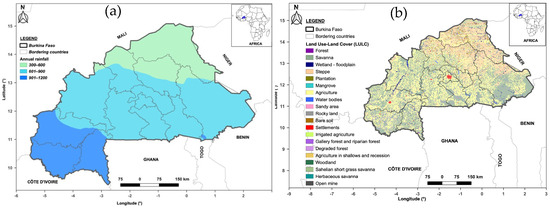
Figure 1.
Annual rainfall distribution (average of 1981–2010) in the study area is depicted in section (a), and the Land Use, Land Cover (LULC) for the year 2013 in Burkina Faso is shown in section (b). The agricultural zone is highlighted in yellow, with the highest density located in the southwest of Burkina Faso. Rainfall data from the rain gages network have been provided by the National Meteorological Agency in Burkina Faso, while the LULC data were obtained from CILSS, 2016 [21]. Quantum GIS (QGIS) version 3.22, available at https://www.qgis.org/ (accessed on 10 March 2024), was used for the creation of the study area and LULC map.
2.2. Climate Projection Data
In this study, a 0.25 degree spatial resolution of downscaled historical and future projections from the NASA Earth Exchange Global Daily Downscaled Projections (NEX-GDDP-CMIP6) has been used (accessed on 5 September 2023) [24]. The retrieved climate variables cover the period 1985–2075 and include daily precipitation, minimum and maximum near-surface air temperature, near-surface relative humidity, surface wind speed, and surface downwelling shortwave radiation. The data are based on the SSP2-4.5 (SSP245) and SSP5-8.5 (SSP585) emission scenarios, which outline a variety of possible socioeconomic futures in the Shared Socioeconomic Pathways (SSPs) [25,26]. These SSPs describe a full range of forcing targets similar to the Representative Concentration Pathways (RCPs) used in the Coupled Model Intercomparison Project Phase 5 (CMIP5). The SSP245 scenario represents a continuation of current trends without major deviations towards sustainability or fossil fuel-intensive development and is based on a forcing level of 4.5 W m−2, whereas SSP585 describes strong economic growth with a sustained use of fossil fuel and is based on a forcing level of 8.5 W m−2.
A total of 15 Global Climate Models (GCMs) have been retained based on the availability of variables in historical, RCP245, and RCP585 datasets necessary to compute evapotranspiration (ET) for the considered period (Table 1). Data processing, as well as statistical and spatial analysis, has been performed using R software available at https://www.r-project.org (accessed on 25 March 2024) in conjunction with the R packages “tidyverse” and “raster”.

Table 1.
RCMs and emissions pathways used in this study.
Evapotranspiration (ET) is key variable in the study, since it is a key input for crop–water balance and is therefore a critical component for crop growth and development. Hence, the retrieved minimum and maximum near-surface air temperature, near-surface relative humidity, surface wind speed, and surface downwelling shortwave radiation have been used in combination with grid cell coordinates and Digital Elevation Model Data (https://srtm.csi.cgiar.org/srtmdata, accessed on 27 March 2024) to compute ET based on the reference evapotranspiration (ET0, using the FAO Penman–Monteith Equation (Equation (1)), following the step-by-step instructions provided in FAO-56 [27]:
where Rn is the net radiation flux density on the crop surface (MJ m−2 d−1); G is the soil heat flux density (MJ m−2 d−1); T is the average daily air temperature (°C); u2 is the wind speed at 2 m high (m s−1); es is the saturation vapor pressure (kPa); ea is the actual vapor pressure (kPa); Δ is the slope of the vapor pressure–temperature curve (kPa °C−1) and γ is the psychometric constant (kPa °C−1).
We implemented these calculations in an R script, following the step-by-step instructions provided in FAO-56. This approach ensures consistency with established methodologies and allows for reproducibility.
2.3. Soil and Crop Data
Detailed soil information in crop models is essential for an accurate yield simulation and effective agricultural management. Soil properties such as texture and organic matter content determine the soil’s water-holding capacity, which affects the availability of water to crops. In this study, soil information encompassing organic carbon and the fractions of clay, silt, and sand were retrieved from the latest version (2.0) of the Harmonized World Soil Database (HWSD) [28]. The dataset consists of raster files with a spatial resolution of 30 arc-seconds. Six soil layers have been considered in HWSD v2.0 for maize’s maximum rooting depth (accessed on 20 December 2023). The first five layers are 20 cm deep each, while the sixth layer is 50 cm deep, corresponding to a total of 1.5 m depth. These data are further used to compute the dominant soil texture for each grid cell of 25 × 25 km resolution in the study area, based on the USDA soil classification. From a total of 625 soil textures within each grid cell, the texture corresponding to the statistical mode of the dataset has been considered the dominant soil texture. To compute the soil hydraulic characteristics for each soil layer, the dominant soil texture for each layer is linked to the soil hydraulic properties table developed by the FAO and implemented in AquaCrop. This table provides pre-calculated values for the upper limit of volumetric water-holding capacity (FC), the lower limit of water-holding capacity (PWD), the drainage coefficient (τ), and hydraulic conductivity at saturation (Ksat), which are essential for running AquaCrop [16]. Soil texture for the first soil layer (0–20 cm) is presented in Figure 2a.
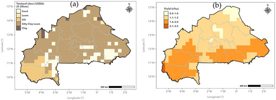
Figure 2.
Spatial distribution of soil texture (a) for the first layer and maize average yield (b) in BF.
Observed crop yield data are used to fine-tune crop parameters through the process of calibration, ensuring they accurately represent local conditions and crop responses [23]. We obtained maize crop production and cultivated areas from the Direction Générale des Etudes et des Statistiques Sectorielles of the Burkina Faso Ministry of Agriculture, Animal Resources, and Fisheries. These data are available at the province level, covering the 45 provinces in Burkina Faso, and span the period from 2009 to 2022. More information can be accessed at https://www.agriculture.gov.bf/contact (accessed on 10 August 2024).
We performed crop yield calculations (kg/ha) at a resolution of 0.25° × 0.25°. The yield for a specific grid cell is calculated using a composite weighted average that considers all provinces that share the same grid [23]. The cultivated areas of the given provinces were used as the weights in Equation (2).
where Ygrid (kg ha−1) represents the crop yield at a grid cell location, Yprovince(i) represents the crop yield in a province i, wi represents the fraction of crop land area of province i within the grid cell, and n represents the number of provinces that share the area of the targeted grid cell. The gridded average maize yield over the period 2009–2020 is presented in Figure 2b.
2.4. Crop Planting Date Strategy
To mimic farmer strategies for planting, dynamic crop model simulations require a starting date for the simulation known as the crop planting date [29]. Farmers’ planting strategies are based on the fact that wet conditions during and a few days after the planting date are necessary to ensure crop emergence and optimal first-stage development. Indeed, the appropriate crop planting date can significantly enhance water use efficiency and farmland productivity in water-scarce areas. Therefore, the adaptation of crop planting time has been shown to significantly impact crop yields, emphasizing the strategic importance of planting decisions in agriculture.
In the Sahel region in West Africa, rainfed agriculture relies on the onset of the rainy season (ORS) as a potential planting date. In that region, crop failure and resowing might be avoided if appropriate ORSs are adopted by farmers. Among ORS approaches to derive potential planting dates, rainfall-based methods are well known in West Africa. These methods are based on threshold values of agrometeorological variables such as rainfall amount, the number of wet days, and dry spell lengths [30,31]. In this study, we apply the approach proposed by [31] to derive suitable ORS dates for crop planting. This approach applies fuzzy logic rules to agronomically sound definitions of planting dates to derive a time window for crop planting. Indeed, based on [31], we defined three fuzzy functions: (1) the cumulative rainfall amount within a 5-day span, (2) the number of rainy days within a 5-day span, and (3) the longest dry spell length in the next 30 days following the planting day. A defuzzification parameter, k, which varies between 0.1 and 1, is used to calculate suitable ORSs.
2.5. Crop Yield Simulation Based on the AquaCrop Model
AquaCrop is a model designed to simulate the yield response of various crops to water, making it particularly useful for assessing the impact of climate change on crop yield in water-limited areas. It is a process-based crop model developed by the Food and Agriculture Organization (FAO) of the United Nations and is widely used to assess agricultural productivity [32,33,34]. It is specifically designed to simulate and optimize crop production, with a particular emphasis on water management in agriculture [16]. The model considers various factors, such as climate, soil water retention characteristics, field management, and crop-specific parameters, to simulate crop growth and development. The required climate data include daily rainfall, minimum (Tn) and maximum (Tx) air temperature, reference crop evapotranspiration (ET0), and carbon dioxide concentration (CO2). Field management encompasses crop planting date, nutrient, and weed management practices through weed cover and soil fertility rates.
In this study, AquaCrop has been calibrated over the period 2009–2022 and used to simulate crop yield responses to the SSP245 and SSP585 emission scenarios for the periods 2016–2045 (H2030) and 2046–2075 (H2060). Climate data for the model calibration included gridded precipitation data [35], temperature, and ET data from the fifth generation of global climate reanalysis data from the European Centre for Medium-Range Weather Forecasts (ERA5) reanalysis dataset, available on https://cds.climate.copernicus.eu/datasets/reanalysis-era5-single-levels?tab=overview (accessed on 10 March 2024), which provides data at a spatial resolution of 0.25° × 0.25 and a temporal resolution of 1 h. The crop planting date has been computed using gridded precipitation, following [31]. AquaCrop maize is calibrated using observed maize yields through a genetic algorithm optimization (GA) approach, which is used to derive the optimum value for the key parameters in AquaCrop that need calibration, including weed cover and soil fertility rates [23,36]. GAs are heuristic methods inspired by natural evolution. They mimic key operators of natural evolution such as genetic recombination (crossover) and mutation. These algorithms encode a potential solution to a specific problem in a simple chromosome-like data structure and apply recombination and mutation operators to these structures so as to preserve critical information [31,36]. Details on the key parameters, including crop parameters and management strategies used in the process of calibration using a GA, are presented in Table 2. Further, the calibrated AquaCrop maize model is used in combination with climate datasets for selected emission scenarios to assess future maize yield responses to climate change. Figure 3 depicts the flowchart of the maize yield simulation.

Table 2.
Minimum and maximum values of crop and management key parameters in study area.
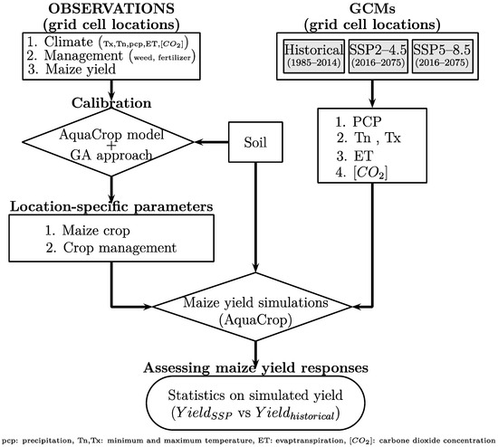
Figure 3.
Flowchart of maize yield simulation using SSP2–4.5 and SSP5–8.5 data in combination with AquaCrop model.
3. Results
3.1. Performance of Calibrated Parameters
In the process of calibration, the crop and management parameters listed in Table 2 were optimized using a GA. Two metrics, the coefficients of determination (R2) and the Relative Absolute Error (RAE), were used to analyze the performance of the calibration. The results showed an R2 ranging from 0.20 to 0.70 (Figure 4a), while the RAE ranged from 5% to 40% (Figure 4b), with a majority of locations reaching values of R2 and RAE higher (lower) than 0.41 (30%), respectively. The spatial distribution highlights a highest R2 and an RAE between 21% and 30% in the southwest of Burkina Faso, the main agricultural zone for maize cropping.
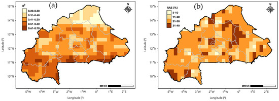
Figure 4.
Performance metrics R2 (a) and RAE (b) in the study area. Pairwise observed and simulated maize yields for the period 2009–2022 have been used to compute the R2 and RAE for each grid cell across BF.
3.2. Climate Projection Across BF
3.2.1. Precipitation Changes
Changes in precipitation are calculated by comparing annual precipitation projections from the Shared Socioeconomic Pathways (SSPs) to historical data, both derived from GCMs. The historical GCM data serve as the baseline for this comparison. Figure 5 shows the average of and variability in precipitation changes for the ensemble of 15 GCMs. The statistics are based on the scenarios SSP245 and SSP585 for the time horizons 2016–2045 (H2030) and 2046–2075 (H2060). Overall, precipitation is expected to change by −20% to 20% on average, with a standard deviation varying from 10% to 50% across BF. SSP245, as well as SSP585, reveals for H2030 and H2060 an expected decrease in precipitation for the southern half of BF, including the Southwestern BF, the main agricultural production zone for H2030 and H2060. However, for H2060, an increase (less than 20%) is expected for SSP585 for the northern half of BF. A north–south gradient is observed for the variability in precipitation changes, with the highest variability in the Northern BF (annual precipitation less than 600 mm) and the lowest variability in the Southern BF (annual precipitation greater than 900 mm).
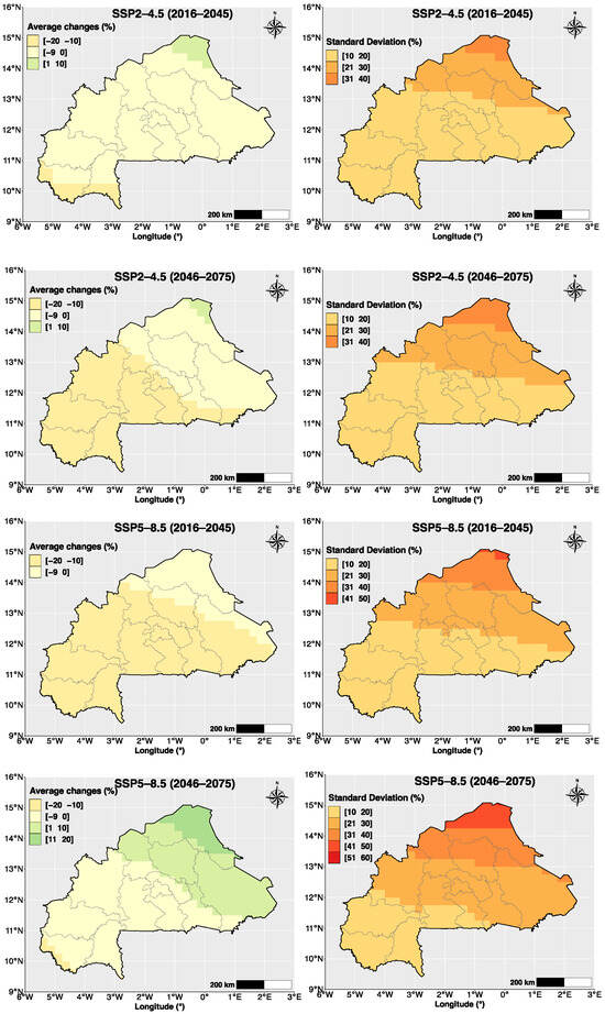
Figure 5.
Ensemble mean (left) and standard deviation (right) of precipitation. Statistics are calculated based on projected annual precipitation changes from 15 GCMs.
3.2.2. Temperature Changes
The mean temperature calculated from the ensemble of 15 GCMs is expected to increase by 0.5 °C to 2 °C and 1 °C to 3 °C for SSP245 and SSP585, respectively, in BF (Figure 6). The lowest increase is expected for SSP245 and H2030, while the highest increases are expected for SSP585 and H2060. For scenario SSP585, the Northern BF is expected to be more affected by a higher increase in mean temperature. The variability in temperature changes ranges from 1 °C to 2 °C across BF, with the highest variability found for SSP585. However, the spatial distribution of this variability reveals higher values (greater than 1.5 °C) in areas located between the isohyets of 600 mm and 900 mm in BF.
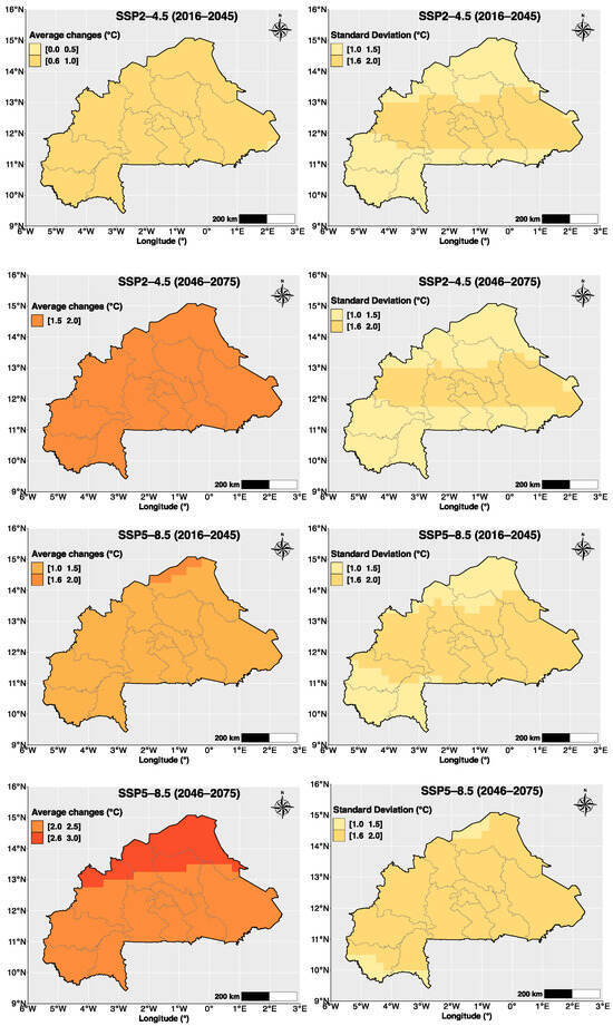
Figure 6.
Ensemble mean (left) and standard deviation (right) of temperature. Statistics are calculated based on projected annual mean temperature changes from 15 GCMs.
3.3. Spatial Pattern of Maize Mean Yield Changes in the Future
Figure 7 presents the expected changes in maize yield for the scenarios SSP245 and SSP585, considering the time horizons H2030 and H2060. At the grid-cell level, statistics are based on the relative difference between simulated yields for the future (H2030 or H2060) and the control period (1986–2015) for each of the 15 GCMs. The results show that yield changes range from −40% to 20%, with a dominant decrease in yield across BF, particularly for H2060. The emission scenario SSP245 reveals a lesser magnitude of decrease in maize yield compared to SSP585. The spatial pattern of yield changes indicates that the Southwestern BF will be more affected, with a higher yield decrease of more than 10% for SSP245 and more than 20% for SSP585.
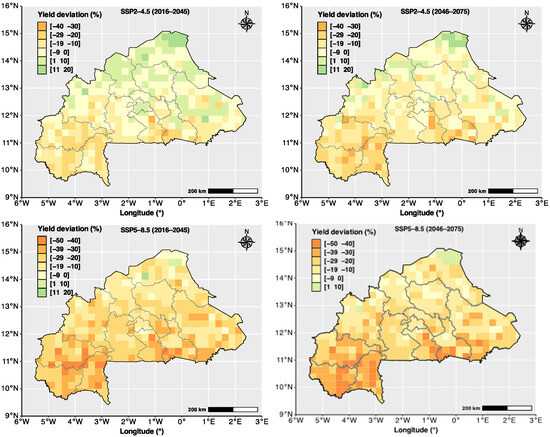
Figure 7.
Projected maize yield changes for emission scenarios SSP2–4.5 (top) and SSP5–8.5 (bottom). For each grid cell, the yield deviation represents the ensemble mean from the 15 GCMs.
3.4. Variability in Maize Mean Yield Changes in the Future
For each GCM, we investigate the variability in yield change for SSP245 and SSP585 over the two periods, i.e., H2030 and H2060. As a result, Figure 8 shows that a high frequency (greater than 75%) in the annual yield deviation is negative, regardless of the considered time horizon and GCM. However, regarding the magnitude of variability in maize yield deviation, higher values are observed for SSP245 (under H2060) and for SSP585 (under H2030). Among the GCMs, yield deviation based on SSP585 is found to be more variable for ACCESS-CM2, ACCESS-ESM1-5, and NorESM2-LM, regardless of the time horizon. For SSP245, all GCMs reveal that yield deviation is more variable for H2060 compared to H2030.
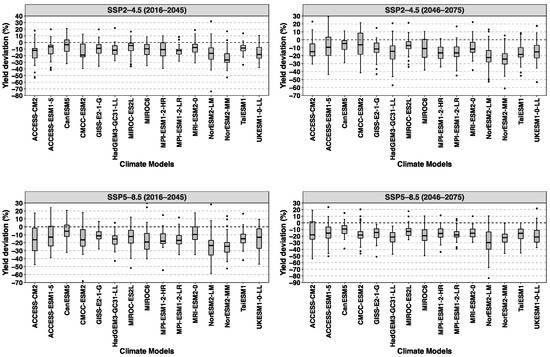
Figure 8.
Maize yield deviation [%] through GCMs in BF. For each GCM, all grid cells within BF are considered to compute the statistics.
4. Discussion
The climate projections and maize yield simulations presented in this study provide a comprehensive analysis of how climate change might affect maize yields in Burkina Faso, using the latest climate change projection data and crop simulation approach associated with the AquaCrop model. The projections from CMIP6 under the SSP2-4.5 and SSP5-8.5 scenarios indicate substantial changes in both temperature and precipitation patterns across Burkina Faso. They reveal a complex pattern of changes in precipitation and temperature across the country. The projected decrease in precipitation for the southern half of the country, including the key agricultural zone in the southwest, is particularly concerning. In addition, the northern part of Burkina Faso, characterized by lower annual precipitation, is expected to experience higher variability, which could lead to increased uncertainty in water availability for crops. This aligns with findings from other studies in West Africa that have highlighted the vulnerability of the region to climate change [7,37,38]. The north–south gradient in precipitation variability, with higher variability in the drier north, suggests that already marginal agricultural areas may face increased uncertainty in rainfall patterns.
Regarding the mean temperature, the projected increases of 0.5–3 °C, with higher increases under the SSP5-8.5 scenario, are consistent with broader regional projections for West Africa [39,40]. The more pronounced warming in Northern Burkina Faso could exacerbate existing challenges in these semi-arid areas, potentially pushing some regions beyond the threshold for viable rainfed agriculture. For instance, an increase in mean temperatures could exacerbate heat stress on crops, particularly during critical growth stages such as flowering and grain filling. This aligns with the literature that emphasizes the vulnerability of annual crops to temperature extremes, which can significantly impair yield potential [11].
The results of yield simulations under climate change highlight the significant challenges that climate change poses to agriculture in the region, especially for rainfed crops like maize that are crucial for food security [41]. Indeed, the predominant decrease in projected maize yields across Burkina Faso, particularly under the SSP5-8.5 scenario, highlights the vulnerability of the country’s agricultural sector to climate change. The southwestern region, currently a major agricultural production zone, appears especially at risk, with projected yield decreases exceeding 20% under SSP5-8.5. This aligns with studies that have identified maize as particularly sensitive to climate change in West Africa [42,43]. The findings are also consistent with other research indicating that climate change could lead to reduced agricultural productivity in West Africa [43,44]
The high frequency of negative annual yield deviations across all GCMs underscores the robustness of the projected decline in maize productivity. However, the variability in yield projections between GCMs, particularly for ACCESS-CM2, ACCESS-ESM1-5, and NorESM2-LM under SSP5-8.5, highlights the uncertainty inherent in long-term agricultural projections. This variability emphasizes the need for adaptive strategies to mitigate these impacts, therefore responding to a range of potential future conditions such as heat stress and water scarcity. Given the projected decline in maize productivity and the associated uncertainties, policymakers should consider a multifaceted approach to agricultural adaptation. This should involve innovative farming techniques suited to changing climatic conditions, improved early warning systems to help farmers make informed decisions, and robust crop insurance programs to assist farmers in managing climate-related risks.
For maize as a staple crop in the country, the projected reduced yields could exacerbate existing challenges related to food availability and affordability. To address these challenges, it is important to adjust the planting dates associated with crop-growing periods and to adopt improved agricultural practices [23,45]. The spatial pattern of yield changes suggests that adaptation strategies may need to be regionally tailored, with a particular focus on the southwestern region, where impacts are projected to be most severe. The use of the AquaCrop model, well-suited for water-limited areas [32], is particularly useful for regions like Burkina Faso, where rainfed agriculture prevails and water scarcity is a critical concern. Moreover, the integration of socioeconomic pathways (SSPs) in the analysis allows for a more nuanced understanding of how socioeconomic factors might influence the region’s capacity to adapt to climate change [46].
While this study provides valuable insights, several limitations should be acknowledged. While AquaCrop is suited for simulating water-driven yield responses, it may not capture other stress factors effectively, such as nutrient deficiencies, pests, and diseases. This study assumes that current management practices remain constant, which may not reflect future adaptations by farmers. Additionally, the 0.25° × 0.25° resolution of climate data and crop simulations may not capture the fine-scale variability important for local decision-making. Moreover, a great deal of caution should be exercised when using process-based crop models, which are developed to operate on a field scale but are driven by coarser-scale GCMs [47]. Indeed, the uncertainties of GCMs significantly increase the biases in climate impact studies focusing on agriculture. While this study examines the impacts under SSP5-8.5 to explore potential high-end climate risks, it is important to note that the SSP5-8.5 scenario represents unlikely worst-case scenarios for exploring extreme situations [48], rather than a likely pathway. This is due to its assumptions about future fossil fuel expansion, which are increasingly considered implausible [49].
5. Conclusions
In conclusion, this study reveals significant changes in regional temperature and precipitation, with profound implications for agricultural sustainability. Projected mean temperature increases of 0.5 to 3 °C, combined with decreased precipitation in the southern half of the country, pose substantial risks to agricultural productivity. This is particularly evident in the southwestern agricultural zone, where crop yield simulations indicate significant declines in maize production, up to 40% under the SSP5-8.5 scenario. To address these climate risks, specific adaptation strategies should be implemented. Where our results show increased heat stress, the introduction of drought-resistant varieties such as improved maize cultivars offer alternatives to traditional maize. In areas experiencing precipitation decline, a cost-effective combination of field-level water management practices and organic fertilizers could optimize limited water resources. The effective implementation of these strategies requires strengthening the capacities of agricultural extension services, integrating seasonal climate forecasts into agricultural planning processes, and supporting farmers’ adoption of resilient practices. Future research should expand beyond maize to include multi-crop modeling, to better understand crop–climate interactions and explore a wider range of local adaptation options. These modeling efforts, combined with participatory research methods, will help refine strategies and build more resilient farming communities better equipped to face climate change impacts.
Author Contributions
Conceptualization, M.W.; Methodology, M.W.; Software, M.W.; Formal analysis, M.W. and P.L.; Investigation, A.C. and S.S.; Data curation, A.C.; Writing—original draft, M.W.; Writing—review and editing, M.W. and P.L.; Supervision, H.K.; Project administration, S.S. and H.K. All authors have read and agreed to the published version of the manuscript.
Funding
This work was funded by the German Federal Ministry of Education and Research (BMBF) research project CONCERT (grant number 01LG2101A) through the West African Science Center for Climate Change and Adapted Land Use (WASCAL).
Institutional Review Board Statement
Not applicable.
Informed Consent Statement
Not applicable.
Data Availability Statement
The observed maize yield and National Meteorological datasets mentioned in this article are not readily available due to national data access policies. Requests for access to the datasets should be directed to the Direction Générale des Etudes et des Statistiques Sectorielles of the Burkina Faso Ministry of Agriculture, Animal Resources, and Fisheries, as well as the National Meteorological Agency of Burkina Faso.
Acknowledgments
We would like to thank the Direction Générale des Etudes et des Statistiques Sectorielles of the Burkina Faso Ministry of Agriculture, Animal Resources, and Fisheries and the National Meteorological Agency of Burkina Faso (ANAM-BF) for providing crop yield and climate data from their survey and observation network, respectively. We also acknowledge the anonymous reviewers for their valuable comments.
Conflicts of Interest
The authors declare no conflicts of interest.
References
- Trisos, C.; Adelekan, I.; Totin, E.; Ayanlade, A.; Efitre, J.; Gemeda, A.; Kalaba, K.; Lennard, C.; Masao, C.; Mgaya, Y.; et al. Africa. In Climate Change 2022—Impacts, Adaptation and Vulnerability: Working Group II Contribution to the Sixth Assessment Report of the Intergovernmental Panel on Climate Change; Intergovernmental Panel on Climate Change (IPCC), Ed.; Cambridge University Press: Cambridge, UK, 2023; pp. 1285–1456. ISBN 978-1-00-932583-7. [Google Scholar]
- Dosio, A. Projection of Temperature and Heat Waves for Africa with an Ensemble of CORDEX Regional Climate Models. Clim. Dyn. 2017, 49, 493–519. [Google Scholar] [CrossRef]
- Dosio, A.; Jury, M.W.; Almazroui, M.; Ashfaq, M.; Diallo, I.; Engelbrecht, F.A.; Klutse, N.A.B.; Lennard, C.; Pinto, I.; Sylla, M.B.; et al. Projected Future Daily Characteristics of African Precipitation Based on Global (CMIP5, CMIP6) and Regional (CORDEX, CORDEX-CORE) Climate Models. Clim. Dyn. 2021, 57, 3135–3158. [Google Scholar] [CrossRef]
- Sylla, M.B.; Elguindi, N.; Giorgi, F.; Wisser, D. Projected Robust Shift of Climate Zones over West Africa in Response to Anthropogenic Climate Change for the Late 21st Century. Clim. Chang. 2016, 134, 241–253. [Google Scholar] [CrossRef]
- Weber, T.; Haensler, A.; Rechid, D.; Pfeifer, S.; Eggert, B.; Jacob, D. Analyzing Regional Climate Change in Africa in a 1.5, 2, and 3 °C Global Warming World. Earth’s Future 2018, 6, 643–655. [Google Scholar] [CrossRef]
- Jones, P.G.; Thornton, P.K. Croppers to Livestock Keepers: Livelihood Transitions to 2050 in Africa Due to Climate Change. Environ. Sci. Policy 2009, 12, 427–437. [Google Scholar] [CrossRef]
- Roudier, P.; Sultan, B.; Quirion, P.; Berg, A. The Impact of Future Climate Change on West African Crop Yields: What Does the Recent Literature Say? Glob. Environ. Chang. 2011, 21, 1073–1083. [Google Scholar] [CrossRef]
- Sultan, B.; Defrance, D.; Iizumi, T. Evidence of Crop Production Losses in West Africa Due to Historical Global Warming in Two Crop Models. Sci. Rep. 2019, 9, 12834. [Google Scholar] [CrossRef]
- Zhao, C.; Liu, B.; Piao, S.; Wang, X.; Lobell, D.B.; Huang, Y.; Huang, M.; Yao, Y.; Bassu, S.; Ciais, P.; et al. Temperature Increase Reduces Global Yields of Major Crops in Four Independent Estimates. Proc. Natl. Acad. Sci. USA 2017, 114, 9326–9331. [Google Scholar] [CrossRef]
- Betts, A.R. Integrated Approaches to Climate–Crop Modelling: Needs and Challenges. Philos. Trans. R. Soc. B Biol. Sci. 2005, 360, 2049–2065. [Google Scholar] [CrossRef]
- Schlenker, W.; Lobell, D.B. Robust Negative Impacts of Climate Change on African Agriculture. Environ. Res. Lett. 2010, 5, 014010. [Google Scholar] [CrossRef]
- Rosenzweig, C.; Jones, J.W.; Hatfield, J.L.; Ruane, A.C.; Boote, K.J.; Thorburn, P.; Antle, J.M.; Nelson, G.C.; Porter, C.; Janssen, S.; et al. The Agricultural Model Intercomparison and Improvement Project (AgMIP): Protocols and Pilot Studies. Agric. For. Meteorol. 2013, 170, 166–182. [Google Scholar] [CrossRef]
- Niyogi, D.; Liu, X.; Andresen, J.; Song, Y.; Jain, A.K.; Kellner, O.; Takle, E.S.; Doering, O.C. Crop Models Capture the Impacts of Climate Variability on Corn Yield. Geophys. Res. Lett. 2015, 42, 3356–3363. [Google Scholar] [CrossRef]
- Tao, F.; Palosuo, T.; Rötter, R.P.; Díaz-Ambrona, C.G.H.; Inés Mínguez, M.; Semenov, M.A.; Kersebaum, K.C.; Cammarano, D.; Specka, X.; Nendel, C.; et al. Why Do Crop Models Diverge Substantially in Climate Impact Projections? A Comprehensive Analysis Based on Eight Barley Crop Models. Agric. For. Meteorol. 2020, 281, 107851. [Google Scholar] [CrossRef]
- Hoogenboom, G. Contribution of Agrometeorology to the Simulation of Crop Production and Its Applications. Agric. For. Meteorol. 2000, 103, 137–157. [Google Scholar] [CrossRef]
- Steduto, P.; Hsiao, T.C.; Raes, D.; Fereres, E. AquaCrop—The FAO Crop Model to Simulate Yield Response to Water: I. Concepts Underlying Principles. Agron. J. 2009, 101, 426–437. [Google Scholar] [CrossRef]
- Keating, B.A.; Carberry, P.S.; Hammer, G.L.; Probert, M.E.; Robertson, M.J.; Holzworth, D.; Huth, N.I.; Hargreaves, J.N.G.; Meinke, H.; Hochman, Z.; et al. An Overview of APSIM, a Model Designed for Farming Systems Simulation. Eur. J. Agron. 2003, 18, 267–288. [Google Scholar] [CrossRef]
- Gidden, M.J.; Riahi, K.; Smith, S.J.; Fujimori, S.; Luderer, G.; Kriegler, E.; van Vuuren, D.P.; van den Berg, M.; Feng, L.; Klein, D.; et al. Global Emissions Pathways under Different Socioeconomic Scenarios for Use in CMIP6: A Dataset of Harmonized Emissions Trajectories through the End of the Century. Geosci. Model Dev. 2019, 12, 1443–1475. [Google Scholar] [CrossRef]
- Sivakumar, M.V.K.; Gnoumou, F. Agroclimatology of West Africa: Burkina Faso. Available online: https://oar.icrisat.org/864/ (accessed on 5 August 2024).
- Zidouemba, P. Economy-Wide Implications of Climate Change in Burkina Faso. Econ. Bull. 2017, 37, 2797–2808. [Google Scholar]
- Tappan, G.G.; Cushing, W.M.; Cotillon, S.E.; Hutchinson, J.A.; Pengra, B.; Alfari, I.; Botoni, E.; Soulé, A.; Herrmann, S.M. Landscapes of West Africa: A Window on a Changing World; United States Geological Survey: Garretson, SD, USA, 2016; pp. 82–89. [CrossRef]
- Diao, X.; Hazell, P.B.; Danielle, R.; James, T. The Role of Agriculture in Development: Implications for Sub-Saharan Africa; International Food Policy Research Institute: Washington, DC, USA, 2007; ISBN 978-0-89629-161-4. [Google Scholar]
- Waongo, M.; Laux, P.; Kunstmann, H. Adaptation to Climate Change: The Impacts of Optimized Planting Dates on Attainable Maize Yields under Rainfed Conditions in Burkina Faso. Agric. For. Meteorol. 2015, 205, 23–39. [Google Scholar] [CrossRef]
- Thrasher, B.; Wang, W.; Michaelis, A.; Melton, F.; Lee, T.; Nemani, R. NASA Global Daily Downscaled Projections, CMIP6. Sci. Data 2022, 9, 262. [Google Scholar] [CrossRef]
- O’Neill, B.C.; Tebaldi, C.; van Vuuren, D.P.; Eyring, V.; Friedlingstein, P.; Hurtt, G.; Knutti, R.; Kriegler, E.; Lamarque, J.-F.; Lowe, J.; et al. The Scenario Model Intercomparison Project (ScenarioMIP) for CMIP6. Geosci. Model Dev. 2016, 9, 3461–3482. [Google Scholar] [CrossRef]
- Wyser, K.; Kjellström, E.; Koenigk, T.; Martins, H.; Döscher, R. Warmer Climate Projections in EC-Earth3-Veg: The Role of Changes in the Greenhouse Gas Concentrations from CMIP5 to CMIP6. Environ. Res. Lett. 2020, 15, 054020. [Google Scholar] [CrossRef]
- Allen, R.G.; Pereira, L.S.; Raes, D.; Smith, M. Crop Evapotranspiration—Guidelines for Computing Crop Water Requirements—FAO Irrigation and Drainage Paper 56; Food and Agriculture Organization: Rome, Italy, 1998. [Google Scholar]
- FAO. IIASA Harmonized World Soil Database Version 2.0; FAO, International Institute for Applied Systems Analysis (IIASA): Rome, Italy, 2023; ISBN 978-92-5-137499-3. [Google Scholar]
- Sacks, W.J.; Deryng, D.; Foley, J.A.; Ramankutty, N. Crop Planting Dates: An Analysis of Global Patterns. Glob. Ecol. Biogeogr. 2010, 19, 607–620. [Google Scholar] [CrossRef]
- Laux, P.; Kunstmann, H.; Bárdossy, A. Predicting the Regional Onset of the Rainy Season in West Africa. Int. J. Climatol. 2008, 28, 329–342. [Google Scholar] [CrossRef]
- Waongo, M.; Laux, P.; Traoré, S.B.; Sanon, M.; Kunstmann, H. A Crop Model and Fuzzy Rule Based Approach for Optimizing Maize Planting Dates in Burkina Faso, West Africa. J. Appl. Meteorol. Climatol. 2014, 53, 598–613. [Google Scholar] [CrossRef]
- Raes, D.; Steduto, P.; Hsiao, T.C.; Fereres, E. AquaCrop—The FAO Crop Model to Simulate Yield Response to Water: II. Main Algorithms and Software Description. Agron. J. 2009, 101, 438–447. [Google Scholar] [CrossRef]
- Abedinpour, M.; Sarangi, A.; Rajput, T.B.S.; Singh, M.; Pathak, H.; Ahmad, T. Performance Evaluation of AquaCrop Model for Maize Crop in a Semi-Arid Environment. Agric. Water Manag. 2012, 110, 55–66. [Google Scholar] [CrossRef]
- Foster, T.; Brozović, N.; Butler, A.P.; Neale, C.M.U.; Raes, D.; Steduto, P.; Fereres, E.; Hsiao, T.C. AquaCrop-OS: An Open Source Version of FAO’s Crop Water Productivity Model. Agric. Water Manag. 2017, 181, 18–22. [Google Scholar] [CrossRef]
- Garba, J.N.; Diasso, U.J.; Waongo, M.; Sawadogo, W.; Daho, T. Performance Evaluation of Satellite-Based Rainfall Estimation across Climatic Zones in Burkina Faso. Theor. Appl. Climatol. 2023, 154, 1051–1073. [Google Scholar] [CrossRef]
- Scrucca, L. GA: A Package for Genetic Algorithms in R. J. Stat. Softw. 2013, 53, 1–37. [Google Scholar] [CrossRef]
- Sorgho, R.; Quiñonez, C.A.M.; Louis, V.R.; Winkler, V.; Dambach, P.; Sauerborn, R.; Horstick, O. Climate Change Policies in 16 West African Countries: A Systematic Review of Adaptation with a Focus on Agriculture, Food Security, and Nutrition. Int. J. Environ. Res. Public Health 2020, 17, 8897. [Google Scholar] [CrossRef] [PubMed]
- Mertz, O.; Mbow, C.; Reenberg, A.; Genesio, L.; Lambin, E.F.; D’haen, S.; Zorom, M.; Rasmussen, K.; Diallo, D.; Barbier, B.; et al. Adaptation Strategies and Climate Vulnerability in the Sudano-Sahelian Region of West Africa. Atmos. Sci. Lett. 2011, 12, 104–108. [Google Scholar] [CrossRef]
- Almazroui, M.; Saeed, F.; Saeed, S.; Nazrul Islam, M.; Ismail, M.; Klutse, N.A.B.; Siddiqui, M.H. Projected Change in Temperature and Precipitation Over Africa from CMIP6. Earth Syst. Environ. 2020, 4, 455–475. [Google Scholar] [CrossRef]
- Ayugi, B.O.; Chung, E.-S.; Zhu, H.; Ogega, O.M.; Babousmail, H.; Ongoma, V. Projected Changes in Extreme Climate Events over Africa under 1.5 °C, 2.0 °C and 3.0 °C Global Warming Levels Based on CMIP6 Projections. Atmos. Res. 2023, 292, 106872. [Google Scholar] [CrossRef]
- Egbebiyi, T.S.; Crespo, O.; Lennard, C. Defining Crop–Climate Departure in West Africa: Improved Understanding of the Timing of Future Changes in Crop Suitability. Climate 2019, 7, 101. [Google Scholar] [CrossRef]
- Muluneh, A. Impact of Climate Change on Soil Water Balance, Maize Production, and Potential Adaptation Measures in the Rift Valley Drylands of Ethiopia. J. Arid. Environ. 2020, 179, 104195. [Google Scholar] [CrossRef]
- Jones, P.G.; Thornton, P.K. The Potential Impacts of Climate Change on Maize Production in Africa and Latin America in 2055. Glob. Environ. Chang. 2003, 13, 51–59. [Google Scholar] [CrossRef]
- Mechiche-Alami, A.; Abdi, A.M. Agricultural Productivity in Relation to Climate and Cropland Management in West Africa. Sci. Rep. 2020, 10, 3393. [Google Scholar] [CrossRef]
- Abbas, G.; Younis, H.; Naz, S.; Fatima, Z.; Atique-ur-Rehman; Hussain, S.; Ahmed, M.; Ahmad, S. Effect of Planting Dates on Agronomic Crop Production. In Agronomic Crops: Volume 1: Production Technologies; Hasanuzzaman, M., Ed.; Springer: Singapore, 2019; pp. 131–147. ISBN 978-981-329-151-5. [Google Scholar]
- van Vuuren, D.P.; Riahi, K.; Calvin, K.; Dellink, R.; Emmerling, J.; Fujimori, S.; Kc, S.; Kriegler, E.; O’Neill, B. The Shared Socio-Economic Pathways: Trajectories for Human Development and Global Environmental Change. Glob. Environ. Chang. 2017, 42, 148–152. [Google Scholar] [CrossRef]
- Laux, P.; Rötter, R.P.; Webber, H.; Dieng, D.; Rahimi, J.; Wei, J.; Faye, B.; Srivastava, A.K.; Bliefernicht, J.; Adeyeri, O.; et al. To Bias Correct or Not to Bias Correct? An Agricultural Impact Modelers’ Perspective on Regional Climate Model Data. Agric. For. Meteorol. 2021, 304–305, 108406. [Google Scholar] [CrossRef]
- Cao, W.; Duan, C.; Yang, T.; Wang, S. Higher Heat Stress Increases the Negative Impact on Rice Production in South China: A New Perspective on Agricultural Weather Index Insurance. Atmosphere 2022, 13, 1768. [Google Scholar] [CrossRef]
- Vujadinović Mandić, M.; Vuković Vimić, A.; Fotirić Akšić, M.; Meland, M. Climate Potential for Apple Growing in Norway—Part 2: Assessment of Suitability of Heat Conditions under Future Climate Change. Atmosphere 2023, 14, 937. [Google Scholar] [CrossRef]
Disclaimer/Publisher’s Note: The statements, opinions and data contained in all publications are solely those of the individual author(s) and contributor(s) and not of MDPI and/or the editor(s). MDPI and/or the editor(s) disclaim responsibility for any injury to people or property resulting from any ideas, methods, instructions or products referred to in the content. |
© 2024 by the authors. Licensee MDPI, Basel, Switzerland. This article is an open access article distributed under the terms and conditions of the Creative Commons Attribution (CC BY) license (https://creativecommons.org/licenses/by/4.0/).