Article

Characterization of the Major Elements and Paleoenvironmental Significance of the Shiyang Profile in the Weinan Basin, China

by
Jing Cao
1,2,3,
Qiuyao Dong
1,2,
Chengxiang Li
3,
Pan Wang
1,2,
Zhenjing Yang
1,2 and
Hongyun Chen
1,2,*
1
Institute of Hydrogeology and Environmental Geology, Chinese Academy of Geological Sciences, Shijiazhuang 050061, China
2
Key Laboratory of Quaternary Chronology and Environment Evolution, China Geological Survey, Shijiazhuang 050061, China
3
College of Earth and Planetary Sciences, Chengdu University of Technology, Chengdu 610059, China
*
Author to whom correspondence should be addressed.
Atmosphere 2024, 15(10), 1227; https://doi.org/10.3390/atmos15101227
Submission received: 23 August 2024 / Revised: 7 October 2024 / Accepted: 11 October 2024 / Published: 14 October 2024

Abstract

:
The enrichment and migration patterns of different chemical elements record paleoclimatic information in loess formations. The chemical elemental measurements of 245 samples from the Shiyang profile in the Weinan Region were compared with the geochemical characteristics of typical wind-formed profiles, and the paleoclimatic evolution was discussed. The results showed the following: (1) the standardized curves of the cumulative concentrations of SiO2, Al2O3, and CaO along with the Upper Continental Crust (UCC) in the Shiyang profile exhibited significant similarities with typical wind-formed profiles. This strongly suggests that the Shiyang profile has a wind-formed origin. (2) The mean value of the chemical index of alteration (CIA) of the Shiyang profile is 62.06, indicating that the Shiyang profile has been in the stage of primary chemical weathering. (3) The ratios of K2O/Al2O3, TiO2/Al2O3, and Fe2O3/Al2O3 in the Shiyang profile are comparable to those found in typical wind-formed profiles, suggesting a common source area and supporting the premise that the Shiyang profile is of wind-induced origin.(4) The regional climate has undergone a series of transitions: from a dry and cool phase in the early Holocene to warm and humid yet unstable conditions in the middle Holocene, and returning to dry and cool during the late Holocene.

Graphical Abstract

1. Introduction

The loess sequence of the Loess Plateau in China, as the most complete and continuous record of wind-formed sediments preserved globally, provides valuable information for the study of the Earth’s paleoclimate and paleoenvironmental evolution [1,2]. A notable environmental feature of the Holocene is the experience of multiple alternating ice ages and interglacial periods [3,4], which led to the expansion and contraction of glaciers on Earth and, in turn, had an impact on the climate and environment on a global scale [5]. As a representative geological carrier, loess contains a large number of dust particles. The grain size [6,7,8], magnetic susceptibility [9,10,11], geochemistry [12]. ref., and other indicators can respond to climate changes, reflecting the alternating changes in global glacial and interglacial climates since the Quaternary period. Geochemical indicators are highly sensitive indicators that reflect regional environmental changes and are reliable for revealing regional climate changes and global climate evolution [13,14]. Among them, changes in the content of chemical indicators that are indicative of climate play an important role in sediment source tracing [15], paleoclimate reconstruction [16], and the determination of the degree of weathering of wind-formed loess [17]. Some scholars have conducted research on certain profiles of the Loess Plateau while focusing on constant elements. For instance, researchers have studied the loess profiles in the transitional zone between the northern Loess Plateau and the Mu Us Desert. Due to the heterogeneity of the geochemical components in the sediments, they employed various geochemical indicators, such as the CIA value, to conduct comparative analyses and interpret the changes in weathering intensity and paleoclimate information recorded in the loess and paleosols [18]. Additionally, studies have been carried out on the constant elements in a Holocene loess profile in Zhuanglang County, located in the southwestern part of the Loess Plateau, revealing the degree of elemental migration and climate fluctuations during the Holocene [19]. Furthermore, high-resolution research has been conducted on the Songcungou profile in the Linfen Basin, at the southeastern edge of the Loess Plateau, where scholars analyzed the chemical weathering intensity, climate evolution, and driving mechanisms of the loess-paleosol sequences [20].The Shiyang profile is located in Pucheng County, Weinan City, at the southern edge of the typical Loess Plateau, in the zone of interaction between the East Asian summer wind and the winter wind [21], where deep wind-dust deposits are developed. The study of environmental evolution in the region is a vital probe for the development of climate evolution in the Weinan Basin [22,23]. Furthermore, comprehensive investigations of high-resolution paleoclimate records in the Weinan Region that utilize a combination of geochemical indicators remain relatively scarce. Therefore, this study focuses on the loess-paleosol stratigraphy of the Shiyang profile as the primary research carrier and analyzes the compositional characteristics of major elements within this profile. It also explores the differences in dust sources and chemical weathering intensity by comparing the major elements’ data with those from other typical wind-formed profiles. In addition, the study also investigated the intensity of chemical weathering recorded in the Shiyang profile using CIA, Na/K, and A-CN-K. At the same time, climate proxies such as grain size and geochemical indicators were synthesized and discussed to elucidate the information on the environmental evolution contained in the Shiyang profile to provide evidence for an in-depth understanding of climate change in the Weinan Basin.

2. Materials and Methods

2.1. Study Area

The Weihe Basin is situated in the eastern part of the Guanzhong Basin, at the southeastern edge of the Loess Plateau (Figure 1). It has a narrow, elongated shape, extending approximately 600 km from east to west and 20 to 80 km from north to south. The basin is bordered by the Loess Plateau and the Qinling Mountains. Influenced by the Qinling uplift and the Weibei uplift [23], the Weihe River, a major tributary of the Yellow River, flows through the area, resulting in a topography characterized by higher elevations in the north and center and lower elevations in the south, with openings to the east and west. The climate of the basin is classified as temperate continental [24], and it is heavily influenced by monsoon winds, resulting in cold, dry winters and warm, humid summers [25]. The average annual precipitation ranges from 500 to 700 mm. The Shiyang profile (34°59′17.70″ N, 109°48′44.29″ E) is located in the southeastern part of the Weihe Basin on the Luohe River terrace and represents a typical loess plateau within a loess sedimentation area.

2.2. Sample Collection

A total of 245 samples were collected from the Shiyang profile at 2 cm intervals along the stratigraphic profile extending from the surface to the base of the outcrop. Approximately 1 kg of each sample was taken to ensure an adequate supply for replicate analyses of the multiclimatic proxies. Following natural indoor drying, about 20 g of each sample was placed in an onyx mortar and ground to a particle size of less than 200 mesh for the experimental determination of each index.

2.3. Indicator Tests

2.3.1. Grain Size Testing

The specific method of particle size testing in this study involved weighing 0.3–0.5 g of loess samples into a beaker (red clay or finer particles need to be reduced); adding 15 mL of 10% hydrogen peroxide and leaving it for more than 12 h to remove the organic matter in the samples; after that, the samples were stirred well, put on a hot plate, and heated up until the organic matter was completely reacted. Then, 15 mL of 10% hydrochloric acid was added to remove carbonate from the samples until the chemical reaction stopped; the treated samples were filled with pure water and left to stand for 12 h, and the upper clear liquid was poured off. Then, 10 mL of 10% hexametaphosphate dispersant was added and put into an ultrasonic oscillator for 8 min to cause the sample particles to become fully dispersed; finally, the sample was tested with a UK Mastersizer2000 laser particle sizer (Malvern Panalytical, Malvern, UK) [26].

2.3.2. Magnetic Susceptibility Testing

In this study, the magnetic susceptibility was measured using an MS2 magnetic susceptibility meter produced by Bartington Company in the Witney, UK. After drying all of the samples, they were ground into powder without damaging the natural particles. The samples were placed in a non-magnetic cylindrical polyethylene box and weighed after the internal pressure was uniform. A low-frequency magnetic susceptibility test was performed on each sample, and the average value of each sample was measured three times [27].

2.3.3. Major Geochemical Element Testing

In this study, the major elements were determined using the PW2403 X-Ray fluorescence spectrometer produced by the Dutch company Panalytical (Almelo, The Netherlands). Firstly, the samples were dried, and 5 g of the samples were ground to less than 200 mesh with an agate mortar. Boric acid was used as an auxiliary, pressed into pieces, and measured. The measurement error was less than 10%.
The testing of the grain size, magnetic susceptibility, and major chemical elements for this study was conducted at the Institute of Hydrogeology and Environmental Geology, Chinese Academy of Geological Sciences.

3. Results

3.1. Establishment of Loess-Paleosol Sequences in the Shiyang Profile

This study compares the stratigraphy of the Shiyang profile with that of the Holocene profiles at Laoguantai [28] and Jiangyangcun [29]. All three profiles are situated in the Weinan Basin, sharing a nearly identical geographic environment. Despite variations in thickness, the structural characteristics of the strata are similar, indicating a high degree of comparability between the Shiyang profile and the other two profiles(Figure 2). Table 1 describes the stratigraphic characteristics of the Shiyang profile.
Based on previous research findings regarding the age of the wind-formed loess-paleosol sequence in the Laoguantai and Jiangyangcun profiles [28,29], the following age boundaries were established for the Shiyang profile: the age boundary between the Malan loess layer ( L 1 ) and the early Holocene transitional loess layer ( L t ) is 11,500 a BP; the age boundary between the early Holocene transitional loess layer ( L t ) and the paleosol layer ( S 0 2 ) is 8500 a BP; the age boundary between the top of the paleosol layer ( S 0 1 ) and the mid-Holocene transitional loess layer ( L x ) is 6000 a BP; the age of the top boundary of Lx is 5000 a BP; the age of the top boundary of the mid-Holocene paleosol layer ( S 0 ) is 3100 a BP.

3.2. Characterization of the Composition of the Macronutrients

Table 2 presents the concentrations of major elements in the Shiyang loess, Shiyang paleosol, Luochuan loess, Luochuan paleosol, Zhenjiang Xiashu loess, Xifeng red clay, Xuancheng aeolian rea earth, PAAS, and the UCC. As indicated in Table 2, the major elements in the loess of the Shiyang profile are SiO2, Al2O3, CaO, and Fe2O3, with average contents of 55%, 12%, 10%, and 3%, respectively, resulting in a total average content of 80%. In the paleosol, the average CaO content is 6%, which is lower than that in the loess, but the major elements remain SiO2, Al2O3, CaO, and Fe2O3, with average contents of 60%, 13%, 6%, and 4%, respectively, yielding a total average content of 83%. CaO in the loess exists primarily as calcium carbonate, which is leached under warm and humid conditions; conversely, under relatively dry and cold conditions, calcium carbonate is formed and becomes relatively enriched. Therefore, the difference in CaO content between loess and paleosol in a profile is likely to be influenced by changes in the climatic background at that time. Furthermore, a comparison of the average chemical compositions of macronutrients in Shiyang loess and Shiyang paleosol and typical wind-formed deposits from various regions reveals that the chemical compositions of Shiyang paleosol and loess are similar to those of these typical wind-formed sediments. The sums of the major chemical components, such as SiO₂, Al₂O₃, and Fe₂O₃, are comparable to those found in typical wind-formed sediments, suggesting that the Shiyang profile has a wind-formed genesis.
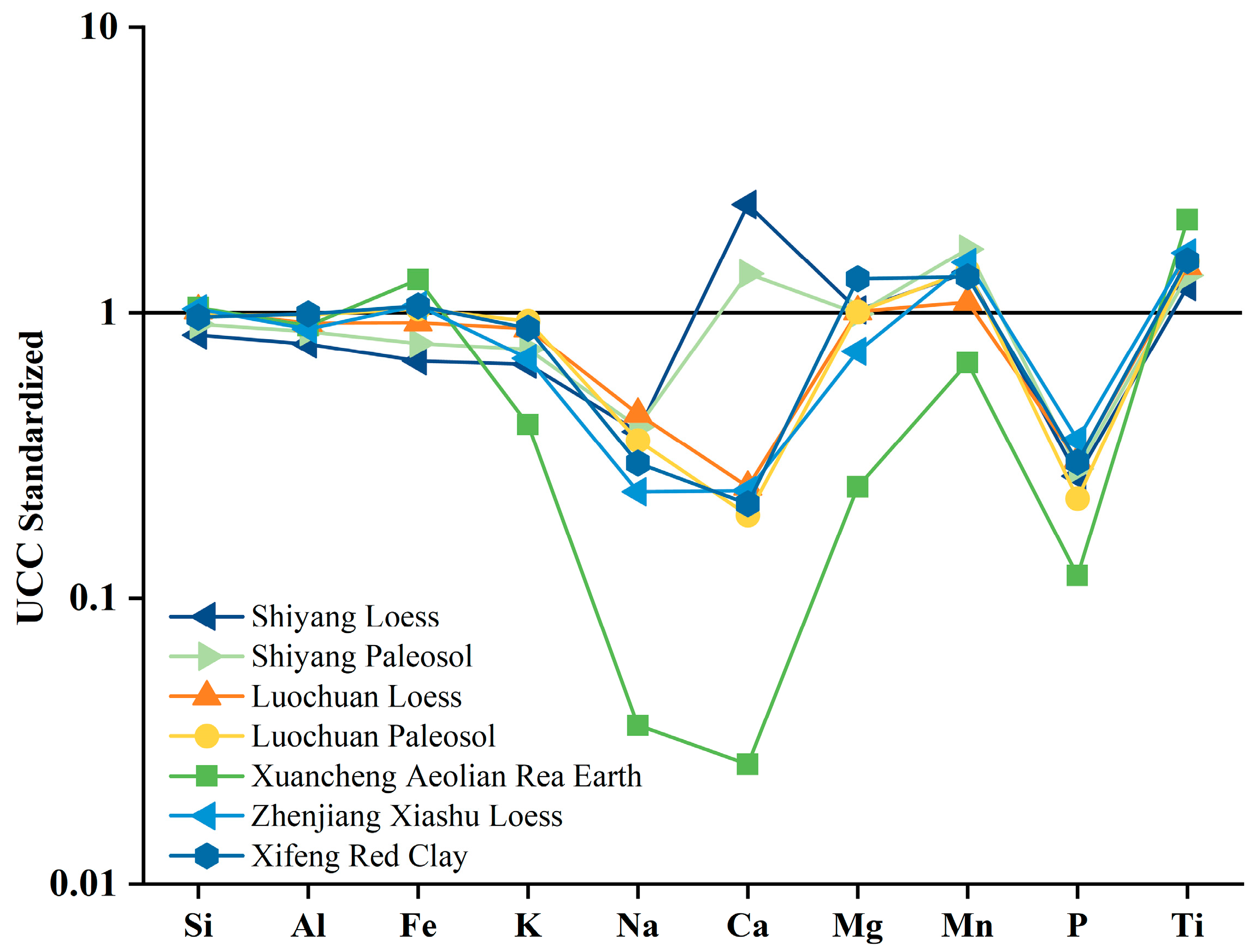
The chemical composition of wind-formed sediments that have undergone multiple transport and accumulation processes before deposition generally aligns with the UCC composition [35]. Figure 3 shows the distribution of the UCC standardized curves for the Shiyang profile and other wind-formed sediments(Figure 3). The figure reveals that Na and P elements in the loess and paleosols of Shiyang exhibit notable depletion compared with the UCC, while Ca shows significant enrichment. However, the distribution curves for most major elements closely resemble those of the UCC, appearing relatively flat and linear for Si, Al, Fe, K, Mg, Mn, and Ti. This suggests that the loess and paleosol in Shiyang are derived from the UCC and were thoroughly mixed during their prolonged formation. The depletion of Na and P is likely attributable to continental chemical weathering. A comparison of the UCC standardization results for the major elements of the Shiyang profile with those of other typical wind-formed sediments indicates a strong similarity, further confirming that the loess and paleosol of the Shiyang profile have a wind-formed origin.
It should be especially emphasized that different regions are not exactly similar to the same extent due to the differences in climatic backgrounds of their geological historical periods, resulting in wind-formed sediments [36]. As can be seen from the figure, the Shiyang paleosol and loess are very similar to the UCC standardized curves of the Luochuan paleosol, Luochuan loess, Zhenjiang Xiashu loess, and Xifeng red clay, but are less similar to Xuancheng aeolian rea earth. Compared with the UCC curves, the values of Si, Al, Fe, and other major elements in the Luochuan loess and paleosol, Xifeng red clay, Zhenjiang Xiashu loess, and Shiyang loess and paleosols after standardization are all near 1, reflecting that the sediments have gone through a relatively long transportation process before accumulation, and the compositions have tended to be homogenized, which then indicates that the loess of the Shiyang profile is mainly deposited from remote sources. Most of the major elements in the Xuancheng aeolian rea earth deviate from the UCC, reflecting that the transport distance is short and the degree of elemental homogenization is lower.

3.3. Chemical Weathering Characteristics and Intensity

The CIA [defined as Al2O3/(Al2O3 + CaO* + Na2O + K2O) × 100, where CaO* represents the calcium content in silicate minerals] serves as an indicator of the degree of chemical weathering [37]. Generally, a CIA value between 50 and 65 suggests a primary stage of chemical weathering; values between 65 and 85 indicate a moderate weathering stage characterized by warm and humid climatic conditions; values between 85 and 100 reflect an intense degree of chemical weathering associated with hot and humid climates, with the values being proportional to the intensity of weathering [37,38]. Conversely, the Na/K ratio serves as an indicator of the chemical weathering intensity within the epigenetic environment, comparing the relative weathering of sodium-enriched plagioclase and potassium feldspar based on the differential migratory enrichment of Na and K [39]. This Na/K ratio is inversely proportional to weathering intensity.
The CIA for the Shiyang profile ranged from 58 to 70, with a mean value of 62. This indicates that the Shiyang profile has experienced a prolonged primary stage of chemical weathering in the past. In comparison with typical wind-formed deposits, the UCC, and land-derived shale, the mean CIA values for the Shiyang profile significantly exceed the UCC value of 47.92 while remaining lower than the values of 69.11 for Xifeng red clay, 70.36 for land-derived shale, and 70.45 for Zhenjiang Xiashu loess. Furthermore, these values are substantially lower than that of the Xuancheng aeolian rea earth, which has a value of 87.33. Specifically, the CIA value of loess in Shiyang is lower than the 63.73 recorded for Luochuan loess, while the CIA value of the paleosol is closely aligned with that of Luochuan paleosol at 67.36. From the above analysis, it can be determined that the weathering intensity sequence of the above items is Xuancheng aeolian rea earth > Xifeng red clay > land-derived shale > Zhenjiang Xiashu loess > Shiyang paleosol > Luochuan paleosol > Luochuan loess > Shiyang loess > UCC.
The Na/K values range from 0.34 to 0.78, with a mean value of 0.65, in which the value of the paleosol is lower than that of the loess. This characterization is opposite to the record of the CIA, but the indications are exactly the same, as both the CIA and Na/K indicate that the loess-paleosol stratum of the Shiyang profile is in the stage of incipient chemical weathering and that the paleosol is chemically weakened with higher intensity than the loess.
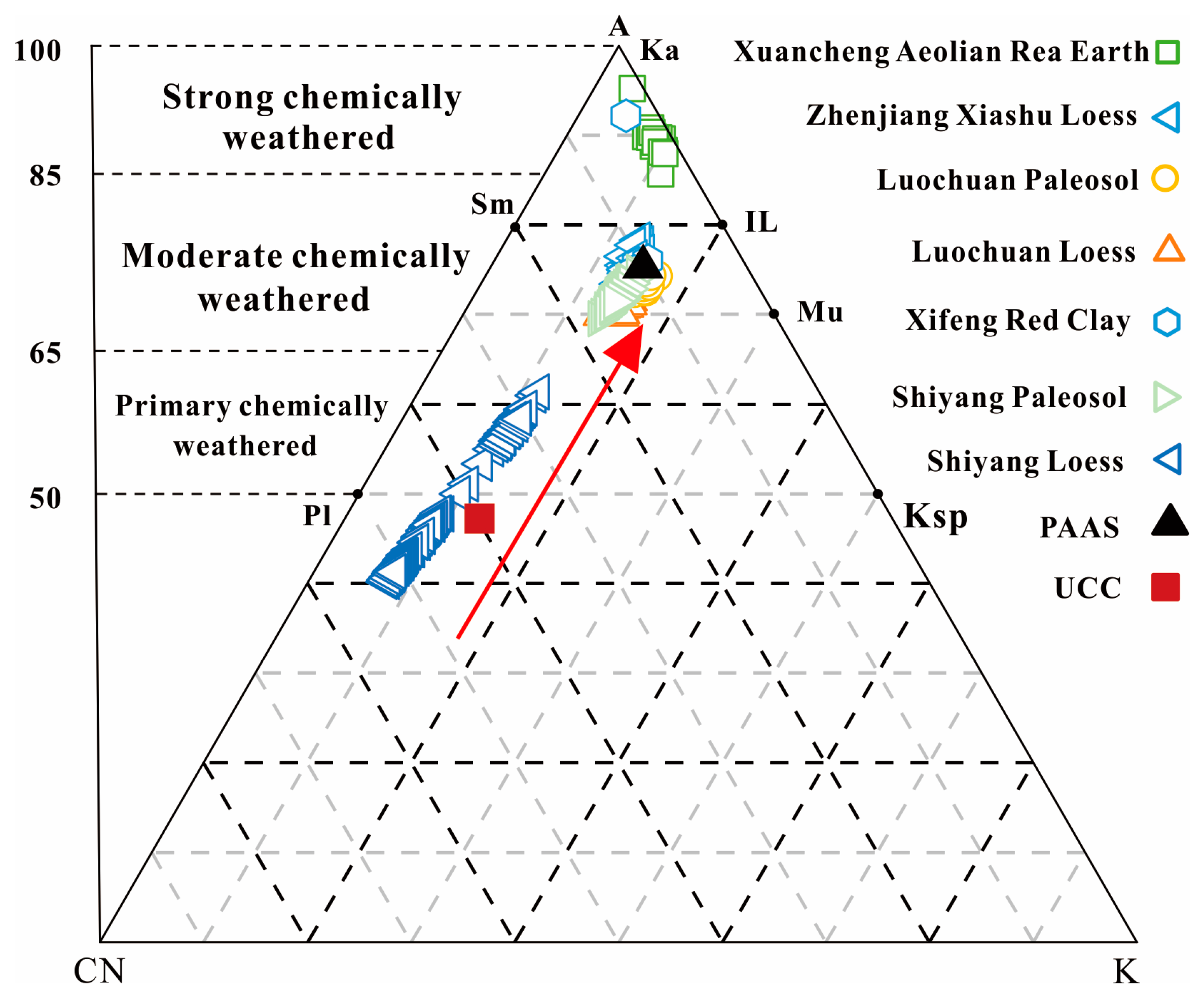
The triangular A-CN-K model effectively illustrates the chemical weathering trends of the stratigraphy within the profile [39] and their effects on the distribution of the Shiyang profile and other typical wind-formed sediments characterized in the map (Figure 4). We know that except for the Xuancheng aeolian rea earth located on the Sm-IL baseline, the data points for Shiyang loess, Shiyang paleosol, and other wind-formed sediments are predominantly situated in the upper region of the Pl-Ksp baseline and its vicinity. These points are roughly parallel to the chemical weathering trend line extending from the UCC to land-derived shale and the A-CN line, and they are closer to the plagioclase side and farther from the potassium feldspar side. The land-derived shales represent typical initial weathering products of the upper crust, and the trajectory from the upper crust to the land-derived shales suggests early continental weathering trends. The weathering trends of Shiyang loess, Shiyang paleosol, and other typical wind-formed sediments align with the chemical weathering trend line from the UCC to Land Source Shale, indicating that the components of the Shiyang profile are also derived from the extensive UCC. Most data points for the profile samples are positioned above the Pl-Ksp line, with the weathering trend running parallel to the A-CN line, suggesting that plagioclase is in the primary weathering stage and its decomposition results in the loss of Ca and Na. The data points for Shiyang loess are distanced from those of land-derived shale, indicating weak mineral weathering in the Shiyang loess. Notably, when compared with Luochuan loess, Shiyang loess displays a tendency to cluster closer to the A-CN side, suggesting a lower rate of Ca and Na loss; the data points for Shiyang paleosol are consistently positioned below those of Luochuan paleosol, indicating a lower rate of Ca and Na loss. From the triangular A-CN-K model diagram, the degree of Ca and Na loss can be ranked from smallest to largest as follows: Shiyang loess > Shiyang paleosol > Luochuan loess > Luochuan paleosol > Xifeng red clay > Zhenjiang Xiashu loess > Xuancheng aeolian rea earth.

4. Discussion

4.1. Source Analysis

Based on the elemental ratio distribution, reliable characteristic elements were selected as tracers for analysis, and the source areas of the sediments were inferred from the degree of similarity among these characteristic elements. The elements Ti and Al are relatively stable [15]. Generally, the degree of weathering and leaching during long-term deposition processes is relatively low, and the content of Ti in various rocks is comparatively high. Consequently, the TiO2/Al2O3 ratio is frequently employed as an index for provenance tracing [40,41]. The element K primarily exists in potassium feldspar, and its alteration typically occurs only under strong chemical weathering and leaching conditions. Since the Shiyang profile is in the primary weathering stage, the K2O/Al2O3 ratio also serves as an effective indicator for investigating sediment sources [15]. The chemical properties of Fe are relatively stable and can vary with sediment particle size. Thus, the Fe2O3/Al2O3 ratio can also be utilized as a source indicator in this study.
In the present study, the ratios of TiO2/Al2O3, K2O/Al2O3, and Fe2O3/Al2O3 from Shiyang loess, Shiyang paleosol, and other typical wind-formed sediments were plotted in scatter plots for comparison(Figure 5). The results indicate that the K2O/Al2O3, TiO2/Al2O3, and Fe2O3/Al2O3 ratios in the Shiyang loess and paleosol layers are similar to those found in Luochuan loess, Luochuan paleosol, Zhenjiang Xiashu loess, and Xifeng red clay. This similarity suggests that these deposits share a common source area and supports the hypothesis of wind-induced genesis for the Shiyang loess and paleosol. Notably, the K2O/Al2O3 index value of Xuancheng aeolian rea earth is lower than that of other profiles, while the TiO2/Al2O3 and Fe2O3/Al2O3 index values are higher. Overall, the main distribution patterns of the TiO2/Al2O3-K2O/Al2O3 and Fe2O3/Al2O3-K2O/Al2O3 ratios are distinctly different from those of other aeolian deposits, indicating that Xuancheng aeolian rea earth and these aeolian deposits are not homologous substances.
In particular, we note that the TiO2/Al2O3 and Fe2O3/Al2O3 values of the Shiyang profile are significantly lower than those of the other wind-formed sediments, suggesting that the Shiyang profile may have been sourced by other sedimentary materials. The Shiyang profile is located in the Weihe River basin, and the flowing water has a transporting effect on the sediment in the river, especially in the dry and cold periods. With strong wind transporting the local river terraces, the exposed sediment on the river floodplain may provide a part of the material source for the Shiyang profile. For example, scholars have evaluated the history and data of regional floods in the main tributaries of the middle of the Yellow River, finding that the laminated fine sand deposits originate from ancient flood flows [42,43]. The parallel or undulating stratification, along with unique stratigraphic fractures, makes them very prominent in Holocene profiles. Four ancient floodplain groups have been identified, and reconstructions show that the peak discharge reached its maximum at 15,000 m3/s around 11,500 years B.P., representing geological records of extreme floods that occurred in the past.
The study of loess sources is a complex and multifaceted scientific problem, and it is difficult to accurately trace the nuances of wind-dust accumulation and its potential source areas in northern China by relying only on the macronutrients of loess. Therefore, in this study, only a preliminary study of loess in the Shiyang profile was made, and many specific analyses are yet to be carried out.

4.2. The Indicative Significance of Comprehensive Parameters for Climate Evolution

After prolonged chemical weathering of loess profiles, active elements may be lost, or their concentrations may change due to volume limitations, leading to stable elements in the samples not accurately reflecting the migration and enrichment of elements during the depositional process [44]. Consequently, relying on a single macronutrient indicator to represent the climate evolution of these profiles can often yield inaccurate information. Therefore, in many cases, oxidation ratios of elements and epigenetic geochemical indicators are employed to elucidate the sedimentary environment and climate change [45].
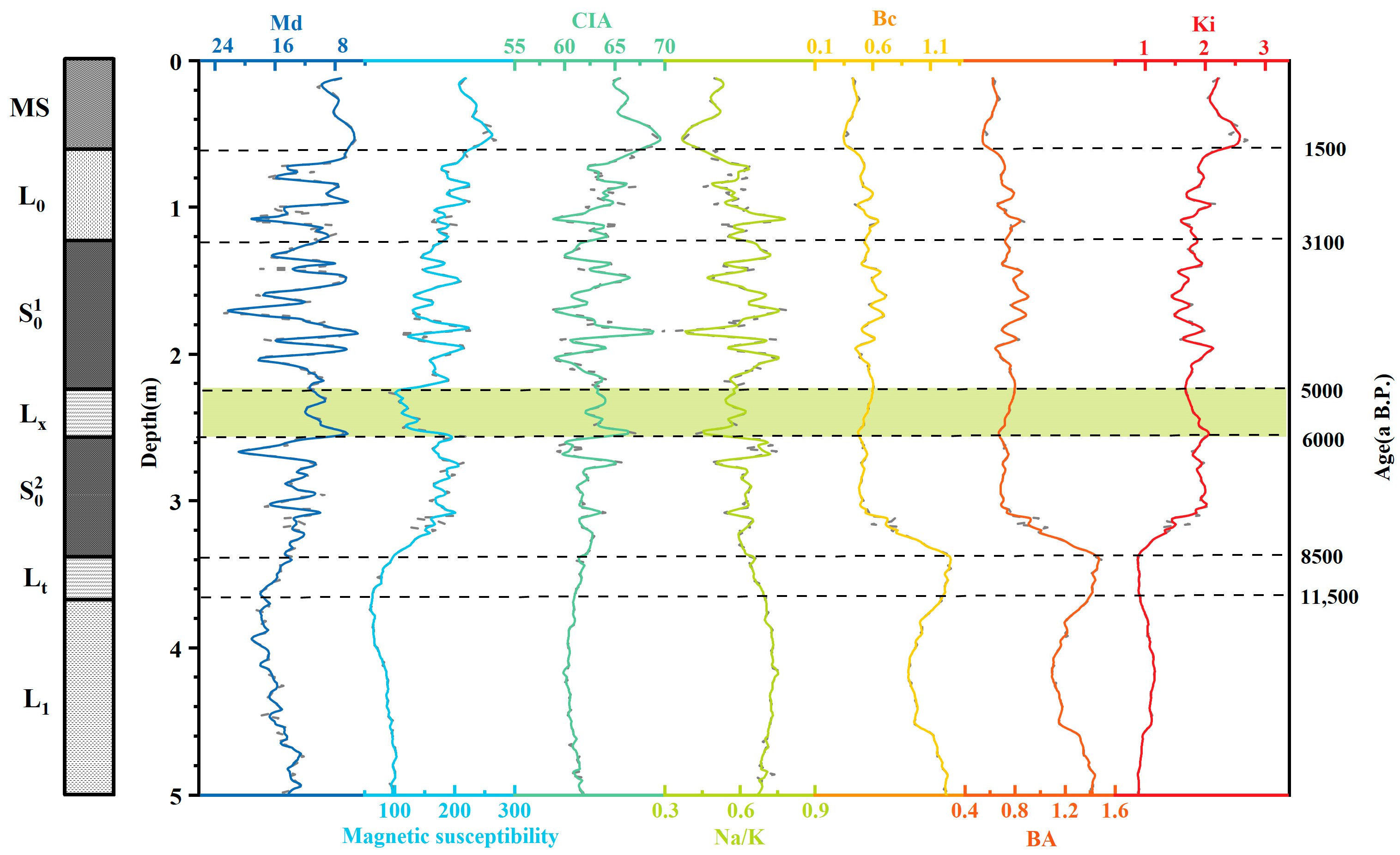
The BA value of soil (BA) [CaO + Na2O + K2O)/Al2O3] reflects the relationship between active and inert components in loess. Under warm and humid climatic conditions, the leaching of active elements is pronounced, resulting in a lower value of this index [46]. The Bc value of soil (Bc)[(CaO + Na2O)/Al2O3] serves as an indicator of the migration of chemical elements through leaching [47]. Due to the high chemical reactivity and mobility of Ca and Na, a low coefficient value signifies intense chemical weathering, which is indicative of a wet climate. The residual accumulation coefficient (Ki) (Al2O3 + Fe2O3)/(CaO + MgO + Na2O) reflects the intensity of soil formation [34]. In warm and humid climates, Na, Ca, and Mg are preferentially leached, leading to relative enrichment of Al and Fe. A higher coefficient value indicates a greater degree of soil formation. In general, the above three indicators reflect the relationship between the active and inert components of the elements and are closely related to climate. The climate change since the Holocene recorded in the Shiyang profile can be divided into six stages(Figure 6), and compared with other regional climate records, it is found that it has good consistency with adjacent regions and global change.
In the first stage (11,500–8500 a BP), the transitional loess layer Lt developed from Malan loess to paleosol. During this period, the magnetization rate increased significantly, while the median grain size decreased. Bc and BA gradually increased, peaking at this time, whereas Ki steadily declined, reaching its lowest point. These changes indicate a transition from a predominantly cold and dry climate to a warmer and more wet one, but cold and dry conditions still prevailed. Recently, scholars have utilized the developed GDGT pro to quantitatively reconstruct Holocene temperature changes in the Weinan loess profile. Their high-resolution MATmr reconstructions indicate that temperatures were relatively high during the early to mid-Holocene [48]. Additionally, research has shown a significant upward trend in element concentrations and geochemical indicators in the Chilanqiao site profile of the Guanzhong Basin [49]. Furthermore, other regions have also responded to the warming and humidification during this period; for example, the Kai’e profile shows that the climate in the early Holocene (10.0–8.6 ka B.P.) in the Gonghe Basin continuously developed towards a warmer and more humid state [50]. Pollen data from the northeastern Tibetan Plateau indicate an increase in humidity during the period of 10.2 (±0.4) ka B.P.—7.4 (±0.2) ka B.P. [51]. Moreover, the Asian summer monsoon index (SMI) also exhibited a sudden change at this time, reflecting a gradual warming trend [52].
In the second stage (8500–6000 a BP), this was the paleosol layer S 0 2 , the magnetization rate reached the peak of the change curve, while the grain size exhibited fluctuations at low values. The CIA and Na/K ratios displayed a strong inverse relationship, with several distinct peaks in the CIA corresponding to the troughs in the Na/K values. Additionally, Bc and BA had low values after a significant decrease characterized by fluctuations, whereas Ki fluctuated at elevated values following a substantial increase. These conditions indicate a marked improvement in the climate during this period compared with the previous stage, characterized by a gradual transition from cold and dry to warm and humid conditions, alongside an increase in summer winds. This made it an optimal period, marked by the highest temperature and precipitation levels since the Holocene.
In the third stage (6000–5000 a BP), this was the paleosol layer (Lx), characterized by a significant trough in magnetic susceptibility, larger particle diameters, a decrease in CIA values, a slight increase in Na/K values, and a weak upward trend in Bc and BA; the Ki exhibited a convex shape toward lower values, indicative of a rapid cooling and drought event during this period. This drought event is well documented in Holocene loess-paleosol profiles across various watersheds [53,54,55].
In the fourth stage (5000–3100 a BP), paleosol S 0 1 developed, characterized by fluctuating and generally high magnetic susceptibility, while the sediment grain size remained low. During this period, the CIA, Na/K ratio, alkalinity regression coefficient, leaching coefficient, and residual sediment coefficient exhibited several peaks and troughs. The combination of these indicators suggests that the climate experienced fluctuations between warm-wet and cold-dry conditions, although there was an overall trend of increasing temperature and precipitation. Concurrently, particle size analysis of the Weihe River NSC profile by Wang et al. indicated that the silt layer between 100 and 95 cm exhibited a very low magnetic susceptibility, providing a clear record of this climatic event [56]. Zha et al. [57] found that the existence of the Huxizhuang site near the HXZ-W profile of the secondary terrace of the Chishui River in Guanzhong is equivalent to the Longshan culture era, indicating that the ancestors lived and reproduced in the Chishui River valley in this section, engaging in agricultural cultivation and reclamation, indicating that this.
In the fifth stage (since 3100 a BP), the development of paleosol ceased, giving way to the formation of Holocene loess L0. Magnetic susceptibility was slightly lower than that in the previous stages, while the median grain size values of the sediments fluctuated. The CIA values, Bc, and BA exhibited lower values, whereas the Na/K values and Ki shifted to higher levels. These changes indicate that East Asian winter winds became dominant, leading to a climate that alternated with more arid conditions, accompanied by a decrease in soil-forming processes during this period. Soil formation weakened, and leaching and transport phenomena became significant. The topsoil layer displayed concave valleys or convex peaks across all indicators, with the magnetic susceptibility, CIA, and Ki showing an upward trend. Conversely, the grain size, Bc, and Ki exhibited minor troughs. This pattern suggests a pronounced leaching and transport effect, indicating that soil-forming processes were significant during this period and were primarily influenced by human activities. Previous research in other regions supports these findings. High-resolution geological records from different regions indicate that the late Holocene climate became cooler and drier. For instance, the stalagmites from the Xiangshui Cave in Guilin effectively document the decline of the East Asian summer monsoon during this period [58]. Changes in the constant element indicators of two loess-paleosol sequences from semi-humid temperate and humid subtropical regions further support these findings [59].

5. Conclusions

(1)
The Shiyang profile exhibits a stratigraphic sequence consisting of modern meadow soil (MS), early Holocene loess (L0), middle Holocene paleosol ( S 0 1 ), Holocene transitional loess (Lx), Holocene paleosol ( S 0 2 ) , Holocene transitional loess (Lt), and Malan loess (L1), arranged from top to bottom.
(2)
The primary chemical compositions of the Shiyang loess—paleosol—along with the curves obtained after UCC standardization, closely resemble those of typical wind-formed deposits, with the exception of the Xuancheng wind-dusted loess. This similarity indicates that the Shiyang loess-paleosol has a wind-formed origin;
(3)
The Shiyang profile is characterized by primary chemical weathering, and by comparing the intensity of chemical weathering among typical wind-formed deposits in other regions, the sequence from strongest to weakest is as follows: Xuancheng aeolian rea earth > Xifeng red clay, PAAS, and Zhenjiang Xiashu loess > Shiyang paleosol and Luochuan paleosol > Luochuan loess > Shiyang loess > UCC.
(4)
The K2O/Al2O3 and TiO2/Al2O3 ratios of Shiyang loess and paleosol are relatively similar to those of Luochuan loess, Luochuan paleosol, Zhenjiang Xiashu loess, and Xifeng red clay, suggesting a common source area. In contrast, the TiO2/Al2O3 and Fe2O3/Al2O3 ratios are significantly lower than those of other wind-formed deposits, indicating that the Shiyang profile may be influenced by different sedimentary materials.
(5)
The paleoclimate evolution of the Weinan Shiyang area can be divided into six distinct stages: 11,500 to 8500 a BP, marked by a continuously cold and dry climate; 8500 to 6000 a BP, which corresponds to the middle Holocene warm and humid period, during which the climate transitioned from cold–dry to warm–humid; 6000 to 5000 a BP, a period characterized by rapid and sudden cooling; 5000 to 3100 a BP, characterized by climatic fluctuations between warm-wet and cold-dry conditions, indicating climate change and instability; since 3100 a BP, the climate has once again become cooler.

Author Contributions

Conceptualization, J.C. and H.C.; methodology, H.C.; software, J.C. and C.L.; formal analysis, Q.D. and Z.Y.; data curation, H.C., Q.D. and P.W.; writing—original draft preparation, J.C.; writing—review and editing, H.C. All authors have read and agreed to the published version of the manuscript.

Funding

This research was funded by the Young Scientists Fund of the National Natural Science Foundation of China (No. 42307555).

Institutional Review Board Statement

Not applicable.

Informed Consent Statement

Not applicable.

Data Availability Statement

The data presented in this study are available on request from the corresponding author. The data are not publicly available due to privacy.

Conflicts of Interest

The authors declare no conflicts of interest.

References

  1. Liu, D.S.; Lu, Y.T.; Zheng, H.H. Loess and Environment; Beijing Science Press: Beijing, China, 1985. (In Chinese) [Google Scholar]
  2. Ding, Z.L.; Sun, J.M.; Yang, S.L.; Liu, T.S. Geochemistry of the Pliocene red clay formation in the Chinese Loess Plateau and implications for its origin, source provenance and paleoclimate change. Geochim. Cosmochem. Acta 2001, 65, 901–913. [Google Scholar] [CrossRef]
  3. Chen, F.H.; Xu, Q.H.; Chen, J.H.; John, H.; Birks, B.; Liu, J.B.; Zhang, S.R.; Jin, L.Y.; An, C.B.; Telford, R.J.; et al. East Asian summer monsoon precipitation variability since the last deglaciation. Sci. Rep. 2015, 5, 11186. [Google Scholar] [CrossRef] [PubMed]
  4. Huang, X.Z.; Xiang, L.X.; Lei, G.L.; Sun, M.J.; Qiu, M.H.; Storozum, M.; Huang, C.; Munkhbayar, C.; Demberel, O.; Zhang, J.; et al. Sedimentary Pediastrum record of middle-late Holocene temperature change and its impacts onearly human culture in the desert-oasis area of northwestern China. Quat. Sci. Rev. 2021, 265, 107054. [Google Scholar] [CrossRef]
  5. Porter, S.C.; An, Z.S. Correlation between climate events in the North Atlantic and China during the last glaciation. Nature 1995, 375, 305–308. [Google Scholar] [CrossRef]
  6. Xiao, J.L.; Porter, S.C.; An, Z.S.; Kumal, H.; Yoshikawa, S. Grain size of quart as an indicator of winter monsoon strength on the loess plateau of central China during the last 13000 yr. Quat. Res. 1995, 43, 22–29. [Google Scholar] [CrossRef]
  7. Paterson, G.A.; Heslop, D. New methods for unmixing sediment grain size data. Geochemistry 2015, 16, 4494–4506. [Google Scholar] [CrossRef]
  8. Lu, H.Y.; An, Z.S. Paleoclimatic significance of loess grain size composition in Luochuan. Chin. Sci. Bull. 1997, 42, 66–69, (In Chinese with English abstract). [Google Scholar]
  9. Kukla, G.; Heller, F.; Liu, X.M.; Chun, X.T.; Sheng, L.T.; An, Z.S. Pleistocene climates in China dated by magnetic-susceptibility. Geology 1988, 16, 811–814. [Google Scholar] [CrossRef]
  10. Liu, X.M.; Rolph, T.; Bloemendal, J.; Shaw, J.; Liu, T.S. Quantitative estimates of palaeoprecipitation at Xifeng, in the loess plateau of China. Palaeogeogr. Palaeoclimatol. Palaeoecol. 1995, 113, 243–248. [Google Scholar] [CrossRef]
  11. Heller, F.; Shen, C.D.; Beer, J.; Liu, X.M.; Liu, T.S.; Bronger, A.; Suter, M.; Bonani, G. Quantitative estimates of pedogenic ferromagnetic mineral formation in Chinese loess and paleoclimatic implications. Earth Planet. Sci. Lett. 1993, 114, 385–390. [Google Scholar] [CrossRef]
  12. Guo, Z.T.; Liu, T.S.; Fedoroff, N.; Wei, L.Y.; Ding, Z.L.; Wu, N.Q.; Lu, H.Y.; Jiang, W.Y.; An, Z.S. Climate extremes in Loess of China coupled with the strength of deep-water formation in the North Atlantic. Glob. Planet. Chang. 1998, 18, 113–128. [Google Scholar] [CrossRef]
  13. Liu, T.S.; Ding, Z.L. Loess and the environment: A review of the loess research in China. Quat. Sci. Rev. 1998, 17, 1037–1050. [Google Scholar]
  14. Sun, J.M.; Wang, Y.J. Geochemical characteristics of loess and their implications for climate change in the Loess Plateau, China. J. Geophys. Res. Earth Surf. 2016, 121, 743–758. [Google Scholar]
  15. Hao, Q.Z.; Guo, Z.T.; Qiao, Y.S.; Xu, B.; Oldfield, F. Geochemical evidence for the provenance of middle Pleistocene loess deposits in southern China. Quat. Sci. Rev. 2010, 29, 3317–3326. [Google Scholar] [CrossRef]
  16. Xie, Y.Y.; Kang, C.G.; Chi, Y.P.; Du, H.R.; Wang, J.X.; Sun, L. The loess deposits in Northeast China: The linkage of loess accumulation and geomorphic-climatic features at the easternmost edge of the Eurasian loess belt. J. Asian Earth Sci. 2019, 181, 103914. [Google Scholar] [CrossRef]
  17. Xiong, S.F.; Ding, Z.L.; Zhu, Y.J.; Zhou, R.; Lu, H.J. A ~6 Ma chemical weathering history, the grain size dependence of chemical weathering intensity, and its implications for provenance change of the Chinese loess-red clay deposit. Quat. Sci. Rev. 2010, 29, 1911–1922. [Google Scholar] [CrossRef]
  18. Yang, Y.Z.; Yue, D.P.; Zhao, J.B.; Wang, X.N.; Liu, Y.T.; Liu, R. Characteristics of geochemical weathering of L3 and S3 loess-paleosol section in the Hengshan area, Shaanxi Province. Prog. Geogr. 2023, 42, 364–379, (In Chinese with English abstract). [Google Scholar] [CrossRef]
  19. Liu, A.N.; Pang, J.L.; Huang, C.C.; Wang, L.J. Element distributions of the Zhuanglang Holocene loess-paleosol sequence, Gansu Province and its significance. Geochimica 2006, 35, 453–458, (In Chinese with English abstract). [Google Scholar]
  20. Shi, T.Y.; Zhang, Y.Y.; Zhai, Q.M.; Li, H.B.; Liu, C.; Zhou, X.W.; Chen, P.; Chen, L. Characteristics of weathering of the loess-paleosol sequences in the Late Glacial Period to Middle Holocene in Linfen Basin and implication for climatic significance. Mar. Geol. Quat. Geol. 2023, 43, 181–191, (In Chinese with English abstract). [Google Scholar]
  21. Zhang, Y.Z.; Xiao, Q.L.; Zhu, Y.; Wang, N.L.; Wu, M.L.; Li, Y.F.; Li, J.X.; Chen, D.; Huang, X.L.; Wang, S.K.; et al. Char and soot records of the Holocene fire history and its implications for climate-vegetation change and human activities within the Guanzhong Basin, southern Loess Plateau, China. Sci. Total Environ. 2024, 911, 168564. [Google Scholar] [CrossRef]
  22. Rits, D.S.; Prins, M.A.; Troelstra, S.R.; Van, B.R.T.; Zheng, Y.; Beets, C.J.; Wang, B.; Li, X.Q.; Zhou, J.; Zheng, H.B. Facies analysis of the Middle and Late Quaternary sediment infill of the northern Weihe Basin, central China. J. Quat. Sci. 2016, 31, 152–165. [Google Scholar] [CrossRef]
  23. Wang, Y.C.; Lu, H.Y.; Wang, K.X.; Wang, Y.; Li, Y.X.; Clemens, S.; Lv, H.Z.; Huang, Z.H.; Wang, H.L.; Hu, X.Z.; et al. Combined high-and low-latitude forcing of East Asian monsoon precipitation variability in the Pliocene warm period. Sci. Adv. 2020, 6, eabc2414. [Google Scholar] [CrossRef] [PubMed]
  24. Zhao, L.; Lu, H.Y.; Tang, L.Y. Cenozoic palynological records and vegetation evolution in the Weihe Basin, Central China. Quat. Sci. 2018, 38, 1083–1093. [Google Scholar]
  25. Zhao, L.; Lu, H.Y.; Wang, H.L.; Zhang, H.Y.; Lei, F.; Tang, L.Y. Paleofire dynamics in response to climate change during Late Miocene derived from microcharcoal records in the Weihe Basin. Quat. Int. 2023, 671, 44–51. [Google Scholar] [CrossRef]
  26. Liu, X.X.; Sun, Y.B.; Vandenberghe, J.; Li, Y.; An, Z.S. Palaeoenvironmental implication of grain-size compositions of terrace deposits on the western Chinese Loess Plateau. Aeolian Res. 2018, 32, 202–209. [Google Scholar] [CrossRef]
  27. Geiss, C.E.; Zanner, C.W. Sediment magnetic signature of climate in modern loessic soils from the Great Plains. Quat. Int. 2007, 162–163, 97–110. [Google Scholar] [CrossRef]
  28. Jia, Y.F.; Pang, J.L.; Huang, C.C. PH value′s measurement and research of its palaeoclimatic meaning in the Holocene loess section. J. Shaanxi Norm. Univ. Nat. Sci. Ed. 2004, 32, 102–105. [Google Scholar]
  29. Li, P.H. The Environment Change and Its Social Impact during Holocene in Fufeng of Zhou Yuan Region; Shaanxi Normal University: Xi’an, China, 2002. [Google Scholar]
  30. Chen, J.; Liu, L.W.; Ji, J.F.; Yang, J.D.; Chen, Y.; An, Z.S.; Lu, H.Y. Variations in chemical compositions of the Aelion dust in Chinese Loess Plateau over the past 2.5 Ma and chemical weathering in Asian island. Sci. China Ser. D 2001, 31, 136–145. [Google Scholar]
  31. Li, X.S.; Han, Z.Y.; Yang, S.Y.; Chen, Y.Y.; Wang, Y.B.; Yang, D.Y. Chemical Weathering Intensity and Element Mi-gration Features of the Xiashu Loess Profile in Zhenjiang. Acta Geogr. Sin. 2007, 62, 1174–1184, (In Chinese with English abstract). [Google Scholar]
  32. Chen, Y.; Chen, J.; Liu, L.W. Chemical composition and characterization of chemical weathering of late tertiary red clay in Xifeng, Gansu province. J. Geomech. 2001, 7, 167–175, (In Chinese with English abstract). [Google Scholar]
  33. Li, X.S.; Yang, D.Y.; Lu, H.Y. Oxide-geochemistry features and paleoclimatic record of the aeolian-dust depositional sequence in southern Anhui. Mar. Geol. Quat. Geol. 1999, 19, 75–82, (In Chinese with English abstract). [Google Scholar]
  34. Taylor, S.R.; McLennan, S.M. The Continental Crust Its Composition and Evolution: An Examination of the Geochemical Record Preserved in Sedimentary Rocks; Blackwell: Oxford, UK, 1985. [Google Scholar]
  35. Iturri, L.A.; Funk, R.; Sommer, M.; Buschiazzo, D.E. Elemental composition of wind-blown sediments from contrasting textured soils. Aeolian Res. 2021, 48, 100656. [Google Scholar] [CrossRef]
  36. Nesbitt, H.W.; Young, G.M. Early Proterozoic Climates and Plate Motions Inferred from Major Element Chemistry of Lutites. Nature 1982, 299, 715–717. [Google Scholar] [CrossRef]
  37. Nesbitt, H.W. Mobility and Fractionation of Rare Earth Elements during Weathering of a Granodiorite. Nature 1979, 279, 206–210. [Google Scholar] [CrossRef]
  38. Young, G.M.; Nesbitt, H.W. Paleoclimatology and provenance of the glaciogenic Gowganda Formation (Paleoproterozoic), Ontario, Canada: A chemostratigraphic approach. GSA Bull. 1999, 111, 264–274. [Google Scholar] [CrossRef]
  39. Nesbitt, H.W.; Markovics, G. Chemical Processes Affecting Alkalis and Alkaline Earths during Continental Weathering. Geochim. Cosmochim. Acta 1980, 44, 1659–1666. [Google Scholar] [CrossRef]
  40. Sun, J.M. Provence of loess material and formation of loess deposits on the Chinese Loess Plateau. Earth Planet. Sci. Lett. 2002, 203, 845–859. [Google Scholar] [CrossRef]
  41. Sheldon, N.D. Abrupt chemical weathering increases across the Permian-Triassic boundary. Palaeogeogr. Palaeoclimatol. Palaeoecol. 2006, 231, 315–321. [Google Scholar] [CrossRef]
  42. Guo, Y.Q.; Huang, C.C.; Pang, J.L.; Zhou, Y.L.; Zha, X.C.; Mao, P.N. Reconstruction paleoflood hydrologyusing slackwater flow depth method in the Yanhe River valley, middle YellowRiver Basin, China. J. Hydrol. 2017, 544, 156–171. [Google Scholar] [CrossRef]
  43. Li, X.G.; Huang, C.C. Holocene palaeoflood events recorded by slackwater deposits along the Jin-shan Gorges of the middle Yellow River, China. Quat. Int. 2017, 453, 85–95. [Google Scholar] [CrossRef]
  44. Zhang, W.X.; Shi, Z.T.; Zhang, H.C.; Ming, Q.Z.; Su, H.; Liu, Y. Geochemical characteristics and environmental significance of the loess-paleosol sequence in the westerly area of China. Quat. Sci. 2011, 31, 812–821, (In Chinese with English abstract). [Google Scholar]
  45. Hu, M.J.; Yang, A.L.; Zhang, W.L. Environmental Evolution since the Middle-Late Holocene in the Maqu Plateau Reflected by Constant Element Oxides Content and Ratios. J. Desert Res. 2015, 35, 313–321, (In Chinese with English abstract). [Google Scholar]
  46. Chen, Y.M.; Shu, Q.; Zhang, M.H. Environmental evolution information recorded in the Xiashu loess (250–100 ka) in Nanjing, China. Geol. Sci. Technol. Inf. 2014, 33, 55–59. [Google Scholar]
  47. Wu, L.; Wang, X.Y.; Mo, D.W.; Zhou, K.S.; Guan, H.C.; Zhu, C. Elemental geochemistry of the Lingjiatan site in Hanshan, east Chaohu Lake Basin. J. Stratigr. 2015, 39, 443–453, (In Chinese with English abstract). [Google Scholar]
  48. Zheng, Y.H.; Kang, S.G.; Li, J.H.; Yu, S.Y.; Lan, M.W.; Wang, J.Y. A sedimentary lipid biomarker record of Holocene temperature variations and drought events in northern China. Palaeogeogr. Palaeoclimatol. Palaeoecol. 2024, 654, 112468. [Google Scholar] [CrossRef]
  49. Zhu, Y.; Zhang, Y.Z.; Wang, N.L.; Li, S.H.; Wu, M.L.; Li, Y.F.; Li, J.X.; Pang, J.L.; Jin, Y.; Chen, D.; et al. Weathering and pedogenesis of the Holocene aeolian loess-paleosol sections in the Guanzhong Basin on the Chinese Loess Plateau. J. Asian Earth Sci. 2024, 276, 1367–9120. [Google Scholar] [CrossRef]
  50. Zhao, Y.; Yu, Z.C.; Tang, Y.; Li, H.; Yang, B.; Li, F.R.; Zhao, W.W.; Sun, J.H.; Chen, J.H.; Li, Q.; et al. Peatland initiation and carbon accumulation in China over the last 50,000 years. Earth-Sci. Rev. 2014, 128, 139–146. [Google Scholar] [CrossRef]
  51. Zhou, S.; Zhang, J.W.; Cheng, B.; Zhu, H.N.; Lin, J.X. Holocene pollen record from Lake Gahai, NE Tibetan Plateau and its implications for quantitative reconstruction of regional precipitation. Quat. Sci. Rev. 2024, 326, 108504. [Google Scholar] [CrossRef]
  52. An, Z.; Colman, S.M.; Zhou, W.J.; Li, X.Q.; Brown, E.T.; Jull, A.J.T.; Cai, Y.J.; Huang, Y.S.; Lu, X.F.; Chang, H.; et al. Interplay between the Westerlies and Asian monsoon recorded in Lake Qinghai sediments since 32 Ka. Sci. Rep. 2012, 2, 619. [Google Scholar] [CrossRef] [PubMed]
  53. Huang, C.C.; Pang, J.L.; Huan, P.A. An early Holocene erosion phase on the loess tableland in the southern Loess Plateau of China. Geomorphology 2002, 43, 209–218. [Google Scholar] [CrossRef]
  54. Huang, C.C.; Pang, J.L.; Huang, P.; Hou, C.H.; Han, Y.P. Holocene climatic events on the loess tableland in western Guanzhong Basin, China. Arid Land Geogr. 2002, 25, 10–15. [Google Scholar]
  55. Huang, C.C.; Pang, J.L.; Huang, P.; Hou, C.H.; Han, Y.P. High-resolution studies of the oldest cultivated soils in the southern Loess Plateau of China. Catena 2002, 47, 29–42. [Google Scholar] [CrossRef]
  56. Wang, H.S.; Huang, C.C.; Zhou, Y.L.; Pang, J.L.; Zha, X.C.; Gu, H.L. OSL Dating of the Palaeoflood Events in the Middle Reaches of the Weihe River. Acta Sedimentol. Sin. 2012, 30, 346–355, (In Chinese with English abstract). [Google Scholar]
  57. Zha, X.C.; Huang, C.C.; Pang, J.L. Holocene Extreme Floods and Environmental Change of Qishuihe River in Western Guanzhong Basin. Acta Geogr. Sin. 2007, 3, 291–300, (In Chinese with English abstract). [Google Scholar]
  58. Zhang, M.L. A 6000-year high-resolution climatic record from a stalagmite in Xiangshui Cave, Guilin, China. Holocene 2004, 14, 697–702. [Google Scholar] [CrossRef]
  59. Bian, H.Y.; Pang, J.L.; Huang, C.C.; Zhou, Y.L. Geochemical characterization of loess-paleosol sequences: Comparison between the upper reaches of the Hanjiang and Weihe river valleys, China. J. Geogr. Sci. 2017, 27, 95–108. [Google Scholar] [CrossRef]
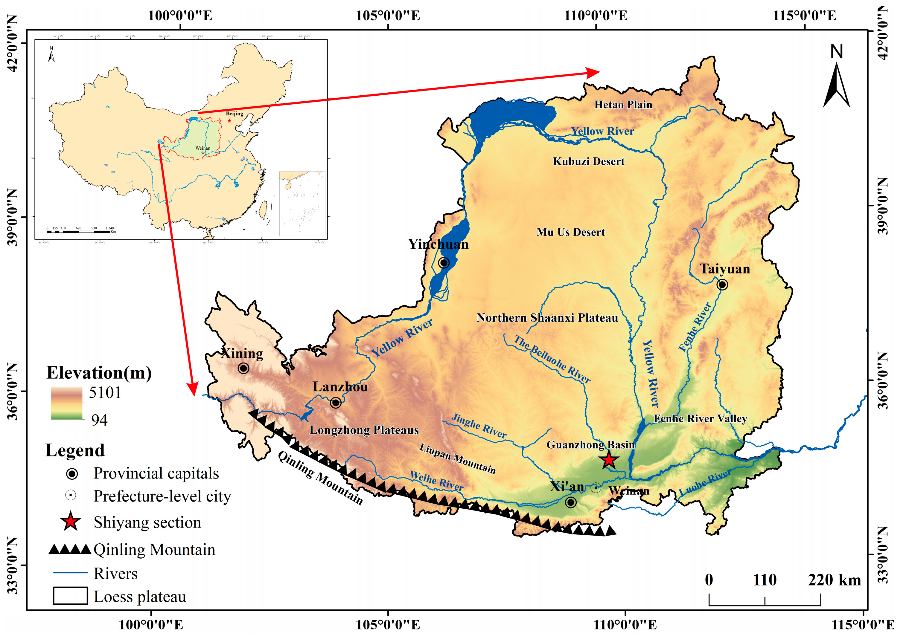
Figure 1. Location of the Shiyang profile.
Atmosphere 15 01227 g001
Figure 2. Comparison of the stratigraphic age frames of the Weinan Shiyang (SY), Laoguantai (LGT), [28] and Jiangyangcun (JYC) [29] profiles.
Atmosphere 15 01227 g002
Figure 3. Distribution of the UCC standardized curves of major elements in the Shiyang profile and other wind-formed sediments.
Atmosphere 15 01227 g003
Figure 4. A-CN-K chemical weathering trend of the Shiyang profile with other wind-formed sediments.
Atmosphere 15 01227 g004
Figure 5. (a) Scatter diagram of the K2O/Al2O3-TiO2/Al2O3 ratio in the Shiyang profile with respect to that in other wind-formed deposits; (b) scatter diagram of the K2O/Al2O3-Fe2O3/Al2O3 ratio in the Shiyang profile with respect to that in other wind-formed deposits.
Atmosphere 15 01227 g005
Figure 6. Integrated parameter curves of the Shiyang loess section.
Atmosphere 15 01227 g006
Table 1. Stratigraphic characterization of the Shiyang profile.
Depth/(m)StratumStratigraphic Characterization
0–0.61Grayish-yellow sub-sandy soil, modern till layer, loose structure, modern wormholes, well-developed root system, clear signs of human activity, high porosity, and more homogeneous texture
0.6–1.22Gray-yellow loess layer, subclay; dense, hard structure with multiple layers of horizontally developed laminae with abundant mycorrhizal bodies and modern punching holes; roots are rare
1.2–2.23Dark yellow paleo-soil layer, clayey, dense, and homogeneous structure with abundant development of mycorrhizae
2.2–2.64Gray-yellow subclay, weakly developed degree of paleo-soil interbedding, agglomerates, looser structure, pore development
2.6–3.45Dark gray and black clayey, sub-clayey soil, dense and hard texture, with a large number of snails and other animal fossils in between
3.4–3.66Light yellow loam, fine powdery sandy, loose structure, no fungus bodies, few modern roots
3.6–5.07Pale yellow loam, fine chalky sandy, structurally homogeneous, loose, and numerous modern wormholes present
Table 2. Comparison of the major element content (%) in the Shiyang profile with that in other aeolian deposits.
Sample
Location
SiO2Al2O3TiO2Fe2O3CaOMgOK2ONa2OMnOP2O5CIA
SYPMax66161558.0033200070
Min51121342210058
Avg60131462320062
SYLMax64151513332067
Min52111312221060
Avg551213102220061
LCP [30]Avg65.1814.790.755.120.832.213.151.410.080.1167.36
LCL [30]Avg66.4014.200.734.811.022.293.011.660.070.1563.73
ZJL [31]Avg68.0713.320.815.31.001.612.350.920.090.1870.45
XF [32]Avg63.7515.050.765.280.902.893.001.160.080.1570.04
XC [33]Avg68.7713.711.066.520.110.541.380.140.040.0687.55
UCC [34]Avg66.0015.200.505.004.202.203.403.900.060.5047.92
PASS [34]Avg62.8018.900.167.221.302.203.701.200.111.0070.36
Note: SYP is Shiyang paleosol; SYL is Shiyang loess; LCP is Luochuan paleosol; LCL is Luochuan loess; ZJL is Zhenjiang Xiashu loess; XF is Xifeng red clay; XC is Xuancheng aeolian rea earth.
Disclaimer/Publisher’s Note: The statements, opinions and data contained in all publications are solely those of the individual author(s) and contributor(s) and not of MDPI and/or the editor(s). MDPI and/or the editor(s) disclaim responsibility for any injury to people or property resulting from any ideas, methods, instructions or products referred to in the content.