1. Introduction
Deteriorating air quality is a major health and environmental concern worldwide, and in South Africa (SA) [
1,
2]. In 2019, air pollution caused 1.1 million deaths in Africa, with household air pollution contributing to 697,000 deaths and ambient air pollution accounting for 394,000 [
3]. Deaths from air pollution rose from 361,000 in 2015 to 383,000 in 2019, particularly in highly developed countries [
3]. Not only is the degradation of air quality significant due to the health risks posed to humans, but it also impacts critical atmospheric processes by altering cloud microphysical and reflective properties [
4].
The sources and impacts of aerosol pollution on both climate change and air quality are inexorably linked [
5]. Regional air quality management is therefore paramount to reducing short-lived climate-forcing pollutants that impact climate and health [
6]. However, regional concentrations of particulate matter (PM) are highly variable in space and time and are affected by transboundary, fugitive sources, such as biomass burning [
7]. Aerosols emitted from these sources are injected into the troposphere and transported to different areas outside the vicinity of the source in the form of aerosols or smoke plumes [
7]. The spatial and temporal dynamics of aerosol plumes complicate the accurate measurement of PM by current monitoring methods, reducing the effectiveness of mitigation strategies. A comprehensive understanding of plume characteristics is essential to develop effective management policies and plans.
Plumes are typically defined as a stream of a particular substance, such as liquid, gas, or particles, moving through another medium [
8]. In the context of air pollution, a “plume” refers to a long, nearly horizontal region of polluted air that extends downwind from a source, such as a smokestack [
8]. This usage of the term contrasts with the definition of a “plume” in atmospheric boundary layer (ABL) studies, where it denotes a relatively wide, nearly vertical updraught of buoyant air that convectively overturns [
9]. Given that smoke plumes emitted into the boundary layer can be dispersed by convective plumes, it is crucial to distinguish between these two definitions to avoid confusion. In this study, the term “plume” is used to refer to streams of pollution, more specifically, particulate aerosols that result from sources such as wildfires.
The dynamics of smoke plumes has been the subject of numerous scientific investigations. In particular, the Southern African Regional Science Initiatives (SAFARI 92 and SAFARI 2000) have documented the large-scale characteristics and transport of biomass burning emissions and plumes in southern Africa [
10]. Plumes have been shown to extend more than a few thousand kilometres and can be several hundred kilometres wide [
10,
11,
12]. In southern Africa, the most well-documented plume, known as the “river of smoke”, is characterised by sharply defined boundaries that give it the appearance of a “river” [
10]. Over time, the smoke from these plumes is transported off the southeastern coast of Africa to the south-western Indian Ocean [
10,
11,
12]. Despite these insights, research on the regional-scale impacts of biomass burning plumes, particularly in the context of air quality management, remains insufficient due to limitations in current monitoring methods.
In the global South, the number of surface monitoring stations is limited, and remote sensing measurements from spaceborne platforms offer an alternative [
13]. During the past two decades, aerosol remote sensing has evolved with additional satellite launches since the introduction of NASA’s Terra and Aqua satellites, expanding the scientific community’s ability to retrieve parameters related to aerosol loading, particle properties, and plume heights [
14]. In the future, advances are expected to incorporate hyperspectral and polarimetric sensors, enhanced algorithms applying machine learning, and the integration of data from multiple sources [
14]. However, despite the promise of satellite-based monitoring, the limitations inherent in spaceborne remote sensing, such as the inability to capture low-level sources and limited temporal resolution due to overpass times, underscore the need for ground-based measurements [
14].
Remote sensing on the ground remains essential to validate satellite data, understand local air quality dynamics, and inform effective management policies [
15]. Instruments such as LIDAR, sun photometers, and radiometers are commonly used to retrieve optical properties of aerosols, vertical profiles, and particle concentrations at various altitudes [
15]. These measurements not only offer detailed information on local air quality, but also serve as critical validation tools for satellite data. As technology advances, ground-based systems are increasingly integrating with spaceborne sensors to enhance the accuracy of aerosol characterisation, leveraging data from both passive and active sensors [
14]. One such integration is the use of weather radars for the detection of aerosols and plumes, which is based on the established role of radars in monitoring atmospheric conditions [
16,
17]. Weather radar offers a powerful method for monitoring aerosol plumes, providing real-time data on plume structure, composition, and dynamics. The unique ability of radar to detect ash and debris, particularly through dual-polarised radar technology, has opened new avenues for understanding the behaviour of aerosols in the atmosphere, especially during extreme events such as wildfires.
Research by McCarthy et al. (2019) highlights the past use of weather radar to understand the dynamics of fire and smoke plumes [
17]. Studies have shown that radar can detect ash and debris, referred to as pyrometeors, driven by fires [
17]. Dual-polarised radar has been particularly useful in identifying the structure and composition of plumes. Melnikov et al. (2009) demonstrated that the polarimetric signatures of smoke plumes typically show low correlation coefficients and high differential reflectivity, indicative of the presence of non-spherical ash particles [
18]. Furthermore, investigations by Banta et al. (1992) revealed that the observed reflectivities from wildfire plumes could be attributed to large ash particles and debris, which differ significantly from typical meteorological scatterers [
19]. These insights have been further supported by studies like those of Jones et al. (2009), who used dual-polarised radar to characterise an apartment fire plume, concluding that ash and debris were the primary scatterers observed [
20,
21].
The real-time monitoring capability and high spatial resolution of weather radar can significantly contribute to understanding the spatial and temporal dynamics of smoke plumes, which is critical to effective air quality management and policy development. However, current approaches to using weather radar for aerosol plume characterisation are limited. In light of this gap, this study aims to develop a radar-based methodology for identifying and characterising aerosol plumes from non-industrial sources, such as biomass burning. The objectives of this study are to (1) demonstrate the effectiveness of the methodology in detecting and discerning aerosol plumes from meteorological events, (2) evaluate the utility of the spatial and temporal characteristics derived, and (3) evaluate the practical application of the methodology for air quality management. The results of case studies of plume events in June and August 2013 are discussed to achieve the aim and objectives.
The methodology developed in this study uses existing infrastructure and routine observations that are readily available for meteorological purposes, thus demonstrating an additional application for air quality management. Using radar systems and satellite data, which are typically employed for weather monitoring, this research highlights how these resources can be effectively adapted to track and manage aerosol plumes. This approach not only improves the scientific understanding of plume dynamics, but also provides a cost-effective solution for regions lacking comprehensive air quality monitoring networks.
2. Data and Methods
The methodology, as illustrated in
Figure 1, entails several key stages. High-resolution volumetric reflectivity data were obtained, subject to rigorous quality control to remove non-meteorological echoes. The adapted Thunderstorm Identification, Tracking, Analysis, and Nowcasting (TITAN) algorithm was used to identify and track aerosol plumes using optimised parameters to differentiate plumes from other atmospheric phenomena. Post-processing involved compiling a database of detected plumes, followed by an analysis of the spatial and temporal characteristics.
2.1. Radar Data
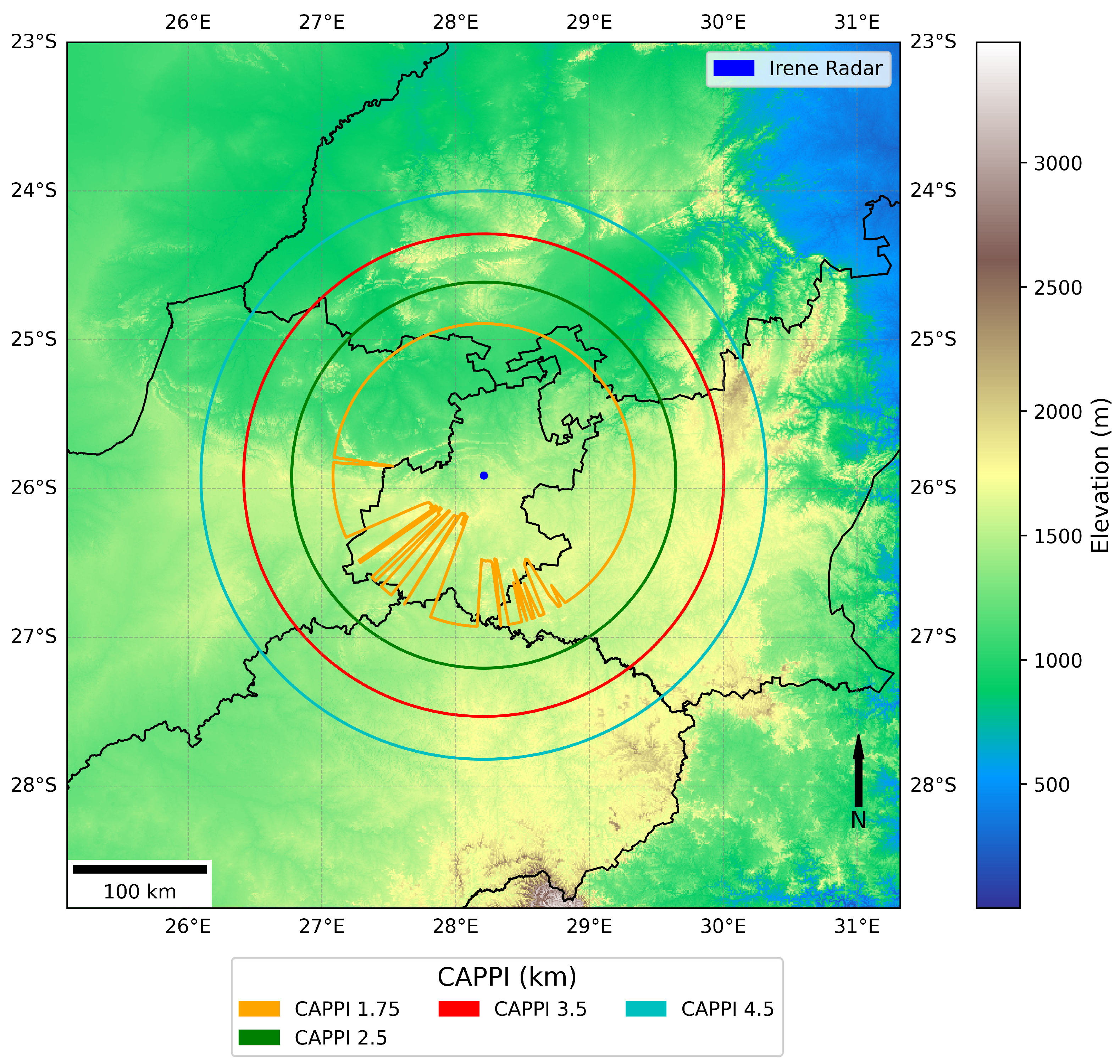
The South African Weather Service (SAWS) operates an S-band radar (2.7 GHz) located in Irene (25.91° S, 28.21° E), Pretoria, at 1560 m above mean sea level (
Figure 2). The radar, with a range of 200 km, covers the major metropolitan areas of Gauteng, including Pretoria, Johannesburg, and parts of the North West, Mpumalanga, Free State and Limpopo provinces. This single polarised radar with Doppler capability operates at a pulse repetition frequency (PRF) of 500 to 1200 Hz with a pulse width of 0.85–1.64 µs. A volume scan is completed at twelve elevation angles, from 0.5° to 30°, while rotating 1° in azimuth in ±360 s (6 min), with an antenna speed of 30°/s at higher elevations and 10°/s at lower elevations [
22]. More information on the scanning strategy and radar specifications can be found in the study of Becker (2014) [
22].
This study used historical data from 2013 to 2016, obtained from SAWS, to validate the methodology. No significant changes in radar calibration were reported during this period. SAWS applies a standard clutter removal algorithm from the Lidar Radar Open Software Environment (LROSE) (created by Mike Dixon and NCAR/EOL, Boulder, CO, USA) which identifies stationary targets by their backscattered reflectivity from radar scans on clear, dry days without weather [
23].
Radar beam blockage from topographical features can impede the ability to observe aerosol plumes. To ensure optimal plume detection, the beam blockage fraction was estimated using a high-resolution Digital Elevation Model (DEM) and standard beam refraction [
24]. Specifically, a 30 m DEM from the Shuttle Radar Topography Mission (SRTM) and a 2D Gaussian distribution of beam illumination were used to estimate the fraction of beam blockage at each radar radial for a given elevation scan.
To avoid losing information from ground clutter interference while ensuring sufficient coverage of the plumes, this study utilised interpolated data at a constant altitude, known as the Constant Altitude Plan Position Indicator (CAPPI). Data close to the radar are derived from the higher elevation angles, which reduces the effect of ground clutter observed by the lowest elevation scan.
Figure 2 shows the beam blockage at four CAPPI levels alongside the DEM. Partial beam blockage occurs south and southeast of the radar at 1.75 km CAPPI, while no blockage occurs in the northern and northeastern regions of the radar volume. All CAPPI levels above 1.75 km are free from topographical clutter. Therefore, this study used reflectivity data at these CAPPI levels. However, the disadvantage of CAPPI data includes a limited range at the lower levels. Higher CAPPI levels are required to include data in further ranges, but data at higher elevations were excluded from the analysis due to beam propagation properties. As shown in
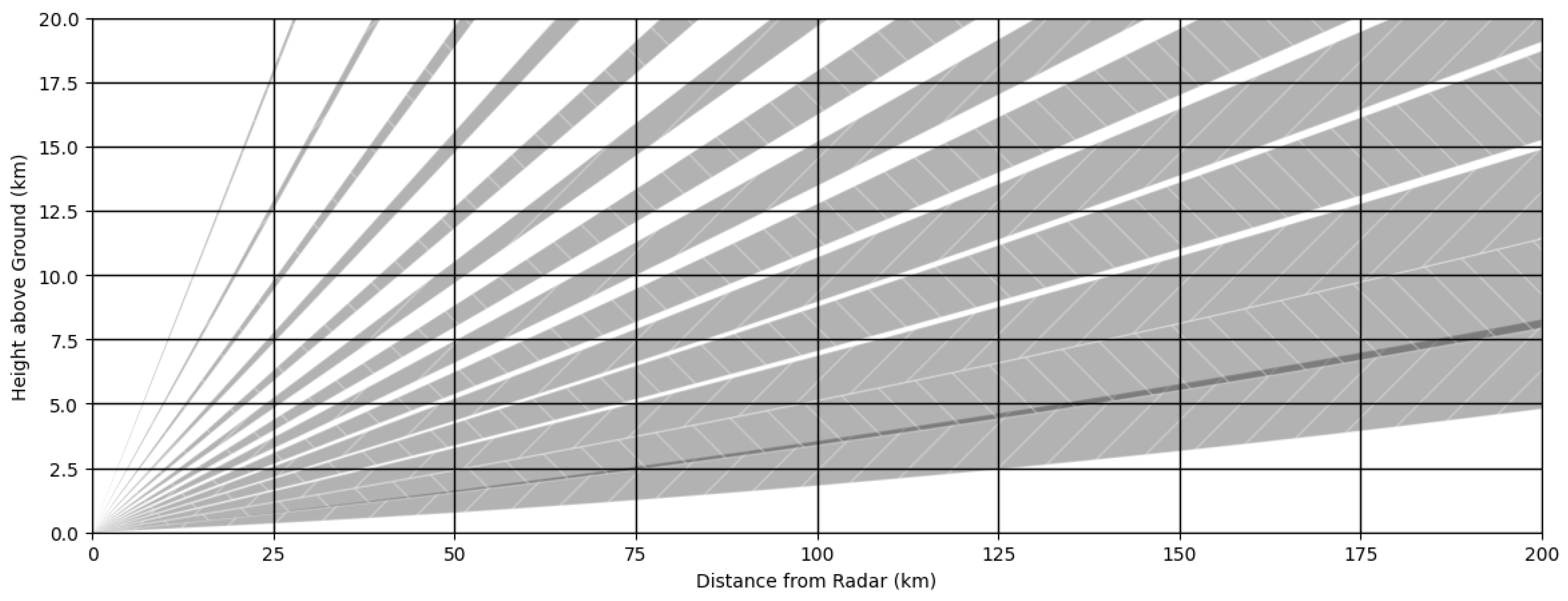
Figure 3, the beam height increases with distance from the radar at higher elevations, as a function of the curvature of the earth and atmospheric density. Beams at higher elevations therefore overshoot plume events given the typical vertical structure of plumes, which are discussed in the following sections.
2.2. Clutter Removal
Traditional clutter removal algorithms focus on removing non-meteorological targets from the sampling volume. However, in this study, meteorological echoes (i.e., clouds and storms) are regarded as clutter, since the focus is on detecting aerosol plumes. Radar data from days with clouds and other meteorological targets were removed to ensure that the reflectivity measurements used were solely from plumes.
This was achieved by visually inspecting atmospheric conditions in the sample volume with true-colour-corrected surface reflectance imagery from the Visible Infrared Imaging Radiometer Suite (VIIRS) and Moderate Resolution Imaging Spectroradiometer (MODIS) sensors on board the National Oceanic and Atmospheric Administration (NOAA) Aqua and Terra satellites [
25]. A cloud mask from the Spinning Enhanced Visible InfraRed Imager (SEVIRI) on board the Meteosat Second Generation (MSG) geostationary satellite was also used to confirm visual observations of cloud presence and absence [
26]. The cloud mask provides pixel-level information on cloud occurrence, with pixels classified as cloudless sky over land, cloudless sky over water, cloud, or not processed [
26]. The days on which clouds occurred in the Highveld area were removed to ensure that reflectivity from clear days was used.
2.3. Plume Tracking
The TITAN algorithm [
23] was developed in 1984 during the Programme to Augment Water Supplies (PAWS) cloud seeding programme in Nelspruit, South Africa [
23,
27]. Initially used to evaluate rainfall enhancement experiments, TITAN evolved to focus on the tracking and nowcasting of thunderstorms [
27]. Contributions from different institutions and organisations have expanded TITAN into a comprehensive system that includes various layers of infrastructure, algorithms, and data processing applications, now widely recognised as LROSE [
28,
29].
The TITAN algorithm automatically identifies, tracks, and forecasts convective storms using radar reflectivity measurements, defining storms as three-dimensional regions where reflectivity values exceed a predetermined threshold and exceed a specified volume threshold [
23,
27]. Storm tracking involves matching storms across consecutive radar scans using combinatorial optimisation techniques to determine optimal storm paths [
30]. This is achieved by minimising a cost function that incorporates volume- and distance-weighted differentials for each trajectory [
23,
30]. Before optimisation, an overlapping technique aids in storm matching. The algorithm accommodates dynamic storm behaviours, such as merging, where a single identified storm corresponds to multiple storms in the previous image, and splitting, where multiple identified storms correlate to a single storm in the previous image [
23,
30].
A complete trajectory of a storm, from formation to decay, including interactions, is referred to as a track and is assigned a unique identification number. Tracks are categorised as complex or simple based on whether they involve interactions. Each segment of a complex track between interactions is associated with a secondary identification number.
For this study, the TITAN algorithm was adapted to track aerosol plumes. Smoke plumes, characterised by lower reflectivity and cloud top heights compared with storms, require specific adjustments to avoid misclassification. False tracks from Radio Local Area Networks (RLANs) interference, ground clutter, beam blockage, and small polygons are filtered out. Tracks are stored in .th5 format and converted to XML using the Tstorms2XML function in the LROSE software suite (Version lrose-core-20220222, created by Mike Dixon and NCAR/EOL, Boulder, CO, USA). TITAN produces plume track vertices, simple and complex track IDs, area in km2, base height (km), top height (km), and maximum dBZ. The vertices are used to construct polygons, which are aggregated and filtered for analysis.
2.4. Parameter Optimisation
To effectively identify and track aerosol plumes using the TITAN algorithm, certain parameters are adjusted and optimised. The reflectivity threshold serves as the primary parameter that influences the detection of the plume. A lower reflectivity threshold, as employed with a 7 dBZ lower and 75 dBZ upper threshold in this study, enhances sensitivity to larger plume areas but concurrently increases susceptibility to false echoes. Conversely, a higher threshold would prioritise the identification of smaller spatial extents with denser aerosol concentrations within plumes.
In addition to the reflectivity threshold, defining parameters such as the top limits of the plume and the maximum height to calculate the column reflectivity (max dBZ) are instrumental in the identification and tracking accuracy of the plume. Plumes typically exhibit lower top heights compared to storms, which required a restricted plume top of 20 km in this study. Similarly, the maximum height for computing the maximum dBZ is constrained to 20 km.
2.5. Ambient Data
Ambient air quality data from surface monitoring stations in the Highveld region that fall within the maximum detectable radar range were collected from the South African Air Quality Information System (SAAQIS). These stations measure particulate matter (PM10 and PM2.5) concentrations at hourly intervals, providing real-time information on surface air quality during plume events. Data were used to assess the temporal correlation between radar-detected plumes and observed increases in particulate matter concentrations at ground level. Ambient data serve as an important validation tool to assess whether radar-detected plumes were associated with significant air quality events.
2.6. Satellite Data
Satellite observations were integral to the validation of the radar-based methodology for detecting and tracking aerosol plumes. True-colour-corrected surface reflectance imagery from VIIRS and MODIS was used to visually assess atmospheric conditions within the radar sample volume, and to confirm plume occurance. In addition, VIIRS-derived thermal anomalies were used to verify the occurrence of heat sources, such as biomass burning events, which are the primary contributors to aerosol plume generation. These thermal anomalies provided an additional layer of validation for plume tracking in instances of identified aerosol events.
2.7. Case Studies and Data Availability
The validation of the radar-based plume detection methodology was based on specific case studies from June and August 2013. These case studies were chosen based on the availability of data from three critical platforms: radar, surface air quality monitoring stations, and satellite observations (VIIRS, MODIS, and SEVIRI). The simultaneous availability of these data allowed for a comprehensive validation of the radar-derived plume characteristics against surface observations and satellite imagery.
However, the limited number of case studies in this analysis is due to the challenges of acquiring complete datasets across all three platforms. Although numerous plumes were detected and tracked using radar, many of these events lacked corresponding satellite coverage, further restricting the number of suitable plume events for validation. The need for concurrent radar, satellite, and air quality data therefore limited the available cases. As such, this study focusses on the cases in which all required datasets were available, ensuring the robustness of the validation process despite the limited sample size.
4. Discussion
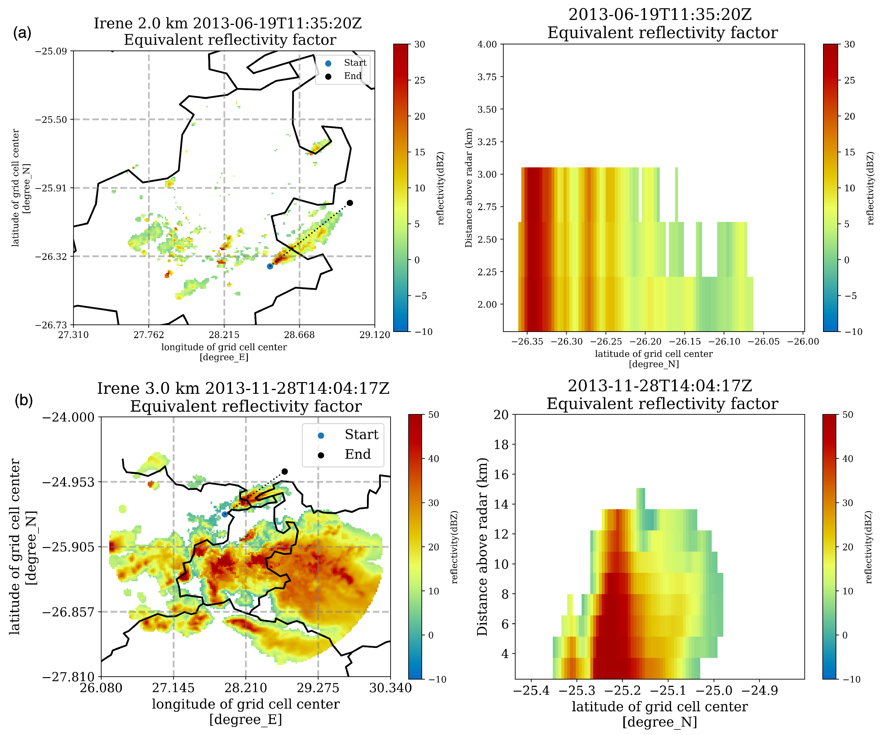
The results presented support the validation of the radar-based methodology developed for detecting and characterising aerosol plumes from non-industrial sources, in several key aspects. First, the ability of weather radar to distinguish aerosol plumes from meteorological phenomena is clearly demonstrated. As shown in
Figure 4, the radar detection of a plume on 19 June 2013 contrasts with the severe storm event of 28 November 2013. The lower reflectivity values and distinct vertical profiles associated with the plume event validate the radar’s sensitivity in differentiating between convective weather echoes and aerosol plumes.
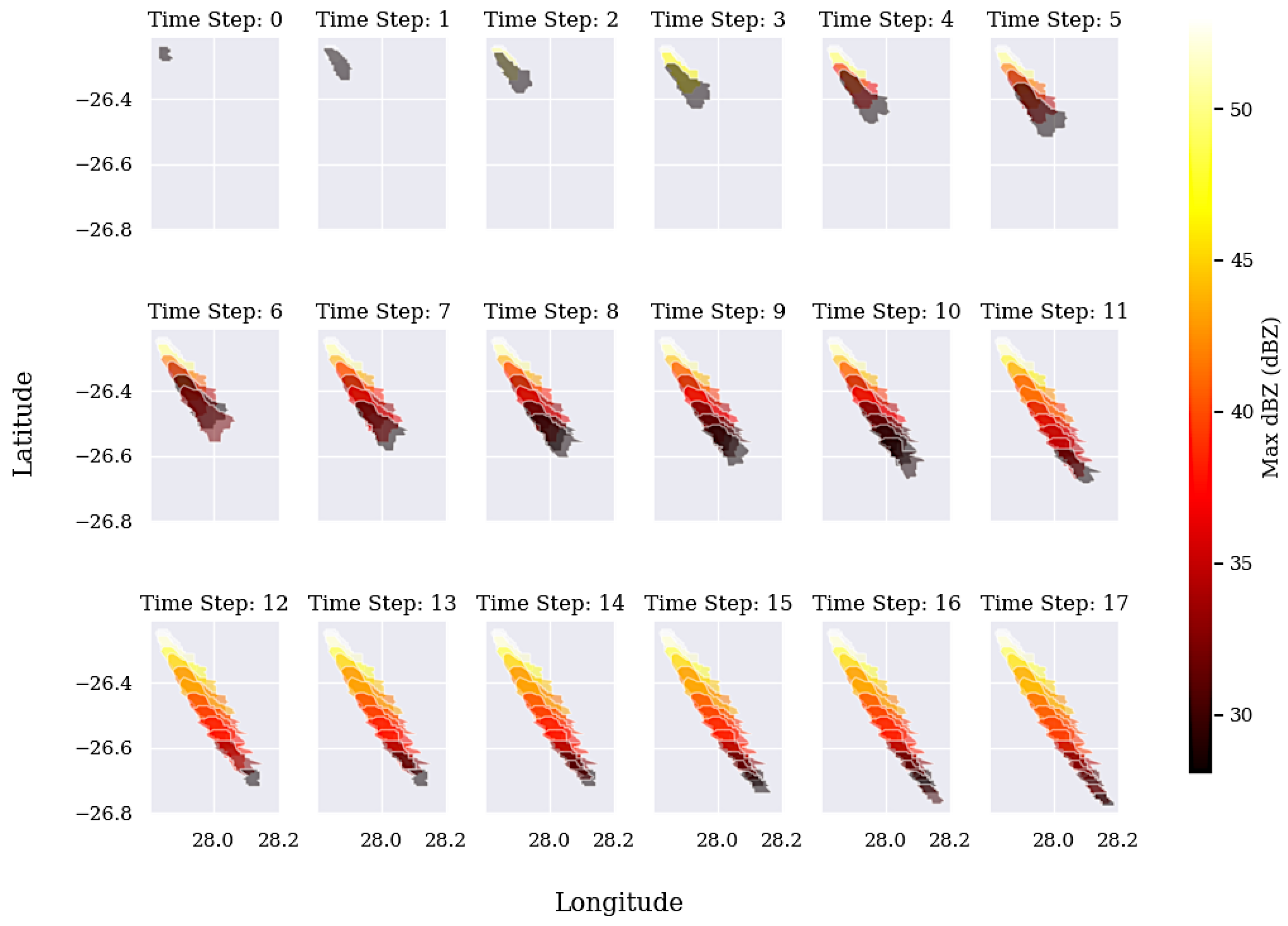
Second, the methodology validates the use of radar in studying the spatial and temporal properties of aerosol plumes. The real-time monitoring capability of the radar and the use of TITAN enables for spatial time series analysis among others. With the radar’s capability to detect individual plume tracks and other variables such as dBZ and plume top height, it is possible to investigate plume growth dynamics in detail. An example of this is presented in
Figure 7, where the growth of the plume event over time is tracked at 5 min intervals. This level of temporal resolution is essential in regions where rapid aerosol dispersion can affect air quality across multiple locations in short timeframes, providing air quality managers with timely and actionable data.
In addition to reflectivity observations, the use of Doppler radial velocity data presents an opportunity to further enhance the analysis of plume transport dynamics. Although this study did not focus on radial velocity measurements, they have the potential to assess the transport speed and three-dimensional motion of plumes. Such data could provide valuable insights into the internal velocity structure of the plume, complementing reflectivity-based characterisations of plume size and dispersion. Future studies could benefit from integrating radial velocity information to deepen our understanding of aerosol plume behaviour, particularly with respect to plume evolution, turbulence, and the interaction with surrounding meteorological phenomena.
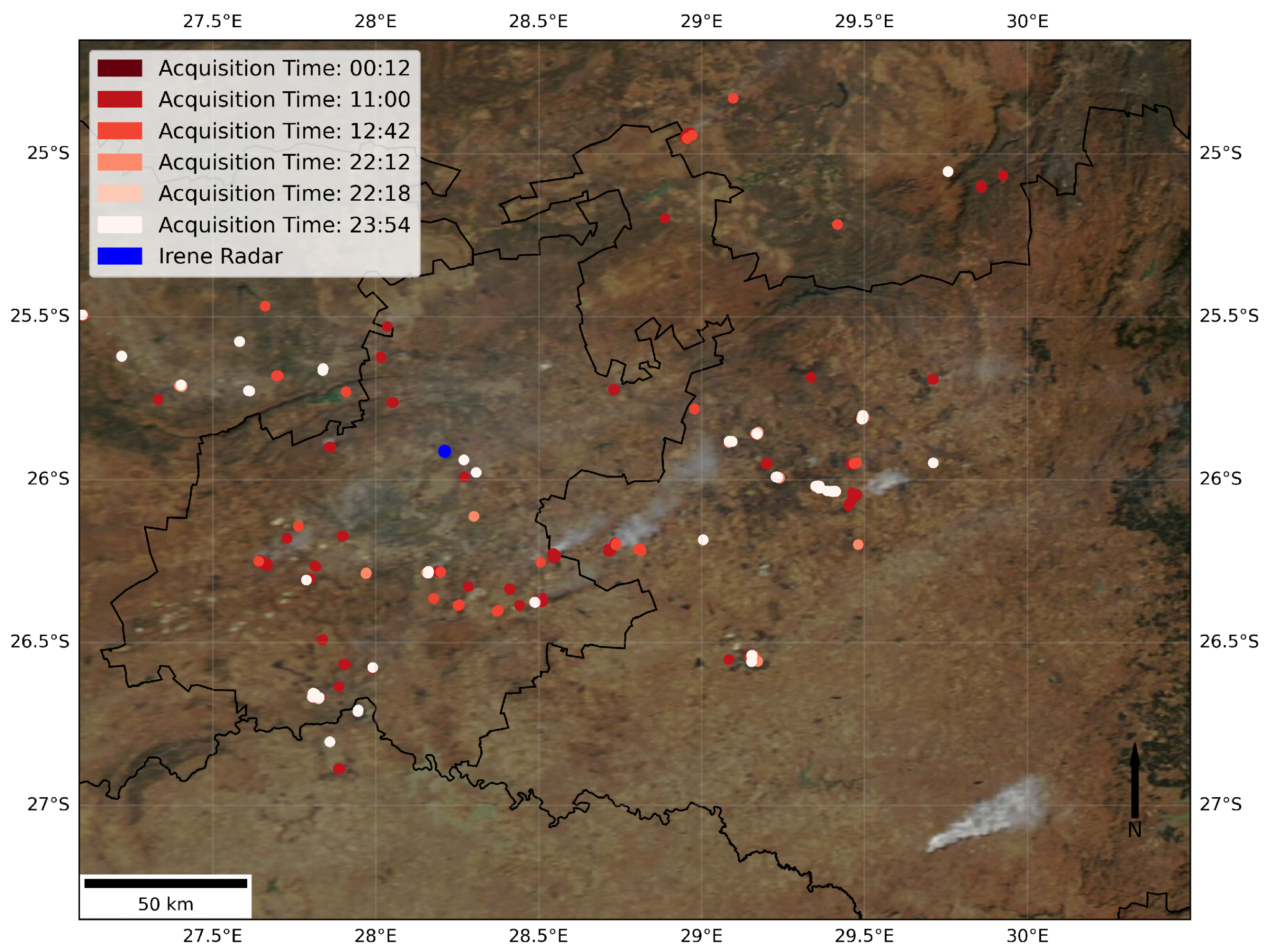
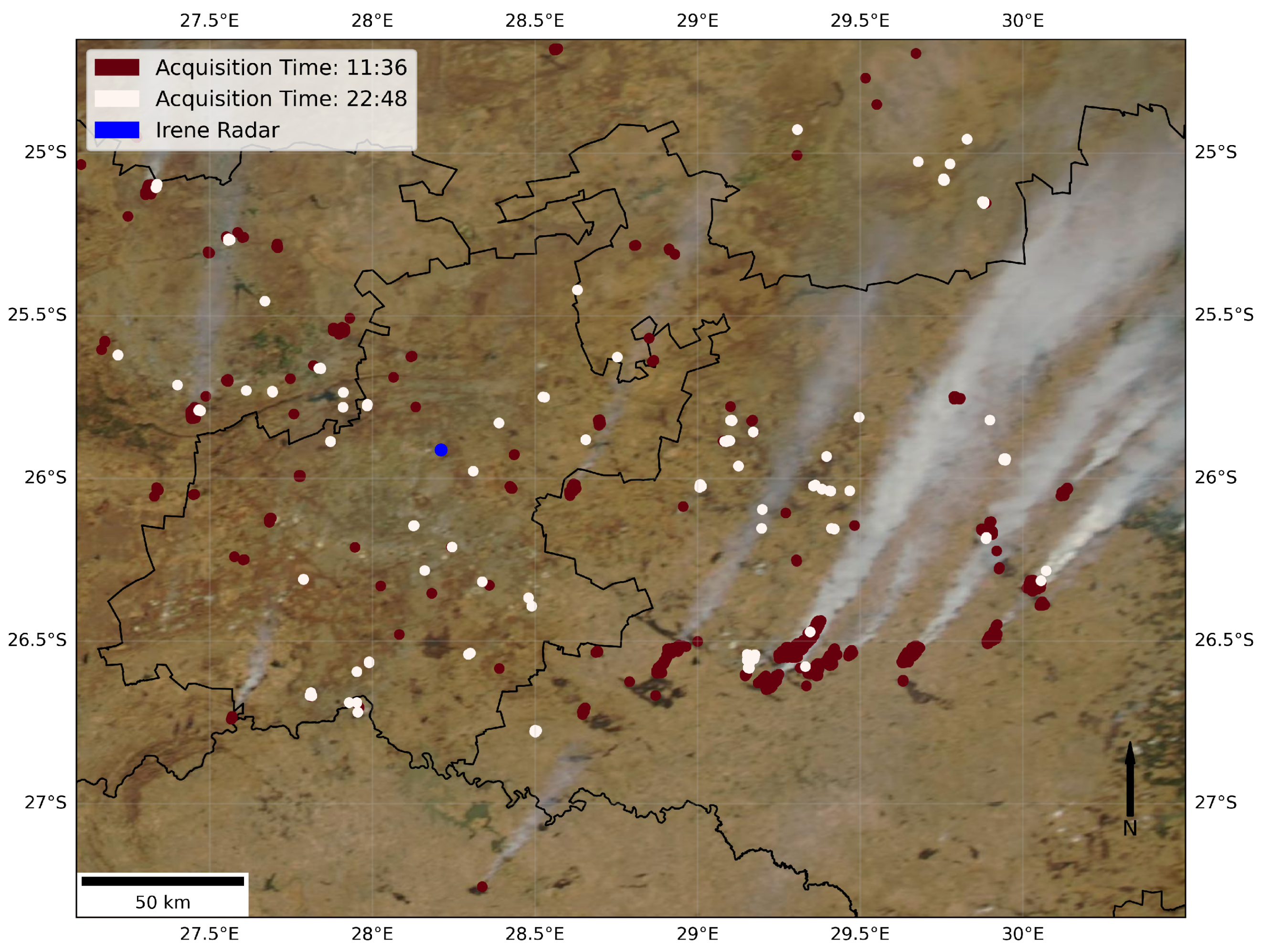
In addition, the comparison with satellite data highlights the complementary role of weather radar in plume detection. Radar-detected plume events not visible in satellite imagery, as shown in
Figure 5, underscore the sensitivity and temporal resolution of the radar. This finding is significant because it demonstrates that radar can identify plumes under conditions where satellite detection is limited, due to atmospheric interference or low aerosol concentrations. In contrast, satellite data from the 29 August 2014 event (
Figure 6) show large plumes outside of the radar operational range, reinforcing the need for an integrated approach to utilise multi-platform data for a comprehensive understanding of plume distribution.
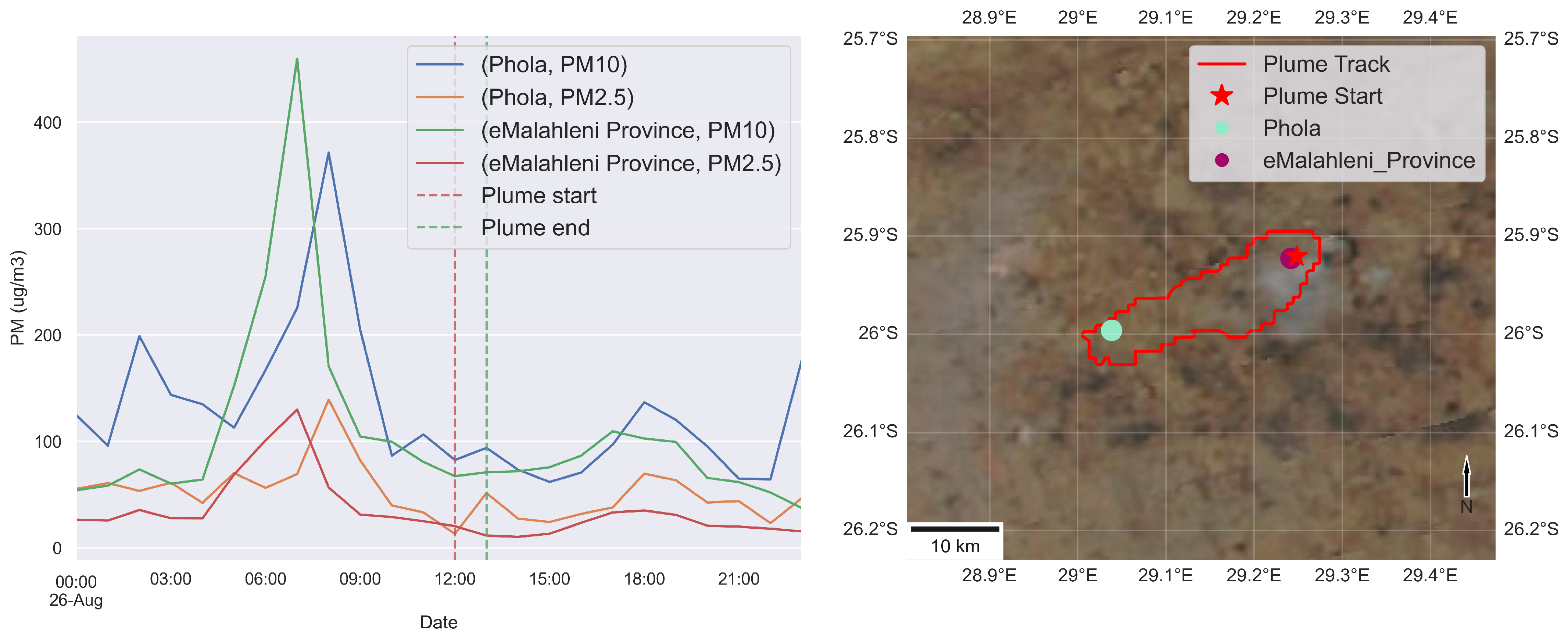
In addition, this study illustrates the potential of radar to assess the impacts of plume on air quality. The comparison between radar-detected plume events and elevated PM concentrations at ground stations, as shown in
Figure 8, confirms that radar data can identify plume-driven air pollution events. The observed increase in PM concentrations during the 26 August 2016 plume event at the Phola monitoring station supports the hypothesis that radar-derived plume data improve the identification of sources contributing to ground-level air quality issues. The influence of plume characteristics, such as proximity, area, and lifetime, on PM levels is critical to understanding air quality dynamics, as is the interaction with prevailing atmospheric conditions such as temperature inversions, wind patterns, and humidity.
Furthermore, it is important to acknowledge that fluctuations in ground-level PM concentrations can also be a result of localised pollution sources and variable meteorological conditions. Thus, attribution of observed increases in PM concentrations exclusively to plume events can oversimplify the multifaceted nature of air quality dynamics. However, the analysis demonstrates that radar can derive crucial information on the spatial and temporal characteristics of aerosol plumes, offering valuable insights into their impact on air quality.
5. Conclusions
In conclusion, this study demonstrates the effectiveness of weather radar as a powerful tool for the real-time monitoring of aerosol plumes, providing critical insights into their spatio-temporal dynamics and impacts on air quality. The developed radar-based methodology successfully detects and characterises plumes from non-industrial sources, such as biomass burning, utilising existing radar infrastructure and routine satellite observations for enhanced air quality management. By showcasing the dual-purpose utility of these systems, this research offers a practical framework for regions with limited resources, illustrating that an infrastructure designed for meteorological observations can also contribute significantly to air quality assessment and management. This innovative approach fills data gaps and supports effective decision making in air quality improvement strategies.
Key findings reveal that radar detects plume events with a higher temporal resolution than satellites, especially in conditions where satellite detection is constrained, such as low aerosol concentrations or atmospheric interference. The integration of radar data with satellite and ground-based air quality monitoring systems enables a comprehensive monitoring framework that enhances the understanding of plume behaviour and its influence on ground-level PM concentrations. For example, the 26 August 2016 plume event in Mpumalanga province illustrates the relationship between radar-derived data and elevated ground-level PM concentrations, underscoring radar’s potential to inform real-time air quality management, particularly in regions like the Highveld.
Although integrating radar data poses challenges, such as interference from meteorological targets during convective storms, these can be addressed by corroborating radar observations with satellite data and air quality monitoring system measurements. The predominance of dry conditions during the South African winter fire season further emphasises the utility of radar in these periods, when rainfall is minimal.
Future research should focus on refining plume detection algorithms and expanding this methodology to other regions and plume types. Using advances in radar technology and improved data integration methods can improve the accuracy of plume detection, ultimately contributing to more effective air quality management and policy development.

