Article

Trends in Nighttime Fires in South/Southeast Asian Countries

1
NASA Marshall Space Flight Center, Huntsville, AL 35812, USA
2
Department of Atmospheric and Earth Science, The University of Alabama in Huntsville, Huntsville, AL 35899, USA
*
Author to whom correspondence should be addressed.
Atmosphere 2024, 15(1), 85; https://doi.org/10.3390/atmos15010085
Submission received: 4 November 2023 / Revised: 28 December 2023 / Accepted: 4 January 2024 / Published: 9 January 2024
(This article belongs to the Special Issue Wildland Fire under Changing Climate (2nd Volume))

Abstract

:
Quantifying spatial variations and trends in nighttime fires is crucial for a comprehensive understanding of fire dynamics. Traditional fire monitoring typically focuses on daytime observations, but controlling nocturnal fires poses unique challenges due to reduced visibility. While several studies have focused on examining global and regional fire trends, very few studies have focused on nighttime fires, particularly in South/Southeast Asian (S/SEA) countries. In this study, we analyzed nighttime vegetation fires in S/SEA using VIIRS I-band (375 m) data, including a comparison with Sentinel-3A SLSTR data. The results suggested that ~28.25% of total fires occurred at night in SA, and 18.98% in SEA. In SA, a statistically significant (p =< 0.05) increase in nighttime fires was observed in Bangladesh. India showed a positive trend in nighttime fires, while Nepal, Pakistan, and Sri Lanka exhibited negative trends; however, these results were not statistically significant. In SEA, we detected statistically significant (p =< 0.05) decreases in nighttime fires in Cambodia, Indonesia, Malaysia, and Vietnam, with increases in Myanmar and the Philippines. Indonesia experienced the most substantial reduction in nighttime fires. Furthermore, VIIRS I-band detections were approximately 92–98 times higher than those of SLSTR-3A in S/SEA. Overall, our study offers valuable insights into nighttime fires and trends in S/SEA countries, which are useful for fire prevention, mitigation and management in the region.

1. Introduction

Vegetation fires in Asia are recurrent events that primarily occur during the dry season. The drivers of these fires include both the climate and anthropogenic factors [1,2]. In several Asian countries, fires are deliberately set for land clearance through practices such as slash-and-burn in forests and the clearing of agricultural residues after harvest [3,4]. The burning of biomasses from these activities contributes significantly to greenhouse gas emissions and aerosols [5]. Moreover, these fires release substantial amounts of particulate matter (PM) and other pollutants into the atmosphere, which can be transported over long distances, impacting local and regional air quality and public health [6,7,8]. Aside from the atmospheric emissions, the adverse effects of these fires on landscapes encompass the loss of forest ecosystems that support biodiversity and ecosystem services, such as timber, nutrient cycling, and water retention [9]. Continuous burning leads to a depletion of soil fertility [6,10]. While some researchers have reported positive aspects of fires, such as the availability of nutrients for subsequent crops, especially in slash-and-burn ecosystems [11], the long-term and short fallow periods can negatively impact nutrient regeneration [12]. Fires can also influence the regrowth of new vegetation, affecting its type, structure, and composition, thereby impacting ecological processes [13]. Thus, quantifying the spatial and temporal variations in fires can provide insights into their ecological and environmental impacts [14].
Monitoring fires over large areas poses a considerable challenge, even though ground-based methods are effective on smaller spatial scales. To address this challenge, remote sensing technologies have become widely utilized in the detection, mapping, and monitoring of fires. These technologies provide capabilities for multi-temporal, multi-spectral, synoptic, and repetitive coverage. Leveraging remote sensing data allows us to gather valuable information regarding fire occurrences, the extent of burnt areas, and their impact on ecosystems [15,16]. Remote sensing satellites primarily employ optical sensors that utilize reflected sunlight to characterize Earth’s surfaces. The author of [17] provides a summary of operational satellite remote sensing fire products, while [18] provide a review of fire detection algorithms. Over the past few decades, a diverse array of sensors has been employed for fire detection and monitoring, including the Advanced Very-High-Resolution Radiometer (AVHRR) [19], the Defense Meteorological Satellite Program (DMSP) Operational Linescan System [20], the Along-Track Scanning Radiometer (ATSR) [21], the Visible and Infrared Scanner (VIRS) [22], the Moderate Resolution Imaging Spectroradiometer (MODIS) [23], the Visible Infrared Imaging Radiometer Suite (VIIRS) [24,25], the Geostationary Operational Environmental Satellite (GOES) Imager [26], the Spinning Enhanced Visible and Infrared Imager (SEVIRI) [18], and Himawari [27], among others. Fire detection relies on two fundamental laws: Planck’s law and Wien’s displacement law. Flaming fires emit peak thermal radiant energy at shorter wavelengths (Planck’s law). Furthermore, the temperature curve’s peak shifts to different wavelengths based on the fire’s intensity (Wien’s law). In the visible spectrum, smoke mainly obstructs fire retrievals, whereas the strong infrared signal emitted by flaming fires can be readily captured in the middle-infrared (MIR) portion of the spectrum. In the MIR wavelength range, the spectral radiance emitted by flaming fires can be up to four orders of magnitude greater than the surrounding ambient background, resulting in a significant signal increase. Therefore, MIR channels are predominantly used for active fire detection [28,29]. Additionally, for a given increase in temperature, the radiation in the MIR channel increases more rapidly than that in the thermal infrared (TIR) channel. During the night, when solar interference is absent due to high-albedo surface features, specific algorithms for nighttime fire detection have been demonstrated using short-wave infrared (SWIR) bands centered around 1.6 μm [30] and visible-light bands centered around 0.7 μm [31] using VIIRS on the Suomi National Polar-orbiting Partnership (S-NPP) satellite.
While there are several studies examining fire trends on a global and regional scale, there is a limited focus on nighttime fires, particularly in South/Southeast Asian countries. For instance, in the study by the authors of [32], which utilized MODIS active fire data, it was reported that on an annual basis, 10.4% (with a standard deviation of ±0.9%) of global fire detections during 2003–2020 occurred during nighttime hours. The percentage of detected fires at nighttime varied from 5% to 38% across different burnable land cover types. Nighttime fire detections were most prevalent in temperate evergreen needleleaf forests, where 38% of detections occurred at night. In contrast, cropland fires predominantly happened during daytime hours, with 89–95% of active fire detections occurring during the day across equatorial, arid, temperate, and boreal croplands. Generally, the fire radiative power (FRP) was lower at night, except for boreal grasslands, accounting for 52–97% of daytime FRP/detection, depending on the land cover type. However, the study did not provide a country-wide analysis of nighttime fires. The objective of our study was to assess variations in nighttime fires in South/Southeast Asian countries using satellite remote sensing data. We compared VIIRS and Sentinel-3A SLSTR data to analyze monthly and yearly nighttime variations. We also used VIIRS data to identify trends of increase or decrease in nighttime fires. The results offer insights into nighttime fire trends at the country level, which can be valuable for fire management.

2. Materials and Methods

2.1. VIIRS Data

In this study, we used the Suomi National Polar-orbiting Partnership (Suomi NPP) Visible Infrared Imaging Radiometer Suite (VIIRS) I-band 375 m active fire product (VNP14IMG) for the analysis. VIIRS is a remote sensing instrument flying on the S-NPP and NOAA-20 (JPSS-1) satellite platforms. VIIRS has 22 channels, with a nominal spatial resolution of 375 m in the 5 imagery bands (I-bands) and 750 m in 16 moderate-resolution bands (M-bands), covering a spectral range from 0.412 μm to 12.01 μm. The VIIRS instrument includes two distinct sets of multi-spectral channels, offering complete worldwide coverage at nominal resolutions of 375 m and 750 m every 12 h or less, depending on the latitude. The VIIRS satellite has fire-sensitive channels, including a dual-gain, high-saturation-temperature 4 µm channel which can be used for detecting active fires. Two different fire products are available from VIIRS, one based on 375 m (I-bands) and the other on the 750 m moderate-resolution “M” bands [25]. The VNP14IMG builds on the well-established MODIS fire and thermal anomalies product using a contextual approach to detect thermal anomalies [25]. The Suomi VIIRS I-band active fires data at 375 m use 0.64, 0.86, and 1.6 μm bands to detect both day and night fires including fire radiative power (FRP) [25]. The FRP in VNP14IMG is computed by utilizing data from both VIIRS 375 m and 750 m. The 375 m data are employed to recognize clouds affected by fire (solid blue), water (dashed blue), and valid background pixels. Subsequently, the FRP calculation involves utilizing co-located M13 channel radiance data (750 m) corresponding to both fire pixels and valid background pixels. In contrast to other coarser-resolution (≥1 km) satellite fire detection products such as MODIS, the improved 375 m data provide greater response over fires of relatively small areas, as well as improved mapping of large fire perimeters [25]. Thus, the data are well suited for use in support of fire management, including other science applications.

2.2. SLSTR Data

Sentinel-3 Sea and Land Surface Temperature Radiometer (SLSTR) is an operational mission that is part of the Copernicus program, which launched in 2016, and it is a dual-scan temperature radiometer in the low Earth orbit (800–830 km altitude) on board the S3 satellite. Currently there are two instruments in orbit, Sentinel-3A and Sentinel-3B satellites. The two SLSTRs provide observations that are useful for active fire detection and FRP retrieval across the visible-to-long-wave infrared spectral range at equatorial nadir local solar times of ~10:00 a.m. and ~10:00 p.m. [33]. The mean global-coverage revisit time for dual-view SLSTR observations is 1.9 days at the equator (ESA Sentinel online, 2020). SLSTR employs the along-track scanning dual-view (nadir and backward oblique) technique for 9 channels in the visible (VIS), thermal infrared (TIR), and shortwave infrared (SWIR) spectra. It also provides two dedicated channels for fire and high-temperature event monitoring at 1 km resolution from the dynamic range of the 3.74 μm channel and including dedicated detectors at 10.85 μm that are capable of detecting fires at ~650 K without saturation. The Sentinel-3 World Fire Atlas was developed by the European Space Agency, processing the Sentinel-3A SLSTR Level 1b data and containing two dedicated channels (F1 and F2) for fire and high-temperature events at a global scale during nighttime. The algorithm for fire detection is based on [34], and the details of the specific product can be found at https://s3wfa.esa.int/. More details about the Sentinel-3 SLSTR can be found at the following link: (https://sentinel.esa.int/web/sentinel/user-guides/sentinel-3-slstr) In this study, we compared the nighttime fires from this product with the VIIRS I-band (375 m) product.

2.3. Statistical Analysis
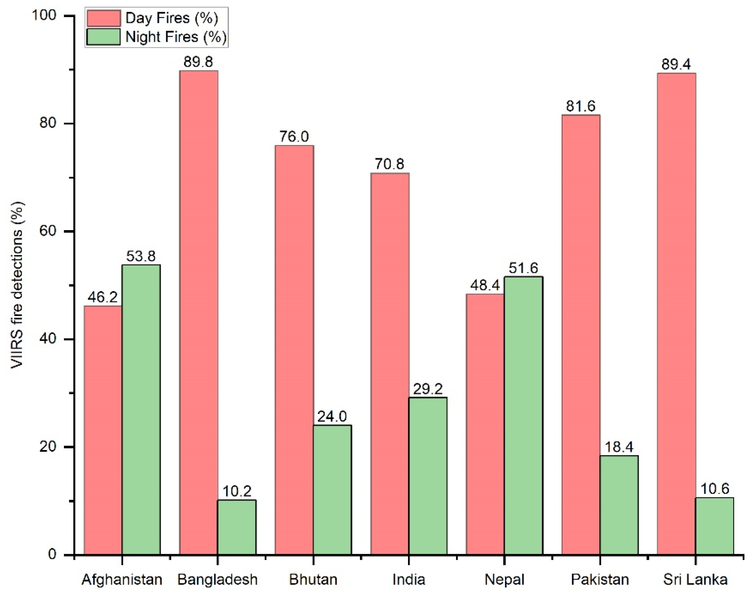
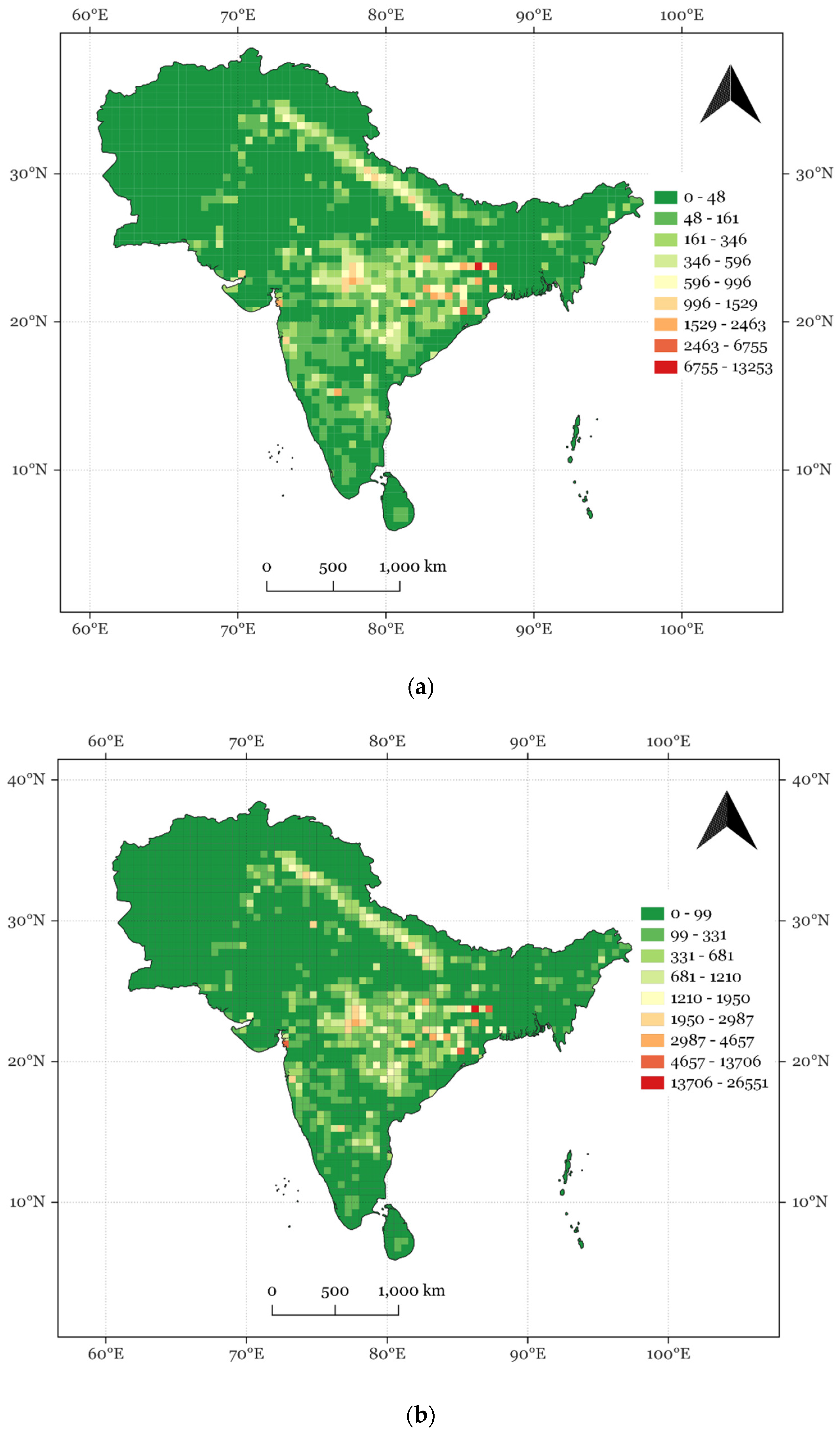
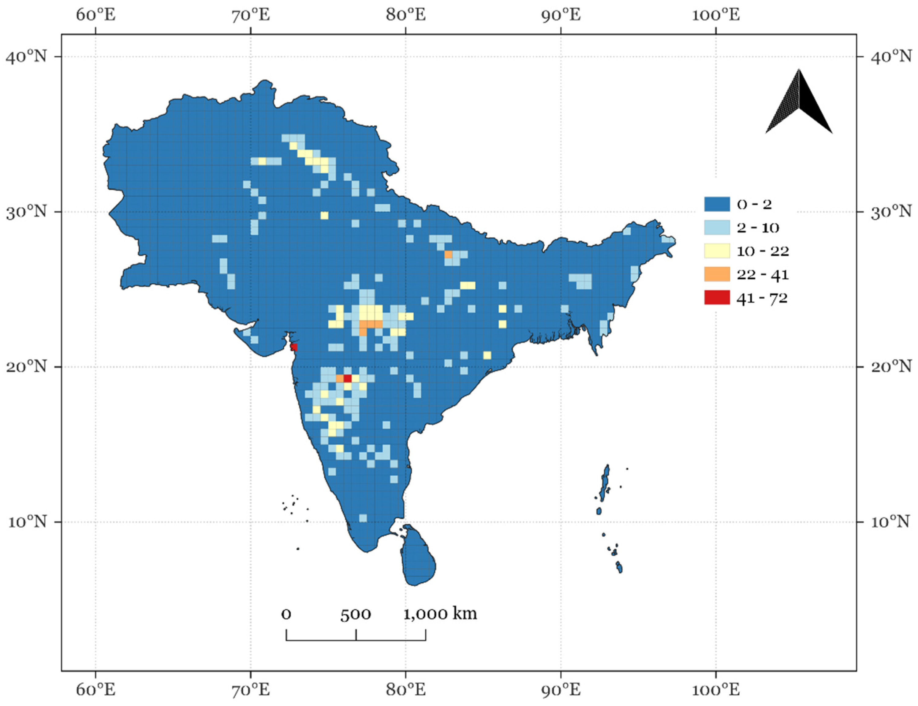
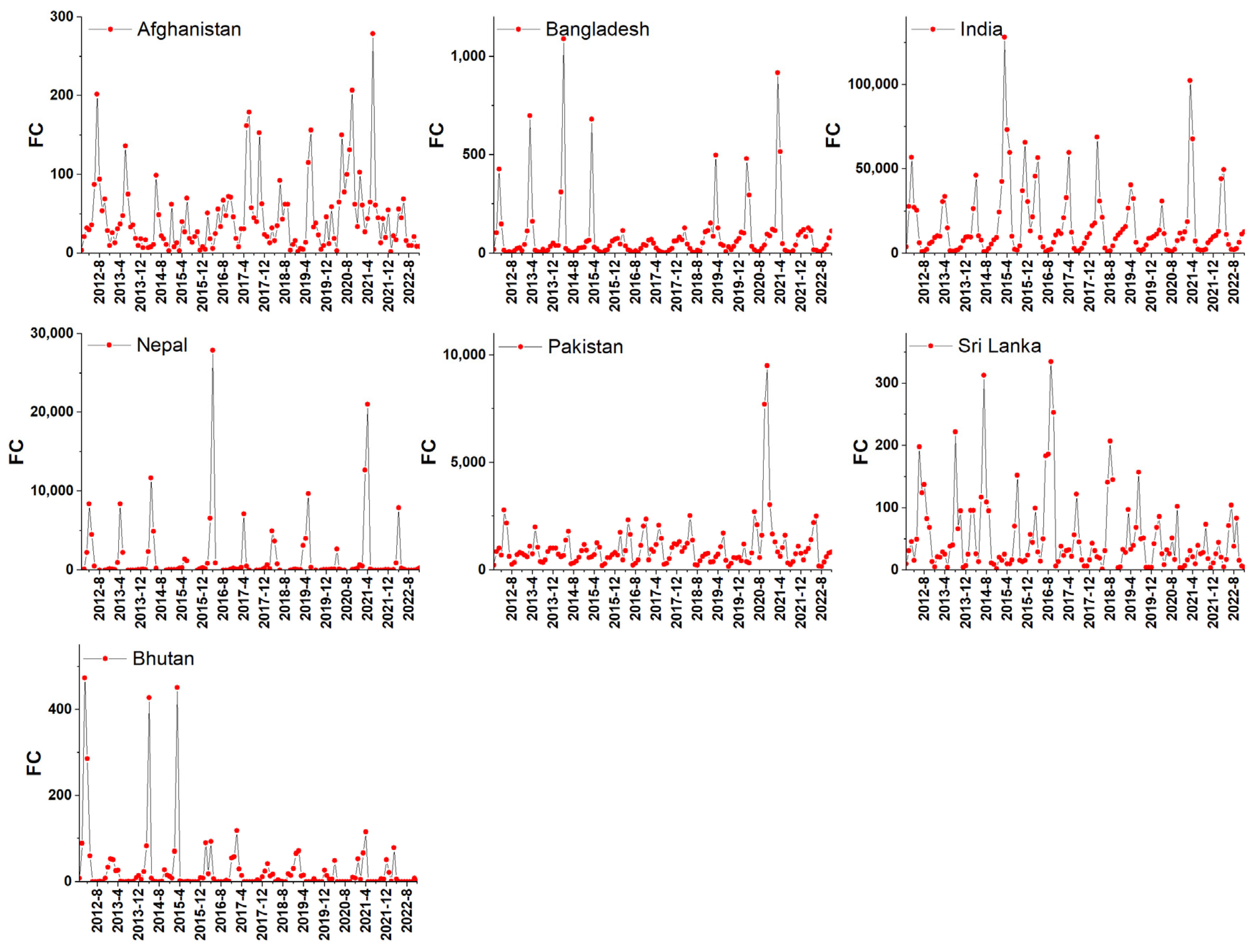
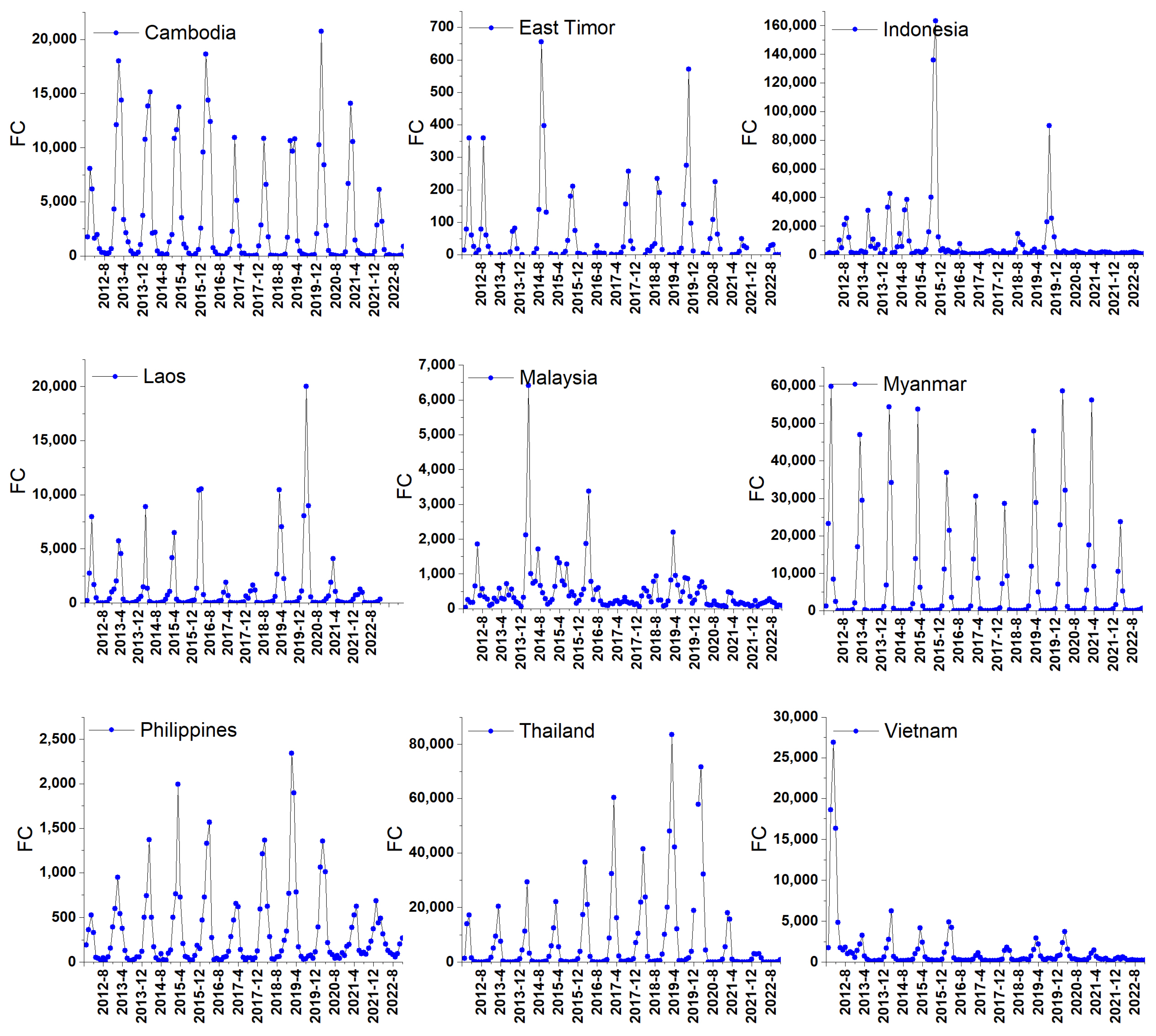
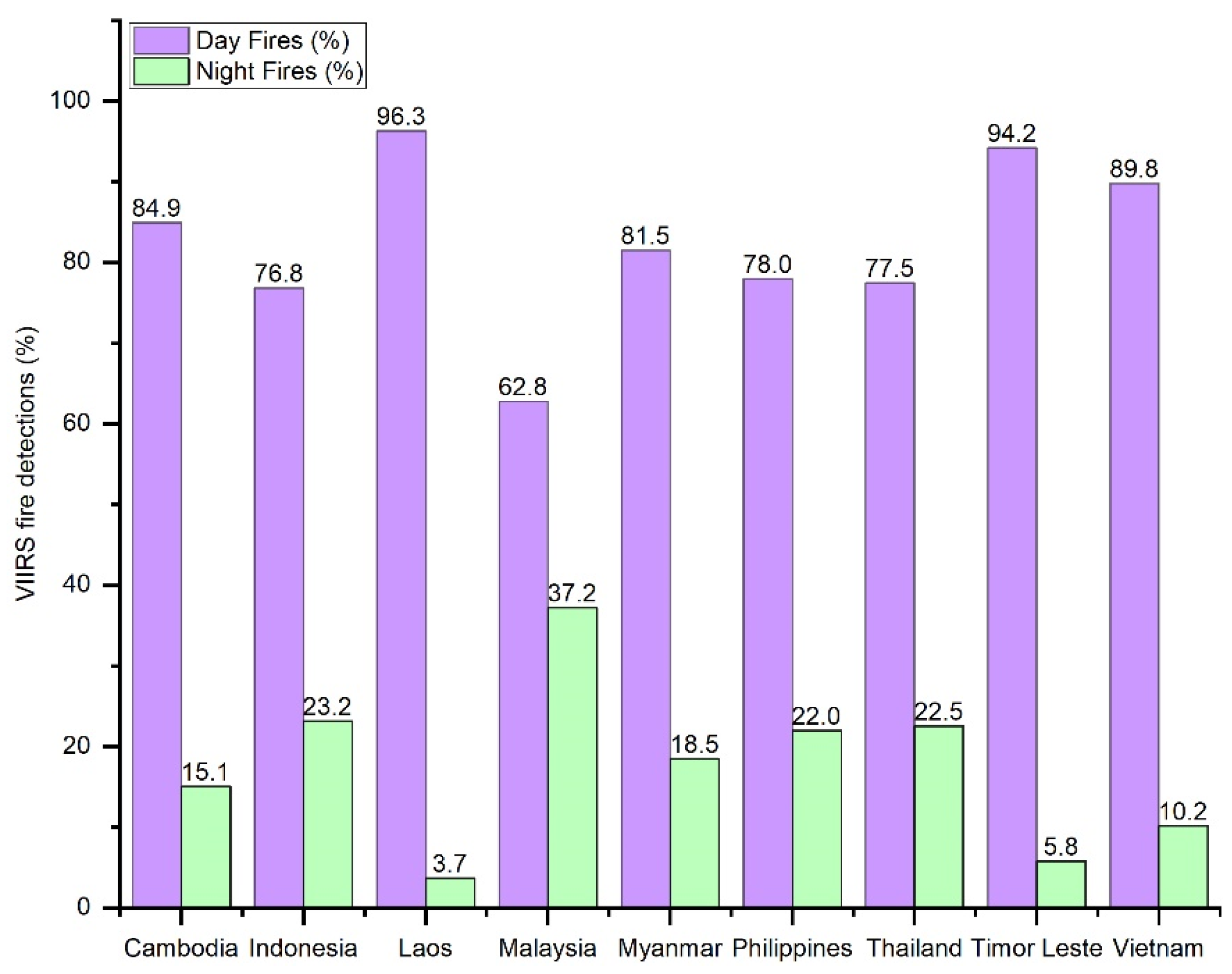
We extracted monthly nighttime fire datasets from the VIIRS (375 m) product (2012–2022) and the Sentinel SLSTR product (2017–2022) for different countries in South/Southeast Asia. To analyze spatial variations, we gridded the VIIRS fire-count (FC) data at 30 min intervals. For determining nighttime fires in various vegetation types, we utilized the MODIS land cover type (MCD12Q1.061) map. To infer seasonal and overall trends in fires and FRP, we used the Mann–Kendall seasonal trend test [35,36] and the Kendall Tau statistic [36]. The Kendall Tau trend test, also known as the Mann–Kendall trend test, is a non-parametric statistical test used to detect trends in time-ordered datasets. It assesses whether there is a monotonic upward or downward trend in the values of a variable over time. The Kendall Tau trend test is robust against outliers and does not assume a specific distribution for the data. It is suitable for detecting monotonic trends in cases where parametric methods may not be appropriate. Time-ordered data for input to the Mann–Kendall test in our case were the VIIRS (375 m) yearly fires and FRP data from 2012 to 2022. Kendall Tau is calculated as number of concordant pairs minus number of discordant pairs divided by the total number of pairs. The statistic ranges from −1 to 1. Positive values indicate an upward trend, negative values indicate a downward trend, and values close to zero suggest no significant trend. We also used the Seasonal Kendall test, which is an extension of the Kendall Tau rank correlation test designed to assess the presence of a monotonic trend in time series data with a seasonal or periodic pattern. It is particularly useful for detecting trends in time-ordered observations when the data exhibit seasonality, especially like our fire datasets. For the seasonal analysis, we used the VIIRS monthly fire and FRP data from 2012 to 2022. The Kendall Tau statistic was then computed for each season separately, which involved calculating the number of concordant and discordant pairs within each season. The two-sided hypothesis, with both upward and downward trends, was tested for the monthly active fire and FRP data from 2012 to 2022. If the p value was less than the significance level α (alpha) = 0.05, H0 was rejected. Rejecting H0 indicates that there is a trend in the time series, while accepting H0 indicates that no trend was detected. On rejecting the null hypothesis, the result is said to be statistically significant. Additionally, we utilized Sen’s slope [37], which quantifies the rate of change over time. A positive slope indicates an upward trend, a negative slope signifies a downward trend, and a slope of zero suggests no trend (i.e., the data are stationary). The magnitude of the slope represents the steepness of the trend, with a larger magnitude indicating a more pronounced trend.

3. Results

Analysis of the VIIRS data suggested that, on average, 71.7% of the fires in South Asia occurred during the daytime and 28.25% at night. In contrast, 81.0% of the fires in Southeast Asia were daytime fires and 18.98% occured at night. The individual country-wise breakdowns of daytime and nighttime fires in South and Southeast Asian countries are presented in Figure 1 and Figure 2. The 2022 VIIRS sums of nighttime fire counts (FC) and fire radiative power (FRP) gridded at 30 min (~55 km) grid intervals for South and Southeast Asia are shown in Figure 3a,b and Figure 4a,b, respectively. The VIIRS nighttime fire data for South Asia revealed varying fire counts, ranging from 1 to 13,253 per grid cell, with the highest concentrations in the Indo-Ganges region, Central and Eastern India. The FRP (in MW) varied from 1 to 26,551 MW, showing a similar spatial pattern in FRP intensity, as observed in the FC data. In the case of Southeast Asia, the FC varied from 1 to 1597 per 30 min grid cell, with hotspots in Myanmar and the lower Mekong Delta. Scattered patches with relatively higher FCs were also observed in Central Luzon in the Philippines, the Riau and Jambi provinces in Indonesia, South Kalimantan and Southeast Sulawesi in Indonesia, and East Java, Indonesia, among others. These relatively higher FC spatial patterns were consistent with the FRP patterns in Southeast Asia (Figure 4b). The 30 min SLSTR data for South and Southeast Asia are displayed in Figure 5 and Figure 6, respectively, with varying fire counts ranging from 1 to 72 and 1 to 80 per 30 min grid cells. In South Asia, the SLSTR data indicated higher fire counts in the Indo-Ganges region, Central and Western India. In Southeast Asia, the highest FCs were found in Myanmar and the lower Mekong region.
A comparison of the total nighttime fire counts averaged from 2012 to 2022 for South and Southeast Asian countries is presented in Table 1 and Table 2. VIIRS captured a relatively higher number of nighttime FCs compared to SLSTR-3A. Among the different countries in South and Southeast Asia, both VIIRS and SLSTR detected the highest number of nighttime fires in India and Indonesia, respectively. However, on average, VIIRS I-band detections were approximately 92–98 times higher than those of SLSTR-3A for South and Southeast Asia. The temporal variations in monthly FCs derived from the VIIRS data spanning from 2012 to 2022 for South and Southeast Asian countries are illustrated in Figure 5 and Figure 6. Averaging across the years, the peak month for nighttime fires in different countries is as follows: Afghanistan (June), Bangladesh (March), Bhutan (March), India (March), Nepal (April), Pakistan (May), and Sri Lanka (July).
The temporal variations in VIIRS (375 m) monthly nighttime fires for South and Southeast Asian countries from 2012 to 2022 are illustrated in Figure 7 and Figure 8. Also, the fire seasonality metrics in South/Southeast Asia derived from the VIIRS (375 m) product by averaging data from 2012 to 2022 are presented in Table 3. The start, peak, and end of the fire season were determined by plotting the data for each month across different years, typically reflecting a Gaussian curve in the fire cycle. The starting month of the fire season was identified as the rise in the Gaussian curve, corresponding to the initial ascent from the lowest values to the peak. The peak month in the fire season was the highest point on the curve, and the ending month was the descent from the peak. Significant variations in fire seasonality metrics were observed for different countries (Table 3). Furthermore, in countries such as Afghanistan, India, Pakistan, Sri Lanka, and Malaysia, a bimodal distribution of fires was noticeable. In most South Asian countries, the summer months of March to May exhibit pronounced fire activity. The VIIRS (375 m) nighttime fires across various vegetation types in South and Southeast Asian countries for the typical year of 2019 are presented in Table 4 and Table 5. The MODIS Land Cover Type yearly global 500 m (MCD12Q1.061) was utilized for vegetation type retrieval and fire partitioning. Among the South Asian countries, excluding India and Pakistan where the majority of fires were grassland/cropland fires, the remaining countries primarily experienced forest fires. Southeast Asia, Cambodia, and Indonesia also exhibited a significant number of fires in grasslands and croplands, while the other countries predominantly had fires in various forest types.
The results of the time series statistics for the VIIRS monthly nighttime fire data and FRP from 2012 to 2022 are provided in Table 6a,b for South Asian countries and in Table 7a,b for Southeast Asian countries, respectively. In the case of South Asian countries, a statistically significant (p < 0.05) increase in nighttime fires was observed in Bangladesh (Table 6a). A seasonal-trend plot for Bangladesh nighttime fires revealed a slight positive slope for most months, except for March and April, which had negative slopes. While a positive slope in nighttime fires was found for India and negative slopes for Nepal, Pakistan, and Sri Lanka, the results were not statistically significant (Table 6a). In the case of Bhutan, the Seasonal Kendall p-value was significant, Kendall Tau was slightly positive, and Sen’s slope was zero. This suggests that there is a statistically significant seasonal or cyclic pattern in the data. The positive Kendall Tau, although slight, indicates a weak positive correlation within each seasonal cycle. However, the Sen’s slope being zero indicates that there is no clear linear trend in the Bhutan nighttime fire data over time, and the overall rate of change remains flat. In essence, the Bhutan data exhibit a seasonal pattern, but the strength of the positive correlation within each season is relatively weak, and there is no consistent directional trend over the entire time series. Regarding FRP, a statistically significant increase was observed for Bangladesh, whereas for all other countries, the trends were not significant (Table 6b).
In Southeast Asian countries, statistically significant (p < 0.05) decreases in nighttime fires were observed in Cambodia, Indonesia, Malaysia, and Vietnam, while increases were noted in Myanmar and the Philippines (Table 7a). Although East Timor and Laos showed a negative slope and Thailand exhibited a positive slope, the results were not statistically significant. Among the different countries, Indonesia experienced the most significant decrease in nighttime fires, as indicated by the magnitude of the Sen’s slope. A seasonal trend analysis for Indonesia’s nighttime fire data suggested a significant decrease in nighttime fires for all months. In terms of FRP, there was a decrease in FRP for Cambodia, Indonesia, Malaysia, and Vietnam, whereas an increase was observed in the Philippines. The results for East Timor, Laos, Thailand, and Myanmar did not show statistical significance (Table 7b).

4. Discussion

Our results regarding daytime versus nighttime fires indicate that 28.25% of total fires occur at night in South Asia and 18.98% in Southeast Asia. In the region, many fires predominantly occur during the daytime, especially in forested and agricultural areas, due to deliberate forest-clearing practices such as slash-and-burn agriculture; the burning of agricultural residues, especially rice and wheat crops after harvest; and fire-setting for industrial plantations like oil palm and rubber. Most of these fires are initiated during the daytime due to factors such as high temperatures, arid conditions, and easier fire management for controlling their spread. Nighttime fires in Asia typically result from illegal logging, poaching, and land-clearing activities conducted at night to evade detection. Additionally, fires can occur both during the daytime and the nighttime due to accidents. Specific to nighttime fires, the results obtained from the VIIRS satellite data revealed distinctive spatial and temporal patterns, with the highest occurrences of nighttime fires observed in South Asia, particularly in India, Nepal, and Pakistan, as well as in Southeast Asia, including Indonesia, Thailand, Myanmar, and Laos, among others. It is also important to acknowledge that the Suomi NPP satellite’s overpasses occur many hours later at night compared to Sentinel-3. The SLSTR satellite passes over the equator at 10 a.m. and 10 p.m., whereas VIIRS S-NPP passes at 1:30 a.m. and 1:30 p.m. [38]. In our case, VIIRS detected more fires in South/Southeast Asian countries, suggesting either fire persistence over longer durations or fires starting later than the SLSTR satellite’s time of passing (10:00 p.m.). Additionally, it is crucial to note that errors can also result from false fire detections by VIIRS [25,39,40]. Therefore, independent validation studies are necessary to confirm these results. In summary, due to variations in spatial resolution and the timing of satellite overpasses, making direct comparisons between VIIRS and SLSTR presents certain challenges. Further, in this study, our focus was solely on polar satellite datasets—specifically, VIIRS and Sentinel SLSTR, which may be a data limitation due to the limited number of satellite observations per day. Conducting additional analyses using geostationary data, such as Himawari, which provides data every ten minutes, could offer more insights into the variations. However, it is important to note that Himawari data are primarily available for Southeast Asia and only partially for South Asia. Thus, it was not utilized in this study, as the focus is on the entirety of South/Southeast Asia. Despite these limitations, the results presented in this study are the first of their kind, providing insights into nighttime temporal variations captured from different satellites in South/Southeast Asia. Overall, nighttime fires from VIIRS suggest decreasing trends in several Asian countries, except for increases in Bangladesh, Myanmar, and the Philippines.
In general, the occurrence of fires, whether during the day or night, varies significantly depending on factors such as regional location, climate conditions, human activities, and natural elements. It is crucial to monitor and understand these fire patterns to enhance both fire prevention and response strategies, ensuring the safety of the environment and the public. The findings presented in this study hold significant value for fire management and mitigation efforts at a country level, including emissions estimation. A decrease in nighttime fires in countries like Cambodia, Indonesia, Malaysia, etc., could enhance air quality, reduce greenhouse gas emissions, and alleviate economic burdens tied to firefighting efforts. Importantly, this reduction could positively impact community well-being by minimizing health hazards from smoke. It also has the potential to foster a more sustainable livelihood for those relying on agriculture and natural resources. Conversely, an increase in nighttime fires in Myanmar, the Philippines, etc., may contribute to air pollution, economic losses in forests, and health-related costs, presenting challenges for affected communities. Crafting effective policies for nighttime fire management in these countries requires consideration of social dimensions, prioritizing local safety and well-being despite the challenges posed by nighttime constraints. We also note the need for understanding of important drivers of nighttime fires for effective fire prevention and management. For example, nighttime fires present distinct challenges due to the reduced visibility, making it more difficult for firefighting crews to locate and combat fires. Additionally, limited visibility can impede aerial firefighting operations, such as water drops from aircrafts. The delayed detection of nighttime fires may allow them to progress unnoticed for longer periods, increasing the difficulty of containment. There is also an interconnectedness between daytime and nighttime fires; if daytime fires are not promptly controlled, they can create conditions that make nighttime firefighting more challenging. Furthermore, the ability to detect and analyze nighttime fires provides valuable insights into fire behavior, spread patterns, and the effectiveness of firefighting efforts. Understanding nighttime fire activity is integral to developing more effective fire management strategies, enhancing early warning systems, and mitigating the environmental and public health consequences associated with wildfires. For example, prescribed fires, as a proactive approach to fire management [41], can play a crucial role in achieving these objectives. By incorporating a comprehensive understanding of nighttime fire activity, fire managers can refine and tailor prescribed burning strategies, optimizing their effectiveness. This nuanced understanding enables fire managers to strategically implement prescribed fires during specific times, taking into consideration nocturnal fire behavior. Further, knowledge of fire characteristics during both day and night is crucial, especially in the Wildland–Urban Interface (WUI) context, where the proximity of urban areas to wildland vegetation heightens the risk of devastating wildfires [42,43]. A robust understanding of the fire cycle facilitates the development of more sophisticated early warning systems, allowing timely and targeted interventions in response to evolving fire dynamics. This is vital in WUI areas, where the interface between wildlands and urban communities demands heightened preparedness [44,45]. Thus, integration of nighttime fire activity data into fire management strategies not only enhances wildfire control but also minimizes associated environmental and public health impacts. These impacts are amplified in WUI settings due to potential threats to both natural ecosystems and human settlements [44]. A holistic approach, encompassing both prescribed fires and a detailed comprehension of nighttime fire behavior within the WUI, can be a robust foundation for comprehensive and adaptive fire management practices. It can effectively address the unique challenges posed by the interface between urban and wildland areas, contributing to the overall resilience of communities in the face of wildfire threats. Specifically, our results provide essential data for government agencies, conservation organizations, and fire management authorities regarding trends in nighttime fires, offering valuable insights for fire prevention and management. Ultimately, our research contributes to a more sustainable and resilient future for South/Southeast Asian countries by strengthening fire prevention, environmental protection, and public safety measures.

Author Contributions

Conceptualization, K.V.; data curation, K.V. and A.E.; funding acquisition, K.V.; investigation, K.V. and A.E.; methodology, K.V. and A.E.; project administration, K.V.; resources, K.V. and A.E.; writing—original draft, K.V.; writing—review and editing, K.V. and A.E. All authors have read and agreed to the published version of the manuscript.

Funding

The funding support received from the NASA Land Cover/Land Use Change Program for the South/Southeast Asia Research Initiative is greatly acknowledged.

Institutional Review Board Statement

Not applicable.

Informed Consent Statement

Not applicable.

Data Availability Statement

The VIIRS and SLSTR data used in the study are publicly available and can be accessed through the NASA and European Space Agency websites, https://firms.modaps.eosdis.nasa.gov/active_fire and https://s3wfa.esa.int/.

Conflicts of Interest

The authors confirm that there are no known conflicts of interest associated with this publication.

References

  1. Biswas, S.; Vadrevu, K.P.; Lwin, Z.M.; Lasko, K.; Justice, C.O. Factors Controlling Vegetation Fires in Protected and Non-Protected Areas of Myanmar. PLoS ONE 2015, 10, e0124346. [Google Scholar] [CrossRef] [PubMed]
  2. Hayasaka, H.; Noguchi, I.; Putra, E.I.; Yulianti, N.; Vadrevu, K. Peat-Fire-Related Air Pollution in Central Kalimantan, Indonesia. Environ. Pollut. 2014, 195, 257–266. [Google Scholar] [CrossRef] [PubMed]
  3. Inoue, Y. Ecosystem Carbon Stock, Atmosphere, and Food Security in Slash-and-Burn Land Use: A Geospatial Study in Mountainous Region of Laos. In Land-Atmospheric Research Applications in South and Southeast Asia; Springer: Cham, Switzerland, 2018; pp. 641–665. [Google Scholar]
  4. Lasko, K.; Vadrevu, K.P.; Nguyen, T.T.N. Analysis of Air Pollution over Hanoi, Vietnam Using Multi-Satellite and MERRA Reanalysis Datasets. PLoS ONE 2018, 13, e0196629. [Google Scholar] [CrossRef] [PubMed]
  5. Lin, N.-H.; Tsay, S.-C.; Maring, H.B.; Yen, M.-C.; Sheu, G.-R.; Wang, S.-H.; Chi, K.H.; Chuang, M.-T.; Ou-Yang, C.-F.; Fu, J.S.; et al. An Overview of Regional Experiments on Biomass Burning Aerosols and Related Pollutants in Southeast Asia: From BASE-ASIA and the Dongsha Experiment to 7-SEAS. Atmos. Environ. 2013, 78, 1–19. [Google Scholar] [CrossRef]
  6. Crutzen, P.J.; Andreae, M.O. Biomass Burning in the Tropics: Impact on Atmospheric Chemistry and Biogeochemical Cycles. Science 1990, 250, 1669–1678. [Google Scholar] [CrossRef]
  7. Gupta, P.K.; Krishna Prasad, V.; Sharma, C.; Sarkar, A.K.; Kant, Y.; Badarinath, K.V.S.; Mitra, A.P. CH4 Emissions from Biomass Burning of Shifting Cultivation Areas of Tropical Deciduous Forests—Experimental Results from Ground-Based Measurements. Chemosphere Glob. Chang. Sci. 2001, 3, 133–143. [Google Scholar] [CrossRef]
  8. Kiely, L.; Spracklen, D.V.; Wiedinmyer, C.; Conibear, L.; Reddington, C.L.; Arnold, S.R.; Knote, C.; Khan, M.F.; Latif, M.T.; Syaufina, L.; et al. Air Quality and Health Impacts of Vegetation and Peat Fires in Equatorial Asia during 2004–2015. Environ. Res. Lett. 2020, 15, 094054. [Google Scholar] [CrossRef]
  9. Adams, M.A. Mega-Fires, Tipping Points and Ecosystem Services: Managing Forests and Woodlands in an Uncertain Future. For. Ecol. Manag. 2013, 294, 250–261. [Google Scholar] [CrossRef]
  10. Amorim, H.C.S.; Ashworth, A.J.; Brye, K.R.; Wienhold, B.J.; Savin, M.C.; Owens, P.R.; Silva, S.H.G. Soil Quality Indices as Affected by Long-term Burning, Irrigation, Tillage, and Fertility Management. Soil. Sci. Soc. Am. J. 2021, 85, 379–395. [Google Scholar] [CrossRef]
  11. Blank, R.R.; Chambers, J.; Roundy, B.; Whittaker, A. Nutrient Availability in Rangeland Soils: Influence of Prescribed Burning, Herbaceous Vegetation Removal, Overseeding with Bromus Tectorum, Season, and Elevation. Rangel. Ecol. Manag. 2007, 60, 644–655. [Google Scholar] [CrossRef]
  12. Toky, O.P.; Ramakrishnan, P.S. Cropping and Yields in Agricultural Systems of the North-Eastern Hill Region of India. Agro-Ecosystems 1981, 7, 11–25. [Google Scholar] [CrossRef]
  13. Turner, M.G. Disturbance and Landscape Dynamics in a Changing World. Ecology 2010, 91, 2833–2849. [Google Scholar] [CrossRef] [PubMed]
  14. Justice, C.O.; Townshend, J.R.G.; Vermote, E.F.; Masuoka, E.; Wolfe, R.E.; Saleous, N.; Roy, D.P.; Morisette, J.T. An Overview of MODIS Land Data Processing and Product Status. Remote Sens. Environ. 2002, 83, 3–15. [Google Scholar] [CrossRef]
  15. Vadrevu, K.; Ohara, T.; Justice, C. Biomass Burning in South and Southeast Asia Mapping and Monitoring, 1st ed.; CRC Press: Boca Raton, FL, USA, 2021; Volume 1, ISBN 9781032013510. [Google Scholar]
  16. Vadrevu, K.; Ohara, T.; Justice, C. Biomass Burning in South and Southeast Asia Impacts on the Biosphere, 1st ed.; CRC Press: Boca Raton, FL, USA, 2021; Volume 2, ISBN 9781032013534. [Google Scholar]
  17. Roberts, G.; Wooster, M.J. Development of a Multi-Temporal Kalman Filter Approach to Geostationary Active Fire Detection & Fire Radiative Power (FRP) Estimation. Remote Sens. Environ. 2014, 152, 392–412. [Google Scholar] [CrossRef]
  18. Wang, J.; Roudini, S.; Hyer, E.J.; Xu, X.; Zhou, M.; Garcia, L.C.; Reid, J.S.; Peterson, D.A.; da Silva, A.M. Detecting Nighttime Fire Combustion Phase by Hybrid Application of Visible and Infrared Radiation from Suomi NPP VIIRS. Remote Sens. Environ. 2020, 237, 111466. [Google Scholar] [CrossRef]
  19. Dozier, J. A Method for Satellite Identification of Surface Temperature Fields of Subpixel Resolution. Remote Sens. Environ. 1981, 11, 221–229. [Google Scholar] [CrossRef]
  20. Elvidge, C.D.; Kroehl, H.W.; Kihn, E.A.; Baugh, K.E.; Davis, E.R. Algorithm for the Retrieval of Fire Pixels from DMSP Operational Linescan System Data. Defense Technical Information Center: Fort Belvoir, VA, USA, 1995. [Google Scholar]
  21. Mota, B.W.; Pereira, J.M.C.; Oom, D.; Vasconcelos, M.J.P.; Schultz, M. Screening the ESA ATSR-2 World Fire Atlas (1997–2002). Atmos. Chem. Phys. 2006, 6, 1409–1424. [Google Scholar] [CrossRef]
  22. Giglio, L.; Kendall, J.D.; Tucker, C.J. Remote Sensing of Fires with the TRMM VIRS. Int. J. Remote Sens. 2000, 21, 203–207. [Google Scholar] [CrossRef]
  23. Kaufman, Y.J.; Kleidman, R.G.; King, M.D. SCAR-B Fires in the Tropics: Properties and Remote Sensing from EOS-MODIS. J. Geophys. Res. Atmos. 1998, 103, 31955–31968. [Google Scholar] [CrossRef]
  24. Csiszar, I.; Schroeder, W.; Giglio, L.; Ellicott, E.; Vadrevu, K.P.; Justice, C.O.; Wind, B. Active Fires from the Suomi NPP Visible Infrared Imaging Radiometer Suite: Product Status and First Evaluation Results. J. Geophys. Res. Atmos. 2014, 119, 803–816. [Google Scholar] [CrossRef]
  25. Schroeder, W.; Oliva, P.; Giglio, L.; Csiszar, I.A. The New VIIRS 375 m Active Fire Detection Data Product: Algorithm Description and Initial Assessment. Remote Sens. Environ. 2014, 143, 85–96. [Google Scholar] [CrossRef]
  26. Prins, E.M.; Feltz, J.M.; Menzel, W.P.; Ward, D.E. An Overview of GOES-8 Diurnal Fire and Smoke Results for SCAR-B and 1995 Fire Season in South America. J. Geophys. Res. Atmos. 1998, 103, 31821–31835. [Google Scholar] [CrossRef]
  27. Jang, E.; Kang, Y.; Im, J.; Lee, D.-W.; Yoon, J.; Kim, S.-K. Detection and Monitoring of Forest Fires Using Himawari-8 Geostationary Satellite Data in South Korea. Remote Sens. 2019, 11, 271. [Google Scholar] [CrossRef]
  28. Dozier, J.; Matson, M. Identification of Subresolution High Temperature Sources Using a Thermal IR Sensor. Photogramm. Eng. Remote Sens. 1981, 47, 1311–1318. [Google Scholar]
  29. Robinson, J.M. Fire from Space: Global Fire Evaluation Using Infrared Remote Sensing. Int. J. Remote Sens. 1991, 12, 3–24. [Google Scholar] [CrossRef]
  30. Elvidge, C.; Zhizhin, M.; Hsu, F.-C.; Baugh, K. VIIRS Nightfire: Satellite Pyrometry at Night. Remote Sens. 2013, 5, 4423–4449. [Google Scholar] [CrossRef]
  31. Polivka, T.N.; Wang, J.; Ellison, L.T.; Hyer, E.J.; Ichoku, C.M. Improving Nocturnal Fire Detection with the VIIRS Day–Night Band. IEEE Trans. Geosci. Remote Sens. 2016, 54, 5503–5519. [Google Scholar] [CrossRef]
  32. Balch, J.K.; Abatzoglou, J.T.; Joseph, M.B.; Koontz, M.J.; Mahood, A.L.; McGlinchy, J.; Cattau, M.E.; Williams, A.P. Warming Weakens the Night-Time Barrier to Global Fire. Nature 2022, 602, 442–448. [Google Scholar] [CrossRef]
  33. Xu, W.; Wooster, M.J.; He, J.; Zhang, T. First Study of Sentinel-3 SLSTR Active Fire Detection and FRP Retrieval: Night-Time Algorithm Enhancements and Global Intercomparison to MODIS and VIIRS AF Products. Remote Sens. Environ. 2020, 248, 111947. [Google Scholar] [CrossRef]
  34. Wooster, M.J.; Xu, W.; Nightingale, T. Sentinel-3 SLSTR Active Fire Detection and FRP Product: Pre-Launch Algorithm Development and Performance Evaluation Using MODIS and ASTER Datasets. Remote Sens. Environ. 2012, 120, 236–254. [Google Scholar] [CrossRef]
  35. Mann, H.B. Nonparametric Tests Against Trend. Econometrica 1945, 13, 245. [Google Scholar] [CrossRef]
  36. Kendall, M.G. Rank Correlation Methods; Griffin: London, UK, 1975; ISBN 9780852641996. [Google Scholar]
  37. Sen, P.K. Estimates of the Regression Coefficient Based on Kendall’s Tau. J. Am. Stat. Assoc. 1968, 63, 1379–1389. [Google Scholar] [CrossRef]
  38. Zhang, T.; Wooster, M.J.; Xu, W. Approaches for Synergistically Exploiting VIIRS I- and M-Band Data in Regional Active Fire Detection and FRP Assessment: A Demonstration with Respect to Agricultural Residue Burning in Eastern China. Remote Sens. Environ. 2017, 198, 407–424. [Google Scholar] [CrossRef]
  39. Li, P.; Xiao, C.; Feng, Z.; Li, W.; Zhang, X. Occurrence Frequencies and Regional Variations in Visible Infrared Imaging Radiometer Suite (VIIRS) Global Active Fires. Glob. Chang. Biol. 2020, 26, 2970–2987. [Google Scholar] [CrossRef]
  40. Vadrevu, K.; Lasko, K. Intercomparison of MODIS AQUA and VIIRS I-Band Fires and Emissions in an Agricultural Landscape—Implications for Air Pollution Research. Remote Sens. 2018, 10, 978. [Google Scholar] [CrossRef]
  41. Agee, J.K.; Lolley, M.R. Thinning and prescribed fire effects on fuels and potential fire behavior in an eastern Cascades forest, Washington, USA. Fire Ecol. 2006, 2, 3–19. [Google Scholar] [CrossRef]
  42. Mell, W.E.; Manzello, S.L.; Maranghides, A.; Butry, D.; Rehm, R.G. The wildland–urban interface fire problem–current approaches and research needs. Int. J. Wildland Fire 2010, 19, 238–251. [Google Scholar] [CrossRef]
  43. Calkin, D.E.; Cohen, J.D.; Finney, M.A.; Thompson, M.P. How risk management can prevent future wildfire disasters in the wildland-urban interface. Proc. Natl. Acad. Sci. USA 2014, 111, 746–751. [Google Scholar] [CrossRef]
  44. Li, S.; Dao, V.; Kumar, M.; Nguyen, P.; Banerjee, T. Mapping the wildland-urban interface in California using remote sensing data. Sci. Rep. 2022, 12, 5789. [Google Scholar] [CrossRef]
  45. Defossé, G.E. Fires in the wildland urban interface: An emerging global phenomenon threatening modern society. Front. For. Glob. Chang. 2023, 6, 1137014. [Google Scholar] [CrossRef]
Figure 1. VIIRS day- and nighttime fire variations in South Asian countries.
Atmosphere 15 00085 g001
Figure 2. VIIRS day- and nighttime fire variations in Southeast Asian countries.
Atmosphere 15 00085 g002
Figure 3. (a) VIIRS nighttime fires in South Asia in 2022 at 30 min gridded intervals. (b) VIIRS nighttime sums of fire radiative power (FRP in MW) in South Asia in 2022 at 30 min gridded intervals.
Atmosphere 15 00085 g003
Figure 4. (a) VIIRS nighttime fires in Southeast Asia in 2022 at 30 min gridded intervals. (b) VIIRS nighttime sums of fire radiative power (FRP in MW) in Southeast Asia in 2022 at 30 min gridded intervals.
Atmosphere 15 00085 g004
Figure 5. SLSTR nighttime fires in South Asia in 2022 at 30 min gridded intervals.
Atmosphere 15 00085 g005
Figure 6. SLSTR nighttime fires in Southeast Asia in 2022 at 30 min gridded intervals.
Atmosphere 15 00085 g006
Figure 7. Variation in VIIRS (375 m) monthly nighttime fires in South Asian countries, 2012–2022.
Atmosphere 15 00085 g007
Figure 8. Variation in VIIRS (375 m) monthly nighttime fires in Southeast Asian countries, 2012–2022.
Atmosphere 15 00085 g008
Table 1. Comparative analysis of nighttime fire trends in South Asian countries: VIIRS (2012–2022 average) vs. SLSTR (2017–2022 average) data.
CountryVIIRS Nighttime FiresSentinel SLSTR Nighttime FiresVIIRS Number of Times Greater Than SLSTR
Afghanistan5331536.4
Bangladesh10371473.5
Bhutan336937.3
India196,1361505130.4
Nepal15,55290172.3
Pakistan12,41913790.4
Sri Lanka6176101.3
Table 2. Comparative analysis of nighttime fire trends in Southeast Asian countries: VIIRS (2012–2022 average) vs. SLSTR (2017–2022 average) data.
CountryVIIRS Nighttime FiresSentinel SLSTR Nighttime FiresVIIRS Number of Times Greater Than SLSTR
Cambodia36,87143585
East Timor6791071
Indonesia93,649939100
Laos14,95327455
Malaysia57196195
Myanmar81,522639128
Philippines39075176
Thailand88,139471187
Vietnam15,54217390
Table 3. Fire seasonality metrics in South/Southeast Asia were derived from the VIIRS (375 m) product by averaging data from 2012 to 2022. Start of the fire season (denoted as “S”); peak of the fire season (“P”); and end of the fire season (“E”). In countries such as Afghanistan, India, Pakistan, Sri Lanka, and Malaysia, a bimodal distribution of fires is observable.
CountryJan.Feb.Mar.Apr.MayJun.Jul.Aug.Sep.Oct.Nov.Dec.
Afghanistan SPE SPE
Bangladesh SPE
Bhutan SPE
India SPE SPE
Nepal SPE
Pakistan SPE SPE
Sri Lanka SPE SPE
Cambodia SPE
East Timor SPE
Indonesia SPE
Laos SPE
Malaysia SPE SPE
Myanmar SPE
Philippines SPE
Thailand SPE
Vietnam SPE
Table 4. VIIRS (375 m) nighttime fires in various vegetation types across South Asian countries (2019).
Vegetation TypeAfghanistanBangladeshBhutanIndiaNepalPakistanSri Lanka
Evergreen Needleleaf Forests80131322226850
Evergreen Broadleaf Forests071192897476280
Deciduous Needleleaf Forests0000000
Deciduous Broadleaf Forests0128312,82032900
Mixed Forests01643770511,16160
Closed Shrublands1000010
Open Shrublands2900137106290
Woody Savannas193079971982651147219
Savannas392701297191562685136
Grasslands245161321,544293255529
Croplands37198062,512393224825
Cropland/Natural Vegetation Mosaics0850698152472
Table 5. VIIRS (375 m) nighttime fires in various vegetation types across Southeast Asian countries (2019).
Vegetation TypeCambodiaIndonesiaLaosMalaysiaMyanmarPhilippinesThailandVietnam
Evergreen Needleleaf Forests001014000
Evergreen Broadleaf Forests331443,38112,943126125,534158826,7152598
Deciduous Needleleaf Forests00000000
Deciduous Broadleaf Forests97621599026,258015,98767
Mixed Forests423728016,6840133642
Closed Shrublands314003000
Open Shrublands00000030
Woody Savannas394183,2046758297015,006155419,8631837
Savannas14,54017,98712198813264194369172676
Grasslands11,60612,0232159140233763432892920
Croplands1326152118529605232115,8611300
Cropland/Natural Vegetation Mosaics484773211853326570577
Table 6. (a) Time series analysis of VIIRS nighttime fire data in South Asian countries. The Kendall Tau and Seasonal Kendall statistics account for cyclic patterns in the data, with the latter identifying recurring trends over different time periods. Sen’s slope measures the rate of change, with a positive slope indicating an upward trend and a negative slope indicating a downward trend. Statistically significant (p = 0.0) increase in nighttime fires was observed in Bangladesh. See explanation for Bhutan in the text. (b) Time series analysis of VIIRS nighttime fire radiative power (FRP MW) data in South Asian countries. Statistically significant (p = 0.0) increase in FRP in nighttime fires was observed in Bangladesh. For all other countries, the results were not significant.
(a)
CountrySeasonal Kendall (FC)p-ValueKendall Tau (FC)Sen’s Slope (FC)
Afghanistan100.8380.0150
Bangladesh23900.3712
Bhutan−1060.007−0.1590
India500.2660.07847
Nepal−570.203−0.087−0.25
Pakistan−220.634−0.033−2.33
Sri Lanka−710.11−0.106−0.707
(b)
CountrySeasonal Kendall (FRP)p-ValueKendall Tau (FRP)Sen’s Slope (FRP)
Afghanistan16.00.7330.0240
Bangladesh224.000.3492.770
Bhutan−1020.010−0.1550
India500.2660.07847.09
Nepal−55.00.220−0.083−0.287
Pakistan−20.00.666−0.030−4.05
Sri Lanka−40.00.376−0.059−0.344
Table 7. (a) Time series analysis of VIIRS nighttime fire-count (FC) data in Southeast Asian countries. Statistically significant (p =< 0.05) decreases in nighttime fires were observed in Cambodia, Indonesia, Malaysia, and Vietnam, while increases were noted in Myanmar and the Philippines. Indonesia exhibited the most significant decrease in nighttime fires, as indicated by the magnitude of the Sen’s slope. (b) Time series analysis of VIIRS nighttime fire radiative power (FRP) data in Southeast Asian countries. Statistically significant (p =< 0.05) decreases in FRP were observed in Cambodia, Indonesia, Malaysia, and Vietnam, while increase was noted in the Philippines.
(a)
CountrySeasonal Kendall
(FC)
p-ValueKendall Tau (FC)Sen’s Slope
(FC)
Cambodia−1200.007−0.188−21.00
East Timor−750.091−0.115−0.13
Indonesia−1500.001−0.23−100.00
Laos−650.145−0.098−0.50
Malaysia−1860−0.284−16.00
Myanmar18400.2813.00
Philippines18200.286.79
Thailand650.1460.1024.78
Vietnam−1200.007−0.1888−21.00
(b)
Cambodia−250.00−0.385−81.26
East Timor-84.00.060−0.129−0.210
Indonesia−1580−0.242−348.76
Laos−800.073−0.121−1.027
Malaysia−1800−0.275−29.96
Myanmar1140.0100.1732.143
Philippines18200.2806.792
Thailand74.00.0970.11612.24
Vietnam−138.00.002-0.215−43.675
Disclaimer/Publisher’s Note: The statements, opinions and data contained in all publications are solely those of the individual author(s) and contributor(s) and not of MDPI and/or the editor(s). MDPI and/or the editor(s) disclaim responsibility for any injury to people or property resulting from any ideas, methods, instructions or products referred to in the content.

