Article

The Principal Modes of Morning Extreme Precipitation over Inland Guangdong, China during Pre-Summer Rainy Season

1
School of Atmospheric Sciences, Sun Yat-sen University, and Southern Marine Science and Engineering Guangdong Laboratory (Zhuhai), Zhuhai 519082, China
2
Nanning Meteorological Service, Nanning 530000, China
3
Guangdong Ecological Meteorology Center, Guangzhou 510000, China
4
Guangdong Climate Center, Guangzhou 510000, China
*
Author to whom correspondence should be addressed.
Atmosphere 2024, 15(1), 23; https://doi.org/10.3390/atmos15010023
Submission received: 10 November 2023 / Revised: 13 December 2023 / Accepted: 22 December 2023 / Published: 24 December 2023
(This article belongs to the Section Meteorology)

Abstract

:
The study explores the characteristics of morning extreme precipitation (MEP) during the pre-summer in inland Guangdong. Based on the principal modes, MEP events can be classified into four groups. The first group of MEP (G1) is a typical southeastward-propagating rainfall system originating from the northwestern mountains. This is caused by the strongest accelerated southwesterly winds at night, which bring abundant moist and warm air from the South China Sea (SCS) along with the shear line and the highest convective available potential energy (CAPE). The second group of MEP (G2) is warm-sector heavy rainfall with large-scale warming and higher CAPE. This local rainfall system originates in the south of Nanling mountains at night and reaches its mature stage in the morning. The rainfall system of the third group (G3) originates in central Guangxi and propagates to the southern inland region. The southeasterly winds in Guangxi intensify at night due to the anomalous cyclonic circulation. However, in the morning, the easterly winds shift to the westerlies, favoring eastward propagation. After SCS monsoon onset, cold air intrudes southward, colliding with moist warm air from the SCS, leading to heavy frontal precipitation in the inland region, classified as the fourth group MEP (G4).

1. Introduction

Guangdong (GD) province, located in South China with the north of the South China Sea (SCS) and the south of the Nanling mountains, is known as one of the main rainfall centers, particularly in the pre-summer rainy season (April–June) when extreme precipitation occurs frequently [1,2,3,4]. The extreme precipitation in GD is associated with complex terrains, the SCS summer monsoon, and synoptic disturbances. This often leads to severe flooding and the significant loss of human life and property [5,6,7].
Previous studies have revealed that the diurnal variation of rainfall is profound in GD, where has obvious double rainfall peaks [8,9,10]. The short duration and quasi-stationary rainfall events due to the solar heating induce the primary afternoon rainfall peak over the land [11,12,13]. The secondary morning rainfall peak is pronounced near the windward mountains and the coastal regions [14,15]. Numerous studies have focused on the coastal morning rainfall that exhibits offshore propagation. Coastal extreme rainfall events are influenced by enhanced nocturnal low-level jets (NLLJ) and even marine boundary layer jets [6,16,17]. They are also influenced by the interaction of land–sea breezes and coastal topography [18,19,20]. However, the characteristics and related physical mechanisms of the morning extreme precipitation (MEP) events in the inland region of GD have not been well studied.
Recent studies indicate that the main rainfall belts are located in the northern part of GD in the morning [13,21]. For example, there was a record-breaking extreme rainfall event in Guangzhou on 7 May 2017, which caused severe floods in the early morning [22,23]. The persistent and extreme monsoonal heavy rainfall event that occurred in the northern interior part of GD in June 2022 had two stages. The first stage is characterized by frontal heavy rainfall, with the peak occurring in the morning near the shear in the front of the synoptic-system-related low-level jet (SLLJ) center. The second stage is marked by warm-sector heavy rainfall, with the peak occurring in the early morning on the windward slope of the Nanling Mountains. This rainfall is caused by a SCS monsoonal low-level jet penetrating inland [24]. The rainfall systems of MEP events over inland GD are complex; therefore, it is necessary to further classify them and investigate the related physical mechanisms.
The morning rainfall inland differs from the eastward-propagating rainfall system on the eastern slope of the Yungui plateau. The intensified southwesterly winds during late night or early morning, along with their interaction with the topography or front, may amplify the development of nocturnal rainfall before the arrival of eastward-propagating rainfall systems [25]. However, the relationship between the inland rainfall system in GD and the eastward-propagating rainfall systems from Guangxi (GX) is still unclear. Additionally, the extreme precipitation associated with the deep convection in northern GD exhibits distinct local characteristics and is influenced by various factors, including orographic lifting, urban heating, and cold-pool-related ascent. These factors create the unstable atmospheric conditions that contribute to the formation and development of long-lasting convective systems [15,23]. Furthermore, heavy rainfall events in the morning can be triggered by different synoptic forcings, such as frontal rainfall in a strongly forced environment or warm-sector heavy rainfall in the absence of low-level jets. These phenomena warrant further investigation [15,23,24,26].
Furthermore, the onset of the SCS monsoon in mid-May alters the atmospheric circulation and the types of rainfall in GD. The mesoscale convective systems that cause the extreme rainfall events exhibit different local forcings during the pre- and post-monsoon onset periods [8,9,27]. The inland MEP events may exhibit complex classification and spatiotemporal variability during the various stages of the pre-summer rainy season that have not been fully understood. Hence, this study investigates the principal modes of MEP in the inland GD, the related impact factors, and the physical mechanisms of different modes during the pre- and post-monsoon onset periods. The paper is organized as follows. Section 2 introduces the dataset and methodology used in this paper. The principal modes of MEP during the pre-summer rainy season and the possible mechanisms associated with the different rainfall groups are presented in Section 3. The discussion and conclusions are presented in Section 4.

2. Data and Methods

The MEP events over the inland region of GD during the pre-summer period from 2008 to 2017 are defined based on the gridded hourly precipitation dataset with a resolution of 0.1° cross China. This dataset was developed using the optimum interpolation technique, which combines the hourly rain gauge network data from the China Meteorological Administration (CMA) with satellite precipitation data obtained through the Climate Prediction Center Morphing Technique (CMORPH) from the U.S. National Oceanic and Atmospheric Administration (NOAA) [28,29]. This dataset has been widely used to investigate the characteristics of precipitation in South China [4,30,31]. The latest hourly fifth generation of the reanalysis data (ERA5) with a resolution of 0.25° is also utilized to examine the corresponding atmospheric conditions from the European Centre for Medium-Range Weather Forecasts (ECMWF) [32]. The research area (111.5–115° E, 23.3–25° N) in the northern part of GD is a hilly area belonging to the branches of the Nanling mountains, with an average elevation of about 337 m (Figure 1a).
Following the previous criteria and the operational standards of CMA [33,34], the MEP events in this study are defined as the accumulated rainfall amount exceeding 50 mm at one grid (about 100 km2) within a 7-h period (04–10 LST). In order to exclude scattered rainfall events, such as when a MEP event occurs in one grid and there is no rainfall in other grids, the ratio of rainy grids (above 0.1 mm/h) should be more than 20%. In addition, the extreme rainfall events that occur when tropical cyclones exist over SCS within 12 h before and after their lifetime are also excluded.
The season-reliant empirical orthogonal function (S-EOF) analysis [35] is used to shed light on a seasonally evolving pattern from one year to another. However, in this study, a statistical method similar to S-EOF is used to explore the principal modes of MEP with a time-varying pattern during the pre- and post-monsoon onset periods. This method has been demonstrated to perform the main modes of intense regional rainfall well over the Pearl River Delta [4]. The best track data for tropical cyclones from CMA are used to exclude typhoon precipitation [36].
The change in convective available potential energy (CAPE) with time is used in this study to explore the factors that impact CAPE generation [23,37].
C A P E t = P l n b P s l R d ( T v p t T v e t ) d l n p C p T v s l T v l n b ln θ e t ( l n b s l ) t
where T v p and T v e represent the virtual temperatures of the air parcel and the environment aloft from the source level P s l to the neutral buoyancy level P l n b . The time rate of C A P E change is also related to the equivalent potential temperature ( θ e ) and the geopotential thickness of the convection layer ( l n b s l ). As in previous studies [38,39], the local change of θ e has been defined as follows:
θ e t = u θ e x v θ e y w θ e z + Q
The boundary forcing is responsible for generating CAPE, which includes horizontal advection, vertical lifting, and external diabatic heating ( Q ). This method has been widely used to quantitatively estimate the change in C A P E [12,40].

3. Results

3.1. The Characteristics and Principal Modes of MEP

3.1.1. The Spatial–Temporal Features

As discussed above, previous studies have shown that the double rainfall peaks are obvious over South China [10,14,41]. The diurnal cycle of rainfall is also prominent in the inland region of GD. The morning rainfall (04–10 local standard time (LST)) has a higher precipitation intensity (PI), while the late afternoon rainfall has a higher frequency (Figure 1b). There are two major rainfall centers in the morning. One is located on the coast, and the other is in the inland region, consistent with the study area. The maximum of precipitation amount (PA) can be found in the southeastern inland region along the mountains mostly attributed to the intense PI about 3 mm/h (Figure 2a,c). In contrast, the western hilly area experiences high frequencies of rainfall events due to local orographic ascents, which favor convection initiation (Figure 2b) [42,43].
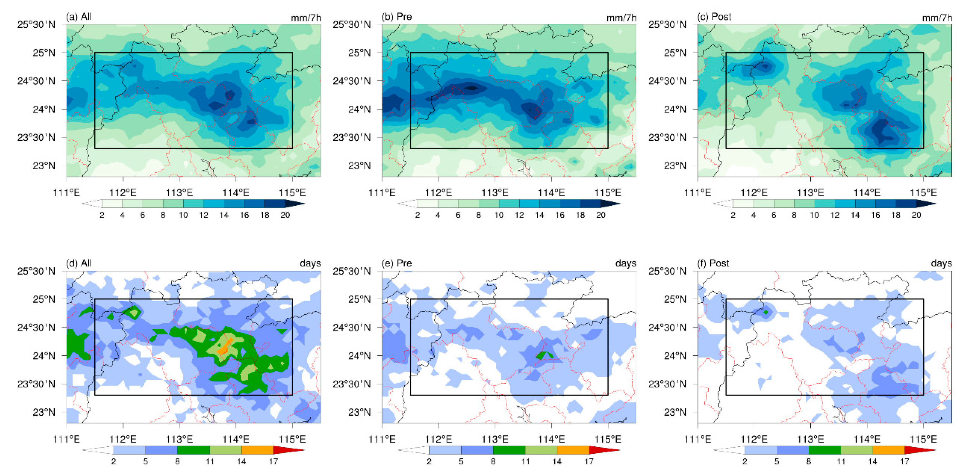
Based on the definition of MEP events, 121 MEP events in the inland region during the pre-summer season have been selected, where the extreme PA accounts for about 56% of the total morning precipitation. Many studies have shown that there are significant changes in the atmospheric circulation and rainfall patterns in GD before and after the SCS monsoon in mid-May. Hence, the pre-summer rainy season can be divided into pre-monsoon onset and post-monsoon onset periods based on the onset date of the SCS summer monsoon in each year, as determined by the monsoon monitoring system of the CMA’s National Climate Center [44]. The spatial distribution of MEP is similar to the pattern of mean precipitation (Figure 2a), and the number of occurrence days is the key factor for the extreme PA. The maximum center is located in the north of Guangzhou, near the border of Qiangyuan and Shaoguan (Figure 3a,d). Additionally, the spatial pattern of MEP differs between pre- and post-monsoon onset periods. Before the onset of the SCS monsoon, the extreme rainfall belt was shaped in an east-west direction, which may be attributed to the eastward propagation of the rainfall system from GX. However, the belt of extreme precipitation is located in the southeastern part of the inland region after the establishment of monsoonal flows (Figure 3b,c).
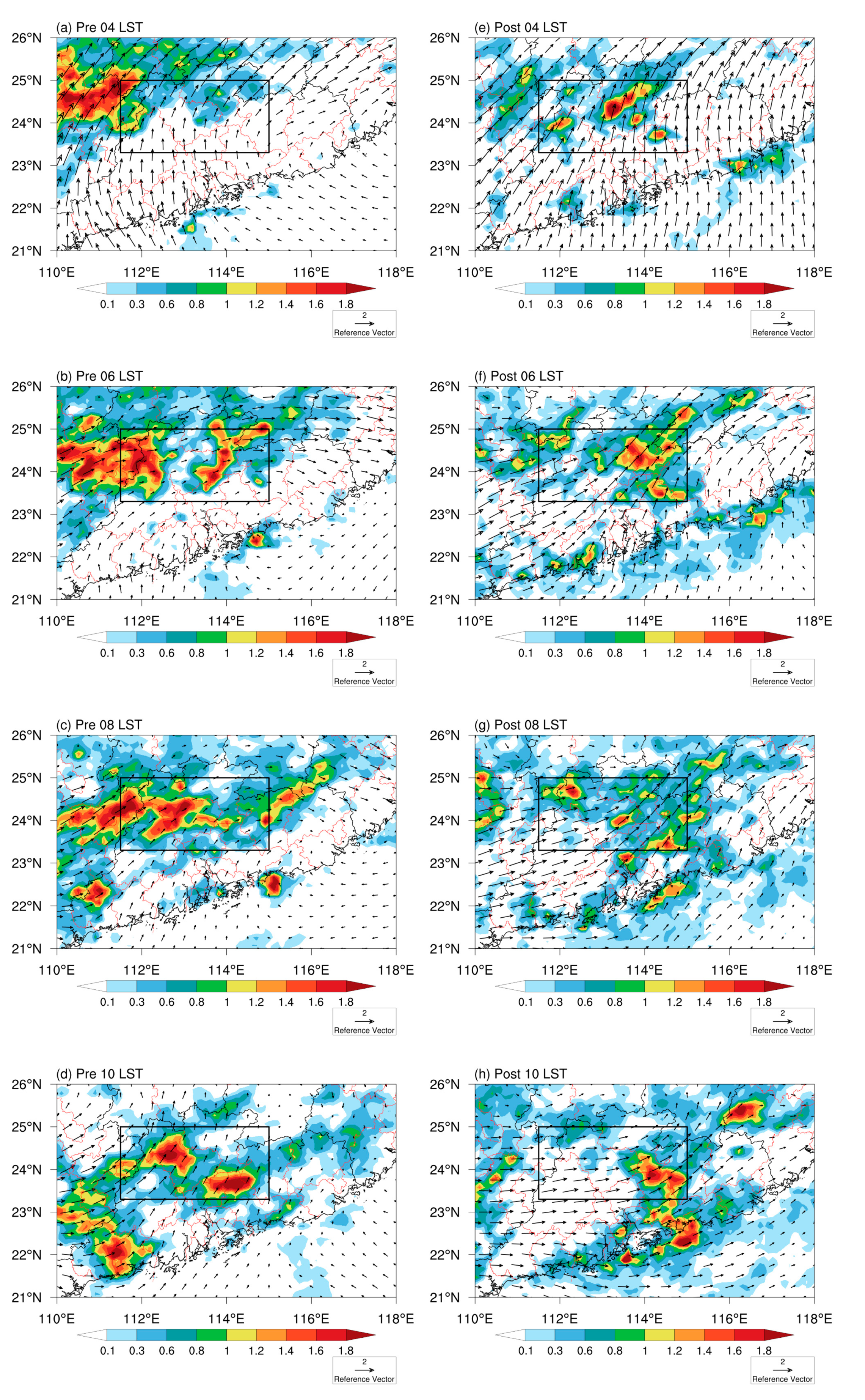
The diurnal variation of MEP and low-level winds during the pre-monsoon onset and post-monsoon onset periods is displayed in Figure 4. In the early morning, around 04 LST, the obvious rainfall belt can be found in the northwest of GD along the Nanling mountain, due to the increased southerly winds that are carrying a significant amount of moist and warm air (Figure 4a). Meanwhile, another weak rainfall belt appears in the northeast of inland GD prior to the arrival of southeastward-propagating rainfall systems. This is due to the interaction of accelerated southwesterly winds and topography. Two hours later (06 LST), the rainfall belt propagates southeastward and moves to the western region of inland GD due to the deviating westerly winds caused by the inertial oscillation [45,46,47]. It is worth noting that the locally grown rainfall system in the east has developed and become stronger (Figure 4b). At 08 LST, the southeastward-propagating rainfall system reaches the central part of the inland region. However, the locally grown rainfall system further moves eastward and weakens (Figure 4c). As time goes on, the southeastward-propagating rainfall system develops into two prominent rainfall centers. One is located in Qinagyuan, and the other is near Guangzhou, due to the increased southwesterly winds at 10 LST (Figure 4d).
During the post-monsoon onset periods, the region experiences dominant, accelerated southerly winds. The locally grown rainfall belt is located in the northern inland of GD. However, the southeastward-propagating rainfall system from the northwest weakens, which is consistent with previous studies [4,9] (Figure 4e). At 06 LST, the locally grown rainfall belt is further strengthened in terms of intensity and range over the eastern inland of GD with the enhanced southwesterly winds (Figure 4f). Two hours later, the rainfall belt begins to weaken, although the range of the rainfall area expands further (Figure 4g). Soon afterwards, the southerly winds decrease, and the rainfall center can only be found in the southeast of the inland at 10 LST (Figure 4h). At the same time, the coastal rainfall system also develops.

3.1.2. The Principal Modes and Evolution Processes of MEP

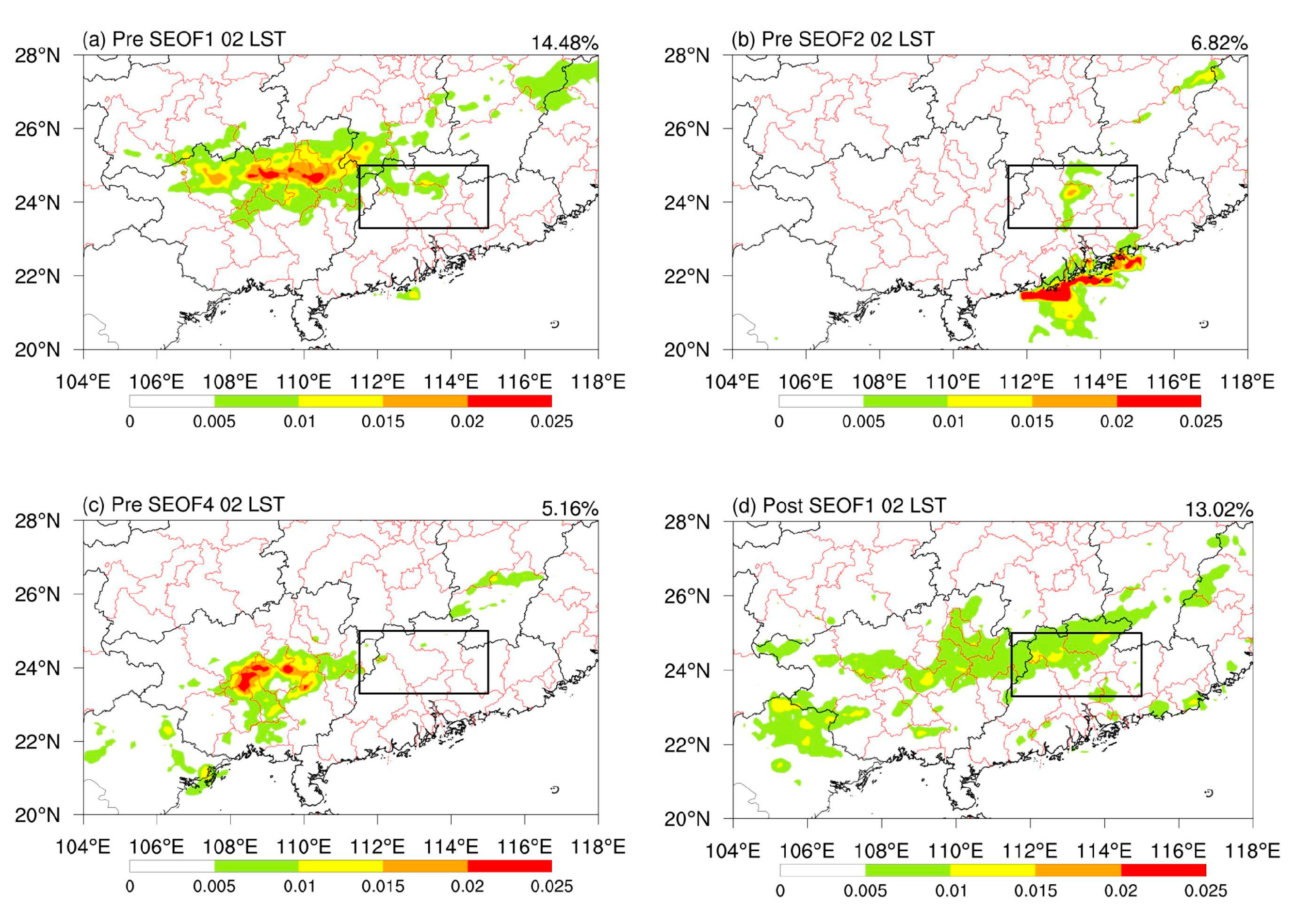
As mentioned above, a statistical method similar to S-EOF is used in this study to explore the principal modes of MEP from 02 LST to 10 LST. The spatial distributions of the first (14%), second (6.82%), and fourth (5.16%) modes during the pre-monsoon onset period, as well as the first (13.02%) mode during the post-monsoon onset period passing the north significant test [48] at 02 LST, are shown in Figure 5. Before the onset of the SCS monsoon, three key source regions of MEP can be identified. The first principal mode shows a similar pattern to the climatic state of MEP, with the preceding rainfall belt located in the northwestern mountains (Figure 4a and Figure 5a). The second principal mode indicates a weak, locally growing rainfall system that originates in the central part of the inland GD (Figure 5b). The third major rainfall system is from the southwest of the inland boundary and in the central plains of GX (Figure 5c). During the post-monsoon onset period, only the first principal mode of MEP has passed the north significant test. The result indicates that an obvious preceding rainfall belt has occurred in the northern inland and south of the Nanling mountains (Figure 5d).
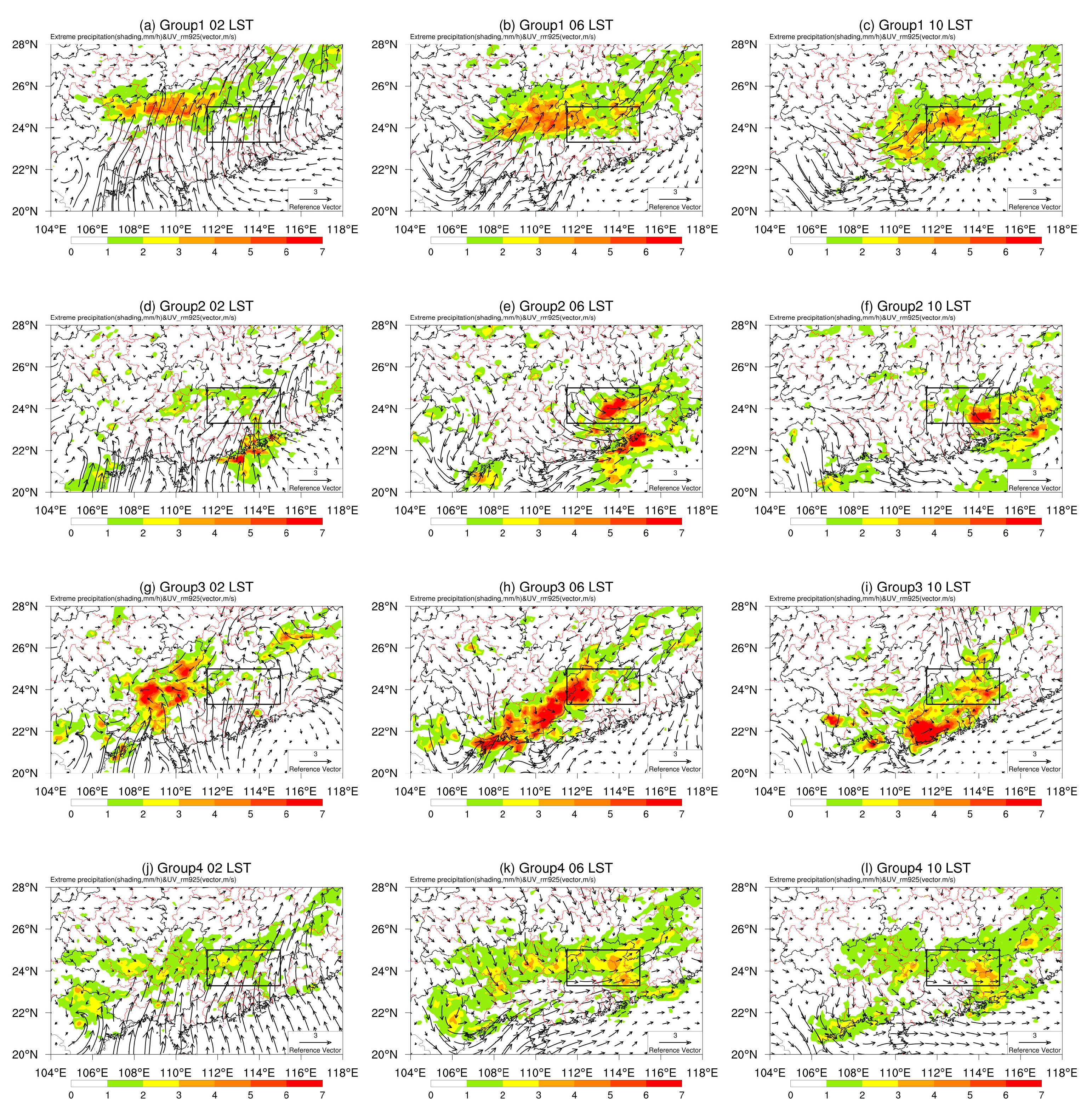
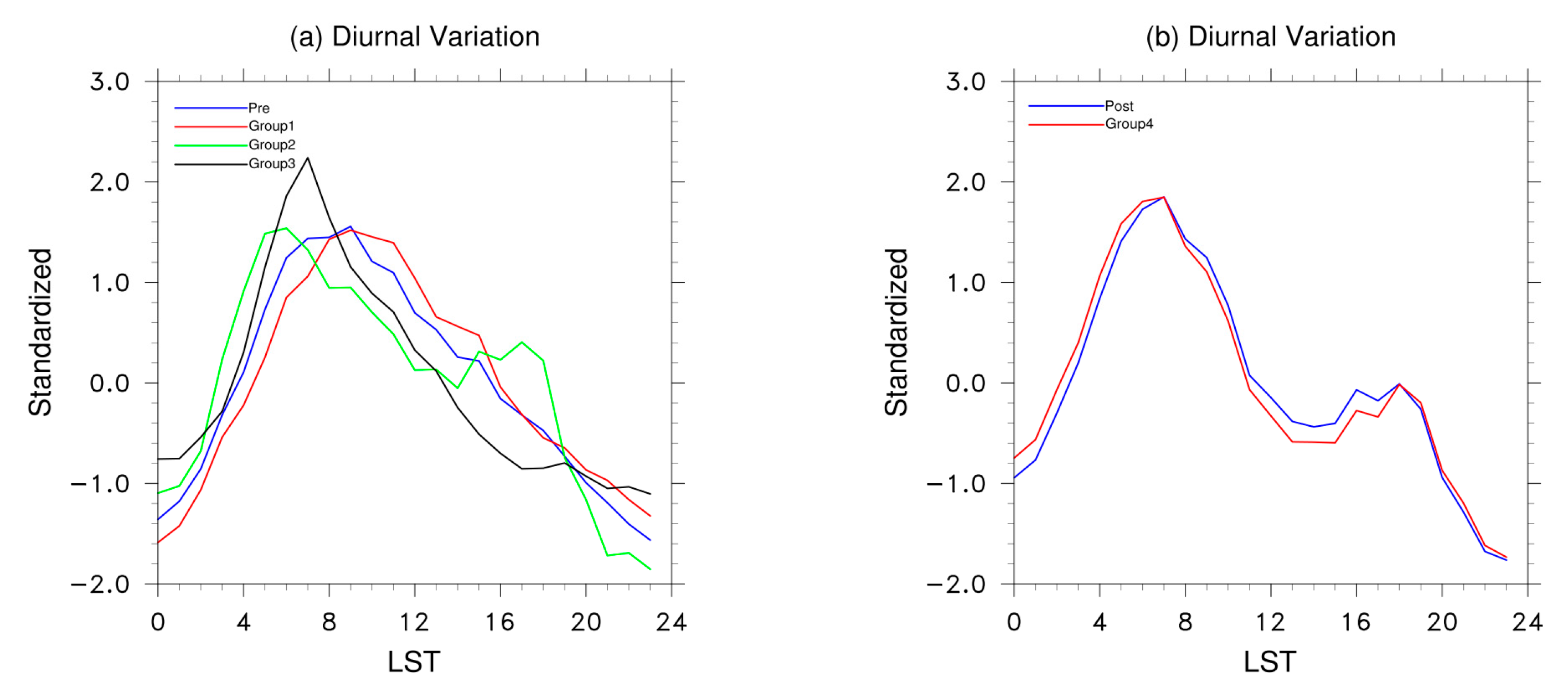
Based on the correlation coefficients of the principal modes and rainfall patterns, which are greater than 0.1, the MEP events can be classified into four groups. These groups consist of three categories that occur before the establishment of SCS monsoons and one category that occurs after the onset of SCS monsoons [49]. The number of MEP events and the correlation coefficients at different times for four categories are shown in Table 1. The evolution processes of four groups of MEP and the diurnal variation of low-level winds are presented in Figure 6. The first group of MEP (G1) is a typical southeastward-propagating rainfall system from the northwestern mountains to the inland region, which can also be observed in the mean state pattern (Figure 4). The anomalous southerly winds are strongest in G1 during late night (02 LST), resulting in a longer duration of rainfall from 06 to 12 LST (Figure 7a) and a wider range of rainfall. The increased westerly winds in the morning are favorable for propagation. The second group of MEP (G2) is a locally growing rainfall system that originates in the south of the Nanling mountains at night. It develops into the mature stage in the morning and then moves southward. It is also worth noting that the precipitation of the coastal rainfall belt is also intense at the same time (Figure 6d–f). In comparison to G1, G2 has a smaller range of rainfall and a shorter lifespan, but it has a stronger intensity. The anomalous southerly winds are weakest in G2 during late nights. However, the primary one can be found in GD, especially in the eastern part of the inland region. In the morning, the increased northerly winds in the target domain confront the southerly winds from SCS, creating a cyclonic circulation that promotes convection initiation and the development of convection. Moreover, there are two rainfall peaks for G2. The first peak occurs at 05–06 LST in the morning, while the second weaker peak occurs in the late afternoon (Figure 7a). The third group of MEP (G3) is the eastward-propagating rainfall system from the central region of GX with the intensive southerly winds at 02 LST. The anomalous cyclonic circulation dominates in GX, consistent with the rainfall center and accompanied by increased southeasterly winds. In the morning, the eastward-propagating rainfall belt presents a narrow southwest to northeast shape and moves to the border between GX and GD. This leads to intense rainfall in the western part of the inland region, accompanied by weak westerly winds. At 10 LST, the rainfall belt propagates to the GD, with large-scale rainfall occurring in the southern inland areas but with weak intensity (Figure 6g–j). The rainfall peak of G3 occurs 2 h earlier (at 07 LST) compared to the average MEP events (at 09 LST) during the pre-monsoon onset period. The fourth group of MEP (G4) represents the primary evolutionary processes during the post-monsoon onset period. The main rainfall belt has been observed in the northern inland during the nighttime, accompanied by anomalous southerly winds similar to G1, albeit slightly weaker at 02 LST. The rainfall range expands to nearly the entire inland area at 06 LST, and it weakens at 10 LST (Figure 6l). Compared to G1, the southerly winds in G4 weaken in the morning due to reduced moisture. Instead, there is an increase in northerly winds carrying cold air in the northwest of GD inland, which promotes frontal precipitation. The diurnal variation of G4 follows the same pattern as the mean state of MEP events, with the morning rainfall peak occurring at 06 LST (Figure 7b). In summary, the MEP systems were more complex before the onset of the SCS monsoon. The majority of MEP events exhibit a single rainfall peak at 09 LST in the morning. On the other hand, the rainfall in G2 shows the earliest peak in the morning at 06 LST and a weak peak in the late afternoon. The G3 experiences an earlier rainfall peak in the morning at 07 LST. The peak of morning rainfall occurs 3 h in advance after the onset of the SCS monsoon, and a weak peak of late afternoon rainfall can also be observed in G4.
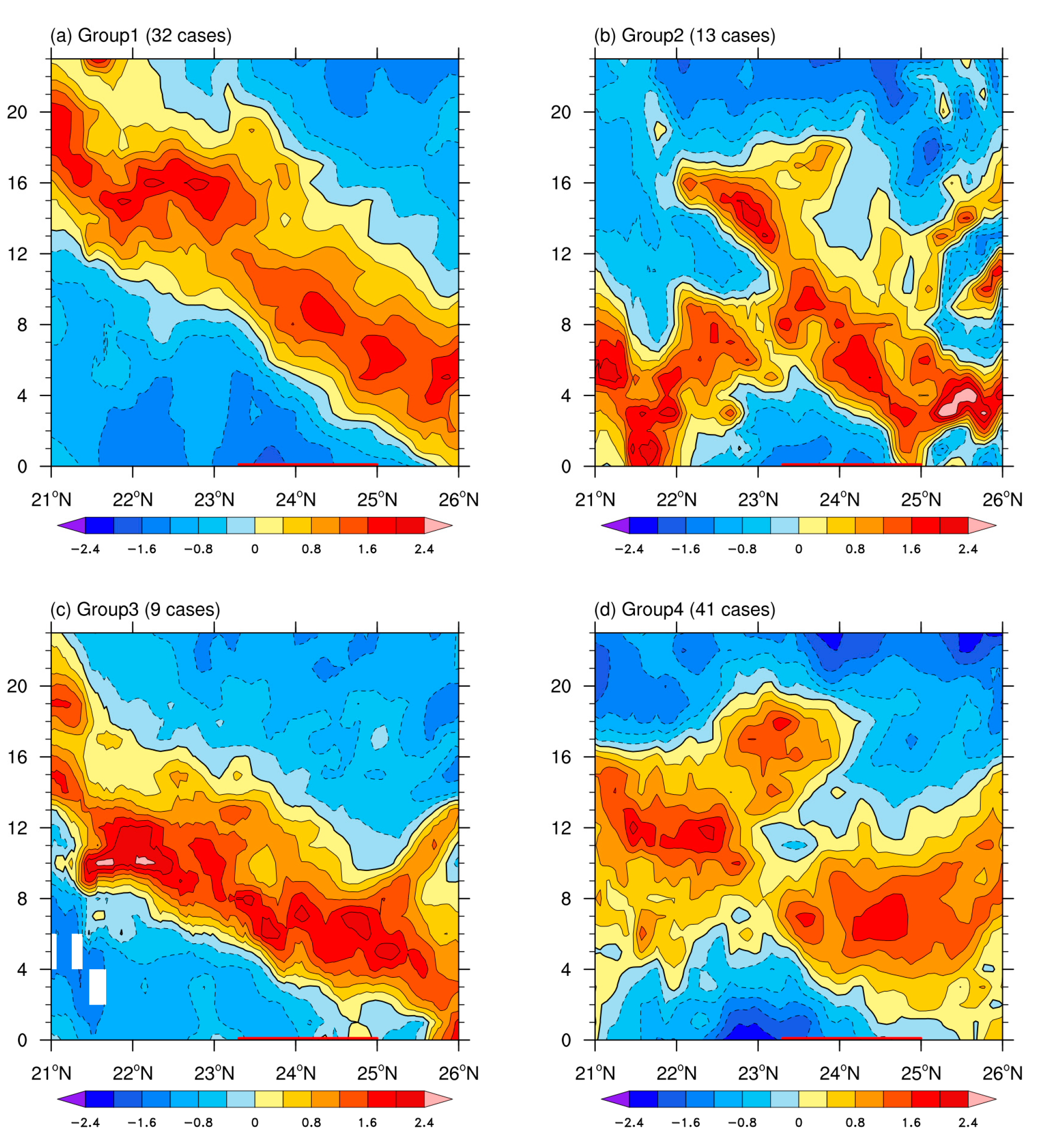
The time–longitude diagrams showing diurnal variations for four groups of MEP events averaged from 23° N to 26° N are presented in Figure 8. Meanwhile, the meridional propagating patterns averaged from 111° E to 116° E are displayed in Figure 9. The apparent southeastward-propagating rainfall system of G1 from the northern part of GX reaches to the inland region after 06 LST and then moves further to the southeast coastal region in the late afternoon (Figure 8a and Figure 9a). Additionally, a weak rainfall belt typically begins in the early morning around 04 LST in the center of the target domain, approximately 113° E, then moves eastward, reaching to the eastern boundary of the inland region by 07 LST. The rainfall systems are more complex for G2 (Figure 8b and Figure 9b). A southeastward-propagating rainfall system with a small range and short lifetime from GX is inducing MEP events in the area west of 113° E. Another locally generated rainfall system in the eastern inland area, with a longer lifetime, moves southeast and meets the coastal rainfall system at the southern boundary of the inland region. The primary rainfall belt of G3 is similar to that of G1, but with greater intensity and a more southerly location due to the source region in central GX. As a result, the southeastward-propagating rainfall system of G3 reaches in the inland region of GD earlier than that of G1. In contrast to the pre-monsoon onset period, a locally quasi-stationary rainfall system is generated in the northwestern boundary of the inland area at late night before the eastward propagating rainfall system from GX, and it strengthens in the early morning (04–08 LST) (Figure 8d). Furthermore, the local rainfall system along 113° E moves eastward with increased intensity. The duration of the MEP decreases with latitude; however, the rainfall peak occurs at 06 LST (Figure 9d). It is noteworthy that the rainfall belts are more likely to form or intensify near 113° E, possibly due to orographic lifting, warm, moist air carried by the enhanced southwesterly winds, and synoptic systems [13,36,50].

3.2. The Possible Physical Mechanisms for the Principal Modes of MEP

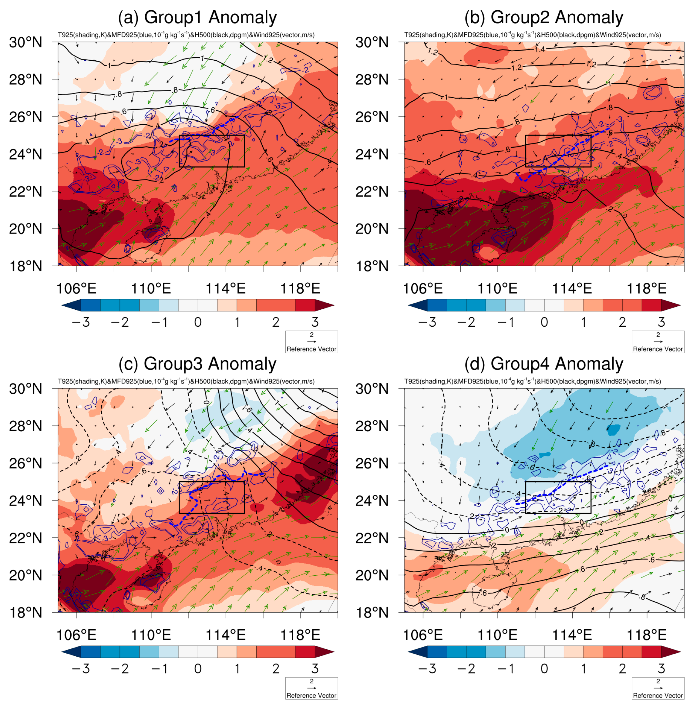
As mentioned above, the four typical MEP modes have different rainfall systems and source regions. However, the associated environmental conditions and physical mechanisms are still unclear. Consequently, the corresponding atmospheric circulations are presented in Figure 10. The significant rise in temperature of over 2 °C is most prominent south of 25° N, accompanied by the strongest southwesterly winds exceeding 3 m/s for G1. The intensified southerly winds extend to the northern boundary of the inland GD, bringing in ample warm and moist air from the SCS. Furthermore, the long and narrow moisture convergence is situated in the northern part from GX to GD, which is consistent with the southeastward-propagating rainfall belt from the northwestern mountains to the inland (Figure 6a and Figure 10a). The strong westerly winds in the troposphere support the eastward movement of the rainfall system. Moreover, a clear shear line can be found to the north of the inland GD. In contrast, the warming range extends further to 30° N due to the small meridional gradients of temperature and geopotential height, resulting in weak synoptic processes for G2 (Figure 10b). The MEP of G2 is similar to warm-sector heavy rainfall [2,8]. The leading edge of the anomalous southwesterly winds is situated in the southeastern inland, coinciding with the center of moisture convergence, which has led to the locally growing rainfall system there (Figure 6e,f). The weak westerly winds at low levels are not conducive to eastward propagation (Figure 8b). Compared to G1, the southwesterly wind and temperature increase at the low level for G3 are situated to the south, leading to intensified moisture convergence consistent with the rainfall pattern observed in central GX (Figure 6g–i). Furthermore, a negative temperature anomaly can be observed in the northeastern region, characterized by greater temperature gradients and an anomalous vortex in the western inland area, leading to a stronger MEP. After the onset of the SCS monsoon, the cold air intrudes further southward, confronting moist warm air from the SCS and inducing heavy frontal precipitation in the target domain. The anomalous southwesterly winds are more intense in the eastern part of the inland region, bringing additional moisture in line with the center of MEP in G4 (Figure 6j–l and Figure 10d). The various synoptic systems of four groups of MEP are consistent with previous studies [15,51].
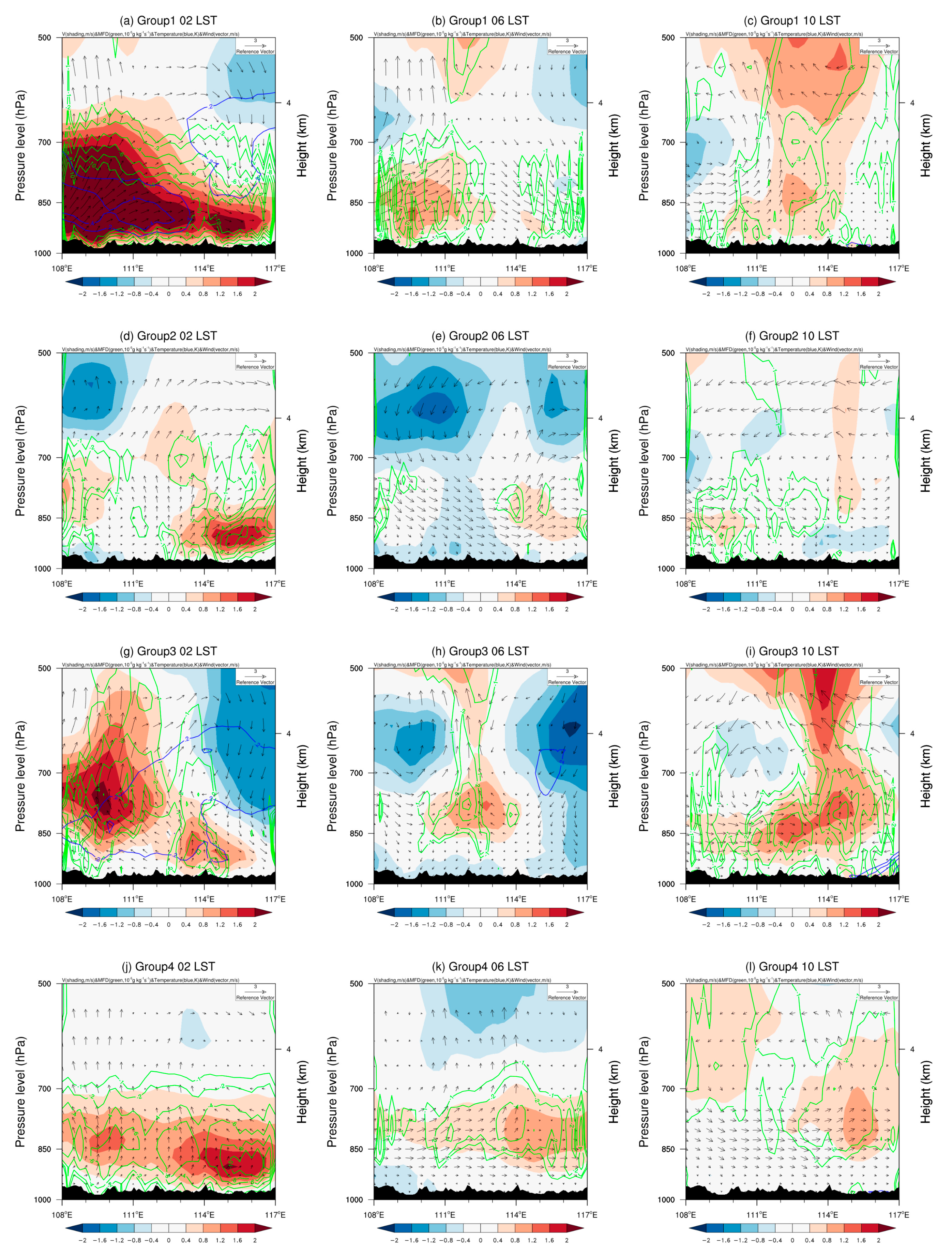
The perturbation of vertical circulation, meridional winds, positive temperature, and moisture flux divergence with respect to their daily means are shown in Figure 11. As mentioned earlier, the southwesterly wind deviations are notable in G1 from the surface to 700 hPa in the region west of 111° E associated with the boundary layer jet (BLJ) and SLLJ [13,19,52], which bring substantial high θ e and moist air with strong upward motion in GX at 02 LST (Figure 11a), consistent with the rainfall patterns shown in Figure 6a. In the morning at 06 LST, the southerly winds became weak, but the anomalous moisture flux convergence can still be observed in GX. The stronger westerly winds favor the eastward movement of the rainfall system. Hence, the upward branch moves eastward to the inland GD with the intensified southerly winds between 111° E and 115° E (target domain) at 10 LST, leading to MEP events. In contrast, the weak accelerated low-level southwesterly winds can only be observed in the eastern part of inland GD in G2, with the ascendant flow at 02 LST (Figure 11d). In the morning at 06 LST, the intensity and range of southerly winds further weaken. However, the anomalous vertical circulation is evident with the stronger westerly winds and the upward flows to the east of 114° E, which are consistent with the rainfall center. At 10 LST, there is no apparent southwest anomaly to supply sufficient energy, thus the rainfall belt in G2 is short-lived. The southeasterly winds dominate in the western inland region late at night in G3. The maximum center of anomalous southerly winds is located between 850 hPa and 700 hPa, associated with a synoptic system exhibiting stronger upward motions up to 500 hPa in GX (Figure 11g). Meanwhile, the stronger meridional winds at 700 hPa are associated with the large-scale wave-train pattern. Weak, accelerated southerly winds can also be found in the low levels of the eastern inland area of GD. At 06 LST in the morning, the easterly winds in the western boundary of the inland region shift to westerly winds, creating a convergence area with the anomalous easterly winds and the upward flows in the western part of inland region (111.5–113.5° E). This convergence area is where the maximum rainfall center is located (Figure 6h). At 10 LST, the upward branch propagates eastward into the inland area, accompanied by intensified southwesterly winds. After the onset of the SCS monsoon, the vertical circulation of G4 is somewhat similar to G2, but with stronger southerly winds that are also present in GX late at night, coinciding well with the rainfall belt in the northwest of inland GD (Figure 11j). The intensified updraft flows in the eastern inland in the morning provide favorable dynamic conditions for local convection initiation.
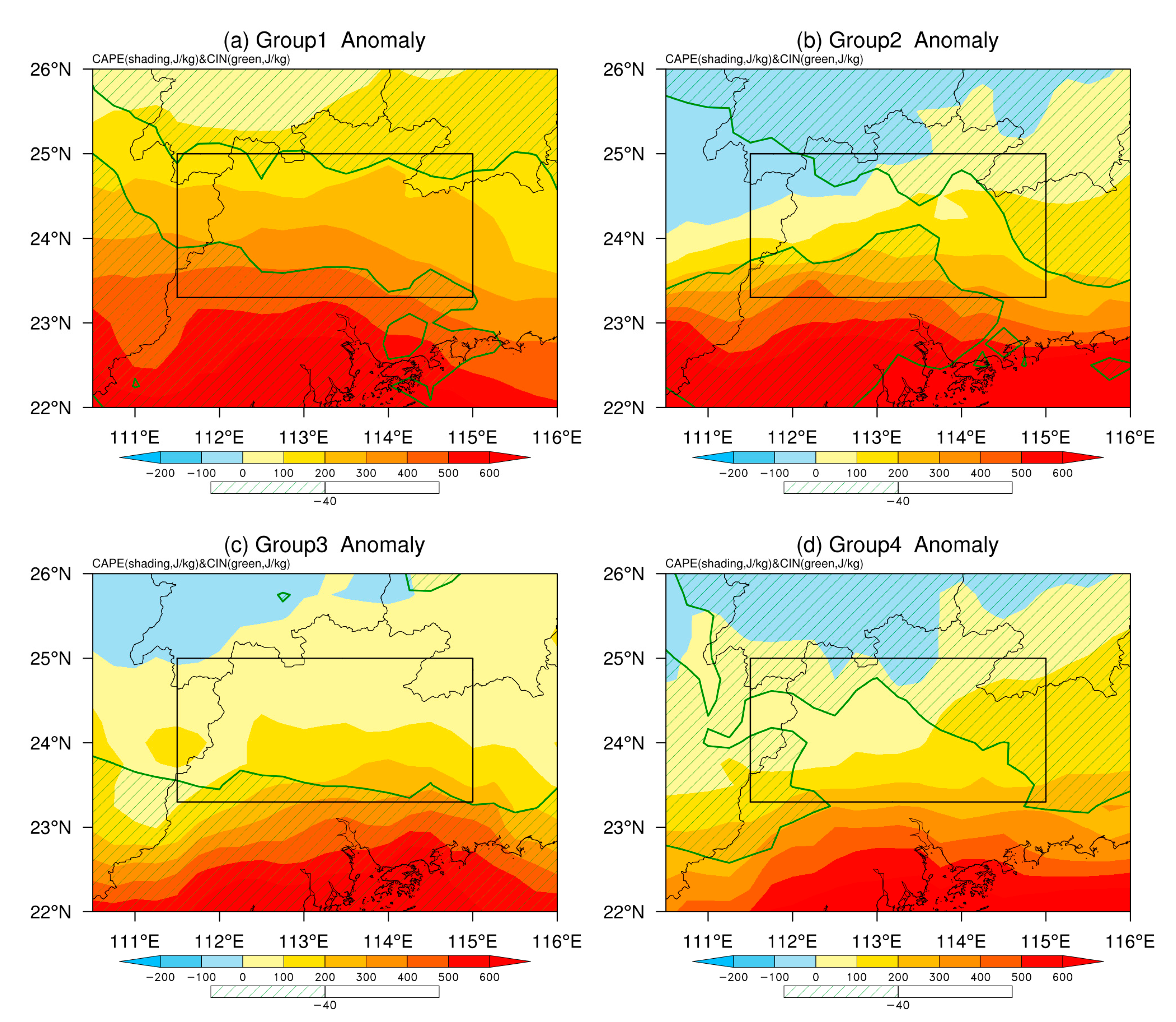
The MEP events demonstrate a strong association with organized nocturnal convection [12,53,54]. Consequently, the CAPE and convective inhibition (CIN) of different MEP groups have been estimated in Figure 12. The strongest increase in CAPE of G1 dominates in the entire region, favoring the initiation and development of convection. Meanwhile, the lower CIN can also be found at the north and south boundaries of the target area (Figure 12a). The enhanced CAPE of G2 is located in the southeastern part of the inland region, in accordance with the location of the rainfall center. Compared to other MEP groups, the CIN in G2 has the lowest value, which contributes to the unstable atmospheric circulation that supports the locally generated rainfall system. The higher CAPE in G3 is located to the south, with the smaller CIN inducing the MEP in the southern part of the inland area. The CAPE in G4 is not as strong as in G1 due to weak rainfall intensity. However, lower CIN can be found in the northern and eastern parts of the inland, promoting the generation of local convection.
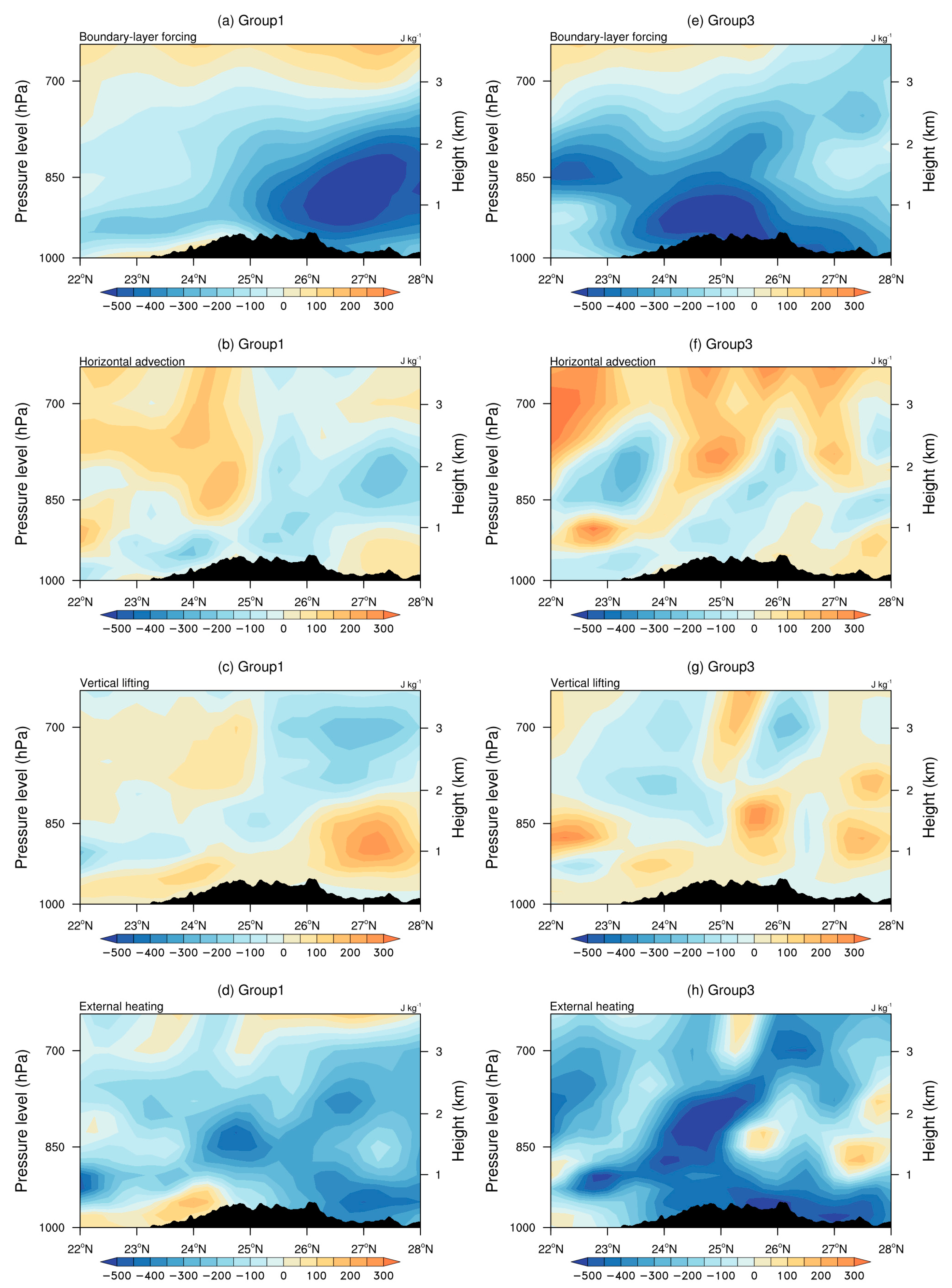
The previous studies revealed the rate of CAPE generation associated with boundary-layer forcing, including horizontal advection, vertical lifting, and external heating [36,37]. Figure 13a shows that the low-level CAPE of G1 decreases of about 400–500 J kg−1 north of 25° N, attributed to the boundary layer forcing. The increase in CAPE by about 100–200 J kg−1 due to horizontal advection from SCS is evident above 850 hPa, indicating that the inflow of warm, moist air from the south is enhancing the instability (Figure 13b). Meanwhile, horizontal advection reduces CAPE by about 200 J kg−1 in the low levels by transporting the warm, moist air to the northern area. Additionally, vertical lifting plays a significant role in generating CAPE, and the maximum center is located to the north of the inland boundary (Figure 13c). Figure 13d shows the negative CAPE north of 24.5° N due to the strong cooling associated with the MEP, while the increased CAPE due to the warm air from SCS is prominent in the boundary layer. Compared to G1, the maximum center of negative CAPE due to boundary-layer forcing in G3 is situated between 23° N and 26° N. The horizontal advection and vertical lifting are also two important factors for changes in CAPE, but the affected area is located to the south (Figure 13f,g). The cooling pattern is also in agreement with the rainfall belt in G3 (Figure 13h).
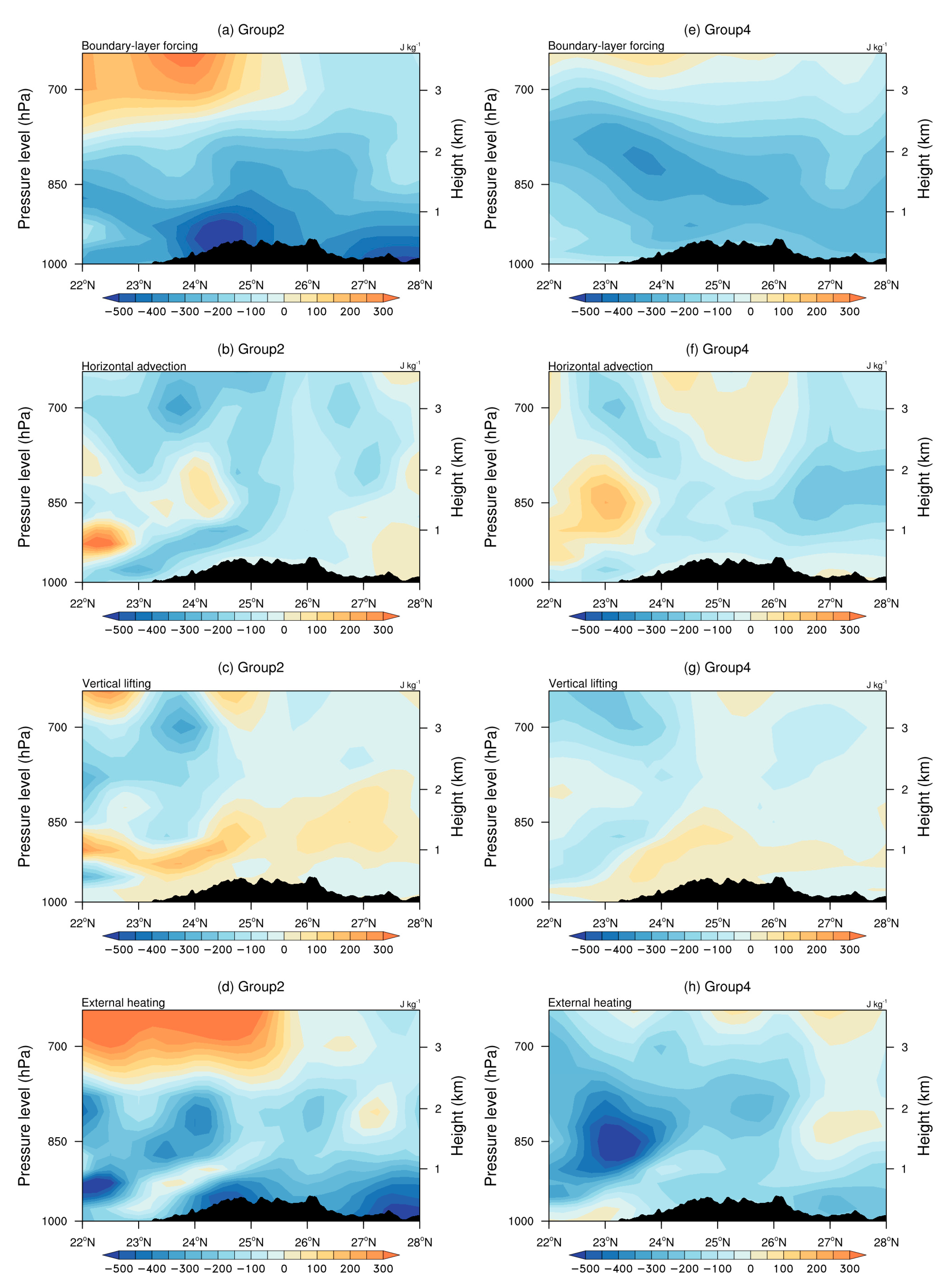
The change rate of CAPE in G2 and G4 is not as pronounced as it is in G1 and G3. However, negative CAPE due to boundary forcing can also be found at low levels in the inland area. Instead of horizontal advection, vertical lifting is the primary factor contributing to the increase in CAPE (Figure 14a–d). The CAPE change of G4 is lowest, and the inflow of warm, moist air can only be found in the coastal area, not invading the inland region. The vertical lifting creates an unstable environment for the locally growing rainfall system (Figure 14e–h).

4. Discussion and Conclusions

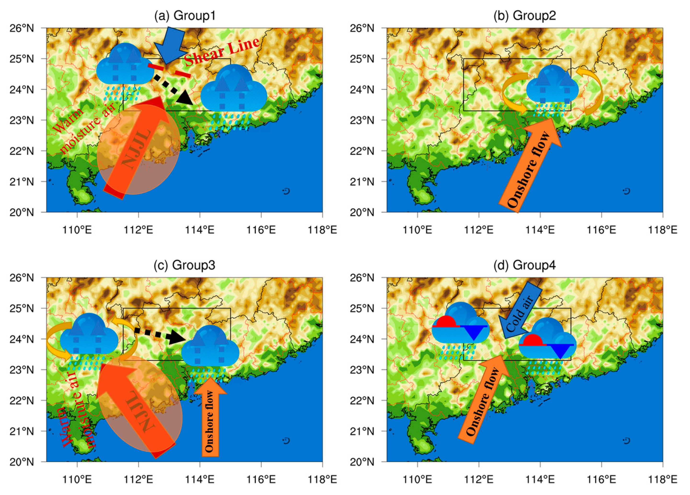
In this study, the spatial and temporal characteristics of MEP events over inland GD have been investigated during the pre-summer period from 2008 to 2017. More importantly, three (one) principal modes of MEP during the pre-monsoon onset (post-monsoon onset) period and their evolution processes are displayed to reveal the main rainfall systems of MEP. The potential physical mechanisms have been explored, and the corresponding schematic diagram is provided in Figure 15. The main conclusions are as follows:
  • The spatial distribution of MEP differs between pre- and post-monsoon onset periods. Before the onset of the SCS monsoon, the MEP belt is oriented in an east-west direction associated with the eastward-propagating rainfall system from GX. After the establishment of SCS monsoonal flows, the MEP center is located in the southeast of the inland region.
  • Based on the three principal modes during the pre-monsoon onset period and one principal mode during the post-monsoon onset period, the MEP events over the inland GD can be classified into four groups. G1 is a typical southeastward-propagating rainfall system from the northwestern mountains to the inland region. However, G2 is a locally generated rainfall system that develops in the south of the Nanling mountain at night, reaches maturity in the morning, and then moves southward. In relation to G3, the eastward-propagating rainfall system from central GX extends to the southern inland region. Compared to G1, the southeastward-propagating rainfall system from the northwest weakens, and the frontal precipitation in the northern inland area becomes the primary rainfall center of G4.
  • During the night, the strongest accelerated southwesterly winds accelerate from the surface to the middle level of the troposphere, bringing abundant warm and wet air from SCS in G1 combined with the shear line and highest CAPE, leading to heavy rainfall in the northwest of the inland region. The strengthened westerly winds are conducive to the eastward movement of the rainfall system, with the upward branch resulting in the peak of morning rainfall at 09 LST in the inland GD. Accompanied by large-scale warming, the MEP of G2 is warm-sector heavy rainfall without the obvious synoptic processes. The weak anomalous southwesterly winds can only be observed in the southeastern inland, where the moisture convergence and ascending flows contribute to the unstable atmospheric circulation, resulting in a locally generated rainfall belt at 06 LST. This is in accord with the higher CAPE and lower CIN. The intensified southeasterly winds prevail in GX above 850 hPa at night, accompanied by the anomalous cyclonic circulation in the western inland, leading to the stronger MEP of G3. In the morning, the easterly winds shift to westerly winds, facilitating the eastward movement of the rainfall center towards the inland region, with the peak rainfall occurring at 07 LST. After the onset of the SCS monsoon, cold air intrudes further southward, confronting moist warm air from the SCS and inducing heavy frontal precipitation of G4 in the inland region. The intensified southerly winds are primarily found at low levels, especially in the eastern inland, with a lower CIN. Furthermore, horizontal advection and vertical lifting are also two important factors for CAPE change in G1 and G3. However, vertical lifting is the primary factor contributing to the change in CAPE in G2 and G4.
This study provides a new objective classification of the MEP over the inland GD. The related analysis has the potential to enhance the forecasting of extreme rainfall and flood disasters in inland cities. The various atmospheric circulation patterns and the origins of rainfall belts during the late night can be used to forecast the extreme precipitation in the morning. However, the fine structure of the MEP in different groups and the specific physical processes of convection initiation and development require high-resolution numerical simulations. The sensitivity experiment of the topography and winds is also worth studying.

Author Contributions

Conceptualization, X.L. and X.W.; methodology, X.L. and Y.L.; software, X.W.; validation, X.W. and X.L.; formal analysis, X.W.; investigation, X.W.; resources, K.X.; data curation, J.W.; writing—original draft preparation, X.L.; writing—review and editing, X.W.; visualization, X.W.; supervision, X.L.; project administration, X.L.; funding acquisition, X.L. All authors have read and agreed to the published version of the manuscript.

Funding

This research was funded by the National Natural Science Foundation of China (Grant No. 41905085) and Guangzhou Science and Technology Plan Projects (Grant No. 202002030196).

Institutional Review Board Statement

Not applicable.

Informed Consent Statement

Not applicable.

Data Availability Statement

The data presented in this study are available on request from the corresponding author. The data are not publicly available due to privacy.

Acknowledgments

We acknowledge the CMA for providing rain gauge and satellite precipitation data available.

Conflicts of Interest

The authors declare no conflict of interest.

References

  1. Ding, Y. Monsoons over China; Springer: Dordrecht, The Netherlands, 1994; 420p. [Google Scholar]
  2. Luo, Y.; Zhang, R.; Wan, Q.; Wang, B.; Wang, W.K.; Hu, Z.; Jou, B.J.-D.; Lin, Y.; Johnson, R.H.; Chang, C.-P.; et al. The Southern China Monsoon Rainfall Experiment (SCMREX). Bull. Am. Meteorol. Soc. 2017, 98, 999–1013. [Google Scholar] [CrossRef]
  3. Huang, L.; Luo, Y.; Zhang, D. The relationship between anomalous Presummer extreme rainfall over south China and synoptic disturbances. J. Geophys. Res. Atmos. 2018, 123, 3395–3413. [Google Scholar] [CrossRef]
  4. Li, Y.P.; Lu, X.; Xiang, K.; Jiang, M. The characteristics and evolution process of presummer intense regional rainfall over the Pearl River Delta metropolitan region. Int. J. Clim. 2023, 43, 3159–3172. [Google Scholar] [CrossRef]
  5. Chang, M.; Fan, S.; Fan, Q.; Chen, W.; Zhang, Y.; Wang, Y.; Wang, X. Impact of refined land surface properties on the simulation of a heavy convective rainfall process in the Pearl River Delta region, China. Asia-Pac. J. Atmos. Sci. 2014, 50, 93–103. [Google Scholar] [CrossRef]
  6. Du, Y.; Chen, G. Heavy rainfall associated with double low-level jets over southern China. Part I: Ensemble-based analysis. Mon. Weather. Rev. 2018, 146, 3827–3844. [Google Scholar] [CrossRef]
  7. Chen, G. Diurnal cycle of the Asian summer monsoon: Air pump of the second kind. J. Clim. 2020, 33, 1747–1755. [Google Scholar] [CrossRef]
  8. Luo, Y.L.; Wang, H.; Zhang, R.H.; Qian, W.; Luo, Z. Comparison of rainfall characteristics and convective properties of monsoon precipitation systems over South China and the Yangze and Huai River basin. J. Clim. 2013, 26, 110–132. [Google Scholar] [CrossRef]
  9. Jiang, Z.; Zhang, D.-L.; Xia, R.; Qian, T. Diurnal variations of presummer rainfall over southern China. J. Clim. 2017, 30, 755–773. [Google Scholar] [CrossRef]
  10. Chen, G.; Lan, R.; Zeng, W.; Pan, H.; Li, W. Diurnal variations of rainfall in surface and satellite observations at the monsoon coast (south China). J. Clim. 2018, 31, 1703–1724. [Google Scholar] [CrossRef]
  11. Yu, R.; Xu, Y.; Zhou, T.; Li, J. Relation between rainfall duration and diurnal variation in the warm season precipitation over central eastern China. Geophys. Res. Lett. 2007, 34, L13703. [Google Scholar] [CrossRef]
  12. Chen, G.; Yoshida, R.; Sha, W.; Iwasaki, T.; Qin, H. Convective instability associated with the eastward-propagating rainfall episodes over Eastern China during the warm season. J. Clim. 2014, 27, 2331–2339. [Google Scholar] [CrossRef]
  13. Li, Z.; Luo, Y.; Du, Y.; Chan, J.C.L. Statistical characteristics of pre-summer rainfall over south China and associated synoptic conditions. J. Meteorol. Soc. Jpn. Ser. II 2020, 98, 213–233. [Google Scholar] [CrossRef]
  14. Li, J.; Yu, R.C.; Zhou, T.J. Seasonal variation of the diurnal cycle of rainfall in southern contiguous China. J. Clim. 2008, 21, 6036–6043. [Google Scholar] [CrossRef]
  15. Luo, Y.; Xia, R.; Chan, J.C.L. Characteristics, physical mechanisms, and prediction of pre-summer rainfall over South China: Research progress during 2008–2019. J. Meteorol. Soc. Jpn. Ser. II 2020, 98, 19–42. [Google Scholar] [CrossRef]
  16. Du, Y.; Shen, Y.; Chen, G. Influence of coastal marine boundary layer jets on rainfall in South China. Adv. Atmos. Sci. 2022, 39, 782–801. [Google Scholar] [CrossRef]
  17. Gao, X.W.; Luo, Y.L.; Lin, Y.L.; Bao, X.H. A source of WRF simulation error for the early-summer warm-sector heavy rainfall over South China coast: Land-sea thermal contrast in the boundary layer. J. Geophys. Res. Atmos. 2022, 127, e2021JD035179. [Google Scholar] [CrossRef]
  18. Chen, X.; Zhang, F.; Zhao, K. Diurnal variations of the land–sea breeze and its related precipitation over South China. J. Atmos. Sci. 2016, 73, 4793–4815. [Google Scholar] [CrossRef]
  19. Wu, Y.; Gao, Y.; Chen, D.; Meng, W.; Lin, L.; Lin, L. Synoptic characteristics related to warm-sector torrential rainfall events in South China during the annually first rainy season. J. Trop. Meteorol. 2020, 6, 253–260. [Google Scholar] [CrossRef]
  20. Su, L.; Fung, J.; Li, J.; Wong, W. Trends in diurnal cycle of summertime rainfall over coastal South China in the past 135 years: Characteristics and possible causes. J. Geophys. Res. Atmos. 2021, 126, e2020JD033621. [Google Scholar] [CrossRef]
  21. Dong, F.; Zhi, X.; Zhu, S.; Zhang, L.; Ge, F.; Fan, Y.; Lyu, Y.; Wang, J.; Fraedrich, K. Principal Modes of Diurnal Cycle of Rainfall over South China during the Pre-Summer Rainy Season. J. Clim. 2023, 36, 2457–2470. [Google Scholar] [CrossRef]
  22. Fu, P.; Hu, D.; Zhang, Y.; Li, H.; Gao, M.; Zhao, X. Microphysical characteristics, initiation and maintenance of record heavy rainfall over Guangzhou region on 7 May 2017. Meteor. Monogr. 2018, 44, 500–510. [Google Scholar]
  23. Zhang, S.; Liang, Z.; Wang, D.; Chen, G. Nocturnal convection initiation over inland South China during a record-breaking heavy rainfall event. Mon. Weather. Rev. 2022, 150, 2935–2956. [Google Scholar] [CrossRef]
  24. Deng, W.; Ren, P.; Zhang, D.; Sun, Y.; Wu, N. An extreme monsoon heavy rainfall event over inland South China in June 2022: A synoptic causes analysis. J. Trop. Meteorol. 2023, 29, 16–25. [Google Scholar]
  25. Lu, X.; Wang, Y.; Qiu, Y. A convection-permitting numerical study of diurnal cycles of pre-summer rainfall over southern China. Q. J. R. Meteorol. Soc. 2022, 148, 3677–3693. [Google Scholar] [CrossRef]
  26. Sun, J.; Zhang, Y.; Liu, R.; Fu, S.; Tian, F. A review of research on warm-sector heavy rainfall in China. Adv. Atmos. Sci. 2019, 36, 1299–1307. [Google Scholar] [CrossRef]
  27. Chen, Y.; Luo, Y. Analysis of paths and sources of moisture for the South China rainfall during the presummer rainy season of 1979–2014. J. Meteorol. Res. 2018, 32, 744–757. [Google Scholar] [CrossRef]
  28. Joyce, R.J.; Janowiak, J.E.; Arkin, P.A.; Xie, P. CMORPH: A method that produces global precipitation estimates from passive microwave and infrared data at high spatial and temporal resolution. J. Hydrometeorol. 2004, 5, 487–503. [Google Scholar] [CrossRef]
  29. Xie, P.; Xiong, A.-Y. A conceptual model for constructing high-resolution gauge-satellite merged precipitation analyses. J. Geophys. Res. Atmos. 2011, 116, D21106. [Google Scholar] [CrossRef]
  30. Shou, Y.-X.; Gao, W.; Lu, F. A statistical study of pre-summer hourly extreme rainfall over the Pearl River Delta metropolitan region during 2008–2017. Int. J. Climatol. 2020, 40, 4242–4258. [Google Scholar] [CrossRef]
  31. Zhao, Y.; Huang, A.N.; Kan, M.Y.; Dong, X.N.; Yu, X.J.; Wu, Y.; Zhang, X.D.; Cai, S.X. Characteristics of hourly extreme precipitation along the Yangtze River Basin, China during warm season. Sci. Rep. 2020, 10, 5613. [Google Scholar] [CrossRef]
  32. Hersbach, H.; Bell, B.; Berrisford, P.; Hirahara, S.; Horányi, A.; Muñoz-Sabater, J.; Nicolas, J.; Peubey, C.; Radu, R.; Schepers, D.; et al. The ERA5 global reanalysis. Q. J. R. Meteorol. Soc. 2020, 146, 1999–2049. [Google Scholar] [CrossRef]
  33. Chen, J.; Zheng, Y.; Zhang, X.; Zhu, P. Distribution and diurnal variation of warm-season short-duration heavy rainfall in relation to the MCSs in China. Acta Mech. Sin. 2013, 27, 868–888. [Google Scholar] [CrossRef]
  34. Zheng, Y.; Xue, M.; Li, B.; Chen, J.; Tao, Z. Spatial characteristics of extreme rainfall over China with hourly through 24-hour accumulation periods based on national level hourly rain gauge data. Adv. Atmos. Sci. 2016, 33, 1218–1232. [Google Scholar] [CrossRef]
  35. Wang, B.; An, S. A method for detecting season-dependent modes of climate variability: S-EOF analysis. Geophys. Res. Lett. 2005, 32, L15710. [Google Scholar] [CrossRef]
  36. Ying, M.; Zhang, W.; Yu, H.; Lu, X.; Feng, J.; Fan, Y.; Zhu, Y.; Chen, D. An overview of the China Meteorological Administration tropical cyclone database. J. Atmos. Ocean. Technol. 2014, 31, 287–301. [Google Scholar] [CrossRef]
  37. Emanuel, K. Atmospheric Convection; Oxford University Press: Oxford, UK, 1994; 580p. [Google Scholar]
  38. Zhang, G.J. Convective quasi-equilibrium in midlatitude continental environment and its effect on convective parameterization. J. Geophys. Res. Atmos. 2002, 107, 4220. [Google Scholar] [CrossRef]
  39. Zhang, G.J. Roles of tropospheric and boundary layer forcing in the diurnal cycle of convection in the U.S. southern Great Plains. Geophys. Res. Lett. 2023, 30, 2281. [Google Scholar] [CrossRef]
  40. Liu, X.; Chen, G.; Zhang, S.; Du, Y. Formation of low-level jets over southern China in the meiyu season. Adv. Atmos. Sci. 2023, 40, 1731–1748. [Google Scholar] [CrossRef]
  41. Rao, X.N.; Zhao, K.; Chen, X.C.; Hang, A.N.; Xue, M.; Zhang, Q.H.; Wang, M.J. Influence of synoptic pattern and low-level wind speed on intensity and diurnal variations of orographic convection in summer over Pearl River Delta, South China. J. Geophys. Res. Atmos. 2019, 124, 6157–6179. [Google Scholar] [CrossRef]
  42. Xiao, X.; Sun, J.; Chen, M.; Qie, X.; Wang, Y.; Ying, Z. The characteristics of weakly forced mountain-to-plain precipitation systems based on radar observations and high-resolution reanalysis. J. Geophys. Res. Atmos. 2017, 122, 3193–3213. [Google Scholar] [CrossRef]
  43. Wu, Y.; Sun, J.; Ying, Z.; Xue, L.; Chen, D.; Lin, W. Effects of local-scale orography and urban heat island on the initiation of a record breaking rainfall event. J. Geophys. Res. Atmos. 2021, 126, e2021JD034839. [Google Scholar] [CrossRef]
  44. Ding, Y.; Chan, J.C.L. The East Asian summer monsoon: An overview. Meteorol. Atmos. Phys. 2005, 89, 117–142. [Google Scholar] [CrossRef]
  45. Blackadar, A.K. Boundary layer wind maxima and their significance for the growth of nocturnal inversions. Bull. Am. Meteorol. Soc. 1957, 38, 283–290. [Google Scholar] [CrossRef]
  46. Du, Y.; Zhang, Q.; Chen, Y.-L.; Zhao, Y.; Wang, X. Numerical simulations of spatial distributions and diurnal variations of low-level jets in China during early summer. J. Clim. 2014, 27, 5747–5767. [Google Scholar] [CrossRef]
  47. Cai, Y.; Lu, X.; Chen, G.; Yang, S. Diurnal cycles of Mei-yu rainfall simulated over eastern China: Sensitivity to cumulus convective parameterization. Atmos. Res. 2018, 213, 236–251. [Google Scholar] [CrossRef]
  48. North, G.R.; Bell, T.L.; Cahalan, R.F.; Moeng, F.J. Sampling errors in the estimation of empirical orthogonal functions. Mon. Weather. Rev. 1982, 110, 699–706. [Google Scholar] [CrossRef]
  49. Yuan, W.; Xu, H.; Yu, R.; Li, J.; Zhang, Y.; He, N. Regimes of ainfall preceding regional rainfall events over the plain of Beijing City. Int. J. Climatol. 2018, 38, 4979–4989. [Google Scholar] [CrossRef]
  50. Wang, H.; Luo, Y.; Jou, B.J.-D. Initiation, maintenance and properties of convection in an extreme rainfall event during SCMREX: Observational analysis. J. Geophys. Res. Atmos. 2014, 119, 13206–13232. [Google Scholar] [CrossRef]
  51. Luo, Y.; Wu, M.; Ren, F.; Li, J.; Wong, W.-K. Synoptic Situations of Extreme Hourly Precipitation over China. J. Clim. 2016, 29, 8703–8719. [Google Scholar] [CrossRef]
  52. Du, Y.; Chen, G. Climatology of low-level jets and their impact on rainfall over southern China during the early-summer rainy season. J. Clim. 2019, 32, 8813–8833. [Google Scholar] [CrossRef]
  53. Tuttle, J.D.; Davis, C.A. Corridors of warm season precipitation in the central United States. Mon. Weather. Rev. 2006, 134, 2297–2317. [Google Scholar] [CrossRef]
  54. Trier, S.B.; Davis, C.A.; Ahijevych, D.A.; Weisman, M.L.; Bryan, G.H. Mechanisms supporting long-lived episodes of propagating nocturnal convection within a 7-day WRF model simulation. J. Atmos. Sci. 2006, 63, 2437–2461. [Google Scholar] [CrossRef]
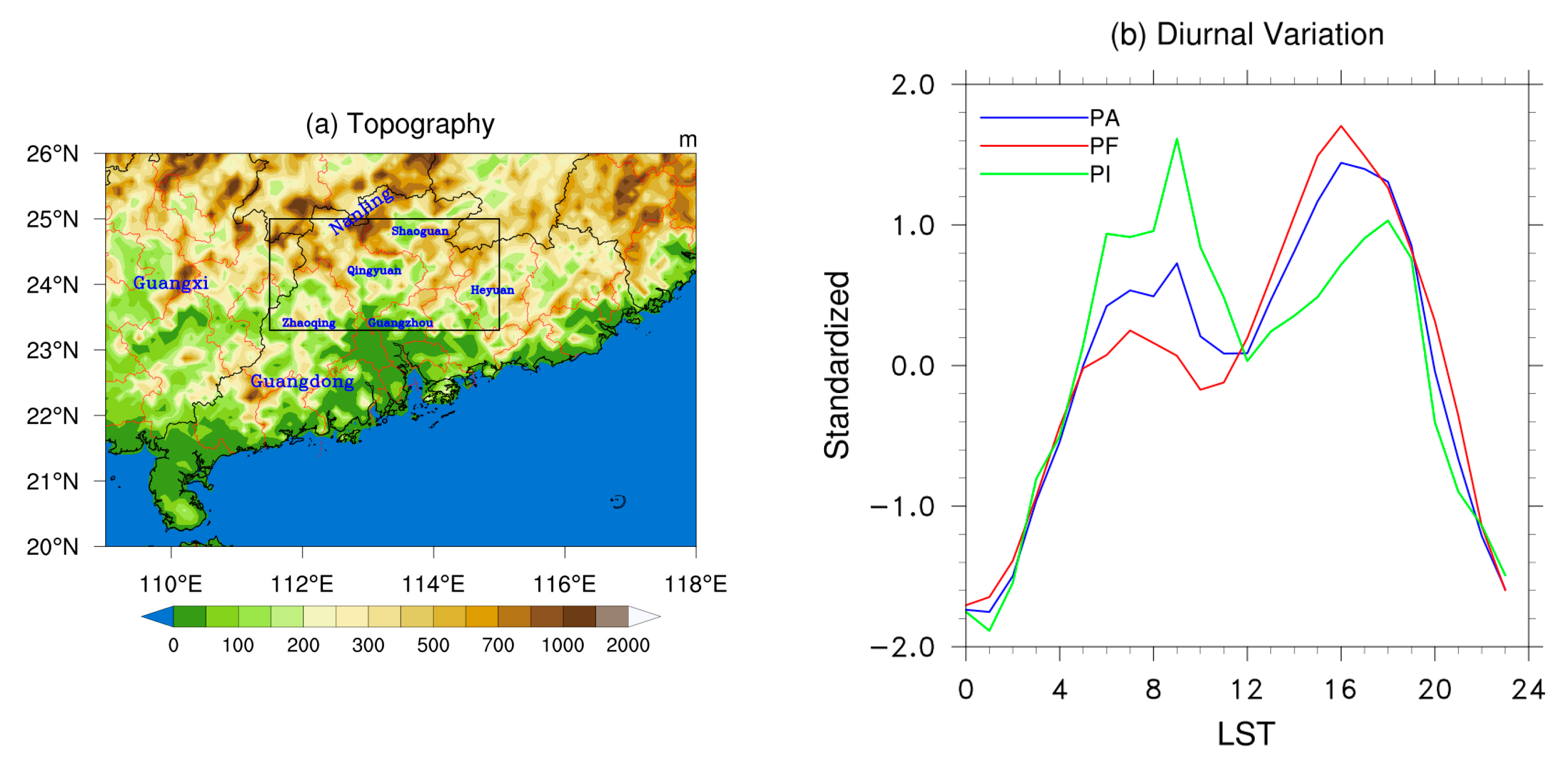
Figure 1. (a) Topography (m) in South China. The black rectangle denotes the target area in northern Guangdong. (b) Diurnal cycle (local standard time, LST) of mean standardized precipitation amount (blue line), frequency (red line), and intensity (green line) over inland Guangdong during the pre-summer period from 2008 to 2017.
Atmosphere 15 00023 g001
Figure 2. Spatial distribution of mean (a) precipitation amount (mm), (b) frequency (%), and (c) intensity (mm/h) in the morning (04–10 LST) during the pre-summer period from 2008 to 2017. The black rectangle denotes the target area in northern Guangdong.
Atmosphere 15 00023 g002
Figure 3. Spatial distribution of extreme precipitation amount (mm/7 h) and occurrence days in the morning (04–10 LST) during the (a,d) entire pre-summer period, (b,e) pre-monsoon onset period, and (c,f) post-monsoon onset period from 2008 to 2017. The black rectangle denotes the target area in northern Guangdong.
Atmosphere 15 00023 g003
Figure 4. The diurnal variation of MEP (shading, mm) and 850 hPa wind (vector, m/s) deviations with respect to daily means at 04 (a,b), 06 (c,d), 08 (e,f), and 10 (g,h) LST during the pre-monsoon onset period and post-monsoon onset period, respectively. The black rectangle denotes the target area in northern Guangdong.
Atmosphere 15 00023 g004
Figure 5. (a) First, (b) second, and (c) fourth SEOF modes of extreme precipitation amount at 02 LST during the pre-monsoon onset period. (d) is the first SEOF mode during the post-monsoon onset period. The black rectangle denotes the target area in northern Guangdong.
Atmosphere 15 00023 g005
Figure 6. The MEP evolution processes of the (ac) first, (df) second, (gi) third, and (jl) fourth groups (shading, mm/h) consistent with the SEOF mods in Figure 5 and the diurnal variation of 925 hPa winds (vector, m/s) (remove the daily mean) at 02, 06, and 10 LST. The black rectangle denotes the target area in northern Guangdong.
Atmosphere 15 00023 g006
Figure 7. (a) The diurnal variation of mean standardized precipitation amount of the Group 1 (red line), Group 2 (green line), Group 3 (black line), and all the MEP events (blue line) during the pre-monsoon onset period. (b) The same for Group 4 (red line) and all the MEP events (blue line) during the post-monsoon onset period.
Atmosphere 15 00023 g007
Figure 8. Time–longitude Hovmöller diagram of hourly rainfall diurnal variations (shading, mm/h) f of MEP events averaged from 23° N to 26° N from (a) Group 1, (b) Group 2, (c) Group 3, and (d) Group 4.
Atmosphere 15 00023 g008
Figure 9. Time–latitude Hovmöller diagram of hourly rainfall diurnal variations (shading, mm/h) of MEP events averaged from 111° E to 116° E from (a) Group 1, (b) Group 2, (c) Group 3, and (d) Group 4.
Atmosphere 15 00023 g009
Figure 10. The anomalous geopotential height (gpm, black contour) at 500 hPa and temperature (K, shading), moisture flux divergence (10−5 g/kg/s, black dashed contour), and winds (m/s, vectors, green vectors > 3 m/s) at 925 hPa in the morning (04–10 LST) for MEP in (a) group 1, (b) group 2, (c) group 3 during the pre-monsoon onset period, and (d) group 4 during the post-monsoon onset period. The thick blue dotted line denotes the leading edge of the anomalous southwesterly winds, where the anomalous southerly winds are zero. The anomalies are calculated as the averages in the four groups of MEP events minus the climatological mean states (2008–2017) during the pre-monsoon onset (G1–G3) and post-monsoon onset period (G4), respectively. The black rectangle denotes the target area in northern Guangdong.
Atmosphere 15 00023 g010
Figure 11. Vertical profiles of perturbation vertical circulation (vectors, zonal wind and 50 times vertical velocity, m·s−1), meridional winds (shading, m·s−1) and moisture flux divergence (negative, green line, 10−5 g·kg−1 s−1) and positive temperature (K) for different four groups with respect to their daily means at 02 LST (a,d,g,j), 06 LST (b,e,h,k), 10 LST (c,f,i,l) averaged from 23° N to 26° N.
Atmosphere 15 00023 g011
Figure 12. The anomalous convective available potential energy (CAPE, shading, J·kg−1) and convection inhibition (CIN, below -0 J·kg−1, green contours, J·kg−1) averaged from the morning time (04–10 LST) in (a) Group 1, (b) Group 2, (c) Group 3, (d) Group 4. The anomalies are calculated as the averages on the four groups of MEP minus the climatological averages (2008–2017) during the premonsoon onset (G1–G3) and post-monsoon onset period (G4), respectively. The black rectangle denotes the target area in northern Guangdong.
Atmosphere 15 00023 g012
Figure 13. Vertical profiles of CAPE generation rates by (a,e) boundary layer forcing (b,f) horizontal advection (c,g) vertical lifting (d,h) external heating for 6 h from initial to peak time averaged from 111.5 to 115° E in Group 1 and Group 3, respectively.
Atmosphere 15 00023 g013
Figure 14. Vertical profiles of CAPE generation rates by (a,e) boundary layer forcing (b,f) horizontal advection (c,g) vertical lifting (d,h) external heating for 6 h from initial to peak time averaged from 111.5 to –115° E in Group 2 and Group 4, respectively.
Atmosphere 15 00023 g014
Figure 15. Schematic diagrams of MEP over inland GD from (a) Group 1, (b) Group 2, (c) Group 3, and (d) Group 4.
Atmosphere 15 00023 g015
Table 1. The number of MEP events and the correlation coefficients at different times for four groups.
Number of MEP EventsCorrelation Coefficient with the Principal Mode
02 LST06 LST10 LST
Group 1320.9020.8930.865
Group 2130.6510.7200.509
Group 390.5560.7720.744
Group 4410.9200.9010.890
Disclaimer/Publisher’s Note: The statements, opinions and data contained in all publications are solely those of the individual author(s) and contributor(s) and not of MDPI and/or the editor(s). MDPI and/or the editor(s) disclaim responsibility for any injury to people or property resulting from any ideas, methods, instructions or products referred to in the content.