Abstract
This paper compares the synoptic-scale circulation and thermodynamic conditions of two representative heavy rainfall cases that were concentrated west of the Pearl River Estuary under different seasonal backgrounds. The first case occurred in the early rainy season, with strong precipitation lasting for several hours. The second case occurred in the late rainy season, with extreme flash downpour in just two hours. The analysis reveals that the main cause was different for the two rainfall cases. The main cause of the first rainfall case was converging polar cold air and marine warm air that formed a synoptic scale front that drove the strong ascent. The main cause of the second case was a cold backflow from the Taiwan Strait, resulting in a sharply contrasting equivalent potential temperature front and triggering very strong upward motion. The moist potential vorticity (MPV) showed a negative value before both rainstorms, indicative of the importance of convective instability. A sandwich-like configuration of the MPV led to the development of strong vertical motion for the second case.
1. Introduction
South China frequently suffers from heavy rainfall. Being adjacent to the South China Sea (SCS), moisture and energy are quite abundant in this area, which makes it one of the strongest heavy rain belts [1]. There are two main rainy seasons in South China, the early rainy (pre-rainy) season from April to June and the late (second) rainy season from July to September [2,3]. Most torrential rain happens in these six months, but there are differences in the properties between rainfall events in the early and late seasons. The rainfall frequency and intensity increase after the onset of the SCS summer monsoon around May 21 [4,5]. Heavy rainfall events during this period are mainly along the stationary South China front or in the warm sector [6,7]. The relevant systems in the late rainy season are usually monsoonal troughs and lows [8,9], especially tropical cyclones.
The great economic losses and casualties caused by extreme rainfall are indubitable [10]. For example, a sudden local torrential rainfall struck Guangzhou on 7 May 2017, causing more than 20,000 casualties and about a 177 million RMB loss [1]. Rain storms in cities lead to more casualties, as urbanization brings a denser population. Underground communal facilities, such as metros and culverts, become vulnerable in flash heavy rain events. Furthermore, excessive rain amounts during the rainy season result in rising water levels in lakes, rivers, and reservoirs [11]. Severe floods may lead to the erosion of farmland and even urban land. Damage to the environment and ecosystems may last for a long time.
The main types of rainfall events in South China are frontal precipitation, tropical cyclone (TC) precipitation, and strong convective activity. There is a special type of heavy rainfall, namely warm sector heavy rainfall (WSHR), in South China. WSHR is not directly affected by cold fronts and features strong precipitation with a relatively small coverage and sudden occurrence. Based on previous studies [12,13,14], WSHR can be divided into four types: wind shear, low vortex, southerly wind, and backflow. Although many studies have been conducted, the predictability of WSHR is still lower than other types of heavy rain, because its formation mechanism is not clearly understood. Another important precipitation source in South China is tropical cyclones. Rainfall events caused by TCs are more foreseeable, as TCs can be monitored quickly and clearly through satellites and other remote sensing technology. Therefore, scientific work on those highly uncertain and unexpected heavy rainfall events is particularly needed.
In the present study, we document and analyze two heavy rainfall cases in the Guangdong province, South China (the general location is shown later in large-scale circulation figures, with a red boundary line). The two cases share some common features. Firstly, the heavy rainfall areas were both concentrated west of the Pearl River Estuary (red dot). This is a densely populated area where heavy rainfall disasters cause great economic losses. Secondly, the accumulated precipitation was comparable and quite considerable (over 100 mm), causing urban waterlogging. However, under different seasonal backgrounds, the two cases exhibited differences in their precipitation characteristics and synoptic conditions. Thus, these two cases were chosen as respective high-impact representative cases west of the Pearl River Estuary in the early and late rainy seasons. By comparing the characteristics and reasons of these two typical cases, we intend to obtain a better understanding of the different types of rainfall events under different rainy seasons in South China. The rest of the paper is organized as follows. Section 2 introduces the data and method used in the study. Section 3 describes the temporal–spatial evolutions of the two heavy rainfall cases. The synoptic conditions of the two rainstorms are presented in Section 4. Their vertical profiles and moist potential vorticity (MPV) are analyzed in Section 5. The conclusions and discussion are provided in the final section.
2. Data and Methods
2.1. Data
The hourly station-observed rainfall on 3–4 May 2018 (the first case) and 8 September 2022 (the second case) were obtained from the China Meteorological Service. The automatic gauge stations are quite dense in the Guangdong Province and nearly 3000 stations’ data are used to show the evolutions of these two cases. The quality of the station data was well controlled and reliable. The present study utilizes hourly data from the ECMWF’s fifth-generation reanalysis (ERA5) [15] to describe the synoptic-scale features and perform the diagnostic analyses. ERA5 has a high spatial and temporal resolution, which makes it possible to reveal the local circulation evolution in a relative small area during the heavy rainstorm. The variables used include the geopotential height, zonal and meridional winds, vertical velocity, relative humidity, and temperature on 0.25° × 0.25° grids at pressure levels. The surface pressure was also used when we calculated the integral water vapor.
2.2. Methods
The equivalent potential temperature (theta-se) is a quantity that can reflect the thermodynamical environment. It defined as:
where is the temperature at pressure and is a reference pressure which is set as 1000 hPa; and represent the specific gas constants of dry air and water vapor, respectively; and are the specific heat capacities of the dry air and liquid water, respectively; and mean the total water and water vapor mixing ratios, respectively; H is the relative humidity; and is the latent heat of the vaporization of water [16].
When considering the mechanism of precipitation, especially that of heavy rainfall, the role of water vapor must be taken into account, leading to the concept of moist potential vorticity (MPV). From the conception of potential vorticity [17], replacing the potential temperature with the equivalent potential temperature, the MPV in the p coordinate can be expressed approximately as:
where is the vertical vorticity and is the Coriolis parameter. The unit of the MPV is PVU (1 PVU = 10−6·m2·s−1·K·kg−1). The MPV not only represents the dynamic and thermal property, but also includes the moist information [18,19]. A diagnosis of the MPV was made to reflect the relationship between the thermodynamic and water vapor conditions and precipitation.
The MPV is the sum of the barotropic term and baroclinic term, denoted as MPV1 and MPV2, respectively:
MPV1 is the product of the absolute vorticity and the vertical gradient of the equivalent potential temperature, indicating the roles of the inertial stability and convective stability. When the air mass is convectively unstable, > 0, and therefore MPV1 < 0 and vice versa. MPV2 is the baroclinic term, whose value is determined by the vertical shear of the wind (horizontal vorticity) and the horizontal gradient of the equivalent potential temperature, characterizing the wet baroclinicity of the atmosphere. An increase in the vertical wind shear or the horizontal wet baroclinicity lead to an increase in the vertical vorticity [20].
Bennets et al. [21] proposed that, when the MPV is negative, conditional symmetric instability may occur. Wu et al. [22] suggested that the move of a large positive MPV2 in the lower troposphere can be a tracer of low-level warm and wet air flow or vortex activities.
3. Evolutions of the Two Heavy Rainfall Cases
The evolutions of the rainfall process and accumulated precipitation for 3–4 May 2018 and 8 September 2022 are shown in Figure 1. Although the precipitation areas are not overlapped exactly, the two cases share some common characteristics. Both cases manifest localized flash heavy rain (>100 mm) in a certain stage (Figure 1b,c,f) and the maximum precipitation is scattered west of the Pearl River Estuary (Figure 1d,h). These are the reasons why we chose the two cases for a comparative analysis.
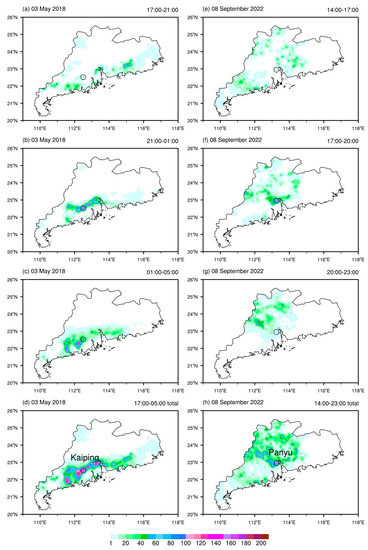
Figure 1.
Evolutions of the rainfall process and cumulative precipitation (units: mm) for (a–d) 3–4 May 2018 (the first case) and (e–h) 8 September 2022 (the second case). Black circles in left column (Kaiping station) and right column (Panyu station) denote the locations of two representative stations of the two cases, respectively.
The first case began along the edge of the coastline at around five o’clock on 3 May 2018. Then, a heavy rain band appeared west of the Pearl River and next, the heavy rainfall center moved southward and shrank gradually. As a result, the areas of the maximum cumulative precipitation in this process were centered southwest of the Pearl River Estuary. For the second case, at the beginning, the rainfall distribution was homogeneous in most parts of the Guangdong province (Figure 1e), but a spot of large rainfall suddenly appeared just west of the Pearl River Estuary (Figure 1f). The extreme heavy rain vanished quickly and the precipitation region moved northwestward. The highly localized rainfall rate was very strong and ranked the first in this area in terms of the accumulated precipitation amount.
Two automatic observation stations were chosen to show the hourly evolutions of the maximum rainfall in these two cases (Figure 2). One is a station in Kaiping City in the first case and the other is in the Panyu District in the second case. The locations of the two stations are shown as black circles in the left and right columns, respectively. The rain on 3 May 2018 was basically nocturnal and lasted until the next morning. The precipitation rate increased gradually in the first three hours and stabilized in the next three hours. The rainfall intensity decreased obviously before dawn. For the second case, there were only two spike rainy hours on the evening of 8 September 2022. The rainstorm poured more than 100 mm of rain in one hour at 19 and 20 o’clock, resulting in severe urban waterlogging. The local weather department issued a red-level (highest level) rainstorm warning and it was reported that the hourly precipitation in this event broke the record.
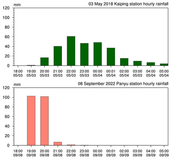
Figure 2.
Hourly evolutions of the precipitation (units: mm/h) from two representative gauge stations (black circles that are marked in Figure 1). Kaiping City for the first case in dark green (top panel) and Panyu District for the second case in salmon (bottom panel).
4. Synoptic Systems and Circulation Conditions
Thes synoptic-scale systems and circulation patterns were analyzed to reveal the favorable atmospheric conditions for the heavy rainfall events. Figure 3 shows the geopotential height at 500 hPa and wind fields at 200 hPa. For the first case, there was a powerful cold vortex over northeast China and the Sea of Japan, indicating that a strong cold event had just swept large parts of northern China. The deep East Asian trough was located mainly north of 30° N. The subtropical high was situated over tropical regions. South China was just at the northwest edge of the subtropical high, which is an unstable area (Figure 3a). The conditions were quite different in the second case. The entire middle and low latitudes of the Northern Hemisphere were under the subtropical high’s control. The South Asian High moved over the Tibet Plateau and South China was at the eastern flank of the upper-level divergence zones. A tropical cyclone appeared in the northwest Pacific off southeast Japan, but it was too far to exert effects on the Asian continent (Figure 3b). Upper-level divergence is a favorable factor for a rainstorm, but a subtropical high’s control is not. As the subtropical high controls a vast area, South China may be not the center of subsidence.
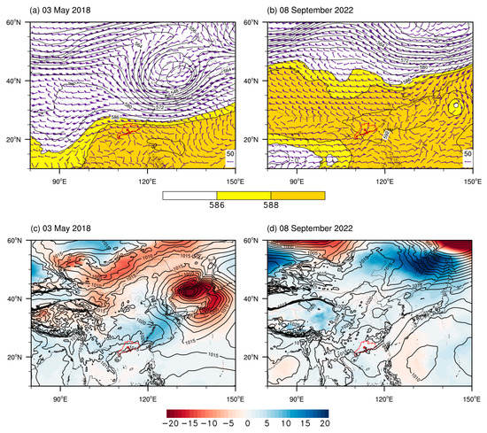
Figure 3.
(a,b) 500 hPa geopotential height (contours, regions higher than 588 are marked with yellow shadings; units: gpdm) and 200 hPa wind field (wind bars; units: m/s) and (c,d) sea level pressure (contours; units: hPa) and pressure departure in 24 h (shadings; units: hPa) for (a,c) the first and (b,d) the second cases. The red boundary line denotes the location of Guangdong Province and the red dot denotes Pearl River Estuary.
The sea level pressure and pressure departure within 24 h are shown in Figure 3c,d, respectively. In the first case, under a deep East Asia trough, cold air intruded into south China. The Guangdong Province was located at the rear of the surface high pressure with a warm–cold contrast in the north and south (Figure 3c). For the second case, the cold air activity was confined to northeast China and eastern Siberia. The pressure was quite homogeneous over the middle and low latitudes, which is not favorable for heavy rain. This also shows that heavy rainfall can happen under weakly forced synoptic conditions.
Thermodynamic conditions play a critical role in heavy rainfall events. The equivalent potential temperature, commonly referred to as theta-se, is a quantity that combines the temperature and humidity and is conservative in the moist processes when friction and diabatic heating are small on the synoptic scale. Therefore, it can be used to track air sources to some extent. The patterns of the theta-se and wind field at 850 hPa were examined (Figure 4). The first case displayed an obvious north–south warm–cold contrast, with northerly wind convergence along 25° N, where the high mountain range in the Guangdong Province, the Nanling Mountains, are located (Figure 4a). The second case was totally different from the first one. The theta-se showed nearly a west–east contrast. A distinct cold tongue with strong winds along the Taiwan Strait intruded into the expanse of heated areas (Figure 4b). The different contrast patterns imply the different stages of cold air activities and these were coincident with the distribution of the sea level pressure and its departure. It is also noted that thermal conditions are not same under different seasonal backgrounds. In May, the equivalent potential temperature over the SCS is milder than that over the South China coast. When cold air arrives from north, the meeting of cold air mass and warm air mass over the South China continent forms a large-scale front. The temperature distribution features triple bands and the continent is the warmest. In September, after a long time of subsidence induced by strong diabatic heating because of subtropical highs [23], vast low latitudes are uniformly hot. Thus, the second case can be considered as the backflow type of warm sector heavy rainfall.
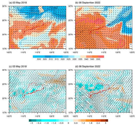
Figure 4.
(a,b) 850 hPa equivalent potential temperature (shadings; units: K) and wind field (vectors; units: m/s) and (c,d) integral water vapor flux (vectors; units: kg/m·s) and its divergence (shadings; units: 10−5 kg/m2·s) for (a,c) the first and (b,d) the second cases. The red boundary line denotes the location of Guangdong Province.
Next, we calculated the vertically integral water vapor flux and its divergence [24], and the results are presented in Figure 4c,d. The moisture transport and water vapor sink corresponding with the heavy rain center were prominent enough to be recognized. In the second case, the pattern of the water vapor flux resembles that of a low-level wind field and potential temperature (Figure 4d), indicating that the backflow from the Taiwan Strait is not only an equivalent potential temperature front, but also a water vapor front. The moisture transportation in the first case showed an interesting path, rotating clockwise around the heavy precipitation region (Figure 4c). Although the flux values were not very large, the heavy rain zone received water vapor from all sides of the rainfall region.
5. Vertical Structure and MPV Diagnosis
We examined the vertical profiles to compare the similarities and differences of the two storms. The positive vorticity center was detected at a low level in the first case, especially at the beginning, whereas the rotational feature was very weak in the second case. In the first case, the distributions of the divergence matched with those of the vorticity, being convergent at a lower level and divergent at the negative vorticity area of an upper level, inducing a strong ascent (Figure 5b). Although there was a weak signal of vorticity, the second case showed a remarkable strong upward motion (Figure 5c,d). Negative vertical velocity rushed to the top of the troposphere and it was much stronger than that in the first case. Such a strong updraft resulted in a downpour within a short time. In comparison, the vertical motion in the first case was relatively weaker and the precipitation process lasted longer. As the foregoing analysis implied the important role of the equivalent potential temperature contrast, the vertical profiles of this physical quantity were made. The shadings in Figure 5 show the pressure-latitude (longitude) cross-sections of the theta-se in the respective ascent centers of the two cases. Although both cases displayed a warm and cold contrast, the inclination of the second case was much more steep and contrasting. When the northeasterly cold tongue from the Taiwan Strait encountered warm and moist air, the sharp thermal contrast made the heat release and triggered a strong upward motion, causing sudden localized heavy rain.
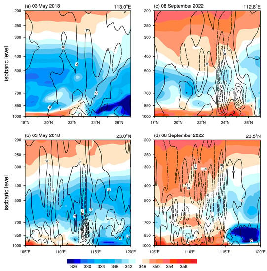
Figure 5.
Pressure-latitude (longitude) cross-sections of equivalent potential temperature (shadings; units: K) and vertical p-velocity (contours; units: 0.01 Pa s−1) for (a,b) the first and (c,d) the second cases.
Figure 6 shows the result of the MPV diagnosis of the two cases. A clear negative value of the MPV1, indicating potential instability [20], can be seen below 700 hPa before the precipitation and this signal appeared several hours in advance, especially for the first case. The positive MPV1 followed, which indicated the southward intrusion of cold dry air. Coupled with the strong negative MPV1 at a low level, convection consequently developed. For the second case, there were three negative and positive centers in the vertical direction, like a sandwich (Figure 6c). This distribution may have enabled upward motion to develop further after the convective instability energy was released by the lower and middle layer configurations. The enhancement of the positive MPV2 reflects the strengthening of the low-level warm-wet air flow. The magnitude of this term depended on the vertical wind shear and horizontal gradient of the theta-se. The larger the value was, the stronger the atmospheric baroclinicity became. This baroclinicity can be converted into barotropic potential vorticity disturbance, which is favorable for cyclonic vorticity growth. As the rotation feature in the second case was not as obvious as that in the first one, the MPV2 was confined in the surface layer and persisted for a shorter time.
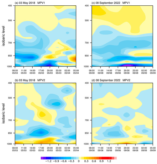
Figure 6.
MPV (units: PVU) diagnosis results of the respective ascent centers for the first (23.0° N, 113.0° E, (a,b)) and the second cases (23.5 °N, 112.8° E, (c,d)).
6. Conclusions and Discussion
The present paper documented and compared two heavy rainfall cases in the Guangdong province under different seasonal backgrounds. The early rainy season in South China is the transition period of winter to summer and most rainfall is contributed by a large-scale front, which is the typical and dominant influencing system. The heavy rainfall in the first case was caused by the meeting of polar cold air mass and marine warm air mass. The warm–cold contrast was in the south to north direction. Under the northwest edge of the subtropical high, perturbations in the middle troposphere helped the occurrence of developing convective systems too. The second case can be roughly classified into the backflow type of warm sector heavy rainfall. Different from the first case that happened in the early rainy season, the subtropical high was overwhelming in the second case. This case happened under weakly forced synoptic conditions and the obvious cold equivalent potential temperature backflow from the Taiwan Strait played a key role. Strong cold–warm and dry–wet contrasts triggered strong upward motion. Adequate energy in coastal areas also helped the convective instability in the atmosphere. These conditions resulted in a higher precipitation efficiency in a short time for the second case.
The diagnosis of the moist potential vorticity (MPV) suggests that a negative MPV1 may be a predictor of heavy rain, especially when there is a southward intrusion of cold dry air. An extra negative unstable layer above may trigger a stronger ascending motion. Consistent with the previous research results [18,20], a low-level negative sign of MPV1 appears about a few hours earlier before heavy rain. As a potential predictor, it may be useful for short-term forecasting. Combining atmospheric dynamics, thermal properties, and the role of water vapor, the MPV can be used to study the development of the vertical vorticity in the vortex in the wet baroclinicity process. However, it should be noted that the research and work on the applicability of MPV diagnoses are not sufficient enough. Further studies are needed in the future.
Sun et al. [1] found that backflow-type events often occur in the coastal regions of the Pearl River Delta in the Guangdong Province during spring. The second case gives a good example of this finding, but for a different occurrence time. Previous studies [1,25] have suggested that dynamic forcing plays a more important role than thermal forcing. However, the second case showed a counterexample, though it was not strictly a backflow type. Here, we want to emphasize that the record-breaking hourly precipitation case was caused by a temperature front. This may provide a benefit for advancing our knowledge of heavy rainfall events in South China. Located at the southernmost part of the Asian continent and facing the SCS, the thermal difference between land and sea favors heavy rainfall formation. Previous studies [26,27] have observed that many heavy rainfall events in South China occur along its coastlines or in the offshore areas adjacent to coastal mountains. Some events show nocturnal characteristics and the first case of this study conformed to this feature. The terrain enhancement effect is a non-negligible factor during a heavy rainfall process [28]. According to the topography distribution of the Guangdong province, there are mountain ridges west of the Pearl River Estuary along the coastal areas, but it is an alluvial plain near the estuary. In the first case, local orographic lifting may have enhanced the precipitation, while in the second case, the urbanization heating effect of Guangzhou may have contributed to the flash heavy rainfall. This study focused on synoptic-scale circulation and thermodynamic conditions. A better understanding of the intricate structural features of heavy rainfall needs more work on mesoscale convective systems (MCSs), such as convection initiation [29] and low-level jets [30].
Author Contributions
Conceptualization, Y.J. and T.X.; writing—original draft preparation, Y.J.; writing—review and editing, R.W. and X.Y.; visualization, Y.J. and T.X. All authors have read and agreed to the published version of the manuscript.
Funding
This study was supported by the Guangzhou science and technology planning project [grant number 2023A04J1546].
Institutional Review Board Statement
Not applicable.
Informed Consent Statement
Informed consent was obtained from all subjects involved in the study.
Data Availability Statement
The hourly station rainfall data in Guangdong Province were derived from the China Meteorological Administration operational network and were available upon request. ERA5 reanalysis datasets used in this study are freely available for public from ECMWF Climate Data Store. Data on pressure levels are accessed on URL https://cds.climate.copernicus.eu/cdsapp#!/dataset/reanalysis-era5-pressure-levels?tab=form (accessed on 9 September 2022). Data on single levels are accessed on URL https://cds.climate.copernicus.eu/cdsapp#!/dataset/reanalysis-era5-single-levels?tab=form (accessed on 9 September 2022).
Conflicts of Interest
The authors declare no conflict of interest.
References
- Sun, J.; Zhang, Y.; Liu, R.; Fu, S.; Tian, F. A Review of Research on Warm-Sector Heavy Rainfall in China. Adv. Atmospheric Sci. 2019, 36, 1299–1307. [Google Scholar] [CrossRef]
- Ding, Y. Summer Monsoon Rainfalls in China. J. Meteorol. Soc. Jpn. Ser. II 1992, 70, 373–396. [Google Scholar] [CrossRef]
- Ding, Y.; Wang, Z. A study of rainy seasons in China. Meteorol. Atmospheric Phys. 2008, 100, 121–138. [Google Scholar] [CrossRef]
- Hu, P.; Chen, W.; Huang, R. Role of tropical intraseasonal oscillations in the South China Sea summer monsoon withdrawal in 2010. Atmos. Sci. Lett. 2018, 19, e859. [Google Scholar] [CrossRef]
- Hu, P.; Chen, W.; Chen, S.; Liu, Y.; Huang, R. Extremely Early Summer Monsoon Onset in the South China Sea in 2019 Following an El Niño Event. Mon. Weather. Rev. 2020, 148, 1877–1890. [Google Scholar] [CrossRef]
- Rao, J.; Xie, J.; Cao, Y.; Zhu, S.; Lu, Q. Record Flood-Producing Rainstorms of July 2021 and August 1975 in Henan of China: Comparative Synoptic Analysis Using ERA5. J. Meteorol. Res. 2022, 36, 809–823. [Google Scholar] [CrossRef]
- Du, Y.; Chen, G. Heavy Rainfall Associated with Double Low-Level Jets over Southern China. Part I: Ensemble-Based Analysis. Mon. Weather. Rev. 2018, 146, 3827–3844. [Google Scholar] [CrossRef]
- Jiang, J.; Jiang, J.; Bu, Y.; Liu, N. Heavy rainfall associated with monsoon depression in South China: Structure analysis. Acta Meteorol. Sin. 2007, 65, 537–549. (In Chinese) [Google Scholar] [CrossRef]
- Meng, W.; Zhang, Y.; Yuan, J.; Li, C.; Liang, Q.; Wu, N. Monsoon trough and MCSs interactions during the persistent torrential rainfall event of 15–18 July 2011 along the South China coast. Acta Meteor. Sin. 2014, 72, 508–525. (In Chinese) [Google Scholar] [CrossRef]
- Easterling, D.; Evans, J.; Groisman, P.; Karl, T.; Ambenje, P. Observed variability and trends in extreme climate events: A brief review. Bull. Am. Meteor. Soc. 2000, 81, 417–426. [Google Scholar] [CrossRef]
- Qian, W.; Li, J.; Shan, X. Application of synoptic-scale anomalous winds predicted by medium-range weather forecast models on the regional heavy rainfall in China in 2010. Sci. China Earth Sci. 2013, 56, 1059–1070. [Google Scholar] [CrossRef]
- He, L.; Chen, T.; Kong, Q. A review of studies on prefrontal torrential rain in South China. J. Appl. Meteor. Sci. 2016, 27, 559–569. (In Chinese) [Google Scholar] [CrossRef]
- Miao, C.; Yang, Y.; Wang, J.; Li, P. A comparative study on characteristics and thermo-dynamic development mechanisms of two types of warm-sector heavy rainfall along the South China coast. J. Trop. Meteor. 2018, 24, 494–507. [Google Scholar] [CrossRef]
- Liu, R.; Sun, J.; Chen, B. Selection and classification of warm-sector heavy rainfall events over South China. Chin. J. Atmos. Sci. 2019, 43, 119–130. (In Chinese) [Google Scholar] [CrossRef]
- Hersbach, H.; Bell, B.; Berrisford, P.; Hirahara, S.; Horányi, A.; Muñoz-Sabater, J.; Nicolas, J.; Peubey, C.; Radu, R.; Schepers, D.; et al. The ERA5 global reanalysis. Q. J. R. Meteorol. Soc. 2020, 146, 1999–2049. [Google Scholar] [CrossRef]
- Xu, P.; Wang, L.; Ming, J. Central Asian Precipitation Extremes Affected by an Intraseasonal Planetary Wave Pattern. J. Clim. 2022, 35, 2603–2616. [Google Scholar] [CrossRef]
- Hoskins, B.J.; McIntyre, M.E.; Robertson, A.W. On the use and significance of isentropic potential vorticity maps. Q. J. R. Meteorol. Soc. 2007, 111, 877–946. [Google Scholar] [CrossRef]
- Gao, S.; Zhou, Y.; Cui, X.; Dai, G. Impacts of cloud-induced mass forcing on the development of moist potential vorticity anomaly during torrential rains. Adv. Atmos. Sci. 2004, 21, 923–927. [Google Scholar] [CrossRef]
- Shou, S. Theory and application of potential vorticity. Meteor. Mon. 2010, 36, 9–18. (In Chinese) [Google Scholar]
- Wang, H.; Shou, S.; Wang, W.; Ma, F. Diagnostic analysis of moist potential vorticity for local heavy rain. J. Nat. Disaster 2009, 18, 129–134. (In Chinese) [Google Scholar] [CrossRef]
- Bennetts, D.A.; Hoskins, B.J. Conditional symmetric instability—A possible explanation for frontal rainbands. Q. J. R. Meteorol. Soc. 1979, 105, 945–962. [Google Scholar] [CrossRef]
- Wu, G.; Cai, Y.; Tang, X. Moist potential vorticity and slantwise vorticity development. Acta Meteor. Sin. 1995, 4, 387–405. (In Chinese) [Google Scholar] [CrossRef]
- Liu, B.; Chen, G.; Zeng, W.; Bai, L.; Qin, H. Diurnal Variations of Southerly Monsoon Surge and Their Impacts on East Asian Summer Rainfall. J. Clim. 2022, 35, 159–177. [Google Scholar] [CrossRef]
- Banacos, P.C.; Schultz, D.M. The Use of Moisture Flux Convergence in Forecasting Convective Initiation: Historical and Operational Perspectives. Weather Forecast. 2005, 20, 351–366. [Google Scholar] [CrossRef]
- Liu, X.; Luo, Y.; Guan, Z.; Zhang, D.-L. An Extreme Rainfall Event in Coastal South China During SCMREX-2014: Formation and Roles of Rainband and Echo Trainings. J. Geophys. Res. Atmos. 2018, 123, 9256–9278. [Google Scholar] [CrossRef]
- Bai, L.; Chen, G.; Huang, L. Convection Initiation in Monsoon Coastal Areas (South China). Geophys. Res. Lett. 2020, 47, e2020GL087035. [Google Scholar] [CrossRef]
- Chen, X.; Zhao, K.; Xue, M. Spatial and temporal characteristics of warm season convection over Pearl River Delta region, China, based on 3 years of operational radar data. J. Geophys. Res. Atmos. 2014, 119, 12–447. [Google Scholar] [CrossRef]
- Bai, L.; Chen, G.; Huang, Y.; Meng, Z. Convection Initiation at a Coastal Rainfall Hotspot in South China: Synoptic Patterns and Orographic Effects. J. Geophys. Res. Atmos. 2021, 126, e2021JD034642. [Google Scholar] [CrossRef]
- Zhang, S.; Liang, Z.; Wang, D.; Chen, G. Nocturnal Convection Initiation over Inland South China during a Record-Breaking Heavy Rainfall Event. Mon. Weather. Rev. 2022, 150, 2935–2957. [Google Scholar] [CrossRef]
- Gebauer, J.G.; Shapiro, A.; Fedorovich, E.; Klein, P. Convection Initiation Caused by Heterogeneous Low-Level Jets over the Great Plains. Mon. Weather. Rev. 2018, 146, 2615–2637. [Google Scholar] [CrossRef]
Disclaimer/Publisher’s Note: The statements, opinions and data contained in all publications are solely those of the individual author(s) and contributor(s) and not of MDPI and/or the editor(s). MDPI and/or the editor(s) disclaim responsibility for any injury to people or property resulting from any ideas, methods, instructions or products referred to in the content. |
© 2023 by the authors. Licensee MDPI, Basel, Switzerland. This article is an open access article distributed under the terms and conditions of the Creative Commons Attribution (CC BY) license (https://creativecommons.org/licenses/by/4.0/).