1. Introduction
Deep convective cloud systems in the tropics and sub-tropics often contain regions with a high mass concentration of ice particles at high altitudes. For jet aircraft, these regions of high ice water content (HIWC) may cause engine power loss events and engine damage due to ice crystal icing (ICI) [
1,
2,
3,
4]. The ice particles may also accumulate in air data probes, causing anomalies in the output that can impact operations of the flight management system and maintaining flight control [
5,
6]. These impacts are a function of the concentration and path length for the aircraft. The characteristics of these HIWC regions can vary significantly and the associated conditions may appear benign to pilots with no significant radar echoes due to small ice particle size, little or no lightning or turbulence, and no airframe icing. Bravin and Strapp (2019) [
4] analysed 174 ICI engine events (including power loss, damage, and high vibration) recorded in a Boeing event database. They show there is a wide geographical distribution of events across the tropics and sub-tropics, both oceanic and continental, with maxima over North America, South America, Africa, and the Southeast Asia/maritime continent region. It has also been shown that engine events can result from prolonged exposure to moderate values of ice water content (IWC) (0.5 < IWC < 1.0 g m
−3) as well as short exposure times at high values (≥1.0 g m
−3) of IWC. In a more recent study, Rugg et al. (2021) [
7] used 11 years of IWC retrievals from CloudSat and CALIOP satellite data to provide a first estimate of the global distribution of HIWC frequency based on a threshold of at least 1.0 g m
−3. These results also show maxima in South America, Africa, and the Southeast Asia/maritime continent region.
In recent years, there has been an international collaboration between the European High Altitude Ice Crystal (HAIC) Project and the USA-led High Ice Water Content (HIWC) project directed at characterising the ice-crystal environment, better understanding the fundamental cloud physics in deep convection, understanding critical engineering issues associated with ICI in jet engines, developing new certification standards for engines and air data probes, and developing strategies to mitigate the risks to international aviation [
8,
9,
10]. The work included flight campaigns with instrumented research aircraft out of Darwin, Australia, in 2014; Cayenne, French Guiana, in 2015; and Fort Lauderdale, Florida, USA, in 2015. Additional research flights were conducted from Fort Lauderdale, Florida, Palmdale, California, and Kona, Hawaii in 2018. In situ observations of IWC were collected during these flights. The work also included development of nowcasting techniques to identify potential areas of HIWC and enable the provision of guidance to better support flight operations and manage a tactical response [
11,
12,
13,
14].
The Algorithm for Prediction of HIWC Areas (ALPHA) [
14] (hereafter referred to as H2020) was developed by the U.S. National Center for Atmospheric Research (NCAR) with funding support from the U.S. Federal Aviation Administration (FAA). This application uses a combination of numerical weather prediction (NWP) model data, satellite data, and radar data (where available), to identify the likely presence of HIWC with data collected during the HAIC-HIWC field campaigns used in the development. A key objective with this development is the provision of near-real-time guidance based on meteorological information that has wide coverage, is routinely available, and has appropriate spatial and temporal resolution.
Following development of ALPHA, the Australian Bureau of Meteorology (hereafter referred to as the Bureau) collaborated with NCAR, FAA, and Australian-based airlines to trial ALPHA for an area across Indonesia, Papua New Guinea (PNG), and northern Australia. The application was adapted to ingest data from the Bureau’s Australian Community Climate and Earth Simulation System (ACCESS) model [
15] and the Japan Meteorological Agency (JMA) Himawari-8 (H8) geostationary meteorological satellite [
16]. Available radar data coverage across the trial domain is very limited; thus, it is not used.
Arrangements were made for the dissemination and visualisation of the trial HIWC product from ALPHA in the Bureau National Operations Centre and the Australian airlines Qantas and Virgin Australia. Initially, the trial objectives included evaluation by airline operations personnel (including pilots, flight planning, and flight operations) and consideration of the product utility for maintaining situational awareness and flight monitoring, input to further development of the HIWC product to address user needs, and input to the development of standards and recommended practices proposed for HIWC guidance for the international aviation industry. These objectives were severely impacted by the COVID-19 pandemic in early 2020. With access to airline operations personnel and their feedback on product utility no longer available, the trial objectives were re-scoped to focus on performance evaluation and potential utility of the product for maintaining situational awareness and flight monitoring. Validation of the HIWC product was undertaken by comparing it with data from the NASA polar-orbiting CloudSat satellite, from which vertical profiles of IWC can be retrieved.
In
Section 2, we describe the HIWC product, including the input meteorological data and associated processing.
Section 3 reviews validation of ALPHA during its initial development and outlines the methodology for independent validation made possible for this trial with improved retrievals of IWC from the CloudSat satellite.
Section 4 presents details on the operational setup for the ALPHA trial. This included determination of the trial domain, adaptation of ALPHA to ingest and process the ACCESS model and satellite data from the Bureau, and arrangements for dissemination of the HIWC product to stakeholders. Results from the validation are presented in
Section 5, with a detailed case study for an event on 7 January 2020 and an overall performance evaluation comparing the HIWC product with profiles of IWC for 397 daytime CloudSat passes during the observation period. In
Section 6, we discuss the outcomes of the ALPHA trial and the implications for development and provision of operational advisories for HIWC.
2. HIWC Product Description
Atmospheric conditions associated with ICI engine events span a range of temperatures, flight altitudes, and convective storm types. Analyses have shown that common attributes make the identification of HIWC conditions potentially feasible using routinely available meteorological data [
3,
17]. Using observations of meteorological conditions associated with these events along with research aircraft measurements of IWC, ALPHA was developed to diagnose areas of suspected HIWC conditions. Lacking a rigorous physical understanding of the processes which lead to hazardous concentrations of ice crystals, a machine learning approach was employed to estimate the potential for HIWC conditions.
Fuzzy logic provides a framework for the optimal combination of a set of variables to solve decision-making problems where there is uncertainty, with applications in a wide range of areas [
18]. As discussed in H2020 [
14], ALPHA uses a set of critical meteorological variables derived from satellite, NWP model, and radar (where available) data together with fuzzy logic methods to identify areas with a likely presence of HIWC. The satellite-based component of the algorithm locates high, cold cloud tops with a large cloud optical depth (COD). NWP model fields are used to identify areas of potential convection using updrafts, convective precipitation, and condensate fields. Model temperature profiles bound the vertical extent of glaciated cloud conditions. The radar component of ALPHA detects active updrafts, high radar reflectivity, and the height of the convective clouds. The “three-input” version of ALPHA is based on satellite, model, and radar data (where available), and the “two-input” version is based on satellite and model data only. For this trial, the “two-input” version of ALPHA was used due to the limited availability of radar data across the domain. The lack of radar data in the “two-input” version means it is not possible to provide information on the vertical structure of HIWC that is possible in the “three-input” version. In situ measurements of IWC by research aircraft during field campaigns were used in training the algorithm with a machine learning technique. A significant challenge is how well the algorithm delineates the boundaries of HIWC areas due to spatial and temporal variability in the associated cloud characteristics. Hence, there will be increased uncertainty around the edges of HIWC features.
Fuzzy logic membership functions are probabilistic or heuristic relationships between a single variable and the presence of HIWC. When applied to an input field it is transformed into an interest field with values in the interval [0,1] forming a member of a fuzzy set. The interest fields for a set of variables can then be aggregated using a weighted sum that is optimised to generate an interest field for each data type. The interest fields for the data types are further aggregated with a weighted sum to create a 3-dimensional diagnosis of HIWC Potential with values in the range [0,1], where 0 represents minimum likelihood of HIWC and 1 represents maximum likelihood. The complete set of membership function parameters and optimised weights for the variables used in ALPHA are presented in H2020 [
14] at Tables 2 and 3.
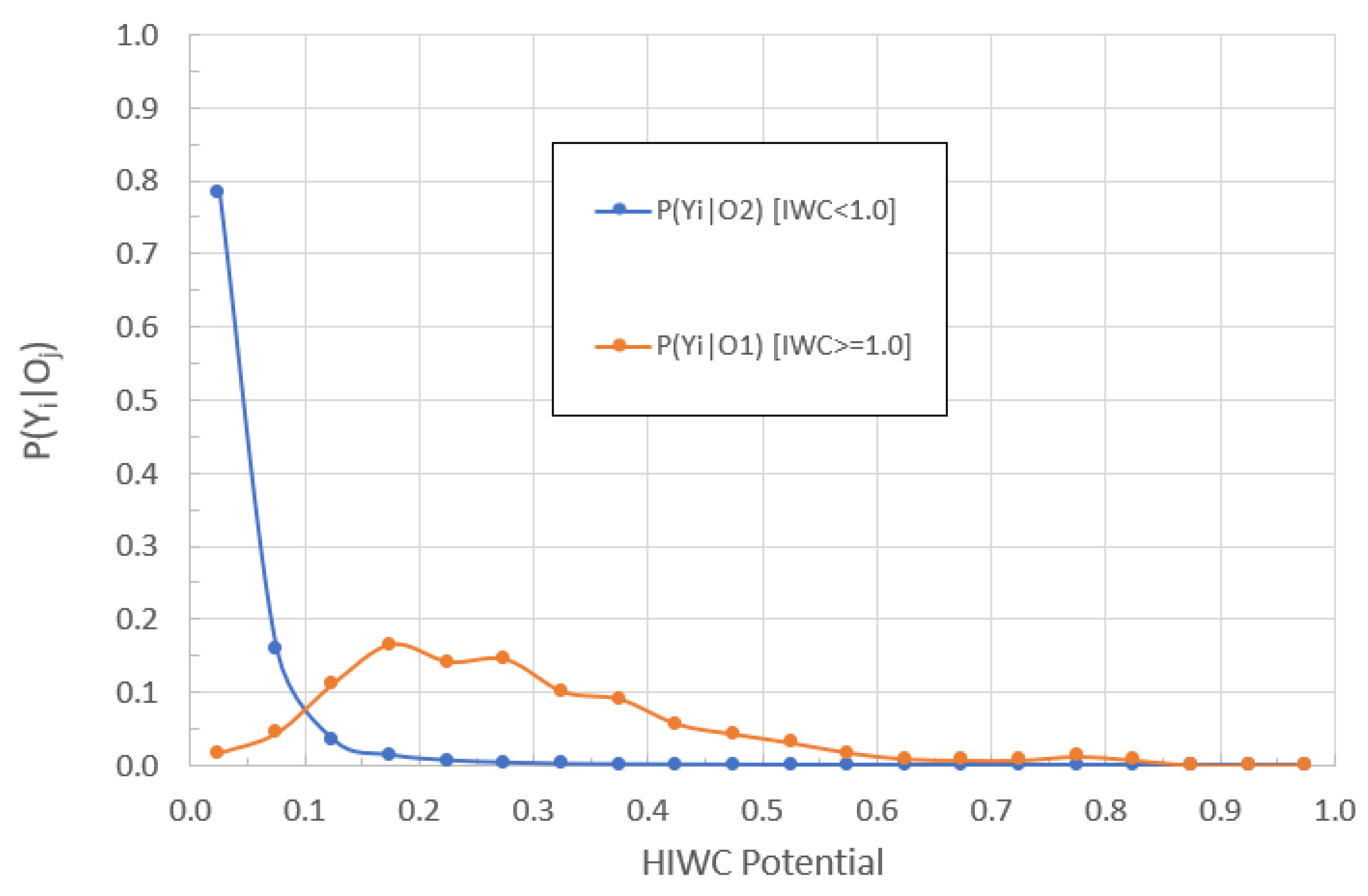
To illustrate, the in situ observations of IWC from research flights together with associated satellite observations and derived variables were used to derive fuzzy membership functions for the daytime satellite interest field. The function parameters are presented in
Table 1, with graphical formats shown in
Appendix A (
Figure A1).
Figure A1 also shows the distribution for the in situ observations of IWC associated with each of the variables. They show higher values for the COD, and colder cloud top temperatures are associated with higher IWC.
Table 1 shows that the transformed COD is equal to 0 for values less than 16.2; for values greater than or equal to 129.2 it is 1, and there is a linear interpolation for intermediate values. For CTT and the 10.8 µm brightness temperature (BT10), the sign is negative, so the transformed variable is equal to 1 for values less than the lower threshold and 0 for values greater than or equal to the upper threshold.
Given the large number of data types and associated variables, a machine learning technique, known as particle swarm optimisation (PSO), was applied to tune ALPHA, and this is detailed in H2020 [
14]. This multi-parameter optimisation technique was adapted to objectively select specific input variables and exclude others, define piecewise linear membership functions with associated inflection points, and determine weighting factors for optimal aggregation of the interest fields for the input variables and the intermediate data types [
14]. The in situ measurements of IWC collected during field campaigns and other associated observations were used to guide the PSO process.
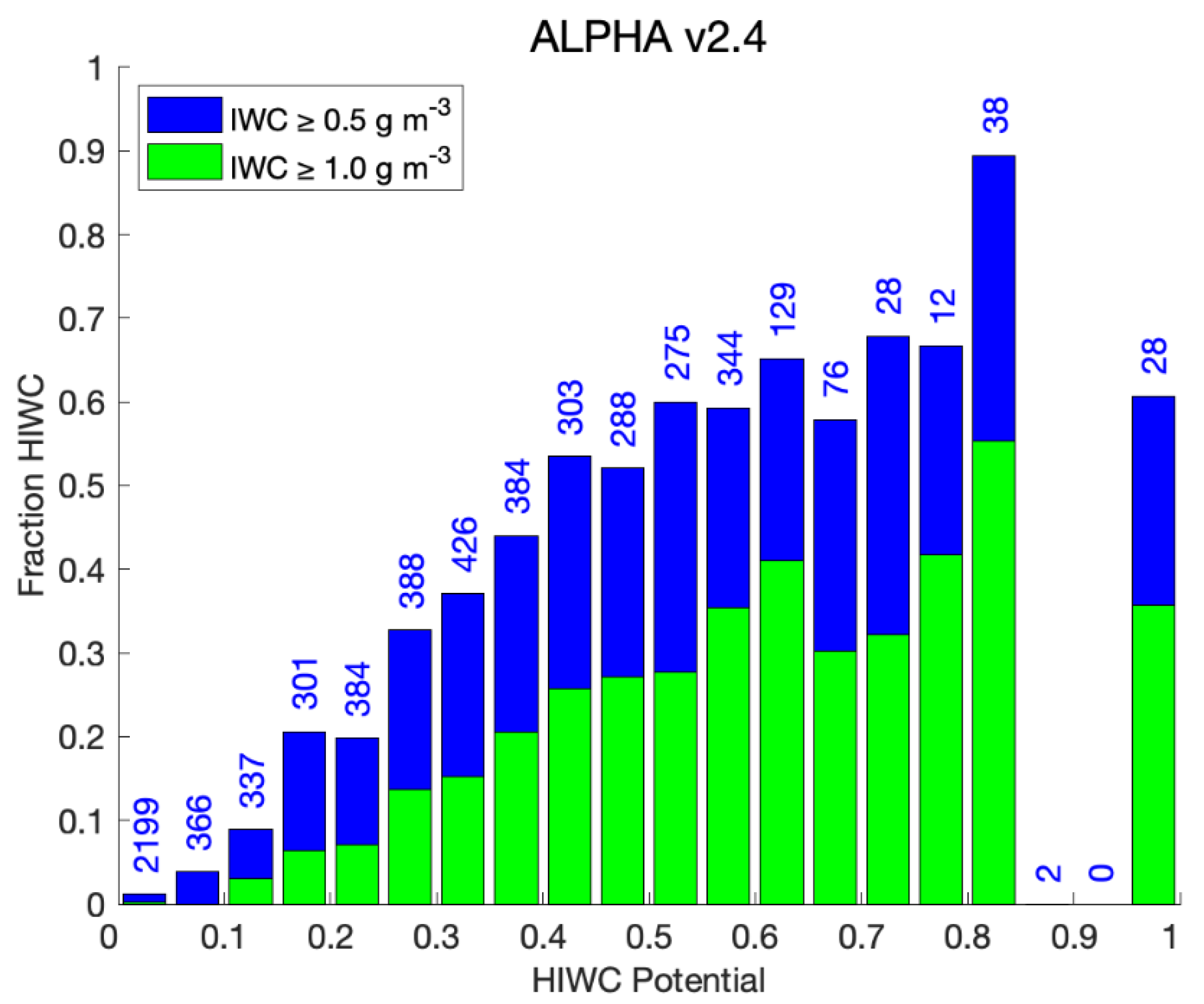
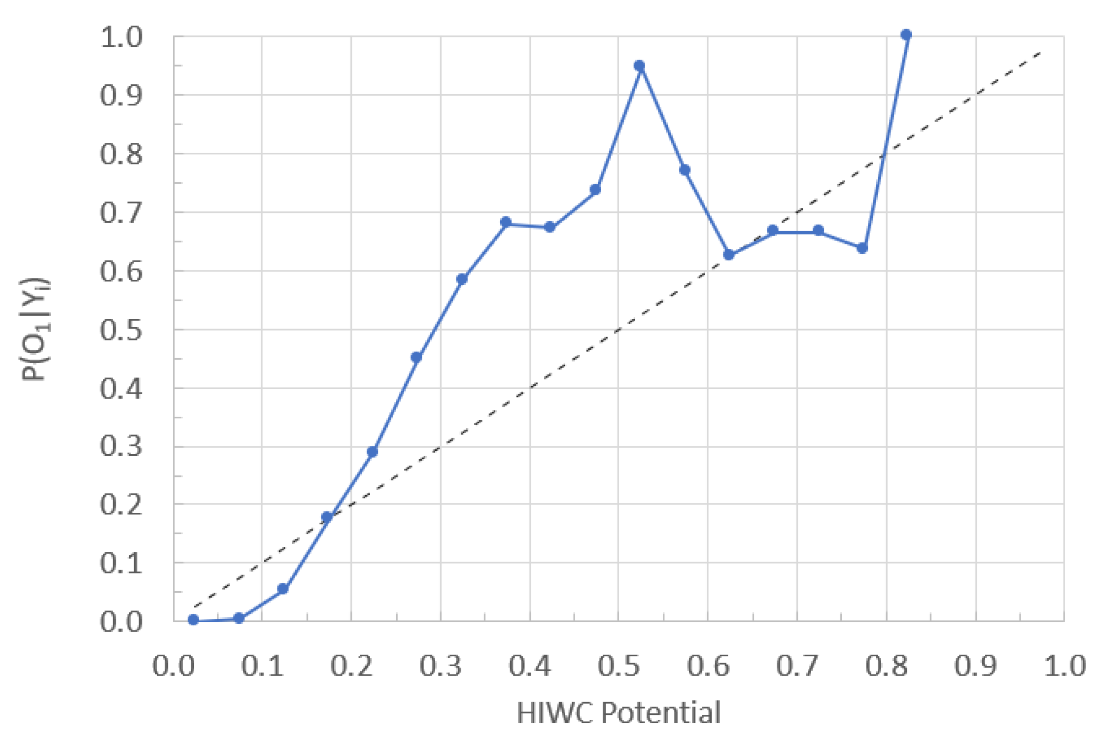
The ALPHA product is a three-dimensional grid of the uncalibrated potential for clouds to contain high concentrations of ice particles (more than 0.5 g m−3). Values of the HIWC Potential lie in the range 0–1, with higher values indicating an increased probability of encountering ice water content above the 0.5 g m−3 threshold. As the “two-input” version of ALPHA was used, there is no variation in the vertical structure for HIWC Potential, apart from the upper and lower bounds. The product is currently an analysis at the time of observation, and a short-term nowcast is not yet provided.
4. Operational Implementation
For this trial, the latest two-input version of ALPHA (v2.4) was adapted to ingest data from the Bureau’s regional version of the Australian Community Climate Earth System Simulator model (ACCESS-R) [
15,
22] and the JMA H8 satellite [
16].
Intensive operations were conducted in the period October 2019–March 2020 inclusive, with the following objectives:
To provide aviation industry stakeholders, including Bureau forecasters and airlines, with the HIWC product for evaluation.
To inform further improvements to ALPHA.
To inform a decision on provision of an operational HIWC nowcasting product.
To progress the development of standards and recommended practices for the provision of HIWC guidance required by the international aviation industry.
The Bureau’s regional ACCESS-R model is nested in the global ACCESS-G model and has a horizontal domain that covers the Australian mainland and surrounding areas, extending well beyond the ALPHA trial domain. The horizontal resolution is 0.11° × 0.11°, and there are 70 levels in the vertical with a top around 80 km. The model runs on a six-hour cycle and data files were routinely generated for ingestion by ALPHA with the relevant forecast fields provided at hourly time steps. The ACCESS-R fields used in ALPHA and associated fuzzy logic membership function parameters and weights are presented at
Table 2 in H2020 [
14].
The H8 satellite data is received every 10 min and is pre-processed to generate data files containing observed and derived parameters for ingestion by ALPHA. The spatial resolution of these data is interpolated to 0.02 degrees. A different blend of data fields, fuzzy logic membership functions, and weights are used for daytime and night-time hours (H2020,
Table 2 [
14]). The derived satellite parameters were generated using the Geostationary Cloud Algorithm Testbed (GEOCAT) application developed at NOAA NESDIS (
http://cimss.ssec.wisc.edu/csppgeo/geocat.html, accessed on 15 April 2023) which is a software framework for running science algorithms. The derived parameters used in ALPHA included cloud top temperature (CTT) and cloud top height (CTH) [
23], as well as daytime cloud optical depth (COD) [
24]. The COD field has significant spatial variability at small scales and is spatially averaged within ALPHA using a 10 km × 10 km window prior to processing by the fuzzy logic.
The intermediate model and satellite interest fields are blended with the respective weights presented at Table 3 in H2020 [
14]. It is noted the NWP model interest field has a small weight, so the HIWC Potential in this version of ALPHA is largely determined by the satellite interest field. The model-based temperature profiles are used to constrain the HIWC Potential to layers with sufficiently cold temperatures.
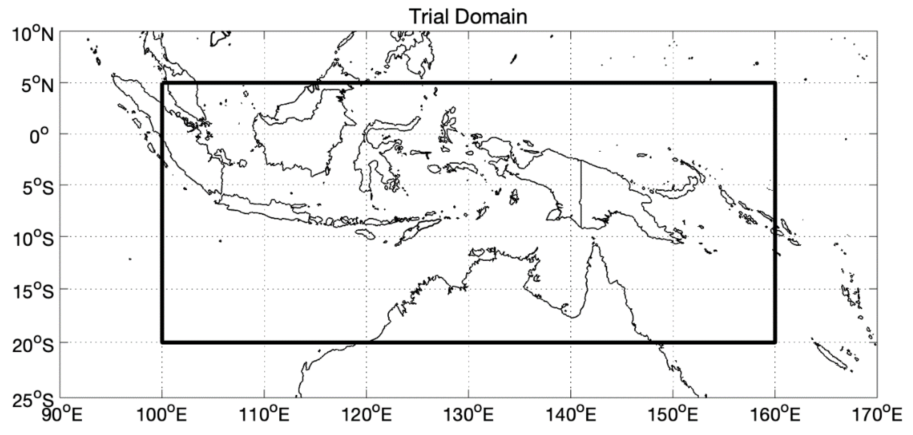
The area of coverage for the HIWC product is 5° N–20° S, 100–160° E, with a horizontal resolution of 0.02 degrees, and from FL200 to FL450 at 14 levels (
Figure 2). It is updated every 10 min immediately following receipt of the H8 satellite data and associated processing. There is a latency of approximately 25 min from the satellite scan start time until the product is available for users. This is due to the time required for completion of the full satellite scan from north to south, receipt and pre-processing of these data in the Bureau (around 16 min), plus processing by ALPHA and dissemination of the product (9 min). It is noted that the full H8 scan takes nearly 10 min to complete from north to south, and the local scan time at the equator is around 5 min later than the nominal scan start time. Hence, for areas near the equator, the latency in receipt of the HIWC product is, in fact, around 20 min after the scan time across that area.
To facilitate secure and efficient collaboration between the Bureau and NCAR, ALPHA was installed on an Amazon Web Services (AWS) Elastic Cloud Compute (EC2) platform, configured as a virtual private cloud. This provided a secure environment that was accessible by both Bureau and NCAR scientists, enabled the installation, configuration, and maintenance of ALPHA, uploading of input data, processing of these data by the application, downloading of output products for dissemination to user groups, and archiving of the output.
Planning meetings were held with airline representatives, including pilots, flight operations personnel, and the airline weather forecasting personnel. It was agreed that the HIWC product should be made available to the meteorologists in the airline flight operations area. Arrangements were made to deliver the HIWC product to user systems as a netCDF file that was automatically ingested and made available as an overlay with other products, such as infrared satellite imagery on operational workstations. This is illustrated in
Figure 3. For the display systems, an RGBA color map for the product was developed to highlight increasing values of the HIWC Potential. Values of HIWC Potential less than 0.2 are not considered significant, and the alpha (A) value in the color map was set to zero, or transparent, so they were not displayed. Education material was prepared, and training sessions were held for personnel.
6. Discussion
In this paper, the reliable provision of a near-real-time, automated, and frequently updated HIWC product to stakeholders was demonstrated through a trial conducted in the period from 1 October 2019 to 31 March 2020. The trial was a collaboration between the Bureau, NCAR, FAA, and Australian-based airlines. The area of coverage extended across Indonesia, PNG, and northern Australia, a region with frequent deep convection and a relatively high incidence of ICI events. For this trial, the “two-input” version of ALPHA, based on satellite and NWP data only, was used. Apart from upper and lower bounds, this provides no information on the vertical structure of the HIWC Potential.
ALPHA was adapted to ingest data from the Bureau’s ACCESS model and the Japan Meteorological Agency Himawari-8 satellite. The output HIWC product was updated every 10 min following receipt and pre-processing of the satellite data and processing by ALPHA. There was a latency of approximately 25 min from the satellite scan start time until the product was available to users. In practice, the satellite scans across the trial domain around 5 min after the start time, so the latency is around 20 min.
The HIWC product was disseminated to stakeholders as a netCDF file and processed to enable overlay on other products, such as infrared satellite imagery and lightning data, in operational workstations. For display systems, an RGBA color map was developed to highlight increasing values of HIWC Potential. A period of intensive operations was conducted from 1 October 2019 to 31 March 2020.
To validate the HIWC product, we compared it with IWC profiles retrieved from CloudSat data, aligning the vertical cross section of IWC with the ALPHA data in location and time. Data from 397 ascending daytime passes across the domain in the operational period were used. Quantitative validation of the night-time HIWC product was not possible, as night-time radar data is not available from CloudSat following a battery failure in 2011. The CloudSat radar has a small footprint and care is required to ensure correct alignment with the H8 satellite data and HIWC Potential field, particularly near the edges of cloud features where gradients can be high, to account for time differences between scans, parallax errors, and navigation errors.
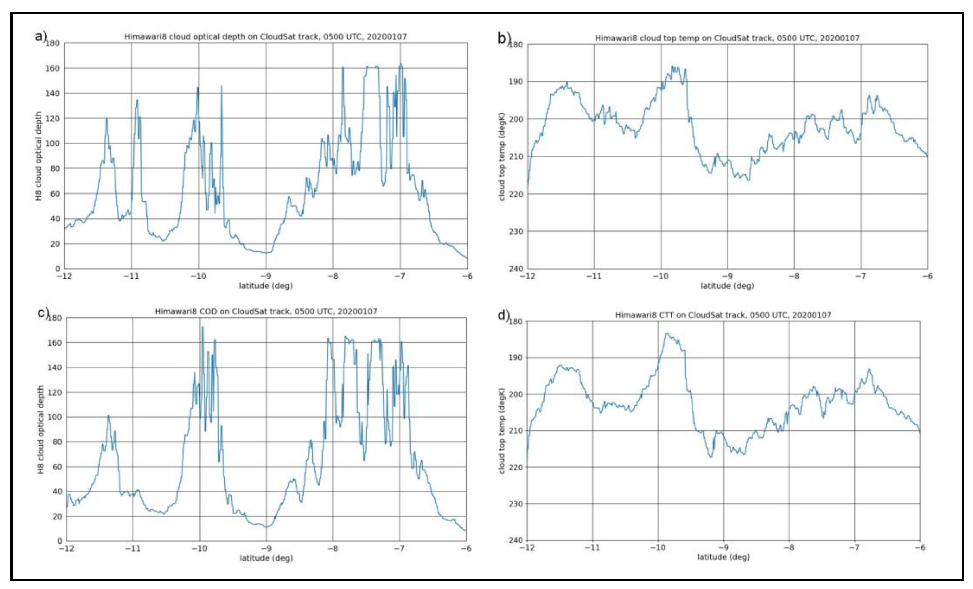
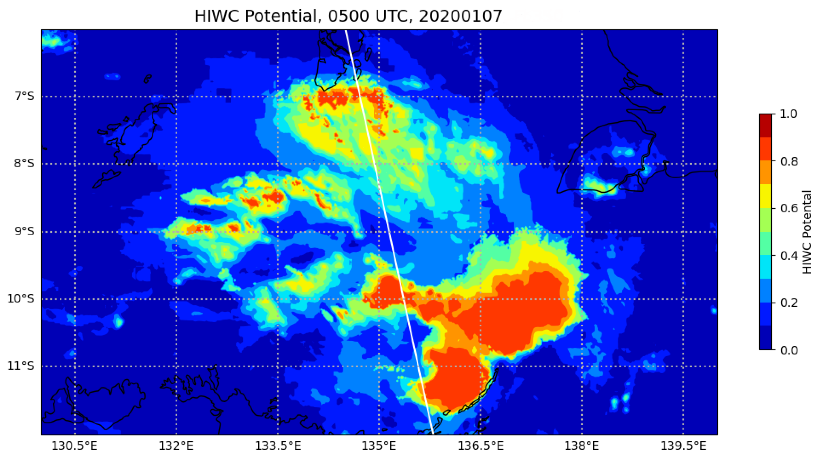
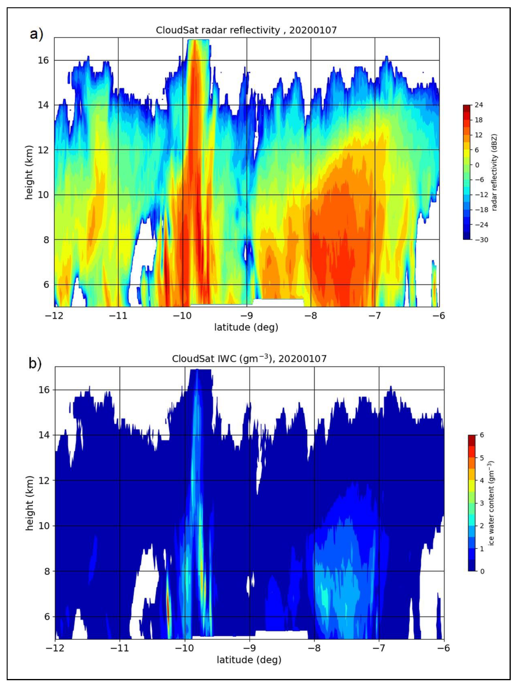
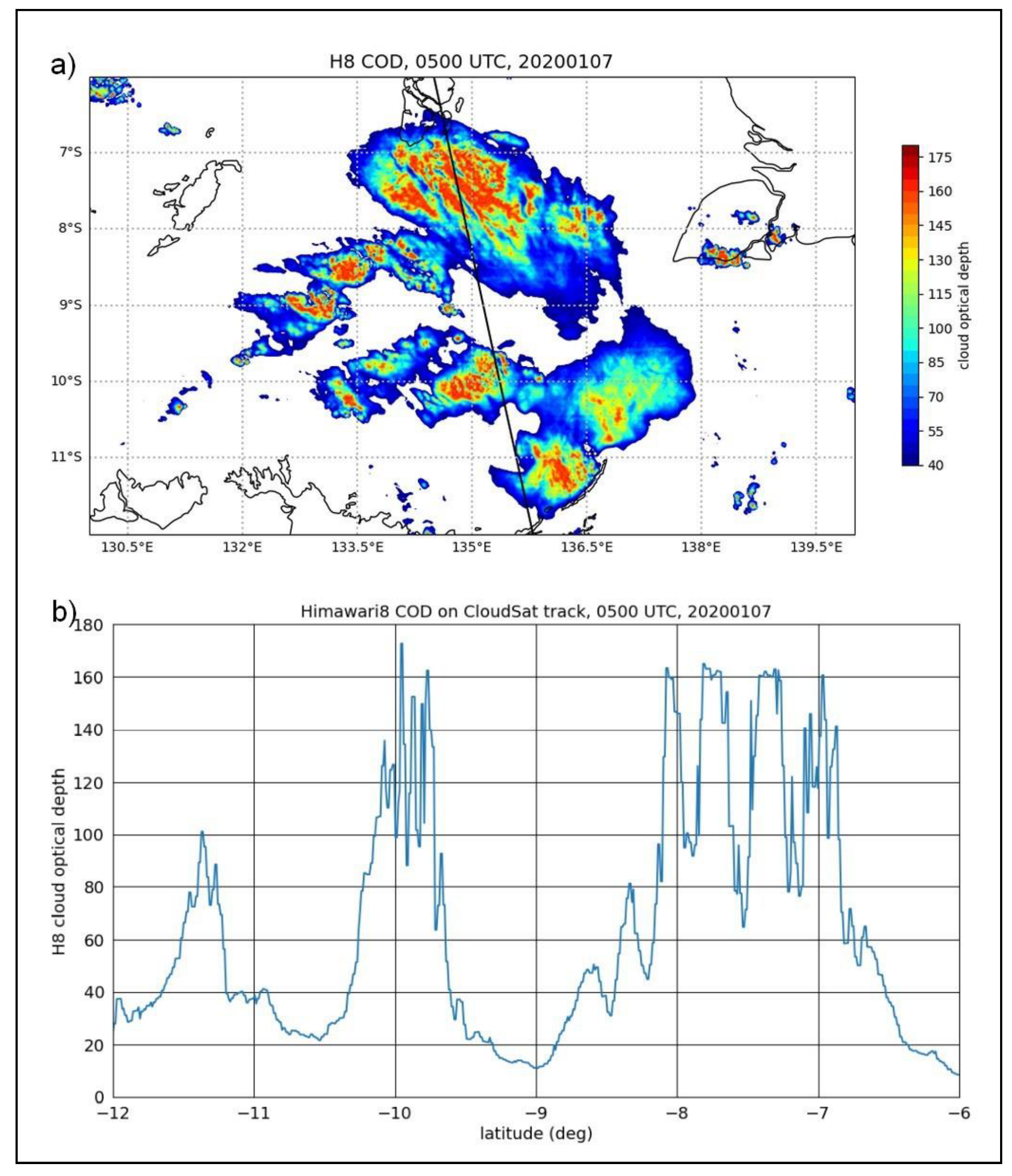
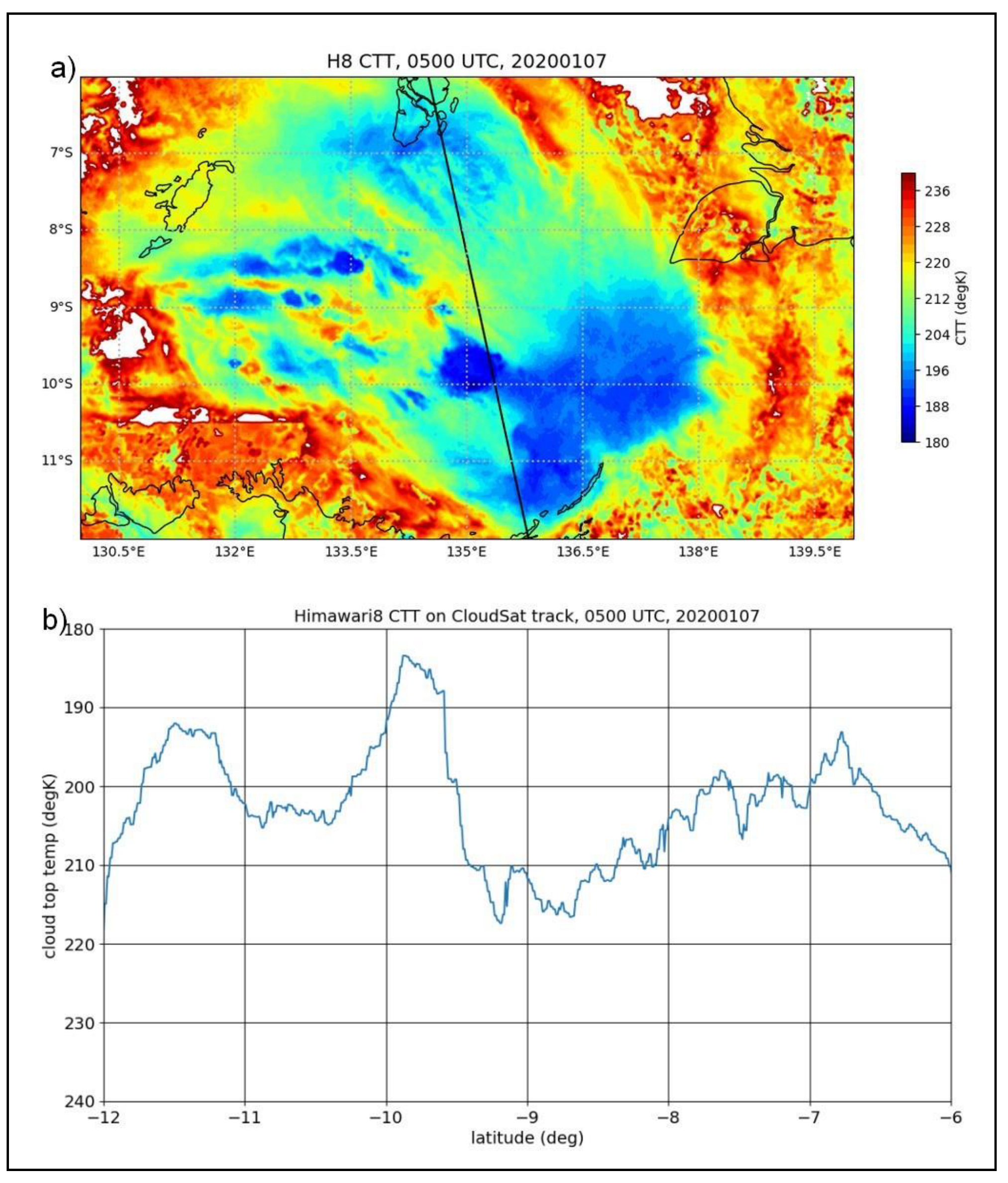
A case study from 0500 UTC, 7 January 2020, presents a detailed comparison of the HIWC Potential field with the CloudSat vertical cross section of IWC for a mesoscale convective system centred around 9° S, 135° E, north of the Northern Territory, Australia. The CloudSat radar intersected three areas where the ALPHA product indicated elevated HIWC Potential. These areas were centred around 11.3° S, 10.0° S, and 7.5° S. The vertical cross section of radar reflectivity from CloudSat shows that these three areas have elevated radar reflectivity and IWC with differences in the horizontal and vertical structure for each.
Comparison of the column maximum IWC from CloudSat with the corresponding HIWC Potential from ALPHA shows that high values of the potential correlate well with ice water concentrations of 2 g m−3 and higher for the areas around 10° S and 7.5° S. The satellite data also showed high values for the COD and cold temperatures (CTT and BT10) in these areas, consistent with higher IWCs.
For the area around 11.3° S, the HIWC Potential is comparable with the areas at 10° S and 7.5° S, but the CloudSat data shows the column maximum IWC was only in the range 0.5–1.0 g m−3. This exceeds the 0.5 g m−3 IWC threshold used in the development of ALPHA but is not consistent with higher values of HIWC Potential, indicating higher values for column maximum IWC. For this area the CloudSat satellite intersected the edge of the cloud feature, and although the COD is significantly lower on this flight segment, the CTT and BT10 are very cold. It is the blend of these fields that determines the areal extent of the high HIWC Potential. It is almost certain that the maximum IWC would be higher a short distance east of the CloudSat track where the COD is higher and there are colder cloud top temperatures. The fuzzy logic membership functions for the CTT and BT10 have sharp changes at the inflection points, and if the temperature is colder than these thresholds the HIWC Potential increases sharply. A more gradual change in the membership function across the inflection points should be investigated.
Although there was no CloudSat radar data for the night-time descending pass, subjective monitoring of the HIWC product showed that coherent structures were maintained across the day-night transition periods, albeit with some changes in the HIWC Potential. This also showed that convection can be quite dynamic but that local areas of elevated HIWC can persist for many hours.
As discussed by H2020, there are some limitations with ALPHA. The satellite retrievals largely represent conditions near the cloud top, the NWP model data currently does not have the spatial resolution or required skill to capture convective processes adequately, and radar coverage can be limited. For the “two-input” version of ALPHA, information on the vertical structure of IWC is limited to the lower and upper bounds, whereas there can be significant variation as illustrated in the case study from 7 January 2020. Notwithstanding this limitation, ALPHA has widespread coverage with good spatial and temporal resolution and is available in near real-time. Conduct of the ALPHA trial and validation of the HIWC product against CloudSat data provides confidence in the potential utility for providing guidance on possible ICI and the path length for flight planning, maintaining situational awareness, and flight monitoring.
The project objectives relating to the evaluation of the utility of the HIWC product by users were severely impacted by the COVID-19 pandemic, as it resulted in a sudden and severe reduction in airline operations during this trial and an inability to progress this activity. However, a 2 month study was undertaken in 2022 in the USA to evaluate the utility of the HIWC product for supporting flight operations across the CONUS [
28]. The HIWC product was made available to a selected group of 17 people comprising meteorologists (airline and national weather service), flight dispatch personnel, and pilots. Participants were asked to consider the product’s utility for providing situational awareness and enabling the avoidance of HIWC conditions. The evaluation team and subject matter experts conducted interviews with each participant and asked them to complete questionnaires on the utility of the product in their decision-making during operations. Results showed that the participants found the product to be understandable and easy to use, and that they used it as supplementary information to other products that are used routinely. It also became apparent that there was limited understanding of the frequency and impact of ICI events among the group, and the absence of a formal requirement for HIWC guidance diminished the perceived need for an operational nowcasting product. Education is required to ensure a better understanding of the impact of ICI events. There is a need to consider other product formats that might be required for display in flight operations areas, on the flight deck and other potential user groups. Subject to user requirements operational procedures will also need to be developed. Good user engagement will be required to progress with these objectives.
In recent years engine manufacturers have implemented modifications in newer aircraft to mitigate the risk of ICI and to meet upgraded engine certification standards. Engine monitoring data are routinely recorded, and these should provide a valuable source of information for further validation and improvement of ICI nowcasting products. It is also noted there are currently no ICI detectors certified for commercial aircraft, and that confirmation of an ICI event, including anomalous air data probe readings, requires a detailed post-event analysis, for which resources are limited. There is a belief the true number of ICI events, including anomalous air data probe readings, is significantly higher than currently reported, and, as such, the development and certification of an ICI detector for commercial aircraft should be a priority. Establishing international arrangements whereby these data can be shared for the further development of HIWC guidance products would be of great value.
Under the ICAO Global Air Navigation Plan (GANP) there are moves towards a data-centric model for air traffic management (ATM) products, including weather data, on a range of time and space scales to support more automation. Provision of an automated near real-time, gridded HIWC product with a relatively high temporal and spatial resolution as demonstrated in this trial is consistent with this objective. This would enable the provision of a guidance product to flight operations groups, as well as to the flight deck.

