Article

Impact of Assimilating Conventional Observations on Short-Term Nearshore Wind Forecast over the East China Sea

1
Key Laboratory of Far-Shore Wind Power Technology of Zhejiang Province, Hangzhou 311122, China
2
School of Meteorological Observation, Chengdu University of Information Technology, Chengdu 610225, China
3
Power China Huadong Engineering Corporation Limited, Hangzhou 311122, China
*
Author to whom correspondence should be addressed.
Atmosphere 2023, 14(1), 47; https://doi.org/10.3390/atmos14010047
Submission received: 26 October 2022 / Revised: 15 December 2022 / Accepted: 23 December 2022 / Published: 27 December 2022
(This article belongs to the Section Atmospheric Techniques, Instruments, and Modeling)

Abstract

:
This study investigates the impact of assimilating conventional weather observations on the wind forecast over the nearshore region of the East China Sea. Multi-level wind measurements in the boundary layer from five masts near the coast were used to verify the numerical model forecasts. Four numerical experiments with a rapid update cycle were performed to forecast the wind field over the masts. The observation shows that the characteristics of the wind field are distinct between the onshore and offshore masts. The numerical forecasts were able to reproduce the main features of the observed wind field both onshore and offshore. However, the wind forecasts of the offshore masts showed larger BIAS and MAE than those onshore. The forecast skill was shown to be sensitive to different weather events and the choice of control variables in the assimilation. The use of new momentum control variables allows a smaller observation-minus-analysis field compared with the traditional control variables, and the resultant wind forecast showed significant improvements. Further tuning of the new control variable scheme showed little improvement of the wind forecast which demonstrates the importance of maintaining the balance between large-scale and small-scale fields in the analysis. The larger forecast error at the offshore masts was likely due to the distribution of conventional observations and the uncertainties in representing the marine boundary layer in numerical models.

1. Introduction

Electricity plays a crucial role in human life. As the country with the highest population in the world, China has seen a rapidly increasing electricity demand in recent years [1]. To meet the growing energy consumption and reduce the air pollution and climate impact related to traditional power sources, the transition to renewable energy sources has become the national policy of China [2]. Since China has a long coastline along its east and southeast border, there is a great opportunity to utilize the abundant wind energy over the nearshore region.
However, wind energy is intermittent in nature, and accurate wind power forecasts of various lead times are crucial to reduce its impact on the power grid. Longer lead times (three days and beyond) are essential for large-scale planning, and day-ahead forecasts are important for electricity trading [3]. Forecasts of lead time within a day are crucial for mechanical reliability monitoring [4]. Due to the multi-scale nature of the atmosphere flow, the accuracy of wind forecast at different lead times is subject to different physical and dynamical processes [5]. Consequently, various methods, e.g., physical, statistical, and hybrid, are used in different situations. Statistical models include simple ones such as the persistence method [6] and more sophisticated ones such as artificial neural networks (ANNs) [7] or Markov chains [8]. Pure statistical models rapidly lose their accuracy because of their inability to represent the complex evolution of weather systems and the associated physical and dynamical processes. Physical methods such as numerical weather prediction (NWP) models are based on the principles of physics, and can directly simulate the physical weather processes that generate wind [9]. Hybrid methods [7] essentially apply statistical models to the NWP outputs, aiming to combine the advantages of both statistical and physical methods. Consequently, the accuracy of hybrid models is partly determined by that of physical models.
NWP models have been widely used to forecast wind in different locations and time scales [10,11,12]. The accuracy of NWP depends on various factors [11,12,13] such as the initial condition, model dynamics and physics, etc. These factors are subjected to great uncertainties and are an area of active research. The forecast of the nearshore wind field is particularly challenging due to the fact that the atmosphere circulation is controlled by complex mesoscale land–sea interactions. The wind onshore is mainly determined by the physical and thermal structures of land, whereas the wind off shore is largely controlled by the synoptic weather and the surface conditions at the upwind coast [14]. The land-sea temperature gradients near the coastal zone strongly affect the atmosphere stability over the sea surface by warm- and cold-air advection [15]. Thus, atmospheric models used for offshore wind predicting need to be able to accurately portray these conditions.
In order to produce reliable forecasts, the initial condition of an NWP model must be as accurate as possible. Data assimilation (DA) is devoted to producing analyses by combining an NWP model with observations so as to match the true state of the atmosphere as closely as possible [16]. The resultant analysis contains information from both the NWP model and observations, and serves as a better set of initial conditions. This study evaluated the impact of assimilating conventional observations on short-term forecast of the wind field over the nearshore region of the East China Sea. A rapid-update-cycle data assimilation and forecast system was designed to meet the requirements in a real-time wind power forecast application. The verification showed that the DA experiments were able to improve the wind field forecast especially for the frequency of intermediate winds (4~8 m s−1). The improvements were attributed to a closer fit of momentum variables to the conventional observations in the DA analyses. However, the improvement of wind forecast on the offshore sites was less significant than that on shore and varied for different weather events, which is likely related to the observation gap between land/sea [17] and the uncertainty of model physics in the marine boundary layer. The rest of this paper is organized as follows. Section 2 details the data and methodology used in this study. Statistical characteristics of the observed nearshore wind field are shown in Section 3. Section 4 verifies the short-term wind forecast of different numerical experiments and analyzes the results of DA experiments. Conclusions and discussions are given in Section 5.

2. Methodology

2.1. The Numerical Model

The numerical system used in this study consisted of the Advanced Research version of the Weather Research and Forecasting Model [18] and its variational DA system (WRFDA 3DVAR v3.9, [19]). All numerical experiments conducted in this study employed a one-way, two-domain nested grid as shown in Figure 1. The outer domain has 220 × 200 grid cells with a 15 km grid spacing and the inner domain has 346 × 316 grids with a 3 km grid spacing in the horizontal direction. Both domains have 48 terrain-following levels in the vertical direction, with increased resolution close to the surface (12 levels below 150 m) to capture the boundary layer processes. Other model options include the Kain–Fritsch cumulus parameterization scheme [20] in the outer domain, the WRF single-moment 6-class microphysics scheme [21], the Mellor–Yamada–Janjic (MYJ) planetary boundary layer (PBL) scheme [22], the Noah land surface model [23], and the RRTMG radiation scheme [24]. Details of the above schemes and other available options can be found in the WRF technical report [18]. Despite the domain of interest being near the ocean, no sea-surface temperature (SST) update was applied in the system due to the short forecast time [25,26]. This study focuses on the accuracy of wind forecast in the PBL, so the results are likely sensitive to the formulation and implementation of PBL parameterizations in the WRF model. However, as shown by previous studies [12,14,27], the performance of different PBL parameterizations strongly depends on the atmospheric stability. The MYJ scheme was used because it showed better performance in stable conditions which is common in the month of simulation (March).
This version of WRFDA includes the horizontal winds u, v as the momentum control variables, which allows a closer fit to dense observations such as automatic weather station and weather radar [28]. Conventional observations, which include surface synoptic observations (SYNOPs) and soundings (the blue and purple dots in Figure 1) from China Meteorological Administration (CMA) were assimilated in this study. The wind observations from the masts were not assimilated and only used for forecast verification. The convectional observations were unevenly distributed with most observations over land. The numerical model is intended to advect information from regions with dense observations to downstream regions without observation [29]. The conventional observations were first converted to the standard LITTLE-R format [18], and then processed by the OBSPROC program included in the WRFDA distribution. The default observation errors from the OBSPROC program were used for each control variable. The background error statistics (BES) were calculated using the National Meteorological Center (NMC) method [30] and hindcasts of the same month as the experimental period.
A schematic diagram of the assimilation and forecast cycle is shown in Figure 2. The cycle is initialized by the GFS (the Global Forecast System) forecast (https://nomads.ncep.noaa.gov, accessed on 1 July 2021) and updates every 3 h with the WRF forecast as background. At each update cycle, conventional weather observations are assimilated with the BES obtained by the NMC method. To allow large-scale and small-scale information to be treated separately and optimally [31,32], different control variable schemes and variance- and length-scale parameters were used in the outer and inner domains, respectively.

2.2. Experimental Setup and Verification

One assimilation and forecast cycle was performed each day during the entire period (31 days) of March 2015 over the east coast of China. In each forecast, a three-hourly cycle was first initialized at 12 UTC (20 LTC) on the previous day and continuously cycled until 00 UTC (08 LTC). A 72 h forecast was then conducted at 00 UTC using the analysis fields after four consecutive cycles. The initial time and forecast length were determined by the operational requirements of the power grid of China. A cold start experiment (CTRL) initialized directly by the GFS forecast at 00 UTC each day was included as a benchmark. The three DA experiments applied the same cycle strategy outlined above. They used the same GFS forecast as the initial fields and assimilated the same observations, and only differed in the choice of control variables and the tuning of the BES parameters (see detailed information in Table 1). The PSIXI experiment used stream function (ψ), unbalanced velocity potential (χ), unbalanced surface pressure, unbalanced temperature, and pseudo-relative humidity as control variables. The UV and UVs experiments used the horizontal wind (u and v), surface pressure, temperature, and pseudo-relative humidity as the control variables. The PSIXI and UV experiments used the default BES from the NMC method whereas the UVs experiment was tuned to better resolve small-scale information.
The ultimate goal of this study is to improve short-term wind forecast in the nearshore region. Therefore, the performance of different experiments was evaluated by the skill of the low-level wind forecast in addition to some diagnoses on the 3DVAR analysis fields. The wind measurements from five masts near the east coast of China (the red crosses in Figure 1) were used for verification. Three (two) of the five masts were onshore (offshore). Multiple cup anemometers were mounted at several heights (30, 50, 70, 90, and 100 m) for continuous measurement at 1 Hz, and the 10 min averaged wind was used for comparison with the model forecasts. The skill of wind forecasts is measured by the mean absolute error (MAE), bias (BIAS), and mean absolute percent error (MAPE) as follows:
M A E = 1 n i = 1 N F i O i
B I A S = 1 n i = 1 N F i O i
M A P E = 1 n i = 1 N F i O i / O i
where Fi and Oi are the forecasted and observed wind speed of the ith forecast and N is the total number of forecasts in the verification domain.

3. Characteristics of Nearshore Wind Field

The wind field distributions in the nearshore region are highly related to the varying atmospheric and surface conditions. Figure 3 shows the diurnal cycle of the observed wind speed at the onshore and offshore masts. The onshore masts (Figure 3a) display a diurnal cycle modulated by the evolution of planetary boundary layer. The wind speed at the upper level (90 m) is generally stronger before midnight (the nocturnal jet) and weaker before noon. The wind at the lower level (50 m) is stronger in the afternoon and weaker in the morning. The difference in wind speed between the upper and lower levels increases during the night and decreases during the day. This is likely due to surface friction and the strength of turbulence mixing. The strong surface friction significantly reduces the wind speed at the lower level (50 m), and the prevalence of turbulence mixing acts to accelerate (deaccelerate) the lower (upper) level of wind speed during the day. Despite the offshore masts being spatially close to the onshore masts, the variation in wind speed is clearly different. The wind speed at the two levels shows similar diurnal variation to that of the onshore masts but is stronger due to the reduced surface friction. The evolution of the planetary boundary layer shows similar impacts on the upper and lower levels. Since the variations of wind speed are similar within each panel of Figure 3, the following paragraphs will only show results of one onshore (#1) and one offshore (#4) mast.
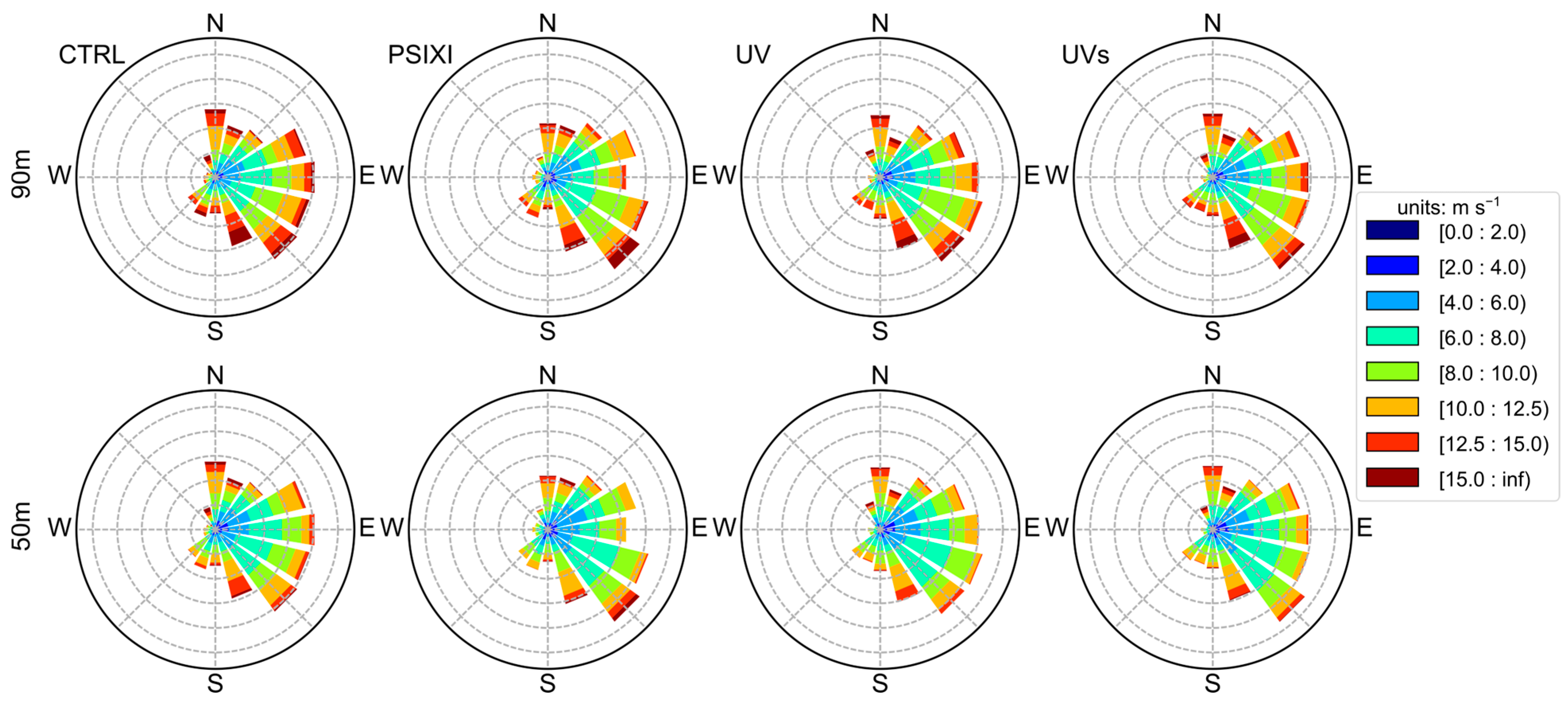
Figure 4 shows the wind roses of the onshore and offshore masts at 50 m and 90 m, respectively. The onshore (offshore) mast mainly shows east to south (east to north) winds. Despite there being a higher frequency of intermediate-to-weak winds in the southeast direction for the onshore mast, the stronger winds are mainly from the northeast direction for both the onshore and offshore masts. The frequent strong winds in the northeast direction are likely related to the sea breeze circulation [33] considering the similar orientation of coastline at the two masts (Figure 1). The results in Figure 3 and Figure 4 indicate that the wind distribution could vary greatly over a short distance in the nearshore region. The distinct characteristics of observed wind distribution at adjacent onshore and offshore masts pose greater challenges for numerical models to accurately capture these small-scale variations.

4. Forecast Verification

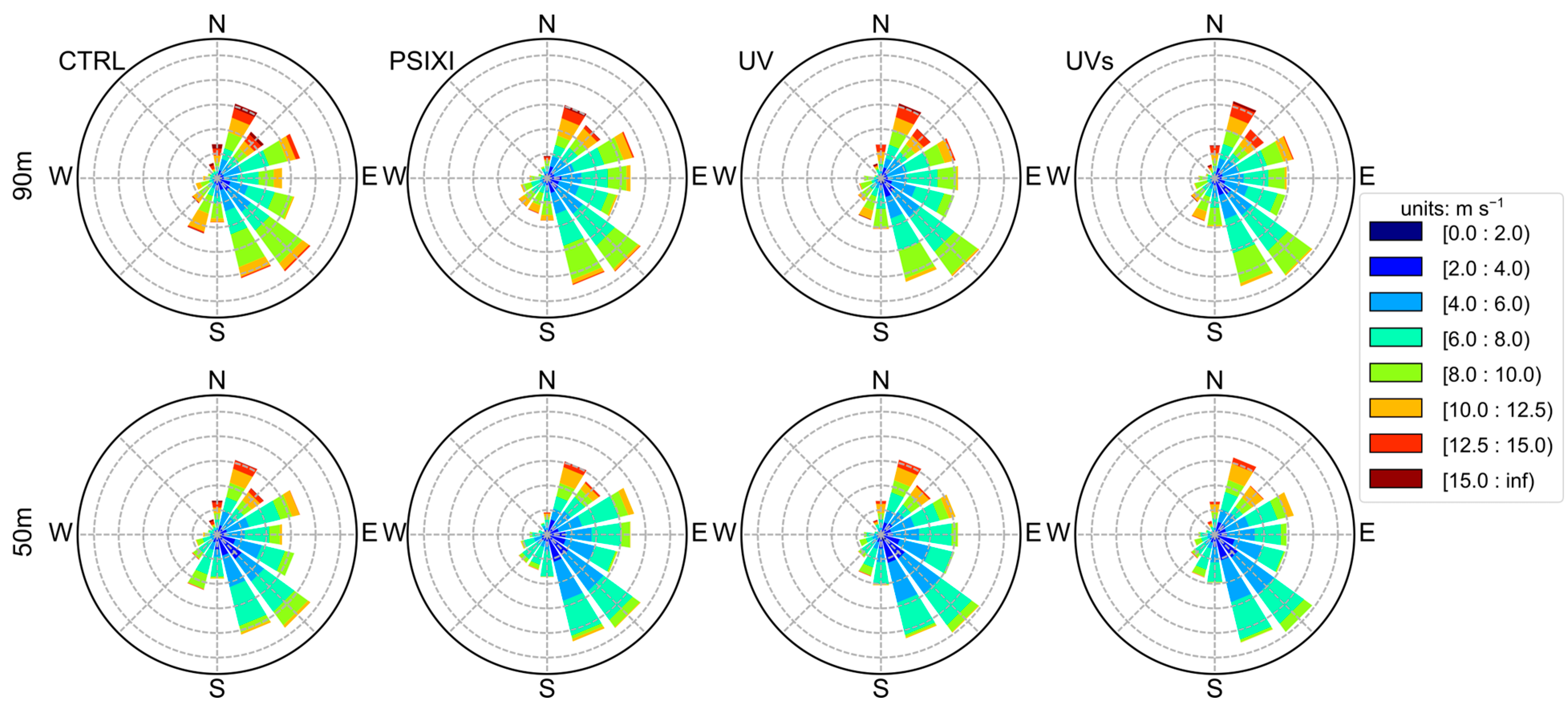
Figure 5 shows the forecasted wind roses of different numerical experiments over the onshore mast. The forecasted distribution of wind direction captured the higher frequency of the easterly wind but showed lower frequency of the south and southwest winds. The forecasted wind direction at the two levels from different experiments showed little difference compared with the observation. The similarity between different experiments demonstrates the inability of the numerical model to simulate fine-scale vertical variations of the real wind field. The forecasted wind speed accurately reproduced the strong winds in the northeast direction. The forecasted frequencies of winds stronger than 10 m s−1 were similar between different experiments, but different for winds weaker than 8 m s−1. The forecasts of the DA experiments were more consistent with the observation with a higher frequency of wind speed between 4~6 m s−1 at 50 m and 6~8 m s−1 at 90 m.
Figure 6 shows the forecasted wind roses of different experiments over the offshore mast. The wind direction and speed forecasts of the offshore mast were similar in different experiments, but inferior to those of the onshore mast compared with the observation. There was an over-forecast of the east-to-southeast winds, and an under-forecast of the north-to-northeast winds. The forecasted wind speed was too strong in the east-to-south direction compared with the observation. The lower forecast skill at the offshore mast is shown more clearly in Table 2 in terms of larger BIAS, MAE, and MAPE of wind speed. It is noted that the MAPE at 50 m of the onshore mast is the largest partly due to its overall lower wind speed as shown in Figure 3a. The larger forecast error at the offshore mast is likely related to the different structure of the marine boundary layer. The existing PBL parameterization schemes in WRF are optimized for land and are not able to produce fully realistic results in the marine boundary layer [13].
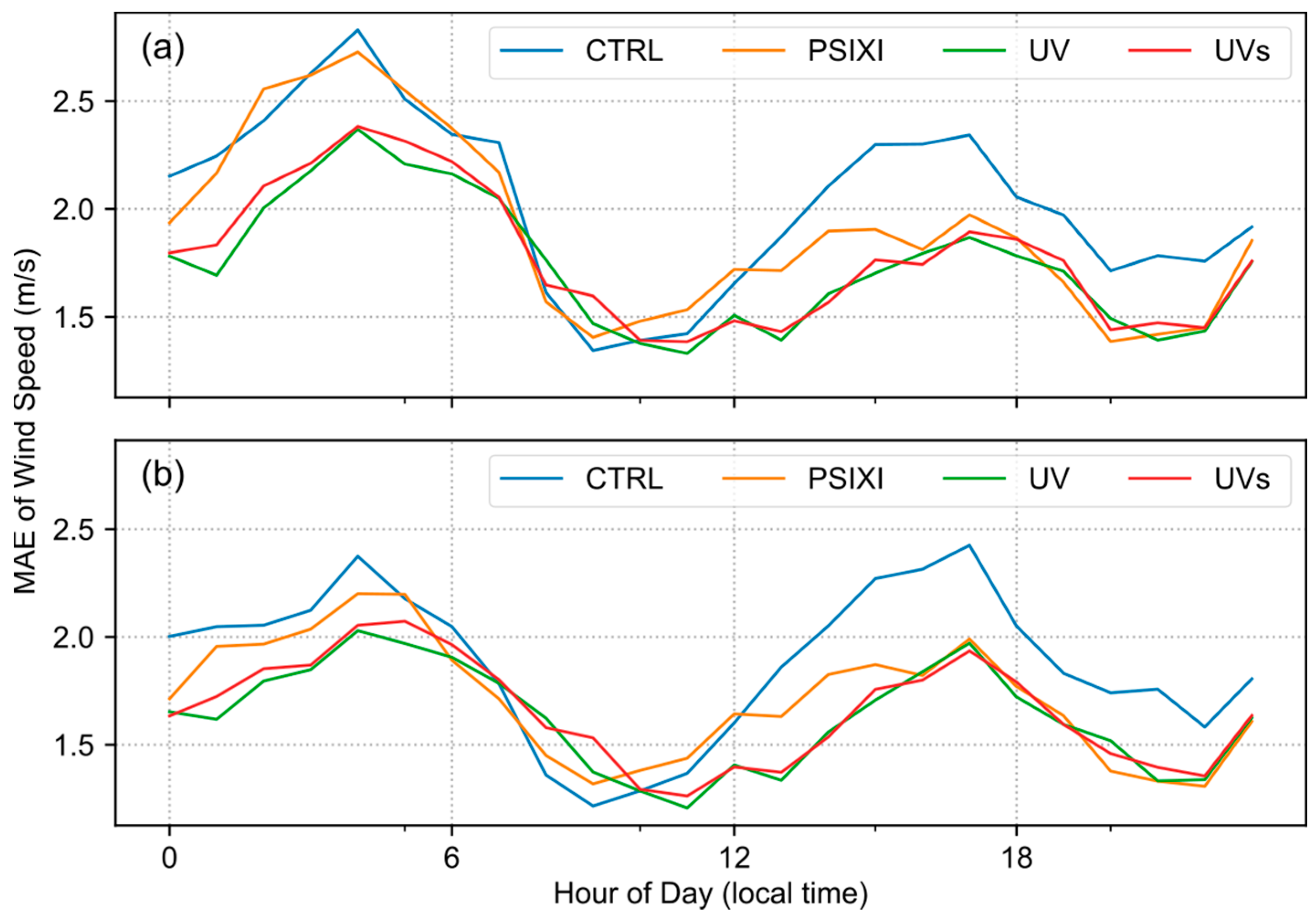
The wind roses of forecasted wind shown in Figure 5 and Figure 6 indicate that the model forecasts were statistically consistent with the observations. Figure 7 further shows the MAE of different experiments averaged by the hour of day at the onshore mast. The MAEs at 90 m are generally larger than those at 50 m, which is partly related to the stronger wind speed at 90 m. All experiments show a similar diurnal variation of MAE with larger values in the afternoon (15~18 LTC) and midnight (03~06 LTC) but smaller values before noon (08~11 LTC) and in the evening (21~23 LTC). The three DA experiments show various degree of improvements over CTRL and the improvement seems to be proportional to the MAE values of the CTRL experiment. All four experiments show comparably low MAEs during 06~12 LTC and the greatest improvement in the afternoon.
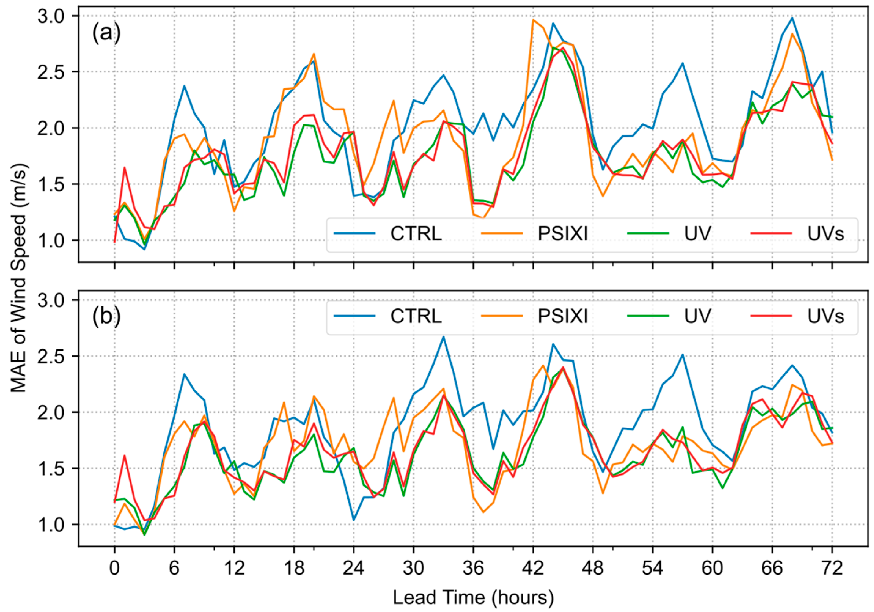
Figure 8 shows the MAE of different experiments averaged by lead times at the onshore mast. The MAEs of forecasted wind speed increase gradually with lead time and the DA experiments generally show smaller MAEs than the CTRL. The MAEs show a similar diurnal pattern with higher values in the morning and evening as depicted in Figure 7. The similar variation of MAE at different lead times is partly related to the fact that these experiments were initialized at the same hour every day. Due to the limited forecast samples, the improvement of the DA experiments seems to be not systematic and is most significant when the MAE of the CTRL is large.
Figure 9 shows the MAE of different experiments averaged by the hour of day at the offshore mast. The MAEs of wind speed forecast show distinct characteristics compared with those of the onshore mast. There is a peak near 06 LTC and two minimum values in the midnight and before noon. All experiments show a weak diurnal cycle and the DA experiments only marginally outperform the CTRL experiment during the night. There seems to be a larger difference in MAE between the three DA experiments than that at the onshore mast.
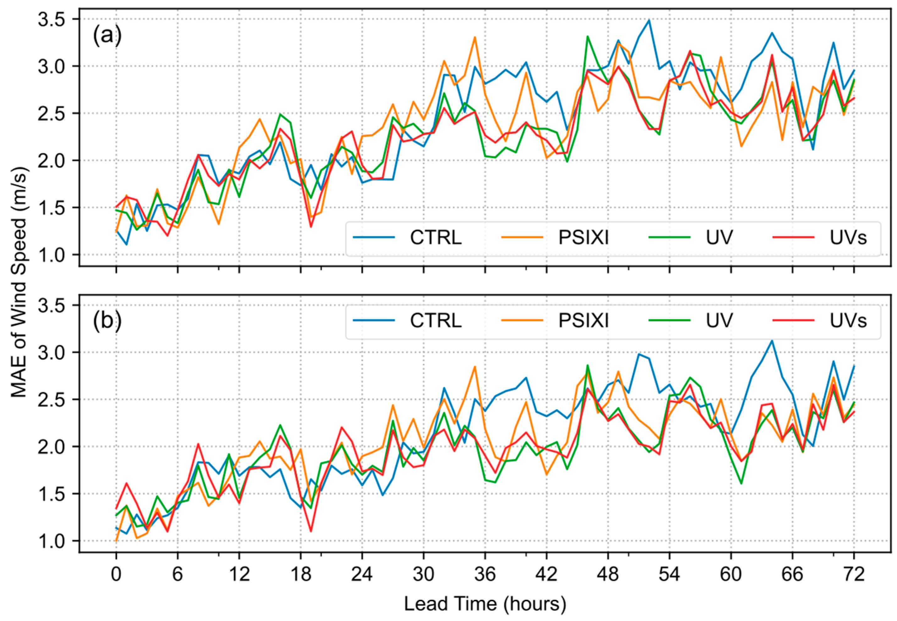
Figure 10 shows the MAE of different experiments averaged at lead times at the offshore mast. Compared with the forecasts of the onshore mast, the difference of MAE between experiments is less significant. All experiments perform similarly before 36 h and the DA experiments only show better forecasts than those of the CTRL after 36 h. The improvement of the DA experiments also seems to be more significant when the MAE of the CTRL is large.
Except for the dependency on lead time, the accuracy of wind forecasts may vary under different weather events, e.g., mesoscale-dominant and fair weather. In order to understand the source of model uncertainties across scales, the hourly forecasts were categorized into two groups by the amount of accumulated precipitation. Forecasts are deemed to be under fair weather when the hourly accumulated rainfall averaged over the inner domain (Figure 1) is less than 0.1 mm or under mesoscale-dominant weather when the hourly accumulated rainfall averaged is greater than 0.1 mm. The hourly rainfall was created by averaging the Integrated Multi-satellitE Retrievals for Global Precipitation Measurement (IMERG) Final Precipitation L3 Half Hourly V06 [34]. Figure 11 shows the diurnal cycle of wind speed forecasts at 90 m from the onshore and offshore masts, respectively. For the conciseness of the results, only the results of the CTRL and UV experiments are displayed because the UV experiment showed overall better performance. It is clear that the forecast accuracy was significantly different under the two types of weather events. The forecasts of the UV experiment had smaller MAEs under both the mesoscale-dominant and fair-weather events over land. However, the improvement of the UV experiment was less significant over ocean, especially under the mesoscale-dominant events. The better performance over land is likely related to the dense observations and more realistic representation of the PBL as will be shown in the following analysis.
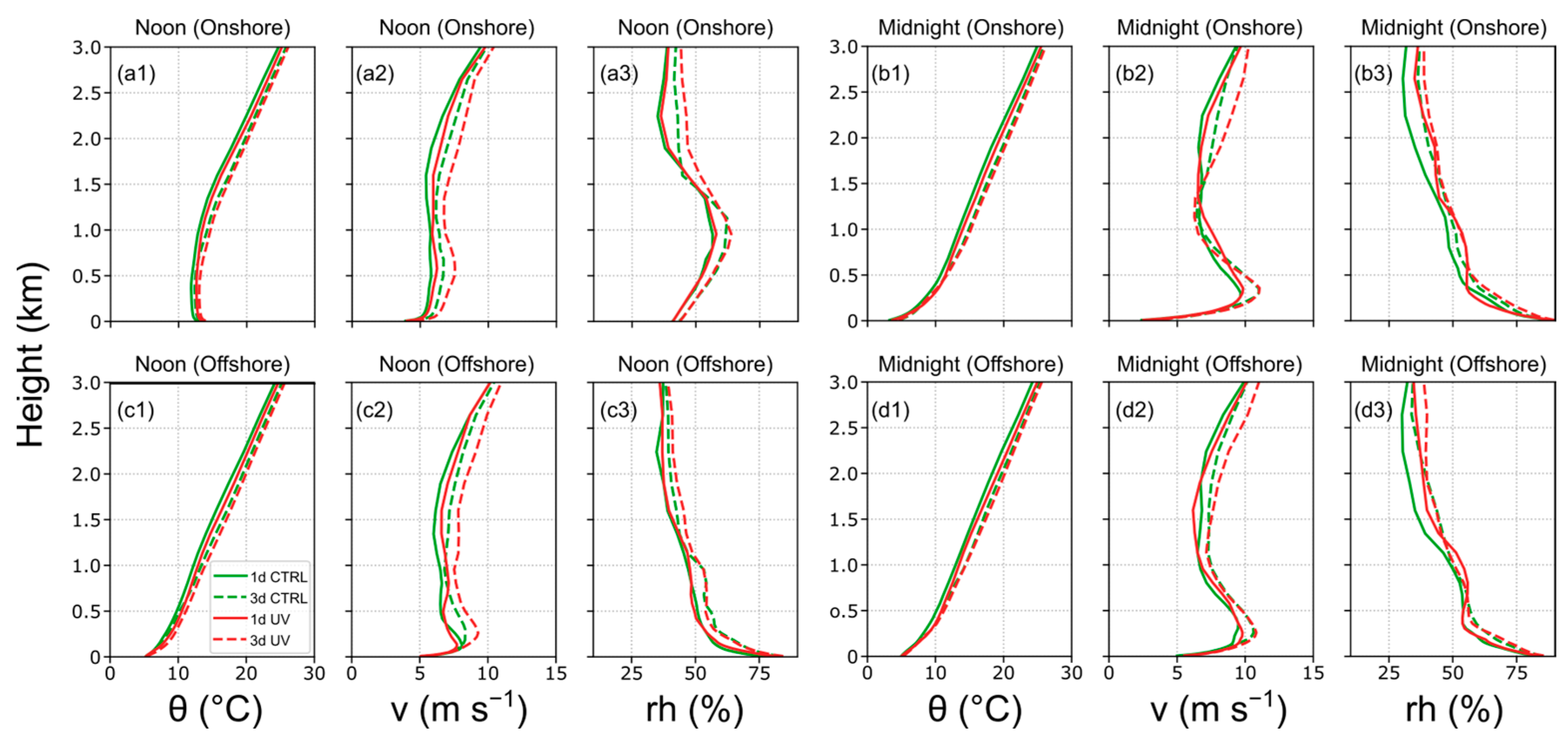
The wind forecasts of interest in this study were in the lower part of the PBL. Therefore, the forecast accuracy is subjected to the ability of the model to reproduce the structure and evolution of the PBL near the masts. Figure 12 shows the mean profile of potential temperature ( θ ), wind speed ( v ), and relative humidity ( r h ) validated at 14 (noon) and 02 LTC (midnight) over the onshore and offshore masts on the first and third forecast days. The two hours correspond to the time when the PBL is most unstable and stable during a day. Figure 12 demonstrates that the numerical experiments conducted in this study have different abilities in simulating the PBL structure. The PBL over the onshore mast shows typical and contrasting profiles between day and night, including a well-mixed layer under 500 m (Figure 12a1) and a nocturnal jet (Figure 12b2). However, the PBL profiles over the offshore mast were less different between day and night with a similar variation regardless of the time of day. The similar profiles suggest that current model configuration and dataset may not be sufficient to accurately simulate the marine PBL structure. This may contribute to the fact that the improvement of the DA experiments was less significant over the offshore masts.
The above results show that the application of DA is able to improve the short-term wind forecast over the nearshore region despite the fact that the degree of improvement may vary. To further understand the factors responsible for the different results of the DA experiments, the observation-minus-analysis (OMA) and observation-minus-background (OMB) fields of different control variables are shown in Figure 13. The OMA/OMB fields were commonly used to demonstrate the degree of contribution from the observation and model background in the analysis field [35]. A smaller OMA means that the analysis field is close to the observation. The linear regression equations in the upper-left corner of each panel show that the values of OMA are generally smaller than those of the OMB for all control variables, which indicates that the use of DA is effective in bringing the initial field closer to the observation. Due to the different parameters, the slope of the regression line varies in different DA experiments. Since the main difference between the PSIXI and UV (UVs) experiment is the choice of momentum control variables, the difference of horizontal winds (U and V) is much greater than that of pressure (P), temperature (T), and specific humidity (Q). The use of the UV scheme also seems to impact other variables such as P. Despite the smaller OMA of U, V in the UVs experiment compared with those of the UV experiment, the MAE of forecasted wind speed does not benefit from the closer fitting to the observation. This demonstrates that a good analysis field has to balance the information from both the observation and the model background.

5. Conclusions and Discussion

This study investigates the impact of assimilating conventional weather observations on the wind forecast over the nearshore region of the East China Sea. Three onshore and two offshore masts with wind measurements at different heights in the planetary boundary layer were used to verify the performance of four numerical experiments with or without data assimilation. Despite the spatial proximity of the five masts, the onshore masts show different characteristics of the wind field from the adjacent offshore masts. The wind fields of the onshore masts were significantly modified by the turbulence mixing associated with the diurnal cycle. The upper-level (90 m) wind speed is significantly decreased whereas the lower-level (50 m) wind speed is increased during the day when the planetary boundary layer is well mixed. On the other hand, the offshore wind speed is stronger due to the reduced surface friction. The turbulence mixing acts to reduce the wind speed at both the 50 and 90 m levels.
The forecasted wind fields of different numerical experiments generally reproduced the distribution of the observed wind. The forecast accuracy is closely related to the forecast lead time, the type of weather events, and the ability to reproduce realistic PBL structures. The forecasts of the onshore masts were generally superior to those of the offshore masts. The forecasted wind fields of the offshore masts suffered from overprediction of stronger winds in the east-to-southeast direction. The DA experiments show various degrees of improvements over the CTRL experiment. The main improvement manifests in a closer frequency of intermediate winds (4~8 m s−1) compared with the observation. The UV experiment generally shows better wind forecasts because of a closer fit of the analysis field to the observations, especially the momentum variables. However, further tuning for small-scale information by the UVs experiment did not lead to better forecasts, which indicates that the balance between large-scale and small-scale information is equally important in assimilating high-resolution observations.
This preliminary study shows that the application of data assimilation is able to improve the short-term wind prediction over the nearshore region of the East China Sea. This improvement is crucial for better integration of wind energy into the power grid and further reducing the consumption of traditional energy sources. However, the improvements in wind forecast are less significant over the ocean than on the land. The inferior forecasts over the ocean are likely related to the distribution of observation and the representation of the marine boundary layer processes. Available observations covering the entire boundary layer are still scarce. The wind distribution in the boundary layer is largely determined by the PBL scheme of numerical models, which is subjected to great uncertainties. Since there are many wind turbines located offshore in the East China Sea, further research is required to understand how to better represent the atmosphere physics cross the boundary of land and sea.

Author Contributions

Conceptualization, X.T.; Data curation, X.D.; Funding acquisition, S.Z.; Project administration, Y.L. and X.C.; Writing—Original draft, X.D. and X.T.; Writing—Review & editing, J.T. and X.T. All authors have read and agreed to the published version of the manuscript.

Funding

This research was funded by the National Natural Science Foundation of China (Grant No. 41505045).

Institutional Review Board Statement

Not applicable.

Informed Consent Statement

Not applicable.

Data Availability Statement

The GFS data can be freely obtained online (http://nomads.ncep.noaa.gov, accessed on 26 October 2022). The surface observations can be downloaded from Zenodo (DOI: 10.5281/zenodo.5853083). The WRF and WRFDA codes used in this study are provided by the NCAR MMM website (http://www2.mmm.ucar.edu/wrf/users/download/get_sources.html, accessed on 26 October 2022).

Conflicts of Interest

The authors declare no conflict of interest.

References

  1. Adams, F.G.; Shachmurove, Y. Modeling and forecasting energy consumption in China: Implications for Chinese energy demand and imports in 2020. Energy Econ. 2008, 30, 1263–1278. [Google Scholar] [CrossRef]
  2. Fan, Y.; Xia, Y. Exploring energy consumption and demand in China. Energy 2012, 40, 23–30. [Google Scholar] [CrossRef]
  3. Kritharas, P.P.; Watson, S.J. A Comparison of Long-Term Wind Speed Forecasting Models. J. Sol. Energy Eng. Trans. ASME 2010, 132, 041008. [Google Scholar] [CrossRef]
  4. Alessandrini, S.; Sperati, S.; Pinson, P. A comparison between the ECMWF and COSMO Ensemble Prediction Systems applied to short-term wind power forecasting on real data. Appl. Energy 2013, 107, 271–280. [Google Scholar] [CrossRef]
  5. Santhosh, M.; Venkaiah, C.; Kumar, D.M.V. Current advances and approaches in wind speed and wind power forecasting for improved renewable energy integration: A review. Eng. Rep. 2020, 2, 1–20. [Google Scholar] [CrossRef]
  6. Wu, Y.-K.; Hong, J.-S. A Literature Review of Wind Forecasting Technology in the World. In Proceedings of the 2007 IEEE Lausanne Power Tech, Lausanne, Switzerland, 1–5 July 2007; pp. 504–509. [Google Scholar]
  7. Hong, Y.-Y.; Rioflorido, C.L.P.P. A hybrid deep learning-based neural network for 24-h ahead wind power forecasting. Appl. Energy 2019, 250, 530–539. [Google Scholar] [CrossRef]
  8. Carpinone, A.; Giorgio, M.; Langella, R.; Testa, A. Markov chain modeling for very-short-term wind power forecasting. Electr. Power Syst. Res. 2015, 122, 152–158. [Google Scholar] [CrossRef] [Green Version]
  9. Sandeepan, B.S.; Panchang, V.G.; Nayak, S.; Kumar, K.K.; Kaihatu, J.M. Performance of the WRF Model for Surface Wind Prediction around Qatar. J. Atmospheric Ocean. Technol. 2018, 35, 575–592. [Google Scholar] [CrossRef]
  10. Zhang, H.; Pu, Z.; Zhang, X. Examination of Errors in Near-Surface Temperature and Wind from WRF Numerical Simulations in Regions of Complex Terrain. Weather. Forecast. 2013, 28, 893–914. [Google Scholar] [CrossRef] [Green Version]
  11. Fernández-González, S.; Martín, M.L.; García-Ortega, E.; Merino, A.; Lorenzana, J.; Sanchez, J.L.; Valero, F.; Rodrigo, J.S. Sensitivity Analysis of the WRF Model: Wind-Resource Assessment for Complex Terrain. J. Appl. Meteorol. Clim. 2018, 57, 733–753. [Google Scholar] [CrossRef]
  12. Siuta, D.; West, G.; Stull, R. WRF Hub-Height Wind Forecast Sensitivity to PBL Scheme, Grid Length, and Initial Condition Choice in Complex Terrain. Weather. Forecast. 2017, 32, 493–509. [Google Scholar] [CrossRef]
  13. Huang, H.-Y.; Hall, A.; Teixeira, J. Evaluation of the WRF PBL Parameterizations for Marine Boundary Layer Clouds: Cumulus and Stratocumulus. Mon. Weather Rev. 2013, 141, 2265–2271. [Google Scholar] [CrossRef] [Green Version]
  14. Svensson, N.; Arnqvist, J.; Bergström, H.; Rutgersson, A.; Sahlée, E. Measurements and Modelling of Offshore Wind Profiles in a Semi-Enclosed Sea. Atmosphere 2019, 10, 194. [Google Scholar] [CrossRef] [Green Version]
  15. Case, J.L.; Wheeler, M.M.; Manobianco, J.; Weems, J.W.; Roeder, W.P. A 7-Yr Climatological Study of Land Breezes over the Florida Spaceport. J. Appl. Meteorol. 2005, 44, 340–356. [Google Scholar] [CrossRef] [Green Version]
  16. Tang, X.; Sun, J.; Zhang, Y.; Tong, W. Constraining the Large-Scale Analysis of a Regional Rapid-Update-Cycle System for Short-Term Convective Precipitation Forecasting. J. Geophys. Res. Atmos. 2019, 124, 6949–6965. [Google Scholar] [CrossRef]
  17. Zheng, M.; Monache, L.D.; Wu, X.; Ralph, F.M.; Cornuelle, B.; Tallapragada, V.; Haase, J.S.; Wilson, A.M.; Mazloff, M.; Subramanian, A.; et al. Data Gaps within Atmospheric Rivers over the Northeastern Pacific. Bull. Am. Meteorol. Soc. 2021, 102, E492–E524. [Google Scholar] [CrossRef]
  18. Skamarock, W.C.; Klemp, J.B.; Dudhi, J.; Gill, D.O.; Barker, D.M.; Duda, M.G.; Huang, X.-Y.; Wang, W.; Powers, J.G. A Description of the Advanced Research WRF Version 3; NCAR: Boulder, CO, USA, 2008. [Google Scholar]
  19. Barker, D.M.; Huang, W.; Guo, Y.-R.; Bourgeois, A.J.; Xiao, Q.N. A Three-Dimensional Variational Data Assimilation System for MM5: Implementation and Initial Results. Mon. Weather Rev. 2004, 132, 897–914. [Google Scholar] [CrossRef]
  20. Kain, J.S.; Fritsch, J.M. Convective Parameterization for Mesoscale Models: The Kain-Fritsch Scheme. In The Representation of Cumulus Convection in Numerical Models; American Meteorological Society: Boston, MA, USA, 1993; Volume 24, pp. 165–170. ISBN 978-1-935704-13-3. [Google Scholar]
  21. Hong, S.; Lim, J. The WRF Single-Moment 6-Class Microphysics Scheme (WSM6). J. Korean Meteorol. Soc. 2006, 42, 129–151. [Google Scholar]
  22. Janjic, Z. Nonsingular Implementation of the Mellor-Yamada Level 2.5 Scheme in the NCEP Meso Model. NCEP Off. Note 2002, 437, 61. [Google Scholar]
  23. Ek, M.B.; Mitchell, K.E.; Lin, Y.; Rogers, E.; Grunmann, P.; Koren, V.; Gayno, G.; Tarpley, J.D. Implementation of Noah land surface model advances in the National Centers for Environmental Prediction operational mesoscale Eta model. J. Geophys. Res. Atmos. 2003, 108, 8851. [Google Scholar] [CrossRef]
  24. Iacono, M.J.; Delamere, J.S.; Mlawer, E.J.; Shephard, M.W.; Clough, S.A.; Collins, W.D. Radiative forcing by long-lived greenhouse gases: Calculations with the AER radiative transfer models. J. Geophys. Res. Atmos. 2008, 113, D13103. [Google Scholar] [CrossRef]
  25. O’Neill, L.W.; Chelton, D.B.; Esbensen, S.K. The Effects of SST-Induced Surface Wind Speed and Direction Gradients on Midlatitude Surface Vorticity and Divergence. J. Clim. 2010, 23, 255–281. [Google Scholar] [CrossRef]
  26. Perlin, N.; de Szoeke, S.P.; Chelton, D.B.; Samelson, R.M.; Skyllingstad, E.D.; O’Neill, L.W. Modeling the Atmospheric Boundary Layer Wind Response to Mesoscale Sea Surface Temperature Perturbations. Mon. Weather Rev. 2014, 142, 4284–4307. [Google Scholar] [CrossRef] [Green Version]
  27. Draxl, C.; Hahmann, A.N.; Peña, A.; Giebel, G. Evaluating winds and vertical wind shear from Weather Research and Forecasting model forecasts using seven planetary boundary layer schemes. Wind. Energy 2014, 17, 39–55. [Google Scholar] [CrossRef]
  28. Sun, J.; Wang, H.; Tong, W.; Zhang, Y.; Lin, C.-Y.; Xu, D. Comparison of the Impacts of Momentum Control Variables on High-Resolution Variational Data Assimilation and Precipitation Forecasting. Mon. Weather. Rev. 2016, 144, 149–169. [Google Scholar] [CrossRef]
  29. Kalnay, E. Atmospheric Modeling, Data Assimilation and Predictability; Cambridge University Press: Cambridge, UK, 2002; ISBN 0521796296. [Google Scholar]
  30. Parrish, D.F.; Derber, J.C. The National Meteorological Center’s Spectral Statistical-Interpolation Analysis System. Mon. Weather Rev. 1992, 120, 1747–1763. [Google Scholar] [CrossRef]
  31. Ha, J.-H.; Lee, D.-K. Effect of length scale tuning of background Error in WRF-3DVAR system on assimilation of high-resolution surface data for heavy rainfall simulation. Adv. Atmospheric Sci. 2012, 29, 1142–1158. [Google Scholar] [CrossRef]
  32. Tong, W.; Sun, J.; Tang, X.; Zhang, Y. Design Strategies of an Hourly Update 3DVAR Data Assimilation System for Improved Convective Forecasting. Weather. Forecast. 2016, 31, 1673–1695. [Google Scholar] [CrossRef]
  33. Huang, M.; Gao, Z.; Miao, S.; Xu, X. Characteristics of sea breezes over the Jiangsu coastal area, China. Int. J. Clim. 2016, 36, 3908–3916. [Google Scholar] [CrossRef]
  34. Zhuang, Y.; Tang, X.; Wang, Y. Impact of track forecast error on tropical cyclone quantitative precipitation forecasts over the coastal region of China. J. Hydrol. 2020, 589, 125347. [Google Scholar] [CrossRef]
  35. Dee, D.P. Bias and data assimilation. Q. J. R. Meteorol. Soc. 2005, 131, 3323–3343. [Google Scholar] [CrossRef]
Figure 1. Outer and inner model domains superposed on the terrain. The blue and purple dots represent the location of surface weather and sounding stations. The red cross shows the location of five masts for verification.
Atmosphere 14 00047 g001
Figure 2. Schematic diagram of the assimilation and forecast cycle. The red dotted box represents a complete update cycle with five DA runs (the black boxes) at a 3 h interval from 12 UTC.
Atmosphere 14 00047 g002
Figure 3. Comparison of diurnal cycle of observed wind fields at the three onshore (a) and two offshore (b) masts. Colors represent different heights, and different line styles in each panel represent different masts.
Atmosphere 14 00047 g003
Figure 4. The wind roses of observed wind fields at the onshore and offshore masts. The bars in each panel show the frequency of different wind speeds (colors) from 16 different directions (each span 22.5°).
Atmosphere 14 00047 g004
Figure 5. The forecasted wind roses from different experiments at the onshore mast.
Atmosphere 14 00047 g005
Figure 6. The forecasted wind roses from different experiments at the offshore mast.
Atmosphere 14 00047 g006
Figure 7. The diurnal cycle of the MAE of wind speed forecast at 90 m (a) and 50 m (b) from different experiments at the onshore mast.
Atmosphere 14 00047 g007
Figure 8. The variation of the MAE of wind speed forecast with lead times at 90 m (a) and 50 m (b) from different experiments at the onshore mast.
Atmosphere 14 00047 g008
Figure 9. The diurnal cycle of the MAE of wind speed forecast at 90 m (a) and 50 m (b) from different experiments at the offshore mast.
Atmosphere 14 00047 g009
Figure 10. The variation of the MAE of wind speed forecast with lead times at 90 m (a) and 50 m (b) from different experiments at the offshore mast.
Atmosphere 14 00047 g010
Figure 11. The diurnal cycle of the MAE of 90 m wind speed forecast under mesoscale-dominant (solid lines) and fair-weather (dashed lines) events at the onshore (a) and offshore (b) mast. The blue and green lines are the results of the CTRL and UV experiments, respectively.
Atmosphere 14 00047 g011
Figure 12. The comparison of the simulated PBL structure at noon and midnight of the onshore and offshore masts. The green and red lines represent the forecasts of the CTRL and UV experiments, and the solid and dashed lines represent the forecasts of the first and third days. The subfigures (a1a3), (b1b3), (c1c3) and (d1d3) show the results of potential temperature ( θ ), wind speed (v) and relative humidity (rh) at the onshore mast during noon and midnight, and at the offshore mast during the noon and midnight, respectively.
Atmosphere 14 00047 g012
Figure 13. The comparison of OMB/OMA of different control variables in the DA experiments. Different rows and columns show the results from different experiments and variables, respectively.
Atmosphere 14 00047 g013
Table 1. Configuration of numerical experiments in this study.
NameControl VariableCV OptionVariance ScaleLength Scale
CTRL////
PSIXIψχ511
UVuv711
UVsuv71.50.5
Table 2. BIAS, MAE, and MAPE of each numerical experiment at the onshore (#1) and offshore (#4) masts.
MastExpBIASMAEMAPE
50 m90 m50 m90 m50 m90 m
#1CTRL1.31.351.872.030.540.45
PSIXI0.850.851.711.910.510.44
UV0.880.881.631.740.500.41
UVs0.90.91.661.780.520.42
#4CTRL2.582.672.802.950.490.51
PSIXI1.931.992.322.500.470.49
UV2.082.142.302.460.460.48
UVs2.052.112.312.450.460.48
Disclaimer/Publisher’s Note: The statements, opinions and data contained in all publications are solely those of the individual author(s) and contributor(s) and not of MDPI and/or the editor(s). MDPI and/or the editor(s) disclaim responsibility for any injury to people or property resulting from any ideas, methods, instructions or products referred to in the content.