Abstract
Mapping the thunderstorm electrical structure could provide an effective way for lightning-sensitive facilities protection, such as aircraft and maritime assets. However, the weather radar that is normally used to forecast storms and rainfall mainly detects precipitation in the atmosphere and indicates the existence of liquid raindrops and ice particles by reflectivity. Here, we use intra-cloud events of eight thunderstorm days in the warm season, which are detected by VLF/LF Total Lightning monitoring system, to reveal the thunderstorm electrical structures in the 300 × 300 km area of the Pearl River Delta (PRD) region. The differences in height range in four types of time intervals and three types of intro-cloud events proportions are compared on 16 May. With the proportion between 20% and 80% in the time interval of 15 min, the height distribution and the electrical structure of eight thunderstorm days are clearly exhibited. The positive IC events lie in the average height between 7.5 and 12.4 km, while the negative IC events are located between 5.3 and 11.7 km. The electrical structures show the variations during the evolution process, with a dipole structure in most circumstances, while temporary reversions are identified in the initial and the dissipating stage of thunderstorms, presenting the inverted dipole and the tripole structures.
1. Introduction
The vertical distribution of thunderstorm electrical structure, which means the altitude of positive and negative charges participating in lightning, is an interesting phenomenon influenced by cloud and precipitation ice particles [1,2]. The risk of electromagnetic and lightning threats has been known and of concern in the areas of aviation, extreme weather and electric power system [3,4,5]. The basic explanations of the electrification in storm clouds are the vertical dipolar model [6], with a positive charge above a negative charge, and the tripole model [7], with a lower positive charge region below the dipole. However, with the development of measurements, more complex electrical structures have been put forward; for example, the inverted dipolar model in the southern Great Plain and Qinghai–Tibet Plateau of China [8], the inverted tripole model in northwestern Kansas [9,10] and other multi-polarity charge structures in Japan [11].
Our current knowledge of the thunderstorm electrical structure is mainly obtained from the balloon-borne electrical measurements and lightning location system. Balloon-borne instruments flown into storms can provide in situ measurements of storms by making electric field soundings, such as the pressure, temperature and GPS position [12]. The vertical soundings of the electrical field were first detected by Rust and Trapp [13] using mobile ballooning procedures, which were operated both fixed-base and in a fully mobile. They deduced over four charge regions based on the vertical profiles. Stolzenburg et al. [14] also suggested a multi-polarity structure through convective regions of three different types of weather systems. There are four charge layers of alternating polarity within the updraft of the storm, with a net positive charge in the lowest layer and a net negative in the highest layer, while six charge regions of alternating polarity are located outside the updraft, again with positive in the lowest layer and negative in the highest.
In the recent 20 years, lightning location systems (LLS) have been widely applied to locate the radiation sources of lightning. The Lightning Mapping Array (LMA) is a multi-station system that is typically able to detect the sources of impulsive Very High Frequency (VHF) events from lightning flashes in three spatial dimensions and in time [15,16]. Much research has been conducted to reveal lightning processes and to infer vertical charge structures including the mountain thunderstorm in New Mexico [17], the winter thunderstorms in Japan [11], the summer thunderstorms in China [18], the tropical thunderstorms in Colombia [19] and the supercell in Oklahoma [20]. However, the application of VLF/LF lightning location systems, such as the National Lightning Detection System (NLDN), lightning detection network (LINET) and the Los Alamos Sferic Array (LASA), have not yet been investigated in the charge structure of thunderstorms. While the activities of the intra-cloud (IC) flashes in the thunderstorm account for most of the lightning flashes in a normal polarity storm, the visualization method of thunderstorm electrification for IC and total lightning has not been fully studied.
In this paper, the parameterization method of thunderstorm electrical structure is proposed based on VLF/LF total lightning location system. The temporal and spatial characteristics of thunderstorms are investigated over the Pearl River Delta (PRD) region, China, with a statistically significant data set detected by Foshan Total Lightning System (FTLLS). We employ the observation of this LLS but focus on the IC flashes of the summer thunderstorms on eight consecutive thunderstorm days from 16 May 2014 to 23 May 2014. The differences in height range are compared in four categories of time intervals, which include 6 min, 15 min, 30 min and 1 h, and three categories of proportions, which include 10–90%, 20–80% and 30–70% on the date of 16 May in detail. Analysis of eight consecutive thunderstorm days manifests the periodic change in thunderstorms in the summer season over the PRD region.
2. Measurement and Methods
2.1. Total Lightning Measurement
Foshan Total Lightning Location System (FTLLS), using differential time of arrival (DTOA) techniques, is a multi-station system that effectively detects the electric field change emitted by lightning discharge in three spatial dimensions and in time [21]. FTLLS was first deployed in the summer of 2013, which is composed of nine sub-stations shown in Figure 1, with the distance between each sub-station being generally between 10 and 40 km. Unlike the two-dimension (2D) detection systems, FTLLS is capable of gaining information about the height parameter through a three-dimensional (3D) location algorithm, which is reasonable and well consistent with observed data in previous studies [22,23].
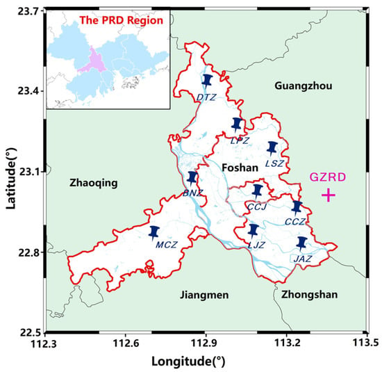
Figure 1.
Geographical distribution of the FTLLS and WSR-98D. The map shows the locations of nine substations and the Guangzhou radar station. The location of the PRD region and Foshan city are shown in light blue and purple at the top left corner.
In addition, the FTLLS can identify the ground strike points of CG strokes and can readily distinguish CG events (applied to flashes between cloud and earth), IC events (include flashes that do not terminate at the earth’s surface, including the intracloud discharge, intercloud discharge and air discharge) and NBEs (occurs either as the initiating event of an IC lightning flash or in isolation from other discharges in a storm) [24,25]. These are achieved by various waveform characteristics of lightning discharge, which include the rise time, fall time, pulse width, signal-to-noise ratio (SNR) and so on. The discrimination of lightning polarity can also be accomplished through the waveform. The height information is used to recognize the type of lightning along with the waveform. The detection system can also indiscriminately capture and distinguish the electric field changes produced by CG events and IC events.
From the initial operation result, it has shown good three-dimensional location accuracy and detection efficiency. A total of 27 lightning strokes, with 168 field waveforms included, were recorded by FTLLS to explain the transmission-line fault in the Foshan area [26]. In the rocket-triggered lightning experiment in Guangzhou, 38 return strokes in six triggered flashes were observed by nine sites of FTLLS to compare the differences between rocket-triggered lightning and subsequent return strokes in natural flashes [27]. Based on this system, the characteristics of lightning events under different circumstances in the Pearl River Delta region are available.
2.2. Data Classification
The analysis region is restricted to latitude 22° N–25° N and longitude 112° E–115° E, which is here characterized as the Pearl River Delta (PRD) region in Guangdong Province, South China. The PRD region is under the control of the subtropical monsoon climate with frequent heavy precipitation. Severe rainstorms and a high number of lightning flashes are found as the result of the joint action of multi-scale weather systems in the months from April to September, which are the hottest months of the year in this part of China. Under the background of favorable large-scale circulation, the mesoscale convective system has an obvious triggering effect on the rainstorm. Persistent heavy rainfall occurred from 17 May 2014 to 23 May 2014, especially in the central and eastern parts of the PRD region. It was recorded that 62 automatic weather stations had measured heavy precipitation of more than 100 mm on 17 May. A record-breaking 24 h rainfall of 477.4 mm started from 2000 LST (local standard time = UTC + 8 h) on 22 May during this heavy rainfall week [28,29]. Abundant lightning flashes are usually accompanied by heavy rainfall. In this paper, eight consecutive heavy rainfall days from 16 May 2014 to 23 May 2014 are selected to reveal the electrical structure of severe thunderstorms by using the IC events.
In this paper, the polarity definition of IC events is based on the atmospheric electricity sign convention, according to which a downward-directed electric field (or electric field change) vector is assumed to be positive [30]. We assume that the electrical waveforms with negative peaks were produced by the negative charge moving toward the positive charge, and vice versa.
As the convection of suspended moist air usually occurs only in the troposphere and the height of the tropopause is under 20 km in tropical summer regions, the IC flashes higher than 20 km are filtered out from the data set to eliminate a few mistaken triggers in FTLLS and minimal high-altitude flashes. The height of IC flashes lower than 1 km is also exclusive for the discrimination of CG flashes. Note that the occurrence of summer thunderstorms in the PRD region exhibits a strong diurnal cycle with the maximum frequency in the early afternoon [30], we choose the data from 11 A.M. to 9 P.M. for analysis. The IC flashes are classified by positive and negative polarities, and sorted in height from the lowest to the highest. The sorted height data are selected in different proportions for analysis, which is from 10% to 90%, 20% to 80% and 30% to 70%, respectively.
3. Results
3.1. Overview of Total Lightning Data
The lightning activities that occurred in the PRD region were observed from 16 May to 23 May by the Foshan Total Lightning Location System. Table 1 shows total lightning data and the environment temperature during the analysis period. According to the daily duration of the thunderstorms, the most severe and dense period was from 11 A.M. to 21 P.M. in a day. By different waveform characteristics and location information, total lightning can be classified into three categories of lightning events, which include CG events, IC events and narrow bipolar events (NBEs), respectively. More than 1.2 million events were detected by the system in the PRD region, of which 75.83% were IC events, 22.95% were CG events and 0.75% were NBEs. The maximum of total lightning events was over 218,505 on 17 May, almost twice that of total lightning on 19 May. IC events took the largest part of total lightning, accounting for more than 70% of each day. The NBEs made up only near 1%, which was extremely rare in MCSs. The temperature remained 23~32 °C for eight days, providing a stable synoptic environment for the study of eight consecutive thunderstorms.

Table 1.
Total lightning data and the environment temperature during 16–23 May.
Figure 2 displays the number of lightning events every 6 min during the analysis period. The time interval for frequency calculation was coordinated with the adjacent Doppler Radar scans. The lifetime of thunderstorms can be seen by the number of total lightning varying with time through the red solid line in Figure 2. The variation in IC events showed relatively high consistency with total lightning, which can be considered an effective way to observe the evolution of thunderstorms. The ratio of IC/Total Lightning maintained a high level in the developing stage and mature stage, which was above 0.65 in most cases, except for an unusually low proportion during the mature stage on 19 May. In the initial stage and dissipating stage, the IC ratio had a large fluctuation, either with an extremely low value near 0.2, or accounting for the whole proportion with no other categories of flashes.
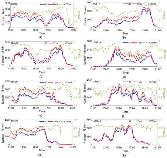
Figure 2.
Measured total lightning data for eight days: (a–h) Time series of total lightning, IC events and the ratio of IC/Total Lightning. The red and blue solid lines represent the numbers of total lightning and IC events, respectively, while the green dot line represents the ratio of IC events to total lightning. The label in the upper left corner is the date of the thunderstorm.
Figure 3 demonstrates the height distribution versus time in each day, with the color representing the number of IC events per six-minute interval. In the temperature range of 0 to −40 °C, liquid water and ice particle coexist forming a mixed-phase region where most electrification is thought to occur [31]. The environment temperatures of 0 °C and −40 °C were 3.5 km and 10.5 km, respectively. The largest number of IC events concentrated on 8–13 km with the number over 150 in the time interval of 6 min during eight days, except on 20 May when the frequency was lower than other days and the maximum only reached 138. This indicates that the collisions between cloud particles and the electrification process existed mainly in the area where lightning events gather at the height between 8 and 13 km. It has been discovered by ample observational evidence that the higher lightning frequency may be related to the higher surface temperature and higher cloud heights [32,33]. Noted that before or after the most severe period of thunderstorms (also the periods with high lightning frequency), the IC events are located at a much higher altitude. For example, during the period from 15:00 to 17:00 in Figure 3b, the altitude of the thunderstorm is between 12 and 15 km, which is much higher than that of the more severe part of the storm from 17:30 to 20:30. This may serve as a robust precursor to predict the beginning or dissipating of thunderstorms.
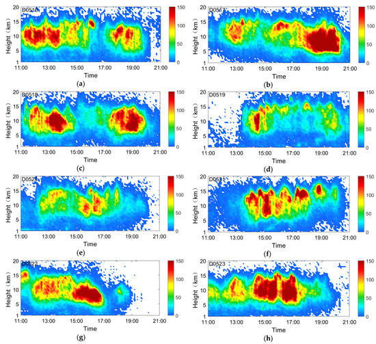
Figure 3.
Overview of height distribution and number in eight days: (a–h) IC events data from 11:00 to 21:00, colored by frequency. The color scale of lightning frequency is qualitative, with red being most events and blue least.
3.2. Height Distribution in Various Proportion Ranges
The lightning activity on 16 May 2014 was chosen as a representative example to be analyzed in detail. A total of 110,369 IC events were detected by FTLLS from 11:00 to 21:00 in the PRD region. The distribution of IC events and the discrimination of electrical structures in height were analyzed by making a comparison of different proportions of height and time intervals.
The lightning distribution corresponding to radar reflectivity is shown in Figure 4. Total flash initiations in MCSs tended to occur in or near regions with the larger values of base-scan reflectivity corresponding to regions of deep convection [34]. The total lightning events were located at the area where the radar reflectivity is >50 dBZ in the initiating stage in Figure 4a. As the thunderstorm developed, a large number of lightning events occurred in the 30 dBZ echo area (Figure 4b,c). In its dissipating stage when the reflectivity was <35 dBZ, the thunderstorm gradually disappeared with dispersed lightning events.
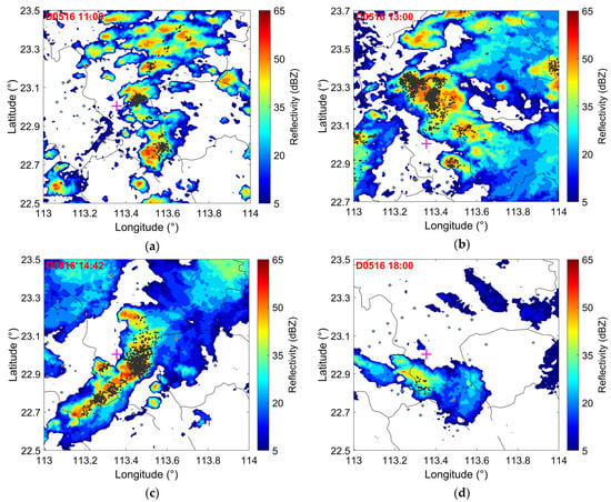
Figure 4.
Staking chart of radar echo and lightning location. Radar reflectivity at a different time within the analysis area. The black dots show the spatial distribution of total lightning on 16 May. (a) The thunderstorm was in its initiating stage when the reflectivity was >50 dBZ without corresponding lightning events in some place. (b,c). The thunderstorm was in its active stage when the reflectivity was >40 dBZ with quantities of lightning events. (d) The thunderstorm was in its dissipating stage when the reflectivity was <35 dBZ with dispersed lightning events.
Table 2 shows the average height range and the median height of positive and negative IC events with three types of percentage ranges, which are 10–90%, 20–80% and 30–70%. In the proportion from 10% to 90%, the positive IC events are found to spread over a large region in height from 6.1 to 13.4 km, while the negative IC events lie in the height from 3.7 to 13.1 km. The height between 6.1 and 13.1 km is defined as the overlapping area of positive and negative IC events. The median heights of positive and negative IC events are 10.2 and 8.1 km.

Table 2.
The average height of IC events on 16 May 2014.
The specific height distributions of positive and negative IC events during the analysis period are depicted in Figure 5. It shows the height range and the median height of positive and negative IC events with three types of percentage ranges, which are 10–90%, 20–80% and 30–70%, and four types of time intervals, which are 6 min, 15 min, 30 min and 1 h. The blue, pink and green rectangles represent the height of IC events in positive, negative and both polarities. It can be seen that thunderstorms are dominated by the dipole structure in vertical, with the positive charge region above the negative charge region. The inverted dipole and tripolar structure mainly occur when the thunderstorm starts and disappears. This anomalous structure is usually associated with large volumes of strong updrafts and convective positive CG flashes in the MCSs [35].
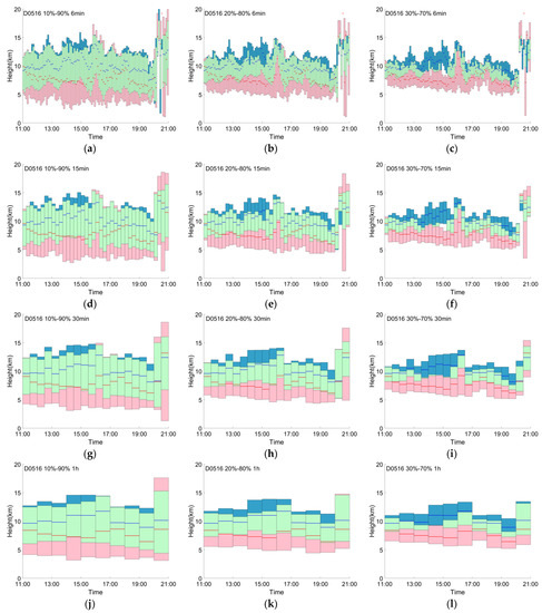
Figure 5.
Electrical structure on 16 May: (a–c) The height range of positive and negative IC events versus time with three types of proportions every 6 min for 10 h within the area of 300 km × 300 km. (d–f) Same, except with the time interval of 15 min. (g–i) Same, except with the time interval of 30 min. (j–l) Same, except with the time interval of 1 h. The pink part denotes sources in the region with only negative IC events, and the blue part with only positive IC events. The green part denotes sources with both positive and negative IC events. The red solid lines represent the median height of the sorted negative IC events, and the blue solid lines represent the median height of the sorted positive IC events.
At the beginning of the lightning activity, the IC events stayed at a relatively low height between 5.2 and 11.4 km. After 30 min, the positive IC events gradually rose to a height higher than 12 km while the median height reached near 11 km, which indicates an increase in the vertical development of the lightning activity; although, the negative IC events were at lower heights compared with the first hour of lightning activity of the thunderstorm. The height range was extremely high when the electrical structure became inverted with the negative IC events reaching 17 km at 16:12.
Figure 5a–c demonstrates the height distribution at a 6-minute interval. The inverted tripolar structure is seen in the initial stage at 11:00 and dissipating stage at 20:00, with a higher negative charge region above the positive charge region. A temporary inverted dipole structure emerges at 19:48, but existed just for a few minutes. The median height of positive IC events is unnaturally lower than the negative during these two periods, which is slightly different from the inverted tripolar structure in the mature stage from 15:36 to 18:00 when the median height of positive IC events is still higher than the negative as normal dipole structure. All median heights, from 15:36 to 18:00 and from 20:00 to 21:00 when the charge structure becomes inverted, are higher than the time in the dipole charge structure.
In the time interval of 30 min and 1 h (Figure 5g–l), the dipole structure is more obvious as all the median heights of positive IC events are higher than that of the negative, which indicates that the electrical structure is very stable in the whole thunderstorm process, with very few time periods when the polarity becomes inverted. For the time intervals of 15 min, we can also obtain the overall trend of the thunderstorm structure without losing sight of the details during the analysis period. With the proportion of 30–70% in Figure 5c,f, the dipolar charge structure is clearer when the charge region of positive IC events is separated from the negative at 15:00 compared with other proportions. However, some details can be neglected if the sample is small. The inverted tripolar structure is indistinct at 16:00 in Figure 5c,f,i,l, with the proportion of IC events being 30–70%.
As the height proportion of 10–90% exists quite a few IC events higher than the convection area in Figure 5a, and the statistical data with the height proportion between 30% and 70% cannot exhibit the integrated structure of thunderstorm, we take the height proportion of 20–80% as the height range to study the characteristics of eight consecutive summer thunderstorms in PRD region.
3.3. Electrical Structure during Eight Thunderstorm Days
The electrical structures in the PRD region are analyzed on eight consecutive thunderstorm days from 16 May 2014 to 23 May 2014. Figure 6 contains the distribution of the number of IC events in height. In order to compare the distribution characteristics on different time scales (1 h, 5 h and 10 h), the log function is used to shorten the distance of the y-axis. Using different log functions enables the positive IC events located in the upper part of the picture and the negative ones located in the lower part. The number of positive IC events is processed by the natural logarithm (lines with circles), while the number of negative IC events is processed by the denary logarithm (lines with diamonds). The variation in both positive and negative IC events can be compared by this method. The solid red lines show the number of IC events versus height during the whole 10 h, with the dark blue chain-dotted lines in the first 5 h (from 11:00 to 16:00) and the light blue chain-dotted lines in the second 5 h (from 16:00 to 21:00). The dot lines represent the distribution of IC events in 60 min from 11:00 to 21:00.
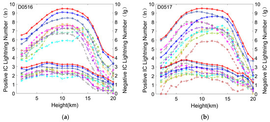
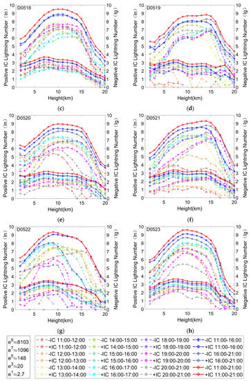
Figure 6.
The number of IC events with the height in various time intervals: (a–h) The number of positive IC events is processed by the natural logarithm (the left y-axis), while the number of negative IC events is processed by the denary logarithm (the right y-axis). Lines marked with circles belong to the positive events, and lines marked with diamonds represent the negative events. The solid red lines show the number of IC events versus height during the whole 10 h, with the dark blue chain-dotted lines in the first 5 h (from 11:00 to 16:00) and the light blue chain-dotted lines in the second 5 h (from 16:00 to 21:00). The dot lines represent the distribution of IC events in 60 min from 11:00 to 21:00.
The number of positive IC events gradually increases at first, peaks at near 11 km and then drops rapidly; however, the trend of negative IC events differs from the positive. The variation in the number of negative IC events presents a saddle shape. There is more than one peak as the height rises, with the first peak at around 6 km and the second peak over 15 km. The maximum number of positive IC events is located at the height between 10 and 15 km, with the negative events lying at the height between 6 and 8 km. The height corresponding to a large amount of positive IC events usually lasts for two or three kilometers as is seen in Figure 6b,d,e. The distributions of the number do not vary as significantly in 10 h, 5 h and 1 h, except that the number of IC events presents some differences with the evolution of thunderstorms. This indicates that no matter what stage the thunderstorm is on, the overall height distribution of positive and negative IC events stays stable.
Table 3 shows the ranges of average height in the proportion from 20% to 80% and the median heights on eight thunderstorm days. The positive IC events in 8 days lie in the average height between 7.5 and 12.3 km, while the negative IC events are located between 5.4 to 11.4 km. The average median heights of positive and negative IC events are 10 and 7.9 km, which indicates that the positive charge area is obviously higher than the negative. The height range on 21 May is higher than that on other days in both polarities; however, the height range of positive IC events does not show much tendency on 19 May when the negative IC events are lower than the average. In different time intervals, the distributions of IC events do not vary much, with only approximately 0.1 km changes, showing that the height of events keeps stable in the troposphere.

Table 3.
The average height distributions of IC events on 8 consecutive thunderstorm days with the proportion range from 20% to 80%.
The height ranges of IC events in positive and negative polarities with a proportion from 20% to 80% were displayed in Figure 7 for eight thunderstorm days. The overall distribution of positive and negative IC events in the eight days is quite similar to each other, showing a dipole structure with the positive charge regions being higher than the negative ones, which indicates that the electrical structure in the PRD region remains dipole during the summer season. This finding supports the basic inference of Liu et al. [36] that the thunderstorm cloud structure in the south part of China is dipole and contributes to the further study of thunderstorm electrification in the tropics. The height with the largest number of events lies in the middle part of the height range for the positive events, which is not the case for the negative, with the largest number lying in the lower part of the overall height range. The color of the positive IC rectangle is dominated by green and blue, while the color of the negative IC rectangle is dominated by red and yellow, indicating that the number of positive IC events is much larger than the negative ones.
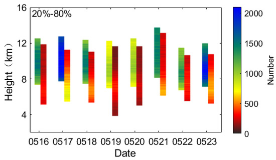
Figure 7.
Summary of electrical structure in eight days. For each day, the height distributions of positive IC events located on the left are mainly colored in green and blue, while the negative ones located on the right are mainly colored in yellow and dark red.
4. Discussion and Conclusions
This paper makes a detailed analysis of the electrical structure of thunderstorms in the warm season over the PRD region using the IC flashes detected by VLF/LF total lightning data from 16 May 2014 to 23 May 2014, which helps us have a better understanding of the characteristics of the summer thunderstorms in the south of China. The location performance of FTLLS within the coverage area has been tested by the Monte Carlo simulation method. It is found that the error of location accuracy is less than 100 m in the horizontal and 200 m in the vertical within the network [37]. The detection efficiencies of the FTLLS are compared with the LLS of the Guangdong power grid in Guangdong Province based on the directly measured current data at the triggering lightning site. The result shows that the detection efficiencies of the FTLLS for flashes and for return strokes were 87.5% (7/8) and 93.0% (40/43), respectively [38]. The rationality of the location system has been verified by the radar-lightning comparison in a horizontal section [21]. The radar data are obtained from China’s Weather Surveillance Doppler-1998 (WSR-98D) at Guangzhou (in Figure 1). With stronger radar echo in the area, the convection activity is more frequent and the corresponding detected lightning frequency is much larger [39].
Most VLF/LF lightning location systems, the capability of which is to detect the CG flashes, serve as the assistant observation for LMA to explain certain processes inside the clouds and determine their corresponding altitude, polarity and peak current. The typical tripole charge structure of thunderstorms that passed through southeast France during the first Special Observation Period of the Hydrological Cycle in the Mediterranean Experiment (HyMeX) was investigated with the EUCLID network to complement HyMeX LMA [39,40,41]. López et al. [19] documented a similar tripole charge structure in Columbia by using the Colombia Lightning Mapping Array (COL-LMA), with the Columbia Total Lightning Detection Network (TLDN) applied for the CG lightning activity data. However, this study is based on FTLLS, which locates radio emissions in VLF/LF but records 3-D information of lightning including IC flashes, CG flashes and NBE, also successfully revealing the electrical structure of thunderstorms.
The analyzed period chosen in this paper is from 11 A.M. to 21 P.M., which is based on the monthly and daily diurnal cycles over the PRD region studied by Chen et al. [42] using 3 years of operational radar data. They found that there was a bimodal diurnal distribution of warm-season convection in this area during May and June, with the maximum lightning flashes in the early afternoon, and a secondary peak between midnight and early morning, which was consistent with the analysis period we choose. The same daily diurnal distribution of summer thunderstorms shown by lightning frequency was also found by Zhang et al. [43] using the GDLLS data and the weather station observation in the PRD region, with the first peak value from 12:00 to 20:00 and the second one from 0:00 to 5:00.
The relationships between conventional radar reflectivity, storm electrification and lightning have been studied by many researchers [44,45]. Altitude or volume of 40 dBZ echo corresponded to a high probability of lightning, while 30 dBZ contained about half of all no-lightning features [46]. However, radar thresholds might be different if total lightning were taken into consideration, owing to the occurrence of IC flashes typically preceding CG flashes. In this paper, total lightning events are applied to match up with radar reflectivity. Lightning data are highly consistent with the >40 dBZ echo, which means the rationality of our VLF/LF LLS, except for some slight deviation between the area with the highest concentration of lightning and the area with the highest radar reflectivity.
The differences in height range in four types of time intervals, and three types of proportions are compared. The average distributions of IC flashes in our eight thunderstorm days are located in the altitude between 5.4 and 12.3 km, with the positive IC events lying in the average height between 7.5 and 12.4 km and the negative IC events located between 5.4 and 11.3 km. This result tends to support the observation by Van der Velde and Montanyà [47] who made a classification by the type of flashes to explain the tripole charge structure in Spain. The positive IC flashes showed the positive charge over negative charge in the upper half of a tripole charge configuration with the positive initiation at 10–12 km and the negative initiation at 6 km, while the negative CG and IC flashes involved the lower half of the tripole charge structure with the negative initiation at 6 km and the lower positive initiation 3 km.
The overall height regions of thunderstorms in north-central Florida are much lower than that of thunderstorms in our study, both in the maximum and minimum height [48]. All the two summer multicell storms and three winter/spring frontal storms showed the tripole structure but at different heights. The lower positive charge region in summer thunderstorms was between 3 and 6.8 km, with the main negative charge region between 5 and 7.9 km and the upper positive charge region between 6.8 and 10 km. In winter/spring frontal storms, the height ranges of all charge regions were up to 1 km lower in altitude than that in summer storms, with the charge region from lower to higher being 2.3–5.1 km, 4.2–6.3 km and 5.2–9.5 km.
Both Zheng et al. [49] and Ribaud et al. [41] found that a typical tripole charge structure was deduced to dominate the convective areas, whereas a dipole structure with low charge heights was deduced in the stratiform areas. The spatial distribution of lightning radiation sources was observed by SAFIR 3000 and a regional CG lightning location network (CGLLN) in Hubei, China. For the convective region, there were two regions of positive charge, occurring at the altitude from 9 km to 10 km, and at around 4 km, with the main region of negative charge occurring between 6 and 7.5 km. For the stratiform region, the main electrical structure was dipolar and the charge regions occurred at low heights. The positive and negative charge regions ranged from 6 to 7.5 km and from 4 to 6 km, respectively.
The inverted polarity storm is defined as a reversed dipole structure, yielding a midlevel positive charge layer and upper-level negative layer [50,51]. The Severe Thunderstorm Electrification and Precipitation Study (STEPS) project observed by Lang and Rutledge [35] shows an inverted dipole in the stratiform area. During the first 3 h within the convective line, charge identification revealed the electrical structure evolution from a normal polarity dipole (upper positive charge near 9 km over a mid-level negative charge near 7 km) to a normal polarity tripole (with the addition of lower positive charge near 4 km). The charge structure exhibited an inverted dipole, with a negative charge (10 km) overlaying positive (6 km) in the last 2 h. It was found that the intensity of the convection was the factor of the relative altitudes of charge layers. Part of the storms associated with severe wind and predominately positive CG flashes developed an inverted tripole charge structure, which was a good complement for the study of Van der Velde and Montanyà.
Thirty single-cell and multicell storms in the West Texas region were examined by Chmielewski et al. [2]. The charge structure showed the normal pattern in some storms, with a negative charge at 6–10 km, higher positive above 10 km and lower positive below 6 km, while in other storms, there was a clearly anomalous pattern, with a net positive charge at 7–10 km, and negative above. No statistical difference was observed in the average storm flash rate or size between the anomalously and normally electrified storms except for the lower fraction of ground strikes produced out of anomalous storms. The thunderstorms in the summer season over the PRD region show the dipole charge structure in the developing stage and mature stage, while the inverted dipole and tripole charge structures are found in the initial stage and dissipating stage. The dipole structure of thunderstorms is consistent with the study in the literature, but the electrification of the anomalous inverted structure needs to be further studied in the future.
Author Contributions
J.W. and L.C. lead the observation team and focused on the analysis of the leader propagation. J.W., L.C., S.C. and Q.L. participated in the establishment of the Foshan total lightning system. J.W. and S.C. wrote the manuscript. Y.F., M.Z. and Y.H. revised and improved the text. All authors have read and agreed to the published version of the manuscript.
Funding
This research was funded by the Natural Science Foundation of China, grant number 51807144.
Institutional Review Board Statement
Not applicable.
Informed Consent Statement
Not applicable.
Data Availability Statement
The data archiving is underway and will be presented at the Zenodo repository. The data have been temporarily uploaded as Supporting Information for review purposes.
Acknowledgments
This work was supported by the National Natural Science Foundation of China (Grant Number: 51807144). The authors express their gratitude to all the members for their contribution to the lightning detection system.
Conflicts of Interest
The authors declare no conflict of interest.
References
- Stolzenburg, M.; Marshall, T.C. Charge structure and dynamics in thunderstorms. Space Sci. Rev. 2008, 137, 355–372. [Google Scholar] [CrossRef]
- Chmielewski, V.C.; Bruning, E.C.; Ancell, B.C. Variations of thunderstorm charge structures in West Texas on 4 June 2012. J. Geophys. Res. Atmos. 2018, 123, 9502–9523. [Google Scholar] [CrossRef] [Green Version]
- Fankhauser, J.C. Thunderstorm-environment interactions determined from aircraft and radar observations. Mon. Weather. Rev. 1971, 99, 171–192. [Google Scholar] [CrossRef]
- Cummins, K.L.; Krider, E.P.; Malone, M.D. The US National Lightning Detection Network/sup TM/and applications of cloud-to-ground lightning data by electric power utilities. IEEE Trans. Electromagn. Compat. 1998, 40, 465–480. [Google Scholar] [CrossRef] [Green Version]
- McCaul, E.W.; Buechler, D.E.; Hodanish, S.; Goodman, S.J. The Almena, Kansas, Tornadic Storm of 3 June 1999 A Long-Lived Supercell with Very Little Cloud-to-Ground Lightning. Mon. Weather Rev. 2002, 130, 407–415. [Google Scholar] [CrossRef]
- Clarke, S.G. The mechanism of a thunderstorm. Proc. R. Soc. Lond. A 1927, 114, 376–401. [Google Scholar]
- Simpson, G.C.; Scrase, F.J. The distribution of electricity in thunderclouds. Proc. R. Soc. Lond. Ser. A Math. Phys. Sci. 1937, 161, 309–352. [Google Scholar]
- Li, Y.; Zhang, G.; Wang, Y.; Wu, B.; Li, J. Observation and analysis of electrical structure change and diversity in thunderstorms on the Qinghai-Tibet Plateau. Atmos. Res. 2017, 194, 130–141. [Google Scholar] [CrossRef]
- Rust, W.D. Possibly inverted-polarity electrical structures in thunderstorms during STEPS. Geophys. Res. Lett. 2002, 29, 12. [Google Scholar] [CrossRef]
- Wiens, K.C.; Rutledge, S.A.; Tessendorf, S.A. The 29 June 2000 Supercell Observed during STEPS. Part II: Lightning and Charge Structure. J. Atmos. Sci. 2005, 62, 4151–4177. [Google Scholar] [CrossRef]
- Zheng, D.; Wang, D.; Zhang, Y.; Wu, T.; Takagi, N. Charge regions indicated by LMA lightning flashes in Hokuriku’s winter thunderstorms. J. Geophys. Res. Atmos. 2019, 124, 7179–7206. [Google Scholar] [CrossRef]
- Bruning, E.C.; Rust, W.D.; Schuur, T.J.; MacGorman, D.R.; Krehbiel, P.R.; Rison, W. Electrical and polarimetric radar observations of a multicell storm in TELEX. Mon. Weather Rev. 2007, 135, 2525–2544. [Google Scholar] [CrossRef]
- Rust, W.D.; Trapp, R.J. Initial balloon soundings of the electric field in winter nimbostratus clouds in the USA. Geophys. Res. Lett. 2002, 29, 20. [Google Scholar] [CrossRef] [Green Version]
- Stolzenburg, M.; Rust, W.D.; Marshall, T.C. Electrical structure in thunderstorm convective regions: 3. Synthesis. J. Geophys. Res. Atmos. 1998, 103, 14097–14108. [Google Scholar] [CrossRef]
- Rison, W.; Thomas, R.J.; Krehbiel, P.R.; Hamlin, T.; Harlin, J. A GPS-based three-dimensional lightning mapping system: Initial observations in central New Mexico. Geophys. Res. Lett. 1999, 26, 3573–3576. [Google Scholar] [CrossRef] [Green Version]
- Thomas, R.J.; Krehbiel, P.R.; Rison, W.; Hamlin, T.; Boccippio, D.J.; Goodman, S.J.; Christian, H.J. Comparison of ground-based 3-dimensional lightning mapping observations with satellite-based LIS observations in Oklahoma. Geophys. Res. Lett. 2000, 27, 1703–1706. [Google Scholar] [CrossRef] [Green Version]
- Hager, W.W.; Aslan, B.C.; Sonnenfeld, R.G.; Crum, T.D.; Battles, J.D.; Holborn, M.T.; Ron, R. Three-dimensional charge structure of a mountain thunderstorm. J. Geophys. Res. 2010, 115. [Google Scholar] [CrossRef] [Green Version]
- Liu, D.; Qie, X.; Peng, L.; Li, W. Charge structure of a summer thunderstorm in North China: Simulation using a Regional Atmospheric Model System. Adv. Atmos. Sci. 2014, 31, 1022–1034. [Google Scholar] [CrossRef]
- López, J.A.; Montanyà, J.; Velde, O.A.; Pineda, N.; Salvador, A.; Romero, D.; Aranguren, D.; Taborda, J. Charge structure of two tropical thunderstorms in Colombia. J. Geophys. Res. Atmos. 2019, 124, 5503–5515. [Google Scholar] [CrossRef]
- Bruning, E.C.; Rust, W.D.; MacGorman, D.R.; Biggerstaff, M.I.; Schuur, T.J. Formation of Charge Structures in a Supercell. Mon. Weather Rev. 2010, 138, 3740–3761. [Google Scholar] [CrossRef]
- Cai, L.; Zou, X.; Wang, J.; Li, Q.; Zhou, M.; Fan, Y. The Foshan Total Lightning Location System in China and its initial operation results. Atmosphere 2019, 10, 149. [Google Scholar] [CrossRef] [Green Version]
- Pilkey, J.T.; Uman, M.A.; Hill, J.D.; Ngin, T.; Gamerota, W.R.; Jordan, D.M.; Caicedo, J.; Hare, B. Rocket-triggered lightning propagation paths relative to preceding natural lightning activity and inferred cloud charge. J. Geophys. Res. Atmos. 2014, 119, 13–56. [Google Scholar] [CrossRef]
- Stolzenburg, M.; Marshall, T.C.; Krehbiel, P.R. Initial electrification to the first lightning flash in New Mexico thunderstorms. J. Geophys. Res. Atmos. 2015, 120, 253–276. [Google Scholar] [CrossRef]
- Prentice, S.A.; Mackerras, D. The Ratio of Cloud to Cloud-Ground Lightning Flashes in Thunderstorms. J. Appl. Meteorol. Climatol. 1977, 16, 545–550. [Google Scholar] [CrossRef] [Green Version]
- Rison, W.; Krehbiel, P.R.; Stock, M.G.; Edens, H.E.; Shao, X.-M.; Thomas, R.J.; Stanley, M.A.; Zhang, Y. Observations of narrow bipolar events reveal how lightning is initiated in thunderstorms. Nat. Commun. 2016, 7, 10721. [Google Scholar] [CrossRef] [Green Version]
- Cai, L.; Zou, X.; Wang, J.; Li, Q.; Zhou, M.; Fan, Y.; Yu, W. Lightning electric-field waveforms associated with transmission-line faults. IET Gener. Transm. Distrib. 2019, 14, 525–531. [Google Scholar] [CrossRef]
- Wang, J.; Li, Q.; Cai, L.; Zhou, M.; Fan, Y.; Xiao, J.; Sunjerga, A. Multiple-station measurements of a return-stroke electric field from rocket-triggered lightning at distances of 68–126 km. IEEE Trans. Electromagn. Compat. 2019, 61, 440–448. [Google Scholar] [CrossRef]
- Bingzhi Zheng, F.W.; Yiming, H. Analysis of Severe Convective Weather Process in Guangdong on 17 May 2014. Guangdong Meteorol. 2015, 37, 10–14. (In Chinese) [Google Scholar]
- Zhongqing Liang, J.C.; Lv, L. Analysis on the Causes of the “May 23” Heavy Rain in Qingyuan. Guangdong Meteorol. 2015, 4, 1–5. (In Chinese) [Google Scholar]
- Leal, A.F.R.; Rakov, V.A.; Rocha, B.R.P. Compact intracloud discharges: New classification of field waveforms and identification by lightning locating systems. Electr. Power Syst. Res. 2019, 173, 251–262. [Google Scholar] [CrossRef]
- Rakov, V.A. Electrical structure of thunderclouds. In Fundamentals of Lightning; Cambridge University Press: Cambridge, MA, USA, 2016; pp. 31–51. [Google Scholar]
- Price, C.G. Lightning applications in weather and climate research. Surv. Geophys. 2013, 34, 755–767. [Google Scholar] [CrossRef]
- Murray, L.T. An uncertain future for lightning. Nat. Clim. Change 2018, 8, 191–192. [Google Scholar] [CrossRef]
- Makowski, J.A.; MacGorman, D.R.; Biggerstaff, M.I.; Beasley, W.H. Total lightning characteristics relative to radar and satellite observations of oklahoma mesoscale convective systems. Mon. Weather Rev. 2013, 141, 1593–1611. [Google Scholar] [CrossRef]
- Lang, T.J.; Rutledge, S.A. Kinematic, microphysical, and electrical aspects of an asymmetric bow-echo mesoscale convective system observed during STEPS 2000. J. Geophys. Res. 2008, 113. [Google Scholar] [CrossRef] [Green Version]
- Liu, Y.; Chan, L.Y.; Lin, Q.; Feng, W.; Bi, X.; Chen, J.; Tao, H.; Wang, X.; Chen, D.; Sheng, G.; et al. Physical and observable characteristics of cloud-to-ground lightning over the Pearl River Delta region of South China. J. Geophys. Res. Atmos. 2014, 119, 5986–5999. [Google Scholar] [CrossRef]
- Cai, L. Ground-Based VLF/LF Three-Dimensional Total Lightning Location Technology. Ph.D. Thesis, Wuhan University, Wuhan, China, 2013. [Google Scholar]
- Li, Q.; Wang, J.; Cai, L.; Zhou, M.; Fan, Y. On the return-stroke current estimation of Foshan Total Lightning Location System (FTLLS). Atmos. Res. 2021, 248, 105194. [Google Scholar] [CrossRef]
- Lagouvardos, K.; Kotroni, V.; Defer, E.; Bousquet, O. Study of a heavy precipitation event over southern France, in the frame of HYMEX project: Observational analysis and model results using assimilation of lightning. Atmos. Res. 2013, 134, 45–55. [Google Scholar] [CrossRef]
- Defer, E.; Pinty, J.P.; Coquillat, S.; Martin, J.M.; Prieur, S.; Soula, S.; Richard, E.; Rison, W.; Krehbiel, P.; Thomas, R.; et al. An overview of the lightning and atmospheric electricity observations collected in southern France during the HYdrological cycle in Mediterranean EXperiment (HyMeX), Special Observation Period 1. Atmos. Meas. Tech. 2015, 8, 649–669. [Google Scholar] [CrossRef] [Green Version]
- Ribaud, J.F.; Bousquet, O.; Coquillat, S. Relationships between total lightning activity, microphysics and kinematics during the 24 September 2012 HyMeX bow-echo system. Q. J. R. Meteorol. Soc. 2016, 142, 298–309. [Google Scholar] [CrossRef] [Green Version]
- Chen, X.; Zhao, K.; Xue, M. Spatial and temporal characteristics of warm season convection over Pearl River Delta region, China, based on 3 years of operational radar data. J. Geophys. Res. Atmos. 2014, 119, 447–465. [Google Scholar] [CrossRef]
- Zhang, C.Y.; Mai, B.R.; Huang, Y.G.; Wen, N.Z. Temporal and spatial characteristics of lightning in Guangdong region. In Proceedings of the 2014 International Conference on Lightning Protection (Iclp), Kampala, Uganda, 11–18 October 2014; pp. 1173–1176. [Google Scholar]
- Gremillion, M.S.; Orville, R.E. Thunderstorm Characteristics of Cloud-to-Ground Lightning at the Kennedy Space Center, Florida: A Study of Lightning Initiation Signatures as Indicated by the WSR-88D. Weather Forecast. 1999, 14, 640–649. [Google Scholar] [CrossRef]
- Stano, G.T.; Fuelberg, H.E.; Roeder, W.P. Developing empirical lightning cessation forecast guidance for the Cape Canaveral Air Force Station and Kennedy Space Center. J. Geophys. Res. Atmos. 2010, 115. [Google Scholar] [CrossRef] [Green Version]
- Lang, T.J.; Rutledge, S.A. A Framework for the Statistical Analysis of Large Radar and Lightning Datasets: Results from STEPS 2000. Mon. Weather Rev. 2011, 139, 2536–2551. [Google Scholar] [CrossRef]
- van der Velde, O.A.; Montanyà, J. Asymmetries in bidirectional leader development of lightning flashes. J. Geophys. Res. Atmos. 2013, 118, 504–519. [Google Scholar] [CrossRef]
- Caicedo, J.A.; Uman, M.A.; Pilkey, J.T. Lightning evolution in two north Central Florida summer multicell storms and three winter/spring frontal storms. J. Geophys. Res. Atmos. 2018, 123, 1155–1178. [Google Scholar] [CrossRef] [Green Version]
- Zheng, D.; Zhang, Y.; Meng, Q.; Lu, W.; Zhong, M. Lightning activity and electrical structure in a thunderstorm that continued for more than 24 h. Atmos. Res. 2010, 97, 241–256. [Google Scholar] [CrossRef]
- Tessendorf, S.A. Characteristics of lightning in supercells. In Lightning: Principles, Instruments and Applications; Springer: Dordrecht, The Netherlands, 2009. [Google Scholar]
- Bruning, E.C.; Weiss, S.A.; Calhoun, K.M. Continuous variability in thunderstorm primary electrification and an evaluation of inverted-polarity terminology. Atmos. Res. 2014, 135, 274–284. [Google Scholar] [CrossRef]
Publisher’s Note: MDPI stays neutral with regard to jurisdictional claims in published maps and institutional affiliations. |
© 2022 by the authors. Licensee MDPI, Basel, Switzerland. This article is an open access article distributed under the terms and conditions of the Creative Commons Attribution (CC BY) license (https://creativecommons.org/licenses/by/4.0/).