
Dynamics of Precipitation Anomalies in Tropical South America


Abstract
:1. Introduction
2. Data and Methods
2.1. Data
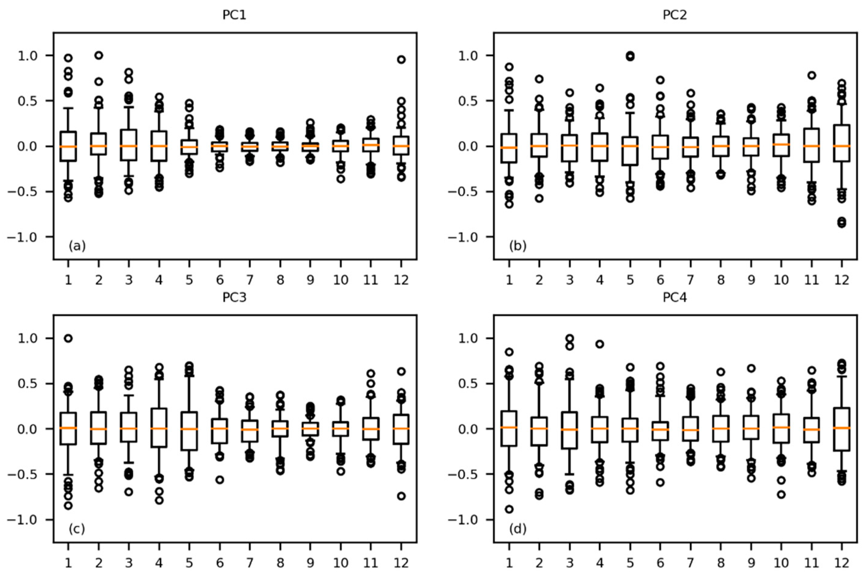
2.2. Methods
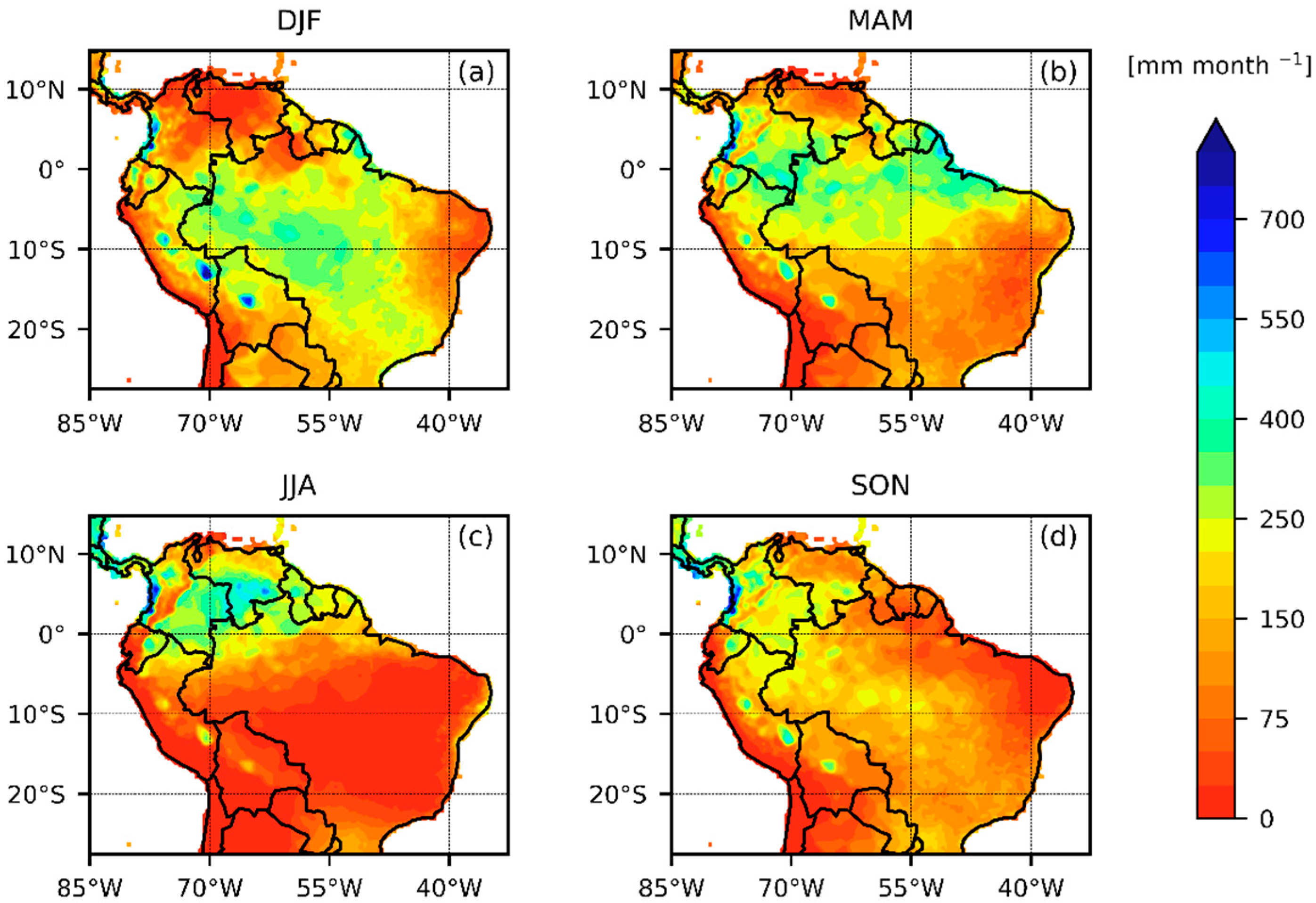
3. Results and Discussion
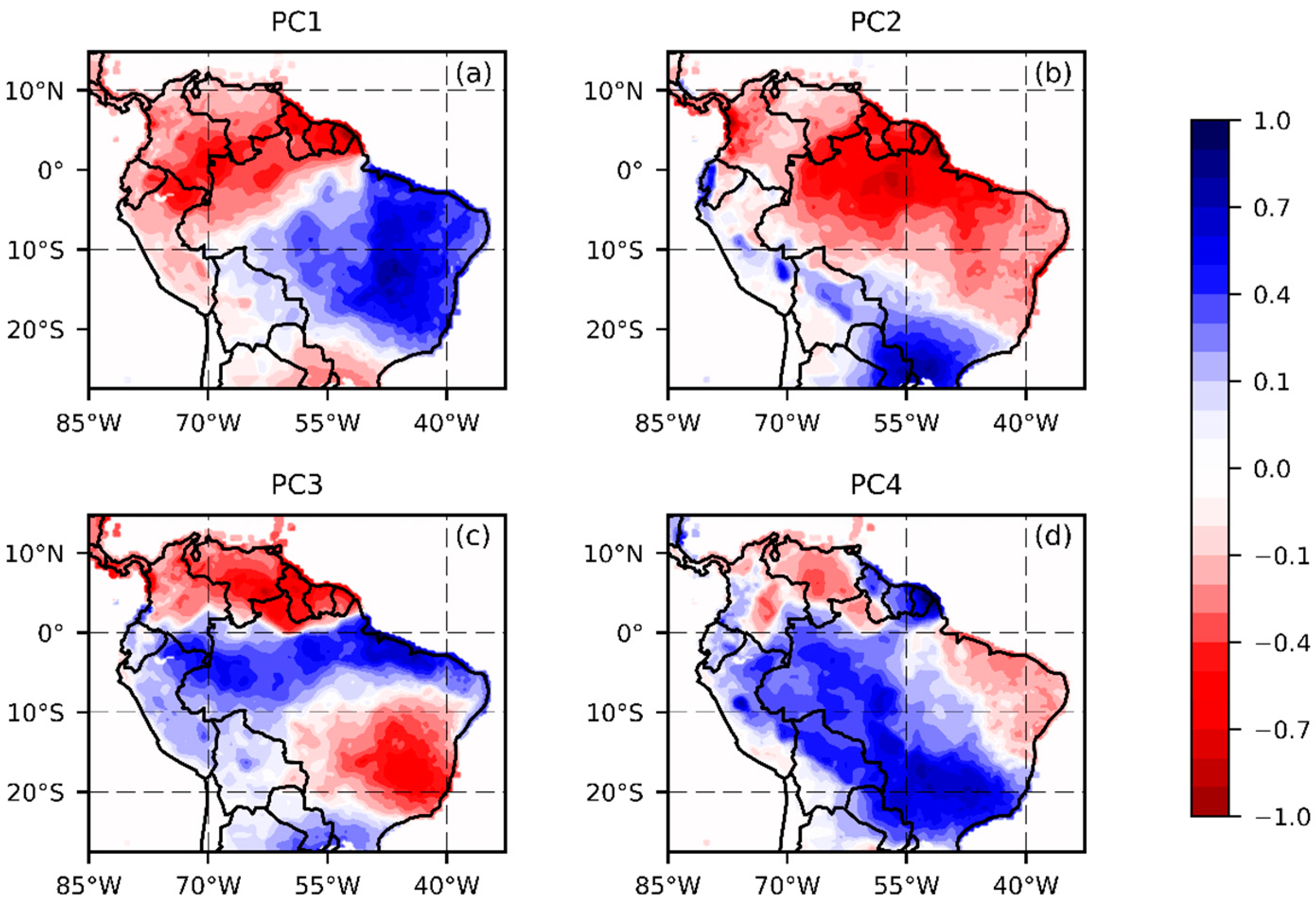
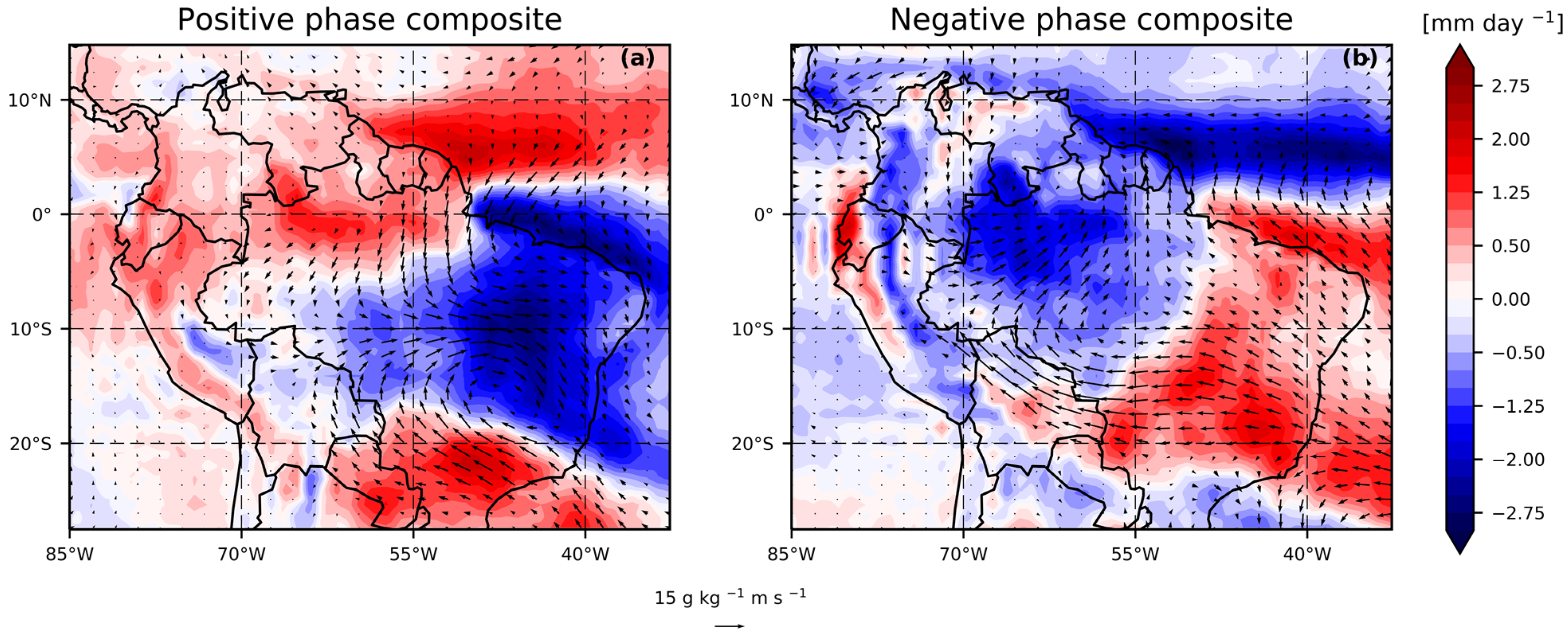
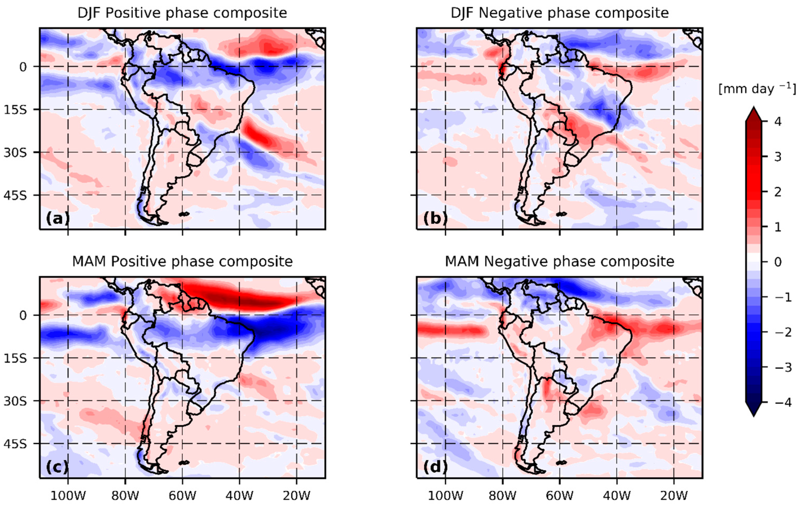
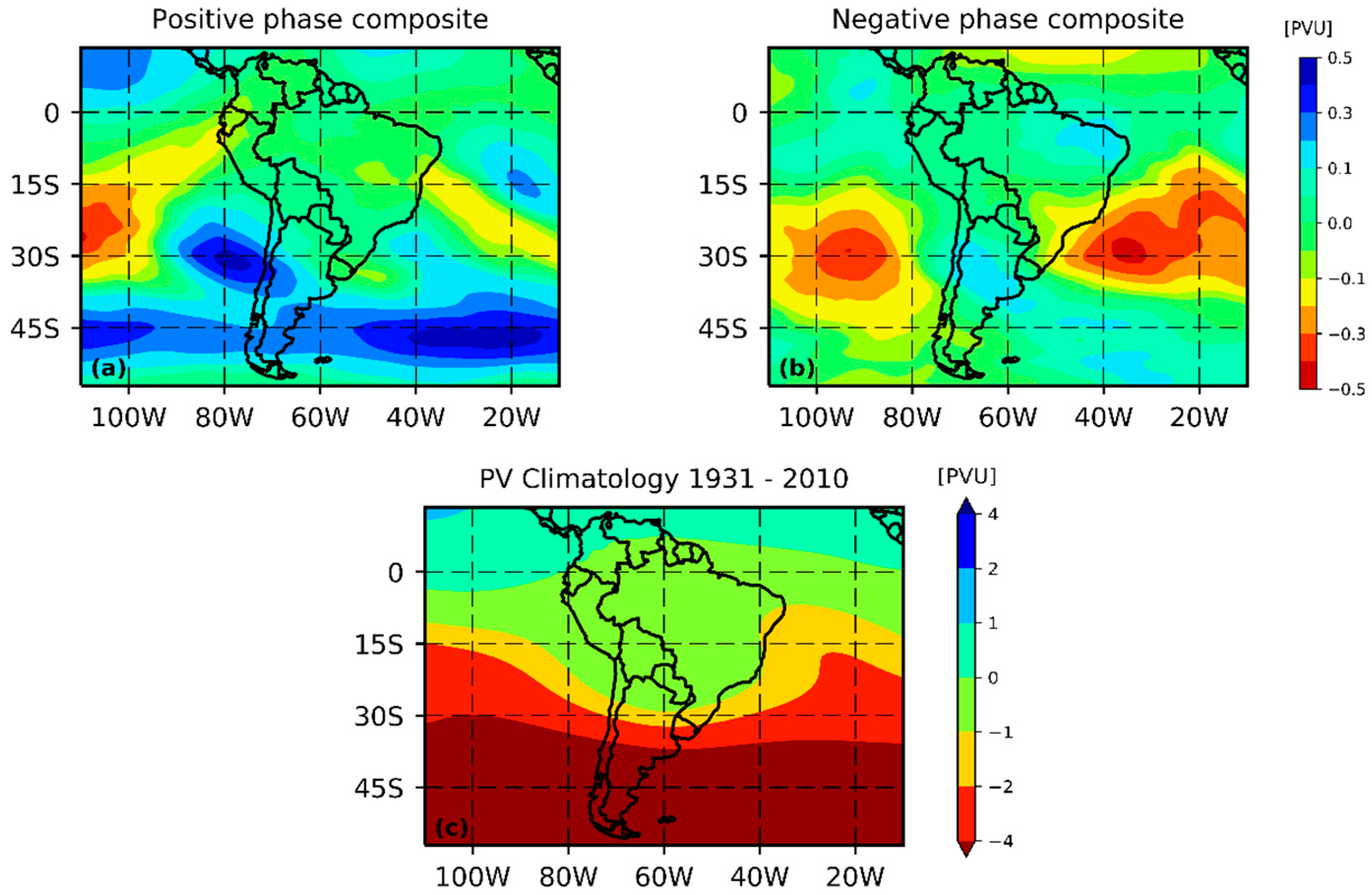
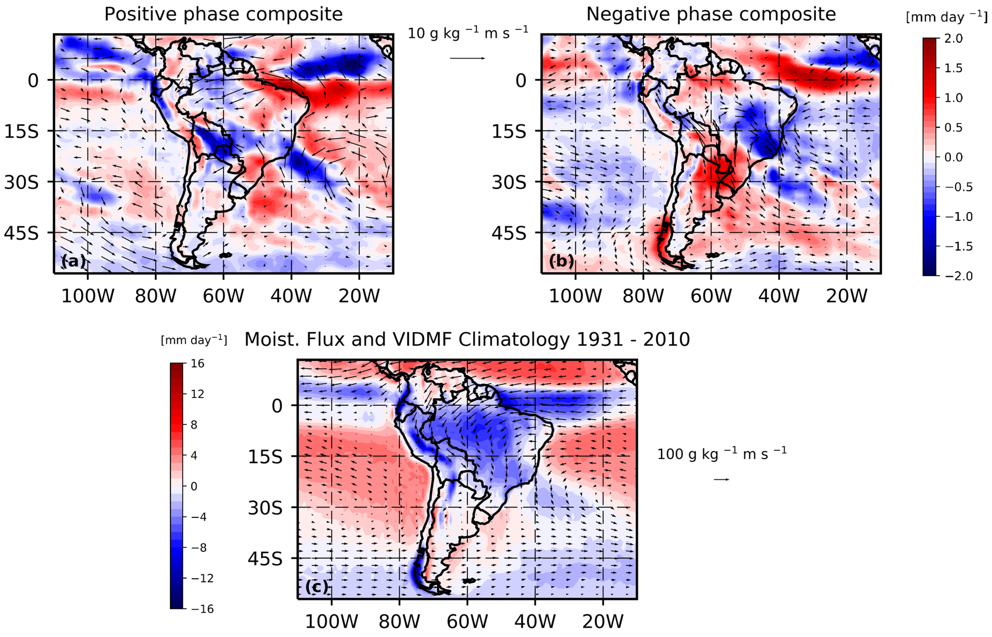
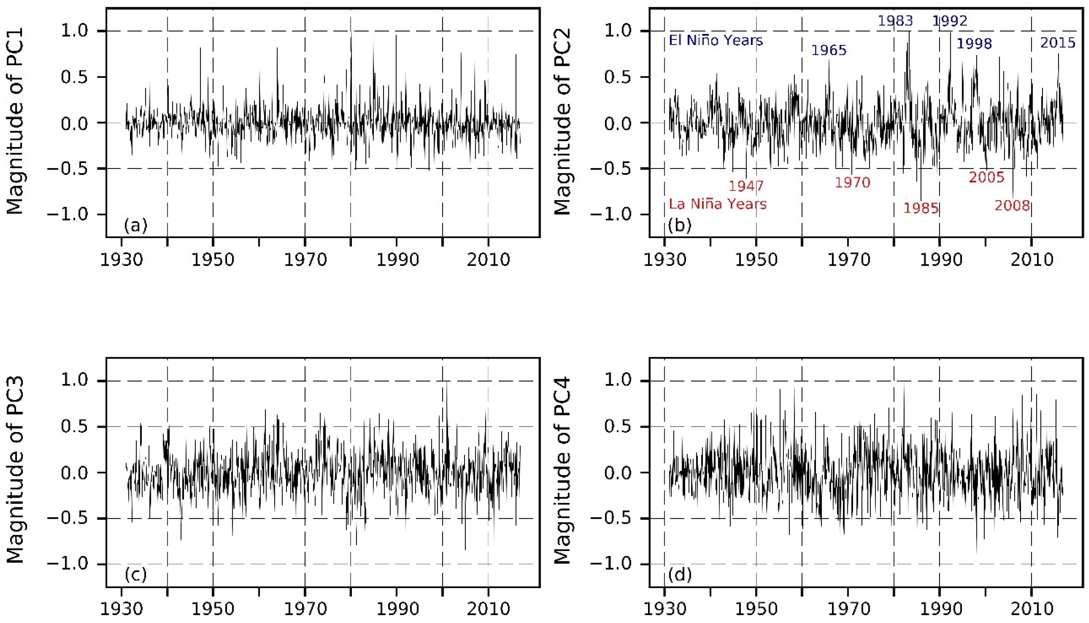
3.1. First Principal Component: South Atlantic Convergence Zone (SACZ) Intensity
3.2. Second Principal Component: ENSO
3.3. Third Principal Component—Meridional shift of the Atlantic ITCZ and SACZ
3.4. Fourth Principal Component—South American Monsoon System
4. Conclusions
Supplementary Materials
Author Contributions
Funding
Institutional Review Board Statement
Informed Consent Statement
Data Availability Statement
Acknowledgments
Conflicts of Interest
References
- Gagnon, A.S.; Smoyer-Tomic, K.E.; Bush, A.B.G. The El Niño Southern Oscillation and Malaria Epidemics in South America. Int. J. Biometeorol. 2002, 46, 81–89. [Google Scholar] [CrossRef]
- Marengo, J.A.; Espinoza, J.C. Extreme Seasonal Droughts and Floods in Amazonia: Causes, Trends and Impacts. Int. J. Climatol. 2016, 36, 1033–1050. [Google Scholar] [CrossRef]
- Garreaud, R.D.; Vuille, M.; Compagnucci, R.; Marengo, J. Present-Day South American Climate. Palaeogeogr. Palaeoclimatol. Palaeoecol. 2009, 281, 180–195. [Google Scholar] [CrossRef]
- Cerón, W.L.; Kayano, M.T.; Andreoli, R.V.; Avila-Diaz, A.; de Souza, I.P.; Souza, R.A.F. Pacific and Atlantic Multidecadal Variability Relations with the Choco and Caribbean Low-Level Jets during the 1900–2015 Period. Atmosphere 2021, 12, 1120. [Google Scholar] [CrossRef]
- Marshall, J.; Donohoe, A.; Ferreira, D.; McGee, D. The Ocean’s Role in Setting the Mean Position of the Inter-Tropical Convergence Zone. Clim. Dyn. 2014, 42, 1967–1979. [Google Scholar] [CrossRef] [Green Version]
- Tobar, V.; Wyseure, G. Seasonal Rainfall Patterns Classification, Relationship to ENSO and Rainfall Trends in Ecuador. Int. J. Climatol. 2018, 38, 1808–1819. [Google Scholar] [CrossRef]
- Sulca, J.; Takahashi, K.; Espinoza, J.C.; Vuille, M.; Lavado-Casimiro, W. Impacts of Different ENSO Flavors and Tropical Pacific Convection Variability (ITCZ, SPCZ) on Austral Summer Rainfall in South America, with a Focus on Peru. Int. J. Climatol. 2018, 38, 420–435. [Google Scholar] [CrossRef]
- Aceituno, P. On the Functioning of Southern Oscillation in the South American Sector Part I: Surface Climate. Mon. Weather Rev. 1988, 116, 505–524. [Google Scholar] [CrossRef] [Green Version]
- Bedoya-Soto, J.M.; Poveda, G.; Trenberth, K.E.; Vélez-Upegui, J.J. Interannual Hydroclimatic Variability and the 2009–2011 Extreme ENSO Phases in Colombia: From Andean Glaciers to Caribbean Lowlands. Theor. Appl. Climatol. 2019, 135, 1531–1544. [Google Scholar] [CrossRef]
- Grimm, A.M.; Tedeschi, R.G. ENSO and Extreme Rainfall Events in South America. J. Clim. 2009, 22, 1589–1609. [Google Scholar] [CrossRef]
- Boulanger, J.P.; Leloup, J.; Penalba, O.; Rusticucci, M.; Lafon, F.; Vargas, W. Observed Precipitation in the Paraná-Plata Hydrological Basin: Long-Term Trends, Extreme Conditions and ENSO Teleconnections. Clim. Dyn. 2005, 24, 393–413. [Google Scholar] [CrossRef]
- Santamaría-Artigas, A.; van der Schrier, G.; Jiménez-Muñoz, J.C.; Barichivich, J.; Sobrino, J.A.; Mattar, C.; Malhi, Y.; Takahashi, K. Record-Breaking Warming and Extreme Drought in the Amazon Rainforest during the Course of El Niño 2015–2016. Sci. Rep. 2016, 6, 33130. [Google Scholar] [CrossRef] [Green Version]
- Bolaños, S.; Salazar, J.F.; Betancur, T.; Werner, M. GRACE Reveals Depletion of Water Storage in Northwestern South America between ENSO Extremes. J. Hydrol. 2020, 596, 125687. [Google Scholar] [CrossRef]
- Cai, W.; McPhaden, M.J.; Grimm, A.M.; Rodrigues, R.R.; Taschetto, A.S.; Garreaud, R.D.; Dewitte, B.; Poveda, G.; Ham, Y.-G.; Santoso, A.; et al. Climate Impacts of the El Niño–Southern Oscillation on South America. Nat. Rev. Earth Environ. 2020, 1, 215–231. [Google Scholar] [CrossRef]
- Rodrigues, M.A.M.; Garcia, S.R.; Kayano, M.T.; Calheiros, A.J.P.; Andreoli, R.V. Onset and Demise Dates of the Rainy Season in the South American Monsoon Region: A Cluster Analysis Result. Int. J. Climatol. 2021, 42, 1354–1368. [Google Scholar] [CrossRef]
- Giráldez, L.; Silva, Y.; Zubieta, R.; Sulca, J. Change of the Rainfall Seasonality Over Central Peruvian Andes: Onset, End, Duration and Its Relationship With Large-Scale Atmospheric Circulation. Climate 2020, 8, 23. [Google Scholar] [CrossRef] [Green Version]
- Imfeld, N.; Sedlmeier, K.; Gubler, S.; Correa Marrou, K.; Davila, C.P.; Huerta, A.; Lavado-Casimiro, W.; Rohrer, M.; Scherrer, S.C.; Schwierz, C. A Combined View on Precipitation and Temperature Climatology and Trends in the Southern Andes of Peru. Int. J. Climatol. 2021, 41, 679–698. [Google Scholar] [CrossRef]
- Liebmann, B.; Mechoso, C.R. The South American Monsoon System. In The Global Monsoon System: Research and Forecast; Chang, C.-P., Ed.; World Scientific: Singapore, 2011; pp. 137–157. ISBN 978-981-4460-68-2. [Google Scholar]
- Silva Dias, M.A.; Emmanuel, C.B.; Nicolini, M.; Meitin, J.; Penalba, O.; Dias, P.S.; Douglas, M.; Paegle, J.; Saulo, C.; Baez, J.; et al. The South American Low-Level Jet Experiment. Bull. Am. Meteorol. Soc. 2006, 87, 63–78. [Google Scholar] [CrossRef]
- Salio, P.; Nicolini, M.; Zipser, E.J. Mesoscale Convective Systems over Southeastern South America and Their Relationship with the South American Low-Level Jet. Mon. Weather Rev. 2007, 135, 1290–1309. [Google Scholar] [CrossRef] [Green Version]
- Campozano, L.; Trachte, K.; Célleri, R.; Samaniego, E.; Bendix, J.; Albuja, C.; Mejia, J.F. Climatology and Teleconnections of Mesoscale Convective Systems in an Andean Basin in Southern Ecuador: The Case of the Paute Basin. Adv. Meteorol. 2018, 2018, 4259191. [Google Scholar] [CrossRef] [PubMed]
- Vuille, M.; Bradley, R.; Keimig, F. Climate Variability in the Andes of Ecuador and Its Relation to Tropical Pacific and Atlantic Sea Surface Temperature Anomalies. J. Clim. 2000, 13, 2520–2535. [Google Scholar] [CrossRef]
- Grimm, A.M.; Barros, V.R.; Moira, E.D. Climate Variability in Southern South America Associated with El Niño and La Niña Events. J. Clim. 2000, 13, 35–58. [Google Scholar] [CrossRef]
- Espinoza, J.C.; Ronchail, J.; Marengo, J.A.; Segura, H. Contrasting North–South Changes in Amazon Wet-Day and Dry-Day Frequency and Related Atmospheric Features (1981–2017). Clim. Dyn. 2018, 52, 5413–5430. [Google Scholar] [CrossRef]
- Paccini, L.; Espinoza, J.C.; Ronchail, J.; Segura, H. Intra-Seasonal Rainfall Variability in the Amazon Basin Related to Large-Scale Circulation Patterns: A Focus on Western Amazon–Andes Transition Region. Int. J. Climatol. 2018, 38, 2386–2399. [Google Scholar] [CrossRef]
- Cavalcanti, I.F.A.; Carril, A.F.; Penalba, O.C.; Grimm, A.M.; Menéndez, C.G.; Sanchez, E.; Cherchi, A.; Sörensson, A.; Robledo, F.; Rivera, J.; et al. Precipitation Extremes over La Plata Basin—Review and New Results from Observations and Climate Simulations. J. Hydrol. 2015, 523, 211–230. [Google Scholar] [CrossRef]
- Cavalcanti, I.F.A. Large Scale and Synoptic Features Associated with Extreme Precipitation over South America: A Review and Case Studies for the First Decade of the 21st Century. Atmos. Res. 2012, 118, 27–40. [Google Scholar] [CrossRef]
- Mendoza, D.E.; Samaniego, E.P.; Mora, D.E.; Espinoza, M.J.; Campozano, L.V. Finding Teleconnections from Decomposed Rainfall Signals Using Dynamic Harmonic Regressions: A Tropical Andean Case Study. Clim. Dyn. 2018, 52, 4643–4670. [Google Scholar] [CrossRef]
- Segura, H.; Espinoza, J.C.; Junquas, C.; Takahashi, K. Evidencing Decadal and Interdecadal Hydroclimatic Variability over the Central Andes. Environ. Res. Lett. 2016, 11, 094016. [Google Scholar] [CrossRef]
- Schneider, U.; Becker, A.; Finger, P.; Anja, M.-C.; Ziese, M. GPCC Full Data Monthly Product Version 2018 at 0.25°: Monthly Land-Surface Precipitation from Rain-Gauges Built on GTS-Based and Historical Data. 2018. Available online: https://www.dante-project.org/datasets/gpcc (accessed on 15 January 2020).
- Becker, A.; Finger, P.; Meyer-Christoffer, A.; Rudolf, B.; Schamm, K.; Schneider, U.; Ziese, M. A Description of the Global Land-Surface Precipitation Data Products of the Global Precipitation Climatology Centre with Sample Applications Including Centennial (Trend) Analysis from 1901-Present. Earth Syst. Sci. Data 2013, 5, 71–99. [Google Scholar] [CrossRef] [Green Version]
- Poli, P.; Hersbach, H.; Dee, D.P.; Berrisford, P.; Simmons, A.J.; Vitart, F.; Laloyaux, P.; Tan, D.G.H.; Peubey, C.; Thépaut, J.N.; et al. ERA-20C: An Atmospheric Reanalysis of the Twentieth Century. J. Clim. 2016, 29, 4083–4097. [Google Scholar] [CrossRef]
- Rayner, N.A.; Parker, D.E.; Horton, E.B.; Folland, C.K.; Alexander, L.V.; Rowell, D.P.; Kent, E.C.; Kaplan, A. Global Analyses of Sea Surface Temperature, Sea Ice, and Night Marine Air Temperature since the Late Nineteenth Century. J. Geophys. Res. 2003, 108, 4407. [Google Scholar] [CrossRef]
- Enfield, D.B.; Mestas-Nuñez, A.M.; Mayer, D.A.; Cid-Serrano, L. How Ubiquitous Is the Dipole Relationship in Tropical Atlantic Sea Surface Temperatures? J. Geophys. Res. Ocean. 1999, 104, 7841–7848. [Google Scholar] [CrossRef]
- Liebmann, B.; Smith, C.A. Description of a Complete (Interpolated) Outgoing Longwave Radiation Dataset. Bull. Am. Meteorol. Soc. 1996, 77, 1275–1277. [Google Scholar]
- Sulca, J.C.; Rocha, R.P. Influence of the Coupling South Atlantic Convergence Zone-El Niño-Southern Oscillation (SACZ-ENSO) on the Projected Precipitation Changes over the Central Andes. Climate 2021, 9, 77. [Google Scholar] [CrossRef]
- Raziei, T.; Bordi, I.; Pereira, L.S. An Application of GPCC and NCEP/NCAR Datasets for Drought Variability Analysis in Iran. Water Resour. Manag. 2011, 25, 1075–1086. [Google Scholar] [CrossRef]
- Rencher, A.C. Multivariate Statistical Inference and Applications; John Wiley & Sons, Inc.: Hoboken, NJ, USA, 1998. [Google Scholar]
- Carvalho, L.M.V.; Jones, C.; Liebmann, B. The South Atlantic Convergence Zone: Intensity, Form, Persistence, and Relationships with Intraseasonal to Interannual Activity and Extreme Rainfall. J. Clim. 2004, 17, 88–108. [Google Scholar] [CrossRef] [Green Version]
- Wang, M.; Paegle, J. Impact of Analysis Uncertainty upon Regional Atmospheric Moisture Flux. J. Geophys. Res. 1996, 101, 7291–7303. [Google Scholar] [CrossRef]
- Robertson, A.W.; Mechoso, C.R. Interannual and Interdecadal Variability of the South Atlantic Convergence Zone. Mon. Weather Rev. 2002, 128, 2947–2957. [Google Scholar] [CrossRef]
- Bendix, A.; Bendix, J. Heavy Rainfall Episodes in Ecuador during El Niño Events and Associated Regional Atmospheric Circulation and SST Patterns. Adv. Geosci. 2006, 6, 43–49. [Google Scholar] [CrossRef] [Green Version]
- Dijkstra, H. Nonlinear Physical Oceanography, 2nd ed.; Springer: Dordrecht, The Netherlands, 2005; ISBN 140202262X. [Google Scholar]
- Poveda, G.; Mesa, Ó.J. Las Fases Extremas Del Fenómeno ENSO (El Niño y La Niña) y Su Influencia Sobre La Hidrología de Colombia. Ing. Hidráulica Méximo 1996, XI, 21–37. Available online: http://www.revistatyca.org.mx/ojs/index.php/tyca/article/view/765/726 (accessed on 23 May 2022).
- Poveda, G.; Mesa, Ó.J. La Corriente de Chorro Superficial Del Oeste (“de Chocó”) y Otras Dos Corrientes de Chorro En Colombia: Climatología y Variabilidad Durante Las Fases Del Enso. Rev. Acad. Colomb. Ciencias 1999, 23, 517–528. [Google Scholar]
- Mechoso, C.R.; Robertson, A.W.; Ropelewski, C.F.; Grimm, A.M. The American Monsoon Systems. In Proceedings of the 3rd International Workshop on Monsoons, Hangzhou, China, 2–6 November 2004. [Google Scholar]
- Hsu, P.C.; Li, T.; Wang, B. Trends in Global Monsoon Area and Precipitation over the Past 30 Years. Geophys. Res. Lett. 2011, 38, 1–5. [Google Scholar] [CrossRef] [Green Version]
- Véspoli De Carvalho, L.M.; Charles, J. The Monsoons and Climate Change: Observations and Modeling, 1st ed.; Springer: Berlin/Heidelberg, Germany, 2016; ISBN 9783319216492. [Google Scholar]


Publisher’s Note: MDPI stays neutral with regard to jurisdictional claims in published maps and institutional affiliations. |
© 2022 by the authors. Licensee MDPI, Basel, Switzerland. This article is an open access article distributed under the terms and conditions of the Creative Commons Attribution (CC BY) license (https://creativecommons.org/licenses/by/4.0/).
Share and Cite
Córdova, M.; Célleri, R.; van Delden, A. Dynamics of Precipitation Anomalies in Tropical South America. Atmosphere 2022, 13, 972. https://doi.org/10.3390/atmos13060972
Córdova M, Célleri R, van Delden A. Dynamics of Precipitation Anomalies in Tropical South America. Atmosphere. 2022; 13(6):972. https://doi.org/10.3390/atmos13060972
Chicago/Turabian StyleCórdova, Mario, Rolando Célleri, and Aarnout van Delden. 2022. "Dynamics of Precipitation Anomalies in Tropical South America" Atmosphere 13, no. 6: 972. https://doi.org/10.3390/atmos13060972
APA StyleCórdova, M., Célleri, R., & van Delden, A. (2022). Dynamics of Precipitation Anomalies in Tropical South America. Atmosphere, 13(6), 972. https://doi.org/10.3390/atmos13060972